City of Grande Prairie Development Services Department
|
|
|
- Martha Jordan
- 5 years ago
- Views:
Transcription

1 City of Grande Prairie Development Services Department ROYAL OAKS NORTH OUTLINE PLAN OP NW W6M May 7, 2007
2 Royal Oaks North Outline Plan TABLE OF CONTENTS 1.0 INTRODUCTION Purpose of Plan Plan Area Location Ownership and Dispositions Policy and Regulatory Context Site Characteristics DEVELOPMENT PLAN Plan Objectives Development Concept General Residential Development Church Site Open Space INFRASTRUCTURE Transportation Network Water Distribution Sanitary Sewer Stormwater Management Shallow Utilities IMPLEMENTATION Phasing Statutory Plan Amendments Proposed Zoning The City of Grande Prairie Page 1
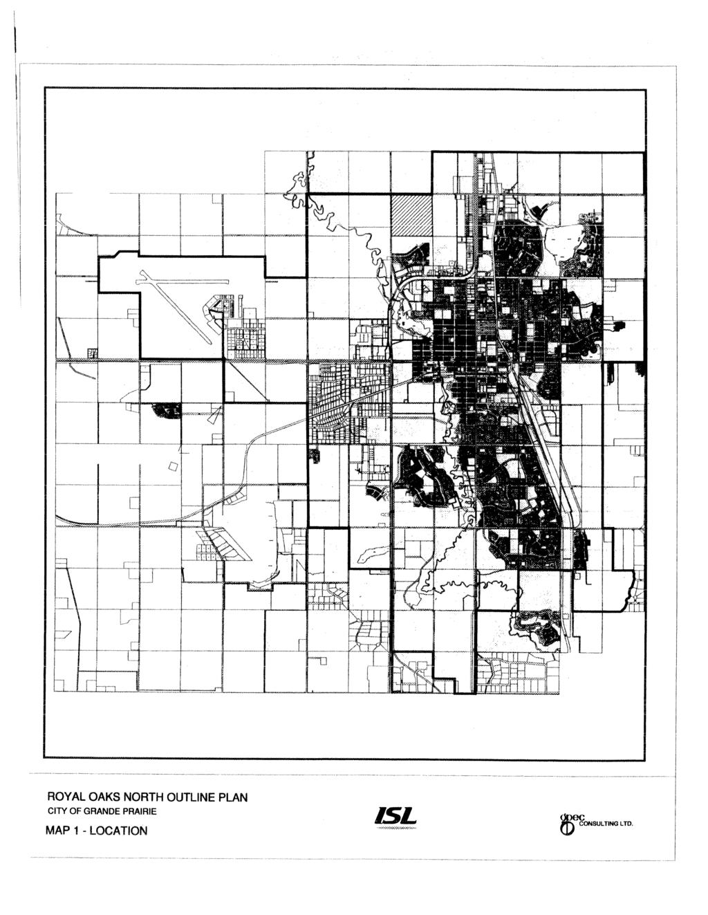
3 Royal Oaks North Outline Plan LIST OF MAPS Map 1 Plan Area Location OP September 10, 2007 Map 2 Existing Conditions OP 07 03B July 12, 2010 Map 3 Topography OP September 10, 2007 Map 4 Land Use OP 07 03B July 12, 2010 Map 5 Tentative Lotting OP 07 03B July 12, 2010 Map 6 Open Space OP 07 03B July 12, 2010 Map 7 Transportation OP 07 03B July 12, 2010 Map 8 Water System OP 07 03B July 12, 2010 Map 9 Sanitary Sewer OP 07 03B July 12, 2010 Map 10 Storm Drainage OP 07 03B July 12, 2010 Map 11 Phasing OP 07 03B July 12, 2010 Map 12 Zoning OP 07 03B July 12, 2010 LIST OF TABLES 1 Plan Area Composition 2 Land Use Summary 3 Population and Student Generation The City of Grande Prairie Page 2
4 Royal Oaks North Outline Plan 1.0 INTRODUCTION 1.1 Purpose of Plan The Royal Oaks North Outline Plan (OP) has been prepared on behalf of the owners of the subject lands to provide a detailed framework for the future development of lands in northwest Grande Prairie for residential purposes. This OP has been prepared in accordance with Policy of the City of Grande Prairie Municipal Development Plan. As required by this policy, the Plan addresses the following: Physical features and development constraints; Future land use and development concept, including lot layout; Proposed transportation network, including the approximate alignment of future arterial, collector and local roads; Disposition of municipal reserve; Proposed servicing for the area; and Intended phasing of development. 1.2 Plan Area Location This OP applies to 63.5 ha of land that is bounded to the north by 132 Avenue and to the west by 108 Street as indicated in Map 1. The Royal Oaks neighbourhood is located to the south of the subject land, while the lands to the north, west and east are currently in agricultural use, but are all proposed for future residential development. 1.3 Ownership and Dispositions As outlined in Table 1, the Plan area consists of two parcels totaling 63.5 ha. There are no encumbrances on title that affect the future development of the subject lands. Table 1 Plan Area Composition Legal Owner Area (ha) NW W6M Pt. NW W6M Road Plan Diamond Head Enterprises Ltd. L. and D. Larsen City of Grande Prairie Total 63.5 The City of Grande Prairie Page 3
5 Royal Oaks North Outline Plan 1.4 Policy and Regulatory Context The Royal Oaks North OP has been prepared in accordance with the requirements of the Grande Prairie Municipal Development Plan (MDP). This OP is consistent with MDP policies respecting the utilization of spare servicing capacity and the development of an efficient land use pattern. This OP is also guided by the policies and development concepts contained in the Northridge ASP. This OP is at variance with this ASP, warranting an amendment as outlined in Section 4.2. The Plan area is currently designated as Urban Reserve (UR) in the Grande Prairie Land Use Bylaw. The subject lands will be rezoned to reflect the land uses contained in this OP prior to subdivision and development approval. 1.5 Site Characteristics As illustrated in Map 2 the Plan area is predominantly farm land. The northwest portion of the Plan area is characterized by a low marsh area of approximately 11 ha in size. Although predominantly in its natural state, a portion of this wetland located on the parcel identified as the Larsen Property has been the subject of peat excavation, creating a water body in this area. Current development is limited to a farm site on the Larsen Property. Map 3 shows that the Plan area is characterized by relatively flat topography, with elevations ranging from 673 m at the northeast corner to 665 m at the southwest corner and the marsh area. Generally the north 60% of the Plan area drains to the marsh, while the remainder drains to the southwest. The City of Grande Prairie Page 4
6 Royal Oaks North Outline Plan 2.0 DEVELOPMENT PLAN 2.1 Plan Objectives The Royal Oaks North OP is intended to achieve the following objectives: 1. To provide an overall framework for future residential and open space development in northwest Grande Prairie that is compatible with development located on, or proposed for, adjacent lands; 2. To provide for the development of an attractive residential neighbourhood; 3. To develop a safe and efficient transportation network that meets the needs of passenger vehicles, pedestrians, cyclists, and public transit; and 4. To develop an efficient municipal servicing and phasing system for the Plan area. 2.2 Development Concept General The proposed land use concept for the Royal Oaks North OP is illustrated in Map 4, and a summary of land uses is provided in Table 2. It is proposed that the Plan area be developed predominantly for low density residential use. As indicated in Table 2, the net developable area available is approximately 63.2 hectares. Table 2 Land Use Summary Land Use NW 35 (ha) Pt. NW 35 (ha) Total (ha) Percent Gross Area Less Road Plan Net Developable Area Residential Single Family Multi Family (Low Density) Multi Family (Medium Density) Open Space Neighbourhood Parks School Sites Roads Road Widening Internal Roads Utilities Storm Pond Public Utility Lots Church The City of Grande Prairie Page 5
7 Royal Oaks North Outline Plan Residential Development The largest single land use in the Plan is single family residential development, totaling approximately 23 ha and occupying 37% of the Plan area. The majority of the single family lots are to have a minimum lot width of m, totaling 535 units as outlined in Table 3. A tentative lotting plan is provided in Map 5. A node of low density multi family development totaling 3.4 ha is proposed for the west side of the Plan area adjacent to 108 Street. Assuming an average lot width of 7.4 m, an additional 131 units may be developed at this location. It is assumed that semi detached or similar dwelling forms that are compatible with adjacent single family residential development would be developed in this area. Population Generation Table 3 Population and Student Generation Single Family Units Single Family Population Multi Family Units (LD) Multi Family (LD) Population Multi Family Units (MD) Multi Family (MD) Population Total Multi Family Population Total Population Student Generation 1 Total Students Total Public Total Separate Public School Students Total Students Total K 9 Total Separate School Students Total Students Total K 9 Total m 2 min. lot size ppu m 2 avg lot size ppu units/ha ppu 20.5% of Population 62.2% of Total Students 37.8% of Total Students 74.6% of Students 25.4% of Students 80.7% of Students 19.3% of Students 548 units 1, units units , Two medium density multi family nodes are also proposed for the Plan area, one 1.7 ha site located adjacent to the north school site and 132 Avenue, and another 2.0 ha site at the east entrance to the neighbourhood. Assuming a density of 50 units per hectare, 184 units may be accommodated at these locations. 1 Based on school enrolments as of September 29, The City of Grande Prairie Page 6
8 Royal Oaks North Outline Plan As illustrated in Table 3, it is anticipated that a total of 832 units and 2,316 residents may be accommodated in the Plan area, with 475 estimated to be of school age. Overall, the area will accommodate an average residential density of units and 36.6 persons per net developable hectare Church Site The portion of the Plan area referred to as the Larsen Property has recently been purchased for the development of a church, and a site of approximately 5.6 ha has been identified on the west side of the Plan area for this purpose. The actual size of the site will be determined at the time of detailed engineering design and survey, however, as it will be dependent on the amount of land required for stormwater management purposes Open Space The following is a detailed breakdown of municipal reserve allocation as illustrated in Map 6: A 4.03 ha parcel of land is allocated in the southeast corner of the Plan area to accommodate a portion of a proposed joint school site in accordance with the Northridge ASP. A 2.14 ha parcel is also allocated in the northeast portion of the Plan area to accommodate a proposed elementary school site. Two neighbourhood parks, averaging 0.36 ha in size is to be provided in the Plan area. The furnishing of these parks will be discussed in detail in the Parks Design Report. It should be noted that the MR dedication for the Plan area is approximately 11% of the total available in the Plan area, which exceeds the 10% maximum provided in the Municipal Government Act by 0.58 ha. This is attributable to the school site allocation and a lack of reserve dedication on the Larsen property due to the nature of the development proposed. As outlined in Table 4, the NW 35 is over dedicated by 1.43 ha. Although the 0.85 ha amount may be recovered from the owners of the Larsen property at such time as it is subdivided, it is also necessary that the City compensate the owner of the NW 35 for the additional 0.58 ha owed that is directly attributed to the provision of the school sites. Table 4 Municipal Reserve Allocation NW 35 Pt NW 35 Total Reserve Allocation (ha) Reserve Owing (10% of Area) (ha) Percent of Developable Area Over/Under Dedication (ha) For the purpose of this calculation, the Larsen Property has been excluded from the Net Developable Area as no permanent residents will be located on the property. The Net Developable Area is therefore limited to ha. The City of Grande Prairie Page 7
9 Royal Oaks North Outline Plan 3.0 INFRASTRUCTURE 3.1 Transportation Network As illustrated in Map 7, the Plan area is served by two arterial roadways: 132 Avenue to the north and 108 Street to the west. Both of these roads are currently developed to a two lane gravel standard, but according to the City s Transportation Master Plan are to be ultimately constructed to a four lane divided arterial standard. In order to accommodate the eventual upgrading of these roads, lands along the north and west boundaries of the Plan area have been set aside for widening. In addition, lots backing on to these roads have been designed with extra depth in order to accommodate noise attenuation measures. Major collector access to the Royal Oaks North area is provided from 108 Street at 128 Avenue, from 132 Avenue at 104A Street, and via 105 Street from Royal Oaks to the south. 128 Avenue also bisects the centre of the Plan area, linking to 108 Street to the west and the future Northridge neighbourhood to the east. The balance of the Plan area is to be served by a network of local roads. The Larsen Property currently obtains access directly from 108 Street, and it is assumed that direct access to this site will remain once the site is developed for a church. It is anticipated that this access will be located approximately 300m south of 132 Avenue, but will be confirmed through the preparation of a Traffic Impact Assessment prior to development of the church site. An alternative access (requiring OP amendment) internal to the subdivision is shown in Map 7 should the Larsen property be amended and developed under a different land use. Access to 108 Street will be reviewed by the City at the time of OP amendment. Accommodation for pedestrians and cyclists is provided through the development of an asphalt trail and concrete sidewalk network that provides connections to future trails along 132 Avenue and 108 Street. Internal connections are also provided to the school sites in accordance with the Northridge ASP. 3.2 Water Distribution There are three main water feeds to the Plan area. The first connection of the water system will be to an existing 300mm diameter PVC main installed as part of the Royal Oaks Phase 5B development. This main is currently stubbed at the SW corner of the subject land. The second connection will be to a 150mm diameter PVC watermain at the north limit of the existing 105 Street. This main was installed as part of the Royal Oaks Phase 5D development. The final connection is a 300mm diameter PVC main and will be on the east limit of the subject land at 128 Avenue. No development or piping exists in this area at this time, but it is anticipated that this infrastructure will exist prior to Royal Oaks North phasing in this area. The proposed watermain system for the area is outlined in Map 8. Additional information pertaining to the water distribution/fire system is outlined in the detailed design report for water. The City of Grande Prairie Page 8
10 Royal Oaks North Outline Plan 3.3 Sanitary Sewer Sanitary sewer flows for the subject land will all be collected through a 450mm diameter main aligned internally through the subdivision. Ultimately, this sanitary main will also accommodate the lands to the north (SW W6M) and approximately two thirds of the lands to the northwest (SE W6M). The internal network of piping will consist of a series of 200mm diameter mains. The proposed sanitary sewer system for the Plan area is illustrated on Map 9. Additional detailed information pertaining to the sanitary system is outlined in the design report for sanitary. 3.4 Stormwater Management A portion of the stormwater flows from the subject lands can be accommodated through the existing Royal Oaks storm sewer system. The southwest portion of the development will flow through existing storm mains and into the Royal Oaks storm retention pond. The remainder of the storm flows will utilize a wet pond constructed as part of the Royal Oaks North development. This pond will also be sized to handle flows from the lands to the north (SW W6M). This storm facility will be located in the centre of the subject land and is currently a low lying area which cannot be used for agricultural or development purposes. Engineered fill shall be applied to that portion of the wetland that is to be redeveloped for residential purposes to ensure that it is suitable for development 3. The redevelopment of the wetland for stormwater management purposes is in the process of being approved by Alberta Environment, and will be the subject of compensation to the Department 4. The wet pond will be constructed in the second phase of the development, as a result, only the rezoning of Phase 1 will be permitted by the City until such time as this pond is developed. The proposed storm sewer system for the Plan area is illustrated on Map 10. Additional information pertaining to the storm drainage system is outlined in the detailed design report for stormwater management. 3.5 Shallow Utilities All shallow utilities (natural gas, power, telephone) are to be extended into the Plan area by the individual franchise holders as required. The right of way for the existing natural gas pipeline located on the north side of the Plan area shall be incorporated into the widened 132 Avenue road right of way. In accordance with City policy, with the exception of 25 kv and higher feeder lines, any overhead distribution lines located adjacent to residential areas will be installed underground at the developers expense. 3 In addition, the specific sizing of that portion of the wet pond located on the Larsen Property will be confirmed through detailed engineering design. As noted in Section 2.2.3, the storm pond requirements will determine the developable area available for the church site. 4 At the time of writing of this outline plan, the amount of compensation has been determined and development approvals from Alberta Environment are forthcoming. The City of Grande Prairie Page 9
11 Royal Oaks North Outline Plan 4.0 IMPLEMENTATION 4.1 Phasing A tentative phasing plan is provided in Map 11. It is intended that development of the subject lands start at the west side of the Plan area in order to take advantage of service and access connections from Royal Oaks. Development will then proceed to the north and south as conditions warrant. Notwithstanding the above, the north school site may be developed in advance of Phase 4 subject to the agreement of the owner, the City, the public and/or separate school board and Aquatera Utilities Inc. with respect to the provision of access and services. 4.2 Statutory Plan Amendments The Northridge ASP was approved in August 1999 and subsequently amended in May In order to accommodate this OP, however, additional amendments were required as follows: The proposed collector road network is at variance with that shown in the ASP as the intersection of the east west collector (128 Avenue) with 108 Street is provided at a point further to the south than is shown in the ASP. The size and configuration of the medium density residential illustrated adjacent to the eastwest collector has been changed, and a second multi family site has been added. The southerly portion of the Larsen Property is being changed from low density residential to a church site. In addition, the access locations into the Plan area were at variance with the Hidden Valley ASP, which addressed future development on the west side of 108 Street. An amendment to this ASP was also required to address this issue. 4.3 Proposed Zoning Proposed zoning for the Plan area is identified in Map 12. The areas slated for single family residential development will be zoned under the Residential General (RG) District of the Land Use Bylaw. Combined Density Residential (RC) and Medium Density (RM) zoning is proposed for the multi family nodes located on the west side and north side of the Plan area respectively. The school and church sites will be zoned under the Public Service (PS) District. Due to the phasing of the storm pond, only the rezoning of Phase 1 will be made concurrently with OP approval. The rezoning of all other areas will be made in advance of subdivision. The City of Grande Prairie Page 10
12
 108 ST")
13 132 AVENUE C. of T. ("Larson Property") 108 STREET * NW W6M ROYAL OAKS NORTH OUTLINE PLAN CITY OF GRANDE PRAIRIE Scale: N.T.S. * Residence Low Area Natural Gas Pipeline MAP 2 - EXISTING CONDITIONS Plan Area January 2007
14
15
16
17
18
19
20
21
22
23
OP Council Resolution June 16, Planning and Development Services
 OP-08-01 Council Resolution June 16, 2008 Planning and Development Services Kingsgate Landing Outline Plan Table of Contents 1.0 Introduction 1 1.1 Purpose of Plan 1 1.2 Plan Area Location 1 1.3 Ownership
Bylaw C-1262 Adopted February 6, Planning and Development Department
 Bylaw C-1262 Adopted February 6, 2012 Planning and Development Department CITY OF GRANDE PRAIRIE BYLAW C-1262 A Bylaw to adopt the Brookfield Neighbourhood Outline Plan THE MUNICIPAL COUNCIL OF THE CITY
City of Grande Prairie Development Services Department KENNEDY DEVELOPMENTS LTD. OUTLINE PLAN OP-09-01
 City of Grande Prairie Development Services Department KENNEDY DEVELOPMENTS LTD. OUTLINE PLAN OP-09-01 July 27, 2009 TABLE OF CONTENTS 1.0 Introduction... 1 1.1 Plan Area Location & Context... 1 1.2 Ownership
C ity of Grande Prairie Development Services Department
 C ity of Grande Prairie Development Services Department FAIRWAY DEVELOPMENT OUTLINE PLAN OP 08 09 Approved April 6, 2009 Prepared by: Focus Corporation Table of Contents 1.0. Introduction 2 3 1.1. Plan
S o u t h C e n t r a l O u t l i n e P l a n. Leduc Business Park. North Leduc Industrial Area Structure Plan C it y of Led u c.
 Leduc Business Park North Leduc Industrial Area Structure Plan C it y of Led u c Prepared for Farm Air Properties Inc. January, 2007 Table of Contents Page Number 1.0 Purpose of Plan and Definition of
Bylaw C-1186 Adopted November 5, Planning and Development Services
 Bylaw C-1186 Adopted November 5, 2007 Planning and Development Services CITY OF GRANDE PRAIRIE OFFICE CONSOLIDATION BYLAW C-1186 A Bylaw to adopt the Westgate Area Structure Plan (As Amended by Bylaw C-1186-1,
WEST HILL BUSINESS PARK AREA STRUCTURE PLAN
 MUNICIPAL DISTRICT OF PEACE NO. 135 WEST HILL BUSINESS PARK AREA STRUCTURE PLAN Prepared by: TABLE OF CONTENTS 1.0 Introduction... 1 1.1 Purpose of Plan........ 1 1.2 Plan Area..... 1 1.3 Existing Conditions...
Leduc Industrial Outline Plan SE W4
 Leduc Industrial Outline Plan SE 1-50-25-W4 Within the North Leduc Industrial ASP Prepared for: Leduc Energy Park Ltd. Prepared by: Stantec Consulting Ltd. File No. 1161 104655 V5 Table of Contents 1.0
ADMINISTRATION RECOMMENDATION 2016 November 03. That Calgary Planning Commission recommends APPROVAL of the proposed Land Use Amendment.
 Page 1 of 12 EXECUTIVE SUMMARY This Land Use Amendment application covers an area of 75.76 hectares ± (187.20 acres ±) located in northeast Calgary, bound by Stoney Trail NE to the north, 128 Avenue NE
Bylaw No. B-03/2011 Adopted by Airdrie City Council February 21, 2012
 COOPER S CROSSING STAGE 4 Neighbourhood Structure Plan City of Airdrie WESTMARK HOLDINGS LTD. Bylaw No. B-03/2011 Adopted by Airdrie City Council February 21, 2012 CONSULTANTS: LAND USE PLANNING: Southwell
LAND USE AMENDMENT CORNERSTONE (WARD 3) COUNTRY HILLS BOULEVARD AND STONEY TRAIL NE BYLAW 9D2017
 COUNTRY HILLS BOULEVARD AND STONEY TRAIL NE BYLAW 9D2017") Page 1 of 12 EXECUTIVE SUMMARY This Land Use Amendment application covers an area of 54.92 hectares ± (135.71 acres ±) located in northeast Calgary, bound by Country Hills Boulevard NE to the north and
Page 1 of 12 EXECUTIVE SUMMARY This Land Use Amendment application covers an area of 54.92 hectares ± (135.71 acres ±) located in northeast Calgary, bound by Country Hills Boulevard NE to the north and
Outline Plan in Belvedere (Ward 9) at Street SE, LOC (OP)
 at Street SE, LOC (OP)") 2018 October 04 Page 1 of 12 EXECUTIVE SUMMARY This outline plan application was submitted by B&A Planning Group on 2016 July 15, on behalf of Tristar Communities Inc. for 50.14 hectares (123.89 acres)
2018 October 04 Page 1 of 12 EXECUTIVE SUMMARY This outline plan application was submitted by B&A Planning Group on 2016 July 15, on behalf of Tristar Communities Inc. for 50.14 hectares (123.89 acres)
LAND USE AMENDMENT CORNERSTONE (WARD 3) 60 STREET NE AND COUNTRY HILLS BOULEVARD NE MAP 26NE BYLAW 22D2017
 60 STREET NE AND COUNTRY HILLS BOULEVARD NE MAP 26NE BYLAW 22D2017") Page 1 of 14 EXECUTIVE SUMMARY This Land Use Amendment application covers an area of 43.76 hectares ± (108.14 acres ±) located in northeast Calgary, bound by Country Hills Boulevard NE to the south and
Page 1 of 14 EXECUTIVE SUMMARY This Land Use Amendment application covers an area of 43.76 hectares ± (108.14 acres ±) located in northeast Calgary, bound by Country Hills Boulevard NE to the south and
Palisades Outline Plan
 NE ¼ 25 36 28 W4 Town of Penhold Approved August 13, 2012 Contents Figures & Tables... 2 Introduction... 1 Overview... 1 Purpose... 1 Development Area... 3 Ownership... 3 Topography... 3 Existing & Surrounding
The Uplands Area Structure Plan. City of Cold Lake, NE & SE W4
 City of Cold Lake, NE & SE 13-63-2-W4 July 2009 1 Contents 1 Background information... 1 1.1 Foreword... 1 1.2 Purpose... 1 1.3 Plan Area and Location... 1 1.4 Ownership... 2 2 Factors Influencing Development...
TABLE OF CONTENTS. Sierra Springs Outline Plan
 Sierra Springs Outline Plan TABLE OF CONTENTS 1. Introduction...3 1.1. Purpose of the Plan... 3 1.2. The Approval Process... 3 1.3. Policy and Legislative Framework... 3 2. Development Area...6 2.1. Location
City of Spruce Grove East Campsite Business Park Area Structure Plan
 City of Spruce Grove East Campsite Business Park Area Structure Plan Prepared by: UMA Engineering Ltd. 17007 107 Avenue Edmonton, AB T5S 1G3 T 780.486.7000 F 780.486.7070 www.uma.aecom.com Job No. 1560
Mayliewan Neighbourhood Structure Plan Neighbourhood 7 of the Edmonton North Area Structure Plan
 Mayliewan Neighbourhood Structure Plan Neighbourhood 7 of the Edmonton North Area Structure Plan Office Consolidation November 2008 Prepared by: Planning and Policy Services Branch Planning and Development
HAMPTONS Area Structure Plan Medicine Hat, Alberta
 HAMPTONS Medicine Hat, Alberta Prepared for: Lansdowne Equity Ventures Ltd. Prepared by: UMA Engineering Ltd. May 2005 Table of Contents Page No. 1. INTRODUCTION...1 1.1 Purpose...1 1.2 Location & Existing
ADMINISTRATION RECOMMENDATION(S) 2017 February 09. That Calgary Planning Commission recommends APPROVAL of the proposed Land Use Amendment.
 2017 February 09. That Calgary Planning Commission recommends APPROVAL of the proposed Land Use Amendment.") Page 1 of 10 EXECUTIVE SUMMARY This land use amendment application is to accommodate changes to the location of a stormwater retention pond and land use boundaries adjacent to Environmental Reserve in
Page 1 of 10 EXECUTIVE SUMMARY This land use amendment application is to accommodate changes to the location of a stormwater retention pond and land use boundaries adjacent to Environmental Reserve in
Bylaw 884/13 Schedule A. Town of Rimbey. June 2008.
 Bylaw 884/13 Schedule A Town of Rimbey June 2008. Revised April 2013 Bylaw 884/13 Schedule A Johnson Estates Table of Contents 1. Introduction... 11 1.1 Purpose... 11 1.2 Location Context... 11 1.3 Land
Red Fox Commercial Outline Plan
 Red Fox Commercial Outline Plan City of Cold Lake, Alberta Prepared by Durrance Projects Ltd and Ross W. Sharp & Associates Ltd October 2014 Rupert 1 Table of Contents 1. PURPOSE...3 1.1. Location...4
ADMINISTRATION RECOMMENDATION(S) 2017 June 15. That Calgary Planning Commission recommends APPROVAL of the proposed Land Use Amendment.
 2017 June 15. That Calgary Planning Commission recommends APPROVAL of the proposed Land Use Amendment.") Page 1 of 7 EXECUTIVE SUMMARY The proposed land use amendment seeks to redesignate a Special Purpose Future Urban Development (S-FUD) District parcel in Residual Ward 3 Sub Area 3H to Industrial Outdoor
Page 1 of 7 EXECUTIVE SUMMARY The proposed land use amendment seeks to redesignate a Special Purpose Future Urban Development (S-FUD) District parcel in Residual Ward 3 Sub Area 3H to Industrial Outdoor
This application has been applied for with support of an Outline Plan to provide the technical details for the site s development.
 Page 1 of 13 EXECUTIVE SUMMARY This application consists of a Land Use Amendment application proposing redesignation from Special Purpose Future Urban Development (S-FUD) District to an assortment of multiresidential,
Prepared for: Prepared by: Revised November 2013 by Stantec Consulting Ltd. 200, th Street Se Calgary, AB, T2A 7H8
 Prepared for: Prepared by: PLANNING PROTOCOL INC. 3916 1 ST STREET N.E. CALGARY, AB. T2E 3E3 Revised November 2013 by Stantec Consulting Ltd. 200, 325 25 th Street Se Calgary, AB, T2A 7H8 Table of Contents
Area Structure Plan. South East Leduc Area Structure Plan. In the City of Leduc, Alberta. August Prepared for: Report No.
 Area Structure Plan In the City of Leduc, Alberta August 2014 Prepared for: Report No. 6162-03 5307 47 Street, Edmonton, Alberta T6B 3T4 Phone: (780) 440-4411 Fax: (780) 440-2585 August 2014 TABLE OF CONTENTS
BYLAW NO. 3549/2015. Being a Bylaw of The City of Red Deer to provide a uniform levy of off-site costs in respect of previously undeveloped land.
 BYLAW NO. 3549/2015 Being a Bylaw of The City of Red Deer to provide a uniform levy of off-site costs in respect of previously undeveloped land. 1 WHEREAS pursuant to provisions of Section 648 of the Municipal
Westwind Developments Ltd. PIONEER LANDS AREA STRUCTURE PLAN - PROPOSED AMENDMENT
 FEBRUARY 2013 TABLE OF CONTENTS 1.0 BACKGROUND... 1 1.1 Amendment... 1 2.0 LOCATION & CONTEXT... 2 2.1 Land Ownership... 2 3.0 POLICY CONTEXT... 3 3.1 Municipal Development Plan... 3 3.2 Capital Region
RESIDENTIAL PLANNED UNIT DEVELOPMENT / SUBDIVISION AND REZONING CONCEPT AND DEVELOPMENT STAGE PLAN SUBMITTAL NARRATIVE
 RESIDENTIAL PLANNED UNIT DEVELOPMENT / SUBDIVISION AND REZONING CONCEPT AND DEVELOPMENT STAGE PLAN SUBMITTAL NARRATIVE DEVELOPMENT TEAM DONEGAL SOUTH Maple Grove, Minnesota March 27, 2017 Applicant/Developer/Builder:
GATEWAY AREA STRUCTURE PLAN
 CHESTERMERE GATEWAY AREA STRUCTURE PLAN COMMUNITY OPEN HOUSE SEPTEMBER 22 nd, 2015 PLAN AREA ± 512 hectares (± 1,265 acres) GATEWAY LOCATION UNDEVELOPED LANDS PRESENT AGRICULTURAL USE REGIONAL LAND USE
Oxford Neighbourhood Structure Plan
 Oxford Neighbourhood Structure Plan Office Consolidation November 2010 Prepared by: Planning and Policy Services Branch Planning and Development Department City of Edmonton Bylaw 7963, was adopted by Council
BEAU VAL PARK/ BEAUMONT LAKES SOUTH Area Structure Plan
 BEAU VAL PARK/ BEAUMONT LAKES SOUTH (Parcels A/B/C/D, Plan 1912 EO, Plan 1025 KS) Prepared For: 1871368 AB Ltd. Presented By: DGE Civil Engineering Consultants 221, 9223-28 Avenue Edmonton, AB T6N 1N1
Land Use Amendment in Southwood (Ward 11) at and Elbow Drive SW, LOC
 at and Elbow Drive SW, LOC") 2018 November 15 Page 1 of 10 EXECUTIVE SUMMARY This land use amendment application was submitted by Rick Balbi Architect on 2017 August 31 on behalf of Sable Developments Ltd, and with authorization from
2018 November 15 Page 1 of 10 EXECUTIVE SUMMARY This land use amendment application was submitted by Rick Balbi Architect on 2017 August 31 on behalf of Sable Developments Ltd, and with authorization from
AREA STRUCTURE PLAN NE W5M. Adopted by Council September 27, 2010 Bylaw
 AREA STRUCTURE PLAN NE 5-33-1 W5M Adopted by Council September 27, 2010 Bylaw 2010-14 CONTENTS 1.0 Introduction... 3 1.1 Purpose... 3 1.2 Objectives... 3 1.3 Discovery Plains Community Vision... 3 1.3.1
GRAYSTONE ESTATES CONCEPTUAL SCHEME
 GRAYSTONE ESTATES CONCEPTUAL SCHEME Bylaw C-5438-2001, Adopted November 6, 2001 MUNICIPAL DISTRICT OF ROCKY VIEW NO. 44 Department of Planning and Development TABLE OF CONTENTS 1.0 INTRODUCTION 5 1.1 Conceptual
Ebbers Neighbourhood Area Structure Plan
 Ebbers Neighbourhood Area Structure Plan Office Consolidation November 2016 Prepared by: City Planning Branch Sustainable Development City of Edmonton Bylaw 14079, was adopted by Council in February 2006.
Clearview North. Neighborhood Area Structure Plan. Reference# Ross Stre I Red Deer AB T4N 1X5. March 2009
 Clearview North Neighborhood Area Structure Plan Reference# 112870942 SLlr I _ Cv... ulhr.g l..v 600 4808 Ross Stre I Red Deer AB T4N 1X5 March 2009 Amended on March 23, 2009 Bylaw 3217/B-2009 Clearview
Hollick Kenyon Neighbourhood Structure Plan
 Hollick Kenyon Neighbourhood Structure Plan Office Consolidation June 2010 Prepared by: Planning and Policy Services Branch Planning and Development Department City of Edmonton Bylaw 9744 was adopted by
Bylaw No Page 1
 Bylaw No. 876-2014 Page 1 A BYLAW OF THE CITY OF LEDUC IN THE PROVINCE OF ALBERTA, TO ADOPT THE AREA STRUCTURE PLAN FOR THE: SOUTH WEST QUARTER OF 31-49-25-W4M The Municipal Government Act, R.S.A. 2000,
BRIDGES OF LANGDON CONCEPTUAL SCHEME
 BRIDGES OF LANGDON CONCEPTUAL SCHEME Office Consolidation This page contains the history of relevant bylaws affecting this office consolidation. A copy of the original Bylaw and all amending Bylaws can
Welcome. Middle School, School Ground Amenities, & Future Fire Station Location
 Welcome Middle School, School Ground Amenities, & Future Fire Station Location LAND DEVELOPMENT PROCESS MUNICIPAL DEVELOPMENT PLAN The Municipal Development Plan is a broad, long range land use planning
THE CITY OF SPRUCE GROVE BYLAW C PIONEER LANDS AREA STRUCTURE PLAN AMENDMENT
 THE CITY OF SPRUCE GROVE BYLAW C-797-11 PIONEER LANDS AREA STRUCTURE PLAN AMENDMENT WHEREAS, pursuant to the Municipal Government Act, R.S.A., 2000, c.m-26, a municipality shall adopt Area Structure Plans
ADMINISTRATION RECOMMENDATION(S) 2016 November 03. That Calgary Planning Commission recommends APPROVAL of the proposed Land Use Amendment.
 2016 November 03. That Calgary Planning Commission recommends APPROVAL of the proposed Land Use Amendment.") Page 1 of 7 EXECUTIVE SUMMARY This Land Use Amendment application seeks to redesignate a portion of the parcel from Industrial General (I-G) District to Special Purpose City and Regional Infrastructure
Page 1 of 7 EXECUTIVE SUMMARY This Land Use Amendment application seeks to redesignate a portion of the parcel from Industrial General (I-G) District to Special Purpose City and Regional Infrastructure
THE CITY OF SPRUCE GROVE BYLAW C PIONEER LANDS AREA STRUCTURE PLAN AMENDMENT
 THE CITY OF SPRUCE GROVE BYLAW C-932-15 PIONEER LANDS AREA STRUCTURE PLAN AMENDMENT WHEREAS, pursuant to the Municipal Government Act, R.S.A. 2000, c. M-26, including amendments, a municipality may adopt
Canossa NSP. Office Consolidation August Prepared by: Planning and Policy Services Branch Planning and Development Department City of Edmonton
 Canossa NSP Office Consolidation August 2004 Prepared by: Planning and Policy Services Branch Planning and Development Department City of Edmonton Bylaw 7613 (as amended) was adopted by Council October
The Hamptons Neighbourhood Structure Plan
 The Hamptons Neighbourhood Structure Plan Office Consolidation December 2014 Prepared by: City Planning City of Edmonton Bylaw 11751, was adopted by Council in June 1998. In December 2014, this document
Terra Losa Neighbourhood Structure Plan
 Terra Losa Neighbourhood Structure Plan Office Consolidation May 2006 Prepared by: Planning and Policy Services Branch Planning and Development Department City of Edmonton Bylaw 6616 was adopted by Council
Chappelle Neighbourhood Area Structure Plan
 Chappelle Neighbourhood Area Structure Plan Office Consolidation September 2017 Prepared by: City Planning Urban Form and Corporate Strategic Development City of Edmonton Bylaw 14779 was adopted by Council
WINTERBURN INDUSTRIAL AREA STRUCTURE PLAN
 OCTOBER 2009 Winterburn Industrial Area Structure Plan Office Consolidation November 2012 Prepared by: Current Planning Branch Sustainable Development City of Edmonton Bylaw 15356, was adopted by Council
Schonsee Neighbourhood Structure Plan of the Edmonton North Area Structure Plan
 Schonsee Neighbourhood Structure Plan of the Edmonton North Area Structure Plan Office Consolidation September 2010 Prepared by: Planning and Policy Services Branch Planning and Development Department
Central and East Neighbourhoods - Hermitage Outline Plan
 Central and East Neighbourhoods - Hermitage Outline Plan Office Consolidation September 2013 Prepared by: Planning and Policy Services Branch Planning and Development Department City of Edmonton The Central
Terra Losa Neighbourhood Structure Plan
 Terra Losa Neighbourhood Structure Plan Office Consolidation January 22, 2018 Prepared by: City Planning Urban Form and Corporate Strategic Development City of Edmonton Bylaw 6616 was adopted by Council
AREASTRUCTURE PLAN AMENDMENT COCHRANE NORTH
 AREASTRUCTURE PLAN AMENDMENT COCHRANE NORTH In order to implement the vision outlined in the Conceptual Scheme, the following three amendments to the Cochrane North ASP are proposed: 1. Allow commercial
POLICY AMENDMENT AND LAND USE AMENDMENT KILLARNEY/GLENGARRY (WARD 8) NW CORNER OF RICHMOND ROAD AND 33 STREET SW BYLAWS 1P2015 AND 7D2015
 NW CORNER OF RICHMOND ROAD AND 33 STREET SW BYLAWS 1P2015 AND 7D2015") Page 1 of 13 EXECUTIVE SUMMARY This application seeks to redesignate an RC-2 (Residential Contextual One/Two Dwelling) parcel to MC-Gd72 (Multi-Residential Contextual Grade-Oriented) to allow for multi-residential
Page 1 of 13 EXECUTIVE SUMMARY This application seeks to redesignate an RC-2 (Residential Contextual One/Two Dwelling) parcel to MC-Gd72 (Multi-Residential Contextual Grade-Oriented) to allow for multi-residential
9 th Street Sub Area Plan
 9 th Street Sub Area Plan In the 1990 s, when the Township prepared the last Master Plan, the 9 th Street corridor was studied as part of a larger 9 th Street Focus Area that included the West Main Street
CENTRAL PARK MAJOR AREA STRUCTURE PLAN. Bylaw No. 2017/30, Adopted February 20, P a g e
 CENTRAL PARK MAJOR AREA STRUCTURE PLAN Bylaw No. 2017/30, Adopted February 20, 2018 1 P a g e Table of Contents 1.0 Introduction 4 1.1 Background 4 1.2 Purpose 4 1.3 Location 4 1.4 Planning Process 4
MICHENER HILL EAST. Neighbourhood Area Structure Plan. - Red Deer - InterPLAN strategies inc.
 MICHENER HILL EAST Neighbourhood Area Structure Plan - Red Deer - InterPLAN strategies inc. Adopted by City Council, Bylaw 3217/E-2007, June 18, 2007 Michener Hill East Neighbourhood Area Structure Plan
5.0 Community Design Plan
 5.0 Community Design Plan The Community Design Plan for the Mer Bleue area is a composite of three plans: Land Use Plan Transportation Plan Municipal Servicing Plan Read together, these Plans and associated
ROAD CLOSURE AND LAND USE AMENDMENT SILVER SPRINGS (WARD 1) NORTHEAST OF NOSEHILL DRIVE NW AND SILVER SPRINGS ROAD NW BYLAWS 2C2018 AND 29D2018
 NORTHEAST OF NOSEHILL DRIVE NW AND SILVER SPRINGS ROAD NW BYLAWS 2C2018 AND 29D2018") Page 1 of 19 EXECUTIVE SUMMARY This application proposes redesignating two parcels in the community of Silver Springs from Special Purpose Future Urban Development (S-FUD) District and undesignated road
Page 1 of 19 EXECUTIVE SUMMARY This application proposes redesignating two parcels in the community of Silver Springs from Special Purpose Future Urban Development (S-FUD) District and undesignated road
THE CITY OF WINNIPEG BY-LAW NO. 97/2014
 THE CITY OF WINNIPEG BY-LAW NO. 97/2014 A By-law of THE CITY OF WINNIPEG to adopt a secondary plan for Precinct E of the Complete Communities Direction Strategy By-law No. 68/2010. THE CITY OF WINNIPEG,
NEIGHBORHOOD STRUCTURE PLAN
 June 19, 2006 BYLAW 05/2006 NEIGHBORHOOD STRUCTURE PLAN ADOPTED BY CITY COUNCIL June 19, 2006 BYLAW 05/2006 Prepared for: Hopewell Residential Communities Prepared by: Brown & Associates Planning Group
PLANNING COMMISSION. Submitted
 PLANNING COMMISSION City Hall 1275 Main Street El Centro, CA 92243 Submitted PLANNING COMMISSION ACTION ITEM (1844) Meeting: 05/10/16 12:00 AM Department: Community Development Category: Public Hearing
CITY COUNCIL AGENDA REPORT
 CITY COUNCIL AGENDA REPORT Subject: BYLAW 21/2013 - VILLE GIROUX AREA STRUCTURE PLAN AMENDMENT BYLAW 23/2013 - REDISTRICTING, VILLE GIROUX STAGE 5 Recommendation(s): Bylaw 21/2013 - Ville Giroux Area Structure
Section 28, Township 52, Range 26, West of the 4th Meridian
 Section 28, Township 52, Range 26, West of the 4th Meridian Outline Plan Including the Highlands Business Park Study Area Parkland County February 2017 Prepared by: Highlands Business Park LP Stantec Consulting
ADMINISTRATION RECOMMENDATION(S) 2018 January 25. That Calgary Planning Commission recommend APPROVAL of the proposed Land Use Amendment.
 2018 January 25. That Calgary Planning Commission recommend APPROVAL of the proposed Land Use Amendment.") Page 1 of 9 EXECUTIVE SUMMARY This land use amendment proposes to redesignate a parcel from DC Direct Control District to Multi-Residential Contextual Grade-Oriented (M-CG) District to allow for multi-residential
Page 1 of 9 EXECUTIVE SUMMARY This land use amendment proposes to redesignate a parcel from DC Direct Control District to Multi-Residential Contextual Grade-Oriented (M-CG) District to allow for multi-residential
INFRASTRUCTURE EXISTING INFRASTRUCTURE A. Circulation B. Signals C. Drainage D. Utilities
 7.01. EXISTING INFRASTRUCTURE A. Circulation B. Signals C. Drainage D. Utilities 7.02. PROPOSED INFRASTRUCTURE A. Overall Concept B. Circulation C. Signals D. Drainage 7.03. INFRASTRUCTURE MAP A. Key Infrastructure
HAMLET OF KINGMAN AREA STRUCTURE PLAN
 HAMLET OF KINGMAN AREA STRUCTURE PLAN Prepared by: Austrom Consulting Ltd. Page 1 of 19 Table of Contents TABLE OF CONTENTS... 2 1. BACKGROUND... 3 1.1 PLAN AREA... 3 1.2 PLAN PURPOSE... 3 1.3 LEGISLATIVE
CONCEPTUAL SCHEME FULTON INDUSTRIAL
 CONCEPTUAL SCHEME FULTON INDUSTRIAL Bylaw C-6919-2010 Adopted June 22, 2010 ROCKY VIEW COUNTY BYLAW C-6919-2010 A Bylaw of Rocky View County to adopt a Conceptual Scheme known as the Fulton Industrial
SUBDIVISON & ZONING BY-LAW AMENDMENT
 RICHMOND WEST SUBDIVISON & ZONING BY-LAW AMENDMENT FEBRUARY 2013 APPLICATION INFORMATION Applications: Proposed Plan of Subdivision and Zoning By Law Amendment. Site Address: 6335 and 6350 Perth Street.
Area Structure Plan. A Community for All Seasons. Prepared for the Town of Strathmore. Consolidated September 28, 2015
 Area Structure Plan Prepared for the Town of Strathmore A Community for All Seasons Lakewood Meadows Area Structure Plan Prepared for the Town of Strathmore And Lakewood Meadows Inc. i Table of Contents
Charlesworth Neighbourhood Structure Plan
 Charlesworth Neighbourhood Structure Plan Office Consolidation May 2016 Prepared by: City Planning Branch Sustainable Development Department City of Edmonton Bylaw 14010, as amended, was adopted by Council
Description of Preferred Alternative
 Chapter 2 Description of Preferred Alternative 2.1 Introduction This chapter of the programmatic Sammamish Town Center Sub-area Plan Final EIS provides a more detailed description of the Preferred Alternative
Town of Portola Valley General Plan. Nathhorst Triangle Area Plan
 Town of Portola Valley General Plan Amended December 10, 1997 Table of Contents Introduction... 1 Planning Area... 1 Objectives... 2 Principles... 2 Standards... 4 Description... 4 Community Commercial...
MOUNTAIN VIEW ELEMENTARY SCHOOL SITE REDEVELOPMENT OPEN HOUSE. MacPherson Room, 10 am 5 pm
 MOUNTAIN VIEW ELEMENTARY SCHOOL SITE REDEVELOPMENT OPEN HOUSE MacPherson Room, 10 am 5 pm MOUNTAIN VIEW SCHOOL SITE REDEVELOPMENT 1 WELCOME TO THE OPEN HOUSE FOR THE MOUNTAIN VIEW SCHOOL SITE WHY WE ARE
Yellowhead Corridor Area Structure Plan
 Yellowhead Corridor Area Structure Plan Office Consolidation June 2014 Prepared by: Current Planning Branch Sustainable Development City of Edmonton Bylaw 7044, as amended, was adopted by Council in April
NEIGHBOURHOOD STRUCTURE PLAN
 NEIGHBOURHOOD STRUCTURE PLAN December 2012 2437.0023.06 This report is prepared for the sole use of Vesta Properties Ltd. No representations of any kind are made by Urban Systems Ltd. or its employees
The Corporation of the TOWN OF MILTON
 Report to: From: Chair & Members of the Administration & Planning Standing Committee W.F. Mann, Director of Planning and Development Date: April 16, 2012 PD 022-12 (Z19/11) Subject: Technical Report Proposed
COMMUNITY, DISTRICT AND SPECIAL STUDY AREA PLANS
 1.8 RIVER OAKS COMMUNITY - FIGURE "O" a) Background The River Oaks Community is bounded by Dundas Street on the north; the Sixteen Mile Creek on the west; Upper Middle Road on the south; and Trafalgar
Regency Developments. Urban Design Brief. Holyrood DC2 Rezoning
 Regency Developments Urban Design Brief Holyrood DC2 Rezoning Stantec Consulting Ltd. 7-31-2017 1. Overview Regency Developments intends to rezone the lands located at 8510 and 8511 93 Avenue, within the
CITY OF ST. ALBERT BYLAW 1/2014. Being a bylaw to establish the Jensen Lakes Area Structure Plan
 CITY OF ST. ALBERT BYLAW 1/2014 Being a bylaw to establish the Jensen Lakes Area Structure Plan NOW THEREFORE the Municipal Council of the City of St. Albert pursuant to the provisions of the Municipal
5. Spring Garden Planning Area (Secondary Plan added by OPA #05 11/29/2002)
") 5. Spring Garden Planning Area (Secondary Plan added by OPA #05 11/29/2002) 5.0 Preamble THE PLANNING AREA FRAGMENTED OWNERSHIP PATTERN EMERGING LAND USE ISSUES IMPLEMENT STUDY FINDINGS The Spring Garden
5. Spring Garden Planning Area (Secondary Plan added by OPA #05 11/29/2002) 5.0 Preamble THE PLANNING AREA FRAGMENTED OWNERSHIP PATTERN EMERGING LAND USE ISSUES IMPLEMENT STUDY FINDINGS The Spring Garden
PLAN ADOPTION AND PLAN AMENDMENT APPLICATION KINGLET GARDENS NEIGHBOURHOOD STRUCTURE PLAN BIG LAKE AREA STRUCTURE PLAN
 Attachment 2 File: LDA13-0086 Kinglet Gardens September 19, 2016 PLAN ADOPTION AND PLAN AMENDMENT APPLICATION KINGLET GARDENS NEIGHBOURHOOD STRUCTURE PLAN BIG LAKE AREA STRUCTURE PLAN This application
HURON COMMUNITY PLAN
 CITY OF KITCHENER DEPARTMENT OF DEVELOPMENT AND TECHNICAL SERVICES PD 94/7 HURON COMMUNITY PLAN Recommended by Planning and Economic Development Committee: October 31, 1994 Adopted by Kitchener City Council:
Maple Ridge Industrial Area Structure Plan
 Maple Ridge Industrial Area Structure Plan Bylaw 15357, March 8, 2010 Office Consolidation May 2010 Prepared by: Planning and Policy Services Branch Planning and Development Department City of Edmonton
HAYS RIDGE NEIGHBOURHOOD AREA STRUCTURE PLAN
 Melcor Developments Ltd. HAYS RIDGE NEIGHBOURHOOD AREA STRUCTURE PLAN CONSOLIDATED APRIL 2012 Hays Ridge Neighbourhood Area Structure Plan Office Consolidation April 2012 Prepared by: Current Planning
BYLAW C A Bylaw of Rocky View County to amend Land Use Bylaw C
 BYLAW C-7720-2017 A Bylaw of Rocky View County to amend Land Use Bylaw C-4841-97. The Council of Rocky View County enacts as follows: PART 1 TITLE This Bylaw shall be known as Bylaw C-7720-2017. PART 2
Summerside Neighbourhood Structure Plan
 Summerside Neighbourhood Structure Plan Office Consolidation July 2012 Prepared by: Current Planning Branch Sustainable Development City of Edmonton Bylaw 12112 (as amended) was adopted by Council on September
Wolf Creek Crossing / Lacombe Market Square Outline Plan
 Wolf Creek Crossing / Square Outline Plan Prepared For: Square (C1C) Ltd. Presented By: DGE Civil Engineering Consultants Adopted June 2012 221, 9223-28 Ave NW Edmonton, AB T6N 1N1 P: 780.577.0073 F: 780.577.0074
Stewart Greens Neighbourhood Structure Plan
 Stewart Greens Neighbourhood Structure Plan Office Consolidation June 2017 Prepared by: Planning and Policy Services Branch Planning and Development Department City of Edmonton Bylaw 14674, as amended,
DAMKAR LANDS An Amendment to Bylaw C being the Watermark Conceptual Scheme
 APPENDIX 8 DAMKAR LANDS An Amendment to Bylaw C-6798-009 being the Watermark Conceptual Scheme Table of Contents 1.0 Introduction 1.0 Development Objectives 1 3.0 History, Vision and Guiding Principles
ELLERSLIE AREA STRUCTURE PLAN
 ELLERSLIE AREA STRUCTURE PLAN Office Consolidation January 2017 Prepared by: City Planning Sustainable Development City of Edmonton Bylaw 11870, as amended, was adopted by Council in January 1999. In January
A-10 VICARRO RANCH PLANNING AREA
 A-10 VICARRO RANCH PLANNING AREA 10.1 Background (B/L 864-99) The Vicarro Ranch Planning Area is located in the eastern urban area of the City on Sumas Mountain and is shown on Figure A-10(1). It is approximately
1-17 Anndale Drive, Bales Avenue and Glendora Avenue Zoning Amendment Application Preliminary Report
 STAFF REPORT ACTION REQUIRED 1-17 Anndale Drive, 31-35 Bales Avenue and 22-70 Glendora Avenue Zoning Amendment Application Preliminary Report Date: August 20, 2007 To: From: Wards: Reference Number: North
SPECIAL COMMITTEE OF THE WHOLE DECEMBER 9, 2002 BLOCK 12 BLOCK PLAN FILE BL CASTAN BATHURST TESTON CORPORATION ET AL PRELIMINARY REPORT
 SPECIAL COMMITTEE OF THE WHOLE DECEMBER 9, 2002 BLOCK 12 BLOCK PLAN FILE BL.12.99 CASTAN BATHURST TESTON CORPORATION ET AL PRELIMINARY REPORT Recommendation The Commissioner of Planning recommends: THAT
LAND USE AMENDMENT DOWNTOWN COMMERCIAL CORE (WARD 7) MACLEOD TRAIL SE AND 5 AVENUE SE BYLAW 254D2017
 MACLEOD TRAIL SE AND 5 AVENUE SE BYLAW 254D2017") Page 1 of 10 EXECUTIVE SUMMARY This Land Use Amendment application seeks to redesignate a full downtown block (currently the YWCA site) from a Direct Control based on the CM-2 District (Land Use Bylaw
Page 1 of 10 EXECUTIVE SUMMARY This Land Use Amendment application seeks to redesignate a full downtown block (currently the YWCA site) from a Direct Control based on the CM-2 District (Land Use Bylaw
Airdrie, Alberta KING S HEIGHTS. NEIGHBOURHOOD STRUCTURE PLAN and LAND USE REDESIGNATION Supporting Documentation. Prepared for
 Airdrie, Alberta KING S HEIGHTS NEIGHBOURHOOD STRUCTURE PLAN and LAND USE REDESIGNATION Supporting Documentation Prepared for Highview Communities Inc. West 33 Developments Ltd. City of Airdrie Prepared
14 October 10, 2012 Public Hearing APPLICANT: MPB, INC
 14 October 10, 2012 Public Hearing APPLICANT: MPB, INC PROPERTY OWNER: MUNDEN & ASSOCIATES, LP STAFF PLANNER: Karen Prochilo REQUEST: Conditional Change of Zoning (AG-1 & AG-2 to Conditional O-2) ADDRESS
Request for Decision. Recommendation. Presented: Monday, Jul 07, Report Date Friday, Jun 20, Type: Public Hearings
 Presented To: Planning Committee Request for Decision Application for rezoning in order to permit a place of worship on a vacant lot zoned for C1, Local Commercial uses, Cam Street, Sudbury Sitiri Investments
Urban Design Brief Fanshawe Park Road. Competition Toyota
 Urban Design Brief 1300 Fanshawe Park Road Competition Toyota May 2, 2014 TABLE OF CONTENTS Page No. INTRODUCTION... 1 SECTION 1 LAND USE PLANNING CONTEXT... 1 1.1 The Subject Lands... 1 1.2 The Proposal...
TABLE OF CONTENTS 1.0 INTRODUCTION GENERAL OBJECTIVES LAND USE DESIGNATIONS, OBJECTIVES AND POLICIES 4
 Schedule I- Redstone Golf Course Resort Area Sector Plan 1 TABLE OF CONTENTS 1.0 INTRODUCTION 3 2.0 GENERAL OBJECTIVES 3 3.0 LAND USE DESIGNATIONS, OBJECTIVES AND POLICIES 4 4.0 TRANSPORTATION AND ROAD