Tree Root Architecture: Patterns and Geotechnical Roles in Levees
|
|
|
- Leonard Chapman
- 6 years ago
- Views:
Transcription

1 Tree Root Architecture: Patterns and Geotechnical Roles in Levees Shih Ming Chung and Alison M. Berry University of California, Davis Collaborators Gerald Bawden, U.S.G.S.; Keir Keightley, UC Davis; Sandra Bond, U.S.G.S.; John Lichter, Tree & Associates; Vic Claassen, UC Davis Levee Vegetation Research Symposium Sacramento, California August 28, 2012


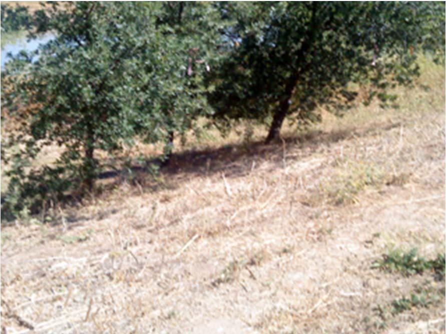
2 California s vegetated levees provide critical flood protection River Partners Pocket Levee, Sacramento River Yet riparian forests provide critical habitat and ecosystem services. How should levee trees be managed? G Fricker
3 This symposium: What can science contribute? The central scientific question: What is the impact of trees and tree roots on levee safety? Slope stabilization Seepage Key knowledge gap identified: How do tree roots actually grow in levees? CLVRP project created: Tree Root Architecture in Levees
4 Project Objectives 1. To excavate and digitally map tree root systems in levees. 2. To create 3D models of tree root architecture that will help determine the potential risks and benefits of tree roots in levees. Prologue what we know Tree root system properties Limits of methodology

5 WHERE: Surface ft provide best conditions for growth. Typically 80% of the root system is in this zone. 1 meter
6 WHAT Tree roots in many soil conditions grow horizontally more than vertically. Root architecture: combinations of 3 or 4 major woody systems Structural roots Horizontal roots Sinker roots Tap root spp./soils
7 HOW: The actual architectural pattern depends on key growth conditions: Soil moisture Aeration Mechanical impedance (soil compaction) 1 meter Soil surface Lyford 1980 Conditions are usually best in the upper part of the soil profile.

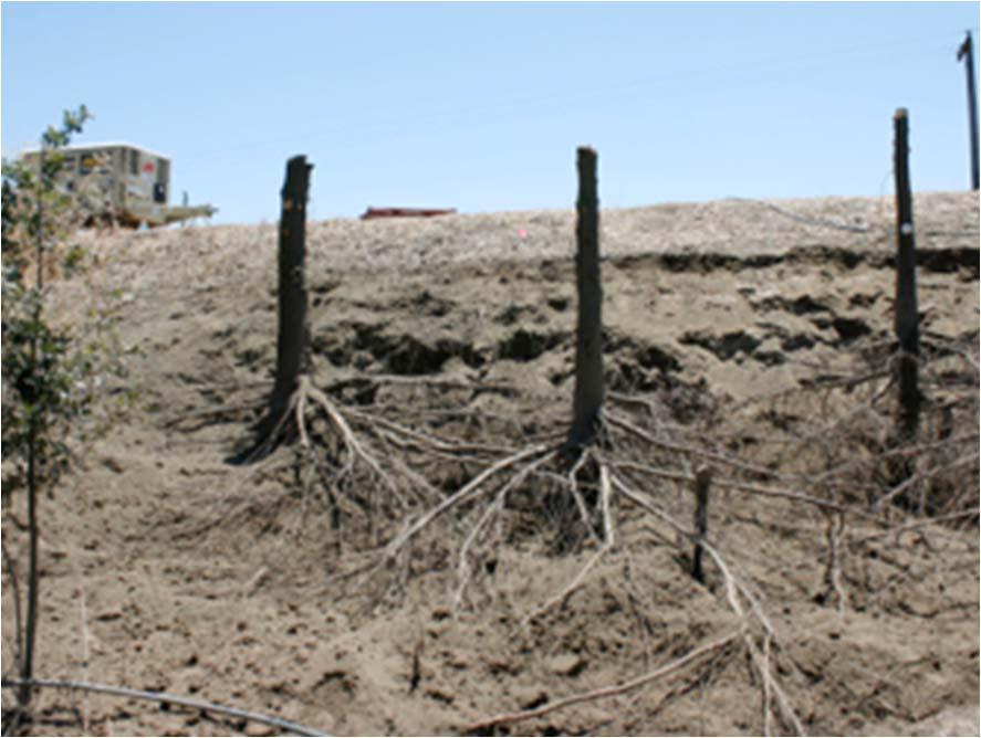
8 Trench profile mapping could show that tree roots avoid compacted soil layers in Mayhew Levee. But this method is limited, because Horizontal (ft) b.d. Depth (ft) zone with almost no roots Roots <10mm Roots mm Tree root systems are LARGE. Tree root systems in situ are SURROUNDED BY SOIL. Tree root systems are THREE DIMENSIONAL.
 1.")

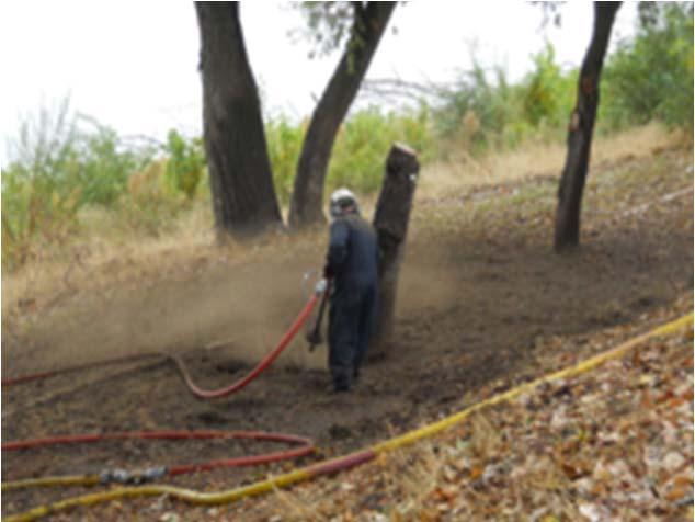
9 One way to overcome these hurdles 2. 3D laser imaging (ground based T LiDAR) 1. Air Spade excavation (pneumatic) 3. Digitized data enables precise measurement and 3D modeling of key spatial parameters.


10 Summary As you will see, architectural patterns of trees growing in sandy levees in California have distinctive, quantifiable properties. The modeling methods in Shih Ming s presentation can be widely applied. However, specific configurations of tree root systems will vary according to soil, climate and levee properties (see Caroline Zanetti s presentation). This symposium brings together many approaches and new sources of information to understand behavior of tree root systems in levees, as we will hear in presentations to follow. We all contribute to a much needed scientific knowledge base about biomechanical and geotechnical properties of trees on levees, with insights from different angles, much like the story of the blind men and the elephant.

11 Tree root growth patterns and geotechnical roles on levee Part II Methods and Applications Shih Ming Chung and Alison M. Berry


12 Fieldwork Lab processing 1. New field method for acquiring root system data 2. Data processing and model building 3. Analyzing root system patterns along levees 4. Data/models applications Quantitative model Applications
 and resolution (minimum unit) Include above ground, slope, below ground compartments Classify the data as spatial points (1D), linear connections (2D), surface patterns (3D), and")
13 Systematic approach to acquire and categorize in situ root system data Consider root system complexity and spatial attributes Use critical variables of tree root architecture to determine the range (root system extent) and resolution (minimum unit) Include above ground, slope, below ground compartments Classify the data as spatial points (1D), linear connections (2D), surface patterns (3D), and resulting thematic spatial composition
 system 3D and in-situ 15 Valley Oaks 5")
 on the water-side levee slope.")
14 1 Pneumatic excavation Pneumatic Excavation And LiDAR Scanning (PEALS) system 3D and in-situ 15 Valley Oaks 5 Cottonwoods 2 T LiDAR scanning 20 TREES IN TOTAL Most trees (18/20) on the water-side levee slope. Two control trees (flat)

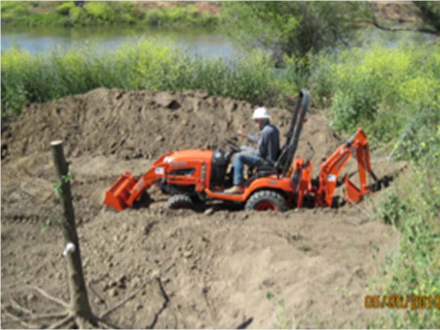
15 1 2 Pneumatic excavation (compressed air) in situ root systems 3 4


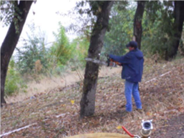
16 Ground Based Tripod LiDAR scanning
17 Process field data and acquire the resulting models Stage I: T-LiDAR point cloud data (3D) Stage II: conversion of point-cloud data - Tomographic slicing, hierarchical nested dataset, biomass model - Vectorization of polylines, topological dataset, vector model


18 Stage I Prescan: aboveground architecture and soil surface LiDAR scan after root excavation Assembly of aboveground, soil surface, and root system 4 3D LiDAR image assembly of Pocket Levee Oaks (The Pocket site, Sacramento, CA)
19 Stage II Tomographic slicing (hierarchical nested dataset) Root Biomass Model Vectorization of polylines (topological dataset) Root Vector Model
 (x1, y1, z1) (x2, y2, z2) Set up the coordinate")
20 3D Point cloud data, XYZ format (x3, y3, z3) (xn, yn, zn) (x1, y1, z1) (x2, y2, z2) Set up the coordinate system
21 Origin of the coordinate system tree trunk center at the slope surface z axis: vertical axis y axis: perpendicular to the levee Upslope Downslope x axis: parallel to the levee
22 Root biomass model Design the model based on spatial patterns: size, linkage, distribution Use root cross sectional area or diameter as the critical variable Sample the variables in virtual trench profile (2D sampling) Tomographically reconstruct the 3D hierarchical nested dataset


23 Virtual trench profile as the tomographic slices Virtual trench profile Root CSA


24 Tomographic reconstruction can use linear or radial slices Longitudinal Radial (Upslope, Downslope, Vertical)


25 2D plot R statistical program Spatial analysis format ArcGIS Spatial metrics Fragstat Data sheet for root biomass model Slice ID Root # Root CSA /Slice Root Cumulative CSA DTC n n (m 2 ) % (m)
26 Root vector model branching pattern and directionality Vectorize the point cloud data as polylines Using azimuth angle (to the north pole), zenith angle (to sky), root length, root order as the critical variables Reconstructing Topological relationship


27 Vectorizing the point cloud data Making Polylines Point-cloud data
28 Data sheet for root vector model Root ID Root order Azimuth angle Vertical angle Branching angle Root length Branching point Root Type n n Degree ( ) Degree ( ) Degree ( ) m m H, V, O
29 Data analysis Root system info Root system morphological plasticity in relation to levee geometry


30 Root system morphological plasticity in relation to levee geometry Horizontal growth pattern asymmetry Slope profile symmetry Parallel to the levee 2 nd order 3 rd 4 th 3 rd Shallow surface growth pattern Tap root 5 th Alternating growth directions 0 o 360 o

31 Root system Upslope VS. Downslope asymmetry Upslope Downslope Upslope Levee side Downslope river side Further Root Extent 5 11 Greater Biomass 5 11 Higher Root Number m Downslope side: more trees have further root extent, greater biomass, and higher root number Why are more roots on downslope side of the levee than upslope side? Bulk density 150 m
 correspond with the previous study Symmetrical and absence of taproot Root biomass radially distributes with an exponential decreasing trend Cottonwood Valley")
32 Trees growing in flat ground General patterns of root systems on a flat plain may be more symmetrical (Stokes and Mettheck, 1996) Our results (One cottonwood and one valley oak in Vernalis) correspond with the previous study Symmetrical and absence of taproot Root biomass radially distributes with an exponential decreasing trend Cottonwood Valley Oak
33 Data/Model applications 1.Below ground biomass estimation 2.Levee slope stability modeling 3.Levee slope surface erosion mapping 4.Levee vulnerability assessment
34 2. Levee slope stability modeling Virtual trench profiles can be used to locate the root system within the potential failure plane of levee slope for modeling RAR and CSA can then be used to determine Factor Of Safety (FOS) in levee slope stability model Virtual trench profile of potential failure plane RAR and CSA
35 3. Levee slope surface erosion mapping Land use and land cover mapping General geomorphology mapping Hydrological process mapping (soil plant/root system water dynamics) Resulting thematic map: Slope surface erosion map
36 4. Levee vulnerability assessment Surface process evaluation Subsurface connectivity and slope stability evaluation Potential root system occurrence evaluation Resulting vulnerability assessment map


37 Acknowledgments Collaborators Gerald Bawden, U.S. Geological Survey Sandra Bond, U.S. Geological Survey Keir Keightley, Geography, UC Davis John Lichter, Tree & Associates Vic Claassen, Soils & Revegetation, UC Davis Oliver Kreylos Jeffrey Wu Molly Ferrell Jaylee Tuil Ron Lane Student field crews: 5 seasons/4 locations RD 1000 Paul Devereux DWR Roy Kroll Dave Williams San Joaquin River National Wildlife Refuge Eric Hopson Student lab interns: Stephanie Lau Gary Bladen Hannah Stone Ryan Sresovich Joe Schlottman River Partners Stephen Sheppard Julie Rentner
Trees and Levees: How and Where Do Tree Roots Grow?
 Trees and Levees: How and Where Do Tree Roots Grow? Photo: Ed Wallace Alison M. Berry Plant Sciences Department University of California, Davis The Vegetation Challenge Symposium August 28, 2007 Tree Roots
The Effects of Woody Vegetation on Levees
 The Effects of Woody Vegetation on Levees Maureen K. Corcoran Assistant Technical Director, Water Resources Infrastructure Vicksburg, MS 26 February 2010 US Army Corps of Engineers Problem Statement What
Biotechnical engineering on alluvial riverbanks of southeastern Australia:
 Biotechnical engineering on alluvial riverbanks of southeastern Australia: A quantified model of the earth-reinforcing properties of some native riparian trees Benjamin Brougham Docker A thesis submitted
The Impact of Woody Vegetation on Levees Research Experiences from Austria
 EGU 2012 LEVEE VEGETATION RESEARCH SYMPOSIUM 2012 Sacramento, California, August 28 30, 2012 The Impact of Woody Vegetation on Levees Research Experiences from Austria Walter LAMMERANNER Institute of Soil
Donald H. Gray & F. Douglas Shields, Jr. (for the California Levee Vegetation Research Program (CLVRP) Science Team) December 05, 2011
 Science Team) December 05, 2011") Review & Summary of: Initial Research into the Effects of Woody Vegetation on Levees Volumes I-IV By US Army Corps of Engineers, Engineer Research & Development Center as reported by Corcoran et al. (2011)
Review & Summary of: Initial Research into the Effects of Woody Vegetation on Levees Volumes I-IV By US Army Corps of Engineers, Engineer Research & Development Center as reported by Corcoran et al. (2011)
GeoPlanner SM for ArcGIS : An Introduction
 GeoPlanner SM for ArcGIS : An Introduction Greg Pleiss Robert Stauder Esri UC 2014 Technical Workshop Agenda Application Overview Specific Capabilities - Configuration - Avaliable Data - Spatial Analysis
Landscape Structure and Geophysical Parameters that Control the Hydrology of Venal Pools
 Landscape Structure and Geophysical Parameters that Control the Hydrology of Venal Pools Presentation by Niall McCarten, Institute for Ecohydrology Research and Dept. of Land, Air, and Water Resources,
URBAN SOILS & SEATTLE EXAMPLES
 Class Results - Mystery Soil #1 14 12 10 8 6 4 2 0 Sandy Clay Loam Sandy Loam Silty Loam Class Results - Mystery Soil #2 6 5 4 3 2 1 0 Silty Clay Clay Loam Sandy Sandy Silty Sandy Silty Loamy Loam Clay
HISTORICAL ECOLOGY OF THE DELTA Emerging Concepts about a Spatially Complex and Temporally Dynamic System
 ITEM REMOVED DUE TO COPYRIGHT STATUS HISTORICAL ECOLOGY OF THE DELTA Emerging Concepts about a Spatially Complex and Temporally Dynamic System Robin Grossinger and Alison Whipple San Francisco Estuary
Wisconsin NRCS Direct Volume Method Bank Recession Rate Categorizations
 2 Executive Summary The City of Ramsey contracted the Anoka Conservation District to complete an inventory of riverbank condition along the entire 5.8 miles of City that border the Mississippi River. The
If you are not able to turn in your notebook see me or Dan ASAP
 Notebook Collection Collecting hard copies now OR Electronic versions using Catalyst drop box Due by 5:30 pm today Use website for link If you are not able to turn in your notebook see me or Dan ASAP URBAN
TRCA Field Staking Protocol December 2016
 Page 1 of 6 TRCA Field Staking Protocol December 2016 This Protocol describes TRCA staff s current practice for field staking the physical top of bank, the physical toe of slope, and the limit of existing
RIPARIAN HABITAT RESTORATION. Helen Swagerty Senior Restoration Biologist/Project Manager
 RIPARIAN HABITAT RESTORATION Helen Swagerty Senior Restoration Biologist/Project Manager RIVER PARTNERS: OUR HISTORY Synergy between the fields of ecological restoration and agriculture 3 Offices: Chico,
Rangeland Health (Rangeland only)
") Chapter 20 Rangeland Health (Rangeland only) 20.1 Overview This chapter covers data elements relating to Rangeland Health. Rills Infiltration and Runoff Waterflow patterns Compaction Layer Pedestals and/or
Chapter 20 Rangeland Health (Rangeland only) 20.1 Overview This chapter covers data elements relating to Rangeland Health. Rills Infiltration and Runoff Waterflow patterns Compaction Layer Pedestals and/or
Sustainable Design of Alpine Infrastructures
 105 Sustainable Design of Alpine Infrastructures Kathrin ASTE 1 and Frank LUDIN 2 1 LAAC Architects, Innsbruck/Austria kathrin.aste@laac.eu 2 LAAC Architects, Innsbruck/Austria office@laac.eu Abstract
Design Guidelines for the Enhancement and Creation of Estuarine Habitats in the Middle Reaches of the Lower Columbia River
 Design Guidelines for the Enhancement and Creation of Estuarine Habitats in the Middle Reaches of the Lower Columbia River Astoria, May 16, 2012 1 Outline I. Nature of Project/Background II. Approach to
Presentation to Parks and Open Space Advisory. Committee September 22, 2016
 Flood Planning & Preliminary Design Services for South St. Vrain Creek Restoration at Hall Ranch Presentation to Parks and Open Space Advisory Prepared for: Boulder County, Colorado Committee September
GIS Training of Undergraduates: Campus Stormwater Mapping. Joanne Logan, University of Tennessee. Gordie Bennett, University of Tennessee
 GIS Training of Undergraduates: Campus Stormwater Mapping Joanne Logan, University of Tennessee Gordie Bennett, University of Tennessee Seth Benge, University of Tennessee Tim Prather, University of Tennessee
New Tools for Land Management: A Quick Introduction to Ecological Site Descriptions
 New Tools for Land : A Quick Introduction to Ecological Site Descriptions Land management agencies have the job of managing natural resources for multiple uses in a sustainable manner. A sound understanding
STORM SEWER OUTFALLS AND CONNECTING OUTFALL CHANNELS. General Submission Requirements
 COMPLETE APPLICATION CHECKLIST Jan 2016 STORM SEWER OUTFALLS AND CONNECTING OUTFALL CHANNELS The following checklist has been compiled to assist the applicant in preparing their application for approval
Smoke Layer Height and Heat Flow through a Door
 Smoke Layer Height and Heat Flow through a Door 2018 Smoke Layer Height and Heat Flow through a Door In this tutorial you will simulate a growing fire in the corner of a 5m x 5m room. The room has a 1m
Outline. Overview of Soil Methods. Ecosystem Services in the Soil. Why care about soils? What are biological soil crusts?
 Overview of Soil Methods Outline Why do we care about soils? Biological soil crust Soil sampling methods Ecological Monitoring and Analysis (REM 357) Park Valley, UT Why care about soils? Basis for all
Mosaic of patches Agents of patch formation: Environmental constraints (Abiotic) Biotic processes Disturbances (natural and human induced)
 Biotic processes Disturbances (natural and human induced)") Landscape: Mosaic of patches Agents of patch formation: Environmental constraints (Abiotic) Biotic processes Disturbances (natural and human induced) Concepts for Quantification of a Landscape Landscape
Landscape: Mosaic of patches Agents of patch formation: Environmental constraints (Abiotic) Biotic processes Disturbances (natural and human induced) Concepts for Quantification of a Landscape Landscape
Soil Health Practices in the Landscape
 Soil Health Practices in the Landscape Salvatore Mangiafico Rutgers Cooperative Extension Environmental and Resource Management Agent In this session... Benefits of healthy soils in the landscape Plant
Levee Vegetation Research Symposium 2012 August 28, 2012
 Levee Vegetation Research Symposium 2012 August 28, 2012 (Introduction to Caroline Zanetti) Ben Carter: Dr. Caroline Zanetti, and she is joined here on the podium, in particular, to assist with the Q&A
MEMORANDUM. September 10, 2018
 September 10, 2018 MEMORANDUM TO: Chad Bird, City of Decorah FROM: Larry Weber and Dan Gilles, Iowa Flood Center, IIHR Hydroscience & Engineering COPY TO: Dana Werner, St. Paul District Corps of Engineers,
The Napa River Flood Protection Project
 The Napa River Flood Protection Project Creating Flood Protection and Restoring Geomorphic and Biological Processes Jeremy Sarrow, Napa County Flood Control & Water Conservation District June 2, 2014.
Slope Stability in Harris County
 Slope Stability in Harris County Slope Stability in Harris County Slope Stability in Harris County Overview of slope stability. Conditions, causes, and types of slope failures. HCFCD geotechnical investigation
Soil Physical Properties I: Outline
 Soil Physical Properties I: Outline Soil color See plates between pages 114 and 115 in textbook. Soil texture Soil structure Soil color Soil color provides clues to other soil properties and to soil conditions.
Using the Past to Understand the Present Emerging Lessons for Environmental Planning in the Santa Clara Valley
 Using the Past to Understand the Present -- -- -- Emerging Lessons for Environmental Planning in the Santa Clara Valley Robin Grossinger Director of the Historical Ecology Program San Francisco Estuary
Ivy Frances, CFM, CEM Chief, Floodplain Management and Insurance Branch FEMA Region One
 Ivy Frances, CFM, CEM Chief, Floodplain Management and Insurance Branch FEMA Region One Where we are Today In recent years we spent billions of dollars on disasters So many flood claims have been paid
Slope stability assessment
 Engineering manual No. 25 Updated: 03/2018 Slope stability assessment Program: FEM File: Demo_manual_25.gmk The objective of this manual is to analyse the slope stability degree (factor of safety) using
Florida Forever Conservation Needs Assessment Overview Maps
 Florida Forever Conservation Needs Assessment Overview Maps Prepared by Florida Natural Areas Inventory, The maps in this document are derived from the Florida Forever Conservation Needs Assessment, an
Chapter 3 Site Planning and Low Impact Development
 CHAPTER 3 Site Planning and Low Impact Development Chapter 3 Site Planning and Low Impact Development 3.0 Introduction The City of Charleston requires that major residential, large commercial (>1 acre),
Advanced Foundation Engineering. Introduction
 Shahrood University of Technology Department of Geotechnical Engineering Advanced Foundation Engineering Introduction Mohsen Keramati, Ph.D. Assistant Professor 1 - Detailed Course Plan Introduction (Geotechnical
APPENDIX C NATURAL RESOURCES MANAGEMENT PLAN: ACTIONS AND PRIORITIES
 APPENDIX C NATURAL RESOURCES MANAGEMENT PLAN: ACTIONS AND PRIORITIES TABLE C-1: Resource Actions and Priorities GOAL NRM-4 Objective 4.1: Restore Natural floodplain functions. Objective 4.2: Define and
ROLE OF LANDSCAPE CONSERVATION COOPERATIVES IN EVERGLADES RESTORATION
 ROLE OF LANDSCAPE CONSERVATION COOPERATIVES IN EVERGLADES RESTORATION GEER April 2017 Steve Traxler 1, Todd Hopkins 1, Beth Stys 2 1 US Fish and Wildlife Service 2 Florida Fish & Wildlife Conservation
2012 FINAL SOILS AREA 2 Envirothon Questions Answer KEY
 2012 FINAL SOILS AREA 2 Envirothon Questions Answer KEY Questions 1-6 to be answered at the soil pit: 1. Soil scientists categorize soils by drainage classes. What is the drainage class of the soil at
BAY AREA PARKS & RECREATION
 BAY AREA PARKS & RECREATION ALCATRAZ ISLAND CLIFF STABILIZATION Alcatraz Island San Francisco Bay California National Park Service Wiss Janney Elstner Associates Geologic Hazards Geotechnical Site/Civil
UNIVERSITY OF TEXAS BRACKENRIDGE TRACT THE TEAM
 UNIVERSITY OF TEXAS BRACKENRIDGE TRACT THE TEAM 1 JOHNSON FAIN / OLIN PARTNERSHIP Master Planning + Land Use Planning + Urban Design + Landscape Architecture TANIGUCHI ARCHITECTS Design Consultant + Public
The Plastic Plant. Root Architectural Responses to Limited and Altered Nutrient Availability. Bahar Aciksöz May 17 th 2018, Rome
 The Plastic Plant Root Architectural Responses to Limited and Altered Nutrient Availability Bahar Aciksöz May 17 th 2018, Rome THE FUNCTION OF A CROP STARTS WITH ITS ROOTS. AGENDA: The experiment The results
Measuring Couch Motion Accuracy with X-ray Beam Fluence
 Measuring Couch Motion Accuracy with X-ray Beam Fluence Rudi Labarbe, M.S. and Brett Nelson, M.S. IBA Particle Therapy, Belgium and Logos Systems, Scotts Valley, CA Introduction The accuracy of radiosurgery
Biotechnical streambank stabilization
 Traditional streambank stabilization Biotechnical streambank stabilization Channelization alters: shape pattern slope bed morphology cover Ecological effects: loss of riparian habitat loss of fish habitat
Lecture 8 OPENINGS &ORGANIZATION OF FORM AND SPACE
 Islamic University-Gaza Faculty of Engineering Architecture Department Principles of Architectural and Environmental Design EARC 2417 Lecture 8 OPENINGS &ORGANIZATION OF FORM AND SPACE Instructor: Dr.
Connecticut River Watershed Initiative
 Connecticut River Watershed Initiative How it came about UMASS Amherst What is the concept? What is the near-term process? How it came about 1992-2002 University of Oregon CLAMS 1998 UMass proposal to
Subject: Sea Level Rise Constraints and Opportunities for India Basin
 Memorandum To: Monica Melkesian, Build Inc Cc: From: Leslie Lazarotti lazarotti@wra-cacom Ext 1300 Subject: Sea Level Rise Constraints and Opportunities for Date: July 8, 2015 The impetus for this study
WELCOME! Four Corners and Upper Rio Grande Vulnerability Assessment Webinar Series
 WELCOME! Four Corners and Upper Rio Grande Vulnerability Assessment Webinar Series Phone audio: Dial: 866-620-8138; Passcode: 5952203# Mute your phone and turn off computer speakers (prevents echo issue).
COMPLIANCE CHECKLIST HILLSIDE RESIDENTIAL DESIGN GUIDELINES MANUAL
 COMPLIANCE CHECKLIST HILLSIDE RESIDENTIAL DESIGN GUIDELINES MANUAL The following checklist summarizes development guidelines and standards. See the appropriate section for a complete explanation of the
Aim to Reclaim. Introduction
 Aim to Reclaim Introduction Welcome to Aim to Reclaim, a virtual lab that takes you inside the world of copper mining. You may remember that the mining process involves four important phases: Exploration,
Water Resources and Policy Initiatives CSU Campus Water Use Calculations Standard Operating Procedures February 26, 2016
 Water Resources and Policy Initiatives CSU Campus Water Use Calculations Standard Operating Procedures February 26, 2016 Project Background California State University (CSU) campuses face a challenge in
Impacts of Porous Pavements on Soil Environment and Street Tree Growth. Justin Morgenroth New Zealand School of Forestry University of Canterbury
 Impacts of Porous Pavements on Soil Environment and Street Tree Growth Justin Morgenroth New Zealand School of Forestry University of Canterbury Impervious Urban Surfaces Impervious Urban Surfaces Disrupt
Lecture: Landscape Ecology
 Borderland: Border Landscapes Across Europe 2013 Lecture: Landscape Ecology Dr Iwona Markuszewska Department of Landscape Ecology iwmark@amu.edu.pl Presentation schedule: Landscape ecology as a scientific
Unit II Soil Management
 Unit II Soil Management Lesson 2: Using Soil Survey Manuals Soil survey manuals provide useful information for grassland management. Soil scientists evaluate the soil for chemical and physical properties,
ATTACHMENT A BIORETENTION SOIL SPECIFICATION
 1.00 BIORETENTION SOIL ATTACHMENT A BIORETENTION SOIL SPECIFICATION Bioretention soil shall achieve an initial infiltration rate of at least 8-inch per hour nor more than 20 inches per hour in situ and
Thermal Response Test to Assess Adhesive Bond Quality in a Microwave Circulator
 Thermal Response Test to Assess Adhesive Bond Quality in a Microwave Circulator E. C. Johnson and Y. M. Kim The Aerospace Corporation, Los Angeles, CA 90009 14th International Symposium on Nondestructive
The Landscape Project. New Jersey Department of Environmental Protection Division of Fish and Wildlife Endangered and Nongame Species Program
 The Landscape Project New Jersey Department of Environmental Protection Division of Fish and Wildlife Endangered and Nongame Species Program New Jersey is One of the smallest states in the country Yet
Restoration in the Sky Islands:
 Restoration in the Sky Islands: Bringing volunteers, landowners, practitioners and agencies together to benefit wildlife and habitats in a global biodiversity hotspot Sky Island Alliance Dedicated to the
Great Lakes Conservation Blueprint for Terrestrial Biodiversity on the Canadian Shield
 Great Lakes Conservation Blueprint for Terrestrial Biodiversity on the Canadian Shield Bonnie L. Henson 1, Kara E. Brodribb 2 and John L. Riley 3 1 Ontario Ministry of Natural Resources 2,3 The Nature
CHAPTER 8 SLOPE STABILITY ANALYSIS
 TM 5-818-1 / AFM 88-3. Chap. 7 CHAPTER 8 SLOPE STABILITY ANALYSIS 8-1. General. This chapter is concerned with characteristics and critical aspects of the stability of excavation slopes; methods of designing
Montana Stream Permitting
 Montana Stream Permitting A Guide for Conservation District Supervisors and Others Conservation Districts Bureau Montana Department of Natural Resources and Conservation June 2001 CONTRIBUTORS Committee
Stormwater Standards. Clackamas County Service District No. 1. Planting Guide for Buffers
 Stormwater Standards Clackamas County Service District No. 1 APPENDIX B Planting Guide for Buffers Table of Contents Appendix B - Planting Guide for Buffers... Page B.1 General... 1 B.1.1 Introduction...
Reducing the likelihood of giant
 Reducing the likelihood of giant reed d(arundo d donax) ) reinvasion i How does light attenuation affect giant reed establishment? Kai Palenscar Dr. Jodie Holt October 5, 2011 Overview Introduction: riparian
The Salt Marsh Advancement Zone Assessment of Connecticut
 The Salt Marsh Advancement Zone Assessment of Connecticut Front cover image: Salt marsh advancement zones in Stratford, CT from the Comprehensive Map Book of Stratford, CT. Table of Contents Introduction...
Working with Partners to Manage Recreation Sites. Dave Samson California Department of Water Resources
 Working with Partners to Manage Recreation Sites Dave Samson California Department of Water Resources FERC Recreation Workshop, Ontario, CA February 17-19, 2015 CALIFORNIA STATE WATER PROJECT OROVILLE
Chapter 8 REMEDIAL MEASURES 8.1 FACETS IN HAZARD CATEGORY
 Chapter 8 REMEDIAL MEASURES 8.1 FACETS IN HAZARD CATEGORY Stabilization of rock slope happens when the driving force acting on a potentially unstable rock slope is reduced, while the resisting force increases
URS Australia ADDENDUM. Caval Ridge Project Soil Survey and Land Resource Assessment Report
 URS Australia ADDENDUM Caval Ridge Project Soil Survey and Land Resource Assessment Report September 2009 ADDENDUM Addendum to the Caval Ridge Project Soil Survey and Land Resource Assessment Report 2009,
LANDSCAPE ARCHITECTURAL DESIGN: PROCESS, PREDILECTIONS, AND PRIORITIES
 LANDSCAPE ARCHITECTURAL DESIGN: PROCESS, PREDILECTIONS, AND PRIORITIES ECOLOGICAL DESIGN IN THE SOUTHEAST APRIL 23, 2014 DR. JON CALABRIA, ASLA ASSISTANT PROFESSOR, COLLEGE OF ENVIRONMENT AND DESIGN, UNIVERSITY
VEGETATED SLOPE STABILIZATION DESCRIPTION APPLICABILITY. Advantages
 4.2-d VEGETATED SLOPE STABILIZATION Alternative Names: Willow Wattles, Live Bundles, Fascines, Live Staking, Joint Planting, Branch Packing, Brush Layering, and Brush Matting DESCRIPTION Vegetated slope
Analysis of Pullout Resistance of Soil-Nailing in Lateritic Soil
 Analysis of Pullout Resistance of Soil-Nailing in Lateritic Soil B,L.A. Isaka 1, B.C. Madushanka 1 and N.H. Priyankara 1 1 Department of Civil and Environmental Engineering Faculty of Engineering University
UBC Social Ecological Economic Development Studies (SEEDS) Sustainability Program. Student Research Report
 Sustainability Program. Student Research Report") UBC Social Ecological Economic Development Studies (SEEDS) Sustainability Program Student Research Report UBC Botanical Gardens Mapping Manual Amanda Leslie, Emma Cunningham, Gary Pinneo, Lauren Tekano,
UBC Social Ecological Economic Development Studies (SEEDS) Sustainability Program Student Research Report UBC Botanical Gardens Mapping Manual Amanda Leslie, Emma Cunningham, Gary Pinneo, Lauren Tekano,
Each course is worth 1 American Institute of Architects CEU/HSW.
 Each course is worth 1 American Institute of Architects CEU/HSW. Introduction to Mobile Mapping Attendees will learn the basics of mobile mapping including history, trends, components, and uses. This course
Riparian Ecology and Plant Identification Ventura River and Casitas Springs Community Center Nov 7-8, 2007
 The CNPS Plant Science Training Program is proud to present a two-day Riparian workshop, at the, Casitas Springs (between Ventura and Ojai) Target audience: Professional and student botanists, biologists,
Soil Maps for Production Agriculture. Jarrod O. Miller, Extension Agronomist
 Soil Maps for Production Agriculture Jarrod O. Miller, Extension Agronomist Origination of Soil Mapping Originally mapped by Division of Soils Federal Bureau of Soils Soil Conservation Service (SCS) started
Rangeland Interagency Ecological. Dennis W. Thompson National Range and Grazing Lands Ecologist USDA Natural Resources Conservation Service
 Rangeland Interagency Ecological Site Manual Dennis W. Thompson p National Range and Grazing Lands Ecologist USDA Natural Resources Conservation Service Rangeland Interagency Ecological Site Manual (RIESM)
Design and Installation of Embedded Culverts
 Kamloops March 12, 2002 Pilot 2 Design and Installation of Embedded Culverts Part 2: Design 1 2 Part 2: Design 6 Main Topics 1. Evaluation of site suitability 2. Detailed streambed profile 3. Sizing the
7.0 SOCIAL, ECONOMIC, AND ENVIRONMENTAL ISSUES
 7.0 SOCIAL, ECONOMIC, AND ENVIRONMENTAL ISSUES The following list of social, economic, and environmental issues have been identified based on a preliminary inventory of resources in the project area, an
AN ASSESSMENT OF STRENGHT PROPERTIES OF. Diti Hengchaovanich and Nimal S. Nilaweera 1
 ANASSESSMENTOFSTRENGHTPROPERTIESOF VETIVERGRASSROOTSINRELATIONTOSLOPE STABILIZATION DitiHengchaovanichandNimalS.Nilaweera 1 Introduction Vetivergrass(Vetiveriazizanioides)hasbeenutilizedto reducesoilerosioninmanycountriesthroughouttheworldfora
Alternative Names: Erosion Control Matting, Erosion Control Netting, Rolled Erosion Control Products (RECP)
") 4.5-s EROSION CONTROL BLANKET SYSTEM Alternative Names: Erosion Control Matting, Erosion Control Netting, Rolled Erosion Control Products (RECP) DESCRIPTION Erosion control blanket systems are woven or
4.5-s EROSION CONTROL BLANKET SYSTEM Alternative Names: Erosion Control Matting, Erosion Control Netting, Rolled Erosion Control Products (RECP) DESCRIPTION Erosion control blanket systems are woven or
Controlling Creasing & Folding in the Box Forming Process
 Controlling Creasing & Folding in the Box Forming Process Beta Industries introduces the FIRST Quality Control tool for the folding carton industry. The BetaFold Crease & Fold Analyzer System is designed
Learning Objectives Part 1. Chapter 4 Soil Physical Properties. Soil Physical Properties. Color. Physical properties part 1
 Learning Objectives Part 1 Chapter 4 Soil Physical Properties Know what color tells you about a soil Describe the concept of soil texture and its importance Use the textural triangle to determine a soil
Level 1: GIS-based Desktop Assessments. Meghan Burns, Landscape Ecologist
 Level 1: GIS-based Desktop Assessments Meghan Burns, Landscape Ecologist EPA three-tier framework WETLAND AND RIPARIAN MAPPING LEVEL 1 LANDSCAPE ASSESSMENT WETLAND LANDSCAPE PROFILES LEVEL 2 RAPID ASSESSMENT
The Soils That We Classify
 The Soils That We Classify 2 Abstract Soil is the natural medium for the growth of land plants, whether or not it has discernible soil horizons. People consider soil important because it supports plants
EFFECT OF RELICT JOINTS IN RAIN INDUCED SLOPE FAILURES IN RESIDUAL SOIL
 EFFECT OF RELICT JOINTS IN RAIN INDUCED SLOPE FAILURES IN RESIDUAL SOIL Neethimappiriya Tharmalingam, Student (Email: neethi_26@yahoo.com) N.W.H. Lakshamana, Student (Email: hansaka8888@yahoo.com) R.D.T.B.
Long-range Ultrasonic Non-destructive Testing of Fuel Tanks
 ECNDT 2006 - Fr.2.2.4 Long-range Ultrasonic Non-destructive Testing of Fuel Tanks Liudas MAŽEIKA, Rymantas KAŽYS, Renaldas RAIŠUTIS, Andriejus DEMČENKO, Reimondas ŠLITERIS Ultrasound Institute, Kaunas
Notice of Preparation of an Environmental Impact Report and Scoping Meeting for the Canyon Lane Roadway Improvements Development Project
 of an Environmental Impact Report and Scoping Meeting for the As the Lead Agency, the County of San Mateo (County) will prepare an Environmental Impact Report (EIR) for the (project), and would like your
Geodesign. Presenter: Shannon McElvaney
 Geodesign Presenter: Shannon McElvaney Overview Drivers of change What is geodesign? Why is geodesign important? Who is doing it? How can you get started? Population Growth and Urbanization Population
The use of willows in the rivers of the Bay of Plenty region, New Zealand
 The use of willows in the rivers of the Bay of Plenty region, New Zealand Presenters Tony Dunlop Principal Works Engineer Bay of Plenty Regional Council and Gary Williams, Waterscape Consultant Engineer
Township of Adjala-Tosorontio Official Plan Review. Natural Heritage
 Township of Adjala-Tosorontio Official Plan Review 13 Natural Heritage Introduction What is an Official Plan? An official plan is a municipal policy document which sets out the community s vision and strategies
Road Ecology in Practice: Building Resiliency of Urban Ecosystems through Informed Road Network Planning
 Road Ecology in Practice: Building Resiliency of Urban Ecosystems through Informed Road Network Planning Outline What is road ecology? Why is road ecology important? TRCA and road ecology application Peel
Using AutoCAD Civil 3D and ESRI ArcGIS to meet LEED-ND (Neighborhood Development) Requirements NDIA O Brien & Gere. All Rights Reserved.
 Requirements NDIA O Brien & Gere. All Rights Reserved.") Using AutoCAD Civil 3D and ESRI ArcGIS to meet LEED-ND (Neighborhood Development) Requirements NDIA 12457 1 Using AutoCAD Civil 3D and ESRI ArcGIS to meet LEED-ND (Neighborhood Development) Requirements
Using AutoCAD Civil 3D and ESRI ArcGIS to meet LEED-ND (Neighborhood Development) Requirements NDIA 12457 1 Using AutoCAD Civil 3D and ESRI ArcGIS to meet LEED-ND (Neighborhood Development) Requirements
Lessons Learned from Katrina and Reducing Vulnerability Fall 2011
 Page 1 of 9 TIDE-1220 Tulane University New Orleans & Hurricanes Prof. Stephen A. Nelson Lessons Learned from Katrina and Reducing Vulnerability Fall 2011 This document last updated on 21-Sep-2011. Why
6Natural. Environment Development Permit Guidelines
 6Natural Bylaw 2600-2016, being "Official Community Plan Bylaw, 2016" Schedule "A" CITY OF ABBOTSFORD OFFICIAL COMMUNITY PLAN Environment Development Permit Guidelines Part V - 6-1 Area Subdivision or
History as a source for understanding todays landscape Ingrid Sarlöv Herlin, SLU, Sweden
 COMBINING SCIENTIFIC EXPERTISE WITH PARTICIPATION: THE CHALLENGE OF THE EUROPEAN LANDSCAPE CONVENTION 28-29 April 2014, Université Libre de Bruxelles (ULB), History as a source for understanding todays
Landscape Ecology and EA in Ontario:
 Landscape Ecology and EA in Ontario: Bridging Gaps in Biodiversity Assessment Christina Rehbein, Dr. Scott Mitchell & Dr. Mike Brklacich Carleton University OAIA 2017 18 October 2017 Biodiversity and EA
This definition is from the Soil Science Glossary (Soil Science Society of America).
.") What is Soil? This definition is from the Soil Science Glossary (Soil Science Society of America). soil - (i) The unconsolidated mineral or organic material on the immediate surface of the earth that serves
What is Soil? This definition is from the Soil Science Glossary (Soil Science Society of America). soil - (i) The unconsolidated mineral or organic material on the immediate surface of the earth that serves
Analysis of the stability of slopes reinforced by roots
 Design and Nature V 189 Analysis of the stability of slopes reinforced by roots F. Gentile1, G. Elia2 & R. Elia1 1 Department of Engineering and Management of the Agricultural, Livestock and Forest Systems
Hydrologic Assessment of using Low Impact Development to Mitigate the Impacts of Climate Change. Chris Jensen, AScT Master of Science Thesis
 Hydrologic Assessment of using Low Impact Development to Mitigate the Impacts of Climate Change Chris Jensen, AScT Master of Science Thesis Bowker Creek Initiative April 12, 2012 Outline 1. Future Impacts
Request for an Exception to the Napa County Road and Street Standards
 F Request for an Exception to the Napa County Road and Street Standards Shed Creek Winery Use Permit P16-327 and Use Permit Exception to the Conservation Regulations P17-178 Planning Commission Hearing
CMG GardenNotes #659 Understanding Tree Roots. Functions of Tree Roots. Support\anchorage
 CMG GardenNotes #659 Understanding Tree Roots Outline: Functions of Tree Roots, page 1 Describing Tree Roots, page 2 Conditions That Can Adversely Affect Roots, page 4 Other Common Root Issues, page 5
The Toe Wood Structure
 The Toe Wood Structure by Dave Rosgen Objectives: Enhance fish habitat/food chains Stabilize streambanks Maintain a low width/depth ratio Provide a more natural appearance & improve visual values Be compatible