Vermont Soil and Land Judging Manual
|
|
|
- Claude Andrews
- 6 years ago
- Views:
Transcription

1 Vermont Soil and Land Judging Manual Revised October 5, 2012
2 Table of Contents Introduction 1 Factors of Soil Formation 1 Parent Material 1 Climate 2 Plant and Animal Life 3 Relief (or Topography) 3 Time 3 Processes of Soil Formation 3 I. Evaluating the Physical Features of the Soil and Site 4 The Soil Profile 4 Soil Texture 5 Parent Material 7 Natural Soil Drainage Classes 8 a. Seasonal High Water Table 8 b. Soil Drainage Classes 9 Depth to Bedrock 10 Root Limiting Layers 10 Soil Permeability 11 Surface Stones and Rock Outcrops 11 Slope 12 How to make a slope finder 12 How to use a slope finder 12 Surface Runoff 13 II. Evaluating Soil Physical Features to determine Land Use Potential 14 Agricultural Potential 14 Woodland Potential 14 Site Suitability for Land Uses 15 Overcoming Site Limitations 16 Land Treatments and Management Practices to overcome Site Limitations 16 III. Using the Scantron scorecard 17 IV. Scoresheet for Evaluating Soil and Land V. Slope Finder 21 With input from the Vermont Agricultural Teachers Association, edited by: Thomas Villars, Soil Resource Specialist USDA Natural Resources Conservation Service 28 Farmvu Drive White River Junction, VT , x. 24 Thomas.villars@vt.usda.gov The picture on the front cover is of a painting by Reed Prescott of Lincoln, VT. More information can be accessed at
3 Introduction How you define and characterize soil depends on your background. Farmers and foresters view soil as a medium for plant growth. Engineers view soils as areas to build on. But a geologist just might look at everything above bedrock as "overburden" and not give it a second thought! The characteristics that make some soils highly desirable for agriculture can also make them desirable for development. Engineers are concerned with many of the same physical characteristics that interest farmers: soil drainage, texture, depth, slope, and position in the landscape. Because of increasing land conversion to development, the loss of highly productive agricultural land is an issue causing concern in many states and communities. When assessing the characteristics of a large parcel of land, it can be helpful to divide the parcel into smaller pieces that can be evaluated separately. A 100 acre parcel may have 60 acres of open land and 40 acres of woodland. The 60 acres of open land could be split into 20 acres of steep pasture, 20 acres of gently sloping hayland, and 20 acres of nearly level cropland. The woodland could be split into 10 acres of shrubby wetland, 20 acres of sloping hardwoods, and 10 acres of steep softwoods. Each of these pieces can be evaluated for their potential for different uses. This is what soil and land judging is all about: judging a parcel of land and its soils for their potential for agriculture, forestry, and development. In the Agricultural and Natural Resources Education Soil and Land Judging Skills and Career Development Event, a land unit to be judged will be clearly identified. The soil is the factor we will evaluate most intensively. In this competition, land will be evaluated primarily from the agricultural, forestry, and engineering standpoint. This guide can also serve as a primer on soils for other curricula and skills events, including the Vermont Envirothon ( ). Factors of Soil Formation The formation of the soils in Vermont involves many factors. The following excerpt from the Windham County Soil Survey 1 describes these factors in detail to provide some background for this manual. Soil forms through the interaction of five major factors: 1) the physical, chemical, and mineral composition of the parent material; 2) the climate under which soil material has accumulated and existed since accumulation; 3) the plant and animal life on and in the soil; 4) the lay of the land or its relief or topography; and 5) the length of time the processes of soil formation have acted on the parent material. Parent Material Parent material is the unconsolidated material in which soils form. Most of the different parent materials in Vermont are related to the glaciers that covered New England about 12,000 years ago. Some of these materials were also affected by subsequent actions of wind and water. Parent material determines the baseline chemical and physical composition of the soil. Even though most of the parent material in Vermont is of similar glacial origin, the properties can vary greatly, 1 Soil Survey of Windham County, Vermont, pages
4 sometimes within small areas. General categories of parent material in the state include glacial till, outwash deposits, lacustrine deposits, alluvial deposits, and organic deposits. Glacial till was deposited directly by glaciers. It is a mixture of particles varying in size and shape. The coarse sand, gravel, cobbles, and stones so common in glacial till have not been worn smooth by flowing water like coarse fragment in outwash deposits thus on close examination, these fragments have sharp, angular edges and corners. Glacial till can vary in acidity, depending on whether there is limestone bedrock in the area or not. It is usually loamy textured, although in some places, it can be silty or sandy. Many soils in Vermont are formed in glacial till, including the Vermont State Soil - the Tunbridge soil. Glacial outwash deposits were deposited by running glacial meltwater. Most of these deposits are sandy or gravelly, especially in the lower part of the soil profile, and are located along streams and rivers above the level of the floodplain. Outwash deposits generally consist of layers (or strata) of soil particles of similar size, such as strata of sand or gravel. Windsor soils are typical of soils formed in sandy outwash deposits. Alluvial deposits are material deposited by floodwater of streams in recent times. These deposits are found directly beside stream channels. They range in texture from loamy and silty to sandy, depending in part on the speed of the floodwater that deposited the material. Alluvial deposits are typically stratified. Hadley soils are formed in alluvial deposits. Lacustrine deposits were deposited in still or ponded water in glacial lakes that were formed when the glacier blocked river and stream valleys. In this still water environment, finer soil particles such as silt and clay settled to the bottom. When the lakes eventually drained, the lacustrine deposits remained. Soils that formed in lacustrine deposits typically have clayey or silty textures, with very few sand particles or gravel. Many soils in the Champlain Valley, including the Vergennes soil, are formed in clayey lacustrine deposits. Organic deposits consist primarily of slightly to well decomposed plant material. In most places, long periods of saturation over many years has been a factor in the build-up of these deposits, which are typically in depressional areas. Some of the depressional areas actually began as ponds. The ponds were surrounded by grasses and sedges, which died and started accumulating in the water. The plant remains eventually closed in the edges of the ponds. Water-tolerant trees also grew in and around the ponds and the remains of the trees also accumulated in the water. Eventually, the ponds totally filled in with organic deposits. Bucksport soils are formed in organic deposits more than 50 inches thick. Climate Climate affects soils in many ways. It can influence the kind of plant and animal life in the soil. Through its affect on soil temperature and moisture conditions, it influences the rate of chemical and biological activity in the soil. In colder soils and in soils saturated for long periods, the level of biological activity is low and organic matter accumulates. Chemical processes occur at a faster rate in warmer soils. The climate in Vermont differs from place to place, depending on elevation and physiographic region. There are three different soil temperature regimes recognized in the state: 1) the mesic soil temperature regime in warmer river valleys and the Champlain Valley, 2) the frigid soil temperature 2
5 regime in most of the state, and 3) the cryic soil temperature regime on the highest mountains in the state, generally above 2500 feet. Plant and Animal Life Plants are one of the principal types of organisms influencing soil formation, but bacteria, fungi, earthworms, and human activities are also very important. Plants add organic matter and nitrogen and other nutrients to the soil. The kind of organic material in the soil depends on the plants growing on the soil. For example, organic material from spruce and hemlock trees varies substantially from the organic material from native grasses found in the Great Plains states. Plant remains accumulate on the surface, decay, and become incorporated into the soil with the help of various soil organisms. Plant roots provide channels for the downward movement of water through the soil and add organic matter to the soil as they decay. Soil bacteria help to break down the organic matter and release plant nutrients. Relief or Topography Relief, topography, or the lay of the land, has a marked influence on soil formation through its influence on drainage, erosion, plant cover, and soil temperature. Relief is measured by the percent slope. Slopes in Vermont range from a nearly level 0% to very steep slopes well over 70%. Relief influences the formation of soils by affecting runoff and drainage. On steeper slopes, runoff is greatest and the soils are better drained. On flatter slopes, water drains off soils more slowly. In low-lying depressional areas, the soils are often temporarily ponded. Water and air move freely through soils that are well drained and slowly through soils that are poorly drained. Through its effect on aeration and the oxidation-reduction status of minerals in the soil, drainage influences the color of the soil. Well-aerated soils are brightly colored reddish-brown, because the iron and manganese compounds have been oxidized and have a rusty color. Poorly aerated soils are dull gray and mottled, due to iron and manganese being reduced. The wettest soils smell of hydrogen sulfide gas (with a rotten egg smell) because sulfur has also been reduced. Time The differences in time that the parent material has been in place are commonly reflected in the degree of development in the soil profile. Hundreds, if not thousands, of years may be needed for the processes of soil formation to develop distinct horizons from the parent material. Some soils develop into separate layers rapidly while others develop slowly. Sandy soils on outwash deposits, for example, have been in place long enough to develop distinct soil horizons and the sandy texture also helps to show horizons more clearly. Alluvial deposits on floodplains do not typically have distinct horizons. Processes of Soil Formation The most important soil forming processes are the accumulation and distribution of organic matter in the topsoil and the chemical weathering of primary minerals into silicate clay minerals. Other important soil forming processes include 1) chemical reactions such as oxidation, reduction, and hydration, and 2) physical weathering and breakdown of rock fragments into finer particles. 3
6 Some processes modify, retard, or reverse the effects of soil forming processes. The most important of these are 1) the mixing of soil by windthrow, animal activities like burrowing, or frost action, and 2) the deposition of fresh soil material from flooding, landslides, or other mechanisms. Organic matter can accumulate to some degree in all soils in Vermont. The dark color of the surface layer is an indication of organic matter accumulation. Soils formed in alluvial deposits often have enough organic matter to noticeably darken the color to a depth of 24 inches or more. In many soils, chemical changes have been important in horizon differentiation. In some soils, iron compounds have moved down through the soil, forming metal-organic oxides. They are generally precipitated in the subsoil as iron oxides, which color the subsoil reddish or brownish Mottling and gleying result from reduction in the soil horizons. Mechanical breakdown is another soil process. This is mainly freezing and thawing. Glacial till soils have angular coarse fragments, while outwash soils have rounded coarse fragments, due to their being tumbled down waterways during glacial melting. In conclusion, all of our soils are still evolving and changing. These changes may be undetectable in a person's lifetime or, if a soil is mismanaged or abused, remarkable changes can be seen in a single growing season. To judge a parcel of land we must evaluate the natural features according to intended uses. The features we evaluate can then be used to determine if the intended use is ecologically feasible and economical. Soil and land judging requires careful attention to soil texture, color, drainage conditions, depth, permeability, stoniness and rockiness, slope, and surface runoff. I. Evaluating the Physical Features of the Soil The Soil Profile Soils are made of distinct layers called horizons (see figure 1.) The horizon closest to the soil surface is referred to as the A horizon. It is turned over in a normal plowing operation, which is usually 6-8 deep. In the Soil and Land Judging Contest, this layer is referred to as the topsoil. The horizon below the plow layer is referred to as the subsoil in the Contest. It is also known as the B horizon. The C horizon is commonly referred to as the substratum and is relatively undeveloped parent material, with few, if any, roots. Its upper boundary is generally between 18 and 36 inches below the surface. 4

7 The makeup of the soil profile is important in assessing land use potential. It can give evidence of a seasonal high water table. It will clearly indicate the depth to impervious layers or bedrock. In addition, it can give an indication of internal soil drainage and organic matter content. Figure 1: A soil profile, showing the basic horizons. The upper layers (O and A horizons) in this unplowed soil are darker in color because of their high organic matter content. In a plowed soil, the O horizon is mixed into the A horizon. The presence and variation of soil horizons are used to help differentiate one soil type from another. Soil Texture Soil texture is defined as "the relative proportions of the various sizes of soil particles in a soil." Texture is determined after taking out any larger rock fragments in the soil, such as stones, cobbles and gravel. The soil particles measured for texture are classified by their size: sand (largest), silt (intermediate), and clay (smallest size particle). Texture influences the moisture holding capacity, nutrient availability and potential fertility, permeability, and erosion potential of a soil. A lab test called a Particle Size Distribution Analysis (PSDA) can give very accurate percentages of sand, silt, and clay in a dried soil sample. The USDA Natural Resources Conservation Service (NRCS) uses a "Textural Triangle" (Figure 2) to determine soil textures by the percentages of sand, silt, and clay. 5
8 Figure 2: USDA NRCS Textural Triangle (bold lines show texture groups for Soil and Land Judging Contest) In Soil and Land judging, texture is determined by feel - moistening the soil and rubbing a small amount between the thumb and fingers. The relative proportions of sand, silt, and clay can be estimated to arrive at a general textural class. Anyone judging soil texture must learn to trust their sense of feel. Many soil scientists are able to accurately determine texture with only a pinch of soil. Becoming adept at this technique requires practice using soils of known texture. This is one soil and land judging skill where experience counts. The general soil textural classifications are shown in the textural triangle in Figure 2. In the Soil and Land Judging event, two textural determinations will be made: the topsoil texture and the subsoil texture - both determined by feel. The textural groups used on the scoresheet are as follows: Sandy: Sandy soils feel gritty and do not hold together when moist. Textures included in this category are loamy sand and sand. Occasionally in soils, layers of gravel texture may be stratified in between the sand layers. They are droughty (low moisture holding capacity) and permit water and air to move through rapidly. With ideal rainfall, or irrigation, these soils are well suited for farming. Where drainage is good and pollution of ground water supplied is not a potential threat, these textures are favorable for septic tank filter fields. Loamy and Silty: Loamy and silty soils contain moderate proportions of sand, silt, and clay. Textures included in this class are loam, sandy loam, silt loam, and silt. When rubbed between the fingers, loamy soils feel slightly gritty, but not sticky. Silty soils feel relatively smooth, but also not sticky. A ribbon does not form very well when a moistened sample is rubbed out between the fingers and thumb. The ribbon may attain a length of an inch or two of unsupported material, but then will break under its weight. These textures have good moisture holding capacity and good fertility. They are typically the most productive agricultural soils. If these soils are well drained, have good structure, and do not have hardpan or bedrock at a shallow or moderate depth, septic tank filter fields often function well in them. 6
9 Clayey: Clayey soils are those containing at least 27 percent clay (with the exception of the sandy clay loam, which contains only 20 percent clay). Textures included in this class are sandy clay, sandy clay loam, clay loam, silty clay, silty clay loam, and clay. For clayey soils, when moist samples are rubbed between the fingers and thumb, a long ribbon can be formed. The more clay in the sample, the stickier and stiffer it will feel, and the longer and more flexible the ribbon will be. Because of their finer pores, clayey soils do not normally allow water to move through as rapidly as silty, loamy or sandy soils. Their slow permeability generally means severe limitations for septic tank filter fields. These textures have good moisture holding capacity and fertility levels. Very clayey soils can actually be droughty because their fine pores hold water molecules very tightly. Parent Material The majority of Vermont soils are derived from different parent materials left behind after the last glacier. For the Soil and Land Judging contest, the contestant must determine the parent material category that best matches the soil at each site. The parent material determination will be based on the soil in the pit and surrounding landforms, unless otherwise stated. (At some pits, it s possible the proctor will instruct you to judge the parent material based on the soil in the texture buckets.) The four general categories are: Glacial till: Mineral material deposited by glaciers consisting of sand, clay, silt, stones, and boulders in somewhat even proportions. Most commonly found in upland areas. There is no stratification of the materials. They sometimes have a dense compacted layer in lower subsoil. Rock fragments typically have sharp angular edges. Glacial outwash: Mineral materials deposited by the glacial meltwater. These materials are often found in stratified layers. Sand, gravel, and thin silt lenses are common in the soil profile. Subsoil textures are sandy, often with much gravel content. (Note: although this is true of natural soil profiles in glacial outwash, texture samples in the buckets may not always come from the same parent material as the site, so it is possible that a site could have loamy, silty or clayey textures even though the parent material is glacial outwash.) Most stones and gravel have rounded edges from being rolled along a streambed by moving water. This parent material is commonly found on terraces along rivers and occasionally in upland areas. These sites are often used for sand and gravel extraction. Alluvial deposits: This parent material is associated with soils on floodplains. An area with this type of parent material may flood several times annually or only during times of unusually high water every decade or two. The soils formed in alluvium on floodplains often have indistinct profiles. The soil texture is silty, loamy or sandy but almost never clayey. (Note: although this is true of natural soil profiles in alluvial deposits, texture samples in the buckets may not always come from the same parent material as the site, so it is possible that a site could have clayey textures even though the parent material is alluvial deposits.) Dark colored horizons with high organic matter content are sometimes found at various depths in the profile. These are buried topsoil layers, indicating an older surface layer that's been buried by more recent alluvial deposits by flooding. It is important to recognize the stratification and landscape position along streams that is characteristic of this parent material. Lacustrine deposits: This type of parent material is consistently associated with clayey and silty soils with low sand content. The soils formed in this material are typically deep and 7
10 uniform in texture. This parent material typically has very few stones in the soil or on the surface. It is found in areas that were under water during part of the last ice age. The two main areas of this material are the Champlain Valley and the Connecticut River Valley, but it is also found along the Winooski River and the White River and many other areas. Organic deposits are another type of parent material, but because they are typically found in very wet, water-logged soils, they are not included in the Soil and Land Judging contest for practical reasons. Natural Soil Drainage Classes a. Seasonal High Water Table No water table in a soil is truly constant at any one depth. Drought, heavy rain, plant uptake of water, and many other factors affect water table levels - often by several feet. A seasonal water table will fluctuate substantially during a normal year. Note, too, that the seasonal high water table is not the same as the groundwater table that water wells are bored into groundwater wells typically go deep down into bedrock. They re often over a hundred feet deep. For the Soil and Land Judging contest, a seasonal high water table is defined as the highest level in a freshly dug observation hole at which water stands during the year and hydrostatic pressure in the surrounding soil has come to equilibrium. The depth of the seasonal high water table is based on the shallowest depth in which redoximorphic features occur in the soil profile. The presence of redoximorphic features in a soil profile generally indicates that a seasonal high water table is present in the soil at some time during the year. Bright reddish-orange, yellowish-orange, and grayish splotches that strongly contrast with the dominant soil color are typical redoximorphic features in Vermont soils. Small splotches with distinctly gray colors interspersed within the dominant browner soil colors are an excellent indication of a seasonal high water table occurring at that depth in a soil. Reddish-orange redoximorphic features are small concentrations of oxidized minerals, primarily iron. The rusty color is appropriate, since their composition is similar to the rust that forms on a weathered piece of steel and on older cars. They are commonly found at the depth in a soil where water levels fluctuate, with alternating periods of aerobic and anaerobic conditions. Completely grey-colored subsoil layers within 20 inches of the top of a dark topsoil layer are almost a sure sign of a seasonal high water table. Soils like this typically have long periods of total saturation that create anaerobic conditions and lead to the reduction of iron and other minerals. These poorly drained soils are almost always in depressional or low-lying landscape positions. Note that many well and moderately well drained soils can also have gray colors, due to the color of the parent material from which the soil was derived (especially lake sediments, silts, and clay). More sloping or more convex landscape position should help to separate these soils from truly poorly drained soils. Redoximorphic features can also form between soil horizons that have strongly contrasting textures. The change in texture can slow or perch water due to the change in the size of soil pores. In these situations, the redoximorphic features are found at only one depth and not below that depth, and should not necessarily be interpreted as an indication of a seasonal high water table. This condition 8

11 should cause one to observe the location of the test pit in the landscape and to look for other site characteristics, such as vegetation, that substantiate that the soil may be moderately well drained or poorly drained. Although a seasonal high water table may not seriously limit a soil's agricultural capability, at certain times of the year when the water table is quite close to the surface, it can limit access to fields for agricultural purposes. It can also seriously limit how well a septic system functions. The depth to redoximorphic features is a key consideration when designing a septic disposal system. b. Soil Drainage Classes The drainage class of a soil is based on the presence and depth of the seasonal high water table in the soil profile. The depth to redoximorphic features is the typical indicator used to determine soil drainage class and the depth of the seasonal high water table. Figure 3 illustrates and defines the soil drainage classes used in this Guide: A well drained soil has no redoximorphic features within 40 inches of the soil surface. A moderately well drained soil has redoximorphic features between 20 and 40 inches of the soil surface. A poorly drained soil has redoximorphic features and/or dull grey soil horizons within 20 inches of the soil surface. Well Drained: Redoximorphic features and gleying are not observed within 40 inches of the soil surface. Bright reddish or tan colors are dominant in subsoil horizons. Row crops and deep -rooted legumes typically do well. Moderately Well Drained: Distinct redoximorphic features are observable between 20 and 40 inches below the soil surface. Row crops, grass and clover hay often do well. Alfalfa may be subject to winter-kill. Poorly Drained: Distinct redoximorphic features and/or grey soil horizons are observable within 20 inches of the soil surface. Water-loving plants are usually present. Carefully managed agricultural uses are feasible in some poorly drained soils. Figure 3: Natural Soil Drainage Classes used in the Soil and Land Judging Contest 9
12 Redoximorphic features can be difficult to detect in some soils. Some clues to help determine the soil drainage class are: vegetation in the area (water-loving plants indicate poorly drained soils) rooting depth (shallow rooting depth may indicate a seasonal high water table) soil color (uniform bright reddish-brown subsoil colors generally indicate a well drained soil; gray subsoil colors within 20 inches of the surface generally indicate a poorly drained soil) landscape position can also provide a clue to the soil drainage class (well drained soils are typically on knolls and more sloping land, while poorly drained soils are typically in depressions or footslopes where water accumulates) Depth to Bedrock The depth to bedrock refers to the depth to the top of a solid rock contact. This determination will be made from observation of the soil profile in the test pit. The depth categories used to describe the soil are as follows: Deep greater than 40 inches to bedrock Moderately Deep - 20 to 40 inches to bedrock Shallow less than 20 inches to bedrock Root Limiting Layers Root limiting layers are features in the soil which limit the depth to which most plant roots can be expected to grow. A root limiting layer can be one of the following features: bedrock within 40 inches of soil surface - presence and depth based on soil profile in the soil pit seasonal high water table - presence and depth based on soil profile in the soil pit - considered a root limiting layer only if the soil is poorly drained strongly contrasting textural change - defined as one of the two following topsoil/subsoil texture combinations: sand over clay, or clay over sand - textures are based on the samples in the two texture buckets at each soil pit (not on textures in the soil pit) - depth to a strongly contrasting textural change, when present, is arbitrarily set at 24 inches below the soil surface If more than one root limiting layer is present in the soil, the root limiting layer is defined as the one at the shallowest depth in the soil profile. For example, if a soil is poorly drained (based on identifying redoximorphic features within the upper 20 inches of the soil profile), and there is a strongly contrasting textural change (arbitrarily set at 24 inches), then seasonal high water table is the limiting feature. 10
13 Soil Permeability The permeability of a soil is defined as "the ease with which gases, liquids, or plant roots penetrate or pass through a bulk mass such as a layer of soil. It is often assumed that soil permeability deals only with water movement, which is not true. Many things affect the permeability of a soil. Soil texture, soil density, soil structure, and impermeable or strongly contrasting layers all affect the movement of water and gases in a soil. For this event, look at the textures of the soil and whether there is a strongly contrasting textural change to make your determination. Three classes of soil permeability are defined as follows: Rapid: Sandy subsoil textures with sandy, loamy and silty surface textures are in this group. Soils with these textures transmit water and gases readily and tend to be droughty. Water moves through the subsoil at a rate of at least 6 inches per hour. Moderate: Loamy and silty subsoil textures with any surface texture fall into this group. Water moves through the subsoil at rates ranging from 0.6 to 6.0 inches per hour. Slow: Clayey subsoils with any surface texture and sandy subsoils with a clayey surface texture (strongly contrasting textural change) are in this group. Water moves through the clayey subsoil at a rate of less than 0.6 inches per hour and water and root movement is slowed in soils with a strongly contrasting textural change. Surface Stones and Rock Outcrops The extent of surface stones and rock outcrops affects a soil's Prime Farmland rating because of their effect on the ease of tillage, cultivation, and mowing. Surface stones refer to stones and boulders greater than 10 inches in diameter in at least one direction note that these can be removed from a field to create a non-stony condition suitable for tillage. It s not a permanent condition. Rock outcrops refer to bedrock outcrops these outcrops are a permanent feature on the land. They can t be removed from a field. An area near each soil pit will be marked off as the test area. The classes of surface stones and rock outcrops are as follows: none or few - distance between stones and/or rock outcrops is typically greater than 25 feet very stony to extremely stony (stony) - distance between stones and boulders is typically less than 25 feet throughout the test area marked by flags or stakes, and there are no rock outcrops very rocky to extremely rocky (rocky) - distance between rock outcrops is typically less than 25 feet throughout the test area marked by flags or stakes. Surface stones can range from none to extremely stony. 11
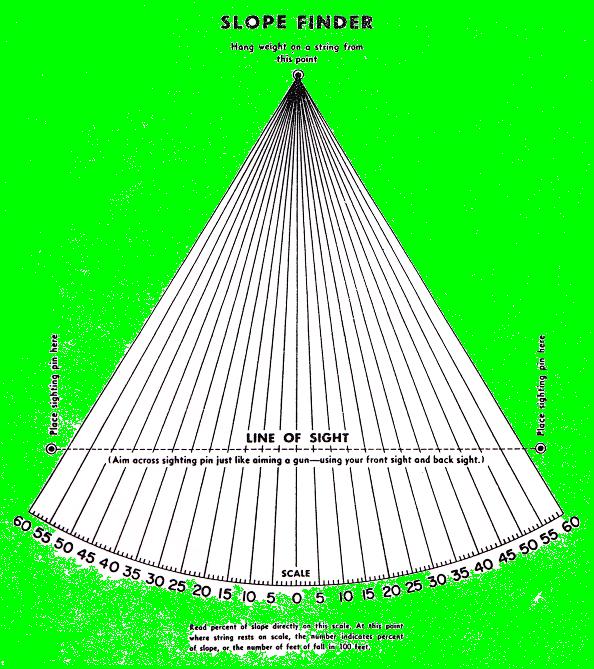
14 Slope The slope of the land is important for determining the best land use. The steepness and length of the slope influences the speed that water runs off and also the amount of soil erosion that could occur. On the Soil and Land Judging scoresheet, the steepness of slope is rated. Steepness of slope is expressed in percent, as in 14 percent slope. The percent slope can be translated as the number of feet of rise or fall over a 100 foot horizontal distance. For example, a 14 percent slope translates to a 14 foot rise or fall over a 100 foot distance. The steepness of slope is determined by using a slope finder, an Abney level, or a clinometer. The slope finder is typically used in the Vermont Soil and Land Judging Contest to determine the slope percentage. Directions on the construction and use of a slope finder are included below. In this event, slope stakes will be placed near the pit to be representative of the area around the test pit. Slope can be determined by measuring from the point marked on one stake to the point marked on the other stake with a slope finder. Note that measurements are not always made from the top of the stake, but from the point marked on the stake, which may be near the bottom of the stake sometimes. These markings are typically flagging tape wrapped around the slope stakes. The steepness of the slope affects the ease of cultivation and use of farm machinery, especially in terms of safety. The use of farm machinery is more difficult and hazardous on slopes over 15%. The steepness of the slope also affects non-farm uses such as housing, septic tank filter fields, roads, timber harvesting, and recreational uses. It is difficult and more expensive to develop home and commercial sites on steep slopes. Erosion is also a hazard in these areas. Logging is also more difficult on steep slopes. The slope classes on the scoresheet are as follows: 1. Nearly level - less than 3% slope 2. Gently sloping 3 to 8% slope 3. Sloping 9 to 15% slope 4. Moderately steep - 16 to 35% slope 5. Steep greater than 35% slope How to make a slope finder 1. Mount the prepared slope finder sheet (on the back cover of this guide) on a 9" X 12" board. Either 1/2-inch plywood or 3/4-inch lumber may be used. The thicker board is recommended in order for the nails to be securely attached. 2. Place three "finishing nails" at the points indicated on the slope finder. Attach a large nut or weight to a string tied to the top nail on the slope finder. Adjust the length of string to allow the weight to swing freely just below the edge of the board. How to use the slope finder The following procedures are recommended with two stakes and a slope finder: 1. The percent slope may be determined by either sighting up or down the slope. 2. It is not necessary to know the distance between the stakes. 12
15 3. Sighting through the two bottom nails, aim across from the marked point on one stake to the marked point on the other stake. 4. The string and weight should swing free. 5. On windy days, guard against wind error. 6. When the weight has stopped swinging, pinch the string against the board and read the percent slope. 7. It can help to tilt the board at a slight forward angle and when the weight stops swinging, to tilt it at a slight back angle to stabilize the string to read the slope. Surface Runoff Surface runoff is the rate at which water will move off a particular slope. This factor is important to engineers who design structures to convey or hold water. The ability of a watershed to absorb water is influenced by both surface runoff and subsurface drainage. There is a direct relationship between surface runoff and the steepness of the slope. You must first determine the slope class of the soil before deciding on the surface runoff class. The surface runoff classes and their slope ranges are: slow surface runoff - soils with slopes less than 3% moderate surface runoff - soils with slopes of 3 to 8% moderately rapid - soils with slopes of 9 to 15% rapid surface runoff - soils with slopes greater than 15% Soil texture and permeability also influence the amount of surface runoff relative to the amount of water that is absorbed by the soil. As water moves downslope, a certain amount of water will infiltrate into the soil, depending on texture and permeability. This is why less than half of a 2-inch rainfall may actually run off the land in some cases. The condition of the soil and its existing land use cover will also affect the amount of water that runs off. Saturated soils will absorb far less water than when they are dry, increasing the amount of surface runoff. A soil in a wooded area will have less runoff when compared to an identical soil that is bare and free of vegetation, partly because bare soils become crusted by raindrop impact, which increases the amount of surface runoff. 13
16 II. Evaluating Soil Physical Features to determine Land Use Potential Agricultural Potential - This information applies to parts B and C on the scoresheet. For rating Agricultural Potential, the soil will be placed into one of four categories: Prime Farmland, Good Potential, Low Potential, or No Agricultural Potential. Prime Farmland soils must have all of the following characteristics: depth to bedrock is more than 40 inches (deep) drainage class is well drained or moderately well drained slope is 8% or less (nearly level or gently sloping) topsoil texture is loamy or silty surface has none or few stones or rock outcrops Good Potential soils do not meet one or more of the Prime Farmland criteria, and have the following range of characteristics: slope is 15% or less depth to bedrock is 20 inches or greater (moderately deep or deep) drainage class is well drained or moderately well drained surface has none or few stones or rock outcrops all textures are allowed in this category Low Potential soils have one or more of the following characteristics, but do not qualify as a Soil with No Agricultural Potential: slope is greater than 15% depth to bedrock is less than 20 inches (shallow) drainage class is poorly drained surface is either very stony to extremely stony or very rocky to extremely rocky No Agricultural Potential is limited to soils that have the following combination of characteristics: slope is greater than 35% and surface is very rocky to extremely rocky Limitations to Woodland Potential This information applies to Part D on the scoresheet. Identification of limitations also requires application of management practices in Part F, Overcoming Site Limitations. In general, the majority of Vermont's soils have good Woodland Potential. But one should be aware of the factors that can limit woodland potential- 1. Soil wetness - soils that are poorly drained can result in harvesting problems with heavy equipment, seeding mortality (frost heaving), and windthrow hazards. 2. Depth to bedrock - soils that are less than 20 inches (shallow) to bedrock have a windthrow hazard, seedling mortality, and problems with limited moisture holding capacity. 3. Sites with a very rocky to extremely rocky surface can be difficult for establishing roads and trails, harvesting damage (felled trees can break on rock outcrops) and equipment limitations. 14
17 4. Slopes greater than 35% limit harvesting techniques, interfere with proper layout of wood roads and trails, and create severe erosion hazards during logging operations. In summary, sites that have limitations for tree growth and timber harvesting have one or more of the following conditions: poorly drained soils (redoximorphic features within 20 inches of the surface) shallow to bedrock soils soils with very rocky to extremely rocky surface slopes greater than 35% Site Suitability for Land Uses This information applies to Part E on the scoresheet. Identification of limitations also requires application of management practices in Part F, Overcoming Site Limitations. Determine if any soil feature or combination of features makes the site not suitable for each land use. Rate each feature as to whether it has unsuitable characteristics for that land use. 1. Housing (homes with on-site septic systems and basements) Any one of the following factors will make a site not suitable for housing: ~ areas that flood (parent material is alluvial deposits) ~ seasonal high water table within 20 inches (poorly drained soils) ~ bedrock within 20 inches (shallow to bedrock) ~ very rocky to extremely rocky surface ~ slope is greater than 35% (steep slopes) 2. Row crops (annual crops grown either continuously or in rotation with grasses and/or legumes) Any one of the following factors will make a site not suitable for row crops: ~ bedrock within 20 inches (shallow to bedrock) ~ very rocky to extremely rocky surface ~ slope is greater than 15% 3. Hayland (continuous grasses and/or legumes) The combination of both of the following two factors will make a site not suitable for hayland: ~ very rocky to extremely rocky surface, and ~ slope is greater than 35% (steep slopes) ~ if only one of the two factors is present, mark scoresheet # 34 False and consider the site suitable for hayland. 4. Woodland There are no factors that make a site not suitable for woodland in Vermont. 15
18 Land Use Site is not suitable because of: Flooding hazard (Alluvial deposits) House with Basement Row Crops Hayland & Septic 21. Alluvial deposit 26. Not limiting 31. Not limiting Soil Wetness (Drainage class) 22. Poorly drained 27. Not limiting 32. Not limiting Depth to Bedrock 23. < < Not limiting Very to Very to Extremely Rock Outcrops Extremely rocky rocky 34. Percent Slope 25. >35% 30. >15% Very to Extremely rocky - and - Slope >35% Overcoming Site Limitations. Determine the appropriate management practice that can be used to overcome limitations determined in previous Parts of the Worksheet. If you identified any feature or combination of features that made the site not suitable in Part E, mark F for all of the management practices for that land use. Mark T to select the appropriate management practices for each land use. Mark T for all that are appropriate. Mark F for all practices that are not appropriate for that site s features. Land Treatments and Management Practices to overcome Site Limitations 1. Subsoil Drainage - This practice involves the installation of "elephant trunk or perforated pipe to minimize wet areas in a field or around a house site by lowering the seasonal high water table. The soil must be greater than 40 inches to bedrock to allow installation of the pipe at least 3 feet into the ground. This practice would be beneficial on poorly drained agricultural soils. For housing on moderately well drained soils, subsoil drainage is recommended around the foundation and upslope of the septic tank filter field. 2. Diversions - A wide shallow surface ditch designed to intercept surface water moving downslope. This would be beneficial on agricultural and housing sites with slopes greater than 8% and with bedrock greater than 40 inches deep. It is not practical in woodland management. 3. Benching - This is a bench or terrace constructed on a slope, primarily for the installation of a septic system. This practice applies only to housing sites with slopes between 16-35% and with bedrock greater than 40 inches deep. 4. Land Clearing This is the removal of stones and boulders (and brush and trees if necessary) to establish housing, row crops, or hayland. This practice applies to sites with a very stony to extremely stony surface, regardless of whether they are wooded or not. 16
19 5. Omit basement in building plan - if bedrock is moderately deep (20-40 inches), it is often not practical to pour a basement under a house on that site. This practice should be applied on all housing sites with moderately deep bedrock between 20 and 40 inches. 6. Mound septic system needed - These septic systems are used on sites that are somewhat marginal for optimum performance. They are built on top of the existing soil to create a deeper treatment zone for effluent. They should be used on all housing sites that are moderately well drained or have moderately deep bedrock (20-40 inches). 7. Contour Farming This practice, used only for row crops, involves planting crops across the slope (on the contour) in order to minimize erosion. It also includes contour strip cropping, which alternates row crops and hay crops, planted on the contour. It is beneficial on sites used for row crops with slopes greater than 8%. 8. Irrigation for high-value crops - High value crops include truck crops like tomatoes, peppers, and other crops grown on small acreages and are typically seen for sale at farmer s markets. Irrigation should be used for these row crops if the topsoil texture or the subsoil texture is Sandy. 9. Maintain riparian buffers - For row crops and woodland sites, a vegetated riparian buffer along streams prevents streambank erosion and degraded water quality. These buffers should be maintained if the Parent Material is Alluvial Deposits on Floodplains. 10. Avoid deep-rooted legumes - Legumes like alfalfa have a deep taproot that can extend six feet or more into the soil under ideal conditions. When soils remain very wet over winter, excessive frost action from freezing and thawing can drive this taproot right up out of the soil and kill these valuable hay and pasture plants. If the Natural Soil Drainage class is poorly drained, these deep-rooted legumes should be avoided in seeding mixes for that site. 11. Specialized Harvesting Equipment - The use of specialized timber harvesting equipment, such as cables and tracked vehicles, should be used on woodland sites with slopes greater than 35%. 12. Erosion Control - The installation of water bars and ditches to minimize erosion on logging roads and trails. It also involves siting skid trails and log landings based on a site plan designed to minimize soil erosion. This practice should be applied to all woodland sites with slopes greater than 8%. 13. Seasonal Harvesting - Limits logging operations to drier periods of the year or when the ground is frozen to minimize rutting of wet soils. This practice should be applied in all woodland sites with poorly drained soils. III. Using the Scantron scorecard on the day of the Event One Scantron scorecard will be filled out for each of the four sites and turned in to the proctor at the site. Be sure you have 4 blank scorecards when you start out at the beginning of the event. The scorecard is divided into six parts. Part A provides basic data by evaluating the physical features of the soil. In Part A, mark the one letter that best identifies the correct physical characteristic. 17
20 Parts B and C consider the physical features of the soil in relation to its agricultural potential. In Part B, mark the one letter that best identifies the agricultural potential. In Part C, mark correct answers True and mark all incorrect answers False. Part D consider the physical features of the soil in relation to its woodland potential. Mark correct answers True and mark all incorrect answers False. Part E identifies the site suitability for the following land uses: construction of a home, with basement and septic system, and production agriculture, including row crops and hay. Mark correct answers True and mark all incorrect answers False. Part F identifies management practices needed to overcome site limitations. Mark correct answers True and mark all incorrect answers False. 18
21 Vermont Soil and Land Judging Contest Scoresheet for Evaluating Soil and Land revised Oct. 5, 2012 Part A. Physical Features of the Soil and Site. Mark only one answer for each question. 1. Texture of Topsoil 7. Soil Permeability A Sandy A Rapid B Loamy and Silty B Moderate C Clayey C Slow 2. Texture of Subsoil 8. Surface Stones and Rock Outcrops A Sandy A None or Few B Loamy and Silty B Very Stony to Extremely Stony C Clayey C Very Rocky to Extremely Rocky 3. Parent Material 9. Slope Class A Glacial Till A Nearly Level B Glacial Outwash B Gently Sloping C Alluvial Deposits on Floodplain C Sloping D Lacustrine Deposits D Moderately Steep E Steep 4. Natural Soil Drainage Class A Well Drained 10. Surface Runoff B Moderately Well Drained A Slow C Poorly Drained B Moderate C Moderately Rapid 5. Depth to Bedrock D Rapid A Deep B Moderately Deep 11. Part B. Agricultural Potential. Select one: C Shallow A Prime Farmland 6. Root Limiting Layer B Good Potential A Depth to Bedrock C Low Potential B Seasonal High Water Table D No Agricultural Potential C Strongly Contrasting Textural Change D None Part C. Factors that keep the site out of 12. Texture of Topsoil T F 15. Stones/Rock Outcrops T F Prime Farmland. Answer all questions. 13. Drainage Class T F 16. Slope Class T F Mark T (for Yes) to select those factors that 14. Depth to Bedrock T F keep site out of Prime. Mark all other answers F (for No). 19
22 Part D. Limitations to Woodland Potential Judge all sites for their limitations to woodland potential, even if they are not wooded. Check as many answers T as are correct. Mark all other answers F. Limitations to woodland potential at this site are: 17. T F Soil wetness 18. T F Depth to bedrock 19. T F Rock outcrops 20. T F Steep slopes Part E. Site Suitability for Land Uses. Based on Part A, determine if any soil features makes the site not suitable for each land use. Rate each feature as to whether it has unsuitable characteristics for that land use. Note that there are no soil features that make a site not suitable for Woodland in Vermont. Mark T for any feature or combination of features that makes the site unsuitable for housing, row crops or hayland. If any feature or combination of features is marked T, the site is not suitable for that land use. Mark F if the soil feature does not have unsuitable characteristics for that land use. Land Use Site is not suitable because of: House with Basement & Septic Row Crops Hayland Flooding hazard (Alluvial deposits) 21. T F 26. T F 31. T F Soil Wetness (Drainage class) 22. T F 27. T F 32. T F Depth to Bedrock 23. T F 28. T F 33. T F Rock Outcrops 24. T F 29. T F Slope Class 25. T F 30. T F 34. T F Part F. Overcoming Site Limitations. Determine the appropriate management practices that can be used to overcome site limitations determined in previous Parts of the Worksheet. If you identified any features that made the site not suitable in Part E, mark F for all of the management practices for that Land Use. Mark T to select the appropriate management practices for each Land Use. Mark T for all that are appropriate. Mark F for all practices that are not appropriate for that site s features. Housing (with basement and septic system) 35. T F Subsoil drainage Hayland 36. T F Diversions 47. T F Subsoil drainage 37. T F Benching 48. T F Diversions 38. T F Land clearing 49. T F Land clearing 39. T F Omit basement in build plan 50. T F Avoid deep-rooted legumes 40. T F Mound septic system needed Woodland Row Crops 51. T F Specialized harvesting equipment 41. T F Subsoil drainage 52. T F Erosion control 42. T F Diversions 53. T F Seasonal harvesting 43. T F Land clearing 54. T F Maintain riparian buffers 44. T F Contour farming 45. T F Irrigation for high-value crops 46. T F Maintain riparian buffers 20
23 21
2014 Iowa FFA Soil Judging CDE Exam
 2014 Iowa FFA Soil Judging CDE Exam 1. Landscape position is one aspect of evaluating the surface features of a certain tract of land. Identifying the correct landscape position will indicate: a. If the
2018 Iowa FFA Soil Judging CDE Exam 1. Landscape positions characterizes the location of the soil on the landscape and identifies potential risks.
 2018 Iowa FFA Soil Judging CDE Exam 1. Landscape positions characterizes the location of the soil on the landscape and identifies potential risks. Which landscape position is considered the floodplain
Pits 1 & 3 Questions. 7. Subsurface: Texture (5 pts) A. Coarse B. Moderately course C. Medium D. Fine E. Very Fine
 A. Coarse B. Moderately course C. Medium D. Fine E. Very Fine") Minnesota Soils Scorecard Questions for Pits 1-4 Scantron # 105481 Use your soils scorecard to fill out the answers on your scantron Bubble in the front side of the sheet for Pit 1 (# 1-45) and Pit 2 (#51-95)
Minnesota Soils Scorecard Questions for Pits 1-4 Scantron # 105481 Use your soils scorecard to fill out the answers on your scantron Bubble in the front side of the sheet for Pit 1 (# 1-45) and Pit 2 (#51-95)
Iowa FFA Soil Career Development Event 2008
 Iowa FFA Soil Career Development Event 2008 1. In Iowa, corn suitability ratings for soil mapping units specifies a. natural weather conditions b. surface and subsurface drainage installed where needed
2017 Iowa FFA Soil Judging CDE Exam
 2017 Iowa FFA Soil Judging CDE Exam 1. Landscape positions vary in soil composition and makeup. What landscape position would be characterized by having strata and lenses of different textures in the profile:
IOWA FFA STATE SOILS CDE SATURDAY, OCTOBER 13, 2007 AMES, IOWA
 IOWA FFA STATE SOILS CDE SATURDAY, OCTOBER 13, 2007 AMES, IOWA 1. Moderately sloping has what percent slope: a. 9-14% b. 2-5% c. 5-9% d. over 14% 2. Which of the following horizons is the loose underlying
List of Equipment, Tools, Supplies, and Facilities:
 Unit A: Principles of Soil Lesson 4: Formation of Soil Student Learning Objectives: Instruction in this lesson should result in the students achieving the following objectives: 1. Identify 5 factors involved
1. Position (2 pts.) 2. Parent Material (2 pts.) 3. Slope Characteristics (2 pts.) 4. Surface Stoniness or Rockiness (2 pts.)
 2. Parent Material (2 pts.) 3. Slope Characteristics (2 pts.) 4. Surface Stoniness or Rockiness (2 pts.)") Maryland Envirothon SOILS Exam Guidance Information (revised 2017) Objective: To test students' knowledge and awareness of basic soil science and its application in wise land-use planning and therefore
Maryland Envirothon SOILS Exam Guidance Information (revised 2017) Objective: To test students' knowledge and awareness of basic soil science and its application in wise land-use planning and therefore
2011 Wisconsin Envirothon Soils and Land Use Exam
 2011 Wisconsin Envirothon Soils and Land Use Exam USE THE OCONTO COUNTY SOIL SURVEY TO ANSWER QUESTIONS 1-4 The Pensaukee River Wetland Complex is a mixture of state (Pensaukee Wildlife Area) and privately
Land Capability Classifications
 Land Capability Classifications Unit: Soil Science Problem Area: Basic Principles of Soil Science Student Learning Objectives. Instruction in this lesson should result in students achieving the following
2016 Iowa FFA Soils Evaluation CDE Exam
 2016 Iowa FFA Soils Evaluation CDE Exam 1. Which of the following is true regarding soil horizons? a. A horizon is darker in color and has more organic matter b. B horizon is darker in color and has more
Horner-McLaughlin Woods: Soil Types
 Horner-McLaughlin Woods: Soil Types Not present at HMW Adrian Muck Conover Loam 0-4% Slopes Houghton Muck Miami Loam 2-6% Slopes Miami Loam 6-12% Slopes Miami Loam 12-18% Slopes t 0 0.125 0.25 Miles Mary
Section 1. Judging the soil pit (questions 1-4)
") CONNECTICUT ENVIROTHON 2009 SOILS QUESTIONS Please select the best response to the following questions. There are 25 questions; each question is worth 4 points. Section 1. Judging the soil pit (questions
CONNECTICUT ENVIROTHON 2009 SOILS QUESTIONS Please select the best response to the following questions. There are 25 questions; each question is worth 4 points. Section 1. Judging the soil pit (questions
HORT 102: Soil Properties. Cultivated Plants: Lecture 15. [Teresa Koenig] Slide #: 1 Slide Title: Intro Information Slide
![HORT 102: Soil Properties. Cultivated Plants: Lecture 15. [Teresa Koenig] Slide #: 1 Slide Title: Intro Information Slide](/thumbs/76/74082590.jpg "HORT 102: Soil Properties. Cultivated Plants: Lecture 15. [Teresa Koenig] Slide #: 1 Slide Title: Intro Information Slide") HORT 102: Soil Properties Cultivated Plants: Lecture 15 [Teresa Koenig] Slide #: 1 Slide Title: Intro Information Slide Title: Lecture 15 Soil Properties Speaker: Teresa Koenig Created by: Teresa Koenig,
HORT 102: Soil Properties Cultivated Plants: Lecture 15 [Teresa Koenig] Slide #: 1 Slide Title: Intro Information Slide Title: Lecture 15 Soil Properties Speaker: Teresa Koenig Created by: Teresa Koenig,
Alluvium Bedrock Chemical Weathering Climate Glacial Till Loess Native Vegetation
 1 Alluvium Bedrock Chemical Weathering Climate Glacial Till Loess Native Vegetation Organic Matter Outwash Parent Material Physical Weathering Prairie Soils Timber Soils Topography 2 There are five primary
2016 Area 3 Envirothon Muskingum County Soils Test ANSWER KEY
 2016 Area 3 Envirothon Muskingum County Soils Test ANSWER KEY 1. The majority of the bedrock in Muskingum County is. a. sedimentary bedrock b. glacial bedrock c. igneous bedrock d. metamorphic bedrock
2012 FINAL SOILS AREA 2 Envirothon Questions Answer KEY
 2012 FINAL SOILS AREA 2 Envirothon Questions Answer KEY Questions 1-6 to be answered at the soil pit: 1. Soil scientists categorize soils by drainage classes. What is the drainage class of the soil at
Soil Horizons cont. Oa- highly decomposed Oi-undecomposed
 Soils Soil Basics Soil Horizons Soil Horizons cont. O Horizon: Or organic layer Organic layer of decomposing plant and animal tissue. Wooded upland areas have thin O horizons Wetlands may have thick O
There are different types of weathering weathering and weathering. Both types work together to change Earth s surface.
 Weathering effects Classifying Sediment The surface processes that break down rock are called. Weathering breaks rock into smaller and smaller pieces. Tiny moss plants, earthworms, wind, rain, and even
The Nature of Soil Soil Conservation Sustainable Ag.
 Chapter 6 & 7 The Nature of Soil Soil Conservation Sustainable Ag. Climate Soil Forming Factors Parent material Organisms Topography Time Value of Soil Soil is under appreciated Condition of soil affects
A GUIDE FOR LAND JUDGING IN MICHIGAN. D. L. Mokma, E. Dersch and D. Kesselring
 A GUIDE FOR LAND JUDGING IN MICHIGAN D. L. Mokma, E. Dersch and D. Kesselring Michigan State University in cooperation with the Michigan Chapter of the Soil and Water Conservation Society The study of
Soils and the Environment. A Summary of RI Envirothon Study Materials Compiled by Sally Paul
 Soils and the Environment A Summary of RI Envirothon Study Materials Compiled by Sally Paul Why Soils Food and water resources Disposing of waste Support for human structures Growing timber and fibers
This definition is from the Soil Science Glossary (Soil Science Society of America).
.") What is Soil? This definition is from the Soil Science Glossary (Soil Science Society of America). soil - (i) The unconsolidated mineral or organic material on the immediate surface of the earth that serves
What is Soil? This definition is from the Soil Science Glossary (Soil Science Society of America). soil - (i) The unconsolidated mineral or organic material on the immediate surface of the earth that serves
WEATHERING AND SOIL FORMATION. 8th Grade- Mr. Stelma
 WEATHERING AND SOIL FORMATION 8th Grade- Mr. Stelma WEATHERING EFFECTS The surface processes that break down rock are called weathering. Weathering breaks rock into smaller and smaller pieces. Tiny moss
Team number Page 1 of Canon Envirothon Soils Station Test. Soils and Climate Change
 Team number Page 1 of 9 2006 Canon Envirothon Soils Station Test Soils and Climate Change There are many kinds of soil on the surface of the earth. The kind of soil that is present at a given location
Lesson 3: Understanding Soil Color
 Lesson 3: Understanding Soil Color 1 Bright colored Color Dull colored Humus Mottle colored Native vegetation Structure Tall prairie grass Texture Deciduous hardwood forest 2 I. Soils have many features
CONNECTICUT ENVIROTHON 2012 SOILS QUESTIONS
 CONNECTICUT ENVIROTHON 2012 SOILS QUESTIONS Please select the best response to the following questions. There are 25 4 point questions. Many have more than one part. Good luck! Section 1: Judging the soil
Unit E: Basic Principles of Soil Science. Lesson 3: Understanding Soil Color
 Unit E: Basic Principles of Soil Science Lesson 3: Understanding Soil Color 1 Important Terms Bright-colored Color Deciduous hardwood forest Dull-colored Humus Mottle-colored Native vegetation Structure
List of Equipment, Tools, Supplies, and Facilities:
 Unit C: Traits of Soil Lesson 3: Understanding Soil Color Student Learning Objectives: Instruction in this lesson should result in the students achieving the following objectives: 1. Identify physical
Soil Geography Notes JC-Learn. JC-Learn. Geography Notes Soil. 1 P a g e
 JC-Learn Geography Notes Soil 1 P a g e Soil Soil is the thin covering of loose material that makes up the outermost layer of our planet. It is a living thing and a rich natural resource. Plants need soil
EDULABZ. Ans. (b) 7. The soft, porous layer with a good water-retaining capacity forms the
 7. The soft, porous layer with a good water-retaining capacity forms the") 3 SOIL I. Multiple choice questions: Tick ( ) the correct choice. 1. The process of soil formation is called (a) conservation (b) weathering (c) erosion (d) none Ans. (b) 2. Soil profile consists of (a)
3 SOIL I. Multiple choice questions: Tick ( ) the correct choice. 1. The process of soil formation is called (a) conservation (b) weathering (c) erosion (d) none Ans. (b) 2. Soil profile consists of (a)
Soil Interpretations Erosion and Sedimentation Control Planning and Design Workshop
 Soil Interpretations Erosion and Sedimentation Control Planning and Design Workshop Presented by Richard Brooks Presentation prepared by Kristin May Resource Soil Scientists USDA-Natural Resources Conservation
DO YOU KNOW YOUR SOILS? (Rev. 10/11)
") DO YOU KNOW YOUR SOILS? (Rev. 10/11) Circle all the correct answers. 1. What is the layer normally present on the surface of the soil in cropped fields? a. O c. Ap e. B g. R b. A d. E f. C 2. Available
DO YOU KNOW YOUR SOILS? (Rev. 10/11) Circle all the correct answers. 1. What is the layer normally present on the surface of the soil in cropped fields? a. O c. Ap e. B g. R b. A d. E f. C 2. Available
Tunbridge. Vermont State Soil. Soil Science Society of America. Introduction. History. What is the Tunbridge Soil?
 Tunbridge Vermont State Soil Soil Science Society of America Introduction Many states have a designated State bird, flower, fish, tree, or rock. And many states also have a State soil one that has significance
STATE TAX COMMISSION OF MISSOURI ASSESSOR MANUAL
 STATE TAX COMMISSION OF MISSOURI ASSESSOR MANUAL CHAPTER: REVISION DATE: 10/1/2008 Page 1 of 18 7.3 The purpose of this section of the Assessor s Manual is to supplement the State Tax Commission s published
2014 Envirothon Georgia Soil Study Guide
 2014 Envirothon Georgia Soil Study Guide In addition to materials in this document, 2014 Georgia Envirothon contestants are responsible for materials found in the following documents: From The Surface
ENVIROTHON SOILS GUIDE. based on a team problem-solving concept. For this reason, some questions may require
 1 ENVIROTHON SOILS GUIDE This guide contains the information that teachers and students need to compete in the soils portion of the Tennessee Envirothon. Answers to contest questions will come directly
1 Describe the concept of soil texture and its importance. 2 Determine the texture of a soil sample.
 Interest Approach Provide students with various samples of soil. One sample should be nearly all sand, one nearly all clay, and one nearly all silt. Ask students to determine how the samples differ. Would
Loam: About 40% sand, 40% silt, 20% clay. Mixture of pore sizes to balance water retention and aeration. Considered the best soil for growing crops.
 Soil Characteristics Soil is formed from a combination of two Primary sources: Weathering of Parent Rock ( ) = material introduced by plants, animals, and decomposers Minor sources: Nutrients incorporated
Examining soils in the field. Examining soils in the field. Environment Agency thinksoils examining soils in the field
 Examining soils in the field thinksoils Examining soils in the field Environment Agency thinksoils examining soils in the field 31 Examining soils in the field 32 Environment Agency thinksoils examining
DIRT! APES Laboratory Activity
 Name: Part I: Soil Texture DIRT! APES Laboratory Activity Can one determine the texture of soil by examining the particles found in a particular sample? The purpose of this activity is to determine the
Recommended Resources: The following resources may be useful in teaching
 Unit B: Establishing a Fruit Garden Lesson 1: Recognize the Characteristics of Soils and the Soil Requirements for Fruit and Nut Crops Student Learning Objectives: Instruction in this lesson should result
Soil Colors, Texture & Structure
 Application Soil Colors, Texture & Structure Limiting conditions Soil color type/depth of system Bedrock type/depth of system Soil texture, structure, percolation rate size and type of system Sara Heger,
PHYSICAL CHAtlACTERISTICS REPORT FOR THE PROPOSED SAND AND GRAVEL SITE AT MANOR FARM, UFFINGTON
 PHYSICAL CHAtlACTERISTICS REPORT FOR THE PROPOSED SAND AND GRAVEL SITE AT MANOR FARM, UFFINGTON Introduction Following the" request for detailed information on the physical characteristics of soil at Manor
1. The Nature of Soils and Soil Fertility
 1. The Nature of Soils and Soil Fertility The Ontario Soil Fertility Handbook contains information on the fundamental concepts of soil fertility. If you have ever wondered how nutrients make their way
EXAMPLE Point A: Sandy Loam: 65% Sand _ 20% Silt _ 15% Clay. Point B: %Sand % Silt % Clay. Point C: %Sand % Silt % Clay. Point D: %Sand % Silt % Clay
 SOIL TEXTURE Refers to proportions of sand, silt and clay size particles. These proportions determine water infiltration rates, permeability rates, and water holding rates. Using a soil texture triangle.
Understanding Soils. 1. What is Soil? 2. What does soil do for us?
 Understanding Soils 1. What is Soil? Soil: (i) The unconsolidated mineral or organic material on the immediate surface of the earth that serves as a natural medium for the growth of land plants. (ii) The
Land Judging in West Virginia
 Guide 406R-LJ Revised 2017 Land Judging in West Virginia A program of WVU Extension Service 4-H and Agriculture and Natural Resources extension.wvu.edu/youth-family/youth-evaluation/landjudging Land Judging
Using Land Capability Classifications
 Lesson C7 2 Using Land Capability Classifications Unit C. Plant and Soil Science Problem Area 7. Soil Erosion and Land Management Lesson 2. Using Land Capability Classifications New Mexico Content Standard:
Lesson 1: Recognizing the Characteristics of Soils and the Soil Requirements for Fruit and Nut Crops
 Lesson 1: Recognizing the Characteristics of Soils and the Soil Requirements for Fruit and Nut Crops 1 Mineral matter Organic matter Pore spaces Tilth Hygroscopic water Soil aeration 22 I. Soil is a layer
THE TENNESSEE VEGETABLE GARDEN
 THE BACKYARD SERIES BACKYARD VEGETABLES W 346-A THE TENNESSEE VEGETABLE GARDEN SITE SELECTION AND SOIL TESTING Natalie Bumgarner, Assistant Professor and UT Extension Residential and Consumer Horticulture
4-H Land Judging in Kentucky
 COOPERATIVE EXTENSION SERVICE UNIVERSITY OF KENTUCKY COLLEGE OF AGRICULTURE, LEXINGTON, KY, 40546 4BA-08MG 4-H Land Judging in Kentucky David Ditsch, Lloyd Murdock, Bill Thom, Monroe Rasnake, and Greg
3. What are the five master horizons? Give distinguishing features of each. 5. List three means by which plant roots come into contact with nutrients.
 Study Questions Exam 1 1. What are the four general components of soil? 2. Define regolith and solum. 3. What are the five master horizons? Give distinguishing features of each. 4. What is meant by an
FFA Urban Soil CDE. Items necessary for soil judging. FFA Land Judging Contest 2015
 FFA Urban Soil CDE FFA Land Judging Contest 2015 Changes are coming to the Soil Judging Career Development Event (CDE), starting in the upcoming school year, to better reflect today s challenges with soil.
Soil characteristics that influence nitrogen and water management
 Section C Soil characteristics that influence nitrogen and water management Soil characteristics vary across the landscape Soils vary from one field to another, and often within the same field. Soil differences
Introduction to Environmental Science. Soil Characteristics. Chapter 11 Soil
 Chapter 11 Soil Soil Characteristics It s more than dirt Most soils are 100s of years old Weathering breaks down parent rock Soil Separates (particle types) Sand (largest) Silt Clay (smallest) Plants contribute
Unit II Soil Management
 Unit II Soil Management Lesson 2: Using Soil Survey Manuals Soil survey manuals provide useful information for grassland management. Soil scientists evaluate the soil for chemical and physical properties,
AY-362-W. INDIANA SOIL Evaluation Field Book. Don Franzmeier, Gary Steinhardt, Cathy Egler Purdue University Department of Agronomy
 AY-362-W INDIANA SOIL Evaluation Field Book Don Franzmeier, Gary Steinhardt, Cathy Egler Purdue University Department of Agronomy Table of Contents PREFACE 3 CHAPTER 1 Soil Formation, Soil Properties,
Soil Notes. General Soil Information
 Soil Notes General Soil Information Definition Soil relatively thin surface layer of the Earth s crust consisting of mineral and organic matter that is affected by agents such as weather, wind, water,
Soils and Land Use Test
 SOIL PROPERTIES Total Score /50 1) List two of the five main functions of soil. (2 points) Habitat for organisms, Engineering medium, Filters and stores water, Anchor for plants, Cycles nutrients 2) Small
Topoclimate Southland Soil Technical Data Sheet No Waiau
 This Technical Data Sheet describes the typical average properties of the specified soil. It is essentially a summary of information obtained from one or more profiles of this soil that were examined and
Unit 1 Lesson 5 Soil Formation. Copyright Houghton Mifflin Harcourt Publishing Company
 The Dirt on Soil What causes soil to form? Soil is a loose mixture of rock fragments, organic matter, water, and air that can support the growth of vegetation. The first step in soil formation is the weathering
CfE Higher Geography BIOSPHERE
 CfE Higher Geography BIOSPHERE WHAT ARE THE OUTCOMES? 1. Use a range of mapping skills and techniques in physical environment contexts by: 1.1 Interpreting complex geographical information from at least
Girtridge Monitor Farm Meeting
 Girtridge Monitor Farm Meeting 15 th August 2018 1 Managing Soil Drainage and Compaction in Pasture Key factors for movement of water in the soil Soil Texture Soil Structure Soil Compaction 2 1 Soil Texture
Soil testing Page 1. Contrary to what is widely believed, the colour of the soil reveals very little about its fertility.
 Soil testing Page 1 Soil The Basics Soil is the uppermost surface of the earth, which has been slowly transformed by decomposition due to the effects of weather, vegetation and human activities. The parent
Area 3 Envirothon Soils Questions Key
 Area 3 Envirothon Soils Questions Key 1. Soil aeration is the exchange of air in soil with air from the atmosphere. When a soil is well aerated, the air within the soil is very similar to the atmosphere
Soil Chemistry. Key Terms.
 Soil Chemistry Key Terms Key Terms in Soil Chemistry Buffering capacity - this is the soil's ability to resist changes in soil ph. Soils with a high buffering capacity require a great deal of amendment
California FFA Soil and Land Evaluation Manual
 California FFA Soil and Land Evaluation Manual Sixth Edition Kelly S. Carter Brent G. Hallock Terence H. Cooper Logan S. Carter Copyright 1980, 1986, 1989, 1997, 2017 California Polytechnic State University
Land Judging and Homesite Evaluation Guidebook
 Land Judging and Homesite Evaluation Guidebook Kansas State University Agricultural Experiment Station and Cooperative Extension Service INTRODUCTION The study of land and its wise use should be important
FFA Rural Soil CDE. Items necessary for soil judging. FFA Land Judging Contest 2015
 FFA Rural Soil CDE FFA Land Judging Contest 2015 Changes are coming to the Soil Judging Career Development Event (CDE), starting in the upcoming school year, to better reflect today s challenges with soil.
4H HPS 101 Land Judging In Oklahoma
 4H HPS 101 Land Judging In Oklahoma Extension 4-H MEMBER S GUIDE Oklahoma Cooperative Extension Service Division of Agricultural Sciences and Natural Resources Oklahoma State University 1 Table of Contents
Sam Houston Ranger District West/Central WUI Fuels Reduction Project Soil and Water Resources
 Soil and Water Resources The Sam Houston National Forest has identified specific wildland urban interface (WUI) areas within Compartments 33, 36, 37, 49, 57, and 66 that contain high fuel loadings. This
Soil Resources. Soil Horizons
 Soil Resources Soil Uppermost layer of earth s crust that supports plants, animals and microbes Soil Forming Factors Parent Material Time Climate Organisms Topography Soil Composition Mineral Particles
LAND JUDGING AND SOIL EVALUATION
 LAND JUDGING AND SOIL EVALUATION June 1998 W. J. Edmonds, P. J. Thomas, T. W. Simpson, and J. C. Baker Virginia Polytechnic Institute and State University Department of Crop and Soil Environmental Sciences
Secondary Consumer (Carnivore or Omnivore)
") Chapter 8 - Water and Soil Conservation Benefits of Living Organisms for Water and Soil 1. plants break fall of rain and reduce damage to the soil 2. plant materials on the soil provide a rain absorbing
Chapter 8 - Water and Soil Conservation Benefits of Living Organisms for Water and Soil 1. plants break fall of rain and reduce damage to the soil 2. plant materials on the soil provide a rain absorbing
5.1 Introduction to Soil Systems IB ESS Mrs. Page
 5.1 Introduction to Soil Systems IB ESS Mrs. Page 2015-2016 I Am Soil Thinking Routine: See, Think, Wonder Look at the following images. For each image write down what you see Then write down what you
a. OVERALL PROFILE DEPTH: Assess the depth to the first restrictive layer, which can be a tree root, a rock or an
 OBSERVING SOIL PROCEDURE Using a shovel, soil probe, or soil auger, collect a soil profile. (Go as deep as you can with the equipment). Arrange the soil you remove from the ground on newspaper or in a
Soil is. Pieces of rock Minerals Decaying organic matter Water Air Living organisms All mixed together!
 Soil is. Pieces of rock Minerals Decaying organic matter Water Air Living organisms All mixed together! Soil Horizons the layers of soil O-horizon: the surface litter. Mainly black or brown A-horizon:
EARTH SCIENCE CONCEPTS -Geologic time scale
 EARTH SCIENCE CONCEPTS -Geologic time scale -Plate Tectonics -Earthquakes *result of vibrations (often due to plate movement) deep in the Earth that release energy *often occur at transform boundaries
List of Equipment, Tools, Supplies, and Facilities:
 Unit A: Principles of Soil Lesson 3: Horizons of Soil Student Learning Objectives: Instruction in this lesson should result in the students achieving the following objectives: 1. Explain a soil profile
4/23/2018. Soil John Wiley & Sons, Inc. All rights reserved. Lecture 14
 Lecture 14 Soil Lecture 14 1. The Soil System 2. Soil Properties and Major Soil Types 3. Environmental Problems Related to Soil 4. Soil Conservation and Regeneration 1 The Soil System Soil Uppermost layer
Eco new farmers. Module 2 Soil and Nutrient Cycling. Section 1 Soils and soil fertility
 Eco new farmers Module 2 Soil and Nutrient Cycling Section 1 Soils and soil fertility Module 2 Soil and Nutrient Cycling Section 1 - Soils and soil fertility www.econewfarmers.eu 1. Introduction You will
Soil Physical Properties
 Soil Physical Properties ESRM 311 SEFS 507 Some examples of mineral soil development eg, Rock Weathering Types of Weathering Physical/Mechanical Chemical Biological Photo by D Vogt CO 2 + H 2 O H 2 CO
Recommended Resources: The following resources may be useful in teaching this lesson:
 Unit E: Basic Principles of Soil Science Lesson 4: Understanding Soil Texture and Structure Student Learning Objectives: Instruction in this lesson should result in students achieving the following objectives:
A Guide for High School Land Judging Contests
 NATURAL RESOURCES ASSESSMENTS Soil Evaluations in Washington State A Guide for High School Land Judging Contests August 2014 PURPOSES OF LAND JUDGING CONTEST Land judging serves as a tool to teach youth
STATEMENT OF PHYSICAL CHARACTERISTICS AND AGRICULTURAL LAND CLASSIFICATION WITTON PARK, COUNTY DURHAM PROPOSED QUARRY EXTENSION DECEMBER 1992

LAB 12: Soils. Name School. Patrich Physical Geography Lab 1
 Name School LAB 12: Soils Soil is a mixture of weathered rock & organic matter that usually covers bedrock (solid rock that underlies all soil). Both chemical & mechanical processes are involved in the
B. Land capability subclass - DELETED Determine Land Capability Subclass according to the following rules. Mark all subclasses that apply.
 1 Indiana Soils: Evaluation and Conservation (ID-72, 7/01; rev8/08) Summary of rule changes D. P. Franzmeier and G. C. Steinhardt The changes in rules and the reasons for making them are summarized here.
Soil Characteristics. Soil Science 101
 Craig R. Miller Parks & Open Space Manager www.cpnmd.org Soil Characteristics There are several ways to describe soil. Understanding the characteristics of soil helps the gardener amend soil. Urban soil
Lornshill Academy. Geography Department Higher Revision Physical Environments - Biosphere
 Lornshill Academy Geography Department Higher Revision Physical Environments - Biosphere Physical Environments Biosphere Properties and formation processes of podzol, brown earths and gley soils Natural
Unit 5: Soil - Stages of Soil formation
 Biology Form 3 Page 68 Ms. R. Buttigieg Unit 5: Soil - Stages of Soil formation Soil is the layer of material covering parts of the land, the home of many organisms and the area from which land plants
Soil Formation. 6.E.2.3 Explain how the formation of soil is related to the parent rock type and the environment in which it develops.
 Soil Formation 6.E.2.3 Explain how the formation of soil is related to the parent rock type and the environment in which it develops. What is soil? A loose mixture of weathered rock, organic material,
3 From Bedrock to Soil
 CHAPTER 10 3 From Bedrock to Soil SECTION Weathering and Soil Formation BEFORE YOU READ After you read this section, you should be able to answer these questions: What is soil? How do the features of soil
The relationship between soil (growing
 4 Plant, Soil and Water Relationships The relationship between soil (growing media), air, and water is one of the least understood aspects in production and maintenance of plants. As a result, a significant
ASTOUNDING as it may seem, a shovelful of soil
 The Nature of Soil ASTOUNDING as it may seem, a shovelful of soil holds more living things than all the humans that have ever been born. Living things are just one component of soil, a material undervalued
Key factors for movement of water in the flood plain
 This event is being run by SAC Consulting Managing Soil and Drainage in the Flood Plain Key factors for movement of water in the flood plain Soil Texture Soil Structure Natural drainage paths Artificial
Reference Card S-2, Side A: Delineating Horizon Boundaries
 Reference Card S-2, Side A: Delineating Horizon Boundaries Distinguishing Soil Horizons Soil horizons are delineated based on differences in: Texture Color Structure and Consistence Redoximorphic Features
3 PHYSICAL PROPERTIES
 3 PHYSICAL PROPERTIES 3.1 Introduction Physical properties are those which deal with aspects of the material that are related to the bulk properties of the material. In other words, if chemical properties
Soil Organic Matter. Organic Carbon and Nitrogen. What Factors Influence the Amount of SOM? What is Soil Organic Matter? Why is SOM Important?
 Soil Organic Matter Organic Carbon and Nitrogen Analysis of soil organic matter (SOM), conducted on the AESA Soil Quality Benchmark sites, has revealed some significant differences in the per cent of organic
URBAN SOILS & SEATTLE EXAMPLES
 Class Results - Mystery Soil #1 14 12 10 8 6 4 2 0 Sandy Clay Loam Sandy Loam Silty Loam Class Results - Mystery Soil #2 6 5 4 3 2 1 0 Silty Clay Clay Loam Sandy Sandy Silty Sandy Silty Loamy Loam Clay