Downton Manor, Downton, near Lymington, Hampshire
|
|
|
- Erik Nichols
- 5 years ago
- Views:
Transcription
1 Downton Manor, Downton, near Lymington, Hampshire An Archaeological Evaluation for New Milton Sand and Gravel by Sian Anthony Thames Valley Archaeological Services Ltd Site Code DMD03/20 May 2003
2 Summary Site name: Downton Manor Farm, Downton, near Lymington, Hampshire Grid reference: SZ Site activity: Evaluation Date and Duration of Project: 28th April to 8th May 2003 Area of Site: c. 7.2hectares Project manager: Steve Ford Site supervisor: Sian Anthony Site code: DMD03/20 Summary of results: One ditch and one gully, six postholes and two potential postholes were located, all undated, with one unstratified find of Bronze Age pottery. Monuments identified: None Location and reference of archive: The archive is presently held by Thames Valley Archaeological Services, De Beauvoir Road, Reading, RG1 5NR and will be deposited with Hampshire Museum Service in due course. This report may be copied for bona fide research or planning purposes without the explicit permission of the copyright holder Report edited/checked by: Steve Ford Steve Preston i
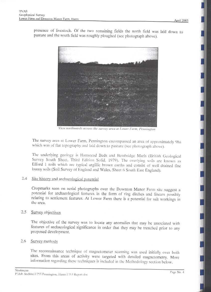
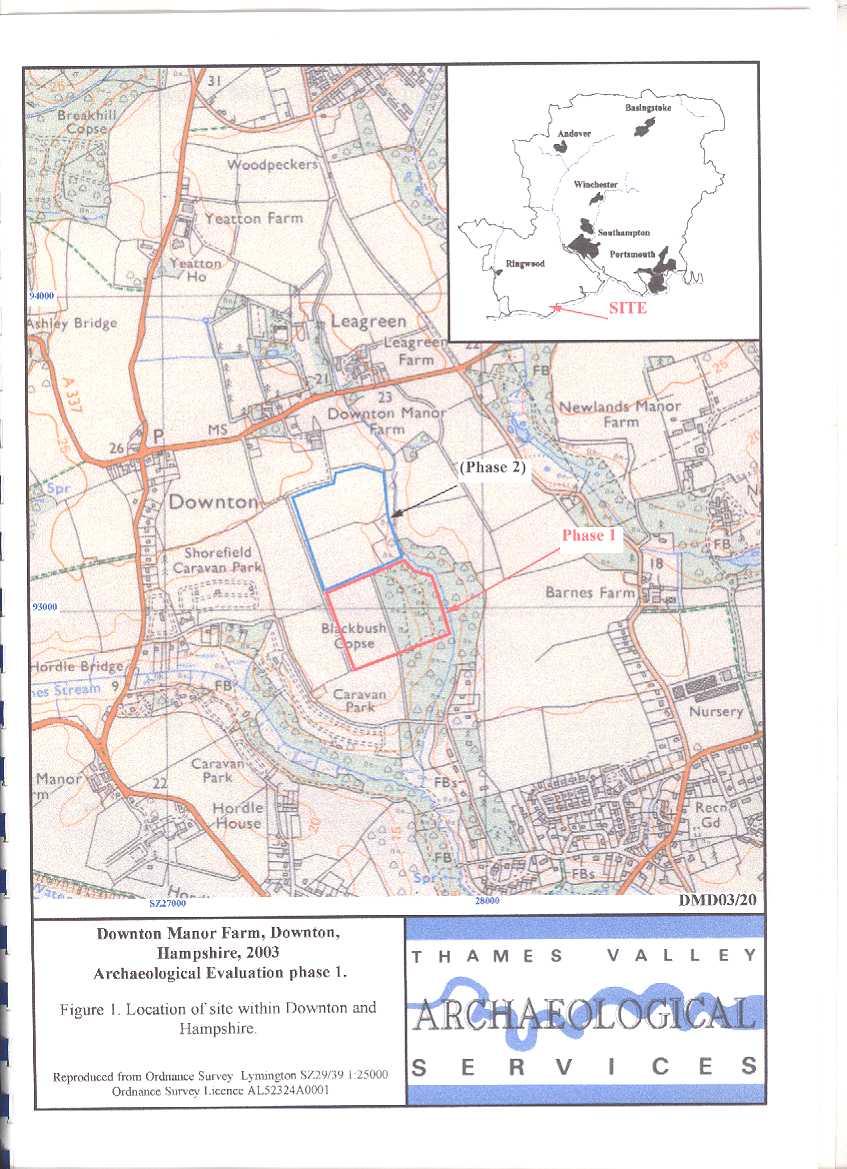
3 Downton Manor, Downton, near Lymington, Hampshire Archaeological Evaluation by Sian Anthony Report 03/20 Introduction This report documents the results of the first phase of archaeological field evaluation carried out at Downton Manor Farm, Downton, near Lymington, Hampshire (Fig. 1). The work was commissioned by Mr John Salmon, Land and Mineral Management Limited, Roundhouse Cottages, Bridge Street, Frome, Somerset, BA11 1BE on behalf of New Milton Sand and Ballast, Caird Avenue, New Milton, Hampshire, BH25 5PX. Planning permission is to be sought from Hampshire County Council for the extraction of sand and gravel on the site. This evaluation and a previous desk-based assessment (WA 2002) were commissioned to investigate the potential impact of these proposals on any archaeology in the area. The site has been divided into two phases, the first consisting of Fields 3 and 4, the second phase of Fields 1 and 2 (Fig. 2). The first phase is described in this report which has been completed to give an indication of the archaeological potential prior to the application for planning permission. The second phase is due to be completed in September The work was undertaken to a specification approved by, and was monitored by, Mr Ian Wykes, Senior Archaeologist, Hampshire County Council. The fieldwork was carried out by Sian Anthony, Julie Cassidy and Steve Ford from 18th April to 8th May The site code is DMD03/20. Location, topography and geology The site is located on the south coast of the New Forest (Fig. 1), on the south side of the A337, Lymington to New Milton Road. It lies to the east of the village of Downton and north-west of Milford-on-Sea. The site comprises four fields all to the south-east of the farm, bounded by a farm track to the west and the remains of Blackbush Copse and a stream to the east. The topography slopes down gently from the north at 25m above Ordnance Datum with occasional gentle undulations, particularly in Field 3. Field 4 shows the most variation with a dramatic slope down from the west to the stream, the land dropping to less than 15m above OD here. This may have been enhanced by modern extraction of gravel for farm use close to the stream. The ground was extremely waterlogged in the area surrounding trenches 49, 50 and 58 closest to the stream. Field 3 is the only field to be deep ploughed, Field 4 was formerly Blackbush Copse, a heavily wooded tract of land bordering the stream. The geology is Hambridge Beds and Bembridge Marls (IGS 1979) with 1
4 overlying fine brown silty clays. Geology observed on the site varied; a fine silty clay brickearth was present in a small layer overlying orange brown gravels in Field 3. Field 4 (formerly Blackbush Copse) consisted of mixtures of silty clay, light grey to brown sands and mixed gravels, there was frequent geological gravel activity and tree root activity obscuring the natural geology. Archaeological background An archaeological desk based assessment highlighted the archaeological importance of the site (WA 2002). There are several points of archaeological interest in the area; none were Scheduled Monuments but many were listed buildings lying to the north of the site. Only two entries in the Sites and Monuments Record lie on the site. They relate to cropmarks observed on an aerial photograph, showing a curvilinear and linear feature in the northeast corner of Field 3. Various other cropmark features were observed throughout this field and field 4, however they were all of indistinct amorphous shape (reproduced on Fig. 3). Many prehistoric stray finds have come from the vicinity indicating widespread human activity from the Palaeolithic onwards, as the site lies on gravel terraces known to be rich in archaeological material. Only stray evidence exists for the Roman period, and none for the Saxon period. Medieval records indicate Downton as a manor from the late 12th century and many of the listed buildings from the village are from this period, although Downton Manor Farm does not appear in maps until the Second Edition of the Ordnance Survey (1898). Objectives and methodology The purpose of the evaluation was to determine the presence/absence, extent, condition, character, quality and date of any archaeological deposits within the area of proposed sand/gravel extraction. Another aim was to investigate both of the anomalies identified by the crop marks found on the aerial photograph. This was to be accomplished by a phased investigation comprising the non-invasive techniques of geophysical survey and field walking, followed by evaluation trenching to target any anomalies or patterns identified by the prior techniques. The possibility of encountering Palaeolithic material was considered as the site lies on one of the gravel terraces of the proto-solent. However, examination of the borehole logs for the site suggested that there were very few locations where in situ Palaeolithic material might be present and that these were deeply buried within the gravel, and at or beyond the margins of the site. Apart from digging more shorter trenches rather than fewer longer trenches to increase the number of sample points for a given sample fraction, the trenching strategy was not specifically designed to search for deeply buried Palaeolithic finds. 2
5 The geophysical survey is fully detailed in Appendix 4. The whole area was scanned by magnetometer on 20m transects and then areas with anomalies were selected for a more detailed survey. Three fields were surveyed using this method; Field 2 was omitted because of the presence of livestock. The fieldwalking was completed using 10m transects aligned on the National Grid with material collected from 10m intervals along these lines. The effect width of search along these transects is 1m and this approximates to a 10% survey of the field area. Collection conditions and other features such as areas of soil discolouration were recorded. Only one field (Field 3) was suitable for fieldwalking as the rest were under pasture. A contingency arrangement for test pits was made available for any investigation of concentrations of flint finds following this initial phase of investigation. The trenches were excavated using a type machine with a 1.8m wide toothless ditching bucket and were intended to be 10m long. This approximated to a 2% sample of the site area. The machine was employed under direct and continuous archaeological supervision to remove turf and topsoil until the relevant archaeological levels were reached. All possible archaeological features were hand cleaned and a selection investigated, and all spoilheaps were monitored for finds. A complete list of trenches giving lengths, breadths, depths and a description of sections and geology is given in Appendix 1. Results Fieldwalking The fieldwalking took place on Field 3 which had been ploughed and harrowed. The ground was dry and was stoney to the east but clayey towards the west. Most of the walking took place in overcast conditions but the west of the area was walked in sunshine. Fieldwalking revealed only a very low level of worked flint and a single piece of pottery. Very rare finds of burnt flint and more modern items were observed but not collected. A modern charcoal patch 3m in diameter and areas of darker soil which coincided with small undulations in the ground were observed on the east side of the field (Fig. 2). Sixteen struck flints were recovered during the fieldwalking, none of which were more closely datable than later Neolithic or Bronze Age. In terms of their distribution they did form a loose cluster on the western side of the field but were spread over more than 2 ha and had a corresponding density of c. 80/ha (extrapolating the figure to assume 100% coverage). This low figure is normally interpreted as background noise and may represent no more than casual loss, or the manuring of arable land (Ford 1987). On flint-poor geological outcrops, low density clustered distributions can indicate the presence of occupation sites, though for this site the 3
6 western extent of the distribution, beyond the site boundary would need to be determined by more fieldwork to explore this possibility further. Geophysics Following the scanning exercise, three areas were chosen for detailed surveying by magnetometer (Areas 3 5) (Fig. 3) though Area 3 lies in the planned second phase of evaluation. Modern agricultural plough scars were evident in all the areas examined. Additional positive anomalies were also considered as of probable modern agricultural origin. Some anomalies were suggested as of possible archaeological origin (Appendix 4). Area 4 was divided into two parts but both parts revealed miscellaneous irregular linear anomalies including plough stripes. Area 5 also revealed plough stripe anomalies but also possible pits and a possible rectilinear ditch. Evaluation trenches (Fig. 3) Field 3 Field 3 was investigated by 45 trenches ranging in length from 3.4m to 19.9m, the longer trenches being necessary to pinpoint the cropmark locations noted on aerial photographs. The stratigraphy was observed to vary only towards the eastern margins of the field. It usually comprised ploughsoil with an average depth of m but ranged overall from 0.4m to just 0.1m at the far eastern end. Deep ploughsoil lay on top of a thinner subsoil mixture of dark brown silty clay with occasional gravel inclusions, this in turn lay above an orange brown silty clay matrix with varying amounts of gravel inclusions, this proving to be the archaeologically relevant layer. Test pits to confirm that this was the correct interpretation proved that deeper stratigraphy consisted of an orange brown gravel onto occasional orange clays and sand. There was more brickearth lying to the western margin of the field, with the subsoil lying directly onto gravels in the east. The presence of brickearth naturals in the west made it necessary to permit the open trenches a period of weathering to allow any potential features to show clearly. There were frequent indications of gravel upsurge and tree root activity showing in the relevant layers, several of these were investigating to confirm they were not archaeologically relevant. Two were recorded (as features 5 and 12) because it was possible that they were of archaeological interest, however later excavation proved them to have a natural origin. Frequent plough scars were noted in the majority of the trenches in this field, many as much as 0.62m below the ground surface confirming the comments made by the farmer on the 4
7 depth of modern ploughing. Five trenches (13, 14, 15, 17, 39) did contain possible archaeological features though a natural origin could not easily be dismissed for some of these (Figs 4 and 5). Trench 13 The trench was sited within a geophysical area covering potential agricultural features. Posthole or small pit (11) was circular, 0.44m in diameter and 0.11m deep, with a flat base. The fill was mid grey silty clay with frequent gravel. It was fully excavated but revealed no finds nor material such as charcoal. Trench 14 The trench lay inside an area scanned for features by the geophysical survey and produced features of possible agricultural origin: frequent plough scars covered the trench. One oval post hole or small pit (10) lay at the northern end of the trench, 0.4m long, 0.27m wide and 0.09m deep, it had a round base and a moderate grey brown fill with frequent gravel inclusions, it was fully excavated but contained no finds nor material such as charcoal. Trench 15 This trench also lay within a scanned area by geophysics. One gully (7) and one posthole or pit (9) were investigated, a further area of tree root activity (8) butted against or cut posthole (9). Gully (7) was 0.42m wide and 0.23m deep with a flat base, it had a moderately firm fill of grey brown silty clay and frequent gravel. Posthole or pit (9) was 0.36m long and 0.43m wide and only 0.09m deep with a flat base and shallow sides, it had a similar fill to gully (7). No finds, nor material such as charcoal were recovered from either feature. Trench 17 Trench 17 lay parallel to the southern margin of the field. No features were apparent from the initial geophysical scan. Seven potential features were located, two are confirmed as postholes (4, 6), a large area at the eastern end of the trench was a tree bole, feature (5) was confirmed as a natural scoop rather than human activity. Three interlinking features may be postholes (1, 2, 3) but these are uncertain. They contained no finds nor material such as charcoal. Posthole (4) was 0.39m in diameter and 0.12m deep with a flat base. Posthole (6) was 0.3m in diameter and 0.1m deep with a round base. Posthole or pit (1) was 0.45m long, 0.26m wide and 0.06m deep, it butted against posthole or pit (2) which is 0.41m long and 0.3m wide with a depth of 0.1m. Posthole (3) also butted against (2) and was 0.37m in diameter with a depth of 0.12m. Features (1, 2, 3) had a similar fill of moderately firm silty 5
8 clay with frequent gravel. It is possible that they represent archaeological features as they were not surrounded by tree root activity, but did not contain any finds nor material such as charcoal to confirm their origin. Trench 39 The furthest north of the trenches containing features was also located closer to the cropmarks and over an area scanned in detail by geophysics. A shallow ditch 1.1m wide and 0.18m deep was excavated (13), the fill was a firm mid grey brown silty clay with frequent gravel inclusions [Plate 2]. The ditch was clearly visible from the surface and had a flat base. No finds were recovered from the fill although a 15 litre sample of the fill was sieved on site for finds and the entire ditch visible in the trench was then excavated. Field 4 Field 4 was of rough pasture ending just before the Blackbush Copse stream to the east. Thirty-four trenches were excavated over the field which ranged in length from 5.6m to 13.2m. Turf and topsoil layers were thin, averaging 0.1m, over a mixed stratigraphy: mid orange brown silty clay was most common in trenches towards the west of the field; further to the east and down the slope towards the stream, the stratigraphy became noticeably more gravelly and mixed with grey sand. Modern land drains filled with modern gravel were common, usually aligned northwest-southeast, draining towards the stream. Tree root activity was frequent throughout the field, particularly towards the east, where the natural levels were mostly totally obscured by it or large amounts of human disturbance. Human disturbance in the form of large holes was evident at the base of the slope close to trenches 48, 49, 50. More human disturbance was evident in trenches 67, 68 and 79, these contained modern metal dumps in the subsoil and natural gravel levels. Trench 72 Turf and topsoil 0.09m deep lay over 0.17m of mid brown silty clay, in this silty clay was recovered a large piece of earlier prehistoric pottery. Despite hand cleaning, no feature was located. Finds Struck flint by Steve Ford Just 16 struck flints were recovered during the fieldwalking programme on field 3 (Appendix 2). These comprised 9 flakes; one of which might have been retouched and one of which is a narrow flake; 2 cores, 2 scrapers and 3 bashed lumps, that is flint nodules with only one or two removals and which are possibly of non- 6
9 archaeological origin. None of the struck flint is chronologically distinctive. It does not obviously contain any earlier (Mesolithic) pieces and is likely to be of later Neolithic or Bronze Age date. Pottery by Steve Ford The evaluation exercise only produced two sherds of pottery in total. 1) One small sherd of black, coarse sand tempered pottery (<10g) was recovered from the fieldwalking in Field 3 and is probably of Iron Age/Roman date. 2) A large, thick (14mm), hand made sherd (64g) was recovered from the subsoil in Trench 72. The outer surfaces are red with a black core. The sherd is poorly fired and is tempered with coarse angular white and grey quartz inclusions. It has no curved surface and may be a large base sherd. It is likely to be of earlier prehistoric (Bronze Age) date. Conclusion The first phase of evaluation on this site has successfully some finds and possible deposits of archaeological origin. Fieldwalking located a small number of prehistoric flints towards the west of Field 3, forming a loose cluster but neither subsequent geophysical survey nor trenching revealed features to allow interpretation of this material as representing Neolithic or Bronze Age occupation. These finds and the single sherd of Iron Age or Roman pottery recovered could represent the manuring of farm land at various times rather than occupation. Geophysical survey over Fields 1, 3 and 4 revealed several possibilities for archaeological activity, but subsequent trenching revealed only natural features such as convolutions in the gravel and modern human disturbance such as ploughing and pit digging (gravel extraction?). Features observed on an aerial photograph identified in the desk-based assessment of the site are now thought to represent this type of activity. Trenching revealed several features of very shallow depth. The observed plough scars frequently encountered over Field 3 indicate deep ploughing which may have contributed to destruction of much of the original depth of these features. The features, which were located in trenches spread across the site area, comprised: a ditch, gully and six postholes or pits. All of these have been excavated in full but unfortunately no dating evidence was recovered. The stray find of prehistoric pottery in Trench 72 is worthy of mention as it is a large and unabraded. However it occurred in isolation and it is unclear if it reflects prehistoric occupation in the vicinity or, as above, is also representative of manuring activity. 7
10 On balance, despite the recovery of some finds of archaeological interest and the possibility that some of these undated deposits are of pre-modern and human origin, the archaeological potential of the site would appear to be relatively low. References Ford, S, 1987, East Berkshire Archaeological Survey, Berkshire County Council Dept Highways and Planning Occas Pap 1, Reading IGS 1979, Geological Map of the United Kingdom South Sheet, 1: , Third Edition Solid. Institute of Geological Sciences PPG16, 1990, Archaeology and Planning, Dept of the Environment Planning Policy Guidance 16, HMSO WA 2002, Downton Manor and Yeatton Farms, New Milton, Hampshire, Archaeological Desk-Based Assessment, Wessex Archaeology report 51312, Salisbury 8
11 APPENDIX 1: Trench details 0m at South or West end Trench No. Length (m) Breadth (m) Depth (m) Comment Topsoil (0.27m) onto dark brown silty clay sub soil (0.18m) onto orange brown silty clay brickearth natural with occasional gravel. Test pit at west end to 0.72m deep confirmed orange brown sand and gravel underneath the brickearth Topsoil (0.25m) onto dark brown silty clay sub soil (0.18m) onto orange brown silty clay brickearth natural with occasional gravel Topsoil (0.2m) onto dark brown silty clay sub soil (0.2m) onto orange brown silty clay brickearth natural with occasional gravel. Frequent plough scars and one tree bole filled with gravel and burnt charcoal Topsoil (0.3m) onto dark brown silty clay sub soil (0.15m) onto orange brown silty clay brickearth natural with occasional gravel. A small burnt patch visible in north end was a tree bole Topsoil (0.24m) onto dark brown silty clay sub soil (0.14m) onto orange brown silty clay brickearth natural with occasional gravel Topsoil (0.28m) onto dark brown silty clay sub soil (0.1m) onto orange brown silty clay brickearth natural with occasional gravel. Pottery found in plough scar at 8m Topsoil (0.23m) onto dark brown silty clay sub soil (0.3m) onto orange brown silty clay brickearth natural with occasional gravel. Frequent plough scars in natural Topsoil (0.3m) onto dark brown silty clay sub soil (0.14m) onto orange brown silty clay brickearth natural with occasional gravel. Frequent plough scars in natural Topsoil (0.26m) onto dark brown silty clay sub soil (0.2m) onto orange brown silty clay brickearth natural with moderate gravel Topsoil (0.4m) onto dark brown silty clay sub soil (0.15m) onto orange brown silty clay brickearth natural with occasional gravel. Frequent plough scars Topsoil (0.3m) onto dark brown silty clay sub soil (0.12m) onto orange brown silty clay brickearth natural with occasional gravel. Frequent plough scars in natural Topsoil (0.36m) onto dark brown silty clay sub soil (0.2m) onto orange brown silty clay brickearth natural with occasional gravel. Natural gravel patches Topsoil (0.32m) onto dark brown silty clay sub soil (0.2m) onto orange brown silty clay brickearth natural with occasional gravel Topsoil (0.26m) onto dark brown silty clay sub soil (0.18m) onto orange brown silty clay brickearth natural with occasional gravel. Frequent plough scars in natural Topsoil (0.33m) onto dark brown silty clay sub soil (0.2m) onto orange brown silty clay brickearth natural with occasional gravel. Ditch aligned NW-SE Topsoil (0.3m) onto dark brown silty clay sub soil (0.18m) onto orange brown silty clay brickearth natural with occasional gravel. Frequent plough scars in natural Topsoil (0.28m) onto dark brown silty clay sub soil (0.1m) onto orange brown silty clay brickearth natural with moderate gravel Topsoil (0.31m) onto dark brown silty clay sub soil (0.2m) onto orange brown silty clay brickearth natural with occasional gravel Topsoil (0.36m) onto dark brown silty clay sub soil (0.18m) onto orange brown gravel natural Topsoil (0.27m) onto dark brown silty clay sub soil (0.18m) onto orange brown silty gravel Topsoil (0.4m) onto dark brown silty clay sub soil (0.22m) onto frequent dark brown gravel and sand. Tree boles Topsoil (0.3m) onto dark brown silty clay sub soil (0.05m) onto orange brown silty clay brickearth natural with moderate gravel. Frequent plough scars in natural and one tree root activity Topsoil (0.4m) onto dark brown silty clay sub soil (0.04m) onto orange silty clay brickearth natural with moderate gravel Topsoil (0.32m) onto dark brown silty clay sub soil (0.05m) onto orange brown silty clay brickearth natural with moderate gravel Topsoil (0.29m) onto dark brown silty clay sub soil (0.16m) onto orange brown gravel onto yellow green sand. Test pit depth to 1.22m. Frequent plough scars Topsoil (0.28m) onto dark brown silty clay sub soil (0.2m) onto orange brown silty clay brickearth natural with moderate gravel. Frequent plough scars Topsoil (0.28m) onto dark brown silty clay sub soil (0.11m) onto 9
12 Trench No. Length (m) Breadth (m) Depth (m) Comment 1.8orange brown silty clay brickearth natural with moderate gravel. Frequent plough scars Topsoil (0.29m) onto dark brown silty clay sub soil (0.19m) onto orange brown silty clay brickearth natural with moderate gravel. Frequent plough scars Topsoil (0.22m) onto dark brown silty clay sub soil (0.18m) onto orange brown silty clay brickearth natural with occasional gravel Topsoil (0.14m) onto dark brown silty clay sub soil (0.35m) onto orange brown silty clay brickearth natural with occasional gravel Topsoil (0.14m) onto dark brown silty clay sub soil (0.23m) onto orange brown frequent gravel Topsoil (0.15m) onto dark brown silty clay sub soil (0.17m) onto orange brown silty gravel Topsoil (0.14m) onto dark brown silty clay sub soil (0.14m) onto orange brown gravel Topsoil (0.16m) onto dark brown silty clay sub soil (0.16m) onto orange brown silty clay brickearth natural with frequent gravel. Frequent plough scars Topsoil (0.1m) onto dark brown silty clay sub soil (0.14m) onto orange brown silty gravel Topsoil (0.14m) onto dark brown silty clay sub soil (0.25m) onto orange brown silty clay brickearth natural with occasional gravel Topsoil (0.13m) onto dark brown silty clay sub soil (0.23m) onto orange brown silty gravel. Frequent plough scars Topsoil (0.14m) onto dark brown silty clay sub soil (0.2m) onto orange brown silty clay brickearth natural with occasional gravel. Plough scar Topsoil (0.09m) onto dark brown silty clay sub soil (0.21m) onto orange brown silty clay brickearth natural with occasional gravel. Frequent plough scars. [Plate 2] Topsoil (0.1m) onto dark brown silty clay sub soil (0.29m) onto orange brown silty gravel. Plough scars Topsoil (0.14m) onto dark brown silty clay sub soil (0.27m) onto orange brown silty clay brickearth natural. Plough scars Topsoil (0.2m) onto dark brown silty clay subsoil (0.14m) onto orange brown silty clay brickearth natural with occasional gravel. Plough scars Topsoil (0.2m) onto dark brown silty clay sub soil (0.11m) onto orange brown silty clay brickearth natural with occasional gravel. Plough scars Topsoil (0.2m) onto dark brown silty clay sub soil (0.12m) onto orange brown silty gravel Topsoil (0.22m) onto dark brown silty clay sub soil (0.24m) onto orange brown silty clay brickearth natural with occasional gravel and gravel patches. Plough scars. [Plate 1] Topsoil (0.1m) onto dark brown silty clay sub soil (0.22m) onto sandy light brown silt (0.23m) onto mid brown silty clay (0.2) onto grey brown sand. Test pit in NW end 0.63m deep Turf (0.16m) onto mid brown subsoil (0.24m) onto frequent gravel natural, test pit in SW shows gravel onto orange clay Turf (0.15m) onto mid brown silty clay(0.19m) onto orange brown silty clay with occasional gravel. Land drain Topsoil (0.19m) onto mid brown silty clay (0.18m) onto orange brown silty gravel with frequent root activity. Land drain, test pit at SW end to 0.61m Topsoil (0.13m) onto mid brown silty clay (0.17m) onto light grey sandy silt with frequent root activity. Land drain at SW Topsoil (0.12m) onto mid brown silty clay (0.09m) onto mid brown sandy gravel with frequent root activity at NW Topsoil (0.09m) onto mid brown silty clay (0.14m) onto dark brown sandy gravel with frequent root activity Topsoil (0.08m) onto mid brown silty clay (0.14m) onto dark brown sandy gravel with frequent root activity Topsoil (0.09m) onto mid brown silty clay (0.13m) onto dark brown sandy gravel with frequent root activity Topsoil (0.1m) onto mid brown silty clay (0.19m) onto dark brown sandy gravel with frequent root activity Topsoil (0.12m) onto mid brown silty clay (0.16m) onto dark brown sandy gravel with frequent root activity Topsoil (0.11m) onto mid brown silty clay (0.14m) onto orange brown silty clay with occasional gravel. Test pit at E end to depth of 0.62m goes on to orange clay Topsoil (0.13m) onto mid brown silty clay (0.11m) onto mid brown 10
13 Trench No. Length (m) Breadth (m) Depth (m) Comment gravel with frequent root activity. Human disturbance at E end Topsoil (0.09m) onto mid brown silty clay (0.11m) onto orange brown silty clay. Modern white china in subsoil Topsoil (0.15m) onto mid brown silty clay (0.1m) onto mid orange brown silty clay with moderate gravel Topsoil (0.13m) onto mid brown silty clay (0.16m) Topsoil (0.1m) onto mid brown silty clay (0.17m) Topsoil (0.08m) onto mid brown silty clay (0.14m) Topsoil (0.1m) onto mid brown silty clay (0.13m). Test pit at north to 0.64m deep onto orange brown gravel Topsoil (0.1m) onto mid brown silty clay (0.14m). Modern land drain Topsoil (0.11m) onto mid brown silty clay (0.24m). Modern land drain Topsoil (0.09m) onto mid brown silty clay (0.16m). Tree root activity Topsoil (0.1m) onto mid brown silty clay (0.13m). Tree root activity Topsoil (0.14m) onto mid brown silty clay (0.21m). Tree boles at East, modern metal in subsoil Topsoil (0.11m) onto mid brown silty clay (0.15m). Test pit to 0.62m onto orange clay and gravel Topsoil (0.06m) onto mid brown silty clay (0.17m) Topsoil (0.09m) onto mid brown silty clay (0.17m). Prehistoric pot found in subsoil Topsoil (0.06m) onto dark grey silty gravel (0.16m) Topsoil (0.09m) onto mid grey moderate gravel (0.22m). Modern land drain Topsoil (0.09m) onto mid brown silty clay with occasional gravel(0.16m) Topsoil (0.07m) onto light orange brown silty clay with occasional gravel (0.11m) Topsoil (0.12m) onto light orange brown silty clay (0.11m). dark grey tree boles at east Topsoil (0.11m) onto mid orange brown silty clay (0.19m), frequent tree root activity. Modern land drain. Modern metal dumped into tree activity Topsoil (0.13m) onto mid brown silty clay (0.2m). Tree root activity at east, modern metal dumped into natural and tree boles. 11
14 APPENDIX 2: Catalogue of struck flint NGR Easting (SZ) Northing Type bashed lump bashed lump Narrow Flake Flake Flake Scraper Scraper Core Flake Core Flake Flake Flake Flake (retouched?) Flake bashed lump 12
15 APPENDIX 3: Catalogue of pottery Trench NGR Easting (SZ) Northing Type (fieldwalked) Sherd, Iron Age/Roman 72 1 Sherd, prehistoric 13
16 APPENDIX 4: Geophysical survey report. 14
17
18
19
20
21
22
23
24
25
26
27
28
29
30
31
32
33
34
35
36
37
38
39
40
41
42
43
44
45
46
47
48
49
50
51
52 Track Downton Manor Farm, Downton, Hampshire, 2003 N Field Field 2 Blackbush Copse Track B B Field 3 Iron Age/Roman pottery Field 4 B S S SZ KEY: B Bashed lump Flake S Scraper Core 0 500m Figure 2. Distribution of fieldwalking finds in Field 3. DMD03/20
53 Downton Manor Farm, Downton, Hampshire, 2003 N Approximate location of cropmarks 49 Blackbush Copse Field 2 (Second Phase) Geophysics area Track Geophysics area Track Field Geophysics area Prehistoric pottery Field SZ m Figure 3. Location of trenches and features in site, cropmarks and detailed areas of geophysical scanning are in grey. DMD03/20
54 Downton Manor, Downton, Hampshire, 2003 N Trench 17 5 (natural scoop) m 4m 6m 8m 10m 3 4 Tree bole Trench Tree bole 4m 6m N Trench 14 Trench 13 N 8m 10m 9m 10 N 11 Trench 39 N 3m 4m m Figure 4. Plans of features. DMD03/20
55 Downton Manor, Downton, Hampshire, 2003 N S NE 54 4 SW N 5 S N 56 6 S SW NE Plough soil W E Subsoil N S W E E W Plough soil Subsoil m Figure 5. Sections of features. DMD03/20

, Trench 39, looking")
56 Plate 1. Trench 45, looking north west, scale 2m Plate 2. Ditch (13), Trench 39, looking west, scales 0.5m and 0.1m DMD03/20
Land at Downsview Avenue, Storrington, West Sussex
 Land at Downsview Avenue, Storrington, West Sussex An Archaeological Evaluation for Bellwinch Homes Limited by Andy Taylor Thames Valley Archaeological Services Ltd Site Code DAS 04/21 March 2004 Summary
Appletree, Thames Street, Sonning Berkshire
 Appletree, Thames Street, Sonning Berkshire An Archaeological Watching Brief for Mr and Mrs A Popham by Sian Anthony Thames Valley Archaeological Services Ltd Site Code ATS 02/83 October 2002 Summary Site
Northbury Farm, Castle End Road, Ruscombe, Berkshire
 Northbury Farm, Castle End Road, Ruscombe, Berkshire An Archaeological Watching Brief For Sir Colin and Lady Southgate by Danielle Milbank Thames Valley Archaeological Services Ltd Site Code NFR 07/120
Land adjacent to Dingle Dock, Front Street, East Garston
 Land adjacent to Dingle Dock, Front Street, East Garston An Archaeological Watching Brief for Dr J Davies by Jo Pine Thames Valley Archaeological Services Site Code DEG99/82 January 2000 Summary Site name:
Ivol Buildings, Woodcote Road, South Stoke, Oxfordshire
 Ivol Buildings, Woodcote Road, South Stoke, Oxfordshire An Archaeological Watching Brief For Christ Church, Oxford by Pamela Jenkins Thames Valley Archaeological Services Ltd Site Code IBSS 04/03 March
Garage Site, Foots Cray High Street, Sidcup, Kent, London Borough of Bexley
 Garage Site, Foots Cray High Street, Sidcup, Kent, London Borough of Bexley An Archaeological Evaluation for Mizen Design Build by Andy Taylor Thames Valley Archaeological Services Ltd FOC 07 September
Meales Farm, Sulhamstead, West Berkshire
 Meales Farm, Sulhamstead, West Berkshire An Archaeological Watching Brief For Mr. Robert Astor by Steve Ford Thames Valley Archaeological Services Ltd Site Code CHH02/29 May 2002 Summary Site name: Meales
ARCHAEOLOGICAL S E R V I C E S. Land north of Orchard Close, Hallow, Worcestershire. Archaeological Evaluation. by Kyle Beaverstock
 T H A M E S V A L L E Y ARCHAEOLOGICAL S E R V I C E S Land north of Orchard Close, Hallow, Worcestershire Archaeological Evaluation by Kyle Beaverstock Site Code: OCW15/224 (SO 8285 5848) Land north of
ARCHAEOLOGICAL S E R V I C E S. Hurley Manor, High Street, Hurley, Berkshire. Archaeological Evaluation. by James McNicoll-Norbury
 T H A M E S V A L L E Y ARCHAEOLOGICAL S E R V I C E S Hurley Manor, High Street, Hurley, Berkshire Archaeological Evaluation by James McNicoll-Norbury Site Code: HMH14/51 (SU 8252 8378) Hurley Manor,
Merrowdene, Earleydene, Sunninghill, Berkshire
 Merrowdene, Earleydene, Sunninghill, Berkshire An Archaeological Watching Brief For Mr and Mrs Jackson by Andy Taylor Thames Valley Archaeological Services Ltd Site Code MES 05/88 January 2006 Summary
Chitty Farmhouse Extension, Wall Lane, Silchester, Hampshire
 Chitty Farmhouse Extension, Wall Lane, Silchester, Hampshire An Archaeological Watching Brief For In Touch by Andrew Mundin Thames Valley Archaeological Services Ltd Site Code CFS 08/52 May 2008 Summary
Pinnocks Wood Equestrian Centre, Burchett s Green, Maidenhead, Berkshire
 Pinnocks Wood Equestrian Centre, Burchett s Green, Maidenhead, Berkshire An Archaeological Watching Brief For Mr David Eyles by Andrew Mundin Thames Valley Archaeological Services Ltd Site Code POB 08/69
New horse training area, Manor Farm, Great Kimble, Buckinghamshire
 New horse training area, Manor Farm, Great Kimble, Buckinghamshire An Archaeological Watching Brief For Redwing Structures (Marlow) Limited by Andy Taylor Thames Valley Archaeological Services Ltd Site
New Media Building, Goldsmiths College, New Cross, London Borough of Lewisham
 New Media Building, Goldsmiths College, New Cross, London Borough of Lewisham An Archaeological Evaluation for Willmott Dixon Construction by Andy Taylor Thames Valley Archaeological Services Ltd Site
Newcombe House & Kensington Church Street
 Newcombe House & Kensington Church Street Archaeological Evaluation September 2017 Summary Site name: Newcombe House, Kensington Church Street, Notting Hill, London Grid reference: TQ 25318 80372 Site
ARCHAEOLOGICAL EVALUATION AT THE FORMER WATTON GARDEN CENTRE, NORWICH ROAD, WATTON, NORFOLK OCTOBER 2003 (Accession number WAT)
") NORTHAMPTONSHIRE ARCHAEOLOGY NORTHAMPTONSHIRE COUNTY COUNCIL NOVEMBER 2003 (Planning Application No: 3PL/1997/048/0 ARCHAEOLOGICAL EVALUATION AT THE FORMER WATTON GARDEN CENTRE, NORWICH ROAD, WATTON, NORFOLK
NORTHAMPTONSHIRE ARCHAEOLOGY NORTHAMPTONSHIRE COUNTY COUNCIL NOVEMBER 2003 (Planning Application No: 3PL/1997/048/0 ARCHAEOLOGICAL EVALUATION AT THE FORMER WATTON GARDEN CENTRE, NORWICH ROAD, WATTON, NORFOLK
ARCHAEOLOGICAL S E R V I C E S. Manor Farm, Launton, Bicester, Oxfordshire. Archaeological Watching Brief. by Aiji Castle. Site Code: LBO13/220
 T H A M E S V A L L E Y ARCHAEOLOGICAL S E R V I C E S Manor Farm, Launton, Bicester, Oxfordshire Archaeological Watching Brief by Aiji Castle Site Code: LBO13/220 (SP 6035 2285) Manor Farm, Launton, Bicester,
New Swimming Pool,West Meon House, West Meon, Hampshire
 New Swimming Pool,West Meon House, West Meon, Hampshire An Archaeological watching brief and building recording for Mr and Mrs Younger by Danielle Milbank Thames Valley Archaeological Services Ltd Site
MONITORING REPORT: No. 283
 MONITORING REPORT: No. 283 Dunluce Castle Visitor Centre Option Site D Magheracross Co. Antrim AE/14/109E Dermot Redmond List of Contents Site Specific Information 1 Account of the Monitoring 2 Discussion
Archaeological Evaluation and Assessment of Land at Kent Cottage, 19 Chapel Street, Hythe, Kent
 Archaeological Evaluation and Assessment of Land at Kent Cottage, 19 Chapel Street, Hythe, Kent Planning Application Y13/0463/SH Date of Report: 29/04/2015 Report for Marc Carney SWAT. ARCHAEOLOGY Swale
ARCHAEOLOGICAL S E R V I C E S. Becks, Park Lane, North Newington, Banbury, Oxfordshire. Archaeological Watching Brief.
 T H A M E S V A L L E Y ARCHAEOLOGICAL S E R V I C E S Becks, Park Lane, North Newington, Banbury, Oxfordshire Archaeological Watching Brief by Andy Mundin Site Code: BPN16/105 (SP 4207 3978) Becks, Park
Archaeological evaluation at Willowdene, Chelmsford Road, Felsted, Essex
 Archaeological evaluation at Willowdene, Chelmsford Road, Felsted, Essex August 2013 report prepared by Ben Holloway on behalf of Mr Anthony McGurren Planning reference: UTT/13/0235 CAT project ref.: 13/07g
Bridge House, Ham Island, Old Windsor, Berkshire
 Bridge House, Ham Island, Old Windsor, Berkshire An Archaeological Watching Brief for Mr A Chadwick by Alan Ford Thames Valley Archaeological Services Site Code BHHI98/55 August 1998 Bridge House, Ham
Monitoring Report No. 166
 Monitoring Report No. 166 No. 2a Loughadian Road Poyntzpass County Down AE/08/189 Nick Beer Site Specific Information Site Address: 2a Loughadian Road, Poyntzpass. Townland: Loughadian SMR No.: DOW 033:034
Windsor Berkshire. Archaeological Watching Brief. King Edward VII Car Park Extension. Archaeological Watching Brief Report
 King Edward VII Car Park Extension Windsor Berkshire Archaeological Watching Brief Report March 202 Client: Royal Borough of Windsor and Maidenhead Issue No: OA Job No: 5242 NGR: SU 972 779 Archaeological
Archaeological Evaluation and Assessment of Land at Minnis Beeches, Canterbury Road, Swingfield, Dover, Kent
 Archaeological Evaluation and Assessment of Land at Minnis Beeches, Canterbury Road, Swingfield, Dover, Kent NGR: TQ 6307 1545 Site Code: MB-EV-10 (Planning Consent Y10/0311/SH) Report for Thorndene Ltd.
Old Town Hall, Market Place, Faringdon, Oxfordshire
 Old Town Hall, Market Place, Faringdon, Oxfordshire Building Recording and Archaeological Watching Brief for Great Faringdon War Memorial Trust by Jamie Preston and Steve Ford Thames Valley Archaeological
Archaeological trial-trenching evaluation: New Hall School, The Avenue, Boreham, Essex. July 2015
 Archaeological trial-trenching evaluation: New Hall School, The Avenue, Boreham, Essex report prepared by Ben Holloway on behalf of New Hall School Planning reference: 14/01846/FUL CAT project ref.: 15/04i
Oak Tree Fields, Spine Road, South Cerney, Gloucestershire
 Oak Tree Fields, Spine Road, South Cerney, Gloucestershire An Archaeological Desk-Based Assessment for Hills Minerals & Waste by Steve Ford Thames Valley Archaeological Services Ltd Site Code OTF04/73
Centre for Archaeological Fieldwork Evaluation/Monitoring Report No Monitoring Report No. 201
 Monitoring Report No. 201 Land adjacent to 58 Drumreagh Road Drumreagh Ballygowan Co. Down LICENCE NO.: AE/10/91E BRIAN SLOAN 1 Site Specific Information Site Name: Land adjacent to 58 Drumreagh Road,
T H A M E S V A L L E Y S E R V I C E S. Flood Compensation Area, Riverside Park, Wallingford, Oxfordshire. Archaeological Watching Brief
 T H A M E S V A L L E Y ARCHAEOLOGICAL S E R V I C E S Flood Compensation Area, Riverside Park, Wallingford, Oxfordshire Archaeological Watching Brief by Jacqueline Pitt Site Code: RPW10/72 (SU 6112 8934)
What is fieldwalking?
 Cambridge Archaeology Field Group May 2012 What is fieldwalking? Archaeological fieldwalking (or Surface Artefact Collection as it is sometimes known) is the systematic recovery and recording of artefacts
Glue Pot Farm, Edwards Lane, Bramfield, Suffolk. BMF 024
 Glue Pot Farm, Edwards Lane, Bramfield, Suffolk. BMF 024 Archaeological Evaluation Report SCCAS Report No. 2013/107 Client: Keith Frost Architectural Design Services Author: Linzi Everett August 2013 SCCAS
Land South-West of Mill Co age, Gidding Road, Sawtry, Cambridgeshire Evalua on Report
 Land South-West of Mill Coage, Gidding Road, Sawtry, Cambridgeshire Evaluaon Report August 2017 Client: CgMs Consulng Issue No: 1 OA East Report No: 2080 NGR: TL 1623 8329 Oxford Archaeology Ltd i 3 August
Archaeological Investigation in advance of Development at 2 Palace Cottages, Charing Palace, Charing, Kent
 Archaeological Investigation in advance of Development at 2 Palace Cottages, Charing Palace, Charing, Kent Site Code CHAR-EV-14 NGR 95412 49439 Date of Report 18/12/2014 Swale and Thames Archaeological
Malden Green Farm, Worcester Park, Surrey, Royal Borough of Kingston
 Malden Green Farm, Worcester Park, Surrey, Royal Borough of Kingston An Archaeological Evaluation and Desk-Based Assessment for Bewley Homes by Steve Ford Thames Valley Archaeological Services Site Code
6A St John s Road, Wallingford Oxfordshire
 6A St John s Road, Wallingford Oxfordshire An Archaeological Evaluation Stage 2 for Spearcliff Estates Ltd by Steve Ford Thames Valley Archaeological Services Ltd Site SJW03/116 January 2004 Summary Site
An Archaeological Evaluation at Granta Cottages, Newmarket Road, Great Chesterford, Essex. August 2015
 An Archaeological Evaluation at Granta Cottages, Newmarket Road, Great Chesterford, Essex August 2015 by Pip Parmenter and Ben Holloway on behalf of Mr G Elmer and Mrs L King CAT project ref.: 15/06a NGR:
Elm Park, Station Road, Ardleigh, Essex, CO7 7RT: archaeological watching brief on installation of new water pipe
 Elm Park, Station Road, Ardleigh, Essex, CO7 7RT: archaeological watching brief on installation of new water pipe November 2015 report prepared by Howard Brooks BA FSA MCIfA on behalf of Partnerships in
MONITORING REPORT: No. 276
 MONITORING REPORT: No. 276 Between 51 and 53 Castor Bay Road Lurgan Co. Armagh AE/13/214 Dermot Redmond Site Specific Information Site Name: Between 51 and 53 Castor Bay Road, Lurgan, Co. Armagh Townland:
Archaeological Monitoring of Land at 29 Royal Pier Road, Gravesend, Kent
 Archaeological Monitoring of Land at 29 Royal Pier Road, Gravesend, Kent Site Code ROY/WB/15 Report for Dr Maxted Date of report 06/10/2015 SWAT ARCHAEOLOGY Swale and Thames Archaeological Survey Company
Evaluation/Monitoring Report No. 243
 60m NORTH OF 64 BALLYGROOBANY ROAD BALLYNAHINCH RICHHILL COUNTY ARMAGH LICENCE NO.: AE/12/91E NAOMI CARVER 1 Site Specific Information Site Name: site 60m north of 64 Ballygroobany Road, Ballynahinch,
Archaeological monitoring at Clintons, Bury Green, Little Hadham, Hertfordshire April 2008
 Archaeological monitoring at Clintons, Bury Green, Little Hadham, Hertfordshire April 2008 report prepared by Ben Holloway on behalf of Charles Britton Equestrian Construction CAT project ref.: 08/3b NGR:
EVALUATION REPORT No. 300
 EVALUATION REPORT No. 300 Southwest of 2A Cloughey Road, Portaferry, Co. Down Licence No.: AE/135/85E Sapphire Mussen Report Date: 14 th May 2015 Site Specific Information Site Name: [Southwest of 2a]
Archaeological evaluation at Redbank, Bury Water Lane, Newport, Essex, CB11 3TZ
 Archaeological evaluation at Redbank, Bury Water Lane, Newport, Essex, CB11 3TZ March 2017 by Laura Pooley figures by Ben Holloway and Emma Holloway fieldwork by Ben Holloway with Harvey Furniss and Elliott
Monitoring of invasive groundworks ahead of the installation of a septic tank at 16a, 16b and 16c Donegore Hill Muckamore County Antrim
 Monitoring Report No. 177 Monitoring of invasive groundworks ahead of the installation of a septic tank at 16a, 16b and 16c Donegore Hill Muckamore County Antrim LICENCE NO.: AE/09/48 Brian Sloan 1 Site
Epsom Water Works, East Street, Epsom, Surrey
 Epsom Water Works, East Street, Epsom, Surrey An Archaeological Desk-Based Assessment for St James Homes Ltd by Steve Ford Thames Valley Archaeological Services Site Code ESE99/85 December 1999 Epsom Water
Archaeological evaluation at Stables, Hatch Farm, Fen Lane, Bulphan, Essex, RM14 3RL
 Archaeological evaluation at Stables, Hatch Farm, Fen Lane, Bulphan, Essex, RM14 3RL November-December 2016 by Laura Pooley figures by Ben Holloway and Emma Holloway fieldwork by Ben Holloway and Alec
Gryme s Dyke, Stanway Green
 Gryme s Dyke, Stanway Green A short assessment of the archaeological impact of contractor s groundworks at the southern end of the Gryme s Dyke Middle earthwork February 2000 Archive report on behalf of
MONITORING REPORT: No. 289
 MONITORING REPORT: No. 289 21 Ballynarrig Road Ballydarrog Co. Derry AE/14/213E Dermot Redmond Site Specific Information Site Name: 21 Ballynarrig Road, Limavady Townland: Ballydarrog SMR No. : LDY 016:004
A Research Framework for the Archaeology of Wales Version 01, Final Paper Neolithic and Earlier Bronze Age
 NEOLITHIC AND EARLIER BRONZE AGE Introduction The introduction of farming around 4000 BC had a dramatic impact on the landscape of Wales and fundamentally changed they ways in which people lived and interacted.
Archaeological evaluation: land to the rear of Clare Road, Braintree, Essex
 Archaeological evaluation: land to the rear of 41-45 Clare Road, Braintree, Essex March 2014 commissioned by Mr Mark Plummer report prepared by Ben Holloway and Howard Brooks Planning reference: 13/000585/FUL,
Monitoring Report No. 168
 Monitoring Report No. 168 Loughgall Presbyterian Church Cloven Eden Loughgall County Armagh AE/08/203 Nick Beer Site Specific Information Site Address: Loughgall Presbyterian Church, 100 Cloven Eden Road,
Evaluation/monitoring Report No. 241 KING S CASTLE NURSING HOME ARDGLASS CO. DOWN AE/12/19 SARAH GORMLEY
 Evaluation/monitoring Report No. 241 KING S CASTLE NURSING HOME ARDGLASS CO. DOWN AE/12/19 SARAH GORMLEY 1 Site Specific Information Site Name: Townland: King s Castle Ardglass SMR No. : DOW 045:024 Status:
White Cliffs Business Park, Dover, Kent
 White Cliffs Business Park, Dover, Kent Archaeological Desk-Based Assessment Report Project Code: WCBP-DA-15 Planning Ref: Pre-application NGR: 631378 144379 Report No: 2016/4 Archive No: 3671 July 2016
Archaeological evaluation on land at Mersea Fleet Way, Chelmer Road, Braintree, Essex, CM7 3PZ
 Archaeological evaluation on land at Mersea Fleet Way, Chelmer Road, Braintree, Essex, CM7 3PZ by Laura Pooley figures by Ben Holloway and Emma Holloway fieldwork by Ben Holloway, Robin Mathieson, Nigel
AGRICULTURAL LAND CLASSIFICATION
 AGRICULTURAL LAND CLASSIFICATION GOOLE/HOOK LOCAL PLAN SITES SURVEYED FOR BOOTHFERRY BOROUGH COUNCIL'S INDUSTRIAL LAND SUITABILITY STUDY ADAS February 1991 Leeds Regional Office 2FCS 5205 CONTENTS 1. Introduction
Centre for Archaeological Fieldwork, School of Archaeology and Palaeoecology, Queen s University Belfast.
 Centre for Archaeological Fieldwork, School of Archaeology and Palaeoecology, Queen s University Belfast. Monitoring Report No. 04 Duneight Motte and Bailey, May 2004. On behalf of Monitoring Report: Duneight
STATEMENT OF PHYSICAL CHARACTERISTICS OLDWICK FARM, WEST LAVANT, WEST SUSSEX
 STATEMENT OF PHYSICAL CHARACTERISTICS OLDWICK FARM, WEST LAVANT, WEST SUSSEX STATEMENT OF PHYSICAL CHARACTERISTICS OLDWICK FARM, WEST LAVANT, WEST SUSSEX 1. BACKGROUND 1.1 This 37.1 ha site was surveyed
STATEMENT OF PHYSICAL CHARACTERISTICS AND AGRICULTURAL LAND CLASSIFICATION
 STATEMENT OF PHYSICAL CHARACTERISTICS AND AGRICULTURAL LAND CLASSIFICATION BIRKWOOD FARM, ALTOFTS WEST YORKSHIRE Proposed Opencast Extraction of Clay and coal ADAS January 1990 Leeds Regional Office File
Archaeological Evaluation and Assessment of Land at the Duke of Kent site, Staple Street, Faversham, Kent September 2011
 Archaeological Evaluation and Assessment of Land at the Duke of Kent site, Staple Street, Faversham, Kent September 2011 SWAT. Archaeology Swale and Thames Archaeological Survey Company School Farm Oast,
PHYSICAL CHAtlACTERISTICS REPORT FOR THE PROPOSED SAND AND GRAVEL SITE AT MANOR FARM, UFFINGTON
 PHYSICAL CHAtlACTERISTICS REPORT FOR THE PROPOSED SAND AND GRAVEL SITE AT MANOR FARM, UFFINGTON Introduction Following the" request for detailed information on the physical characteristics of soil at Manor
Archaeological evaluation at New Hall School, The Avenue, Boreham, Chelmsford, Essex, CM3 3HS
 Archaeological evaluation at New Hall School, The Avenue, Boreham, Chelmsford, Essex, CM3 3HS December 2016 by Laura Pooley with contributions by Stephen Benfield figures by Ben Holloway and Emma Holloway
69 DRUMLOUGH ROAD, DRUMGATH, COUNTY DOWN
 MONITORING REPORT NO. 223 69 DRUMLOUGH ROAD, DRUMGATH, COUNTY DOWN LICENCE NO. EMILY MURRAY Report Date: 13 th April 2011 Site Specific Information Site name: Townland: SMR No. : Grid ref.: County: Excavation
Bridge Road, Maidenhead, Berkshire
 Bridge Road, Maidenhead, Berkshire An Archaeological Desk-Based Assessment for Salmon Harvester Properties Ltd by Steve Ford Thames Valley Archaeological Services Ltd Site Code BRM04/56 June 2004 Summary
PROPOSED DEVELOPMENT AT BRITANNIA PARK, BANGOR
 PROPOSED DEVELOPMENT AT BRITANNIA PARK, BANGOR ARCHAEOLOGICAL MITIGATION WORK Report No. 446 [08] [04] [06] [08] [06] [04] Prepared for Watkins Jones Construction March 2002 By J. Kenney Ymddiriedolaeth
Archaeological evaluation on land at Unit 1, Waltham Hall, Bambers Green Road, Takeley, Essex, CM22 6PF
 Archaeological evaluation on land at Unit 1, Waltham Hall, Bambers Green Road, Takeley, Essex, CM22 6PF by Laura Pooley figures by Ben Holloway and Emma Holloway fieldwork by Ben Holloway with Jane Roberts
AGRICULTURAL LAND CLASSIFICATION AND SOIL PHYSICAL CHARACTERISTICS LAND NEAR SHIRE HILL FARM SAFFRON WALDEN ESSEX
 AGRICULTURAL LAND CLASSIFICATION AND SOIL PHYSICAL CHARACTERISTICS LAND NEAR SHIRE HILL FARM SAFFRON WALDEN ESSEX AGRICULTURAL LAND CLASSIFICATION (ALC) AND SOIL PHYSICAL CHARACTERISTICS LAND NEAR SHIRE
The entire site supports grass on which sheep had been grazing recently.
 PHYSICAL CHARACTERISTICS REPORT FOR LAND AT HORSEHAY A^ Agricultural Land Classification of approximately 14 hectares of land to the southwest of Horsehay was undertaken in November 1989. The site lies
AN ARCHAEOLOGICAL SURVEY FOR THE NAVIDAD RESOURCES, LLC FERGUSON STATE PRISON FARM UNIT PROJECT IN MADISON COUNTY, TEXAS
 AN ARCHAEOLOGICAL SURVEY FOR THE NAVIDAD RESOURCES, LLC FERGUSON STATE PRISON FARM UNIT PROJECT IN MADISON COUNTY, TEXAS Antiquities Permit 5714 By William E. Moore Brazos Valley Research Associates Contract
Archaeological Watching Brief
 Barrack Block Drainage Hampton Court Palace Archaeological Watching Brief Report May 2012 Client: Historic Royal Palces Issue No: 1 OA Job No: 5329 NGR: TQ 15485 168587 Archaeological Watching Brief Archaeological
PHYSICAL CHARACTERISTICS REPORT INCORPORATING AGRICULTURAL LAND CLASSIFICATION LAND AT BOLE INGS, WESTBURTON, NOTTINGHAMSHIRE (SK805875)
") (krahs 2% I?5 PHYSICAL CHARACTERISTICS REPORT INCORPORATING AGRICULTURAL LAND CLASSIFICATION LAND AT BOLE INGS, WESTBURTON, NOTTINGHAMSHIRE (SK805875) 1.0 INTRODUCTION 1.1 The site, an area of 84.5 hectares,
(krahs 2% I?5 PHYSICAL CHARACTERISTICS REPORT INCORPORATING AGRICULTURAL LAND CLASSIFICATION LAND AT BOLE INGS, WESTBURTON, NOTTINGHAMSHIRE (SK805875) 1.0 INTRODUCTION 1.1 The site, an area of 84.5 hectares,
AGRICULTURAL LAND CLASSIFICATION AND STATEMENT OF PHYSICAL CHARACTERISTICS
 AGRICULTURAL LAND CLASSIFICATION AND STATEMENT OF PHYSICAL CHARACTERISTICS DALE PIT FARM. HATFIELD VOODHOUSE PROPOSED EXTRACTION OF SAND AHD GRAVEL ADAS April 1989 Leeds Regional office File Ref: 2FCS
AGRICULTURAL LAND CLASSIFICATION AND SOIL PHYSICAL CHARACTERISTICS BIRCH PIT, NEAR COLCHESTER ESSEX
 AGRICULTURAL LAND CLASSIFICATION AND SOIL PHYSICAL CHARACTERISTICS BIRCH PIT, NEAR COLCHESTER ESSEX AGRICULTURAL LAND CLASSIFICATION AND SOIL PHYSICAL CHARACTERISTICS SEMI-DETAILED SURVEY BIRCH PIT, NEAR
30 48 Castle Street, High Wycombe, Buckinghamshire
 30 48 Castle Street, High Wycombe, Buckinghamshire An Archaeological Desk-Based Assessment for George Wimpey (West London) Ltd by Jennifer Lowe Thames Valley Archaeological Services Ltd Site Code CHW07/20
13.0 ARCHAEOLOGY AND CULTURAL HERITAGE
 13.0 ARCHAEOLOGY AND CULTURAL HERITAGE Introduction 13.1 This chapter of the ES assesses the likely significant effects of the Overall Development in terms of archaeology and cultural heritage and is supported
How we find the sites
 How we find the sites Many of the archaeological sites mapped by aerial archaeologists have been levelled by ploughing and are identified from the photos as cropmarks or soilmarks. Archaeological sites
2014 Iowa FFA Soil Judging CDE Exam
 2014 Iowa FFA Soil Judging CDE Exam 1. Landscape position is one aspect of evaluating the surface features of a certain tract of land. Identifying the correct landscape position will indicate: a. If the
Examining soils in the field. Examining soils in the field. Environment Agency thinksoils examining soils in the field
 Examining soils in the field thinksoils Examining soils in the field Environment Agency thinksoils examining soils in the field 31 Examining soils in the field 32 Environment Agency thinksoils examining
Bedwell Park, Essendon, Hatfield, Hertfordshire
 Bedwell Park, Essendon, Hatfield, Hertfordshire An Archaeological Desk-Based Assessment for Millgate Homes by Steve Preston Thames Valley Archaeological Services Ltd Site Code BPE06/34 March 2006 Summary
Historic England Advice Report 26 August 2016
 Case Name: Kingsland Castle Case Number: 1435892 Background Historic England has been asked to review the scheduling for Kingsland Castle. The land on which the monument lies is understood to be for sale.
PROPOSED OPEN CAST COAL SITE SEPTEMBER 1992
 AGRICULTURAL LAND CLASSIFICATION AND STATEMENT OF PHYSICAL CHARACTERISTICS SKIERS SPRING, HOYLAND, SOUTH YORKSHIRE PROPOSED OPEN CAST COAL SITE SEPTEMBER 1992 ADAS LEEDS STATUTORY GROUP Job No. 98/92 MAFF
Proposed Retirement Village Cole Green Way, Hertford. Archaeology Statement
 RETIREMENT LIVING MADE BETTER Proposed Retirement Village Cole Green Way, Hertford Archaeology Statement Woodlands Retirement Village RETIREMENT LIVING MADE BETTER Retirement Living Made Better Archaeology
Archaeological Watching Brief Report
 New Playing Fields and Athletics Track Stowe School Buckinghamshire Archaeological Watching Brief o a July 2009 client logo Client: Stowe School Issue N o : 1 OA Job N o : 4167 NGR: SP 679 380 Archaeological
SOIL SURVEY OF PORTIONS 81 AND 82 OFTHE FARM VAALBANK 512JQ, NEAR MAGALIESBURG, SOUTH-WEST OF PRETORIA
 REPORT For Newtown Landscape Architects SOIL SURVEY OF PORTIONS 81 AND 82 OFTHE FARM VAALBANK 512JQ, NEAR MAGALIESBURG, SOUTH-WEST OF PRETORIA By N.M. Mushia, D.G. Paterson and S.D. Mkula Report Number
Interim Statement on Archaeological Evaluation on land immediately to the east of the Manor Lodge, Manor Lane, Sheffield, South Yorkshire
 Archaeological Research & Consultancy at the University of Sheffield Research School of Archaeology West Court 2 Mappin Street Sheffield S1 4DT Phone 0114 2225106 Fax 0114 2797158 Interim Statement 1107.2
Report on a soil survey and agricultural suitability investigation of the property known as Erf 660, De Doorns.
 De Doorns erf 660 Soil Report 1 Report on a soil survey and agricultural suitability investigation of the property known as Erf 660, De Doorns. by F. Ellis September 2006 CONTENTS 1 INTRODUCTION AND TERMS
Archaeological monitoring and recording at 26 Beaver Close, Colchester, Essex, CO3 9DZ
 Archaeological monitoring and recording at 26 Beaver Close, Colchester, Essex, CO3 9DZ May 2017 by Adam Tuffey and Laura Pooley figures by Sarah Carter, Chris Lister and Adam Tuffey fieldwork by Alec Wade
Team number Page 1 of Canon Envirothon Soils Station Test. Soils and Climate Change
 Team number Page 1 of 9 2006 Canon Envirothon Soils Station Test Soils and Climate Change There are many kinds of soil on the surface of the earth. The kind of soil that is present at a given location
Archaeological monitoring and recording at 20 St Peter's Road, West Mersea, Essex, CO5 8LJ
 Archaeological monitoring and recording at 20 St Peter's Road, West Mersea, Essex, CO5 8LJ November 2016 by Laura Pooley figures by Ben Holloway and Emma Holloway fieldwork by Ben Holloway on behalf of
XSW11, Plumstead Portal worksites, Interim Statement for NLBH. 1 Introduction Site Methodology and fieldwork objectives...4
 Contents 1 Introduction...4 2 Site Methodology and fieldwork objectives...4 2.1 NLBH Methodology... 4 2.2 NLBH Fieldwork Objectives... 5 3 Provisional Results...6 3.1 NLBH various features... 6 3.2 Shelter
Land Adjacent to Carsons Drive, Great Cornard
 ARCHAEOLOGICAL DESK BASED ASSESSMENT Land Adjacent to Carsons Drive, Great Cornard (Planning app. no. Pre-planning) James Rolfe Field Team Suffolk C.C. Archaeological Service December 2007 Lucy Robinson,
Archaeological monitoring and recording at 24 St Peter's Road, West Mersea, Essex, CO5 8LJ
 Archaeological monitoring and recording at 24 St Peter's Road, West Mersea, Essex, CO5 8LJ April 2017 by Dr Elliott Hicks figures by S Carter fieldwork by Adam Wightman on behalf of Brett Lord NGR: TM
Faversham Society Archaeological Research Group. The Davington Mysteries
 1 Faversham Society Archaeological Research Group The Davington Mysteries Report for Keyhole Excavation 71B at 4, Stephens Close, Davington, Faversham, Kent Grid Reference: TR 00969 61658 2 Introduction
Archaeological Monitoring of Land to the rear of The Ridges, Valley Drive, Gravesend, Kent
 Archaeological Monitoring of Land to the rear of The Ridges, Valley Drive, Gravesend, Kent NGR: 566215 170479 Site Code RIDGE/WB/14 Report for Mr Sall Date of report 27/03/2014 SWAT ARCHAEOLOGY Swale and
AGRICULTURAL LAND CLASSIFICATION SEMI-DETAILED SURVEY EGG FARM KINGS LANGLEY HERTFORDSHIRE
 AGRICULTURAL LAND CLASSIFICATION SEMI-DETAILED SURVEY EGG FARM KINGS LANGLEY HERTFORDSHIRE AGRICULTURAL LAND CLASSIFICATION SEMI-DETAILED SURVEY EGG FARM, KINGS LANGLEY, HERTFORDSHIRE 1. BACKGROUND 1.1
STATEMENT OF PHYSICAL CHARACTERISTICS AND AGRICULTURAL LAND CLASSIFICATION WITTON PARK, COUNTY DURHAM PROPOSED QUARRY EXTENSION DECEMBER 1992

BANKHOUSE PUMPING STATION, MILLOM, CUMBRIA
 BANKHOUSE PUMPING STATION, MILLOM, CUMBRIA Archaeological Watching Brief Oxford Archaeology North May 2006 United Utilities Issue No: 2005-6/508 OA North Job No: L9397 NGR: SD 170 822 Document Title: Document
Greenbank, Fraserburgh AB43 7AB
 Greenbank, Fraserburgh AB43 7AB 10 November 2010 Greenbank, Fraserburgh, AB43 7AB SUMMARY attended the site at Greenbank, Fraserburgh, AB43 7AB on 9 November 2010. An archaeological evaluation was carried
HUMBLEBURN OCCS, CRAGHEAD, COUNTY DURHAM SURVEY OF RESTORED LAND OCTOBER RPT Job Number: 73/97 MAFF Reference: EL LURET Job Number: ME3RTP
 HUMBLEBURN OCCS, CRAGHEAD, COUNTY DURHAM SURVEY OF RESTORED LAND OCTOBER 1997 Resource Planning Team Northern Region FRCA, Leeds RPT Job Number: 73/97 MAFF Reference: EL 10387 LURET Job Number: ME3RTP