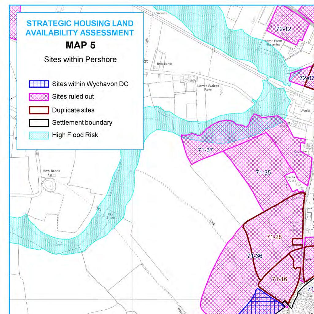
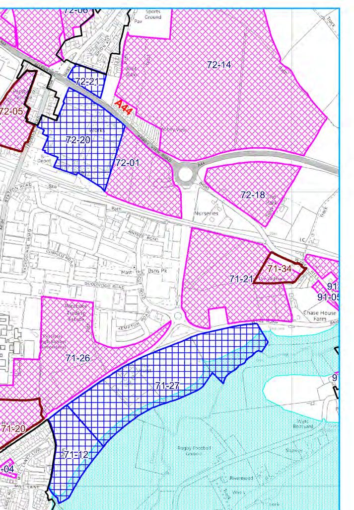
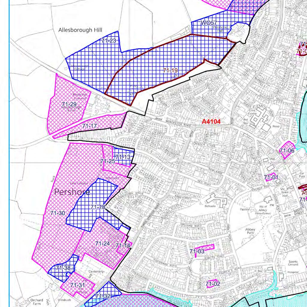
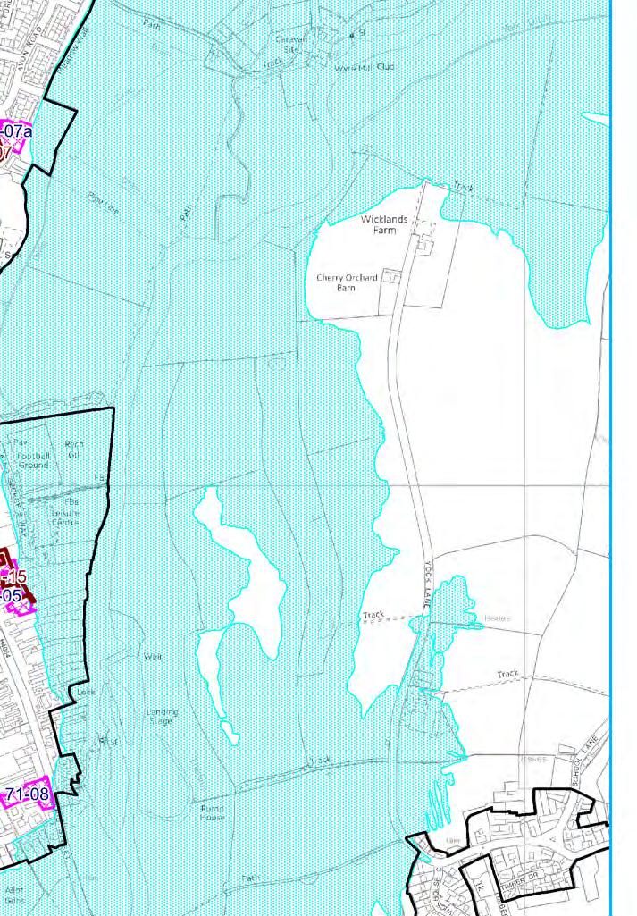
Summary of all SHLAA sites in Pershore
|
|
|
- Brent Baldwin
- 5 years ago
- Views:
Transcription

1
2 Summary of all SHLAA sites in Village Site area Site Ref Location Town/ (ha) Land adjacent to Abbey Springs Wychavon Health Centre, er Priest Lane Wychavon 0.17 ALLOCATED Garage Court, St Andrews Road, R/O Wychavon 0.19 ALLOCATED Garage Court, Abbots Road, R/O Wychavon 0.25 ALLOCATED Garage Court, Off Mill Lane Wychavon 0.18 PP Lane R/O Street, R/O 1-33 Wychavon 0.49 AVLBT UKOW Garage Main Street (Texaco) R/O Cherry Orchard Wychavon 0.47 ALLOCATED Cherry Orchard House, Cherry Orchard Wychavon 0.29 DUPLICATED 71-07a Cherry Orchard House & 44, 46, 48 & 50 Cherry Orchard Wychavon 0.61 PP Manor House Hotel, Bridge Street, Wychavon 0.28 FLOOD Garage Court, R/O Mayfield Road South/Apple Tree Road Wychavon 0.19 BUILT OUT Former Central Gardens, R/O Street, Head Street Wychavon 0.19 BUILT OUT Land adjacent to Hurst Road Cottages, Wyre Road Wychavon Land South of Holloway Wychavon 1.02 Land off Three Spring Lane, Adjacent o 62 Three Spring Road Wychavon 0.4 DUP/ AV UKOW Land R/O 31 & 33 Street Wychavon 0.29 DUPLICATED Land at the Croft, Off the B4082 Wychavon 3.62 DUPLICATED Land at Allesborough Hill, orth of Holloway Wychavon 2.07 PP Land off Three Springs Road & R/O Conningsby Drive Wychavon Land orth of Worcester Road Wychavon DUPLICATED Land orth of Wyre Road Wychavon 2.68 DUPLICATED Land East of Keytel 7 Business Park Wychavon 9.4 ELR Land South of Burlingham Close Wychavon FLOOD Land at Allesborough Hill Wychavon Land at 62 Three Springs Road, & adjoining land Wychavon 5.33 PP Land South of Holloway - Extend to include farm Wychavon AV UKOW Land orth of Wyre Road, South of Keytec 7 Business Park Wychavon 9.42 ELR Reason
3 71-27 Land South of Wyre Road Wychavon Land West of Station Road, orth of Junction with Wyre Piddle Wychavon 9.31 DUPLICATED Land west of Allesborough Farm, South of Worcester Road, Allesborough Hill Wychavon 4.98 AV UKOW Land South of Holloway, West of Three Springs Road/Defford Road Wychavon AV UKOW Land west of Defford Road Wychavon 1.68 PPG Land South of Junction of Defford Road/Three Springs Wychavon Land adjacent to Orchardene Wychavon 1.2 DUPLICATED Land adjacent to the Ford House (west of Station Road) Wychavon 9 LOCATIO Land off Station Road Wychavon DUP/ AV UKOW Land adjacent Station Road Wychavon FLOOD
4 Site Ref Location Garage Court, R/O Mayfield Road South/Apple Tree Road Site Ref Location Land adjacent to Hurst Road Cottages, Wyre Road Panel date 02/10/2007 Panel ame Evesham / Multiple Land Owners Attitude Panel date 02/10/2007 Panel ame Evesham / Unknown Greenfield (/) Greenfield (/) Assumed Dwelling Dwelling info Obligation Obligation constraint Appropriate Density (dws/ha) 0 Size of site Total potential Dwellings 0 Financial Viability for housing Availability constraint Appropriate Density (dws/ha) 40 Size of site 3.36 Total potential Dwellings 120 Financial Viability for housing Availability Within 5 years Remove. Part of site being developed so reduced size would be too small. 40dph less 10% for landscaping. BUILT OUT
5 Site Ref Location Land South of Holloway Site Ref Location Land at the Croft, Off the B4082 Panel date 02/10/2007 Panel ame Evesham / Panel date 02/10/2007 Panel ame Evesham / Unknown Land Owners Attitude Poor Greenfield (/) Greenfield (/) Obligation Junction at Three Springs Rd Obligation ew road, new junction required constraint orchard and woods on site es Appropriate Density (dws/ha) 30 Size of site 1.02 Total potential Dwellings 24 Financial Viability for housing Availability 5-10 years constraint Steep slopes - earthworks o Possible drainage and run off problems Appropriate Density (dws/ha) 40 Size of site 3.62 Total potential Dwellings 115 Financial Viability for housing Availability Within 5 years Access with Wadborough Rd difficult and junction with Three Springs Road difficult. Visual impact Currently wood and orchard, not a good site. Financial viability dependent on amount of earthworks required. All very visible from east.
6 Site Ref Location Land at Allesborough Hill, orth of Holloway Site Ref Location Land off Three Springs Road & R/O Conningsby Drive Panel date 02/10/2007 Panel ame Evesham / Unknown Land Owners Attitude Panel date 02/10/2007 Panel ame Evesham / Greenfield (/) Greenfield (/) Obligation way issues: road layout Obligation Traffic lights at Worcester Road and Three Springs constraint Appropriate Density (dws/ha) 30 Size of site 2.07 Total potential Dwellings 50 Financial Viability for housing Availability Within 5 years constraint Gently sloping Appropriate Density (dws/ha) 30 Size of site 0.99 Total potential Dwellings 30 Financial Viability for housing Availability Within 5 years Difficult shaped site - insufficient depth in some places this would reduce density. Hence 30 dph less 20% for landscape and layout issues.
7 Site Ref Location Land orth of Wyre Road Site Ref Location Land East of Keytel 7 Business Park Panel date 02/10/2007 Panel ame Evesham / Panel date 02/10/2007 Panel ame Evesham / Unknown Land Owners Attitude Greenfield (/) Greenfield (/) density Obligation Obligation constraint Footpath through site o Appropriate Density (dws/ha) 30 Size of site 2.68 Total potential Dwellings 80 Financial Viability for housing Availability Within 5 years constraint Appropriate Density (dws/ha) 25 Size of site 9.4 Total potential Dwellings 176 Financial Viability for housing Availability Within 5 years ot good site for residential - preferred for employment use, as too remote. ELR
8 Site Ref Location Land at Allesborough Hill Site Ref Location Land at 62 Three Springs Road, & adjoining land Panel date 02/10/2007 Panel ame Evesham / Unknown Land Owners Attitude Panel date 02/10/2007 Panel ame Evesham / Land Owners Attitude Greenfield (/) Greenfield (/) Obligation ew road would be required and new junction Obligation traffic lights at Worcester Road and Three Springs constraint Steep slopes earth works o possible drainage and run off issues Appropriate Density (dws/ha) 40 Size of site Total potential Dwellings 808 Financial Viability for housing Availability Within 5 years constraint Gently sloping Appropriate Density (dws/ha) 30 Size of site 5.21 Total potential Dwellings 140 Financial Viability for housing Availability Within 5 years All very visible from east. Would need new road and junction. Due to slope and visual impact 40dph less 25% for landscaping and infrastructure. 30 dph less 10%
9 Site Ref Location Land South of Holloway - Extend to include farm Site Ref Location Land orth of Wyre Road, South of Keytec 7 Business Park Panel date 02/10/2007 Panel ame Evesham / Land Owners Attitude 3 Panel date 02/10/2007 Panel ame Evesham / Multiple Greenfield (/) Greenfield (/) Obligation highway Obligation constraint Slope and access es drainage Appropriate Density (dws/ha) 30 Size of site 1.36 Total potential Dwellings 36 Financial Viability for housing Availability 5-10 years constraint Woodland o Appropriate Density (dws/ha) 30 Size of site 9.42 Total potential Dwellings 170 Financial Viability for housing Availability Unknown Depends on whether site in Three Springs Rd comes forward. 30 dph less 10% for landscaping. Concern over landscape impact - requires mitigating landscape. Site more suitable for employment. 30dph less 40% due to woodland and school playing field. ELR
10 Site Ref Location Land South of Wyre Road Site Ref Location Land West of Station Road, orth of Junction with Wyre Piddle Panel date 02/10/2007 Panel ame Evesham / Unknown Panel date 02/10/2007 Panel ame Evesham / Unknown Greenfield (/) Greenfield (/) Obligation Obligation constraint Appropriate Density (dws/ha) 40 Size of site 8.03 Total potential Dwellings 273 Financial Viability for housing Availability Within 5 years constraint o Appropriate Density (dws/ha) 40 Size of site 9.18 Total potential Dwellings 293 Financial Viability for housing Availability Within 5 years Illogical extension to. 40 dph less 20% for landscaping
11 Site Ref Location Land west of Allesborough Farm, South of Worcester Road, Allesborough Hill Site Ref Location Land South of Holloway, West of Three Springs Road/Defford Road Panel date 02/10/2007 Panel ame Evesham / Land Owners Attitude 3 Panel date 02/10/2007 Panel ame Evesham / Unknown Land Owners Attitude 3 Greenfield (/) Greenfield (/) Obligation Access issue on Lane Obligation constraint o Appropriate Density (dws/ha) 30 Size of site 4.98 Total potential Dwellings 135 Financial Viability for housing Availability Within 5 years constraint Slope and access issues drainage issues Appropriate Density (dws/ha) 30 Size of site Total potential Dwellings 448 Financial Viability for housing Availability 5-10 years Disconnected from settlement, too remote. Intrusive - listed buildings adjacent (x 2) Farm would be enclosed by development. 30 dph less 10% for landscape. 30 dph less 25% for landscape mitigation. visual impact - unlikely to be sympathetic backdrop to Abbey from Wick
12 Site Ref Location Land west of Defford Road Site Ref Location Land South of Junction of Defford Road/Three Springs Panel date 02/10/2007 Panel ame Evesham / Panel date 02/10/2007 Panel ame Evesham / Unknown Greenfield (/) Greenfield (/) low density Obligation Traffic lights at three Springs Rd/ Worcester Rd Obligation constraint Gently sloping Appropriate Density (dws/ha) 30 Size of site 1.68 Total potential Dwellings 45 Financial Viability for housing Availability Within 5 years constraint Established trees and hedges o Appropriate Density (dws/ha) 30 Size of site 1.22 Total potential Dwellings 33 Financial Viability for housing Availability Within 5 years Quite remote and removed from settlement. 30 dph less 10% landscape. Proposed extension to cemetery. Owned by town Council. Too rural, unsuitable for residential, beyond natural boundary. 30 dph less 10% for landscape PPG17
13 Site Ref Location Land adjacent to the Ford House (west of Station Road) Site Ref Location Land adjacent Station Road Panel date 20/10/2009 Panel ame Wychavon Panel date 02/11/2010 Panel ame Wychavon Poor Poor Greenfield (/) Greenfield (/) Assumed Dwelling Mixed Dwelling info one Obligation Obligation constraint es Appropriate Density (dws/ha) 30 Size of site 9 Total potential Dwellings 270 Financial Viability for housing Availability Available ow constraint Sloping, flooding issues with ford es Appropriate Density (dws/ha) 30 Size of site Total potential Dwellings 312 Financial Viability for housing Availability Within 5 years Fairly isolated site- would need to be considered as an extension to the Preferred Option site. Large part of site in floodplain, therefore could only realistically use eastern section of site and road frontage. Would be happy to see smaller section of site exclusing the floodplain resubmitted. LOCATIO FLOOD
14 Site Ref Location Land adjacent to Abbey Springs Panel date 18/04/2012 Panel ame Wychavon Poor Greenfield (/) one Obligation constraint Appropriate Density (dws/ha) 30 Size of site 1.23 Total potential Dwellings 36 Financial Viability for housing Availability Available ow site as extension to Bloor Homes/Bellway Homes site. Will need to demonstrate adequate access.
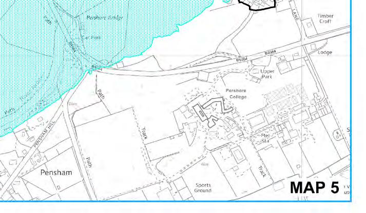
9 Pershore. Introduction. Pershore Abbey
 118 Introduction 9.1 The historic town of Pershore lies on the River Avon and has a population of 7,000 (2009 Mid-Term Population Estimates). The main areas of the town are centred on the Abbey, the bustling
Ashtead Neighbourhood Forum Site Assessment AS07 Old Chalk Pit, Pleasure Pit Road. Site ref: AS07 Site address: Old Chalk Pit, Pleasure Pit Road
 Site ref: AS07 Site address: Old Chalk Pit, Pleasure Pit Road Proposed Land Use: Total Site Area (Ha): Housing 0.7ha Description: The site was formally an old chalk pit that has been partially filled and
Evesham 7. Reasoned Justification
 95 Reasoned Justification 7.1 Evesham is situated within the Vale of Evesham and has an estimated population of 22,800 (2009 Mid-Term Population Estimates). As a main town it provides a wide range of services
Bradleys Both Parish Council
 Bradleys Both Parish Council Bradleys Both Housing Site Assessments April 2015 Contents 1.0 Introduction... 2 2.0 BR001 Health Lea and Land to Rear, Skipton Road... 2 3.0 BR002 Holly Tree House and Land
Test Valley Borough Council. Strategic Housing Land Availability Assessment (SHLAA)
") Test Valley Borough Council Strategic Land Assessment (SHLAA) Appendix 2 Southern Test Valley Sites Where a Change in Policy is Required for Residential Development Final Version as at 1 st April 2014
Test Valley Borough Council Strategic Land Assessment (SHLAA) Appendix 2 Southern Test Valley Sites Where a Change in Policy is Required for Residential Development Final Version as at 1 st April 2014
Site ref: AS06 Site Name or Address: Murreys Court, Agates Lane
 Site ref: AS06 Site Name or Address: Murreys Court, Agates Lane Proposed Land Use: Total Site Area (Ha): Housing 1.85 Ha Description: It is understood that the owner has no plans to dispose of the site
Story Homes. Land at Thirsk Road, Kirklevington. An Introduction to Story Homes. Our Foundations. Commitment to Consultation.
 Story Homes An Introduction to Story Homes Founded by Fred Story in 1987, Story Homes has a long and successful reputation of building high quality and high specification homes. The family owned business
Droitwich Spa 6. Reasoned Justification
 87 Droitwich Spa 6 Reasoned Justification 6.1 Droitwich Spa is identified in the settlement hierarchy (Policy SWDP1) as a main town being the largest settlement in Wychavon District with an estimated population
Public Consultation. Land at Monks Farm, North Grove. Welcome
 Welcome Welcome to our public exhibition for development on Land at Monks Farm, orth Grove. Gallagher Estates and Gleeson Strategic Land are preparing an outline planning application for new homes, open
Longhorsley Neighbourhood Plan
 Site Assessment 1. The availability of the site 1.1 Is the land owner willing for their site to be made available for development? 1.2 If yes, do you have any written evidence to back this up? Planning
Local Plan Committee
 Local Plan Committee 8 June 2015 Item 8 Report of Head of Commercial Services Author Chris Downes 01206 282476 Title Update on the new Local Plan Call for Sites process Wards affected All The Local Plan
Neighbourhood Planning Site Assessment Pro-forma and Guide Version 2
 Neighbourhood Planning Site Assessment Pro-forma and Guide Version 2 September 2014 Site HNP 006 Land East of Stanbridge Road and North of Lower Road 1. Background information Site location and use Site
OKEFORD FITZPAINE NEIGHBOURHOOD PLAN
 OKEFORD FITZPAINE NEIGHBOURHOOD PLAN Dear Parishioner, The Neighbourhood Plan Project Team have prepared this leaflet to summarise the full Neighbourhood Plan document. It provides a summary of the Vision,
Ashtead Neighbourhood Forum Site Assessment AS14 Land at The Pines, Farm Lane. Site ref: AS14 Site address: Land at The Pines, Farm Lane
 Site ref: AS14 Site address: Land at The Pines, Farm Lane Proposed Land Use: Total Site Area (Ha): Housing 2.1ha Description: The site is located to the east of Ashtead off Farm Lane and is currently grassed.
What do you like about South Marston?
 What do you like about South Marston? What you have said so far: Strong and separate identity, distinct from Swindon Village character (Church, School, Green and Hall) Surrounding working countryside and
Built Up Area Boundary (BUAB)
") Parish Boundary Built Up Area Boundary (BUAB) Potential Sites Map not to scale DWELLING SIZE POLICY Residential developments must provide a mix of dwelling sizes (market and affordable) that reflect the
Parish Boundary Built Up Area Boundary (BUAB) Potential Sites Map not to scale DWELLING SIZE POLICY Residential developments must provide a mix of dwelling sizes (market and affordable) that reflect the
Draft for Consultation Site Assessments and Opportunities
 Draft for Consultation Site Assessments and Opportunities Consultation period 29 th April 2016 to 20 th June 2016 29 th April 2016 Overview In assessing sites presented by Aylesbury Vale District Council
Ashtead Neighbourhood Forum Site Assessment AS03 Lime Tree Lodge, Farm Lane. Site address: Lime Tree Lodge, Farm Lane. Proposed Land Use:
 Site ref: AS03 Site address: Lime Tree Lodge, Farm Lane Proposed Land Use: Total Site Area (Ha): Housing 1.25ha Description The site is located off Farm Lane at the junction with Park Lane. To the north
Welcome. Land adjacent Sandy Lane WALTHAM CHASE THE PROPOSED SITE
 Land adjacent Sandy Lane WALTHAM CHASE Existing Linden Homes developments Welcome Welcome to Linden Homes Southern s ( Linden ) public exhibition about its proposals for a range of high-quality homes for
Site ref: AS05 Site address: Ashtead Park Garden Centre, Pleasure Pit Road
 Site ref: AS05 Site address: Ashtead Park Garden Centre, Pleasure Pit Road Proposed Land Use: Total Site Area (Ha): Housing 1.25ha Description: The site is located off Pleasure Pit Road near the junction
Plumpton Neighbourhood Plan Site Assessment Report
 Plumpton Neighbourhood Plan Site Assessment Report May 2016 1 Contents 1. Introduction 3 2. Methodology 4 2.1 Identification of Potential Sites 4 2.2 Assessment Process 5 2.3 Assessment Criteria 6 2.4
CAERNARFON DEPENDENCY CATCHMENT AREA
 CAERNARFON DEPENDENCY CATCHMENT AREA GWYNEDD UNITARY DEVELOPMENT PLAN - HOUSING Map not to scale Dependency Catchment Area Location 2 Caernarfon Topic Housing To the rear of Bro Eglwys, Bethel. Grid Ref.
SOUTH EAST LINCOLNSHIRE LOCAL PLAN: HOUSING PAPER DONINGTON (JUNE 2016)
") SOUTH EAST LINCOLNSHIRE LOCAL PLAN: HOUSING PAPER DONINGTON (JUNE 2016) 1 DONINGTON S PLACE IN THE SPATIAL STRATEGY 1.1 Policy 2 of the South East Lincolnshire Local Plan 2011-2036 Draft for Public Consultation
SOUTH EAST LINCOLNSHIRE LOCAL PLAN: HOUSING PAPER DONINGTON (JUNE 2016) 1 DONINGTON S PLACE IN THE SPATIAL STRATEGY 1.1 Policy 2 of the South East Lincolnshire Local Plan 2011-2036 Draft for Public Consultation
About 10% of the Borough's population lives in the seven rural parishes. Population figures from the 1991 census are given below:-
 8. THE DISTRICT VILLAGES 8.1 Population About 10% of the Borough's population lives in the seven rural parishes. Population figures from the 1991 census are given below:- Village No. of Persons Cottingham
HURSTPIERPOINT SAYERS COMMON PARISH COUNCIL
 HURSTPIERPOINT SAYERS COMMON PARISH OFFICE TRINITY ROAD HURSTPIERPOINT HASSOCKS WEST SUSSEX BN6 9UY TEL: 01273 833264 FAX: 01273 834976 E-MAIL: HURSTPIERPOINT.PC@BTINTERNET.COM WEB SITE: WWW.HURSTPIERPOINT-PC.ORG.UK
Welford-on-Avon Neighbourhood Plan Consultation Event Sunday, 6 April Your name Your address
 Welford-on-Avon Neighbourhood Plan Consultation Event Sunday, 6 April 2014 Your name Your email address Please either: - complete this feedback form and put it in the box before leaving the Memorial Hall
PHASE III: Reserved Matters Submission
 Statement of Compliance with the outline approval for the proposed residential development of land at: BURGES LANE, WIVELISCOMBE PHASE III: Reserved Matters Submission Foreword Contents: This Statement
Tarrington Neighbourhood Development Plan Housing site assessment
 Tarrington Neighbourhood Development Plan Housing site assessment December 2015 Dr DJ Nicholson DJN Planning Ltd 1. Introduction 1.1 Tarrington Neighbourhood Development Plan (NDP) Steering Group have
Proposed Modifications to Housing Allocations in South Worcestershire. Site Assessment Forms (Additional New Sites and Amended Sites Only)
") South Worcestershire Development Plan Proposed Modifications to Housing Allocations in South Worcestershire Site Assessment Forms (Additional ew Sites and Amended Sites Only) Wychavon District Council
South Worcestershire Development Plan Proposed Modifications to Housing Allocations in South Worcestershire Site Assessment Forms (Additional ew Sites and Amended Sites Only) Wychavon District Council
Core Strategy Settlement Classification. 0.61ha. For sale
 Coleford NDP site assessment 15 1 4 MARSHES LORDS HILL SITE ASSESSMENT FORM A: BASELINE INFORMATION Settlement Name Coleford Core Strategy Settlement Classification Town Site Name / Address Gross area
Report on Site Selection SR-0188 SR-0176 SR-0319 SR-0819 SR-0818 SR-0817 SR-0816 SR-0576 SR-0813 SR-0225 SR-0293 SR-0811 SR-0810 SR-0865
 EB81Gi SR-188 SR-176 SR-319 SR-819 SR-818 SR-817 SR-576 SR-816 SR-225 SR-813 SR-293 SR-81 SR-811 SR-865 Report on Site Selection. EFDC-S2-1-Rev1 Date: September 216 Scale: 1:12,5 @A3 Content Source: Esri,
8.0 Design and Form of Development 43/
 42/ 8.0 Design and Form of Development 43/ Rothwells Farm, Golborne/ Development Statement Figure 7. Site Constraints Key 44/ Site Boundary 360 Bus Route/Stops Existing Trees Underground Water Pipe Sensitive
INTRODUCTION CURRENT APPLICATION
 05/01805/FUL & 05/01807/LBC ERECTION OF A SINGLE DWELLING HOUSE WITH ANCILLARY ACCOMMODATION AT Flamingo Zoological Gardens, Olney Road, Weston Underwood FOR Mr A J Crowther (as amended by letter dated
Carterton Construction Ltd is bringing forward plans for up to 85 new family homes and extra care facilities on land east of Burford.
 Welcome Carterton Construction Ltd is bringing forward plans for up to 85 new family homes and extra care facilities on land east of. We are at the early stages of designing our proposals and have a number
WELCOME. Welcome and thank you for visiting today.
 WELCOME Welcome and thank you for visiting today. Bellway Homes Ltd (Yorkshire) are preparing a reserved matters planning application for a residential development of 293 homes at land North of Yew Tree
Appendix I: Addendum to Development Frameworks Evidence Paper
 Appendix I: Addendum to Development Frameworks Evidence Paper Ref. o. Table 3 Suggested village frameworks amendments from Proposed Submission with Council's assessment Key shaded rows indicate suggested
Welcome to our public exhibition
 About Our Scheme Welcome to our public exhibition This exhibition gives you the chance to view and comment upon our emerging proposals for a new residential development of 68 new homes on the site of the
Neighbourhood Plan Representation
 Date: 10 th November 2017 Neighbourhood Plan Representation Land to the east of Callow Hill Road, Alvechurch Introduction This representation has been prepared by RPS Planning and Development on behalf
an Inspector appointed by the Secretary of State for Communities and Local Government
 Appeal Decision Site visit made on 14 July 2015 by I Radcliffe BSc(Hons) MCIEH DMS an Inspector appointed by the Secretary of State for Communities and Local Government Decision date: 18 August 2015 Appeal
Wallingford Neighbourhood Plan
 Wallingford Neighbourhood Plan Introduction What is neighbourhood planning? Neighbourhood planning was introduced by the Localism Act 2011 to give local people more influence over how development comes
Land off Arbour Close and Cotswold Edge Mickleton, Gloucestershire. Design and Access Statement Mickleton, Gloucestershire
 Land off Arbour Close and Cotswold Edge Contents INTRODUCTION Vision SITE DESCRIPTION The site Technical Assessment ASSESSMENT & EVALUATION Constraints and opportunities SITE CONTEXT Pattern of Development
SITE ASSESSMENT CHECKLIST
 1. Site Details a. What is the site s name/reference? SITE ASSESSMENT CHECKLIST CR3NPWHY 3007 Gasometer Site Godstone Road CR3 0EG b. Where is the site located? Wyhteleafe; Godstone Road. Urban category1
Plumpton Neighbourhood Development Plan Revised Pre Submission Document - Regulation 14 Consultation
 REPRESENTATIONS... Plumpton Parish Council Plumpton Neighbourhood Development Plan Revised Pre Submission Document - Regulation 14 Consultation Representations submitted on behalf of: Cala Homes (South
WEST DORSET, WEYMOUTH AND PORTLAND STRATEGIC HOUSING LAND AVAILABILITY ASSESSMENT
 WEST DORSET, WEYMOUTH AND PORTLAND STRATEGIC HOUSING LAND AVAILABILITY ASSESSMENT ADDENDUM DECEMBER 2016 Contents 1. Introduction & Aims... 3 1.1 The role of a Strategic Housing Land Availability Assessment...
Briefing Document of CNP. June 2017
 Cholsey Parish Council Cholsey Neighbourhood Plan Briefing Document of CNP June 2017 Cholsey Neighbourhood Plan Page! 1 of! 8 Cholsey Plan Briefing v1.4 Page Left Intentionally Blank Cholsey Neighbourhood
WELCOME LAND EAST OF TYE LANE, WALBERTON. Above all, it s about people
 WELCOME Welcome to this public exhibition relating to our draft residential proposals for the land east of Tye Lane, Walberton. Today gives you the opportunity to have an active role in shaping these ideas
PDP DESIGN & ACCESS STATEMENT
 PDP The Planning & Design Partnership Planning.. Architecture.. Interiors.. Landscape The Chicory Barn Studio, The Old Brickyards, Moor Lane, Stamford Bridge York, The East Riding Of Yorkshire, YO41 1HU.
Application Recommended for Approval Hapton with Park Ward
 Application Recommended for Approval Hapton with Park Ward APP/2017/0036 Outline Planning Application Outline application for the construction of a new 3 bedroom dwelling (with all matters reserved for
New House Farm, Risbury, Nr Leominster, Herefordshire
 New House Farm, Risbury, Nr Leominster, Herefordshire A beautiful farmhouse and numerous extremely versatile outbuildings, in extensive gardens and paddocks with superb views. 7 Acres LOCATION Leominster
Introduction. Welcome to this consultation regarding the draft redevelopment proposals for the former CeramTec factory on Sidmouth Road, Colyton.
 Introduction Welcome to this consultation regarding the draft redevelopment proposals for the former CeramTec factory on Sidmouth Road, Colyton. We are currently considering options for the mixed-use redevelopment
Joint Core Strategy Rushden Sustainable Urban Extension
 Date Page 1 of 18 Report Originator Title Planning Manager Joint Core Strategy Rushden Sustainable Urban Extension 1. PURPOSE OF REPORT 1.1 To consider representations received on the emerging Joint Core
Welcome to our Public Consultation
 About our development This exhibition gives you the chance to view and comment on our emerging plans for a proposed residential development located on land to the West of Alwyn Road, Rugby. Welcome to
an Inspector appointed by the Secretary of State for Communities and Local Government
 Appeal Decision Site visit made on 6 November 2017 by Rachel Walmsley BSc MSc MA MRTPI an Inspector appointed by the Secretary of State for Communities and Local Government Decision date: 19 th January
EXHIBIT 5-1 VILLAGE OF WILD ROSE FUNCTIONAL CLASS AND AVERAGE DAILY TRAFFIC VOLUMES 2000 & 2003 DATA
 3400 3600 EXHIBIT 5-1 FUNCTIONAL CLASS AND AVERAGE DAILY TRAFFIC VOLUMES 2000 & 2003 DATA Rural Minor Arterial Rural Major Collector Rural Minor Collector Rural Local 2000 Traffic Count 2003 Traffic Count
Statement of Community Involvement LAND OFF SOUTHDOWN ROAD HORNDEAN, HAMPSHIRE
 LAND OFF SOUTHDOWN ROAD HORNDEAN, HAMPSHIRE CONTENTS Page 1. Introduction 3 2. Pre-application Discussions 4 3. The Consultation Process 5 4. Consultation Feedback 7 5. Responses to Consultation Feedback
Welcome to our exhibition
 Welcome to our exhibition The Homes & Communities Agency (HCA) welcomes you to this public exhibition explaining our proposals for the redevelopment of the former Lea Castle Hospital site. About the Homes
1. Local Plan Context
 1. Local Plan Context WHY ARE YOU HERE? ABOUT US PLANNING APPLICATION CONSULTATION Stewart Milne Homes are in the process of preparing a detailed planning application for a development of approximately
SITE ASSESSMENTS. September 2018 SOUTHWATER PARISH COUNCIL BEESON HOUSE, 26 LINTOT SQUARE, SOUTHWATER, RH13 9LA
 September 2018 SITE ASSESSMENTS PREPARED TO ASSIST THE PREPERATION OF THE SOUTHWATER NEIGHBOURHOOD PLAN SOUTHWATER PARISH COUNCIL BEESON HOUSE, 26 LINTOT SQUARE, SOUTHWATER, RH13 9LA INTRODUCTION TABLE
Cranbrook EXPANSION ENVIRONMENTAL STATEMENT: NON-TECHNICAL SUMMARY PRODUCED BY DAVID LOCK ASSOCIATES
 Cranbrook EXPANSION ENVIRONMENTAL STATEMENT: NON-TECHNICAL SUMMARY PRODUCED BY DECEMBER 2014 CRANBROOK EXPANSION AREAS ENVIRONMENTAL STATEMENT NON TECHNICAL SUMMARY Submitted in support of Outline Planning
Character Area Summary 6: Canal Zone Stonehouse Town Character Assessment, Bridgend Works from Downton Road
 Character Area Summary 6: Canal Zone An open area, with residential and industrial areas, which has a rural character and a rich historic and natural environment strongly influenced by the Stroudwater
DHT 750_EDR_00 Ecological Deliverability Appraisal DHT Access Appraisal C DHT Heritage Overview
 Consultee ID:1020173 April 2017 Rep Summary TTV29 (7) Broom Park Field Legal, Compliant and Sound Hearing: DHT wish to participate in the examination hearings to further develop our comments, to enable
Mortimer NDP, Principles, Vision and Policies
 The Three Principles Mortimer NDP, Principles, Vision and Policies 1. The NDP must make it possible for people to live the whole of their lives in the parish if they so wish 2. 2. The NDP will ensure that
Table of Allocated Housing Sites
 Draft as of 0 November 016 Table of Allocated Housing s Name Green 1 (30, 33, 10, 169, 36/ 100) Barratt s Farm Balsall Common Yes 57 800 Includes existing park. Listed buildings to edge of site. of search
Little Hadham Neighbourhood Plan
 Little Hadham Neighbourhood Plan Site Assessment Little Hadham Parish Council vember 2017 Final This page is intentionally blank. Quality information Project Role Name Position Actions Summary Signature
BLETCHLEY PARK AREA - DEVELOPMENT FRAMEWORK
 ANNEX A To Item 9 REVISED TEXT: additions shown bold and underlined, deletions in (brackets and in italics). BLETCHLEY PARK AREA - DEVELOPMENT FRAMEWORK This framework sets out the key objectives and requirements
Great Easton Sustainable Housing Development Sites - Site Seven, Broadgate extension site SHLAA Ref HSG/03)
") Great Easton Sustainable Housing Development Sites - Site Seven, Broadgate extension site SHLAA Ref HSG/03) 1. Introduction The Great Easton Neighbourhood Plan Group are preparing a Neighbourhood Plan
Great Easton Sustainable Housing Development Sites - Site Seven, Broadgate extension site SHLAA Ref HSG/03) 1. Introduction The Great Easton Neighbourhood Plan Group are preparing a Neighbourhood Plan
Hodgson s Gate. Welcome. Who we are. Hodgson s Gate Developments. Thank you for taking time to attend today s event.
 Welcome Thank you for taking time to attend today s event. is promoting land off Hodgson s Lane at, Sherburn-in-Elmet for a sustainable and high quality development. We are currently preparing an application
Rochford District Council Allocations Development Plan Document: Discussion and Consultation Document Sustainability Appraisal
 Option SWH1 Balanced Communities Option SWH1 1 To ensure the delivery of high quality sustainable communities where people want to live and work Will it ensure the phasing of infrastructure, including
Blandford Forum Town Council, Blandford St Mary Parish Council and Bryanston Parish Council
 Blandford Forum Town Council, Blandford St Mary Parish Council and Bryanston Parish Council Blandford + Neighbourhood Plan 2 Pre-Submission Plan Consultation (November 2018) Representations submitted on
Land East of Cromwell Lane
 Land East of Cromwell Lane VISION DOCUMENT AUGUST 2016 The proposals for Land East of Cromwell Lane will be defined by existing landscape features, ensuring that the development offers a quality place
There are two assessment methods used. The first is according to the criteria set out in the Neighbourhood Plan which are set out below.
 Background Paper 4 Site Assessments Context This background paper has been compiled to support the Gotham Neighbourhood Plan and is intended to document the viability of sites around Gotham with respect
Dunsfold Neighbourhood Plan. Site Assessment Report
 Dunsfold Neighbourhood Plan Site Report vember 2018 Quality information Prepared by Checked by Approved by Lachlan Anderson-Frank Planner Una McGaughrin Associate Una McGaughrin Associate Revision History
Dartington. Webbers Yard, Higher Tweed Mill and Sawmills Field. Masterplan and Development Brief. Revision E. September 2012.
 Webbers Yard, Higher Tweed Mill and Sawmills Field Dartington Masterplan and Development Brief Revision E. September 2012. Prepared by LHC on behalf of The Dartington Hall Trust & Cavanna Homes 2 Webbers
Alder View. Introduction. Alder View. Harwell. The Vision. The Team. Taylor Wimpey
 Introduction Welcome to the public exhibition for, a development by Taylor Wimpey on the land south of Grove Road,. This exhibition will provide an overview of the development proposals for the site and
Development of land adjacent to Braggs Farm Lane and Rumbush Lane, Dickens Heath. Welcome. Today s exhibition. The proposal site
 Welcome Welcome to this event to discuss the development of land adjacent to Braggs Farm Lane. is currently in the preliminary stages of designing proposals to sensitively develop this site with high-quality
PROPOSAL FOR NEW HOMES ON LAND OFF WALTON ROAD
 PROPOSAL FOR NEW HOMES ON LAND OFF WALTON ROAD The Homes and Communities Agency are developing proposals to deliver new homes on surplus public sector land off Walton Road. The thoughts of the local community
Site ref: AS11 Site Name or Address: Land South of Ermyn Way
 Site ref: AS11 Site Name or Address: Land South of Ermyn Way Proposed Land Use: Total Site Area (Ha): Residential 11.4 Ha Description: The site comprises an area to the south of Green Lane and Ermyn Way,
A Response Objecting to Outline Planning Application by Hallam Land Ltd.
 1 A Response Objecting to Outline Planning Application by Hallam Land Ltd. Off Abbey Road, Evesham Ref 16/02814 Response Prepared by The Vale of Evesham Civic Society CT amendments in red Date - 16 th
Cookham Parish Council s Response to The Draft Local Borough Plan
 Cookham Parish Council s Response to The Draft Local Borough Plan As Agreed at the Planning Committee Meeting on 10 th January 2017. Designation of Poundfield as a Local Green Space The Parish Council
Doncaster Employment Land Review Site Assessment. UDP Policy: Employment Policy Area
 70. 3 Horse Shoes xisting mployment UDP Policy: mployment Policy Adj Bentley North Bridge Roundabout xisting or Proposed: 3a B 8.83 59 Worse than average B2 0.00 44 Average B8 8.62 58 Worse than average
SITE ASSESSMENT CHECKLIST
 1. Site Details a. What is the site s name/reference? CR3 FORUM NEIGHBOURHOOD PLAN SITE ASSESSMENT CHECKLIST CR3NPCOH3016 Douglas Brunton Centre Park Rd b. Where is the site located? Caterham Hill urban
Wiltshire Council s Core Strategy
 HAWKE Wiltshire Council s Core Strategy 2006-2026 As part of its Core Strategy (master plan), Wiltshire Council needs to find areas to develop for employment purposes up to 2026. This land was first suggested
Form to Submit Land for Residential Evidence Gathering Shepway Strategic Housing Land Availability Assessment (SHLAA) Partial Review
 Partial Review") Form to Submit Land for Residential Evidence Gathering Shepway Strategic Housing Land Availability Assessment (SHLAA) Partial Review All organisations and individuals who wish to put forward land for consideration
Form to Submit Land for Residential Evidence Gathering Shepway Strategic Housing Land Availability Assessment (SHLAA) Partial Review All organisations and individuals who wish to put forward land for consideration
DUNSFOLD NEIGHBOURHOOD PLAN Site Selection Policies
 DUNSFOLD NEIGHBOURHOOD PLAN Site Selection Policies The criteria for assessing sites for future housing and business development in Dunsfold are set out below. (Development criteria, covering what it is
Replacement Golf Course Facilities and Residential Development, Churston. Environmental Statement Non-Technical Summary
 Replacement Golf Course Facilities and Residential Development, Churston Environmental Statement Non-Technical Summary July 2011 Reproduced from the Ordnance Survey s map with the permission of the Controller
GUILDFORD BOROUGH GREEN BELT AND COUNTRYSIDE STUDY
 GUILDFORD BOROUGH GREEN BELT AND COUNTRYSIDE STUDY Volume II - Addendum On behalf of Guildford Borough Council PPG Ref : BNL.0287 April 2014 COPYRIGHT The conents of this document must not be copied or
Hampton Park North Littlehampton West Sussex
 North Littlehampton West Sussex SUMMARY Summary An opportunity to create a new community in West Sussex on the northern outskirts of Littlehampton with outstanding views across open countryside towards
East Harptree Site EH3 Parker s Mead, Church Lane
 East Harptree Site EH3 Parker s Mead, Church Lane Photograph EH3.1 View looking north towards Chew Valley Lake Photograph EH3.2 Church Lane, adjacent to western site boundary Reference Baseline Information
Shenley Neighbourhood Development Plan Pre-Submission Plan, Regulation 14 Consultation
 Amanda Leboff, Clerk Shenley Parish Council Shenley Neighbourhood Plan c/o Shenley Parish Council The Hub London Road Shenley Herts WD7 9BS Sent by email to: clerk@shenleyvillage.org Hertfordshire County
Exhibit A Comprehensive Plan Amendments
 Exhibit A Comprehensive Plan Amendments May 2010 Draft Chapter One - Introduction Chapter One INTRODUCTION NOTE: For brevity and ease in viewing the proposed changes, portions of chapter one that are not
ASSESSMENT OF LOCAL GAPS IN BREDON PARISH
 ASSESSMENT OF LOCAL GAPS IN BREDON PARISH Revised May 2016 1. Introduction 1.1 Bredon Parish Council has set out to identify s along the connecting roads between settlements in the parish, which either
MAYFIELD WEST SECONDARY PLAN PHASE 2
 MAYFIELD WEST SECONDARY PLAN PHASE 2 Council Information Workshop February 16, 2010 Draft Preferred Land Use Plan TOWN OF CALEDON PLANNING & DEVELOPMENT DEPARTMENT Workshop Agenda TOWN OF CALEDON 1. Welcome
Chichester District Council. Planning Committee 3 February Masterplan for the Westhampnett/NE Chichester Strategic Development Location (SDL)
") Chichester District Council Planning Committee 3 February 2016 1. Contacts Masterplan for the Westhampnett/NE Chichester Strategic Development Location (SDL) Report Author: Jo Bell, Development Manager
Chichester District Council Planning Committee 3 February 2016 1. Contacts Masterplan for the Westhampnett/NE Chichester Strategic Development Location (SDL) Report Author: Jo Bell, Development Manager
University Park, Worcester Non Technical Summary December 2011
 University Park, Worcester Non Technical Summary December 2011 Introduction UW Wrenbridge LLP, a Joint Venture Company of the University of Worcester and Wrenbridge Land Ltd (the Applicants ) intend to
Application and Proposals. Part 211
 Application and Proposals Part 211 Site Location and Context The application site comprises two distinct land parcels totalling some 135 hectares. The site is bisected eastwest by Churchlands Development.
Warwickshire County Council. Upper and Lower Brailes. Landscape Study
 Warwickshire County Council Upper and Lower Brailes Landscape Study Produced by WCC Landscape Architects March 2016 Landscape Assessment of Potential Development Sites within the parish of Brailes 1.0
INTRODUCTION. Land south of Bishopswood Lane, Tadley
 0 INTRODUCTION THE SITE Introduction Gladman Developments Ltd. has successfully invested in communities throughout the UK over the past 0 years, developing high quality and sustainable residential, commercial
Environmental and Landscape Mapping
 Environmental and Landscape Mapping In support of the Calveley Neighbourhood Plan November 2016 Project Name and Number: Calveley Neighbourhood Plan 16-025 Document Name and Revision: Environmental and
APP/G1630/W/15/
 Appeal Decision Site visit made on 20 October 2015 by William Fieldhouse BA (Hons) MA MRTPI an Inspector appointed by the Secretary of State for Communities and Local Government Decision date: 20 November
Settlement Boundaries Methodology North Northumberland Coast Neighbourhood Plan (August 2016)
") Introduction This background paper sets out a methodology for the definition of settlement boundaries in the North Northumberland Coast Neighbourhood Plan. The neighbourhood plan is planning positively
Introduction This background paper sets out a methodology for the definition of settlement boundaries in the North Northumberland Coast Neighbourhood Plan. The neighbourhood plan is planning positively