treet Alley 23rd Street FOR SALE 2419 and Street, PRIME CENTRAL CORE OPPORTUNITY Sacramento, CA 95815
|
|
|
- Dominick Pearson
- 5 years ago
- Views:
Transcription


1 FOR SALE 2419 and Street, Street McCulley Brothers Complete Automotive Repair Google rdmaps plete Automotive Repair PRIME CENTRAL CORE OPPORTUNITY X Street Broadway S treet ing nald s pa rk McDo 23 rd Alley 23rd Street All ey PROPERTY McDonald s pa rking Broadwa y Street Stre e t Imagery 2017 Google, Map data 2017 Google 20 ft
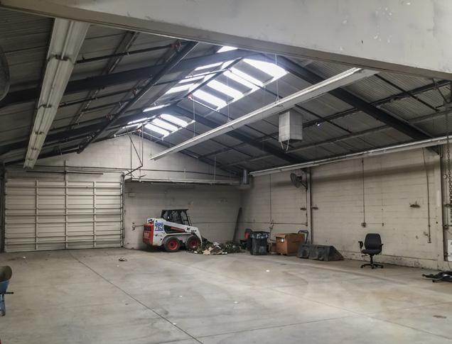
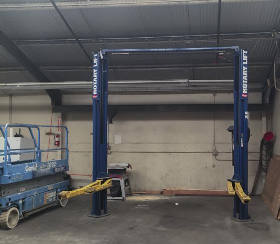
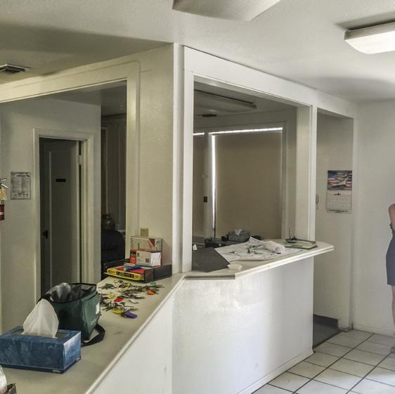
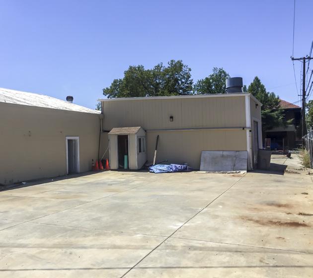
2 FOR SALE 2419 and rd Street PROPERTY HIGHLIGHTS Property Description The Subject Property is located adjacent to what is known as The Broadway Corridor, home to a variety of businesses, residents, government facilities, industrial centers, and cultural hot spots in the City of Sacramento. Formerly known as Y Street, Broadway has a rich history and contemporary street vibe that must be preserved and enhanced. The corridor is comprised of three distinct districts: the Marina District, the Tower District, and the Upper District. While each of these districts has all of the basic amenities to serve the existing land uses, the corridor lacks the facilities necessary to take full advantage of its potential to become a vibrant mixed-use multi-modal destination. The subject property is approximately.28 acres in land size (12,493 SF) and consists of 2 parcels with approximately 6,160 SF of building, 1,560 SF of covered shed roof area along with a concrete paved, fenced parking/yard area if approximately. This property location offers a prime development opportunity for a mixed use commercial-residential development. The Property offers an excelent opportunity for a brew pub, restaurant, art gallery, or other public gathering space. The Property is ideally located just off Business Interstate 50 and 80 and also has easy access to Interstate 99. The property is located in close proximity to major employers like Department of Motor Vehicles and Sutter General Hospital. APN SF (Assessor) Acre (Assessor) SF (Calculated) Acre (Calculated) Parcel # , , Zoning Current Use Parcel # , , C-2 comm Total 12, , Zoning: C-2 Commercial The purpose of the C-2 zone is to provide for the sale of goods; the performance of services, including repair facilities; office uses; dwellings; small wholesale stores or distributors; and limited processing and packaging. This is a general commercial zone which provides for the sale of commodities, or performance of services, including repair facilities, offices, small wholesale stores or distributors. Good examples are a small neighborhood hardware store or a corner market or restaurants, retail outlets, coffee shops, brewpubs, cannabis, and art gallerys. Height allowances: the maximum height is 65 feet, however there is a transitional height restrictions if the C-2 zone is within certain distances of the R-1, R-1B, and R-2 zones. There is no lot coverage requirement. Minimum and maximum floor area ratios are established in the general plan and should be referenced in. Ord and Ord Demographic Overview Local market area: neighborhoods of Land Park, Curtis Park, Southside Park, Richmond Grove, Newton Booth and portions of Oak Park (census tracts) 12,700 households, about 26,500 population (2010), diverse Higher household income than the City, diverse income distribution.


3 FOR SALE 2419 and rd Street 95815

4 FOR SALE 2419 and rd Street The Broadway Corridor Last year developers poured foundations for the first of what will be 1,000 And restaurateur Randall Selland just opened his upscale restaurant, The Kitchen, town homes, bungalows and lofts on a 32-acre former lumber mill site near the from the suburbs to an old supermarket site across Broadway from the old city intersection of Interstate 5 and interstate The project, called The Mill at cemetery a move cheered up and down the corridor. It was location, location, Broadway, is billed as a future home for young adults who want to walk to work location, Selland said. Honestly, we have been looking downtown to move The downtown, and for baby boomers who might trade bigger Land Park houses Kitchen for a couple of years, and really it s the perfect location for what The and yards for a lock-and-leave lifestyle. Sales to date have been very successful Kitchen is and what people want from it. 6/6/2017 more phases are under construction rd rd St Google Maps St A few blocks east, redevelopment officials and private developers plan to tear down the World War II-era housing projects known as Marina Vista and Alder Grove, and replace them with a denser, mixed-income community. The pub- The idea, proponents say, is to transform what has become a dangerous, highspeed commuter cut-through into a tree-lined, small-town street where people can ride bikes and restaurants are willing to put tables out for sidewalk seating. lic-private group is expected to brief the City Council on its plan later this month. et e r rd St 3 2

5 FOR SALE 2419 and rd Street Parcel Map Aerial Close Up Alley PROPERTY 23 rd Street McDonald s parking Broadway Street.
6 FOR SALE 2419 and rd Street The Broadway Corridor The goal of the Corridor Streets effort is to identify the changes necessary to make this historic Corridor a more inviting and safe place for all users. In 2012, the Urban Land Institute s Sacramento District Council (ULI), in cooperation with the Greater Broadway Partnership, developed a Vision Plan for the Broadway Corridor. The Vision Plan included a variety of recommendations for the Broadway Corridor from pedestrian enhancements, suggestions for mixed-use infill development, and aesthetic guidelines for each District and the Broadway Corridor as a whole. ULI envisioned Broadway not only as a Complete Street, but also as a premier pedestrian street. The City of Sacramento, in collaboration with the Greater Broadway Partnership, Sacramento Area Council of Governments (SACOG), Sacramento Regional Transit (RT), the California Department of Transportation (Caltrans), and the community, is working to refine the work completed by ULI into a Complete Streets Plan in order to bridge the gap between vision and implementation. The result of this effort will be a detailed plan of specific improvements intended to balance all modes of travel and enhance the Broadway Corridor as a destination to live, work, and play. The goals of the Broadway Complete Streets Plan include: Balance accessibility for all modes of transportation in the Broadway Corridor Enhance safety and comfort for all modes, especially pedestrians and bicyclists Encourage economic revitalization and reinvestment along the Corridor Currently, the Broadway Corridor is an automobile-dominated arterial with sidewalks of varying widths, complicated pedestrian crossings, and discontinuous bike lanes creating a less than optimal environment for anyone attempting to travel without a car.
LAND PARK COMMUNITY PLAN
 LAND PARK Community Plan Part Three : COMMUNITY PLAN AREAS AND SPECIAL STUDY AREAS SACRAMENTO 2030 GENERAL PLAN Contents Community Location...3-LP-3 Community Vision...3-LP-4 Community Profile...3-LP-4
1.0 VISION STATEMENT. December 6, PRINCIPLES
 Vision Statement Lincoln Regional Airport 1.0 VISION STATEMENT 1.1 City LOCATION of AND OVERVIEW The Easton Lincoln Place Land Use Master Plan identifies the principles, goals, policies, and standards
Chapter 1: Introduction
 Chapter 1: Introduction The Penn Avenue Community Works Corridor Vision and Implementation Framework presents an integrated communitybased vision and a coordinated, long-term implementation framework for
Ivywild On The Creek PRELIMINARY CREEK DISTRICT MASTER PLAN
 Ivywild On The Creek PRELIMINARY CREEK DISTRICT MASTER PLAN Introduction: Rejuvenating an extraordinary Creekside neighborhood THE CREEKSIDE DISTRICT The Ivywild On The Creek Neighborhood District Master
Wasatch CHOICE for 2040
 Wasatch CHOICE for 2040 Economic Opportunities We Can Choose a Better Future We enjoy an unparalleled quality of life along the Wasatch Front. People from all over the world are drawn to our stunning scenery,
ELK GROVE GENERAL PLAN VISION
 2-1 CHAPTER 2: 2-2 CREATING OUR The Community Vision for Elk Grove, expressed through a Vision Statement and a series of Supporting Principles, is a declaration of the kind of community that Elk Grove
Draft for Public Review. The Market and Octavia Neighborhood Plan
 Draft for Public Review The Market and Octavia Neighborhood Plan San Francisco Planning Department As Part of the Better Neighborhoods Program December 2002 IOverview Why Plan a Better Neighborhood Here
REQUEST FOR PROPOSALS (RFP) DEVELOPMENT OF CITY-OWNED PROPERTY LOCATED AT THE NORTHWEST CORNER OF OLIVE BOULEVARD AND MIDLAND BOULVARD
 DEVELOPMENT OF CITY-OWNED PROPERTY LOCATED AT THE NORTHWEST CORNER OF OLIVE BOULEVARD AND MIDLAND BOULVARD") REQUEST FOR PROPOSALS (RFP) DEVELOPMENT OF CITY-OWNED PROPERTY LOCATED AT THE NORTHWEST CORNER OF OLIVE BOULEVARD AND MIDLAND BOULVARD CITY OF UNIVERSITY CITY 6801 DELMAR BOULEVARD UNIVERSITY CITY, MO
REQUEST FOR PROPOSALS (RFP) DEVELOPMENT OF CITY-OWNED PROPERTY LOCATED AT THE NORTHWEST CORNER OF OLIVE BOULEVARD AND MIDLAND BOULVARD CITY OF UNIVERSITY CITY 6801 DELMAR BOULEVARD UNIVERSITY CITY, MO
Policies and Code Intent Sections Related to Town Center
 Policies and Code Intent Sections Related to Town Center The Town Center Vision is scattered throughout the Comprehensive Plan, development code and the 1994 Town Center Plan. What follows are sections
Lehigh Acres Land Development Regulations Community Planning Project
 Lehigh Acres Land Development Regulations Planning Effort Summary In July, 2010 Commissioner Frank Mann invited the Lehigh Acres community to start discussing how to achieve their recently adopted community
DOWNTOWN RESIDENTIAL DISTRICT DEVELOPMENT OPPORTUNITES
 DOWNTOWN RESIDENTIAL DISTRICT DEVELOPMENT OPPORTUNITES Out of all the areas in Downtown Painesville, this district provides the greatest opportunity for change with the vacation of Lake East Hospital.
EXISTING COMPREHENSIVE PLAN
 EXISTING COMPREHENSIVE PLAN Town Center Land Use Element: V. LAND USE POLICIES Town Center Mercer Island's business district vision as described in "Your Mercer Island Citizen-Designed Downtown" was an
MALL REVITALIZATION CASE STUDIES
 MALL REVITALIZATION CASE STUDIES DECEMBER 9, 2012 MALL REVITALIZATION OVERVIEW Introduction Sample Case Studies prepared for Lacey Woodland District Steering Committee as it considers strategies to revitalize
Subregion 4 Central Avenue-Metro Blue Line Corridor Transit-Oriented Development (TOD) Implementation Project. Community Meeting April 27, 2011
 Implementation Project. Community Meeting April 27, 2011") Subregion 4 Central Avenue-Metro Blue Line Corridor Transit-Oriented Development (TOD) Implementation Project Community Meeting April 27, 2011 Overview Introduction to Subregion 4 TOD Implementation Program
Subregion 4 Central Avenue-Metro Blue Line Corridor Transit-Oriented Development (TOD) Implementation Project Community Meeting April 27, 2011 Overview Introduction to Subregion 4 TOD Implementation Program
Glenborough at Easton Land Use Master Plan
 Vision Statement Sunrise Blvd. Hazel Ave. Prairie City Rd. Gencorp Property Lincoln Regional Airport 1.0 VISION STATEMENT The identifies City of the principles, goals, policies, and standards Lincoln that
Unique. Livable. Connected. Sustainable. Anticipate and Manage Change. Variety of Housing Choices. Enhanced Arterial Corridors
 Neighborhood Vision The Old Town Neighborhoods are Unique, Livable, Connected, and Sustainable. As mature, established neighborhoods, many of the ideas and opportunities expressed by stakeholders in support
CHAPTER 3 VISION, GOALS, & PLANNING PRINCIPLES. City of Greensburg Comprehensive Plan. Introduction. Vision Statement. Growth Management Goals.
 CHAPTER 3 VISION, GOALS, & PLANNING PRINCIPLES Introduction The Greensburg Comprehensive Plan is intended as a working community document. A combination of long and short-term goals, this document is intended
Sahuarita District & Phase 1 Master Plan. Town Council December 11, 2017
 Sahuarita District & Phase 1 Master Plan Town Council December 11, 2017 Visioning Study Visioning Process Advisory Group Meetings Community Questionnaire Town Center Case Studies Community Analysis The
Chapter 4. Linking Land Use with Transportation. Chapter 4
 Chapter 4 Linking Land Use with Transportation Chapter 4 59 Chapter 4 Linking Land Use with Transportation Community Design and Transportation Program Introduction Since the 1950s, the predominant development
Complete Neighbourhood Guidelines Review Tool
 Complete Neighbourhood Guidelines Review Tool Prepared By: City of Regina Planning Department October 2014 Page 1 of 14 Community Development Review Checklist for Secondary Plans and Concept Plans The
V. Vision and Guiding Principles
 V. Vision and Guiding Principles The Master Plan for the Powers Ferry Corridor seeks a foundation in the desires of the community. At times, various elements of the community offered opposing viewpoints,
DINING ENTERTAINMENT SHOPPING
 DINING ENTERTAINMENT SHOPPING Proscenium is a unique community that combines the ease of upscale living with the luxury of retail shops and dining options right outside your front door. Perfect for young
The Five Components of the McLoughlin Area Plan
 The Five Components of the McLoughlin Area Plan This documents contains the complete language of the five components of the McLoughlin Area Plan: The Vision Statement The Values The Guiding Principles
Property Profile 2954 WEST FRANKLIN ROAD MERIDIAN, ID
 082614 FOR SALE > MIXED-USE LAND Franklin & Ten Mile Land 2954 WEST FRANKLIN ROAD MERIDIAN, ID Property Profile > ~38 acres for sale, located on the NE corner of Franklin and Ten Mile > Power and gas running
What. - Civic anchors including a park and an updated library branch
 SUMMARY What Master Plan aimed at delivering - A walkable, mixed-use downtown in the heart of University City anchored by UNC Charlotte and University Research Park - Civic anchors including a park and
HE VISION. Building a Better Connected Place
 HE VISION Building a Better Connected Place WALK INTO THE FUTURE. Life in Cranberry, 2030 Here s what our residents told us they wanted to see in their community by 2030: The Cranberry of 2030 is a place
Gold Line Bus Rapid Transit Transit Oriented Development (BRTOD) Helmo Station Area Plan
 Helmo Station Area Plan") Appendix F Gold Line Bus Rapid Transit Transit Oriented Development (BRTOD) Helmo Station Area Plan Introduction and Purpose of the Plan The Gold Line Bus Rapid Transit facility is an eleven-mile dedicated
Appendix F Gold Line Bus Rapid Transit Transit Oriented Development (BRTOD) Helmo Station Area Plan Introduction and Purpose of the Plan The Gold Line Bus Rapid Transit facility is an eleven-mile dedicated
Urban Design Manual PLANNING AROUND RAPID TRANSIT STATIONS (PARTS) Introduction. Station Study Areas
 Introduction. Station Study Areas") 111111 PLANNING AROUND RAPID TRANSIT STATIONS (PARTS) Introduction The ION rapid transit system will link Waterloo, Kitchener and Cambridge through a central transit corridor (CTC). There are a number
111111 PLANNING AROUND RAPID TRANSIT STATIONS (PARTS) Introduction The ION rapid transit system will link Waterloo, Kitchener and Cambridge through a central transit corridor (CTC). There are a number
hermitage town center
 hermitage town center A Community Vision prepared by Strada for The City of Hermitage and The Mercer County Regional Planning Commission January 2007 table of contents introduction 3 design principles
DALY CITY VISIONING PROCESS COMMUNITY WORKSHOP 3 MAY 8, 2008
 DALY CITY VISIONING PROCESS COMMUNITY WORKSHOP 3 MAY 8, 2008 PROCESS General Plan - a statement of the community s values, vision and aspirations for now and into the future... Timeframe LONG TERM - 2030
Table of Contents. Elm Avenue Improvement Plan City of Waco, Texas. Introduction 1. Existing Context 1 Figure 1 2.
 Table of Contents Introduction 1 Existing Context 1 Figure 1 2 Plan Guidelines 3 Future Urban Form 4 The West-End 4 Main Street 6 The East-End 7 Figure 2 9 Public Improvement Recommendations 7 General
Northwest commuter rail station US 36 BRT. Westminster Station
 Northwest commuter rail station Westminster Station US 36 BRT Westminster Center US 36 & Church Ranch Broomfield Flatiron/96 th St. US 36 & McCaslin Table Mesa Boulder Junction 13-month effort that will
A Plan for the Heart of the Region: Tukwila, WA
 : Tukwila, WA 1 The Plan orchestrates the Restructuring of a 1,000-acre Regional Shopping Area into a Social and Symbolic for the Region. REGIONAL CONTEXT Downtown Seattle (Metropolitan ) 20 miles Bellevue
Visioning Statement and Guiding Principles
 Visioning Statement and Guiding Principles Planning for the Future The General Plan The General Plan represents Woodland's shared vision of the future and defines a path to lead the community toward its
Sacramento Area Council of Governments (SACOG)
") Sacramento Area Council of Governments (SACOG) The Blueprint Vision The SACOG Board of Directors adopted the Preferred Blueprint Scenario in December 2004, a bold vision for growth that promotes compact,
Sacramento Area Council of Governments (SACOG) The Blueprint Vision The SACOG Board of Directors adopted the Preferred Blueprint Scenario in December 2004, a bold vision for growth that promotes compact,
2. Form and Character. 2.1 Introduction. 2.2 The Downtown Addition Plan. 2.1 Introduction
 2.1 Introduction 2.1 Introduction This section of the Specific Plan describes and illustrates the desired form, character and uses of the Downtown Addition and explains the underlying design principles.
Danvers High Street I-1 District Study
 Danvers High Street I-1 District Study Presentation of Final Recommendations Planning Board Presentation June 26 th, 2018 1 Introductions Metropolitan Area Planning Council Sam Cleaves AICP, Principal
Create Policy Options Draft Plan Plan Approval. Public Consultation Events. Phase 2
 Background Grandview-Woodland Community Plan In the spring of 2012, the City of Vancouver embarked on a comprehensive community planning program in the Grandview-Woodland neighbourhood. The process has
b r a n c h av e n u e tr a n s it co r r i d o r r e vita lization pl a n a m o d el fo r s u b u r ban retro fit
 b r a n c h av e n u e tr a n s it co r r i d o r r e vita lization pl a n a m o d el fo r s u b u r ban retro fit P R I N C E G EO RG E S CO U NT Y, M D ADO PTED 0 p R O J E C T C AT E G O R Y : U R B
RE-Imagining the Downtown Colorado Springs Master Plan
 RE-Imagining the Downtown Colorado Springs Master Plan 2016 APA Colorado State Conference October 25, 2016 Overview 8:00 Welcome, Introductions, and Overview 8:15 Downtown s Planning History 8:30 A Market
CHAPTER 1. Ms. Guajardo s Class - Central Elementary CH 1 1
 INTRODUCTION CHAPTER 1 Ms. Guajardo s Class - Central Elementary CH 1 1 1.1 SETTING South Centre City is a linear corridor south of Downtown Escondido paralleling Centre City Parkway and South Escondido
Transportation. Strategies for Action
 Transportation A major priority for the Overlake Neighborhood is to develop a multimodal transportation system. To achieve this system, a balance has to be found among travel, circulation and access needs;
3.1 community vision. 3.3 required plan elements
 Chapter 3 Community Form 3.1 community vision 3.2 Parks & landscaping concepts 3.3 required plan elements D R A F T 20 Community Form Chapter 3 3.0 Community form 3.1 community vision The Specific Plan
A. Background Summary of Existing Challenges and Potential Possibilities. 1. Summary of Existing Assets and Potential Opportunities
 A. Background 1 A Main Street Master Plan Study was performed and completed in October of 2007. The study was initiated to review current land uses and development patterns along Main Street, from Parrish
URBAN DESIGN BRIEF. 2136&2148 Trafalgar Road. Town of Oakville
 URBAN DESIGN BRIEF 2136&2148 Trafalgar Road Town of Oakville Prepared By: METROPOLITAN CONSULTING INC For 2500674 Ontario Inc November 2016 TABLE OF CONTENTS Page No. 1.0 Introduction/Description of Subject
Robbinsdale LRT Station. CDI Development Guidelines. August Overview
 Robbinsdale LRT Station August 2018 Overview The City of Robbinsdale may have the coolest opportunity site along the 13 mile stretch of the Bottineau LRT corridor / Blue Line extension. Located a block
Horizon 2035 Land Use and Transportation Element
 CITY OF SUNNYVALE Horizon 2035 Land Use and Transportation Element City Council Study Session March 7, 2017 Overview General Plan Context Mixed Use Villages Transportation Mode & Parking General Plan Policy
Blue Line LRT Extension
 v e Noble Pkwy Noble Pkwy Xerxes Ave N Shingle Creek Penn Ave N Penn Ave N Fremont Ave N Lyndale Ave N S Washington Ave University Ave NE Blue Line LRT Extension LIGHT RAIL PLATFORM AND STATION DESIGN
Olde Towne Vision Plan
 Olde Towne Vision Plan Introduction In 2016, the City of Bellevue will complete its move of City offices from Olde Towne Bellevue to its new municipal complex on Wall Street. The City intends to sell its
Silverdale Regional Center
 Silverdale Regional Center Vision for Silverdale Regional Center The Silverdale Regional Center Plan (Plan) will guide the evolution of the Silverdale Regional Center from a collection of strip malls and
Hopkins. Development Guidelines May Overview. Sponsored by: Blake Road Corridor Collaborative City of Hopkins
 Hopkins Blake Road LRT Station Area Development Guidelines May 2015 Sponsored by: Blake Road Corridor Collaborative City of Hopkins Overview Hopkins is a dynamic community of over 17,000 residents located
The University District envisions, in its neighborhood
 Envisioning the University District Link Light Rail in Seattle s neighborhoods CIY OF SEALE CONCEP-LEVEL SAION AREA PLANNING RECOMMENDAION RESOLUION # 30165 EXHIBI L Vision 08.2000 he University District
Micco Park Village Development
 FOR SALE Call For Pricing Micco Park Village Development Proposed Project Property Details Micco Park Village Development PRICE Call For Pricing A monumental development opportunity of a lifetime! The
LAND USE OVERVIEW WHAT YOU WILL FIND IN THIS CHAPTER
 LAND USE WHAT YOU WILL FIND IN THIS CHAPTER Information about the City s expected population and employment growth. Description and capacity of existing and future land use designations. Policies that
2.0 THE PLATINUM TRIANGLE VISION
 2.0 THE PLATINUM TRIANGLE VISION The envisions an exciting future for the area surrounding Angel Stadium of Anaheim, the Honda Center and The Grove of Anaheim. 2.1 Planning Principles In order to further
CHAPTER 7: Transportation, Mobility and Circulation
 AGLE AREA COMMUNITY Plan CHAPTER 7 CHAPTER 7: Transportation, Mobility and Circulation Transportation, Mobility and Circulation The purpose of the Transportation, Mobility and Circulation Chapter is to
WEST LOOP DESIGN GUIDELINES CHECKLIST
 WEST LOOP DESIGN GUIDELINES CHECKLIST Section 1.0 General Strategies 1.1 DESIGN EXCELLENCE: ENCOURAGE HIGH QUALITY AND INNOVATIVE DESIGN OF NEW BUILDINGS WITHIN THE WEST LOOP WITHOUT BEING PRESCRIPTIVE
ROBBINSDALE LRT STATION CDI DEVELOPMENT GUIDELINES
 August 2018 OVERVIEW The City of Robbinsdale has a prime-opportunity site in the middle of the 13 mile stretch of the Bottineau LRT corridor / Blue Line extension. Robbinsdale offers a prominent, vital,
Welcome. Community Consultation Meeting November 28, Review and discuss the Bathurst Quay Neighbourhood Plan Framework
 Welcome Community Consultation Meeting November 28, 2016 Why Are We Here Today? Review and discuss the Bathurst Quay Neighbourhood Plan Framework Review and discuss an Action Plan for Implementation Next
Design Charrettes Description of Winning Designs
 Design Charrettes Description of Winning Designs I. Introduction Community and business leaders were invited to participate in a Station Design Charrette hosted by the Pinellas Metropolitan Planning Organization
East Bench Master Plan Update
 Community & Economic Development Office of the Director East Bench Master Plan Update To: From: Planning Commission Wayne Mills, Senior Planner Date: November 18, 2015 CC: Re: Nora Shepard, City Planning
POLICIES & REGULATIONS
 POLICIES & REGULATIONS Land use planning is now heavily regulated in certain counties of Washington State because of past rapid growth. The most significant change brought about by the Washington State
South Meridian. Vision. Action
 South Meridian Vision Action Table of Contents Introduction... 1 Goal of the Vision Process...1 This is a really big deal!...1 A foreword thought...2 The Process... 2 Description of the Workshop Game...3
1 Adapted from the Statewide Transit-Oriented Development Study by CalTrans, 2006
 APPENDIX C: LAND USE PLANNING FOR ENHANCED RAIL SERVICE 72 BACKGROUND One of the consistent themes heard from localities in the Route 29 corridor Planning Forums was the need for expanding rail service
LEED-ND 101: Practical Strategies for Achieving Sustainability Goals. Travis Parker Lakewood Planning Director
 LEED-ND 101: Practical Strategies for Achieving Sustainability Goals Travis Parker Lakewood Planning Director Metro Vision Idea Exchange Oct 11, 2012 West Corridor Stations West Corridor Overview West
The Project. In 2013, construction was completed between 100 Street and 102 Street.
 The Project Jasper Avenue New Vision (JANV) is a major catalyst project identified in the Capital City Downtown Plan (2010) between 92 Street and 109 Street, including the streets half a block north and
Forest Hills Improvement Initiative A Partnership for Building a Better Community. Use & Design Guidelines September 23, 2008
 Forest Hills Improvement Initiative A Partnership for Building a Better Community City of Boston Thomas M. Menino, Mayor Emerging Community Vision p. 2 Site Use & Design Guidelines p. 3 to 21 Arborway
St. Louis Park Wooddale LRT Station Site development guidelines
 St. Louis Park Wooddale LRT Station Site development guidelines November 2013 OVERVIEW St. Louis Park s convenient location as a neighbor to Minneapolis means you re only minutes away from some of the
Strategic Growth Area #1 Northampton Boulevard Corridor Area
 Strategic Growth Area #1 Northampton Boulevard Corridor Area Description Strategic Growth Area #1 has established itself as a major employment center in Southside Hampton Roads. Opportunities exist to
III. Design Principles
 III. Design Principles The design of Bay Meadows Phase II has been guided by a series of Urban Design Principles. These principles, informed by consultant site analysis, City staff recommendations, and
REGIONAL ACTIVITY CENTER
 DRAFT REGIONAL ACTIVITY CENTER 70 EAST BENCH MASTER PLAN DRAFT 06 Introduction The East Bench Regional Activity center is comprised of large educational, research, medical, and employment centers. These
40 Years of Smart Growth Arlington County s Experience with Transit Oriented Development in the Rosslyn-Ballston Metro Corridor
 40 Years of Smart Growth Arlington County s Experience with Transit Oriented Development in the Rosslyn-Ballston Metro Corridor A presentation by the Arlington County Department of Community Planning,
THE NEIGHBORHOOD TODAY
 THE NEIGHBORHOOD TODAY CORE AREA VISION How are we Good Urbanism A Site s DNA thinking about Elements of great Unique elements urban communities embedded in a place the site and design? ELEMENTS LIKE:
Cumberland Region Tomorrow is a private, non-profit, citizen based regional organization working with Greater Nashville Regional Council
 Cumberland Region Tomorrow is a private, non-profit, citizen based regional organization working with Greater Nashville Regional Council and others in the public and private sectors, dedicated to planning
Route 1 Corridor Study
 Route 1 Corridor Study Westbrook, Connecticut A Vision for the Connecticut Shoreline Public Informational Meeting July 28, 2015 Lower Connecticut River Valley Council of Governments Fitzgerald & Halliday,
AMITY STATION Revised Concept Plan Review West Rosemary Street Chapel Hill, NC September 27, 2016
 AMITY STATION Revised Concept Plan Review West Rosemary Street Chapel Hill, NC September 27, 2016 DEVELOPER'S PROGRAM Introduction This is a request for review of a Revised Concept Plan by Chapel Hill
Making Transit Oriented Development Work For Boonton, NJ
 Making Transit Oriented Development Work For Boonton, NJ Bloustein School of Planning and Public Policy Studio Dan Burton Loannie Dao Webster Slater Brandon Williams Ian Watson Maria Laham Nicola Mammes
Ville de. Côte Gelée
 Ville de Côte Gelée ARCHITECTURE & DESIGN GUIDELINES - DRAFT JUNE 28, 2006 Youngsville Hwy (LA Hwy 89) Youngsville Hwy (LA Hwy 89) Project Summary & Site Context Evangelline Hwy (US 90) La Neuville Road
The Lower SaLuda Greenway
 The Lower SaLuda Greenway InITIaTIve a FLourIShInG Greenway. a hub For economic GrowTh. a ConneCTIon BeTween CoMMunITIeS. In April 2017 the Michael J. Mungo Foundation and Lexington County commissioned
THREE ADJACENT COMMERCIAL PARCELS FOR SALE IN DOWNTOWN DAVIS OLIVE DAVIS, CA RICHARDS BLVD
 THREE ADJACENT COMMERCIAL PARCELS FOR SALE IN DOWNTOWN DAVIS 1031-41 DAVIS, CA RICHARDS BLVD Section One: The Property PRIME DEVELOPMENT OPPORTUNITY IN DAVIS Property One* Rent: $1,225 / Mo 1031 Olive
VISION, GOALS & CONCEPT DIAGRAM 2.0
 CHAPTER 2.0 2.1 Vision Creation Process 2.2 City Center Vision Statement, Goals and Objectives 2.3 Individual Zone Visions 2.4 Steps in City Building 2.5 Urban Form Concept Diagram for City Center VISION,
Realities and Assets in an In-Town Shopping Center
 SUSTAIN SOUTHERN MAINE MILL CREEK PILOT LESSONS LEARNED April 15, 2013 Realities and Assets in an In-Town Shopping Center 1. An older shopping district that was laid out in a low-density, strip center
2.1 Location and Size
 2.0 Context 7 2.1 Location and Size The Saanich Penninsula The study area is centrally located within the Town boundaries on the east side of Highway 17, which runs through Sidney in a north-south direction.
East Central Area Plan
 East Central Area Plan Steering Committee Meeting March 8 th, 2018 CHUN Tears McFarlane House Vision Statement Development Opportunities Analysis Vision Elements 1. Equitable, Affordable and Inclusive
Building out the Regional Growth Strategy in Surrey: a Strong Centre & a Connected Transit City
 Building out the Regional Growth Strategy in Surrey: a Strong Centre & a Connected Transit City Surrey in the Metro Vancouver Region Regional Growth Strategy identifies Surrey as a major provider of housing
Be it enacted by the Town Board of the Town of Guilderland that the following new A (Transit Oriented Development (TOD) District) is adopted:
 District) is adopted:") Local Law No. 4 of 2018 (Adoption of 280-18A (Transit Oriented Development District) Be it enacted by the Town Board of the Town of Guilderland that the following new 280-18A (Transit Oriented Development
Local Law No. 4 of 2018 (Adoption of 280-18A (Transit Oriented Development District) Be it enacted by the Town Board of the Town of Guilderland that the following new 280-18A (Transit Oriented Development
Standards (R-3) Figure B-11: R-3 Residential Standards Exhibit
 Figure B-11: R-3 Residential Standards Exhibit") Avila Ranch Avila Ranch Specific Plan Development Standards High Medium Density - High Residential Density Residential Lot and Building Lot and Standards Building (R-3) Standards (R-3) EXAMPLES These sketches
Avila Ranch Avila Ranch Specific Plan Development Standards High Medium Density - High Residential Density Residential Lot and Building Lot and Standards Building (R-3) Standards (R-3) EXAMPLES These sketches
Atlanta BeltLine Subarea 3 Master Plan Update
 Atlanta BeltLine Subarea 3 Master Plan Update April 14, 2018 Workshop Meeting 1 22 miles, connecting 45 neighborhoods 22 MILES of transit 46 MILES of streetscapes and complete streets 33 MILES of urban
TEN MILE & FRANKLIN LAND 39± ACRES 2954 WEST FRANKLIN ROAD MERIDIAN, ID
 PROPERTY INMATION HIGHLIGHTS Property Type: Land»» Access points: Three commercial access points on Ten Mile Land Size: 38.99 Acres Parcel: S1211336065 Zoning: RUT: Rural Urban Transition Future Zoning:
Community Information Meeting
 Queensborough Eastern Community Information Meeting July 24, 2014 Cameron Chalmers, MCIP, RPP Platform Properties Meeting Format Purpose Format The purpose of the meeting is to invite the community to
CITY OF RENO APRIL Progressive Urban Management Associates (P.U.M.A.) in association with. Economic and Planning Systems (EPS)
 in association with. Economic and Planning Systems (EPS)") CITY OF RENO APRIL 2017 City of Reno, Nevada Prepared By Progressive Urban Management Associates (P.U.M.A.) in association with Economic and Planning Systems (EPS) EXECUTIVE SUMMARY The City of Reno Downtown
CITY OF RENO APRIL 2017 City of Reno, Nevada Prepared By Progressive Urban Management Associates (P.U.M.A.) in association with Economic and Planning Systems (EPS) EXECUTIVE SUMMARY The City of Reno Downtown
URBAN DESIGN BRIEF URBAN DESIGN BRIEF 721 FRANKLIN BLVD, CAMBRIDGE August 2018
 URBAN DESIGN BRIEF URBAN DESIGN BRIEF 721 FRANKLIN BLVD, CAMBRIDGE August 2018 DESIGN BRIEF CONTENTS PART A 1.0 INTRODUCTION 2.0 DESCRIPTION & ANALYSIS OF SITE CONTEXT 3.0 DESIGN CONSTRAINTS AND OPPORTUNITIES
GREENING THE BOULEVARD Master Plan Concepts for Venice Boulevard between Lincoln and Sawtelle
 GREENING THE BOULEVARD Katherine Spitz Associates Inc. 4212½ Glencoe Avenue Marina Del Rey, CA 90292 310 574 4460 Fax 574 4462 January 2008 Table of Contents Overview Proposed Design Improvements Illustration
Corridors. Re-vitalize our Corridors and Gateways
 Corridors Re-vitalize our Corridors and Gateways Artist s rendering from the 287 Strategic Plan, 2015 Corridors are the major throughways of Loveland but they also provide important commercial, community
STOCK RANCH SITE AUBURN BOULEVARD CITRUS HEIGHTS :: CALIFORNIA NOW MARKETING PHASE II OF A ±401,322 SF REGIONAL DRAW SHOPPING CENTER
 NOW MARKETING PHASE II OF A ±401,322 SF REGIONAL DRAW SHOPPING CENTER N FOR MORE INFORMATION PLEASE CONTACT: Gas Jon Schultz Lic. 00844740 +1 916 446 8261 jon.schultz@cbre.com www.cbre.com/jon.schultz
Thousand Oaks Downtown Core Master Plan. Master Plan Open House April 26, 2018
 Thousand Oaks Downtown Core Master Plan Master Plan Open House April 26, 2018 The Site Community Outreach Events Online Community Survey (March 17 - April 22, 2018) 689 responses Pop-Up Workshops Oaks
New Auburn Village Center Study Auburn, Maine
 Auburn, Maine Option Review Summary Prepared for: Androscoggin Transportation Resource Center and City of Auburn Prepared by: T.Y. Lin International MRLD October 10, 2013 1. Introduction This memo summarizes
9/19/2018 TODAY S WEBINAR AGENDA CONTINUING EDUCATION UPCOMING TRAINING FROM APBP
 TODAY S WEBINAR AGENDA 3:00 pm: Introduction 3:05 pm: Presentation 3:45 pm: Questions 4:00 pm: Webinar Ends For technical assistance during the webinar: 1-800-263-6317 Choose these prompts: 1, 1, 1 CONTINUING
Carlsbad Village Redevelopment Concept Summary of Features
 Carlsbad Village Redevelopment Concept Summary of Features Calthorpe Associates November 5, 2003 The Redevelopment Concept illustrates a vision for the future of Carlsbad Village. The overall vision of
DRAFT. 10% Common Open Space
 % OF CHARLOTTE IS CATEGORIZED AS A. LAND USES : Placeholder map displaying location of Place Type GOALS: Accommodate XX% of future growth. Provide a concentration of primarily commercial and civic activity