Physical Map Revision Flood Insurance Study
|
|
|
- Patricia Allen
- 5 years ago
- Views:
Transcription

1 Physical Map Revision Flood Insurance Study Collin County, Texas Over the Shoulder Review Meeting Draft Floodplain Mapping 1 October 26, 2011
2 Presentation Overview Introductions and Sign in Meeting Purpose and Overview Community Points of Contact Review Overview of Flood Study Process Approved LOMRs Draft Floodplain Mapping Schedule Update Information Resources Questions and Contact Information Breakout Sessions for Draft Floodplain Mapping Review 2
3 Introductions Introduction of Participants Name Community / Affiliation Your Department Your Role/Title Please make sure that you sign in 3
4 Meeting Purpose and Overview Why are we here? Provide Project Update Present Draft Floodplain Mapping Products for Community Review Review incorporated LOMRs Identify Problems and Discrepancies Earlier in the Process Project Schedule Update 4
5 Community Points of Contact Community Contact Name Address Telephone Address Allen, City of Mayor Stephen Terrell City Hall 305 Century Parkway, 1st Floor, Allen, TX Allen, City of Director of Engineering - John Baumgartner, P.E. City Hall 305 Century Parkway, 1st Floor, Allen, TX jbaumgartner@cityofallen.org Carrollton, City of Mayor Matthew Marchant 1945 East Jackson Road, Carrollton, TX Carrollton, City of Floodplain Administrator/ Civil Engineering Manager - Mike McKay 1945 East Jackson Road, Carrollton, TX mike.mckay@cityofcarrollton.com Collin County Judge Keith Self 2300 Bloomdale Road McKinney, TX keith.self@collincotx.gov Collin County Director of Engineering - Ruben Delgado 825 North McDonald Street, Suite 160, McKinney, TX rdelgado@collincountytx.gov Dallas, City of Mayor Mike Rawlings 1500 Marilla Street, Room 5EN, Dallas, TX Dallas, City of Watershed Program Manager - Stephen Parker, P.E., C.F.M. 320 East Jefferson, Room 200, Dallas, TX stephen.parker@dallascityhall.com Fairview, Town of Mayor Sim Israeloff 732 Town Place, Fairview, TX mayor@fairviewtexas.org Fairview, Town of Town Engineer - James Chancellor, P.E. 500 South State Highway 5, Fairview, TX jchancellor@fairviewtexas.org Frisco, City of Mayor Maher Maso 6101 Frisco Square Boulevard, Frisco, TX mmaso@friscotexas.gov Frisco, City of Storm Water Engineer - Allyssa Sanders, P.E., C.F.M Frisco Square Boulevard, 3rd Floor, Frisco, TX asanders@friscotexas.gov McKinney, City of Mayor Brian Loughmiller 222 N. Tennessee Street, McKinney, TX McKinney, City of Floodplain Administrator - W. Kyle Odom 222 N. Tennessee Street, McKinney, TX kodom@mckinneytexas.org Plano, City of Mayor Phil Dyer 1520 Avenue K, Room 250, Plano, TX phildyer@plano.gov Plano, City of Director of Public Works - Gerald Cosgrove, P.E Avenue K, Room 250, Plano, TX geraldc@plano.gov Richardson, City of Mayor Bob Townsend 411 W. Arapaho Rd, Richardson, TX Richardson, City of Assistant Director of Engineering - Jim Lockart Engineering Department, 411 West Arapaho Road, Richardson, TX jim.lockart@cor.gov 5
 Project Kickoff Meeting")

6 Overview of Flood Study Process FEMA Flood Study Project Phases Scoping Meeting (completed) Project Kickoff Meeting (completed) Data Acquisition & Development FIRM Production & Preliminary FIRM Issuance CCO Meeting Post Preliminary Processing 6
7 Flood Study Process: Scoping / Initial Coordination Initial Coordination Summary Overview of Final Scope 57 miles of stream developed on new topographic data provided by the Texas Natural Resources Information System and North Central Texas Council of Governments 11 FIRM panels to be revised 7

8 8 Flood Study Process: Scoping / Initial Coordination

9 Flood Study Process: Base Map Development Base Data Layers Imagery, political boundaries, hydrographic features, and roads data provided by the NCTCOG Effective FIRM database used for all other base data 9

10 Flood Study Process: Topographic Data Development Terrain source used for PMR 2009 LiDAR from TNRIS 2007 Photogrammetric Data from NCTCOG 10

11 Flood Study Process: Field Survey and Reconnaissance Reconnaissance performed by modeling team Field Survey Cross-sections taken at approx. every 3,000 feet and at every structure which extended feet into overbanks Structure surveys As-built data from communities also collected 11
 Hydrology is complete and was submitted on March 21, 2011 Hydraulics 57 miles of AE Zones w/floodways (HEC-RAS 4.0.0) Hydraulics is complete and was submitted on June 30, 2011 12")
12 Flood Study Process: Flood Engineering Data Development Enhanced Product - Riverine Hydrology Rainfall-Runoff Models (HEC- HMS 3.4) Hydrology is complete and was submitted on March 21, 2011 Hydraulics 57 miles of AE Zones w/floodways (HEC-RAS 4.0.0) Hydraulics is complete and was submitted on June 30,


13 Flood Study Process Products (all study types) Flood Insurance Study Preliminary FIRM GIS Database Mapping Panels Hardcopy Adobe PDF on data disk 13

14 LOMRs LOMRs Ongoing drainage improvement projects Outreach to communities multiple times to ensure all approved LOMRs are being incorporated It s not too late We will do the best we can to incorporate 14
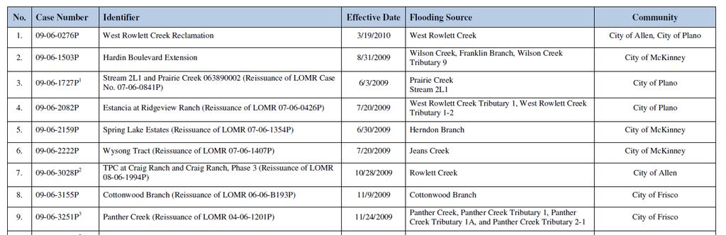
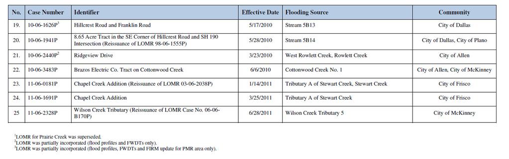
15 LOMR INCORPORATION No. Identifier 1. West Rowlett Creek Reclamation 2. Hardin Boulevard Extension Stream 2L1 and Prairie Creek (Reissuance of LOMR Case No P) 1 4. Estancia at Ridgeview Ranch (Reissuance of LOMR P) 5. Spring Lake Estates (Reissuance of LOMR P) 6. Wysong Tract (Reissuance of LOMR P) TPC at Craig Ranch and Craig 7. Ranch, Phase 3 (Reissuance of LOMR P) Cottonwood Branch (Reissuance of LOMR B193P) Panther Creek (Reissuance of LOMR P) 3 Watters Branch at Exchange Parkway 2 Brookfield Phase II (Reissuance of Case No P) 3 Lakes on Legacy & Heritage Lakes Subdivision (Reissuance of Case No P) No. 13. Identifier Legacy Drive Estates, Phase II (Reissuance of LOMR P) 14. Deer Creek Cottonwood Creek No. 1, For Star Creek Collin County TX Rowlett Creek Exchange Parkway Westbound Lanes 17. Hunters Creek Estates 18. Anselmi Tract, APL001 (Reissuance of LOMR P) 19. Hillcrest Road and Franklin Road Acre Tract in the SE Corner of Hillcrest Road and SH 190 Intersection (Reissuance of LOMR P) 21. Ridgeview Drive Brazos Electric Co. Tract on Cottonwood Creek Chapel Creek Addition (Reissuance of LOMR P) 24. Chapel Creek Addition 25 Wilson Creek Tributary (Reissuance of LOMR Case No B170P) 1 LOMR for Prairie Creek was superseded. 2 LOMR was partially incorporated (flood profiles and FWDTs only). 3 LOMR was partially incorporated (flood profiles, FWDTs and FIRM update for PMR area only). 15
16 LOMRs 16
17 LOMRs 17
 Effective FIRM Revised Area Based")
18 2. Hardin Boulevard Extension - Wilson Creek, Franklin Branch, Wilson Creek Tributary 9 Case Number: P (Panel 0260) Effective FIRM Revised Area Based on LOMR 18
 - Cottonwood Branch")

19 8. Cottonwood Branch (Reissuance of LOMR B193P) - Cottonwood Branch Case Number: P (Panel 0240) Effective FIRM Revised Area Based on LOMR 19


20 16. Rowlett Creek Exchange Parkway Westbound Lanes - Rowlett Creek Case Number: P (Panel 0380) Effective FIRM Revised Area Based on LOMR 20


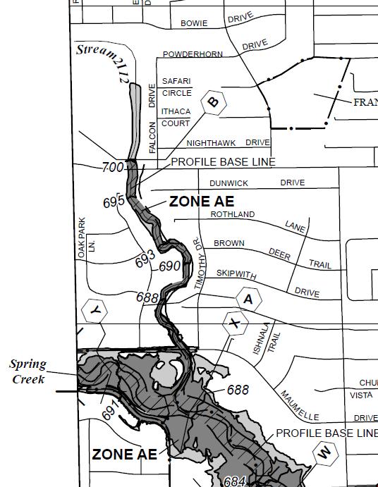
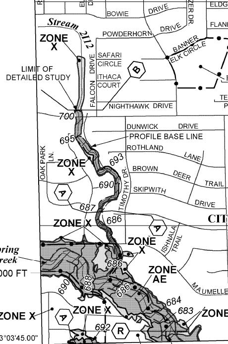
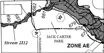
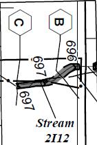
21 17. Hunters Creek Estates - Stream 2I12 Case Number: P (Panels 0370, 0380, & 0390) Effective FIRM Revised Area Based On LOMR 21

 - Stream 5B14 Case Number: 10-06-1941P")
22 Acre Tract in the SE Corner of Hillcrest Road and SH 190 Intersection (Reissuance of LOMR P) - Stream 5B14 Case Number: P (Panel 0370) Effective FIRM Revised Area Based On LOMR 22
23 Draft Floodplain Mapping Product One set of maps provided to each Community for review and comments Panels are in DRAFT form only and cannot be used for permitting or copied Please return any comments by November 9, 2011 An envelope for shipping maps back is provided and UPS labels will be provided immediately after contacting RAMPP study manager 23

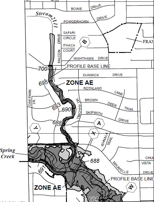
24 Sample Draft Floodplain Mapping Panel 24


25 Significant Areas of Change Panel Prairie Creek 25

26 Significant Areas of Change Panel Stream 5B24 26


27 Significant Areas of Change Panel Stream 5B35 27


28 Significant Areas of Change Panel Stream 5B36 28

29 Schedule Update Preliminary Issuance Target: 12/30/11 Post Preliminary Consists of Three Stages Community Coordination Meeting Appeal Period and Resolution Map Adoption FEMA Publication

30 Information Resources

31 Information Resources 31 31

32 Information Resources 32 32
33 Contact Information - Texas FEMA Project Monitor Ron Wanhanen ronald.wanhanen@fema.dhs.gov FEMA Mitigation Planning Contact Patricia Schaffer Texas NFIP Coordinator Mike Segner Texas Planning Contact Greg Pekar, SHMO Production Lead Contacts Elizabeth Levitz elizabeth_levitz@urscorp.com Andrew Cao andrew_cao@urscorp.com 33
34 Questions? 34

35 Breakouts Draft Floodplain Mapping Review 35
36 36
FIRST AMENDMENT WATERSHED MANAGEMENT AREA 16 MASTER PLAN
 FIRST AMENDMENT WATERSHED MANAGEMENT AREA 16 MASTER PLAN City of Sea Isle City 233 JFK Boulevard Sea Isle City, New Jersey 08243 609-263-4461 (phone) 1962 2016 LEONARD C. DESIDERIO, MAYOR ADMINISTRATION
MEMORANDUM. September 10, 2018
 September 10, 2018 MEMORANDUM TO: Chad Bird, City of Decorah FROM: Larry Weber and Dan Gilles, Iowa Flood Center, IIHR Hydroscience & Engineering COPY TO: Dana Werner, St. Paul District Corps of Engineers,
CHECKLIST FOR PHASE II DRAINAGE REPORT
 I. COVER SHEET CHECKLIST FOR PHASE II DRAINAGE REPORT A. Name of Project B. Address C. Owner D. Developer E. Engineer F. Submittal date and revision dates as applicable II. GENERAL LOCATION AND DESCRIPTION
Existing Conditions and Environmental Consequences Floodplains
 3.9 Environmental Consequences 3.8 3.8.1 WHAT ARE FLOODPLAINS? are low-lying areas adjacent to rivers, streams, and other waterbodies that are susceptible to inundation (flooding) during rain events. These
PCE PRELIMINARY DRAINAGE ANALYSIS REPORT FOR WESTWOOD MIXED USE NEIGHBORHOOD PROJECT 772 NORTH FOREST ROAD TOWN OF AMHERST, ERIE COUNTY, NEW YORK
 PCE PRELIMINARY DRAINAGE ANALYSIS REPORT FOR WESTWOOD MIXED USE NEIGHBORHOOD PROJECT 772 NORTH FOREST ROAD TOWN OF AMHERST, ERIE COUNTY, NEW YORK MAY 19, 2014 Prepared By: Timothy M. Lavocat, P.E., CFM
FLOODPLAIN USE PERMIT APPLICATION COMMUNITY DEVELOPMENT DEPARTMENT W. Ten Mile Road Novi, MI (248)
") FLOODPLAIN USE PERMIT APPLICATION COMMUNITY DEVELOPMENT DEPARTMENT 45175 W. Ten Mile Road Novi, MI 48375 (248) 347-0415 Office Use Only Permit Number: Date Issued: Processed By: Type of Permit: Date: Project
FLOODPLAIN USE PERMIT APPLICATION COMMUNITY DEVELOPMENT DEPARTMENT 45175 W. Ten Mile Road Novi, MI 48375 (248) 347-0415 Office Use Only Permit Number: Date Issued: Processed By: Type of Permit: Date: Project
Floodplain Management Plan 2016 Progress Report
 PREPARED FOR: Borough of Point Pleasant Beach 416 New Jersey Ave. Point Pleasant Beach, NJ 08742 (732) 892-1118 http://www.pointpleasantbeach.org/ PREPARED BY: T&M Associates 11 Tindall Road Middletown,
Blake C. Kronkosky, PE, Ph.D.
 Blake C. Kronkosky, PE, Ph.D. Blake.Kronkosky@statetecheng.com, CELL (512) 663-1954 Education Ph.D., Civil Engineering, Texas Tech University, May 2018: An Engineer's Guide for Estimating 1-Day, 100-Year
City of East Point Comprehensive Floodplain Management Program
 City of East Point Comprehensive Floodplain Management GAFM 2012, 7 th Annual Technical Conference Reza Aral, CFM, CPESC (City of East Point, GA) Shayne Wood, P.E. (CDM Smith) March, 28, 2012 Agenda Overview
7th Avenue Creek Master Plan Development Project. City of St. Charles, IL. IAFSM CONFERENCE March 14, 2018 MARKET
 7th Avenue Creek Master Plan Development Project MARKET City of St. Charles, IL IAFSM CONFERENCE March 14, 2018 7 TH AVENUE CREEK PROJECT AREA 2 2008 RAIN EVENT 3 RESIDENTIAL STRUCTURE FLOODING COMMERCIAL
State Highway 5 Corridor Context Sensitive Master Plan
 ADOPTED June 17, 2014 (Resolution 2014-06-071) Travel Lane Travel Lane 11 11 Median 16 Min State Highway 5 Corridor Context Sensitive Master Plan 1 Prepared for: Prepared by: State Highway 5 Corridor
KYTC and NFIP: Bridging Floodplain Management and Design KAMM CONFERENCE AUGUST 25, 2015
 KYTC and NFIP: Bridging Floodplain Management and Design KAMM CONFERENCE AUGUST 25, 2015 KYTC STATEWIDE DRAINAGE DESIGN Provide Drainage Design Services on an as needed basis: Perform hydraulic analysis
Village of Forest Park. July 27, Sewer Separation Evaluation
 Village of Forest Park July 27, 2015 Sewer Separation Evaluation Presentation Overview Study Background Historic Nature of Forest Park Drainage Scale of Flooding Problem Forest Park Sewer System Background
Regional Mobility & the US 380 Bypass Concept. Informational Meeting February 9, 2017
 Regional Mobility & the US 380 Bypass Concept Informational Meeting February 9, 2017 Purpose and Agenda Purpose: Regional Mobility Issues, Priorities, and Pressures US 380 as a Limited Access Facility
Appendix E Preliminary Location Hydraulic Study
 Appendix E Prepared for: State of Alaska Department of Transportation and Public Facilities Prepared by: HDR Alaska, Inc. 2525 C Street, Suite 305 Anchorage, Alaska 99503 February 2014 This page intentionally
Level 1 Downstream Analysis
 Level 1 Downstream Analysis Newcastle Way Apartments Newcastle, Washington King County April 14, 2014 Revised July 10, 2014 Prepared by: Dean A. Furr, P.E. Reviewed by: Donald Scarberry, P.E. Coffman Engineering,
13. PRELIMINARY PLAT NO MILLS FARM - Vicinity of the southeast corner of 159 th Street and Quivira Road
 13. corner of 159 th Street and Quivira Road 1. APPLICANT: HNTB Corporation is the applicant for this request. 2. REQUESTED ACTION: The applicant is requesting approval of a preliminary plat for a 383-lot
Floodplain Management Strategies in Forsyth County Georgia Association of Floodplain Management 7 th Annual Technical Conference March 2012
 Floodplain Management Strategies in Forsyth County Georgia Association of Floodplain Management 7 th Annual Technical Conference March 2012 Renee Hoge, P.E., CFM Forsyth County Department of Engineering
I. INTRODUCTION. identify long-term capital improvements and rehabilitation measures for the existing drainage system;
 I. INTRODUCTION The Town of Windsor, Colorado is presently experiencing rapid growth and development within the boundaries of several of its major drainage basins. As growth continues within these basins,
NAI Principles In Gwinnett County
 NAI Principles In Gwinnett County By Cornelius Ani, LSIT, CFM Contributors: Adena Fullard, P.E., CPSWQ Rudresh Bihalli, P.E., CFM Ken Kagy, P.E., CPESC, CPSWQ Ligia Negru, M. Sc., CFM Maja Radovic, CPESC,
Fixer Upper. MS4 Post-Construction and Redevelopment. Anthony Betters, CSI City of Waco Environmental Storm Water Compliance
 Fixer Upper MS4 Post-Construction and Redevelopment Anthony Betters, CSI City of Waco Environmental Storm Water Compliance Polly Porter TCEQ Small Business and Local Government Assistance Curtis Beitel,
LITTLE ELM CAPTIAL IMPROVEMENT BOND STREET PRESENTATION
 LITTLE ELM 2009-2014 CAPTIAL IMPROVEMENT BOND STREET PRESENTATION Denton Frisco Little Elm Lewisville Legacy Southlake Grapevine Addison DENTON COUNTY & LEWISVILLE LAKE MATCHING FUNDS DENTON COUNTY BOND
AGENCY: Federal Emergency Management Agency, DHS. SUMMARY: Flood hazard determinations, which may include additions or
 This document is scheduled to be published in the Federal Register on 07/27/2016 and available online at http://federalregister.gov/a/2016-17739, and on FDsys.gov 1 Billing Code 9110-12-P DEPARTMENT OF
2015 International Code Adoption. And 2014 Electrical Code
 2015 International Code Adoption And 2014 Electrical Code Why adopt building codes? Codes establish a minimum standard for life, health and safety for buildings in City of Garland. Intended to provided
PARISH OF ASCENSION OFFICE OF PLANNING AND DEVELOPMENT PLANNING DEPARTMENT. Joint Planning and Zoning Meeting
 1. Call To Order 2. Roll Call of Members 3. Chairman's Comments PARISH OF ASCENSION OFFICE OF PLANNING AND DEVELOPMENT PLANNING DEPARTMENT Joint Planning and Zoning Meeting January 11, 2017 6:00 PM Courthouse
Floodplain Technical Memorandum
 Southeast Extension Project Lincoln Station to RidgeGate Parkway Prepared for: Federal Transit Administration Prepared by: Denver Regional Transportation District May 2014 Table of Contents Page No. Chapter
8.5 FLOODING. Environmental Setting
 8.5 FLOODING This section evaluates flooding impacts associated with the proposed General Plan, including whether implementing the plan will: (1) permit the construction of housing within a 100-year Flood
3/7/2013. Compliance & Sustainability
 Overview www.kieser associates.com Celebrating 20 Years of Excellence in Environmental Science & Engineering WMU Arcadia Creek Stormwater Treatment and Floodplain Enhancement Project DEQ #2008 0018 and
Drexel, Barrell & Co.
 Drexel, Barrell & Co. June 18, 2018 Engineers/Surveyors Boulder Colorado Springs Greeley 3 South 7 th Street Colorado Springs, Colorado 80905-1501 719 260-0887 719 260-8352 Fax El Paso County Planning
Drexel, Barrell & Co.
 Drexel, Barrell & Co. December 21, 2018 Engineers/Surveyors Boulder Colorado Springs Greeley 3 South 7 th Street Colorado Springs, Colorado 80905-1501 719 260-0887 719 260-8352 Fax El Paso County Planning
Gadsden County Planning Commission Agenda Request
 Date of Meeting: November 16, 2017 To: From: Through: Subject: Gadsden County Planning Commission Agenda Request Honorable Chairperson and Members of the Board Jill A. Jeglie, AICP, Senior Planner Clyde
Hunt Highway CELESTE PEMBERTON, CFM, CPM PINAL COUNTY CARLOS SANCHEZ SORIA, PE T.Y. LIN INTERNATIONAL
 Hunt Highway CELESTE PEMBERTON, CFM, CPM PINAL COUNTY CARLOS SANCHEZ SORIA, PE T.Y. LIN INTERNATIONAL Agenda Design Concept Report Phase 1 Phase 2 Phase 3 Phase 4 Phase 5 Questions Design Concept Report
Exhibit A. SH 161 RTC Work Program of New Projects. Collin County
 Exhibit A SH 161 RTC Work Program of New Projects Collin County 0918-24-969 N/A 0918-24-970 N/A 0918-24-973 N/A 2351-01-020 N/A 2679-03-010 N/A On Exchange Parkway from US 75 to Allen Heights On Country
Please highlight flow chart where applicable and return with Form 2 and Form 3 (tab 1) to the City of St. Charles Engineering Department.
 to the City of St. Charles Engineering Department.") Please highlight flow chart where applicable and return with Form 2 and Form 3 (tab 1) to the City of St. Charles Engineering Department. A $50 Permit Application fee should accompany the Permit Application.
Please highlight flow chart where applicable and return with Form 2 and Form 3 (tab 1) to the City of St. Charles Engineering Department. A $50 Permit Application fee should accompany the Permit Application.
Stormwater Regulations & Considerations Morse Study Area. Pam Fortun, P.E. CFM Senior Stormwater Treatment Engineer Engineering Services Division
 Stormwater Regulations & Considerations Morse Study Area Pam Fortun, P.E. CFM Senior Stormwater Treatment Engineer Engineering Services Division Stormwater Regulations Development Considerations Floodplain
AGENCY: Federal Emergency Management Agency, DHS. SUMMARY: Flood hazard determinations, which may include additions or
 This document is scheduled to be published in the Federal Register on 08/18/2016 and available online at http://federalregister.gov/a/2016-19659, and on FDsys.gov 1 Billing Code 9110-12-P DEPARTMENT OF
Request for Statement of Interest in Implementation of the Roosevelt Road Redevelopment Plan
 425 Hillside Avenue Request for Statement of Interest in Implementation of the Roosevelt Road Redevelopment Plan I. INTRODUCTION The is seeking the services of a qualified consulting firm to prepare plans
Master Plan Hydrology Study & Drainage Analysis Arbor Ridge Master Plan Development, City of Beaumont, CA
 Master Plan Hydrology Study & Drainage Analysis Arbor Ridge Master Plan Development, City of Beaumont, CA Proactive Engineering Consultants 1875 California Avenue Corona, CA 92881 Beaumont, CA Bob Brown,
Decision Notice. Proposed Action
 Decision Notice Paving Weld County Road 105 USDA Forest Service Arapaho and Roosevelt National Forest and Pawnee National Grassland Pawnee National Grassland Ranger District Weld County, Colorado November
OVERMOUNTAIN VICTORY TRAIL BURKE CALDELL CORRIDOR FEASIBLITY STUDY REQUEST FOR QUALIFICATIONS CALDWELL COUNTY PATHWAYS
 OVERMOUNTAIN VICTORY TRAIL BURKE CALDELL CORRIDOR FEASIBLITY STUDY REQUEST FOR QUALIFICATIONS CALDWELL COUNTY PATHWAYS Caldwell County Pathways along with our co-partners City of Lenoir, Town of Gamewell,
What Can We Do to Reduce the Impact of Floods? Joe Barron, P.E. Fletcher Group, Inc. 148 River St. Suite 220 Greenville, S.C.
 What Can We Do to Reduce the Impact of Floods? Joe Barron, P.E. Fletcher Group, Inc. 148 River St. Suite 220 Greenville, S.C. 29601 1 Historical highlights of flood management attempts 1726 first New Orleans
4.500 Preston Road Overlay District
 Section 4.500 Preston Road Overlay District 2004 Zoning Ordinance 4.500 Preston Road Overlay District (ZC 98-29; Ordinance No. 98-9-12) 4.501 Purpose To provide appropriate design standards for the use
Lincoln 270. City of Lincoln. Stormwater Management Plan. April 2, 2013
 Lincoln 270 City of Lincoln Stormwater Management Plan April 2, 2013 # 2005.48 Prepared By: Civil Engineering Solutions, Inc. 590 E Street Lincoln, Ca 95648 (916) 645 5700 1.0 Background: The project site
City Council Special Meeting AGENDA ITEM NO. C.
 City Council Special Meeting AGENDA ITEM NO. C. DATE: 01/04/2019 TO: Honorable Mayor and City Council Members SUBJECT: Transit Villages Specific Plan project Study Session (Development Services Director
VALUE OF URBAN DRAINAGE PLANNING AND FLOOD HAZARD REDUCTION PROJECTS IN THE 2013 FLOOD
 VALUE OF URBAN DRAINAGE PLANNING AND FLOOD HAZARD REDUCTION PROJECTS IN THE 2013 FLOOD ANDREW EARLES, PH.D., P.E. WRIGHT WATER ENGINEERS, INC. & KEN MACKENZIE, P.E., CFM UDFCD October 11, 2013 Water Resources
Metropolitan Water Reclamation District of Greater Chicago. Supervising Civil Engineer
 Metropolitan Water Reclamation District of Greater Chicago Green and Gray Infrastructure John P. Murray, P.E., CFM Supervising Civil Engineer STORMWATER MANAGEMENT District conveyed authority in November
City of Elmhurst. Comprehensive Flood Plan. City of Elmhurst. City Council Meeting September 15, 2014
 City of Elmhurst City of Elmhurst Comprehensive Flood Plan City Council Meeting September 15, 2014 City of Elmhurst Presentation Overview Study Background Study Methodology Analysis of Three Additional
Poisoned Park? How Exide s Lead Contamination Risks Frisco s Grand Park
 Frisco City Hall has big plans to transform Stewart Creek into a Grand Park with lots of water features for kids to play in. Poisoned Park? How Exide s Lead Contamination Risks Frisco s Grand Park But
WARSAW WAL-MART EXPANSION FLOODPLAIN EVALUATION STUDY
 WARSAW WAL-MART EXPANSION FLOODPLAIN EVALUATION STUDY BERGMANN ASSOCIATES NOVEMBER 20, 2008 (revised June 8, 2009) TOWN OF WARSAW, WYOMING COUNTY, NEW YORK Memorandum To: Jack Buholtz, PE From: Kenneth
TIMOTHY E. DATERS, P.E. White-Daters & Associates, Inc. 24 Rahling Circle Little Rock, AR (501)
") TIMOTHY E. DATERS, P.E. tdaters@whitedaters.com Graduated from University of Iowa, 1975, BSCE Recipient of Fred Stebler Scholarship Graduated from University of Arkansas, 1983, MSCE PROFESSIONAL ORGANIZATION
TIMOTHY E. DATERS, P.E. tdaters@whitedaters.com Graduated from University of Iowa, 1975, BSCE Recipient of Fred Stebler Scholarship Graduated from University of Arkansas, 1983, MSCE PROFESSIONAL ORGANIZATION
SECTION 4(f) DE MINIMIS DOCUMENTATION
 DE MINIMIS DOCUMENTATION") SECTION 4(f) DE MINIMIS DOCUMENTATION Illinois Route 60/83 IL 176 to the intersection of IL 60 (Townline Road) Lake County P-91-084-07 Mundelein Park and Recreation District Project Limit SECTION 4(f)
SECTION 4(f) DE MINIMIS DOCUMENTATION Illinois Route 60/83 IL 176 to the intersection of IL 60 (Townline Road) Lake County P-91-084-07 Mundelein Park and Recreation District Project Limit SECTION 4(f)
1. Project Description
 To: By: Checked By: Jimmy Vilce, E.I. (FOT istrict 1 Project Manager) Jennifer Nunn, P.E. (The Balmoral Group) Lori Stanfill, P.E. (The Balmoral Group) Memorandum ate: July 10, 2018 Subject: In May of
Chesapeake Bay Critical Area Conservation Plan
 The Maryland-National Capital Park and Planning Commission Prince George s County Planning Department Development Review Division 301-952-3530 Note: Staff reports can be accessed at www.mncppc.org/pgco/planning/plan.htm.
WASHINGTON COUNTY OREGON
 WASHINGTON COUNTY OREGON LONG RANGE PLANNING DIVISION North Bethany Subarea Stream Corridors: Existing Regulations In Oregon, there is a distinct difference between the land use rules that apply in rural
Draft Rhode Island Stormwater Design and Installation Standards Manual
 Draft Rhode Island Stormwater Design and Installation Standards Manual Summary The May 2009 Public Review Draft version of the RI Stormwater Design and Installation Standards Manual consists of approximately
Amy Bouska Urban Conservationist IDALS-Division of Soil Conservation
 Amy Bouska Urban Conservationist IDALS-Division of Soil Conservation Wayne Petersen Wallace Building, Des Moines 515-281-5833 Wayne.petersen@iowaagriculture.gov Derek Namanny Spirit Lake FO 712-336-3782
MASTER DEVELOPMENT DRAINAGE PLAN FOR MONUMENT HEIGHTS
 MASTER DEVELOPMENT DRAINAGE PLAN FOR MONUMENT HEIGHTS DRAINAGE REPORT STATEMENT ENGINEER'S STATEMENT: The attached drainage plan and report were prepared under my direction and supervision and are correct
5. FINAL DEVELOPMENT PLAN APPROVAL MENORAH MEDICAL CENTER OFFICE BUILDING Vicinity of the southwest corner of 119 th Street and Nall Avenue
 5. FINAL DEVELOPMENT PLAN APPROVAL MENORAH MEDICAL CENTER Avenue 1. APPLICANT: Hoefer Wysocki Architects, L.L.C., is the applicant for this request. 2. REQUESTED ACTION: The applicant is requesting final
Northern Branch Corridor DEIS December 2011
 16 Floodplains 161 Chapter Overview 1611 Introduction The flowing chapter identifies floodplains found within the Northern Branch Corridor in accordance with Executive Order 11988, Floodplain Management
Project Overview. Get Involved. Public Information Meeting. Contact Information
 Get Involved VDOT representatives will review and evaluate information received as a result of this meeting. Please fill out the comment sheet provided in this brochure if you have any comments or questions.
City of Fort Lupton Site Plan Process
 Form WKBK001 City of Fort Lupton Site Plan Process Purpose The Site Plan process is meant to promote orderly and sound development standards as they apply to the City. These site development standards
Appendix I. Checklists
 Appendix I Checklists Town of Greenwich Drainage Manual Department of Public Works - Engineering Division Town Hall - 101 Field Point Road, Greenwich, CT 06836-2540 Phone 203-622-7767 - Fax 203-622-7747
Chapter 4 - Preparation of Stormwater Site Plans
 Chapter 4 - Preparation of Stormwater Site Plans The Stormwater Site Plan is the comprehensive report containing all of the technical information and analysis necessary for the City to evaluate a proposed
Cotton Belt Regional Rail Corridor Project
 Cotton Belt Regional Rail Corridor Project North Dallas AFG University of Texas at Dallas Administration Building March 1, 2018 0 Discussion Public Involvement Project Scope Alignment Stations Environmental
Washington County, Maryland Division of Public Works Policy Manual
 Washington County, Maryland Division of Public Works Policy Manual Subject: Downstream Drainage Easement Category: Land Development Engineering Number: 7-4.1 Date: June 1, 2009 (effective) PURPOSE: The
PUBLIC HEARING. Thursday, December 14, 2017 FDOT Urban Office 2198 Edison Avenue Jacksonville, FL 32204
 DISTRICT TWO PUBLIC HEARING I 10 (SR 8) from I 295 to I 95 Project Development & Environment Study Duval County, Florida Financial Project Number 213326 2 22 01 Efficient Transportation Decision Making
Population, Housing, and Employment Analysis
 Population, Housing, and Employment Analysis Reviewed housing development patterns, trends, needs, affordability, and estimated employment and population capacity at full build out. Total 28,200 people
Hazard Mitigation Planning. Association of New Jersey Environmental Commissions Workshop Edison, New Jersey October 20, 2012
 Hazard Mitigation Planning Association of New Jersey Environmental Commissions Workshop Edison, New Jersey October 20, 2012 Mitigation Planning NJ Hazard Mitigation Plan? What is the status of the HMP
NYC DEP s Approach to Flood Mitigation: The Local Flood Analysis (LFA) Process
 Process") NYC DEP s Approach to Flood Mitigation: The Local Flood Analysis (LFA) Process Milone & MacBroom, Inc. Jenabay Sezen, EIT Connecticut Association of Floodplain Managers October 25, 2016 Agenda Introduction
NYC DEP s Approach to Flood Mitigation: The Local Flood Analysis (LFA) Process Milone & MacBroom, Inc. Jenabay Sezen, EIT Connecticut Association of Floodplain Managers October 25, 2016 Agenda Introduction
MOBILE CITY PLANNING COMMISSION LETTER OF DECISION. October 22, 2010
 MOBILE CITY PLANNING COMMISSION LETTER OF DECISION Archbishop of Mobile 400 Government St. Mobile, AL 36602 Re: Case #SUB2010-00075 (Subdivision) 3650 Springhill Avenue (Northwest corner of Springhill
City of Waco Stormwater Management Regulations
 1.0 Applicability: City of Waco Stormwater Management Regulations These regulations apply to all development within the limits of the City of Waco as well as to any subdivisions within the extra territorial
APWA Expo August 27, Ground Water Recharge With Storm Management: A Sustainable Development
 APWA Expo August 27, 2013 Ground Water Recharge With Storm Management: A Sustainable Development Presented by: Joel S. Koenig, P.E. Andrew J. Hawkins Chris P. Dagiantis, P.E., CFM Bios Joel S. Koenig,
Nevada Floodplain Management Program
 Nevada Floodplain Management Program Mt Rose Highway-NHP February 2017 - Courtesy NWS Reno East Fork Carson River January 2017 Douglas County, NV - Courtesy Courtney Walker I 15, Overton 9/10/14 Rye Patch
September 7, Mr. Brant Gary Director of Public Works City of Bellaire 7008 S. Rice Avenue Bellaire, Texas 77401
 September 7, 2016 Mr. Brant Gary Director of Public Works City of Bellaire 7008 S. Rice Avenue Bellaire, Texas 77401 Re: City of Bellaire, Texas FY 2016 Drainage Study Dear Mr. Gary: ARKK Engineers, LLC
Northwest Corridor LRT Line to Irving/DFW Public Meeting No. 1 Project Overview
 LRT Line to Irving/DFW Public Meeting No. 1 Project Overview January 21, 2004 Agenda Purpose Corridor Background Environmental Impact Assessment Public Involvement Plan Project Schedule Purpose Project
PLANNED UNIT DEVELOPMENT & SUBDIVISION STAFF REPORT Date: May 18, 2017
 & PUD-0000102-2017 PLANNED UNIT DEVELOPMENT & SUBDIVISION STAFF REPORT Date: May 18, 2017 NAME SUBDIVISION NAME Dauphin Creek Estates Subdivision Dauphin Creek Estates Subdivision LOCATION CITY COUNCIL
Mapping and the 2013 Colorado Floods. Mapping before, during, and after
 Mapping and the 2013 Colorado Floods Mapping before, during, and after Presented by Outline 2013 Floods Floodplain Mapping Before During After 20 counties 21,000 households 6000 sq. mi. 2,132 NFIP claims
City of Fort Lupton Administrative Site Plan Process
 City of Fort Lupton Administrative Site Plan Process Purpose The Site Plan process is meant to promote orderly and sound development standards as they apply to the City. These site development standards
COMPANY JERALD WINETROUB COMPANY
 LAKELINE PROPERTIES Austin & Cedar Park, Texas JOHN L COMPANY REAL ESTATE INVESTMENTS JOHN C. LEWIS PRESIDENT 1717 WEST 6TH STREET, SUITE390 AUSTIN, TEXAS 78703 TEL (512) 476-7011 CELL (512) 413-8100 john
APPENDIX E. Flood Plain Management
 APPENDIX E Flood Plain Management The Comprehensive Plan incorporates policies of the City s Drainage and Flood Plain Management Plans with the long-term goals of the City. This Appendix provides an overview
C-I-10. The effect of establishing a comprehensive site review as follows will: B. Reduce the cluttered aspects of current development by:
 C-I-10 PART C SECTION I ARTICLE 10 GENERAL REGULATIONS PROJECT SITE REVIEW I. Purpose The effect of establishing a comprehensive site review as follows will: A. Protect streetscapes from projects that
SH 199 Corridor Master Plan. Community Meeting No. 2 May 31, 2017
 Community Meeting No. 2 May 31, 2017 Transportation Projects On or Near SH 199 SH 199 from 0.3 miles south of FM 1886 to south end of Lake Worth bridge Construct freeway mainlanes and frontage roads 10-Year
Memorandum CITY OF DALLAS. Riverfront Boulevard Design From Continental Avenue to Cadiz Street
 Memorandum DATE November 10, 2011 CITY OF DALLAS TO Trinity River Corridor Project Committee Members: Vonciel Jones Hill (Chair) Linda Koop (Vice Chair), Monica Alonzo, Scott Griggs, Angela Hunt, and Delia
CITY OF CHARLOTTESVILLE, VIRGINIA CITY COUNCIL AGENDA
 CITY OF CHARLOTTESVILLE, VIRGINIA CITY COUNCIL AGENDA Agenda Date: December 16, 2013 Action Required: Adoption of Resolution Presenter: Staff Contacts: Title: James E. Tolbert, AICP, Director of NDS James
CITY OF DEERFIELD BEACH Request for City Commission Agenda
 Item: CITY OF DEERFIELD BEACH Request for City Commission Agenda Agenda Date Requested: April 2, 2013 Contact Person: Gerald R. Ferguson, Director of Planning & Development Services Description: 3317,
SEMSWA s Role in the Land Development Process
 SEMSWA s Role in the Land Development Process One of SEMSWA s responsibilities is to ensure that any new development or redevelopment within its service area is designed and constructed in compliance with
AGENDA ITEM: IOWA. west] that were not FISCAL IMPACT. the City of Clive. STAFF REVIEW. Resolution II. Amendment PREPARED BY: REVIEWED BY:
![AGENDA ITEM: IOWA. west] that were not FISCAL IMPACT. the City of Clive. STAFF REVIEW. Resolution II. Amendment PREPARED BY: REVIEWED BY:](/thumbs/93/112428810.jpg "AGENDA ITEM: IOWA. west] that were not FISCAL IMPACT. the City of Clive. STAFF REVIEW. Resolution II. Amendment PREPARED BY: REVIEWED BY:") AGENDA ITEM: CITY OF WAUKEE, IOWA CITY COUNCIL MEETING COMMUNICATION MEETING DATE: March 7, 2016 AGENDA ITEM: Consideration of approval of a resolution approving Engineering Services Amendment No. 1 with
AGENDA ITEM: CITY OF WAUKEE, IOWA CITY COUNCIL MEETING COMMUNICATION MEETING DATE: March 7, 2016 AGENDA ITEM: Consideration of approval of a resolution approving Engineering Services Amendment No. 1 with
FURTHER TO EXECUTIVE COMMITTEE MEETING #11/12 To be held on Friday, January 11, 2013
 FURTHER TO EXECUTIVE COMMITTEE MEETING #11/12 To be held on Friday, January 11, 2013 FURTHER TO: Pages EX10. APPLICATION FOR PERMITS UNDER ONTARIO REGULATION 166/06 Development, Interference with Wetlands
Figure 1 Cypress Street Study Area Location Map
 July 20, 2016 TO: FROM: Jim Massarelli Director of Engineering Jeff Julkowski, PE Michael Burke, PE SUBJECT: Cypress Street Study Area Stormwater Analysis (CBBEL Project No. 16-0058) At the request of
Physical Approaches to Flood Mitigation
 Physical Approaches to Flood Mitigation ational Academy of Sciences /19/2017 Chicago Area Before Development Widespread Flooding Waterways and Marshes Absorbent Ground Early settlers came to this location
Getting the Locals to Go Along. Keys to Tulsa s Successful Floodplain Management
 Getting the Locals to Go Along Keys to Tulsa s Successful Floodplain Management Presented by: Ronald D. Flanagan, CFM Principal Planner Flanagan & Associates, LLC Land-Use & Natural Hazards Planning Consultants
CITY OF MOBILE MOBILE CITY PLANNING COMMISSION LETTER OF DECISION. November 5, 2012
 SAMUEL L. JONES MAYOR CITY OF MOBILE LETTER OF DECISION OFFICE OF THE CITYCOUNCIL COUNCIL MEMBERS REGGIE COPELAND, SR. PRESIDENT-DISTRICT 5 FREDRICK D. RICHARDSON, JR. VICE PRESIDENT-DISTRICT 1 WILLIAM
Environmental Review Part 55 Floodplain Management Subpart C. 8-Step Decision Making Process
 Environmental Review Part 55 Floodplain Management Subpart C 8-Step Decision Making Process - 55.20 Project: Acquisition and Demolition of a Blighted Structure - 1 North Strawberry Avenue, Marietta PA
When planning stormwater management facilities, the following principles shall be applied where possible.
 2.0 Principles When planning stormwater management facilities, the following principles shall be applied where possible. 2.0.1 Drainage is a regional phenomenon that does not respect the boundaries between
COMMUNITY DEVELOPMENT SERVICES PLANNING AND BUILDING DEPARTMENT PLACERVILLE OFFICE:
 COMMUNITY DEVELOPMENT SERVICES PLANNING AND BUILDING DEPARTMENT http://www.edcgov.us/devservices/ PLACERVILLE OFFICE: LAKE TAHOE OFFICE: 2850 Fair Lane Court, Placerville, CA 95667 924 B Emerald Bay Rd.
138 ATTACHMENT 17. DEPARTMENT OF THE ARMY WlLMlNGTON DISTRICT, CORPS OF ENGINEERS
 138 ATTACHMENT 17 DEPARTMENT OF THE ARMY WlLMlNGTON DISTRICT, CORPS OF ENGINEERS B. EVERETT JORDAN DAM AND LAKE P.O. Box 144 MONCURE, NORTH CAROLINA 27559 April 11, 2007 Mr. Scott Radway Radway Design
Santa Cruz River Master Plan. Presented to the Arizona Floodplain Management Association Spring Conference June 8-10, 2011
 Santa Cruz River Master Plan Presented to the Arizona Floodplain Management Association Spring Conference June 8-10, 2011 Introduction Who is FICO? 2 Project Team Kimley-Horn and Associates, Inc. River
Prado Ranch North Common Open Space Tentative Map. Washoe County Planning Commission July 3, 2018
 Prado Ranch North Common Open Space Tentative Map Washoe County Planning Commission July 3, 2018 Site Characteristics Intersection of Chickadee and Lemmon Drive ~1 mile north of Deodar/Lemmon Drive intersection
REQUEST FOR COUNCIL ACTION 6A AGENDA ITEM ORIGINATING DEPT. AGENDA ITEM CITY ADMINISTRATOR APPROVAL
 DATE REQUEST FOR COUNCIL ACTION 6A AGENDA ITEM ORIGINATING DEPT. AGENDA ITEM CITY ADMINISTRATOR APPROVAL Community Development Territorial Greens PUD Concept Plan Development Stage Plan Subdivision (Preliminary
Preliminary Design of Major Rehabilitation Works for the Bridge Structure on PTH 1A Over Assiniboine River and CP Rail (Bridge Site No.
 Preliminary Design of Major Rehabilitation Works for the Bridge Structure on PTH 1A Over Assiniboine River and CP Rail (Bridge Site No. 2582-00) Public Consultation Report December 2014 First Street Bridge