Green Infrastructure. by Karen Engel, NYS DEC. NYS Department of Environmental Conservation
|
|
|
- Clarissa Curtis
- 5 years ago
- Views:
Transcription

1 Green Infrastructure by Karen Engel, NYS DEC

2 What is Green Infrastructure?

3 For some it s all about water Green Infrastructure techniques use soils and vegetation to infiltrate, evapotranspirate, and/or recycle runoff, creating an effective stormwater management system.
4
5


6 The UNH Stormwater Center Dedicated to the protection of water resources through effective stormwater management Research and development of stormwater treatment systems To provide resources to stormwater communities currently involved in design and implementation of Phase II requirements 6
7

8 but GI Does Far More Than That Vegetation and natural systems also help filter air pollutants, reduce energy demands, mitigate urban heat islands, and sequester carbon while also providing communities with aesthetic and natural resource benefits.

9 We always knew trees were pretty, but they also: Improve air quality Improve water quality Reduce stormwater run-off Reduce soil erosion Reduce noise Store carbon Reduce energy costs Reduce crime Increase property values Provide wildlife habitat and more... and now we can prove it!
10
11 So GI means different things to different people, but these are basic common principles: It is or uses natural systems, usually vegetated It has utilitarian value like gray infrastructure It performs critical life-sustaining functions
12

13 and size matters L A N D S C A P E scale to site scale


14 Strategy is key to sustaining a complex, interconnected matrix of natural systems for effective GI. A large-scale plan can help to ensure the most beneficial arrangement of small-scale pieces. Beneficial arrangement Non-beneficial arrangement The Conservation Fund
15 GREEN INFRASTRUCTURE is Green infrastructure is strategically planned and managed networks of natural lands, working landscapes and other open spaces that conserve ecosystem values and functions and provide associated benefits to human populations. The foundation of green infrastructure networks are their natural elements woodlands, wetlands, rivers, grasslands that work together as a whole to sustain ecological values and functions. Healthy functioning natural or restored ecological systems are essential to ensure the availability of the network s ecological services. Additional elements and functions can then be added to the network, depending on the desires and needs of the designers working lands, trails and other recreational features, cultural and historic sites. These all can be incorporated into green infrastructure networks that contribute to the health and quality of life for America s communities. While green infrastructure planning occurs at a broad landscape scale, elements of the over-arching network can be found at all scales, from state-wide, to the county, city, and parcel/site scale. Critical elements of the implementation strategy, such as lowimpact development practices (LID), conservation developments, green/grey interface, etc., are necessary components to any successful green infrastructure plan, and are frequently found at the site/parcel scale. The Conservation Fund

16 Diverse New York

17 Impacts Beyond our Borders


18 GI Projects Funded by the USFS
19 The GI Mapping Project EPA s Healthy Watersheds Initiative provided the funding for The Green Infrastructure Center, Inc. to do the work of Writing a chapter specific to NY in their GI Practitioner s Guide which is available to all Based upon a pilot project they conducted in one NY county. Ulster was selected based upon data considerations, and a variety of factors that contributed to Statewide applicability.
20 Green Infrastructure Center :: Our Mission To assist communities in developing strategies for protecting and conserving their ecological and cultural assets through environmentally-sensitive decisions, lifestyles and planning. Green infrastructure is the interconnected natural systems and ecological processes that provide clean water, air quality and wildlife habitat. Green infrastructure sustains a community s social, economic, and environmental health.
21 Mapping & Assessment Process Create an individual map of every natural resource attribute, as well as for related or impacting features, for which there is data. Layer selected maps to assess relationships, rank assets, evaluate risks, identify opportunities and rank priorities.
22 Data Sources

23 Creating and Utilizing the Maps by Amanda LaValle Coordinator Ulster County Department of the Environment

24 Themed Maps: Overlay key landscape features to see relationships and other natural assets. + Size and shape + Rare, threatened and endangered species + Water quality, aquatic biodiversity + Water abundance = Habitat Core Ranking for Intact Landscape

25 What makes these cores so special? 12,758 acres in size 258 acres of interior wetlands 27 Element Occurrences 12 KM of DEC Class A streams 9,880 acres in protection (77%) 11,543 acres of significant natural communities

26 Themed Map: + Watersheds + Water Quality Rankings = Watersheds with High Quality Waters


.")
27 Small parcels fragment forest into many owners Large parcels create contiguous forest blocks We use local parcel data to determine current and future intactness. Timber Asset = Contiguous Large Forested Parcels (>50 acres). A wildlife asset = > 100 acres

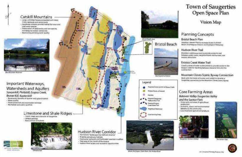
28 Themed Maps: + Forested Land + Land > 50 acres by owner - Protected reserve lands - Slopes > 15 % = Sustainable Forestry Potential

29 Themed Maps + Top fishing areas + Trout waters + State hunting lands and hunt clubs = Hunting and Fishing


30 Themed Maps + Prime (best) agricultural soils + Agricultural Districts - Forested lands = Agricultural Lands

31 Themed Maps + Scenic/land based tourism (wineries, apples, maple sugar) + Scenic routes + National Register properties that are landscape dependent + Hudson River Viewshed = Cultural Resources Supported by the Landscape

32 Risk Assessment What assets are most at risk? Waters deemed impaired by state and EPA, mapped floodplains

33 Of the high quality habitat cores, which are protected, which are not? + Forest Cores + Land under easement, parkland or nature reserve = Protected High Quality Cores

34 34 Linking to the Municipal Level
35 35


36 Town of Saugerties- Open Space Vision Plan How can town level data inform the potential reconnection/ improvement of cores? How can County level cores inform town level efforts?

37 Trees and woodlots Habitat patches Portion of Town of Marbletown Natural Systems Map by Behan Planning Associates, LLC Streams and wetlands Trails and smaller parks Local site plans can be connected to the County plan and visa versa

38 Site to Municipal to County to Regional GI at smaller scales are the pieces of the landscape scale GI puzzle Sites change focus, but still need to connect to larger scales. May require restoration.

39 39 Regional Context- Protected Lands & Centers Mid-Hudson Regional Sustainability Plan


40 40 Connecting to Regional/County Wide Initiatives Cores mapping can be used to link to various regional and county wide efforts including: Ulster County Open Space Plan Greenway Compact for NYS DEC Open Space Plan Mid-Hudson Regional Sustainability Plan Ulster County
41 County Green Infrastructure Mapping Rank assets, assess risks, and determine opportunities What should be protected or restored? Link both ways Down to municipal scale and up to regional scale to connect and improve cores; increasing the size and complexity and strengthening resiliency. Implement Opportunities Include natural asset maps in both daily and long-range planning (park planning, comp plans, updates to open space plans, greenway plans, zoning, tourism and economic development, seeking easements etc).
42 Opportunities for Synergy? NYS DEC s Division of Lands and Forests: NYS Open Space Conservation Plan NYS DEC s Office of Climate Change: Climate Smart Communities Program NYS Energy Research & Development Authority (NYSERDA): Cleaner Greener Communities Program at The Land Use Toolkit at ICLEI-Local Governments for Sustainability: Sustainability Planning Toolkit (formerly the International Council for Local Environmental Initiatives) at
43 So, county planning folks the EPA Healthy Watersheds Initiative supported the Green Infrastructure Center in a pilot project in Ulster County to develop a methodology that you can use to: Inventory your green assets and connections, Identify opportunities for protection and/or restoration, Plan a coordinated strategy to channel development and redevelopment to the most appropriate locations.

44 Green Infrastructure is earth s life-support system. Green Infrastructure is, then, our life-support system.


45 So how much is too much?

46 Avoiding, Mitigating, & Adapting to Disasters
47 Questions to Think About At what point have we cut, mown, cleared, built, paved, poisoned too much? Will we know before we get there? How can I help?


")
48 Ponder the Possibilities with Plants Presentation prepared by: Karen Engel NYS DEC 625 Broadway Albany, NY (518)
Green Infrastructure. NYS Department of Environmental Conservation
 Green Infrastructure Green infrastructure is an interconnected network of natural areas and open spaces that sustains ecosystems. Benedict, M.A. and E.T. McMahon. 2006. Green Infrastructure Linking Landscapes
Green Infrastructure Policies and Ordinances
 Green Infrastructure Policies and Ordinances October 23, 2013 By Karen Firehock, Green Infrastructure Center 2013 Georgia Urban Forest Council s 23 rd Annual Conference The mission of the nonprofit Green
Conservation Corridor Planning and Green Infrastructure Themes
 Conservation Corridor Planning and Green Infrastructure Themes Prepared by the Green Infrastructure Center Inc. and the Northern Virginia Regional Commission February 22, 2011 Brief Overview Project Background
Blue/Green Infrastructure Study Accomack County, VA
 Blue/Green Infrastructure Study Accomack County, VA Draft Asset Maps March 8-9, 2010 Green Infrastructure Center, Inc. 2 Overview What is Green and Blue Infrastructure Project Timeline & Tasks Literature
Climate Smart Communities Green Infrastructure Case Studies
 New York State Water Resources Institute Climate Smart Communities Green Infrastructure Case Studies Emily Vail Hudson River Estuary Program NYS Department of Environmental Conservation Cornell University
Green (and blue) Infrastructure Planning in VA
 Infrastructure Planning in VA") Green (and blue) Infrastructure Planning in VA Presentation to Rural Resiliency Forum By Karen Firehock Oct. 23, 2018 Green Infrastructure Center 2018 Slide Show Topics Definitions: Resilience Green Infrastructure
Green (and blue) Infrastructure Planning in VA Presentation to Rural Resiliency Forum By Karen Firehock Oct. 23, 2018 Green Infrastructure Center 2018 Slide Show Topics Definitions: Resilience Green Infrastructure
Planning for Staten. Habitat Restoration and Green Infrastructure. Island s North Shore
 Habitat Restoration and Green Infrastructure Planning for Staten Island s North Shore Community Board 1 March 1, 2018 NYC Parks Forestry, Horticulture, and Natural Resources Funded by the NYS Department
Countywide Green Infrastructure
 Montgomery County s Countywide Green Infrastructure F U N C T I O N A L M A S T E R P L A N The Maryland National Capital Park and Planning Commission INFRASTRUCTURE An underlying base or foundation especially
STEWARDSHIP OF LONG ISLAND SOUND S ECOLOGICAL AND RECREATIONAL RESOURCES
 STEWARDSHIP OF LONG ISLAND SOUND S ECOLOGICAL AND RECREATIONAL RESOURCES Robin Kriesberg, Save the Sound, Inc. Thomas Halavik, US Fish and Wildlife Service Coastal Program An Initiative to Identify, Protect
National Association of Conservation Districts. Kris Hoellen Vice President, Sustainable Programs The Conservation Fund September 19, 2013
 National Association of Conservation Districts Kris Hoellen Vice President, Sustainable Programs The Conservation Fund September 19, 2013 Our Mission The Conservation Fund forges partnerships to conserve
Green Infrastructure Basics
 1 Green Infrastructure Basics Emily Vail Hudson River Estuary Program NYS Department of Environmental Conservation New York State Water Resources Institute at Cornell University December 8, 2016 2 Presentation
RECREATION, OPEN SPACE AND GREENWAYS ELEMENT GOALS, OBJECTIVES, AND POLICIES
 RECREATION, OPEN SPACE AND GREENWAYS ELEMENT GOALS, OBJECTIVES, AND POLICIES GOAL R-1: DEVELOP A RECREATION, OPEN SPACE AND GREENWAYS SYSTEM AS AN INTEGRAL COMPONENT OF AN OVERALL, COUNTY-WIDE ECONOMIC
Green Infrastructure Planning for Sustainability and Resiliency
 Green Infrastructure Planning for Sustainability and Resiliency Linking Lands and Communities in the Land-of-Sky Region SAMAB Conference - November 18, 2010 www.linkinglands.org Linda Giltz, AICP, Regional
Map Development 5/15/2012. New Virginia Modeling Tools
 Regional Green Infrastructure Base Map Development 5/15/2012 RRRC Land Use & Environment Committee New Virginia Modeling Tools VA Natural Landscape Assessment Forest Habitats Cultural Model Historic Resources
Community Conservation Workshop. Lake Placid
 Community Conservation Workshop Lake Placid 2 Community Conservation Program Welcome! We have designed a Community Conservation Program that listens to the needs of community members. We are conducting
GREEN INFRASTRUCTURE for the U.S.
 GREEN INFRASTRUCTURE for the U.S. Maps and Apps to connect the most valuable landscapes in the nation By Arancha Munoz-Criado Green Infrastructure for the U.S. 1 2 Green Infrastructure for the U.S. What
Figure 1. Proposed Strategic Habitat Conservation Areas for Florida
 Figure 1. Proposed Strategic Habitat Conservation Areas for Florida Critical Lands and Waters Identification Project (CLIP) Cooperative Effort Century Commission for Sustainable Florida Florida Natural
Community Conservation Workshop. Saranac River Basin Communities
 Community Conservation Workshop Saranac River Basin Communities 2 Community Conservation Program Welcome! We have designed a Community Conservation Program that listens to the needs of community members.
TOWN OF BETHLEHEM OPEN SPACE CONSERVATION PLAN PUBLIC MEETING: OCTOBER 12, 2017
 TOWN OF BETHLEHEM OPEN SPACE CONSERVATION PLAN PUBLIC MEETING: OCTOBER 12, 2017 Welcome and Agenda 6:00 6:45: Open House, Part One 6:45 7:15: Presentation and Questions 7:15 8:00: Open House, Part Two
Shared History, Shared Future
 Open Space is Shared History, Shared Future Builds upon past and current regional planning: PSP Action Agenda, Vision 2040, the Cascade Agenda, and Mountains to Sound Greenway The ROSS Approach Building
COMMUNITY ENVIRONMENTAL MANAGEMENT
 COMMUNITY ENVIRONMENTAL MANAGEMENT CEM HANDBOOK FOR COMMUNITY CONSERVATION PLANNING ----- Draft ----- Prepared by the CENTER FOR COMMUNITY ENVIRONMENTAL MANAGEMENT in association with the NEW YORK STATE
Virginia DCR- Natural Heritage Program. Tools for Linking Conservation and Transportation Planning
 Virginia DCR- Natural Heritage Program Tools for Linking Conservation and Transportation Planning November 9, 2009 MISSION: to conserve Virginia's biodiversity through statewide biological inventory, protection,
Tackling Difficult SEQR Topics
 Presented by Nan Stolzenburg AICP CEP and Don Meltz AICP Tackling Difficult SEQR Topics COMMUNITY CHARACTER, HISTORIC/ARCHAEOLOGICAL RESOURCES & HABITATS/ENDANGERED SPECIES Training Agenda Introductions
Minnesota Department of Natural Resource - Natural Resource Guidance Checklist Conserving Natural Resources through Density Bonuses
 Minnesota Department of Natural Resource - Natural Resource Guidance Checklist Conserving Natural Resources through Density Bonuses NRDB Why Use Density Bonuses & This Checklist Local units of government
Toronto Complete Streets Guidelines
 Toronto Complete Streets Guidelines 108 110 7.1 Green Infrastructure Design Principles 112 7.2 Context-Sensitive Green Streets 114 7.3 Key Green Street Elements Green infrastructure refers to natural and
3-2 Environmental Systems
 3-2 Environmental Systems 3.0 ENVIRONMENTAL SYSTEMS CONTENTS 3.1 GREENWAY SYSTEM 3.1.1 General Policies 3.1.2 Natural Heritage Network 3.1.3 Natural Heritage Network Enhancement Lands 3.1.4 Rouge Watershed
Scaling Up Stormwater Green Infrastructure in the Hudson Valley
 1 Scaling Up Stormwater Green Infrastructure in the Hudson Valley Emily Vail Hudson River Estuary Program, NYS Department of Environmental Conservation NYS Water Resources Institute at Cornell University
3.9 Systems Interrelationships
 191 Sustainability Building Blocks: The Comprehensive Plan Systems Community Form Economy Social Transportation Natural Resources Housing and Neighborhoods Utilities and Infrastructure Institutions.9 Systems
Oakland County s Green Infrastructure Vision. L. Brooks Patterson Oakland County Executive
 Oakland County s Green Infrastructure Vision L. Brooks Patterson Oakland County Executive Southeast Michigan 20 miles northwest of Detroit Consists of 910 square miles Population of 1.2 million More than
Aquatic, Terrestrial and Landscape Conservation Design Tools and Products of the North Atlantic LCC
 Aquatic, Terrestrial and Landscape Conservation Design Tools and Products of the North Atlantic LCC Scott Schwenk Science Coordinator, North Atlantic LCC Chesapeake Bay FWS Partners Meeting Annapolis,
NEW GRANTS PROGRAM. Today I will describe what green infrastructure planning entails, how the model works and the importance of the work to planners!
 NEW GRANTS PROGRAM The South Carolina Forestry Commission received funds from the USDA Forest Service s Southern Region to build a green infrastructure landscape scale model and to fund several implementation
Making Data Work for You: Free Mapping Tools for Prioritization and Property Research
 Making Data Work for You: Free Mapping Tools for Prioritization and Property Research Ariel Maiorano amaiorano@massaudubon.org Abby Hardy-Moss abby@ecga.org Essex County Open Space Conference March 25,
Mapping and Planning for Green Infrastructure
 Mapping and Planning for Green Infrastructure Karen Firehock, Executive Director TransportiCA Webinar Series August 30, 2018 Today 1. Green infrastructure defined 2. Mapping green infrastructure in rural
Green Infrastructure
 Statutory Authorization: 24 V.S.A. 4402, 4410, 4414, 4416-4418, 4424 Type: NONREGULATORY & REGULATORY Related Topic Areas: Land Use & Development Regulations; Open Space & Resource Protection Programs
GREEN NETWORK APPLICATIONS IN ESTONIA
 GREEN NETWORK APPLICATIONS IN ESTONIA Kalev Sepp, Tuuli Veersalu, Martk Külvik Estonian University of Life Sciences 1 WHY? BACKGROUND - POLITICAL By adopting the Pan-European Biological and Landscape Diversity
TABLE OF CONTENTS. Transportation Chapter 1 - Introduction and Purpose of Planning to 1-3. Utilities
 Chapter 1 - Introduction and Purpose of Planning... 1-1 to 1-3 Pennsylvania Municipalities Planning Code (Act 247)...1-1 Previous County Planning Activities...1-1 Objectives of the Plan...1-2 Elements
Chapter 5: Natural Resources and Environment
 NATURAL RESOURCES AND ENVIRONMENT 5-1 5 Chapter 5: Natural Resources and Environment BACKGROUND AND INTENT Urban expansion represents the greatest risk for the future degradation of existing natural areas,
FREEDOM S WAY GIS INVENTORY
 APPENDIX F FREEDOM S WAY GIS INVENTORY Freedom s Way National Heritage Area (FWNHA) is required by its enabling legislation to prepare an inventory of natural, historical, and recreational resources within
Recommendations for Municipalities
 Protecting the Kayaderosseras Creek through Better Buffers Recommendations for Municipalities Conservation Committee October 2005 Introduction The Kayaderosseras Creek is a superb natural resource that
OPEN SPACE CHAPTER 7: OVERVIEW. Preserve open space to protect natural resources, enhance character and provide passive recreation opportunities
 CHAPTER 7: OPEN SPACE OVERVIEW Ridgefield has made tremendous progress permanently preserving areas of town as open space. Open space preservation can serve many important purposes, including: protect
Using Green Infrastructure Planning To Support And Enhance Healthy Ecosystems and Communities
 Using Green Infrastructure Planning To Support And Enhance Healthy Ecosystems and Communities by Karen Firehock, Executive Director Green Infrastructure Center Inc. www.gicinc.org A Presentation to Master
New York Green: Mission
 New York Green: Mission Facilitate informed and creative land use decisions that balance nature and economics stimulating sustainable development and preserving a healthy environment. Meeting Overview
Protecting Farmland. The Future of Agriculture in Prince George s County
 Protecting Farmland As demonstrated in the previous section, farmland in Prince George s County is disappearing at a rapid pace. If the loss of farmland continues at this rate, no farmland will be left
Conservation Corridor Base and Thematic Maps
 Conservation Corridor Base and Thematic Maps August 20, 2010 This project is funded in part by the Virginia Coastal Zone Management Program at the Department of Environmental Quality through Grant #NAO9NOS4190163
Planning for and Managing Open Space and Natural Areas
 Planning for and Managing Open Space and Natural Areas Increasingly, development proposals in Delaware include large amounts of open space and natural areas. While open space is important as a community
Overview of Southwestern Pennsylvania Commission s (SPC) 2040 Long Range Transportation Plan (LRTP)
 2040 Long Range Transportation Plan (LRTP)") Overview of Southwestern Pennsylvania Commission s (SPC) 2040 Long Range Transportation Plan (LRTP) Presented to Pennsylvania Agency Coordination Meeting May 27, 2015 Doug Smith & Ryan Gordon 1 Southwestern
Overview of Southwestern Pennsylvania Commission s (SPC) 2040 Long Range Transportation Plan (LRTP) Presented to Pennsylvania Agency Coordination Meeting May 27, 2015 Doug Smith & Ryan Gordon 1 Southwestern
Objective: Resolution to recommend adoption of the Big Thompson Assessment to the Planning Commission
 Type of Meeting: Administrative Matters Name of requestor: Zac Wiebe - 619-4534, Kerri Rollins - 619-4577, Gary Buffington - 619-4560 Department: Natural Resources Preferred appearance date: 8/18/2015
Greenways as an alternative to traditional infrastructure. Green Infrastructure
 Greenways as an alternative to traditional infrastructure Green Infrastructure What is a Greenway? Little (1990) - A linear open space along a natural or human made corridor. Fabos - linked corridors nature
Libby Zemaitis October 18, 2017 Climate Outreach Specialist, NYS DEC Hudson River Estuary Program
 1 Supporting Hudson Riverfront communities as Climate-Adaptive Leaders Libby Zemaitis October 18, 2017 Climate Outreach Specialist, NYS DEC Hudson River Estuary Program The Hudson River Estuary Program
Preface. Erie. Scranton. Allentown. Pittsburgh. Harrisburg. Philadelphia
 The Southern Alleghenies Region The Southern Alleghenies Region spans the Laurel Highlands and Allegheny Front in the west across the Appalachians to the east. It is comprised of Blair, Bedford, Cambria,
Executive Summary Purpose of the Plan Defining Open Space and Greenways
 Executive Summary Bucks County possesses a vast array of open space resources including natural areas, parks, farmland and historic and cultural resources that contribute to a high quality of life valued
One County s Success in Linking Watershed Protection and Land Use Planning
 One County s Success in Linking Watershed Protection and Land Use Planning Bob Thompson Porter County Plan Commission March 28, 2012 Indiana Watershed Leadership Academy Population 160,000 Approximately
SUSTAINABILITY PLAN OTTAWA COUNTY PARKS AND RECREATION COMMISSION FALL 2017
 SUSTAINABILITY PLAN OTTAWA COUNTY PARKS AND RECREATION COMMISSION FALL 2017 Table of Contents Introduction Natural Resources Quality of Life Community Continuing the Mission Sustainability Measuring Sustainability
Municipal Plan*Assessment
 Municipal Plan*Assessment This tool was developed to assist in reviewing municipal master plans and in determining if these plans are consistent with smart growth principles, neighboring municipal plans,
Planning for Staten. Habitat Restoration and Green Infrastructure. Island s North Shore
 Habitat Restoration and Green Infrastructure Planning for Staten Island s North Shore Walker Park December 7, 2017 NYC Parks Forestry, Horticulture, and Natural Resources Funded by the NYS Department of
Regional Freshwater Issues: Stormwater Management and Green Infrastructure April 16, 2011
 Regional Freshwater Issues: Stormwater Management and Green Infrastructure April 16, 2011 New York State Water Resources Institute Emily Vail Hudson River Estuary Program New York State Department of Environmental
RIVER RECREATION AND CONSERVATION: LESSONS FROM COLORADO S 2013 FLOODS
 RIVER RECREATION AND CONSERVATION: LESSONS FROM COLORADO S 2013 FLOODS SORP RMIS May 2016 L O G A N S I M P S O N Agenda Why Are You Here? Land Use Resiliency Public Outreach Dialogue Recreation and Land
The Case for Using Living Green Infrastructure (GI) in Planning Resilient Communities
 in Planning Resilient Communities") The Case for Using Living Green Infrastructure (GI) in Planning Resilient Communities Paul Kraehling, MCIP RPP (Ret.) Rural Studies PhD Candidate Session W2F November 16, 2016 Outline Def n of GI & elements
The Case for Using Living Green Infrastructure (GI) in Planning Resilient Communities Paul Kraehling, MCIP RPP (Ret.) Rural Studies PhD Candidate Session W2F November 16, 2016 Outline Def n of GI & elements
Riparian Buffer on the Bushkill Creek. Policies
 Riparian Buffer on the Bushkill Creek Riparian buffers provide numerous benefits to landowners and the community by protecting groundwater recharge areas, providing flood control, providing stormwater
Natural Environment White Paper & new partnerships to deliver green infrastructure. Henry Smith, Project and Policy Assistant, TCPA
 Natural Environment White Paper & new partnerships to deliver green infrastructure Henry Smith, Project and Policy Assistant, TCPA Presentation outline 1) Green Infrastructure introduction The TCPA s work
Green Infrastructure Enhancing Europe's Natural Capital
 Green Infrastructure Enhancing Europe's Natural Capital Marco Fritz DG ENV.B.2, Biodiversity CIS Working Group on Programmes of Measures 13/11/13 All (c) belong to the authors of the used material. Target
10.0 Open Space and Public Realm
 10.0 Open Space and Public Realm 10.0 Open Space and Public Realm The Public Open Space System is comprised of: outdoor spaces available for public use that are either publicly owned (e.g., parks and
What s Green Infrastructure?
 What s Green Infrastructure? Green infrastructure is strategically planned and managed networks of natural lands, working landscapes and other open spaces that conserve ecosystem values and functions and
Green Genesee Smart Genesee
 Green Genesee Smart Genesee Design Priorities and Principles PREPARED FOR: NYSERDA Jessica Waldorf, Associate Project Manager PREPARED BY: CC Environment & Planning 23 Jackson Street, Batavia, NY 14020
CONSERVATION ELEMENT GOALS, OBJECTIVES, AND POLICIES
 CONSERVATION ELEMENT GOALS, OBJECTIVES, AND POLICIES Goal 4 To conserve, manage, appropriately use and protect the natural resources of the City ensuring continued resource availability and environmental
Green Infrastructure Codes and Ordinances
 1 Green Infrastructure Codes and Ordinances Emily Vail Hudson River Estuary Program NYS Department of Environmental Conservation New York State Water Resources Institute at Cornell University March 19,
RECREATION AND OPEN SPACE VISION
 City of South Lake Tahoe General Plan Policy Document Recreation and Open Space Element INTRODUCTION This element provides the policy context for the City of South Lake Tahoe to achieve its vision for
Woodland Conservation and the Master Plan
 1 WHAT IS A MASTER PLAN? A Vision for the Future of Your Community Woodland Conservation and the Master Plan Goals Objectives Strategies 2 How Will Your Community Look? TREE PRESERVATION AND THE MASTER
Bristol Marsh Heritage Conservancy
 Bristol Marsh Heritage Conservancy The Pennsylvania Environmental Council (PEC) protects and restores the natural and built environments through innovation, collaboration, education and advocacy. PEC believes
The Flow. Green Infrastructure Taking Root in Cities 3/23/2015. Green Infrastructure Evolution City Plans/Projects Measureable and Holistic Benefits
 Green Infrastructure Taking Root in Cities Robert Hopper, P.E. CDM Smith The Flow Green Infrastructure Evolution City Plans/Projects Measureable and Holistic Benefits 2 1 Parts, Systems, Whole The first
Presentation Outcomes
 Green Infrastructure Rappahannock-Rapidan Living Lands Planning Workshop September 17, 2009 Presentation Outcomes Define green infrastructure principles and concepts (video). How are green infrastructure
FINDING WAYS TO CONNECT
 FINDING WAYS TO CONNECT Linking habitat together to function as an ecological whole The Green Leap: A Primer for Conserving Biodiversity in Subdivision Development. Mark E. Hostetler. University of California
Town of Peru Comprehensive Plan Executive Summary
 Town of Peru Comprehensive Plan Executive Communities that plan grow by choice, not by chance. A plan makes growth thoughtful, understandable, and predictable. A plan shows that a community is managing
This program has been registered with LA CES by the New York Upstate This program has been registered with LA CES by the New York Upstate Chapter of
 This program has been registered with LA CES by the New York Upstate This program has been registered with LA CES by the New York Upstate Chapter of the American Society of Landscape Architects. Chapter
Park Board Strategic Framework. (Mission, Vision, Directions, Goals and Objectives) June 27, 2012
 June 27, 2012") Park Board Strategic Framework (Mission, Vision, Directions, Goals and Objectives) June 27, 2012 Planning Process Overview Phase 1: Renewed Strategic Framework Phase 2: Objectives Phase 3: Prioritization
Park Board Strategic Framework (Mission, Vision, Directions, Goals and Objectives) June 27, 2012 Planning Process Overview Phase 1: Renewed Strategic Framework Phase 2: Objectives Phase 3: Prioritization
CHAPTER 8 ISSUES, CONCERNS, CONSTRAINTS AND OPPORTUNITIES
 CHAPTER 8 ISSUES, CONCERNS, CONSTRAINTS AND OPPORTUNITIES Introduction This River Conservation Plan was developed during a time of tremendous activity and effort in planning the transformation of the Delaware
Slope Stability Management Framework
 Slope Stability Management Framework For the assessment, evaluation, prioritization and mitigation of slope stability concerns. 2013/06/19 The Slope Stability Management Framework provides guidance to
INTRODUCING THE BALTIMORE CITY GREEN NETWORK VISION PLAN
 INTRODUCING THE BALTIMORE CITY GREEN NETWORK VISION PLAN GOALS OF THE GREEN NETWORK PLAN Protect and enhance the unique ecological resources of our city Support economic growth and sustainable redevelopment
Working Group Meeting
 April 4,, 2017 Parks Operations Bldg Working Group Meeting Arts Districts Overview Stormwater/RPA/Stream Considerations First Principles Agenda 7:00pm 7:05pm 7:10pm 7:40pm 8:30pm 9:40pm 9:45pm Welcome
Regional Open Space Conservation Plan. Regional Staff Committee January 18, 2018
 Regional Open Space Conservation Plan Regional Staff Committee January 18, 2018 Schedule We are here Task 1 - Stakeholder Input & Work Plan Dev. v z 2016 2017 2018 Oct Nov Dec Jan Feb Mar Apr May Jun Jul
Arlington County Watershed Retrofits. Greg Hoffmann Center for Watershed Protection
 Arlington County Watershed Retrofits Greg Hoffmann Center for Watershed Protection March 18, 2010 About the Center for Watershed Protection Non-profit 501(c)3, non-advocacy organization Work with watershed
Principles for Ecological Landscape Design in Brownfield Business Parks
 Principles for Ecological Landscape Design in Brownfield Business Parks Part of USDA Forest Service research project # 00-JV-11231300-033: Aligning Social and Ecological Drivers of Urban Landscape Change
GUIDELINES FOR ECOLOGICAL PERFORMANCE
 3 Landscape........................................... 3.2 Stormwater Management................................... 3.3 Hardscape........................................... 3.4 Streetscape..........................................
PARKS AND RECREATION
 PARKS AND RECREATION WHAT YOU WILL FIND IN THIS CHAPTER: Background information on the development of the Park, Recreation, and System Plan (PRSP). General overview of Ellensburg s parks and recreation
But What About the People? The Role of Urban Planning and Green Infrastructure
 But What About the People? The Role of Urban Planning and Green Infrastructure The Southeast Conservation Adaptation Strategy: A Model for Collaborative Conservation David Rouse, FAICP, ASLA Managing Director,
{Best Practices. Summary of Tools, Strategies and Best Practices from 11 Michigan Case Study Communities
 Case Studies Michigan Coastal Community Working Waterfronts { Summary of Tools, Strategies and from 11 Michigan Case Study Communities Table of Contents Zoning...2 Community and Stakeholder Collaboration
CHAPTER 1 Introduction
 CHAPTER 1 Introduction From sea to summit, Lane County covers almost 4,800 square miles of diverse Oregon landscape. Stretching from the Pacific Ocean through the Coastal Range, the Willamette Valley to
Slow it, Spread it, Sink it using Green Stormwater Infrastructure
 Milly Archer Water Resources Coordinator Becky Tharp Green Infrastructure Collaborative Slow it, Spread it, Sink it using Green Stormwater Infrastructure Overview Defining LID and GSI Hydrology and impacts
INTRODUCTION TO GREEN INFRASTRUCTURE HOW WE CAN PROTECT OUR COMMUNITIES AND OUR WATERS Maywood Public Library Bergen County, New Jersey
 INTRODUCTION TO GREEN INFRASTRUCTURE HOW WE CAN PROTECT OUR COMMUNITIES AND OUR WATERS Maywood Public Library Bergen County, New Jersey Jeremiah D. Bergstrom, LLA, ASLA Rutgers Cooperative Extension Water
G. RECREATION AND OPEN SPACE ELEMENT. The following summarizes the Recreation and Open Space Element:
 G. RECREATION AND OPEN SPACE ELEMENT The purpose of the Element is to provide the framework and direction for a comprehensive system of public and private sites for recreation, including, but not limited
Putting a LID on Stormwater Pollution. Michele Loudenback, RPES Stormwater Enforcement Water Quality Division
 Putting a LID on Stormwater Pollution Michele Loudenback, RPES Stormwater Enforcement Water Quality Division Outline Brief Regulatory History Conventional vs. Green Practices LID/GI Controls in Use Clean
Local Waterfront Revitalization Programs
 Local Waterfront Revitalization Programs Jaime Ethier Coastal Resources Specialist Mid-Hudson Region Supervisor April 27, 2017 April 27, 2017 2 NYS Coastal Area Roughly 1000 feet inland from these waters
Central Lake Ontario Conservation Conservation Lands Master Plan
 Conservation Lands Master Plan Top 13 Frequently Asked Questions 1. What are conservation lands? Where are these conservation lands located in the Central Lake Ontario Conservation watershed? Conservation
Integrating LEED ND & SITES Into Your Design Approach
 Integrating LEED ND & SITES Into Your Design Approach Joshua C. Sloan, RLA, ASLA, AICP, LEED AP ND, SITES AP Stephen K. Cook, RLA, ASLA, LEED AP O+M VIKA MD, LLC Planning Landscape Architecture Engineering
Arlington, Virginia is a worldclass
 EXECUTIVE S U M M A RY Arlington maintains a rich variety of stable neighborhoods, quality schools and enlightened land use policies, and received the Environmental Protection Agency s highest award for
Karen Firehock. Strategic. Green Infrastructure. Planning. a multi-scale approach
 Karen Firehock Strategic Green Infrastructure Planning a multi-scale approach STRATEGIC GREEN INFRASTRUCTURE PLANNING STRATEGIC GREEN INFRASTRUCTURE PLANNING: A multi-scale approach By Karen Firehock
Appendix E: Illustrative Green Infrastructure Examples
 Appendix E: Illustrative Green Infrastructure Examples Integrating LID into San Francisco s Urban Landscape Figure E. High-density Residential Figure E. Low-density Residential Figure E. Mixed Use 7 Figure
Case studies. B1.1 Lloyds Crossing, Portland (USA)
") B. Case Studies 57 B1 Case studies B1.1 Lloyds Crossing, Portland (USA) Lloyds Crossing in Portland is a brownfields redevelopment site in the central city area, with the aim of: Developing a conceptual
B. Case Studies 57 B1 Case studies B1.1 Lloyds Crossing, Portland (USA) Lloyds Crossing in Portland is a brownfields redevelopment site in the central city area, with the aim of: Developing a conceptual
4. What are the goals of the Kawarthas, Naturally Connected project? 7. What are watersheds and why are they being used as the project boundaries?
 Frequently Asked Questions (FAQs) 1. What are Natural Heritage Systems (NHS)? 2. Why are they important? 3. Which areas of the province have undertaken NHS projects? 4. What are the goals of the Kawarthas,
Land Use Regional Planning in Alberta Collaborating with Stakeholders
 Land Use Regional Planning in Alberta Collaborating with Stakeholders Trevor Lema, Land & Integrated Management Planner September 2018 Overview Why Regional Planning? An Integrated Perspective Integrated