Florida Department of TRANSPORTATION. Technical Memorandum Cultural Resource Assessment Survey of the Proposed VE Pond
|
|
|
- Florence Barber
- 5 years ago
- Views:
Transcription

1 Florida Department of TRANSPORTATION Technical Memorandum Cultural Resource Assessment Survey of the Proposed VE Pond Malabar Road (SR 514) PD&E Study From East of Babcock Street (SR 507) to US 1 Brevard County, Florida FPID: ETDM: The environmental review, consultation, and other actions required by applicable federal environmental laws for this project are being, or have been, carried out by the Florida Department of Transportation (FDOT) pursuant to 23 U.S.C. 327 and a Memorandum of Understanding (MOU) dated December 14, 2016 and executed by the Federal Highway Administration and FDOT. September
2 Florida Department of TRANSPORTATION Technical Memorandum Cultural Resource Assessment Survey of the Proposed VE Pond Malabar Road (SR 514) PD&E Study From East of Babcock Street (SR 507) to US 1 Brevard County, Florida FPID: ETDM: September 2015 Prepared By SEARCH 700 North 9th Avenue Pensacola, Florida
3
4 TECHNICAL MEMORANDUM CULTURAL RESOURCE ASSESSMENT SURVEY OF THE PROPOSED VE POND IN SUPPORT OF THE WIDENING OF SR 514/MALABAR ROAD BREVARD COUNTY, FLORIDA CONSULTANT: SEARCH San Jose Blvd., Suite 204, Jacksonville, FL PRINCIPAL INVESTIGATOR: Melissa M. Dye, MA, RPA ARCHITECTURAL HISTORIAN: Mikel Travisano, MS CLIENT: FDOT, District 5 DATE: September 2015 FM#: This technical memorandum details the results of a Cultural Resource Assessment Survey (CRAS) of one proposed pond associated with the Project Development and Environment (PD&E) Study for the proposed widening of State Road (SR) 514/Malabar Road at US 1 in Brevard County, Florida. The approximately 0.44 acre pond currently under study is located in the town of Malabar (Figure 1). The Florida Department of Transportation (FDOT), District 5, is proposing to widen the existing roadway from two to four lanes along this portion of SR 514/Malabar Road. This technical memorandum serves as an addendum to the 2014 SEARCH report titled Cultural Resource Assessment Survey for SR 514 (Malabar Road) from Babcock Road to US 1, Brevard County, Florida (SEARCH 2014, Florida Master Site File [FMSF] Survey No ). The regional prehistory and history, environment, research design, and field and laboratory methods in this addendum are consistent with those described in the previous report and are not repeated here. The purpose of the survey was to locate, identify, and bound any archaeological resources, historic structures, and potential districts within the project s APE and to assess their potential for listing in the National Register of Historic Places (NRHP). This study was conducted to comply with Chapter 267 of the Florida Statutes and Rule Chapter 1A 46, Florida Administrative Code. All work was performed in accordance with Part 2, Chapter 12 of the FDOT s Project Development & Environment (PD&E) Manual (revised January 1999) and Cultural Resource Management Handbook (revised November 2004), as well as the Florida Division of Historical Resources (FDHR) recommendations for such projects as stipulated in the FDHR s Cultural Resource Management Standards & Operations Manual, Module Three: Guidelines for Use by Historic Preservation Professionals. The Principal Investigator for this project meets the Secretary of the Interior s Standards and Guidelines for Archaeology and Historic Preservation (48 FR ). This study also complies with Public Law (Title 54 U.S.C.), which 1
 Figure 1.")
5 September 2015 SEARCH Final Report CRAS of Proposed VE Pond along SR 514, Brevard County, Florida (FM# ) Figure 1. Location of the proposed VE Pond in Brevard County, Florida. 2
6 SEARCH September 2015 CRAS of Proposed VE Pond along SR 514, Brevard County, Florida (FM# ) Final Report incorporates the provisions of the National Historic Preservation Act (NHPA) of 1966, as amended, and the Archeological and Historic Preservation Act of 1979, as amended. The study also complies with the regulations for implementing NHPA Section 106 found in 36 CFR Part 800 (Protection of Historic Properties). The Area of Potential Effect (APE) was developed to consider any visual, audible, and atmospheric effects that the project may have on historic properties. The APE defined for this project includes the proposed pond footprint in addition to a 100 foot buffer (Figure 2). LOCATION AND MODERN CONDITIONS The proposed VE Pond is located within Section 31 of Township 28 South, Range 38 East, in a wooded area northwest of the intersection of SR 514/Malabar Road and US 1. The terrain is relatively flat with elevations ranging from 28 to 30 feet above mean sea level (amsl). The nearest hydrological feature is the Indian River, located approximately 100 meters to the east. This large navigable waterway opens to the Atlantic Ocean approximately 12 miles south of the project APE at Orchid Island. Vegetation within the APE consists of oak, palmetto, and dense Brazilian pepper and grape vine. Soils within the APE are excessively drained sand (Figure 3). HISTORIC MAP AND AERIAL REVIEW Historic maps and aerial photographs were examined in order to identify past land use in the vicinity of the VE Pond APE. The earliest maps reviewed were the General Land Office (GLO) survey maps created by state land surveyors in the first half of the nineteenth century. These maps characteristically show landscape features such as vegetation, bodies of water, roads, and Spanish land grants. The level of detail in GLO maps varies, with some also depicting structures, Indian villages, railroads, and agricultural fields. GLO survey maps of the area were first created in 1845 (GLO 1845). This map gives no indication of human settlement in or around the project area (Figure 4). A dependent resurvey was completed in 1859 and shows no changes to the project area (GLO 1859) (Figure 5). Both maps show land divided into plots but offer little information about ownership, as much of this land remained sparsely inhabited until around the 1880s. By 1886 the region had experienced some growth, and the settlement of Malabar was depicted on maps from the period (Gray 1886). By 1889, the Florida East Coast (FEC) Railroad traveled along the Atlantic Coast and passed through Malabar (Wm. M. Bradley and Bros. 1889). Upon completion, the FEC stretched from Jacksonville to Key West, and the stretch of rail line that traveled through Malabar was initially called the Jacksonville, St. Augustine, and Indian River Railway (Bramson 2003; Turner 2008). The 1920s brought increased automobile traffic and the addition of state and federal highways, including SR 4/US 1 which runs through Malabar. A 1936 Florida state highway map shows US 1/State Highway 4 and the FEC Railroad running on 3
 Figure 2.")
7 September 2015 SEARCH Final Report CRAS of Proposed VE Pond along SR 514, Brevard County, Florida (FM# ) Figure 2. Proposed VE Pond APE, Brevard County, Florida. 4
 Final Report Figure 3.")
8 SEARCH September 2015 CRAS of Proposed VE Pond along SR 514, Brevard County, Florida (FM# ) Final Report Figure 3. Soil drainage within the VE Pond APE. 5
 Figure 4.")
9 September 2015 SEARCH Final Report CRAS of Proposed VE Pond along SR 514, Brevard County, Florida (FM# ) Figure General Land Office Map with VE Pond APE. 6
 Final Report Figure 5. 1859 General Land Office Map with VE Pond APE.")
10 SEARCH September 2015 CRAS of Proposed VE Pond along SR 514, Brevard County, Florida (FM# ) Final Report Figure General Land Office Map with VE Pond APE. 7
11
 Final Report Figure 6.")
12 SEARCH September 2015 CRAS of Proposed VE Pond along SR 514, Brevard County, Florida (FM# ) Final Report Figure Florida State Road Department map of Malabar. 9
 Figure 7. 1943 US Department of Agriculture aerial photograph. 10")
13 September 2015 SEARCH Final Report CRAS of Proposed VE Pond along SR 514, Brevard County, Florida (FM# ) Figure US Department of Agriculture aerial photograph. 10
 Final Report Figure 8. 1951 US Department of Agriculture aerial photograph of Brevard County.")
14 SEARCH September 2015 CRAS of Proposed VE Pond along SR 514, Brevard County, Florida (FM# ) Final Report Figure US Department of Agriculture aerial photograph of Brevard County. 11
 Figure 9. 1969 US Department of Agriculture aerial photograph of Brevard County.")
15 September 2015 SEARCH Final Report CRAS of Proposed VE Pond along SR 514, Brevard County, Florida (FM# ) Figure US Department of Agriculture aerial photograph of Brevard County. 12
16
17
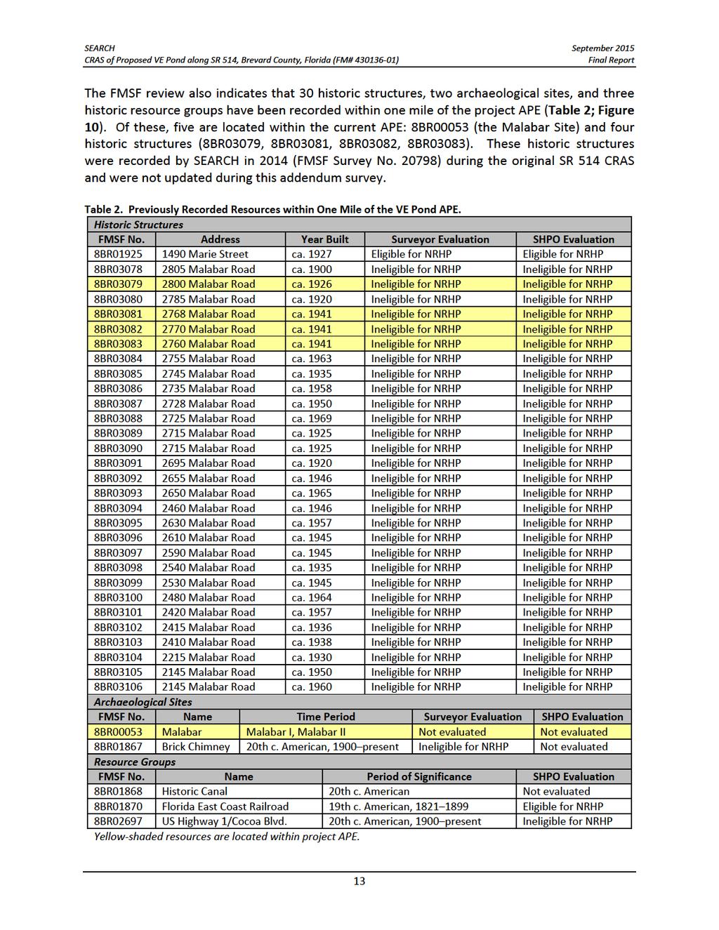
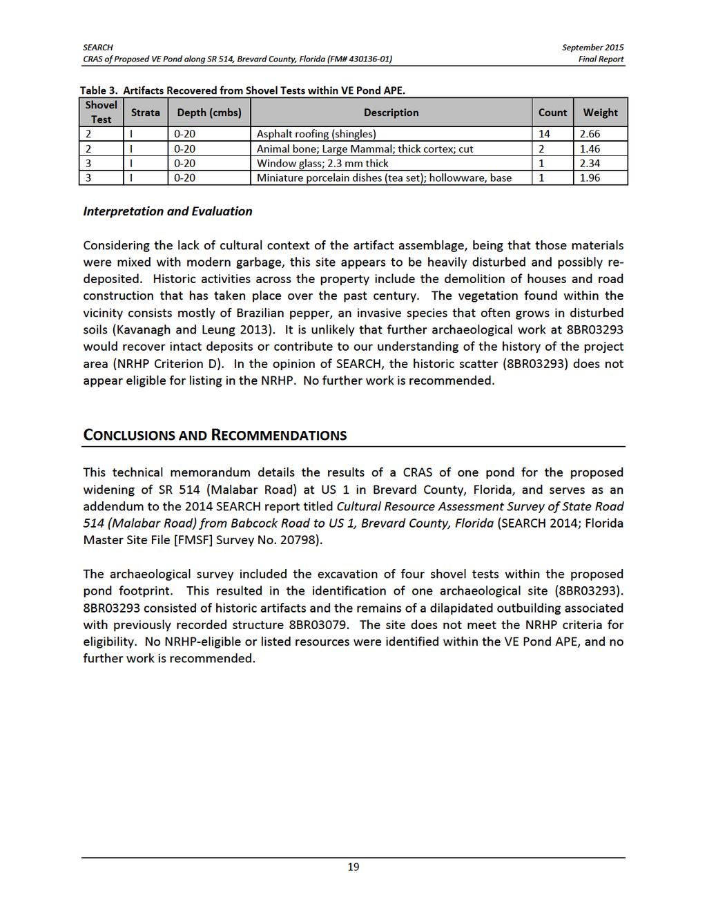
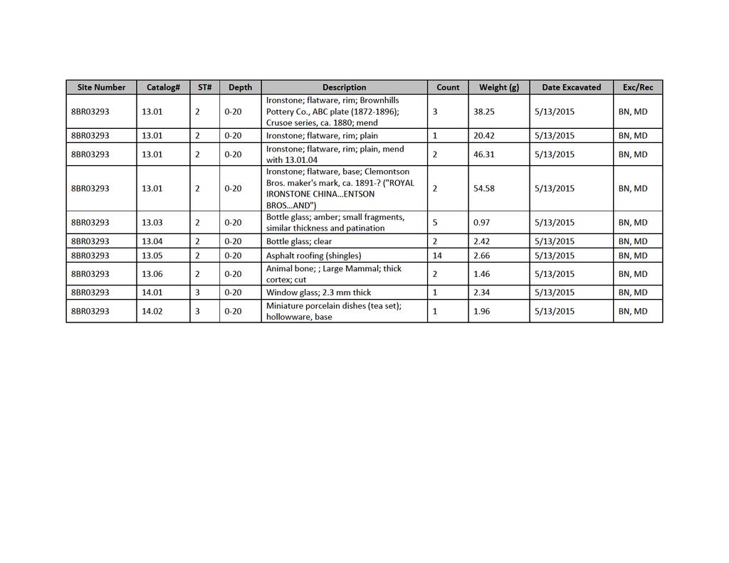
18 SEARCH September 2015 CRAS of Proposed VE Pond along SR 514, Brevard County, Florida (FM# ) Final Report Site 8BR00053 was first noted in 1884; however, it was not formally recorded with the State of Florida until Irving Rouse s survey of the Indian River in the late 1940s (Rouse 1951). To date, this site has not been evaluated for NRHP eligibility by the Florida SHPO. The site was recorded as a shell heap and contains Post Archaic pottery dating to the Malabar I and II periods. SEARCH is currently conducting Phase II National Register eligibility testing at 8BR00053 in support of the SR 514 project. SURVEY RESULTS Archaeology Results Information regarding soil drainage characteristics, proximity to water, and previously recorded resources was examined in order to develop testing strategies for the proposed pond. The VE Pond was determined to have high potential for archaeological sites based on the excessively drained soils, proximity to the Indian River, and the presence of known archaeological sites nearby. In total, four shovel tests were excavated within the proposed pond boundary, which is approximately 0.4 acres in size (Figure 11). The shovel tests typically revealed very dark graybrown sand from 0 to 20 centimeters below surface (cmbs) (0 8 inches) over yellow brown sand to 100 cmbs (39 inches). One archaeological site (8BR03293) was identified as a result of the archaeological survey. Attachment 1 contains the Field Specimen Log for artifacts recovered during the survey. The Survey Log Sheet is included as Attachment 2. Two positive shovel tests were excavated on the west end of the pond, producing historic artifacts and modern garbage in the first strata (plowzone). In the center of the proposed pond is a dilapidated structure heavily overgrown with grape vines and Brazilian peppers (Figure 12). The footprint of the proposed pond from the structure west to the positive shovel tests is inaccessible due to that vegetation. Modern garbage was also noted on the surface across the proposed pond, and is likely associated with several homeless camps scattered across the property. The property to the immediate north of the proposed pond boundary has been recently cleared, and extensive modern garbage was noted on the surface. The deposits of trash in the VE Pond APE may also be a result of the activities to the north. 15
19
20 SEARCH September 2015 CRAS of Proposed VE Pond along SR 514, Brevard County, Florida (FM# ) Final Report Figure 12. Views of structure associated with 8BR03293; view west toward structure (above), close view of door and front window (bottom left), view of structure s interior (bottom right). 17
21
22
23 September 2015 SEARCH Final Report CRAS of Proposed VE Pond along SR 514, Brevard County, Florida (FM# ) REFERENCES CITED Bramson, Seth 2003 Speedway to Sunshine: The Story of the Florida East Coast Railway. Boston Mills Press, Buffalo, NY. Environmental Services, Inc A Cultural Resource Reconnaissance Survey of the Paladin Shores Tract, Brevard County, Florida. Florida Master Site File Survey No On file, Florida Division of Historical Resources, Tallahassee. Florida Department of Transportation (FDOT) 1989 Report of Supplemental Investigation, State Project No Florida Master Site File Survey No On file, Florida Division of Historical Resources, Tallahassee. Florida State Road Department 1936 Malabar. Online document, accessed July 21, General Land Office 1845 Township 28 South, Range 38 East. Online document, accessed July 20, Township 28 South, Range 38 East. Online document, accessed July 20, Gray, Ormando Willis 1886 Gray s Atlas. O. W. Gray and Son, Philadelphia. Online document, accessed July 20, Janus Research 2001 Cultural Resource Assessment Survey for the Interstate 95 PD&E Study from State Road 514 to State Road 50, Brevard County, Florida. Florida Master Site File Survey No On file, Florida Division of Historical Resources, Tallahassee. Kavanagh and Leung 2013 Florida Trees and Wildflowers: A Pocked Guide to Familiar Species. Waterford Press Inc. Rouse, Irving 1951 A Survey of Indian River Archaeology. Yale University Publications in Anthropology. New Haven. 20
24 SEARCH September 2015 CRAS of Proposed VE Pond along SR 514, Brevard County, Florida (FM# ) Final Report SEARCH 2003 Phase I Cultural Resource Survey of the Marie Lakes Project, Brevard County, Florida. Florida Master Site File Survey No On file, Florida Division of Historical Resources, Tallahassee Cultural Resource Assessment Survey for SR 514 (Malabar Road) from Babcock Road to US 1, Brevard County, Florida. Florida Master Site File Survey No On file, SEARCH, Newberry, Florida. Turner, Gregg M A Journey into Florida Railroad History. University Press of Florida, Gainesville. US Department of Agriculture (USDA) 1943 Aerial Photographs: Brevard County. Online document, accessed July 20, Aerial Photographs: Brevard County. Online document, accessed July 20, Aerial Photographs: Brevard County. Online document, accessed July 20, US Geological Survey (USGS) 1980 Topographical Map of Melbourne East, Florida. Online documents, accessed July 20, Wm. M. Bradley and Bros Bradley s Atlas of the World for Commercial and Library Reference. Wm. M. Bradley and Bros, Philadelphia. Online document, accessed July 20,
25 September 2015 SEARCH Final Report CRAS of Proposed VE Pond along SR 514, Brevard County, Florida (FM# ) This page intentionally left blank. 22
26 ATTACHMENT 1: FIELD SPECIMEN (FS) LOG
27
28
29
Technical Memorandum: Cultural Resource Assessment Survey of Proposed Improvements to
 Technical Memorandum: Cultural Resource Assessment Survey of Proposed Improvements to Segment 5: State Road 400 (SR 400)/Interstate 4 (I 4) from West of SR 25/US 27 to West of CR 532 (Polk/Osceola County
PUBLIC HEARING. Thursday, December 14, 2017 FDOT Urban Office 2198 Edison Avenue Jacksonville, FL 32204
 DISTRICT TWO PUBLIC HEARING I 10 (SR 8) from I 295 to I 95 Project Development & Environment Study Duval County, Florida Financial Project Number 213326 2 22 01 Efficient Transportation Decision Making
CULTURAL RESOURCE ASSESSMENT SURVEY TECHNICAL MEMORANDUM
 CULTURAL RESOURCE ASSESSMENT SURVEY TECHNICAL MEMORANDUM INTERCHANGE RECONSTRUCTION I-75 AT FRUITVILLE ROAD (SR 780) INTERCHANGE SARASOTA COUNTY, FLORIDA Financial Project ID No.: 420613-2-52-01 The environmental
2.1.8 Cultural Resources Regulatory Setting. Affected Environment, Environmental
 REVISED DRAFT ENVIRONMENTAL IMPACT REPORT/ Affected Environment, Environmental 2.1.8 Cultural Resources This section evaluates the potential for historical and archaeological resources within the proposed
Phase One Archaeological Investigation Results, James Madison Park Master Development Plan Project, City of Madison, Dane County, Wisconsin
 Phase One Archaeological Investigation Results, James Madison Park Master Development Plan Project, City of Madison, Dane County, Wisconsin Prepared for the City of Madison Parks Department 28 January
Summary of Other State Archeological Guidelines
 Summary of Other State Archeological Guidelines This is a summary all guidelines for archeology from 17 other states. This information was gathered in order to see what type of guidelines other states
AN ARCHAEOLOGICAL SURVEY FOR THE RICHARDS, TEXAS FARM-TO-MARKET ROAD 149 FIBER OPTIC CABLE PROJECT IN MONTGOMERY COUNTY, TEXAS
 AN ARCHAEOLOGICAL SURVEY FOR THE RICHARDS, TEXAS FARM-TO-MARKET ROAD 149 FIBER OPTIC CABLE PROJECT IN MONTGOMERY COUNTY, TEXAS Antiquities Permit 6097 By William E. Moore Brazos Valley Research Associates
Appendix E Memorandum of Agreement between FHWA and the SHPO
 Appendix E between FHWA and the SHPO MEMORANDUM OF AGREEMENT BETWEEN THE FEDERAL HIGHWAY ADMINISTRATION AND THE FLORIDA STATE HISTORIC PRESERVATION OFFICER PURSUANT TO 36 CFR PART 800 REGARDING THE WEKIVA
Public Hearing. Charlotte County-Punta Gorda MPO - Meeting Rooms A and B March 14, open house at 4 p.m., formal presentation at 5 p.m.
 Public Hearing Charlotte County-Punta Gorda MPO - Meeting Rooms A and B March 14, 2019 open house at 4 p.m., formal presentation at 5 p.m. Welcome to the Public Hearing for the Harborview Road (CR 776)
Public Information/Cultural Resources Committee Workshop August 15, Florida Department of Transportation District One
 Public Information/Cultural Resources Committee Workshop August 15, 2012 Florida Department of Transportation District One SR 542 from 1 st Street to E. of Buckeye Loop Road Winter Haven, Polk County FPID#
PennDOT. single spann lanes and 3- mayy need to be to accommodate. any bridge. addition to III. Date: CRP 07/27/2015 CRP.
 (10/27/14) PennDOT Section 106 Field Assessments and Finding Combined Early tification/finding? Yes Concurrence required or requested: Yes MPMS: 51507 ER# (if consultation with PHMC required) ): County:
AN ARCHAEOLOGICAL SURVEY FOR THE NAVIDAD RESOURCES, LLC FERGUSON STATE PRISON FARM UNIT PROJECT IN MADISON COUNTY, TEXAS
 AN ARCHAEOLOGICAL SURVEY FOR THE NAVIDAD RESOURCES, LLC FERGUSON STATE PRISON FARM UNIT PROJECT IN MADISON COUNTY, TEXAS Antiquities Permit 5714 By William E. Moore Brazos Valley Research Associates Contract
W.H. Bonner Associates
 15619 Ogram Avenu Gardena, CA 90249-444 W.H. Bonner Associates Archaeofaunal Studies Archaeological Surveys Historical & Genealogical Research (310) 675-274 E-mail: whbonner@aol.com April 21, 2014 Wendy
North River Mills Bridge Hampshire County State Project # S314-45/ Federal Project # ARRA-4520(003)D FR#: HM-1
D FR#: HM-1") North River Mills Bridge Hampshire County State Project # S314-45/20-2.40 02 Federal Project # ARRA-4520(003)D FR#: 10-1463-HM-1 STATE LEVEL OF HISTORIC DOCUMENTATION November 2010 West Virginia Department
North River Mills Bridge Hampshire County State Project # S314-45/20-2.40 02 Federal Project # ARRA-4520(003)D FR#: 10-1463-HM-1 STATE LEVEL OF HISTORIC DOCUMENTATION November 2010 West Virginia Department
Chapter 2: PROJECT METHODS
 Chapter 2: PROJECT METHODS The primary goal of the reconnaissance level survey is to identify areas of the City which are potentially eligible for preservation as either historic or conservation districts,
Eastern Terminus TECHNICAL MEMORANDUM CENTRAL BROWARD EAST-WEST TRANSIT ANALYSIS BROWARD COUNTY, FLORIDA
 Eastern Terminus TECHNICAL MEMORANDUM CENTRAL BROWARD EAST-WEST TRANSIT ANALYSIS BROWARD COUNTY, FLORIDA FINANCIAL PROJECT ID NUMBER 411189-2-22-01 FLORIDA DEPARTMENT OF TRANSPORTATION DISTRICT 4 Prepared
DRAFT MAP AMENDMENT FLU 04-4
 DRAFT MAP AMENDMENT FLU 04-4 SW 24 TH AVENUE ROADWAY CORRIDOR The University of Florida participates with the Metropolitan Transportation Planning Organization (MTPO) in its responsibilities for the continuing,
CITY OF LAKEWOOD 2012 THREE-MILE PLAN
 CITY OF LAKEWOOD 2012 THREE-MILE PLAN SECTION 1: INTRODUCTION This document constitutes the s Three-Mile Plan for the unincorporated area three miles in width around the City s perimeter, as required by
STAGE 1 ARCHAEOLOGICAL ASSESSMENT OF RATHBURN ROAD, FROM DUKE OF YORK BOULEVARD TO SHIPP DRIVE, CITY OF MISSISSAUGA. Submitted to:
 STAGE 1 ARCHAEOLOGICAL ASSESSMENT OF RATHBURN ROAD, FROM DUKE OF YORK BOULEVARD TO SHIPP DRIVE, CITY OF MISSISSAUGA Submitted to: McCormick Rankin Corporation 2655 North Sheridan Way, Suite 280 Mississauga,
STAFF REPORT FOR STANDARD COASTAL DEVELOPMENT PERMIT #CDP FEBRUARY 26, 2015 CPA - 1 PO BOX 238 APTOS, CA 94001
 STAFF REPORT FOR STANDARD COASTAL DEVELOPMENT PERMIT #CDP 2014-0030 FEBRUARY 26, 2015 CPA - 1 OWNER/APPLICANT: AGENT: REQUEST: HANS HEIM PO BOX 238 APTOS, CA 94001 JAMES HAY PO BOX 762 MENDOCINO, CA 95460
AASHTO SUBCOMMITTEE ON DESIGN. June 15, 2006 MARK ROBINSON, P.E. DISTRICT 5 INTERSTATE PROGRAM MANAGER FLORIDA DEPARTMENT OF TRANSPORTATION
 AASHTO SUBCOMMITTEE ON DESIGN June 15, 2006 MARK ROBINSON, P.E. DISTRICT 5 INTERSTATE PROGRAM MANAGER FLORIDA DEPARTMENT OF TRANSPORTATION CENTRAL FLORIDA INTERSTATE 4 FACTS Trucks and Others 12% Tourist
Archaeological Survey Report
 Archaeological Survey Report for UNION STREET RAILROAD BRIDGE (Trail Connection Project) Key No. 11085 ODOT, Region 2 Local Agency On-Call ATA 23456 WOC 1 City of Salem, Urban Development HDR Project No.
Employing Non-Invasive Remote Sensing Technology in Cultural Resource Investigations Ashley E. Jones, M.A., RPA Project Archaeologist
 Employing Non-Invasive Remote Sensing Technology in Cultural Resource Investigations Ashley E. Jones, M.A., RPA Project Archaeologist April 19, 2018 Raba Kistner San Antonio (HQ) Austin Brownsville Dallas/Fort
Florida Department of Transportation 1000 NW 111th Avenue Miami, FL
 RON DESANTIS GOVERNOR Florida Department of Transportation 1000 NW 111th Avenue Miami, FL 33172-5800 KEVIN J. THIBAULT SECRETARY The environmental review, consultation and other actions required by applicable
September 26, Ms. Elizabeth Hughes State Historic Preservation Officer Maryland Historical Trust 100 Community Place Crownsville MD
 September 26, 2018 Ms. Elizabeth Hughes State Historic Preservation Officer Maryland Historical Trust 100 Community Place Crownsville MD 21032-2023 Dear Ms. Hughes: Introduction and Project Description
Draft Environmental Assessment Appendix A. SHPO Correspondence, January 19, 2017
 Draft Environmental Assessment Appendix A. SHPO Correspondence, January 19, 2017 Rosecrans/Marquardt Grade Separation Project April 2018 Federal Railroad Administration U.S. Department 1200 New Jersey
TRANSPORTATION ELEMENT GOALS, OBJECTIVES, AND POLICIES
 TRANSPORTATION ELEMENT GOALS, OBJECTIVES, AND POLICIES GOAL 2 The City shall provide a safe, convenient, effective, and energy efficient multimodal transportation system which is coordinated with the Future
MEMORANDUM AGENDA ITEM #IV.C
 MEMORANDUM AGENDA ITEM #IV.C DATE: NOVEMBER 27, 2017 TO: FROM: COUNCIL MEMBERS STAFF SUBJECT: LOCAL GOVERNMENT COMPREHENSIVE PLAN PROPOSED AND ADOPTED AMENDMENT CONSENT AGENDA Pursuant to Section 163.3184,
SUMMARY Downtown Malabar Meeting on July 30, 2013 State Road (SR) 514 (Malabar Road) Project Development and Environment (PD&E) Study
 514 (Malabar Road) Project Development and Environment (PD&E) Study") SUMMARY Downtown Malabar Meeting on July 30, 2013 State Road (SR) 514 (Malabar Road) Project Development and Environment (PD&E) Study www.sr514malabar.com LOCATION: TIME: ATTENDEES: Malabar Town Hall 2725
SUMMARY Downtown Malabar Meeting on July 30, 2013 State Road (SR) 514 (Malabar Road) Project Development and Environment (PD&E) Study www.sr514malabar.com LOCATION: TIME: ATTENDEES: Malabar Town Hall 2725
AWH REPORT OF THE PLANNING AND DEVELOPMENT DEPARTMENT FOR APPLICATION FOR REZONING ORDINANCE TO PLANNED UNIT DEVELOPMENT
 AWH REPORT OF THE PLANNING AND DEVELOPMENT DEPARTMENT FOR APPLICATION FOR REZONING ORDINANCE TO PLANNED UNIT DEVELOPMENT MAY 8, 2014 The Planning and Development Department hereby forwards to the Planning
Appendix E Section 4(f) Evaluation
 Evaluation") Appendix E Section 4(f) Evaluation Appendix E Draft Section 4(f) Evaluation E.1 Introduction This appendix addresses a federal regulation known as Section 4(f), which protects parks, recreation areas,
Appendix E Section 4(f) Evaluation Appendix E Draft Section 4(f) Evaluation E.1 Introduction This appendix addresses a federal regulation known as Section 4(f), which protects parks, recreation areas,
Boca Raton II Tri-Rail Station PD&E Study and 30% Documents Public Kick-Off Meeting. August 29, 2017 Spanish River Library
 Boca Raton II Tri-Rail Station PD&E Study and 30% Documents Public Kick-Off Meeting August 29, 2017 Spanish River Library Introductions 2 Partner Stakeholder Agencies FDOT District Four Palm Beach Metropolitan
Decision Notice. Proposed Action
 Decision Notice Paving Weld County Road 105 USDA Forest Service Arapaho and Roosevelt National Forest and Pawnee National Grassland Pawnee National Grassland Ranger District Weld County, Colorado November
Figure 5. Previously Identified Viable Corridors
 OVERVIEW The Central Florida Expressway Authority (CFX) is evaluating the potential to expand SR 408 from its current eastern terminus along SR 50 to SR 520 in northeastern Orange County, Fl. This new
3.10 LAND USE SETTING PROJECT SITE EXISTING LAND USE DESIGNATIONS AND ZONING. General Plan Land Use Designations.
 This section of the Draft EIR addresses the existing land uses on and adjacent to the project site and discusses the potential impacts of the proposed project on existing land uses. Key issues addressed
Final Initial Study. Chalice Unitarian Universalist Congregation Conditional Use Permit
 5 Final Initial Study Chalice Unitarian Universalist Congregation Conditional Use Permit Appendix B Chalice Unitarian Universalist Congregation Cultural Resources Memorandum TRC 9685 Research Drive Irvine,
An Archeological Reconnaissance of the Eagle Creek and Chandler Bridge Creek Channelization Project, Dorchester County, South Carolina
 University of South Carolina Scholar Commons Research Manuscript Series Archaeology and Anthropology, South Carolina Institute of 10-1-1980 An Archeological Reconnaissance of the Eagle Creek and Chandler
We d like to thank you for attending this Wekiva Parkway Section 8 Preliminary Design Update hosted by the Florida Department of Transportation.
 We d like to thank you for attending this Wekiva Parkway Section 8 Preliminary Design Update hosted by the Florida Department of Transportation. We will provide you information on the overall project and
List of Priority Projects
 List of Priority Projects Fiscal Years 2019-20 to 2023-24 June 25, 2018 Amended December 17, 2018 Metropolitan Transportation Planning Organization for the Gainesville Urbanized Area List of Priority
INTERSTATE 395 EXPRESS LANES NORTHERN EXTENSION CULTURAL RESOURCES TECHNICAL MEMORANDUM SEPTEMBER 2016
 INTERSTATE 395 EXPRESS LANES NORTHERN EXTENSION CULTURAL RESOURCES TECHNICAL MEMORANDUM SEPTEMBER 2016 INTERSTATE 395 EXPRESS LANES NORTHERN EXTENSION Cultural Resources Background Research and Conclusions
P-3819 MOA Page 1 of 22
 PROPOSED SOUTHEAST HIGH-SPEED PASSENGER RAIL PROJECT SEGMENT WHEREAS, the Federal Railroad Administration (FRA) proposes to provide financial assistance to construct the infrastructure to support high-speed
I 5 South Multimodal Corridor Study. Appendix F. I 5 South Multimodal Corridor Study Cultural Resources Constraints Analysis (February 8, 2010)
") I 5 South Multimodal Corridor Study Appendix F I 5 South Multimodal Corridor Study Cultural Resources Constraints Analysis (February 8, 2010) 847 Jamacha Road, El Cajon, California 92019-3206 tel: (619)
I 5 South Multimodal Corridor Study Appendix F I 5 South Multimodal Corridor Study Cultural Resources Constraints Analysis (February 8, 2010) 847 Jamacha Road, El Cajon, California 92019-3206 tel: (619)
Prepared for Stantec Consulting Services, Inc. 23 June 2017
 Phase I Archaeological and Cultural Resource Investigation Results: Proposed Lower Eastern Beaver River Course Realignment Project, Silver Bay Golf Course, Beaver Bay Township, Lake County, Minnesota.
Appendix G. Archaeological and Paleontological Resources Records Searches
 Appendix G Archaeological and Paleontological Resources Records Searches South Central Coastal Information Center California State University, Fullerton Department of Anthropology MH-426 800 North State
I-95 Interchange & Ellis Road PD&E Study
 I-95 Interchange & Ellis Road PD&E Study Brevard County, Florida Presentation to the Space Coast TPO October 14, 2010 The Project Provide a New Interchange with I-95 Using the Ellis Road Corridor, Extend
DRAFT SECTION 4(f) EVALUATION INTERSTATE 73 FEIS: I-95 to I-73/I-74 in North Carolina
 EVALUATION INTERSTATE 73 FEIS: I-95 to I-73/I-74 in North Carolina") DRAFT SECTION 4(f) EVALUATION INTERSTATE 73 FEIS: I-95 to I-73/I-74 in North Carolina 1.0 INTRODUCTION Section 4(f) of the Department of Transportation Act of 1966, 49 U.S.C. 303, requires that prior to
DRAFT SECTION 4(f) EVALUATION INTERSTATE 73 FEIS: I-95 to I-73/I-74 in North Carolina 1.0 INTRODUCTION Section 4(f) of the Department of Transportation Act of 1966, 49 U.S.C. 303, requires that prior to
PD&E STUDY SR 9/I-95 FROM SOUTH OF SR 870/COMMERCIAL BOULEVARD TO NORTH OF CYPRESS CREEK ROAD FM # ETDM 14222
 PD&E STUDY SR 870/COMMERCIAL BOULEVARD TO NORTH OF CYPRESS CREEK ROAD FM # 435808-1-22-02 ETDM 14222 WELCOME TO THE KICK-OFF MEETING May 24, 2016 1 1 2 3 4 5 6 PLANNING PROJECT DEVELOPMENT AND ENVIRONMENT
SECTION 106 DETERMINATION OF EFFECTS REPORT
 SECTION 106 DETERMINATION OF EFFECTS REPORT Prepared for: Southeastern Pennsylvania Transportation Authority (SEPTA) Prepared by: AECOM January 2017 Determination of Effects Report King of Prussia Rail,
STATE OF TENNESSEE DEPARTMENT OF TRANSPORTATION ENVIRONMENTAL DIVISION
 STATE OF TENNESSEE DEPARTMENT OF TRANSPORTATION ENVIRONMENTAL DIVISION Suite 900 - James K. Polk Building 505 Deaderick Street Nashville, Tennessee 37243-0334 MEMORANDUM TO: FROM: Files Joe W. Matlock,
CULTURAL RESOURCES ASSESSMENT FOR THE LAKE ELMO OLD VILLAGE ALTERNATIVE URBAN AREAWIDE REVIEW (AUAR), WASHINGTON COUNTY, MINNESOTA
, WASHINGTON COUNTY, MINNESOTA") CULTURAL RESOURCES ASSESSMENT FOR THE LAKE ELMO OLD VILLAGE ALTERNATIVE URBAN AREAWIDE REVIEW (AUAR), WASHINGTON COUNTY, MINNESOTA Submitted to: Bonestroo Submitted by: The 106 Group Ltd. September 2007
CULTURAL RESOURCES ASSESSMENT FOR THE LAKE ELMO OLD VILLAGE ALTERNATIVE URBAN AREAWIDE REVIEW (AUAR), WASHINGTON COUNTY, MINNESOTA Submitted to: Bonestroo Submitted by: The 106 Group Ltd. September 2007
South Commercial and Rural Fringe Land Use East Rural Fringe Land Use West - Planned Community (Pace Island)
") Revised 11/2/2015 Owners Name: Agent: G & H International Investments LLC 1890 Kingsley Avenue Suite 102 Orange Park, FL 32073 Susan L. Fraser, SLF Consulting, Inc. 3517 Park Street Jacksonville, FL 32205
Revised 11/2/2015 Owners Name: Agent: G & H International Investments LLC 1890 Kingsley Avenue Suite 102 Orange Park, FL 32073 Susan L. Fraser, SLF Consulting, Inc. 3517 Park Street Jacksonville, FL 32205
Kick-off Meeting. FM No: ETDM No: 14050
 Kick-off Meeting FM No: 433511-1-22-01 ETDM No: 14050 June 26, 2014 FM No. 433511 1 22 01 Project Location 2 Project Purpose and Need Improve traffic operations and safety conditions at the intersections
Creative Engineering Group Inc, (Creative) Construction Engineering and Inspection (CEI) Professionals
 Construction Engineering and Inspection (CEI) Professionals") ABOUT US Creative Engineering Group Inc, (Creative) is a Construction Engineering and Inspection (CEI) firm established in 2006 by two Principals Rick Estripeaut & Sri Mavanur. In the last decade Creative
ABOUT US Creative Engineering Group Inc, (Creative) is a Construction Engineering and Inspection (CEI) firm established in 2006 by two Principals Rick Estripeaut & Sri Mavanur. In the last decade Creative
Guide to the Rhode Island Department of Transportation Historic Resources Archive Documentation and Archaeology Series records
 Page 1 of 18 Guide to the Rhode Island Department of Transportation Historic Resources Archive Documentation and Archaeology Series records 1997-2015 337 Westminster Street Providence, RI 02903 Tel: 401-222-2353
SR 483 Clyde Morris Boulevard FDOT District 5
 This project occurs on a 3.0 mile section of SR 483 (Clyde Morris Blvd.) south of Beville Road (SR 400) to north of International Speedway Boulevard (SR 600). Ghyabi is providing project management and
2.4 FUTURE LAND USE ELEMENT Goals, Objectives and Policies
 GOAL 1: To create developmental patterns that direct future growth to appropriate areas on campus, in a manner that promotes the educational mission of the University, the protection of environmentally
ARTICLE VI: SITE PLAN REVIEW
 Section 6.01 - Site Plan Review (All Districts) ARTICLE VI: SITE PLAN REVIEW Site plans give the Planning commission an opportunity to review development proposals in a concise and consistent manner. The
PRIMARY RECORD Trinomial # NRHP Status Code 3S, 3CS, 5S3 Other Listings Review Code Reviewer Date
 PRIMARY RECORD # NRHP Status Code 3S, 3CS, 5S3 Other Listings Review Code Reviewer Date Page 1 of 6 1252 *Resource Name or # (Assigned by recorder) Old Topanga Canyon Road P1. Other Identifier: *P2. Location:
JOINT PUBLIC NOTICE. 26 June United States Army Corps of Engineers State of Louisiana
 JOINT PUBLIC NOTICE 26 June 2017 United States Army Corps of Engineers State of Louisiana New Orleans District Department of Environmental Quality Regulatory Branch Office of Environmental Services 7400
City of Grande Prairie Development Services Department KENNEDY DEVELOPMENTS LTD. OUTLINE PLAN OP-09-01
 City of Grande Prairie Development Services Department KENNEDY DEVELOPMENTS LTD. OUTLINE PLAN OP-09-01 July 27, 2009 TABLE OF CONTENTS 1.0 Introduction... 1 1.1 Plan Area Location & Context... 1 1.2 Ownership
2. INTRODUCTION 2.1 AUTHORITY 2.2 PURPOSE AND INTENT 2.3 SITE LOCATION
 2. INTRODUCTION 2.1 AUTHORITY The City of Gardena initiated and prepared the Artesia Corridor Specific Plan pursuant to the provisions of California Government Code, Title 7, Division 1, Chapter 3, Article
RUTH STANBRIDGE. Consultant * Historic/Environmental Researcher * Grant Writer. RE: Final Environmental Impact Statement - All Aboard Florida Project.
 RUTH STANBRIDGE Consultant * Historic/Environmental Researcher * Grant Writer 4835 66 th Avenue * Vero Beach, Florida 32967 * Phone/Fax: (772) 567-5363 * Email: stanbr@aol.com September 20, 2015 Mr. David
1.0 INTRODUCTION 1.1 TH 14 WEST STUDY AREA Project Description Functional Classification Purpose of the Project
 1.0 INTRODUCTION 1.1 TH 14 WEST STUDY AREA 1.1.1 Project Description The Trunk Highway (TH) 14 West Corridor is a two-lane roadway approximately 22 miles in length. Located in Nicollet County, the corridor
Chapter 8: BEACH SOUTH OF ATLANTIC AVENUE NEIGHBORHOOD PLANNING AREA ANALYSIS
 Chapter 8: BEACH SOUTH OF ATLANTIC AVENUE NEIGHBORHOOD PLANNING AREA ANALYSIS The Beach South of Atlantic Avenue Neighborhood Planning Area includes the parcels adjacent to S Fletcher Avenue from Atlantic
DRAFT Subject to Modifications
 DRAFT Subject to Modifications TREASURE COAST REGIONAL PLANNING COUNCIL M E M O R A N D U M To: Council Members AGENDA ITEM 7C10 From: Date: Subject: Staff January 20, 2017 Council Meeting Local Government
Overtown is a district in Miami filled with vacant lots and urban residual spaces
 FIU. Architecture. Sustainable Urbanism. Professor Gray Read. MAA 2015. Selene Varela Overtown is a district in Miami filled with vacant lots and urban residual spaces after the construction of the highways,
CAMPUS MASTER PLAN, AMENDMENTS
 CAMPUS MASTER PLAN AMENDMENTS CAMPUS MASTER PLAN, 2015-2025 AMENDMENTS OCTOBER 2016 PLANNING, DESIGN & CONSTRUCTION DIVISION AMENDMENTS UNIVERSITY OF FLORIDA COMPREHENSIVE MASTER PLAN OCTOBER 2016 1. Acreage
COMBINED PHASE I ARCHAEOLOGICAL SURVEY BUILDING/LANDSCAPE AND ARCHAEOLOGICAL ASSESSMENT PLAN
 COMBINED PHASE I ARCHAEOLOGICAL SURVEY BUILDING/LANDSCAPE AND ARCHAEOLOGICAL ASSESSMENT PLAN ST. ELIZABETHS HOSPITAL - WEST CAMPUS 2700 MARTIN LUTHER KING, JR. AVENUE, SE DISTRICT OF COLUMBIA [SITE NUMBER
Open House Public Involvement Meeting Howland High School Cafeteria, 200 Shaffer Drive NE, Warren, Ohio. Informational Handout
 Open House Public Involvement Meeting Howland High School Cafeteria, 200 Shaffer Drive NE, Warren, Ohio SR 46 (Niles Cortland Road) and SR 82 Proposed Improvements Howland Township, Trumbull County, Ohio
Submitted: July 23, 2009
 Stage I and II Archaeological Assessment Jock River Estates Phase 2 PML Project No. 0801-01 Client: 773804 Ontario Inc. Lot 21, Concession 2 Geographic Township of Goulbourn City of Ottawa Submitted: July
SITE SUMMARY REPORT Arlington Dump NONCD Yadkin County
 SITE SUMMARY REPORT Arlington Dump NONCD 0000644 Yadkin County Hurricane Recovery Act of 2005 State of North Carolina State Contract N06009S Schnabel Project No. 06210002.15 July 31, 2009 Prepared for:
Highway Alignment and Route Location Survey
 CHAPTER 2 Highway Route Surveys and Location Introduction To determine the geometric features of road design, the following surveys must be conducted after the necessity of the road is decided. Type of
List of Priority Projects
 List of Priority Projects Fiscal Years 2017-18 to 2021-22 June 27, 2016 Draft Metropolitan Transportation Planning Organization for the Gainesville Urbanized Area List of Priority Projects Fiscal Years
Historic and Cultural Resources
 Chapter 4: Historic and Cultural Resources 4.1 INTRODUCTION This chapter assesses the potential effects to historic structures and archaeological resources as a result of the construction and operation
7.0 SECTION 4(F) EVALUATION
 EVALUATION") Chapter 7 Section 4(f) Evaluation 7.0 SECTION 4(F) EVALUATION 7.1 Background Information and Regulatory Requirements This chapter presents the existing conditions and potential effects to parklands and
Chapter 7 Section 4(f) Evaluation 7.0 SECTION 4(F) EVALUATION 7.1 Background Information and Regulatory Requirements This chapter presents the existing conditions and potential effects to parklands and
RCS: Prepared for: DEPARTMENT OF THE AIR FORCE Eglin Air Force Base. Okaloosa County, Florida. July Prepared by:
 FINAL SUPPLEMENTAL ENVIRONMENTAL ASSESSMENT FOR THE MID-BAY BRIDGE CONNECTOR PHASES 2 AND 3 RCS: 07-523 Prepared for: DEPARTMENT OF THE AIR FORCE Eglin Air Force Base Okaloosa County, Florida July 2010
I-4 Beyond the Ultimate. Florida Transportation Builders Association February 9, 2018
 I-4 Beyond the Ultimate Florida Transportation Builders Association February 9, 2018 FDOT: Improving Mobility & Safety in Central Florida FDOT is Designing and building a better I-4 through Central Florida
Baumgarten MPUD. Exhibit 3 Evaluation Criteria
 Pursuant to LDC subsections 10.02.13 B, 10.02.08 F and Chapter 3 G. of the Administrative Code, staff s analysis and recommendation to the Planning Commission, and the Planning Commission s recommendation
APPENDIX J SHPO COORDINATION
 Final Environmental Impact Statement/Final Environment Impact Report Appendix J SHPO Coordination APPENDIX J SHPO COORDINATION August 2011 CRENSHAW/LAX TRANSIT CORRIDOR PROJECT Final Environmental Impact
Office of Greenways & Trails Providing Statewide Leadership and Coordination. Southeast Greenways and Trails Summit October 1-3, 2017
 Office of Greenways & Trails Providing Statewide Leadership and Coordination Southeast Greenways and Trails Summit October 1-3, 2017 1 Office of Greenways and Trails The Office of Greenways and Trails
Floodplain Technical Memorandum
 Southeast Extension Project Lincoln Station to RidgeGate Parkway Prepared for: Federal Transit Administration Prepared by: Denver Regional Transportation District May 2014 Table of Contents Page No. Chapter
Project Description. Dear Ms. Roland-Nawi:
 U.S. Department of Transportation Federal Transit Administration REGION IX Arizona, California, Hawaii, Nevada, Guam American Samoa, Northern Mariana Islands 201 Mission Street Suite 1650 San Francisco,
Please be advised that the VOLUSIA TRANSPORTATION PLANNING ORGANIZATION (TPO) REAPPORTIONMENT SUBCOMMITTEE will be meeting on:
 REAPPORTIONMENT SUBCOMMITTEE will be meeting on:") Ph: 386-226-0422 www.volusiatpo.org Please be advised that the VOLUSIA TRANSPORTATION PLANNING ORGANIZATION (TPO) REAPPORTIONMENT SUBCOMMITTEE will be meeting on: DATE: Tuesday, November 27, 2012 TIME:
Ph: 386-226-0422 www.volusiatpo.org Please be advised that the VOLUSIA TRANSPORTATION PLANNING ORGANIZATION (TPO) REAPPORTIONMENT SUBCOMMITTEE will be meeting on: DATE: Tuesday, November 27, 2012 TIME:
City of Heath. Town Center Concept
 In the give-and-take of getting projects designed, financed, and approved, the famous refrain from the film Field of Dreams is heard often: if you build it, they will come. From the perspective of the
APPENDIX D: Visual and Aesthetic Conditions for NCCU Station Refinement. Durham-Orange Light Rail Transit Project
 APPENDIX D: Visual and Aesthetic Conditions for NCCU Station Refinement Durham-Orange Light Rail Transit Project October 2016 1. Introduction The Combined FEIS/ROD summarizes the effects of the D-O LRT
Archaeological Resources Supplemental Survey Technical Report
 ` Archaeological Resources Supplemental Survey Technical Report March 2012 THIS PAGE INTENTIONALLY LEFT BLANK NATIONAL ARCHAEOLOGICAL DATABASE (NADB) INFORMATION Authors Consulting Firm Nancy E. Sikes,
ENVIRONMENTAL REQUIREMENTS FOR FEDERALLY FUNDED PROJECTS: SECTION 106 AND SECTION 4(F)
") ENVIRONMENTAL REQUIREMENTS FOR FEDERALLY FUNDED PROJECTS: SECTION 106 AND SECTION 4(F) Oklahoma Association of County Engineers November 8, 2016 Law and Regulatory Requirements: Section 106 National Historic
ENVIRONMENTAL REQUIREMENTS FOR FEDERALLY FUNDED PROJECTS: SECTION 106 AND SECTION 4(F) Oklahoma Association of County Engineers November 8, 2016 Law and Regulatory Requirements: Section 106 National Historic
Appendix D Sources, References Cited
 Southwest Transitway Sources, Cited October 2012 Page 1 Southwest Transitway Page intentionally left blank. October 2012 Page 1 Southwest Transitway Sources, Cited Chapter 2 Hennepin County Rail Authority.
Letter of Notification For East Lima Station Expansion Project
 Letter of Notification For East Lima Station Expansion Project PUCO Case No. 18-0906-EL-BLN Submitted to: The Ohio Power Siting Board Pursuant to Ohio Administrative Code Section 4906-6-05 Submitted by:
Panama City Beach Community Redevelopment Agency ON THE MOVE IN PCB
 Panama City Beach Community Redevelopment Agency ON THE MOVE IN PCB Program Goals, Activities and Accomplishments I. Beach Front Multi-modal Transportation, Aesthetic and Parking Improvements III. Connector
CHAPTER BEAUTIFICATION AND LANDSCAPE MANAGEMENT
 APPLICATIONS FOR BEAUTIFICATION GRANTS (STARTING FISCAL YEAR 2017-2018) MUST ADHERE TO THE REQUIREMENTS OF RULE CHAPTER 14-40, FLORIDA ADMISTRATIVE CODE Including the pending revisions shown below CHAPTER
Appendix C Cultural Resources Survey
 Appendix C Cultural Resources Survey A Cultural Resources Survey for the Gallo Winery Expansion Project 18000 River Road, Livingston Merced County, California Eileen Barrow, M.A./R.P.A. July 22, 2011 A
Appendix E Preliminary Location Hydraulic Study
 Appendix E Prepared for: State of Alaska Department of Transportation and Public Facilities Prepared by: HDR Alaska, Inc. 2525 C Street, Suite 305 Anchorage, Alaska 99503 February 2014 This page intentionally
DOWNLOAD OR READ : THE MILEPOST 2016 PDF EBOOK EPUB MOBI
 DOWNLOAD OR READ : THE MILEPOST 2016 PDF EBOOK EPUB MOBI Page 1 Page 2 the milepost 2016 the milepost 2016 pdf the milepost 2016 About. Intersection Estate is a 10-acre vineyard planted at high density
NOTICE OF PREPARATION OF ENVIRONMENTAL IMPACT REPORT
 NOTICE OF PREPARATION OF ENVIRONMENTAL IMPACT REPORT TO: State Clearinghouse, Responsible and Trustee Agencies, and Other Interested Parties DATE: May 18, 2017 SUBJECT: Notice of Preparation of Environmental
Saranac River Trail Greenway C O N D I T I O N S R E P O R T
 Saranac River Trail Greenway C O N D I T I O N S R E P O R T City of Plattsburgh Clinton County, NY For: Clinton County Final Issued: March 22, 2017 This document was prepared for the New York State Department
Revised Long Range Transportation Plan
 Revised Long Range Transportation Plan Auburn, Alabama Prepared for: City of Auburn, Alabama Prepared by: Skipper Consulting, Inc. June 2006 Revised Long Range Transportation Plan City of Auburn, Alabama
5. Environmental Analysis
 5.1 This section of the Draft Environmental Impact Report (DEIR) describes the existing landform and aesthetic character of the project area and discusses the potential impacts to the visual character
REQUEST FOR PROPOSALS. Preparation of National Register of Historic Places. Nominations for the following:
 REQUEST FOR PROPOSALS Preparation of National Register of Historic Places Nominations for the following: The Conner Swales Site, The Baumann Village Site, The Bird Point Heaven Village Site, The Wise Village
MEMORANDUM & CITY COMMISSION BRIEFING Orlando Avenue Landscape Plans Consent Agenda Item
 MEMORANDUM & CITY COMMISSION BRIEFING Orlando Avenue Landscape Plans Consent Agenda Item TO: THRU: FROM: RE: Mayor Leon Skip Beeler and Members of the City Commission Chuck Billias, City Manager Anthony