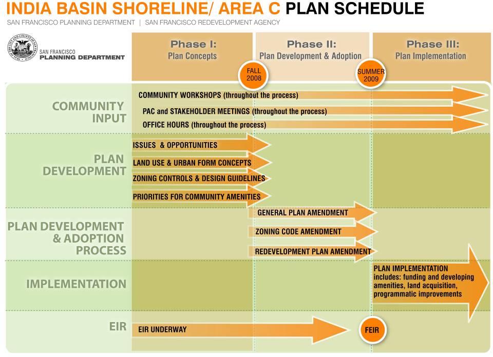
India Basin/Hunters Point Shoreline Community Workshop May 21, 2008
|
|
|
- Griffin Watkins
- 5 years ago
- Views:
Transcription

1 India Basin/Hunters Point Shoreline Community Workshop May 21, 2008


2 Workshop Agenda Welcome Process Overview Context & Existing Conditions Presentation of Draft Concepts Land Use and Open Space Priorities Circulation Building Scale Small Group Discussion Group Report Backs Q & A Next Steps

3 Study Area Hunters Point Shoreline Area, also known as India Basin Shoreline Neighborhood, also known as. BVHP Survey Area C
4 Goals of the Planning Process Implement the 2002 Bayview Hunters Point Community Revitalization Concept Plan Create a cohesive plan, including land use regulations and design standards, that enhances the neighborhood and shoreline Prioritize community benefits and services Amend the Bayview Hunters Point Redevelopment Plan
5 Vision for India Basin Mixed-use neighborhood Development that is compatible with context and character Build on the unique shoreline location, Ensure significant access and open space amenities Walkable community Plan Components Land Use Form Amenities
6 Plan Components How to Realize Vision 1. Amendment to the General Plan: BVHP Area Plan Policy framework, reflects the big picture vision for India Basin and establishes the guiding framework Land use diagram, circulation framework, open space priorities 2. Zoning controls and design guidelines Tools to achieve the type and quality of development envisioned in India Basin Guide and review future development proposals on private land Guide public realm improvements in the Plan Area 3. Redevelopment Plan Amendment Implement India Basin s prioritized improvements and amenities Guide future decisions about funding and resources, land acquisition, negotiations with property owners


7 Where We ve Been Workshop #1: August 2007 Reviewed planning objectives Identified of key issues, areas of consensus, competing ideas Workshop #2: October 2008 Refined objectives Discussed 3 land use alternatives Community Meeting: January 2008 Overview of all BVHP planning efforts and development projects Context for change

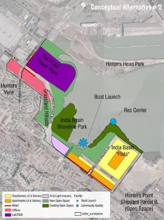
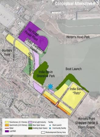
8 Where We ve Been 3 Alternatives (October, 2007)


9 Where We ve Been BVHP PAC input on process and issues Stakeholder meetings Office Hours Existing conditions analysis and context studies
10 Where are we now? Tonight: Discuss draft land use concept and urban form proposals Land Use Concept Open Space Priority Zones Circulation Concept Building Scale Concept Build off of areas of consensus Answer key questions Tonight s work will inform: Plan development Future zoning districts, development controls, design guidelines Implementation priorities
11
12 Understanding and Learning From the Context
13 Planning Context Policy Direction Existing Conditions Surrounding Plans and Proposals
 Hunters Point Shipyard")
14 India Basin Industrial Park Heron s Head Park Hunters View (SFHA) India Basin Northridge Westbrook (SFHA) Hunters Point Shipyard Parcel B

15 Context: Community Revitalization Concept Plan

16 Context: General Plan Direction Bayview Hunters Point Area Plan
 Priority maintaining significant public access to the shoreline Port of San Francisco Waterfront Land Use Plan Contains general guidelines and policies regarding waterfront")
17 Context: Other Plans and Policies BCDC (Bay Conservation and Development Commission) Plans and Policies Review and regulate projects within100 shoreline buffer (from mean high tide line) Priority maintaining significant public access to the shoreline Port of San Francisco Waterfront Land Use Plan Contains general guidelines and policies regarding waterfront planning

18 Context: Existing Zoning P M-2 M-1 NC-2

19 Context: Interim Zoning Controls Adopted 2006 Applies to both NC and M zoned parcels Conditional Use approval required for change of use or new construction Interim controls expire in June, 2009
20 Context: Existing Height Districts 40 ft. OS

21 Context: Topography Topography in the area affects walkability Focus on creating pedestrian connections and accessible land uses, taking topo into account Third Street


22 Context: Block Pattern India Basin: Undefined and Irregular Block Pattern, lack of a street grid More traditional Bayview grid pattern

23 Context: Ownership Patterns Private Public

24 Context: Open Space Patterns Wide range of open space uses Active Passive Potential opportunities for improving existing open space Gap in the Bay Trail Limits access Closing the gap will improve connectivity Existing trail ROW, opportunities for improvements Bay Trail Gap Heron s Head primarily passive recreation Active recreation Existing OS, opportunity for improvements Planned future park


25 Context: Historic Character India Basin is an older part of San Francisco 900 Innes recent landmarking Future planning and design will take into account historic character of the community

")


26 Context: Surrounding Plans and Proposals Hunters Point Shipyard, Phase 1: Hunters View: Phase 1: 280 units, late 2011 Phase 2: 260 units, 2013 Phase 3: 260 units, 2015 (approx 800 units total; includes replacement of 267 units) Approx units, 40 ac open space construction begins in 2009, completed in 2012 or 2013 Hunters Point Shipyard/Candlestick Point Phase 2: Up to 10,000 units 2,000,000 sf commercial New stadium 400 ac open space/rec 3 phases, over a 20 year development timeline

27 Context: Asset Mapping
28 Planning Concepts
29 4 Concept Maps for Discussion Land Use Recreation and Open Space Priority Zones Circulation Building Scale working together to form the basis of the India Basin Plan


30 Map #1: Land Use Concept Key Elements Create a neighborhood, destination and sense of place Take advantage of the location emphasize the shoreline and India Basin s unique qualities Ensure flexibility and focus on form Emphasize creative land uses think outside of the box in terms of uses, and mix
31


32 Emerging Technologies Employment District Land Uses: Innovative Job Center Conference Center, Visitor Attraction, Hotel Retail to complement employment uses Open Space and Rec. activities
33 Emerging Technologies Employment District


34 Hillside Hillside Transition Transition District District Land Uses: Residential Neighborhood services, retail and/or office Open space and rec. uses Passive Community garden Interpretive center
35 Hillside Transition District


36 Maritime Neighborhood Center District Land Uses: Neighborhood-serving retail/residential above Recreation and shoreline activities Cultural/community serving use Arts and limited light industry
37 Maritime Neighborhood Center District


38 Innovative Mixed-Use District Commercial office Creative industries Industrial & R&D Variety of residential types Neighborhoodserving retail and services Hotel/visitor serving use Open space and rec.

39 Innovative Mixed Use District


40 Shoreline Recreation Access Zone Improvements & Amenities: Public shoreline protection and access Maintain and improve existing rec. and open space areas Complete the Bay Trail Future open space and rec. opportunity sites
41 Shoreline Recreation Access Zone
42


43 Map #2: Recreation & Open Space Priority Zones Overlay to the land use concept Open space is an important aspect of each district each contains a priority zone Specific location, acquisition strategy, and programming will be determined through plan implementation
44


45 Map #3: Circulation Concept - Principles Promote walkability, access, and connections to the shoreline. Create connections within India Basin, and to adjacent neighborhoods and amenities. Improve existing rights-of-way Focus on key intersection improvements Conceptual ideas to spur discussion
46


47 Map #4: Building Scale Concept - Principles Building heights should step down towards the water to protect public views of the water and encourage shoreline access; Heights should be varied to avoid monolithic walls of development Taller buildings can be located at strategic locations, to help create visual and physical focus within India Basin.
48
49 Small Group Discussions
50 Small Group Discussions Please discuss key questions about maps Land Use Open Space Priorities Circulation Building Scale Note areas of agreement and/or disagreement on the large base maps Report back on key points for each of the discussion topics
51 Questions & Answers and Next Steps
52 Next Steps Ongoing outreach through BVHP PAC Office hours July 2008 Public Workshop #4 Fall 2008 Refined concepts Design standards and guidelines Implementation Strategies
53 Next Steps Develop General Plan Amendment framework Refine land use concept Explore preliminary zoning categories Create design guidelines and development standards Prepare for the Redevelopment Plan Amendment Amenities costing and prioritization Analyzing financial mechanisms (Tax Increment Financing) Continued coordination with Hunters Point Shipyard/Candlestick Point project
54 Additional Questions or Comments Please call or Adena Friedman, San Francisco Planning Department Kelley Kahn, San Francisco Redevelopment Agency
55 Thank you very much for participating!
56 India Basin/Hunters Point Shoreline Community Workshop May 21, 2008
Coliseum Station Area Area Redevelopment Plan. Public Engagement #1 June 12, 2017
 Coliseum Station Area Area Redevelopment Plan Public Engagement #1 June 12, 2017 Welcome Engagement Purpose Introduce the project Share information Gather input Project Updates & Newsletter edmonton.ca/coliseumplan
Lynn Waterfront Master Plan
 Lynn Waterfront Master Plan Public Meeting #2 December 10th, 2018 1 Project Schedule Update September 26, 2018 December 10, 2018 Development of the Master Harbor Plan Amendment and Revised Waterfront Master
PLAN ELEMENTS WORKSHOP. April 5, 2016
 PLAN ELEMENTS WORKSHOP April 5, 2016 needs more housing. But there is no one-size fits-all solution. Every neighborhood has its own character. In some places, density is not only appropriate it is badly
DRAFT PLAN PRESENTATION
 DRAFT PLAN PRESENTATION 1.23.2018 AGENDA Process Project Schedule Results from Visioning Workshop Draft Plan Highlights Concept Plans Feedback Next Steps PROJECT SCHEDULE KICK-OFF WORKSHOP August 29 th
Rio/29 Small Area Plan. Design Plan & Implementation Framework Open House - January 25, 2018
 Rio/29 Small Area Plan Design Plan & Implementation Framework Open House - January 25, 2018 MEETING PURPOSE PRESENTATION 1. Orient to the updated design plans 2. Introduce implementing options 3. Explain
JANUARY 19, 2011 CENTRAL AVENUE-METRO BLUE LINE TRANSIT-ORIENTED DEVELOPMENT IMPLEMENTATION PROJECT COMMUNITY FORUM
 CENTRAL AVENUE-METRO BLUE LINE TRANSIT-ORIENTED DEVELOPMENT IMPLEMENTATION PROJECT COMMUNITY FORUM JANUARY 19, 2011 THE MARYLAND-NATIONAL CAPITAL PARK AND PLANNING COMMISSION PRINCE GEORGE S COUNTY PLANNING
CENTRAL ESTUARY PLAN AVISION FOR OAKLAND S WATERFRONT
 Central Estuary Plan A VISION FOR OAKLAND S WATERFRONT Specific Plan and Environmental Assessment Presentation to the Parks and Recreation Advisory Commission December 9, 2009 This Afternoon s Presentation
PORT OF SAN FRANCISCO
 PORT OF SAN FRANCISCO WATERFRONT LAND USE PLAN Prop H (1990) required a Waterfront Land Use Plan Port property in BCDC jurisdiction Define Acceptable Uses Hotels prohibited on piers Prioritize Maritime
WAC #7 3/14/14. Coachella General Plan Update
 WAC #7 3/14/14 Coachella General Plan Update Agenda 2 Introductions Public Draft General Plan Overview and Discussion of Next Steps Implementation and Evaluation Health Element Process Evaluation (discussion)
Scope of Services. River Oaks Boulevard (SH 183) Corridor Master Plan
 Corridor Master Plan") Scope of Services River Oaks Boulevard (SH 183) Corridor Master Plan PROJECT AREA The project area consists of the River Oaks Boulevard (SH 183) corridor bounded by SH 199 at the northern end and the Trinity
Scope of Services River Oaks Boulevard (SH 183) Corridor Master Plan PROJECT AREA The project area consists of the River Oaks Boulevard (SH 183) corridor bounded by SH 199 at the northern end and the Trinity
Small Area Plan. South Gateway
 Small Area Plan Adopted May 12, 2008 South Gateway Purpose. The South Gateway Small Area Plan defines the City s expectations for the future of the southern entrance to the City at Interstate 85 and Highway
Philip A. Ginsburg, General Manager Dawn Kamalanathan, Director, Planning and Capital Projects
 Date August 5, 2015 To: Through: From: Subject: Recreation and Park Commission Capital Committee Philip A. Ginsburg, General Manager Dawn Kamalanathan, Director, Planning and Capital Projects Nicole Avril,
Chapter 1.0 Introduction
 Chapter 1.0 Introduction 1.1 Background The North Metro commuter rail line is part of the RTD FasTracks regional transit system expansion program to build more than 100 miles of rail transit throughout
Town of Cobourg Heritage Master Plan. Statutory Public Meeting
 Town of Cobourg Heritage Master Plan Statutory Public Meeting April 25 th 2016 Presentation Overview 1. Introduction 2. Project background and schedule overview 3. Review of strategic direction content
DOMINION BOULEVARD CORRIDOR STUDY AND ECONOMIC DEVELOPMENT STRATEGIC PLAN A MODEL FOR CHESAPEAKE S FUTURE
 DOMINION BOULEVARD CORRIDOR STUDY AND ECONOMIC DEVELOPMENT STRATEGIC PLAN A MODEL FOR CHESAPEAKE S FUTURE Overview I. Draft Plan Process II. Draft Plan Overview a. Market Analysis b. Master Land Use Plan
Workshop 3. City of Burlington Waterfront Hotel Planning Study. September 14, The Planning Partnership
 Workshop 3 City of Burlington Waterfront Hotel Planning Study September 14, 2017 The Planning Partnership The Waterfront Hotel Planning Study 01 The Brant & Lakeshore Planning Study will establish a Strategic
THE TOWN OF WASAGA BEACH
 THE TOWN OF WASAGA BEACH Downtown Development Master Plan Committee of the Whole Presentation January 26 th 2017 Uses within this designation should reflect a dependence on tourism as opposed to the permanent
PORT OF VANCOUVER WATERFRONT DEVELOPMENT. Concept Development Plan City Center Redevelopment Authority April 20, 2017
 PORT OF VANCOUVER WATERFRONT DEVELOPMENT Concept Development Plan City Center Redevelopment Authority April 20, 2017 Port History PORT ESTABLISHED 1912 TERMINAL 1 ACQUIRED 1925 GWM SIGNS LEASE 1935 HARBOR
UCSF Parnassus Heights Re-Envisioning Process
 UCSF Parnassus Heights Re-Envisioning Process Community Working Group Meeting #5 February 27, 2019 Agenda Welcome, Introductions, Agenda Overview, and Review of Last Meeting Summary of Community Ideas
FUNDING CORRIDOR REVITALIZATION
 FUNDING CORRIDOR REVITALIZATION Integrated corridor planning for the 21 st Century America Planning Association Annual Conference Atlanta, GA April 27, 2014 Mariia Zimmerman, MZ Strategies, LLC mariia@mzstrategies.com
Tonight s Agenda. Summary Presentation Open House. Group Discussion Next Steps: online community wide survey
 Community Open House February 22, 2018 Tonight s Agenda Summary Presentation Open House Station 1: Project Overview and Community Input Station 2: Draft Vision and Guiding Principles Station 3: Western,
Streets for People, Place-Making and Prosperity. #TOcompletestreets
 COMPLETE STREETS FOR TORONTO Streets for People, Place-Making and Prosperity COMPLETE STREETS: A NEW APPROACH A Complete Streets design approach considers the needs of all users people who walk, bicycle,
Port Lavaca Future Land Use
 Port Lavaca Future Land Use Introduction The City of Port Lavaca is beginning to see sustained growth, after many years of relative stable population. New single family homes, apartments, and businesses
Route 1 Corridor Study
 Route 1 Corridor Study Westbrook, Connecticut A Vision for the Connecticut Shoreline Public Informational Meeting July 28, 2015 Lower Connecticut River Valley Council of Governments Fitzgerald & Halliday,
{Best Practices. Summary of Tools, Strategies and Best Practices from 11 Michigan Case Study Communities
 Case Studies Michigan Coastal Community Working Waterfronts { Summary of Tools, Strategies and from 11 Michigan Case Study Communities Table of Contents Zoning...2 Community and Stakeholder Collaboration
General Plan Infill Policies (workshops and hearings)
") COMMUNITY PROCESS General Plan Infill Policies (workshops and hearings) Stockton Greater Downtown Housing Strategy (2007-2008) Housing Action Team Property owner meetings Community workshop Planning Commission
COMMUNITY PROCESS General Plan Infill Policies (workshops and hearings) Stockton Greater Downtown Housing Strategy (2007-2008) Housing Action Team Property owner meetings Community workshop Planning Commission
Don Mills Crossing Study and Celestica Lands Development Application Community Meeting, Open House, and Breakout Discussions
 Consultation Summary Don Mills Crossing Study and Celestica Lands Development Application Community Meeting, Open House, and Breakout Discussions This report is not intended to provide a verbatim transcript
2035 General Plan Update and Belmont Village Specific Plan. Joint Study Session with the City Council and Planning Commission April 12, 2016
 2035 General Plan Update and Belmont Village Specific Plan Joint Study with the City Council and Planning Commission April 12, 2016 Agenda 1. Welcome and Introductions 2. General Plan Update Status of
Building Great Neighbourhoods. Strathcona
 Building Great Neighbourhoods Strathcona March 21, 2018 Becky Redford Project Manager, Planning & Design Building Great Neighbourhoods Integrated Infrastructure Services Welcome and Purpose To provide
Summary Community Workshop #1 Fruitvale San Antonio Senior Center Monday, March 23, :00-9:00 p.m.
 Summary Community Workshop #1 Fruitvale San Antonio Senior Center Monday, March 23, 2009 7:00-9:00 p.m. Workshop Format and Process The City of Oakland is preparing a Specific Plan that will help define
Envision Concord Public Event Part 1 October 21, :30 AM 12:00 PM Concord-Carlisle High School Cafeteria
 Envision Concord Public Event October 21, 2017 9:30 AM 12:00 PM Concord-Carlisle High School Cafeteria Good Morning! Welcome & Introduction Gary Kleiman & Elise Woodward, Envision Concord Committee Co-Chairs
RE-Imagining the Downtown Colorado Springs Master Plan
 RE-Imagining the Downtown Colorado Springs Master Plan 2016 APA Colorado State Conference October 25, 2016 Overview 8:00 Welcome, Introductions, and Overview 8:15 Downtown s Planning History 8:30 A Market
Robbinsdale LRT Station. CDI Development Guidelines. August Overview
 Robbinsdale LRT Station August 2018 Overview The City of Robbinsdale may have the coolest opportunity site along the 13 mile stretch of the Bottineau LRT corridor / Blue Line extension. Located a block
Welcome to the Oakridge Centre Open House
 Welcome to the Oakridge Centre Open House Why is the City hosting this event? This open house is to inform you of a rezoning application submitted to the City of Vancouver to amend the existing CD-1 (Comprehensive
SAN RAFAEL GENERAL PLAN 2040 INTRODUCTION AND OVERVIEW
 SAN RAFAEL GENERAL PLAN 2040 INTRODUCTION AND OVERVIEW Steering Committee Presentation February 14, 2018 Purpose of General Plan Guide land use and development decisions Coordinate transportation, infrastructure,
ROBBINSDALE LRT STATION CDI DEVELOPMENT GUIDELINES
 August 2018 OVERVIEW The City of Robbinsdale has a prime-opportunity site in the middle of the 13 mile stretch of the Bottineau LRT corridor / Blue Line extension. Robbinsdale offers a prominent, vital,
Delaware River Waterfront Corporation
 Delaware River Waterfront Corporation Delaware River Waterfront Corporation Created in January 2009 to replace Penn s Landing Corporation o Open, accountable, effective leadership o New Board of Directors
3. VISION AND GOALS. Vision Statement. Goals, Objectives and Policies
 Vision Statement Queen Creek s interconnected network of parks, trails, open spaces and recreation opportunities provide safe and diverse activities and programs that sustain its unique, small town, equestrian
Pier 70 Master Plan. Port of San Francisco
 Project Overview Develop a Preferred Master Plan for a 65-acre Brownfield site Adaptive reuse of historic structures and new development that reconciles numerous regulatory, economic, maritime, historic
DESIGN WORKSHOP. November 17, 2015
 DESIGN WORKSHOP November 17, 2015 needs more housing. But there is no one-size fits-all solution. Every neighborhood has its own character. In some places, density is not only appropriate it is badly -
Sustainability, Health, Safety, Recreation & Open Space Working Group August 3, 2017
 Sustainability, Health, Safety, Recreation & Open Space Working Group August 3, 2017 DOWNTOWN OAKLAND SPECIFIC PLAN WELCOME Sustainability, Health, Safety, Recreation & Open Space Working Group Social
Atlanta BeltLine Subarea 3 Master Plan Update
 Atlanta BeltLine Subarea 3 Master Plan Update April 14, 2018 Workshop Meeting 1 22 miles, connecting 45 neighborhoods 22 MILES of transit 46 MILES of streetscapes and complete streets 33 MILES of urban
Welcome. Walk Around. Talk to Us. Write Down Your Comments
 Welcome This is an information meeting introducing the applications for proposed redevelopment of the Yorkdale Shopping Centre site at 3401 Dufferin Street and 1 Yorkdale Road over the next 20+ years,
Natomas Vision Plan and PLNP
 Natomas Vision Plan 20030171 and PLNP2014-00172 Department of Community Development Planning and Environmental Review Leighann Moffitt Sub-Agenda 1. Staff Presentation Leighann Moffitt, County Planning
Staff Report and Recommendation
 Community Planning and Development Planning Services 201 W. Colfax Ave., Dept. 205 Denver, CO 80202 p: 720.865.2915 f: 720.865.3052 www.denvergov.org/cpd TO: City Council Neighborhoods and Planning Committee
Streets, Connectivity & Built Environment Working Group August 2, 2017
 Streets, Connectivity & Built Environment Working Group August 2, 2017 DOWNTOWN OAKLAND SPECIFIC PLAN WELCOME Streets, Connectivity & Built Environment Working Group Social Equity Meeting August 2, 2017
DALY CITY VISIONING PROCESS COMMUNITY WORKSHOP 3 MAY 8, 2008
 DALY CITY VISIONING PROCESS COMMUNITY WORKSHOP 3 MAY 8, 2008 PROCESS General Plan - a statement of the community s values, vision and aspirations for now and into the future... Timeframe LONG TERM - 2030
In surveys, Dallas residents say what they want to change most
 NEIGHBORHOODS ELEMENT In surveys, Dallas residents say what they want to change most in the city is its appearance they want it to look beautiful, with trees and pedestrian-friendly neighborhoods. The
Implementation Guide Comprehensive Plan City of Allen
 Implementation Guide 2030 Comprehensive Plan City of Allen DRAFT 2015 Implementation Guide Allen 2030 Comprehensive Plan INTRODUCTION The Comprehensive Plan serves as a guide for the growth and development
M i s s i o n B a y W a t e r f r o n t
 114 M i s s i o n B a y W a t e r f r o n t Character of the Area: The Mission Bay Waterfront extends from Pier 48 at China Basin Channel to 18th Street in the Central Basin. This area of the waterfront
WELCOME and introduction
 1 WELCOME and introduction Mobility Hub Locations within Burlington STUDY OVERVIEW STUDY OBJECTIVES The City of Burlington is developing four Area Specific Plans, one for each of Burlington s Mobility
University of Saskatchewan CAMPUS MASTER PLAN. Senate Meeting Preliminary Presentation. April 21, 2018 DIALOG ECS DA WATT
 University of Saskatchewan CAMPUS MASTER PLAN Senate Meeting Preliminary Presentation April 21, 2018 DIALOG ECS DA WATT project process presentation agenda Stakeholder Engagement Project Control phase1
NORTH CLAYMONT AREA MASTER PLAN COMMUNITY WORKSHOP #1 FEBRUARY 3, 2016
 NORTH CLAYMONT AREA MASTER PLAN COMMUNITY WORKSHOP #1 FEBRUARY 3, 2016 1. Introduction To the team and to the Plan Planning Partners The Claymont Community WILMAPCO New Castle County Claymont Renaissance
WARM SPRINGS PARK MASTER PLAN
 TABLE OF CONTENTS page 1.0 Introduction and Overview 1 2.0 Information Gathering 2 3.0 Conceptual Alternative Development 8 4.0 Master Plan Development 14 5.0 Construction Cost Estimates 19 LIST OF FIGURES
The Five Components of the McLoughlin Area Plan
 The Five Components of the McLoughlin Area Plan This documents contains the complete language of the five components of the McLoughlin Area Plan: The Vision Statement The Values The Guiding Principles
FOUR MILE RUN VALLEY WORKING GROUP AND CHARGE
 FOUR MILE RUN VALLEY WORKING GROUP AND CHARGE Adopted April 16, 2016 Amended July 19, 2016 Overview of Integrated Effort The overall goal of the Four Mile Run Valley (4MRV) initiative is to develop a comprehensive
planning toronto s downtown Parks and Public Realm Plan Request for Proposals Information Meeting Andrew Farncombe, Project Manager August 19, 2015
 planning toronto s downtown Parks and Public Realm Plan Request for Proposals Information Meeting Andrew Farncombe, Project Manager August 19, 2015 BATHURST ST Keeping Downtown a great place to live, work,
STUDY AREA. Tonight s Agenda. Project Tasks Completed. Next Steps. Town of Oyster Bay Eastern Waterfront Community Vision & Revitalization Plan
 Town of Oyster Bay Eastern Waterfront Community Vision & Revitalization Plan Public Meeting January 27, 2009 Opening Remarks Presentation Tonight s Agenda Introduction Study Area Overview Public Participation
City of Farmington. Downtown Plan. Amendment to the 1998 Master Plan Adopted October 11, 2004
 City of Farmington Amendment to the 1998 Master Plan Adopted October 11, 2004 Introduction Planning Background 1 Scope and Components of the Plan Amendment 2 Concept Introduction 3 Plan Concepts 3 Conceptual
Rezoning Issues Setting a Foundation for Zoning Decisions
 Rezoning Issues Setting a Foundation for Zoning Decisions City Council Workshop May 2, 2016 Agenda Goal Need actionable items and sequence of steps Foundation for Zoning Decisions Council Workshop Discussion
We are a determined group residents, industry, and government and by working together an incredible future lies ahead for Troy.
 PROPOSED EDITS TO COMPREHENSIVE PLAN April 5, 2018 Page Par Change Iv TOC Principle 2, page number is 3 should be 33 I Forward Par 3, delete Strike through: Troy is today experiencing 3 1.1 Par 3 change
REVIEW AND EVALUATION OF REGIONAL LAND USE
 REVIEW AND EVALUATION OF REGIONAL LAND USE AND TRANSPORTATION SCENARIOS #220831 Environmental Justice Task Force October 7, 2014 VISION 2050 Process Development of Guiding Vision for Land Use and Transportation
Town Center (part of the Comprehensive Plan)
") Town Center (part of the Comprehensive Plan) Mercer Island Town Center Looking North (2014) In 1994, a year-long process culminated in a set of design guidelines and code requirements for the Town Center
Town Center (part of the Comprehensive Plan) Mercer Island Town Center Looking North (2014) In 1994, a year-long process culminated in a set of design guidelines and code requirements for the Town Center
City of Missoula and Missoula County Open Space Planning Open House
 City of Missoula and Missoula County Open Space Planning Open House FEBRUARY 6, 2018 The following slides contain the display board content from the open house. Please use boards to answer questions in
M E M O R A N D U M. DATE: July 19, Patrick D. O Keeffe, City Manager. Economic Development & Housing
 M E M O R A N D U M DATE: July 19, 2011 TO: FROM: Patrick D. O Keeffe, City Manager Economic Development & Housing SUBJECT: Resolution of the City Council of the City of Emeryville Approving the Application
San Francisco Recreation and Park Commission Capital Committee
 Date March 7, 2018 To: Through: From: Subject: San Francisco Recreation and Park Commission Capital Committee Philip A. Ginsburg, General Manager Nicole Avril, Project Director, Capital Partnerships India
SUBJECT: Waterfront Hotel Planning Study Update TO: Planning and Development Committee FROM: Department of City Building. Recommendation: Purpose:
 Page 1 of Report PB-23-18 SUBJECT: Waterfront Hotel Planning Study Update TO: Planning and Development Committee FROM: Department of City Building Report Number: PB-23-18 Wards Affected: 2 File Numbers:
WEST OAKLAND SPECIFIC PLAN & DRAFT ENVIRONMENTAL IMPACT REPORT
 WEST OAKLAND SPECIFIC PLAN & DRAFT ENVIRONMENTAL IMPACT REPORT Landmarks Preservation Advisory Board Public Hearing February 10, 2014 1 Specific Plan Overview Plan Area is generally bounded by I-580 to
CITY CLERK. Parkland Acquisition Strategic Directions Report (All Wards)
") CITY CLERK Clause embodied in Report No. 10 of the, as adopted by the Council of the City of Toronto at its meeting held on November 6, 7 and 8, 2001. 10 Parkland Acquisition Strategic Directions Report
CITY CLERK Clause embodied in Report No. 10 of the, as adopted by the Council of the City of Toronto at its meeting held on November 6, 7 and 8, 2001. 10 Parkland Acquisition Strategic Directions Report
Fisherman s Wharf Public Realm Plan
 Fisherman s Wharf Public Realm Plan SPUR Presentation July 11, 2008 3 February 2010 WHY A PUBLIC REALM PLAN? Public Life 1900 1950 1965 2000 Mainstreet Copenhagen in 100 years From nessesary to optional
Public Open House #1
 Public Open House #1 TONIGHT S AGENDA Welcome Project Overview The Big Picture The Station Area The Analysis Thoughts about Future Change Breakout Group Discussions Summation / Next Steps Project Overview
Making Transit Oriented Development Work For Boonton, NJ
 Making Transit Oriented Development Work For Boonton, NJ Bloustein School of Planning and Public Policy Studio Dan Burton Loannie Dao Webster Slater Brandon Williams Ian Watson Maria Laham Nicola Mammes
Atlanta BeltLine. Subareas 9 & 10. Master Plan Updates. March 26, Washington Park Jamboree 1
 Atlanta BeltLine Subareas 9 & 10 Master Plan Updates March 26, 2018 Washington Park Jamboree 1 22 miles, connecting 45 neighborhoods 22 MILES of transit 46 MILES of streetscapes and complete streets 33
Whitemarsh Comprehensive Plan Update: Housing & Land Use. Public Workshop #3: September 20, 2018
 Whitemarsh Comprehensive Plan Update: Housing & Land Use Public Workshop #3: September 20, 2018 Agenda Welcome Process Recap What We ve Heard The Plan Framework Review of Recommended Actions Land Use Housing
PRINCE GEORGE S PLAZA TRANSIT DISTRICT DEVELOPMENT PLAN AND TRANSIT DISTRICT OVERLAY ZONE UPDATE
 PRINCE GEORGE S PLAZA TRANSIT DISTRICT DEVELOPMENT PLAN AND TRANSIT DISTRICT OVERLAY ZONE UPDATE UNIVERSITY PARK TOWN LISTENING SESSION JUNE 12, 2014 Prince George s County Planning Department The Maryland-National
Public Open House. Overview of the Downtown Plan Official Plan Amendment April 23, 2018
 Public Open House Overview of the Downtown Plan Official Plan Amendment April 23, 2018 1 A 25-Year Plan for Downtown To ensure growth contributes positively to Toronto s Downtown as a great place to live,
José Campos Manager of Planning and Design Review SPUR San José Symposium October 12, 2018
 1 Transbay: Freeways to New Ways José Campos Manager of Planning and Design Review SPUR San José Symposium October 12, 2018 2 Transbay freeway land pre-1989 3 1989 Loma Prieta Earthquake 4 TRANSBAY c.
It Takes A Village.. Preserving Rural Character In Standish
 It Takes A Village.. Preserving Rural Character In Standish A Public Workshop Hosted by Conservation and Open Space Plan Committee & Standish Corner Village Implementation Committee June 12, 2008 Desired
Beaverton City Council: Work Session. SIDEDistrict. May 6, 2014
 BEAVERTON Beaverton City Council: CREEK Work Session SIDEDistrict May 6, 2014 Tonight s Agenda BEAVERTON CREEK SIDE Brief updates Creekside Vision Scenarios & discussion: Redevelopment & Parking Project
City Center Neighborhood Plan
 [1] City Center Neighborhood Plan As adopted by Ordinance No. 2014-09-049 and amended by Ordinance Nos. Formerly CBD Neighborhood as adopted by Ordinance No. 8868 and amended by Ordinance Nos. 8946, 9693,
Informational Presentation JULIE CHRISTIENSEN DP-NWP GBD 29 JUNE 2016
 Informational Presentation JULIE CHRISTIENSEN DP-NWP GBD 29 JUNE 2016 TODAY S TOPICS 1. Public Realm Plan Goals & Outcomes 2. Project Identification & Polling 3. Current Capital Projects 4. Early Implementation
Blueprint Denver Task Force Meeting #
 Blueprint Denver Task Force Meeting #1 6.23.16 1. Welcome and Introductions Your name and affiliation Name 1 thing you love about Denver Name 1 thing you d change about Denver All in 30 seconds! Ready,
hermitage town center
 hermitage town center A Community Vision prepared by Strada for The City of Hermitage and The Mercer County Regional Planning Commission January 2007 table of contents introduction 3 design principles
City of Tacoma Planning and Development Services
 Agenda Item E-1 City of Tacoma Planning and Development Services To: Planning Commission From: Elliott Barnett, Planning Services Division Subject: Tacoma Mall Regional Center Subarea Plan and EIS Meeting
CITY OF PUYALLUP. Background. Development Services
 CITY OF PUYALLUP Development Services 333 South Meridian Puyallup WA 98371 To: City Council From: Katie Baker, AICP, Planning Division Re: South Hill Neighborhood Plan Adoption Date: (Meeting date: February
Getting and Giving the Most
 Getting and Giving the Most It s OUR meeting participate enthusiastically Focus on the future Terminology expertise is secondary There is such a thing as a bad idea! Respect (for each other and the process)
City of Heath. Town Center Concept
 In the give-and-take of getting projects designed, financed, and approved, the famous refrain from the film Field of Dreams is heard often: if you build it, they will come. From the perspective of the
A BLUEPRINT FOR BROCKTON A CITY-WIDE COMPREHENSIVE PLAN
 A BLUEPRINT FOR BROCKTON A CITY-WIDE COMPREHENSIVE PLAN Public Meeting October 2016 1 Plan Summary and Discussion Public Meeting May 4 2017 City of Brockton Bill Carpenter, Mayor Department of Planning
Public may provide comments on the GDP within the next two weeks (December 24)
") 25/70 General Development Plan (GDP) Public Meeting Wednesday, December 10, 2014 6:00 8:00 P.M. District 1 Police Station Community Room 1311 W 46th Ave, Denver, CO 80211 Council Woman Montero: This particular
25/70 General Development Plan (GDP) Public Meeting Wednesday, December 10, 2014 6:00 8:00 P.M. District 1 Police Station Community Room 1311 W 46th Ave, Denver, CO 80211 Council Woman Montero: This particular
ALLEN CREEK GREENWAY. Citizens Advisory Committee Meeting #5 July 19, Allen Creek Greenway Master Plan. July 2017
 1 ALLEN CREEK GREENWAY MASTER PLAN Citizens Advisory Committee Meeting #5 July 19, 2017 Agenda 2 Final DRAFT Preferred Plan (30 min) Master Plan Document Outline (5 min) Potential Implementation Strategy
Old Town Neighborhoods Plan. Choices Event Wednesday, December 9, 2015
 Old Town Neighborhoods Plan Choices Event Wednesday, December 9, 2015 Agenda 6:00 6:10 p.m. Welcome + Sign In 6:10 6:30 p.m. Presentation 6:30 8:00 p.m. Workshop + Open House Seeking your input on: Neighborhood
Endorse the Alameda Point Conceptual Planning Guide
 CITY OF ALAMEDA Memorandum To: From: Honorable Mayor and Members of the City Council John A. Russo City Manager Date: July 23,2013 Re: Endorse the Alameda Point Conceptual Planning Guide BACKGROUND The
12 th Street Connector Alignment Study VISIONING PUBLIC WORKSHOP - JUNE 25, :00PM TO 8:00PM
 12 th Street Connector Alignment Study VISIONING PUBLIC WORKSHOP - JUNE 25, 2018 6:00PM TO 8:00PM Goals for Today s Workshop Agenda: Project Introduction, Purpose, and Goals Existing Conditions Traffic
CITY OF CHARLOTTESVILLE, VIRGINIA CITY COUNCIL AGENDA
 CITY OF CHARLOTTESVILLE, VIRGINIA CITY COUNCIL AGENDA Agenda Date: December 16, 2013 Action Required: Adoption of Resolution Presenter: Staff Contacts: Title: James E. Tolbert, AICP, Director of NDS James
INTEGRATING FAST FERRY SERVICE IN WOODBRIDGE
 INTEGRATING FAST FERRY SERVICE IN WOODBRIDGE TECHNICAL ASSISTANCE PANEL DECEMBER 12, 2018 MONTH DATE YEAR Urban Land Institute The mission of the Urban Land Institute is to provide leadership in the responsible
Anatomy of A Vibrant Downtown. Anatomy of a Vibrant Downtown
 Anatomy of A Vibrant Downtown The goal of MAIN ST. REVITALIZATION PLANNING is to provide a framework that will help transform your downtown into a VIBRANT DOWNTOWN a place where people love to LIVE, WORK,
Proposed Downtown Plan
 Proposed Downtown Plan Harbord Village Residents Association AGM October 18, 2017 Timeline Implementation The Role of Downtown Employment Growth Downtown 432,900 jobs 502,100 jobs 850,000-915,000 jobs
South of Eastern Strategic Direction Status Update
 STAFF REPORT ACTION REQUIRED South of Eastern Strategic Direction Status Update Date: July 10, 2014 To: From: Planning and Growth Management Committee Chief Planner and Executive Director, City Planning
Mississippi Drive Corridor Revitalization. A DestinationTransportation Project...
 Mississippi Drive Corridor Revitalization A DestinationTransportation Project... Mississippi Drive Corridor Revitalization Welcome! Tonight s Agenda: Further define the Scope of the Project Discuss the
of ZONING OVERHAUL
 City City of Somerville of ZONING OVERHAUL www.somervillezoning.com November 27, 2018 TONIGHT S AGENDA 1. Recreational Marijuana 2. Answering Alderman questions 1. Mapped Densities Across Somerville Mapped