Evaluating Low Impact Development Practices for Stormwater Management on an Industrial Site in Mississippi
|
|
|
- Adele Manning
- 5 years ago
- Views:
Transcription
1 Evaluating Low Impact Development Practices for Stormwater Management on an Industrial Site in Mississippi Dennis S. Painter, Tennessee Valley Authority, Nashville, Tennessee Donald Becker, Tennessee Valley Authority, Nashville, Tennessee Avinash S. Patwardhan, CH2M HILL, West Palm Beach, Florida Thomas Jobes, CH2M HILL, Atlanta, Georgia Patrick Graham, CH2M HILL, Vancouver, Canada Keywords: Low Impact Development, Sustainable Development, Pollution Prevention, Green Building, Best Management Practices, Stormwater Retrofit, Bioretention, Rainwater Capture, Nonpoint Source Pollution. Abstract Industrial site development can result in substantial impacts to water quality and quantity. While permitting requirements may reduce impacts, they are limited in addressing longterm cumulative and operational impacts from the changes in land uses and cover. Many of these developments occur within watersheds containing impaired waters across the Southeast. Approximately 25,000 acres of industrial sites are developed or expanded each year in the 201-county Tennessee Valley Authority (TVA) power service region. TVA s mission is to promote sustainable economic development, energy production, and environmental stewardship. This paper describes methodologies used to perform stormwater evaluations at a TVA facility, including hydrologic and water quality modeling. The hydrologic and water quality modeling was accomplished with the use of the LIFE model, developed by CH2M HILL to simulate Low Impact Development (LID). The LIFE model is a continuoussimulation, physically based model that accounts for processes that occur in bioretention facilities, bioswales, green roofs, and infiltration devices, as well as the effects of site fingerprinting and soil compaction. Tennessee Valley Authority is in the process of installing several demonstration projects using LID designs. Introduction TVA selected four pilot projects to test and verify conservation design practices in a variety of environmental settings. The Golden Triangle Regional Airport Authority (GTRAA) near Columbus, Mississippi was one of the selected pilot project sites. GTRAA is developing an industrial site for American Eurocopter on an airport property near Columbus, Mississippi where conservation design practices will be implemented for the demonstration. The site will eventually require development of about 90 acres in several phases. TVA is investigating and evaluating various Low Impact Development (LID) practices for implementation and demonstration. Various alternatives, designed to reduce flow and water quality from the site using LID practices by controlling stormwater at its source rather than with end-of-pipe facilities, are been considered. 1

2 The GTRAA site is shown in Figure 1. The first phase of this development (south-west corner of the site) has already been completed. The LIFE TM model developed by CH2M HILL was used to evaluate the cost and benefits of various LID options for this Phase 1 development, including options for retrofitting the as-built site and new development scenarios. This paper presents the application of the LIFE TM model and the results obtained from the analysis in the following sections. FIGURE 1 Overall Plan for American Eurocopter Site LIFE TM Model Application Model Overview CH2M HILL s LIFE TM model was applied to test the performance of LID techniques for different land uses, rainfall patterns and soil characteristics. The LIFE TM model is a physically-based hydrologic and water quality simulation tool that was developed to evaluate the performance of various LID techniques (e.g., bioretention, infiltration systems, rainwater capture/reuse systems, permeable pavement, green roofs, etc). It is well suited to site-level analysis of spatially distributed stormwater source controls (i.e., LID techniques). The LIFE TM model provides a continuous simulation of the runoff, interflow, infiltration, baseflow from a development (or re-development) area given the following inputs: 2
3 Continuous rainfall data (typically in time increments of one hour or less) and evapotranspiration data (daily), typically for a time period of one year or more. Evapotranspiration (ET) can also be calculated from temperature data. Site design parameters and land cover characteristics for each land use type being modeled (e.g., road width, rooftop coverage, surface parking coverage). Information on LID techniques that are applied for each land use type, including: Extent of source control application (e.g., fractions of road and of building coverage with a certain types of source controls) Source control design parameters (e.g. area and depth of infiltration facilities, soil depth for green roofs or absorbent landscaping, volume of rainwater re-use cisterns) Soils information, including: Surface soil parameters (e.g. maximum water content, vegetation rooting depth) Sub-surface soil parameters (e.g. saturated hydraulic conductivity) Descriptions of the model inputs, applications, and results obtained are provided in the sections below. Model Inputs Meteorological Data The closest rainfall gauge to the project site with readily available data was located at Calhoun City, MS. Continuous rainfall data from January 1, 1992 to December 31, 2002 was used for model simulations. Maximum and minimum daily air temperature data was obtained from the climate station at Meridian WSO Airport for the same time period as the rainfall data ( ). The temperature data was then used by the LIFE TM model to calculate a reference ET from vegetated surfaces using a modified Penman-Monteith equation. These reference ET values are then multiplied by a crop coefficient. Soils Data No site-specific soil data was available for the Eurocopter site. Therefore, soil parameters were estimated based on information from the STATSGO national soils database (USGS, 1999). Site Drainage A detailed drainage flow diagram for the site is shown in Figure 2. Runoff from the loading dock and south portion of the building roof (about two thirds) drains directly to the southern outlet swale, via a piped storm sewer system. Runoff from the remaining site area is captured in the large vegetated swales that carry flow around the perimeter of the site to the two outlet swales. Runoff from most of the paved surfaces flows over a portion of the on-site pervious area before being captured in the perimeter swales. 3


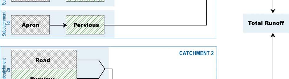
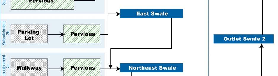
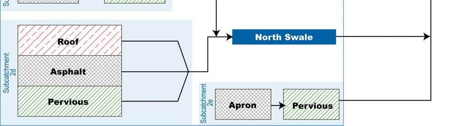
4 FIGURE 2 Drainage Flow Diagram of the Eurocopter Site 4
5 Performance Indicators Changes in hydrology have been identified as the leading cause of channel instability and aquatic habitat degradation (Center for Watershed Protection, 2003). The ability of LID techniques to reduce runoff volume is a key indication of their effectiveness in protecting stream health. Hence, a primary measure of performance for the LID scenarios is the total volume of runoff over the 11-year modeled time period. These scenarios involve various configurations of LID controls. In addition, hydrographs for several individual storm events were modeled to evaluate the following performance criteria: Runoff Quality: A storm with 1.2 inches of rain. Capture of this storm is presumed to meet a water quality criterion to remove 80% of total suspended solids (TSS). An actual storm with these characteristics occurred on May 3, Stream Channel Protection: A 1-year, 24-hour storm (3.3 inches) that roughly matches a storm that occurred on March 7, Extended detention for a storm of this magnitude is presumed to provide channel protection. Overbank Flood Protection: A 25-year, 24-hour storm (6.1 inches) that approximates a storm that occurred on May 2, Matching pre- and post-development peaks for this storm event in assumed to provide overbank flood protection. Flow duration curves for the period between 1992 and 2002 were derived for each LID scenario, alongside similar curves for as-built and pre-development conditions. The duration and magnitude of flows that exceed natural forested conditions is directly related to the level of stormwater related impacts on stream stability and aquatic habitat. Model Application and Results LID uses a variety of site planning and engineering techniques to control runoff. Under redevelopement, the applicability of these techniques depends on soil conditions, site usage and space constraints. Under new development conditions there is more flexibility as the hydrologic behavior can be included in planning the site and site features can be designed to be hydrologically functional. For the American Eurocopter site, bioretention swales were examined as LID controls. This type of control was deemed to be appropriate based on available as-built drawings for existing swales and ongoing site construction. Results of Modeled LID Scenarios A series of scenarios were modeled to demonstrate the potential hydrologic effectiveness of a range of LID techniques for the Eurocopter site. These scenarios included: Bioretention Swale Retrofits Retrofit Option 1: Soil Amendments A portion of the existing swales are excavated and backfilled with amended soils to provide additional opportunities for infiltration. 5
6 The absorbent soil layer was about 15 feet wide and extends to a depth of 36 inches below the swale bottom. The modeling results indicate that this retrofit could reduce total runoff volume by about 29 percent from as-built conditions, as shown in Figure 3. Retrofit Option 2: Bioretention Swales with Check Dams In addition to the amended soil placement described above, a series of check dams are placed every 100 feet, thus creating a series of bioretention cells where surface ponding can occur. The ponding depth would be a maximum of 18 inches at the downstream end of each cell, with an average ponding depth of 8 inches over the entire bioretention area. The modeling results indicate that this retrofit could reduce total runoff volume by about 43 percent (see Figure 3). Retrofit Option 3: Two-Layer Bioretention Swales with Check Dams The bioretention swales (same as Retrofit Option 2) are underlain by a 28-inch thick gravel layer with a 6 inch perforated underdrain. Total flow out of these two-layer swales consists of surface runoff plus underdrain flow. The underdrain flow can be considered clean runoff since it has treated by the amended soil layer. In addition, the infiltration process attenuates peak flows. The modeling results indicate that this retrofit reduced total surface runoff volume by about 79 percent (see Figure 3), which is actually below pre-development runoff volumes. However, the total runoff volume, including underdrain flow, is actually slightly higher than the single layer bioretention swale option (Retrofit Option 2). Two-layer bioretention swales tend to have significantly lower durations of surface ponding, and to be an effective design option for sites where soils have relatively poor infiltration capacity, such as the Eurocopter site. Retrofit Option 2 with Various LID BMPs In addition to Retrofit Option 2, all of the rooftop runoff was dispersed over the pervious area in the northeast corner of the lot, which was covered with 12 inches of landscaped amended soil. Similarly, amended soil layers were placed on pervious areas that drained paved surfaces. The east half of the parking area was covered by pervious paving, underlain by an 18-inch drain gravel layer. Similarly, the north half of the paved area on the north side of building was covered by pervious paving with a reservoir base course, which captures rainfall and runoff from the south half of this paved area. A lightweight extensive green roof with 4 inches of vegetated growing media covers the entire building rooftop, with a drainage layer underlying the growth media. Application of the LID measures described above dramatically reduced the level of surface runoff from the site. Total runoff volume was reduced by about 90 percent compared with as-built conditions, and well below pre-development runoff volumes, as shown in Figure 3. Runoff from small frequent storms, such as the water quality storm, was eliminated (see Figure 4a), and peak runoff rates were significantly reduced during larger storms, such the 1-yr channel protection storm (see Figure 4b). The flow duration curve could be reduced below the curve for pre-development conditions for the complete spectrum of rainfall conditions, as shown in Figure 5. These findings indicate 6
 FIGURE 4A Hydrographs for Various LID Retrofit Scenarios for 1.")
7 that the LID measures described above would achieve the specified performance standards. FIGURE 3 Runoff Volumes by Various LID Retrofit Scenarios for 1.2 inches of Storm (Water Quality Protection) FIGURE 4A Hydrographs for Various LID Retrofit Scenarios for 1.2 inches of Storm (Water Quality Protection) 7
8 FIGURE 4B Hydrographs for Various LID Retrofit Scenarios for 3.3 inches of Storm (Channel Protection) FIGURE 5 Flow Duration Curves for Various LID Retrofit Scenarios for 6.1 inches of Storm (Bank Protection) 8
9 Conclusions The LIFE model has proven to be an effective tool to simulate LID hydrology. The model was built on basic hydrologic principles and its main advantage is the ability to simulate a wide array of site-planning measures as well as engineered BMPs. References Center for Watershed Protection, Impacts of Impervious Cover on Aquatic Systems. Watershed Protection Research Monograph No. 1, Center for Watershed Protection, Elliott City, MD.142 pp. CH2M HILL, Atlanta Regional Commission. Metro North Georgia Water Planning District Watershed Management Plan. USDA Soil Conservation Service, National Soil Survey Center, Miscellaneous Publication State Soil Geographic (STATSGO): Data Use Information. 9
Green Infrastructure & Low Impact Development
 Green Infrastructure & Low Impact Development CITY OF COVINGTON STORMWATER MANAGEMENT WHAT IS GREEN INFRASTRUCTURE? Green infrastructure uses vegetation, soils and natural processes to manage water and
New Development Stormwater Guidelines
 New Development Stormwater Guidelines CITY OF MOUNTLAKE TERRACE Table of Contents Introduction... 2 Ecology s Minimum Requirements for stormwater management... 2 Description of the 9 Minimum Requirements...
Draft Impervious Cover Reduction Action Plan for West Long Branch Borough, Monmouth County, New Jersey
 Draft Impervious Cover Reduction Action Plan for West Long Branch Borough, Monmouth County, New Jersey Prepared for West Long Branch Borough by the Rutgers Cooperative Extension Water Resources Program
Draft Impervious Cover Reduction Action Plan for West New York, Hudson County, New Jersey
 Draft Impervious Cover Reduction Action Plan for West New York, Hudson County, New Jersey Prepared for the Town of West New York by the Rutgers Cooperative Extension Water Resources Program March 29, 2017
Appendices: Glossary. General Terms. Specific Terms. Low Impact Development Approaches Handbook
 67 67 General Terms Specific Terms 66 Low Impact Development Approaches Handbook The vocabulary of low impact development is evolving, and many terms are used interchangeably and to describe the same or
Impervious Cover Reduction Action Plan for Hampton Township, Sussex County, New Jersey
 Impervious Cover Reduction Action Plan for Hampton Township, Sussex County, New Jersey Prepared for Hampton Township by the Rutgers Cooperative Extension Water Resources Program November 8, 2016 Table
Old Mill Community Association Bioretention Facility
 Project Overview This project will install a bioretention facility in a community recreation area owned by the Old Mill Community Association, Inc. Drainage from the area is currently unmanaged and has
Impervious Cover Reduction Action Plan for City of Vineland, Cumberland County, New Jersey
 Impervious Cover Reduction Action Plan for City of Vineland, Cumberland County, New Jersey Prepared for the City of Vineland by the Rutgers Cooperative Extension Water Resources Program May 23, 2016 Table
4.5 City of Indianapolis Stormwater Green Infrastructure Guidance: Bioretention (rain gardens) Bioretention Fact Sheet Bioretention Technical Design
 Bioretention Fact Sheet Bioretention Technical Design") 4.5 City of Indianapolis Stormwater Green Infrastructure Guidance: Bioretention (rain gardens) Bioretention Fact Sheet Bioretention Technical Design Specification Bioretention O & M Manual Draft Green
4.5 City of Indianapolis Stormwater Green Infrastructure Guidance: Bioretention (rain gardens) Bioretention Fact Sheet Bioretention Technical Design Specification Bioretention O & M Manual Draft Green
Draft. Impervious Cover Reduction Action Plan for Dunellen Borough, Middlesex County, New Jersey
 Draft Impervious Cover Reduction Action Plan for Dunellen Borough, Middlesex County, New Jersey Prepared for Dunellen Borough by the Rutgers Cooperative Extension Water Resources Program September 22,
4. CONCEPT PLAN DEVELOPMENT
 4. CONCEPT PLAN DEVELOPMENT Concept Plan Step 1: Identify Site Constraints and Opportunities Review the existing site to identify constraints and opportunities for GI Practices to meet the RRv. Constraints
Modeling Cumulative LID Features for Floodplain Impacts in an Urban Watershed in Houston, TX
 Modeling Cumulative LID Features for Floodplain Impacts in an Urban Watershed in Houston, TX Christina Hughes, Phil Bedient cmhughes@rice.edu May 2, 2014 1 Modeling Cumulative LID Features for Floodplain
Bioretention cell schematic key
 Bioretention Cells Bioretention cell schematic key 1 3 Hardwood mulch 2 Curb cut 3 18-30 Modified soil 4 Stone aggregate choker layer 5 Stone aggregate base layer 6 Subdrain 7 Undisturbed soil 8 Overflow/Cleanout
Draft Rhode Island Stormwater Design and Installation Standards Manual
 Draft Rhode Island Stormwater Design and Installation Standards Manual Summary The May 2009 Public Review Draft version of the RI Stormwater Design and Installation Standards Manual consists of approximately
Urban Stormwater Management. Rebecca Leonardson Rui Teles Brooke Ray Smith
 Urban Stormwater Management Rebecca Leonardson Rui Teles Brooke Ray Smith Introduction Stormwater in Portugal Why urban stormwater is currently a problem What is green stormwater management? Why it is
HEALTH SCIENCES BUILDING REDEVELOPMENT PROJECT
 INTRODUCTION In recent years, the University of Cincinnati (University) has demonstrated a commitment to identifying and implementing sustainable goals and objectives throughout University s Uptown Campuses.
Pollutant Removal Benefits
 Bioswales Bioswales Similar to biocells, but have a slight, but positive grade toward an outlet Designed to convey the WQv event at very low velocities Promote filtration through native vegetation, infiltration
Selecting Appropriate Stormwater Control Measures for Your Development Project
 Phase II Post-Construction Stormwater Requirements Workshop - February 10, 2014 Selecting Appropriate Stormwater Control Measures for Your Development Project Jill Bicknell, P.E., EOA, Inc. Outline of
Draft. Impervious Cover Reduction Action Plan for Fair Haven, Monmouth County, New Jersey
 Draft Impervious Cover Reduction Action Plan for Fair Haven, Monmouth County, New Jersey Prepared for Fair Haven by the Rutgers Cooperative Extension Water Resources Program June 10, 2016 Table of Contents
Rebecca Dohn October 13, 2017
 Rebecca Dohn October 13, 2017 Why Green Infrastructure? Population Growth 46,000 45,000 44,000 43,000 42,000 41,000 40,000 39,000 38,000 37,000 36,000 Impervious Acres 2 Why Green Infrastructure? 3 Why
Draft Impervious Cover Reduction Action Plan for Newark, Essex County, New Jersey Volume 2
 Draft Impervious Cover Reduction Action Plan for Newark, Essex County, New Jersey Volume 2 Prepared for the City of Newark by the Rutgers Cooperative Extension Water Resources Program April 16, 2018 Table
Green Infrastructure and Low-Impact Development Technologies
 Green Infrastructure and Low-Impact Development Technologies The guiding principles of these technologies is to manage stormwater at their sources using natural means, and establish conditions so that
West Virginia Stormwater Management Manual: Methods.
 West Virginia Stormwater Management Manual: Methods Created to deliver targeted training on new tools and practices to improve the quality of stormwater runoff. www.cbstp.org www.chesapeakestormwater.net
Going Green with the NYS Stormwater Design Standards
 Going Green with the NYS Stormwater Design Standards Shohreh Karimipour, P.E. NYSDEC History of Stormwater Management Ancient Greek Cisterns Water Cistern Systems in Greece from Minoan to Hellenistic Period,
3. Are there any projects exempt from the definition of Regulated Projects?
 STORMWATER REQUIREMENTS: OVERVIEW OF PROVISION C.3 Background: On October 14, 2009, the Regional Water Quality Control Board, San Francisco Bay Region, issued a municipal regional stormwater permit (MRP)
Key elements : Filter Strips must be designed within parameters required by the Fort Wayne s Development Standards/Criteria Manual.
 4.4. Filter Strips Filter Strips are densely vegetated lands that treat sheet flow storm water from adjacent pervious and impervious areas. They function by slowing runoff, trapping sediment and pollutants,
C.3 STORMWATER TECHNICAL GUIDANCE. Table of Contents. Glossary... viii. Chapter 1 Introduction/How to Use this Handbook
 C.3 STORMWATER TECHNICAL GUIDANCE Table of Contents Glossary... viii Chapter 1 Introduction/How to Use this Handbook... 1-1 1.1 Purpose of this Handbook... 1-1 1.2 What is the Countywide Program?... 1-2
Can Urban Redevelopment Restore Aquatic Resources
 Can Urban Redevelopment Restore Aquatic Resources with Standards for Stormwater Retention and Landscape Performance? Rebecca C. Stack District of Columbia Department of the Environment Industry, Agriculture,
5. LOW IMPACT DEVELOPMENT DESIGN STANDARDS
 5. LOW IMPACT DEVELOPMENT DESIGN STANDARDS Low Impact Development (LID) requires a shift in stormwater management away from conveying runoff to a small number of downstream points through hydraulically
Planning, Design, and Construction of Green Infrastructure.
 Planning, Design, and Construction of Green Infrastructure www.water.rutgers.edu What is Green Infrastructure? an approach to stormwater management that is costeffective, sustainable, and environmentally
Slow it, Spread it, Sink it using Green Stormwater Infrastructure
 Milly Archer Water Resources Coordinator Becky Tharp Green Infrastructure Collaborative Slow it, Spread it, Sink it using Green Stormwater Infrastructure Overview Defining LID and GSI Hydrology and impacts
STORMWATER REPORT FOR WALMART SUPERCENTER STORE # SIOUX FALLS, LINCOLN COUNTY, SOUTH DAKOTA BFA PROJECT NO
 STORMWATER REPORT FOR WALMART SUPERCENTER STORE # 2443-00 SIOUX FALLS, LINCOLN COUNTY, SOUTH DAKOTA BFA PROJECT NO. 3286 March 1, 2012 I hereby certify that this engineering document was prepared by me
Keele Campus Storm Drainage. Presented by Mark Hagesteijn September 24, 2013
 Keele Campus Storm Drainage Presented by Mark Hagesteijn September 24, 2013 1 Presentation Overview Urbanization Impact on the Hydrologic Cycle Why Do We Manage Stormwater? Typical Stormwater Management
INTRODUCTION TO GREEN INFRASTRUCTURE HOW WE CAN PROTECT OUR COMMUNITIES AND OUR WATERS Maywood Public Library Bergen County, New Jersey
 INTRODUCTION TO GREEN INFRASTRUCTURE HOW WE CAN PROTECT OUR COMMUNITIES AND OUR WATERS Maywood Public Library Bergen County, New Jersey Jeremiah D. Bergstrom, LLA, ASLA Rutgers Cooperative Extension Water
Contents. Adapted/abbreviated from GSWMM Coastal Stormwater Supplement, August
 CH. 3 STORMWATER MANAGEMENT PRACTICES Contents Soil Restoration... 30 Site Reforestation/Revegetation... 32 Green Roofs... 35 Permeable Pavements... 37 Undisturbed Pervious Areas... 44 Vegetated Filter
CHAPTER 11 SITE DESIGN AND LOW IMPACT DEVELOPMENT
 CHAPTER 11 SITE DESIGN AND LOW IMPACT DEVELOPMENT Source: City of Bend Chapter Organization 11.1 Purpose... 11-1 11.2 Applicability... 11-1 11.3 Low Impact Development Overview... 11-2 11.3.1 Key Strategies...
Attachment 2: Permeable Pavement Design Guidelines
 Attachment 2: Permeable Pavement Design Guidelines Design of permeable pavement systems is critical if they are to function properly and efficiently. The area and shape are dependent on the site design,
WEFTEC.06. ** City of Caldwell, Idaho
 COST-BENEFIT ANALYSIS OF URBAN STORMWATER RETROFITS AND STREAM DAYLIGHTING USING LOW IMPACT DEVELOPMENT TECHNOLOGIES Sherrill Doran*, Dennis Cannon** * CH2M HILL, 322 East Front Street, Suite 200 Boise,
Appendix D - Technical Design Criteria for BMPs
 Appendix D - Technical Design Criteria for BMPs City of Wayzata Page 3 On-site infiltration features Definitions and Scope: Infiltration facilities are constructed basins or depressions located in permeable
Post-Construction Stormwater Management Checklist* (5,000 SF or Greater)
") Applicability: Required for projects that create and/or replace 5,000 square feet or greater of impervious surface (i.e. asphalt roads, concrete structures, building area, sidewalks, etc.). Impervious
Applicability: Required for projects that create and/or replace 5,000 square feet or greater of impervious surface (i.e. asphalt roads, concrete structures, building area, sidewalks, etc.). Impervious
Draft Impervious Cover Reduction Action Plan for Newark, Essex County, New Jersey Volume 3
 Draft Impervious Cover Reduction Action Plan for Newark, Essex County, New Jersey Volume 3 Prepared for the City of Newark by the Rutgers Cooperative Extension Water Resources Program April 16, 2018 Table
Managing Stormwater within the Road Right-of-Way: An Urban NAI Approach
 Turgay Dabak, Joni Calmbacher, Sara DeGroot, Andrea Ryon Managing Stormwater within the Road Right-of-Way: An Urban NAI Approach Presentation Outline Project Background Project Overview BMPs Evaluated
Zoning Regulation Amendments Adopted December 19, 2018 effective date January 7, 2019
 Zoning Regulation Amendments Adopted December 19, 2018 effective date January 7, 2019 Article 2 General Provisions Section 2.2 Definitions Definitions- FIRE LANE The aisle immediately adjacent to a building
Beyond Rain Gardens Advancing the Use of Compost for Green Infrastructure, Low Impact Development, & Stormwater Management
 Beyond Rain Gardens Advancing the Use of Compost for Green Infrastructure, Low Impact Development, & Stormwater Management VORS 2018 Stormwater Management Session 2 Stormwater Management, Green Infrastructure,
Rainwater Management an issue for the 21 st Century. Hydrological Cycle
 Canadian Society of Landscape Architects CONGRESS 2014 Rainwater Management an issue for the 21 st Century Don Crockett, BCSLA, CSLA Principal, Golder Associates Ltd. May 2014 Hydrological Cycle PRE- URBAN
Case Study: Dallas Green Infrastructure for Stormwater
 Case Study: Dallas Green Infrastructure for Stormwater Extension and Research Sandhya Mohan Fouad H. Jaber, PhD Biological and Agricultural Engineering Texas Agrilife, Texas A&M University System Urban
4.6. Low Impact and Retentive Grading
 4.6. Low Impact and Retentive Grading Low Impact Grading techniques focus on utilizing existing topography during Site layout to minimize cost. Proposing structures, roads, and other impervious surfaces
IMPLEMENTING STORMWATER MANAGEMENT REQUIREMENTS FOR DEVELOPMENT
 IMPLEMENTING STORMWATER MANAGEMENT REQUIREMENTS FOR DEVELOPMENT 4.1 Overview Description: Requirements and standards for controlling runoff from development are critical to addressing water quantity and
Sustainable Stormwater Management with Low Impact Development (LID)
") Sustainable Stormwater Management with Low Impact Development (LID) Chui Ting Fong, May Department of Civil Engineering The University of Hong Kong HKIE Seminar Nov 27, 2014 1 Hydrologic Impact of Urbanization
Sustainable Stormwater Management with Low Impact Development (LID) Chui Ting Fong, May Department of Civil Engineering The University of Hong Kong HKIE Seminar Nov 27, 2014 1 Hydrologic Impact of Urbanization
Low Impact Development and Green Infrastructure 101. The new paradigm for stormwater management
 Low Impact Development and Green Infrastructure 101 The new paradigm for stormwater management Wayne Petersen Urban Conservationist 515-281-5833 Wayne.Petersen@iowaagriculture.gov IDALS s Urban Conservation
Post Construction BMPs
 Post Construction BMPs Why are Post Construction BMPs important? With increased development brings the increase of impervious cover Parking lots, rooftops, driveways Storm water runoff volume increases
Structural Stormwater Best Management Practices
 Structural Stormwater Best Management Practices for Small Commercial and Residential Applications Timothy Bruno Watershed Manager PA Department of Environmental Protection What are STRUCTURAL BMPs? Physical
2008 SWMM, 2010 Revision City of Tacoma
 2008 SWMM, 2010 Revision City of Tacoma 2.2.3.1 BMP L630 Rain Gardens Purpose and Definition Bioretention areas are shallow stormwater retention facilities designed to mimic forested systems by controlling
Green Infrastructure Stormwater Management Applications in the Pines Frequently Asked Questions and Example Projects
 Green Infrastructure Stormwater Management Applications in the Pines Frequently Asked Questions and Example Projects Stephen J. Souza, Ph.D Princeton Hydro, LLC 1108 Old York Road Suite 1, P.O. Box 720
WQ-23 MOUNTAINOUS AND STEEP SLOPE SITES
 Greenville County Technical Specification for: WQ-23 MOUNTAINOUS AND STEEP SLOPE SITES 1.0 Mountainous and Steep Slope Sites 1.1 Description The geographic locations of portions of Greenville County are
J. Paul Guyer, P.E., R.A.
 J. Paul Guyer, P.E., R.A. Paul Guyer is a registered civil engineer, mechanical engineer, fire protection engineer, and architect with over 35 years experience in the design of buildings and related infrastructure.
Rain Gardens Water Quality the Way Mother Nature Intended
 Rain Gardens Water Quality the Way Mother Nature Intended Maintenance Discussion Design Discussion Susan Morgan, Ph.D, PE Southern Illinois University Edwardsville smorgan@siue.edu (618) 650 5014 Michael
County of Prince Edward. Stormwater Management Plan. Agreement in lieu of a Stormwater Management Plan
 County of Prince Edward Stormwater Management Program Date: E-Permitting Number: This stormwater management plan (Agreement) is hereby submitted by the Owner to specify the methods that will be implemented
Hydrologic Assessment of using Low Impact Development to Mitigate the Impacts of Climate Change. Chris Jensen, AScT Master of Science Thesis
 Hydrologic Assessment of using Low Impact Development to Mitigate the Impacts of Climate Change Chris Jensen, AScT Master of Science Thesis Bowker Creek Initiative April 12, 2012 Outline 1. Future Impacts
Placement of the soil should be in lifts of mm and loosely compacted (tamped lightly with a backhoe bucket).
.") 6 Rain Gardens Rain Gardens 6.1 Introduction A rain garden is used to attenuate peak flows and to provide stormwater treatment. Rain gardens use the concept of bioretention, a water quality practice in
6 Rain Gardens Rain Gardens 6.1 Introduction A rain garden is used to attenuate peak flows and to provide stormwater treatment. Rain gardens use the concept of bioretention, a water quality practice in
Introduction to Low Impact Development. Fred Milch. East Central Florida Regional Planning Council
 Introduction to Low Impact Development Fred Milch East Central Florida Regional Planning Council Low Impact Development (LID) Low impact development (LID) is a term used to describe a land planning and
PAVING PARKING AREAS AND ROADS DESCRIPTION. Alternate Names: Pavement Practices, Impervious Paving
 4.2-i PAVING PARKING AREAS AND ROADS Alternate Names: Pavement Practices, Impervious Paving DESCRIPTION All roads, driveways, and parking lots proposed for year-round use shall be paved with a hard plowable
Article 20 Stormwater Management
 Article 20 Section 20.01 Intent Article 20 The purpose of this Article is to protect the health, safety, and general welfare of the citizens by requiring compliance with accepted standards and practices
NEORSD Green Infrastructure Grant (GIG) Program Opening Remarks
 Program Opening Remarks") NEORSD Green Infrastructure Grant (GIG) Program Opening Remarks 2019 NEORSD GIG Eligibility and Technical Requirements Project must be located in the Sewer District s combined sewer area Location Applicant
NEORSD Green Infrastructure Grant (GIG) Program Opening Remarks 2019 NEORSD GIG Eligibility and Technical Requirements Project must be located in the Sewer District s combined sewer area Location Applicant
TENNESSEE GAS PIPELINE COMPANY, L.L.C.
 TENNESSEE GAS PIPELINE COMPANY, L.L.C. HYDROLOGIC AND HYDRAULIC CALCULATIONS FOR ACCESS ROADS ALONG THE CONNECTICUT PIPELINE EXPANSION PROJECT CONNECTICUT LOOP Submitted by: Tennessee Gas Pipeline Company,
Charles County, MD Low Impact Development (LID)/ Environmental Site Design (ESD) Ordinance & Design Manual
/ Environmental Site Design (ESD) Ordinance & Design Manual") Charles County, MD Low Impact Development (LID)/ Environmental Site Design (ESD) Ordinance & Design Manual Presentation Highlights Background What is LID / ESD? Why adopt LID/ESD MD SWM Act 2007 Planning
Charles County, MD Low Impact Development (LID)/ Environmental Site Design (ESD) Ordinance & Design Manual Presentation Highlights Background What is LID / ESD? Why adopt LID/ESD MD SWM Act 2007 Planning
6.1 Bioretention Areas
 SAN MATEO COUNTYWIDE WATER POLLUTION PREVENTION PROGRAM 6.1 Bioretention Areas Figure 6-1. Bioretention Area. Source: City of Brisbane Bioretention areas 1, or rain gardens, are concave landscaped areas
GREEN ON THE HORIZON. Challenges of Integrating LID into New Development. Southeast Stormwater Association
 GREEN ON THE HORIZON Challenges of Integrating LID into New Development Southeast Stormwater Association Annual Seminar, Charleston SC October 9, 2014 JENNIFER A. NUNN, PE THE BALMORAL GROUP Acknowledgments
Urban Water Management and Soils (ESRM 311 & SEFS 507)
") Urban Water Management and Soils (ESRM 311 & SEFS 507) Cougar Mtn Regional Wildland Park & Lakemont Blvd, Bellevue WA Lecture Today Some Urban Water management terms Examples of water management in urban
Urban Water Management and Soils (ESRM 311 & SEFS 507) Cougar Mtn Regional Wildland Park & Lakemont Blvd, Bellevue WA Lecture Today Some Urban Water management terms Examples of water management in urban
Three Rivers Park District Administration Center Rain Garden
 Three Rivers Park District Administration Center Rain Garden Introduction There are significant changes to the hydrologic regime and nutrient loading following urban and industrial development. The post-development
Modeling Rain Garden LID Impacts on Sewer Overflows
 7 Modeling Rain Garden LID Impacts on Sewer Overflows Uzair (Sam) M. Shamsi In September 2010, the U.S. Environmental Protection Agency (USEPA) released a new version (5.0.021) of Storm Water Management
Status Update of Turf Work Order. January 18, 2013 MIDS Workgroup Meeting
 Photo: http://en.wikipedia.org/wiki/file:seededfertilizedlawn.jpg Status Update of Turf Work Order January 18, 2013 MIDS Workgroup Meeting Categories of Turf Credits 1. Impervious Surface Disconnection-turf
WQ-07 INFILTRATION TRENCH
 Greenville County Technical Specification for: WQ-07 INFILTRATION TRENCH 1.0 Infiltration Trench 1.1 Description Infiltration Trenches are excavations filled with stone to create an underground reservoir
Tale of Two Cities: Exploring How Two Communities are Using Green Infrastructure to Reduce Flood Risk
 Tale of Two Cities: Exploring How Two Communities are Using Green Infrastructure to Reduce Flood Risk NACo Steering Subcommittees Education Session Lori Cary-Kothera NOAA Coastal Services Center Issue
Green Infrastructure Overview
 Green Infrastructure Overview Christopher C. Obropta, Ph.D., P.E. obropta@envsci.rutgers.edu Jeremiah Bergstrom, LLA, ASLA jbergstrom@envsci.rutgers.edu February 26, 2016 Water Resources Program NJDEP
Citywide Integrated Stormwater Management Plan (ISMP) DRAFT ACTION PLAN REVIEW Public Consultation November 16 th, 2016
 DRAFT ACTION PLAN REVIEW Public Consultation November 16 th, 2016") Citywide Integrated Stormwater Management Plan (ISMP) DRAFT ACTION PLAN REVIEW Public Consultation November 16 th, 2016 1 Agenda DRAFT ACTION PLAN REVIEW Public Consultation Time 6:00 6:05 6:05 6:20 6:20
Citywide Integrated Stormwater Management Plan (ISMP) DRAFT ACTION PLAN REVIEW Public Consultation November 16 th, 2016 1 Agenda DRAFT ACTION PLAN REVIEW Public Consultation Time 6:00 6:05 6:05 6:20 6:20
Rainfall Capture and Green Subdivision Design:
 Rainfall Capture and Green Subdivision Design: Applying the Water Balance Model Kim Stephens, MEng, PEng, Project Coordinator Inter-Governmental Partnership from Stormwater Management to Rainwater Management
Evaluating Urban Stormwater Retrofits in the SE US Coastal Plain
 Evaluating Urban Stormwater Retrofits in the SE US Coastal Plain 2017 Florida Stormwater Association June 14-17, 2017 Eban Z. Bean, PhD, PE Assistant Professor & Extension Specialist Agricultural and Biological
Stormwater & South Carolina. A Case for Low Impact Development
 Stormwater & South Carolina A Case for Low Impact Development what is stormwater? stormwater & development Volume of Water stormwater & development Peak Flow Urban Natural Peak Flow Rain Event Time Components
Stormwater Management Techniques WMPF LAND USE TRAINING INSTITUTE MARCH 14, 2018
 Stormwater Management Techniques WMPF LAND USE TRAINING INSTITUTE MARCH 14, 2018 Potential Impacts of New Development Urban development can significantly increase stormwater runoff Water quality considerations
DEALING WITH STORM WATER MANAGEMENT
 December 2012 DEALING WITH STORM WATER MANAGEMENT This fact sheet provides information on the guiding principles of storm water management practices, explains the difference between structural and non-structural
Monitoring Flow and Quality for Stormwater Control Measures
 Monitoring Flow and Quality for Stormwater Control Measures Robert Traver, Ph.D., PE, D.WRE. Andrea L. Welker, PhD, PE Bridget Wadzuk, PhD, John Komlos, PhD The mission of the Villanova Urban Stormwater
Draft Impervious Cover Reduction Action Plan for Newark, Essex County, New Jersey Volume 1
 Draft Impervious Cover Reduction Action Plan for Newark, Essex County, New Jersey Volume 1 Prepared for the City of Newark by the Rutgers Cooperative Extension Water Resources Program April 16, 2018 Table
Post-Construction BMPs
 Overview of Post-Construction BMPs FOR COMMERCIAL LANDSCAPERS DAN BOGOEVSKI OHIO EPA NORTHEAST DISTRICT OFFICE OCTOBER 1, 2013 What Are Post-Construction BMPs? Permanent practices that reduce storm water
Community LID Workgroup Issue Paper #6
 Community LID Workgroup Issue Paper #6 Topic: Hard and Impervious Surface Coverage Limits Objective: Minimize the amount of hard and impervious surfaces in developments to allow more stormwater to infiltrate
Introduction to Low Impact Development. Dr Kathy Chaston Coral & Coastal Management Specialist NOAA Office of Ocean & Coastal Resource Management
 Introduction to Low Impact Development Dr Kathy Chaston Coral & Coastal Management Specialist NOAA Office of Ocean & Coastal Resource Management http://hawaii.gov/dbedt/czm/resource/publication.php A Comprehensive
Urban Water Management (ESRM 311 & SEFS 507) Cougar Mtn Regional Wildland Park & Lakemont Blvd, Bellevue WA
 Cougar Mtn Regional Wildland Park & Lakemont Blvd, Bellevue WA") Urban Water Management (ESRM 311 & SEFS 507) Cougar Mtn Regional Wildland Park & Lakemont Blvd, Bellevue WA Lecture Today Urban Water management terms Examples of water management in urban areas Field
Urban Water Management (ESRM 311 & SEFS 507) Cougar Mtn Regional Wildland Park & Lakemont Blvd, Bellevue WA Lecture Today Urban Water management terms Examples of water management in urban areas Field
Example Stormwater Control Plan For a Residential Subdivision Project. Whispering Pines Lane Anytown, USA. February 21, 2018
 Example Stormwater Control Plan For a Residential Subdivision Project Whispering Pines Lane Anytown, USA February 21, 2018 XYZ Corporation Jane Jones, 925-555-1212 This example prepared by Dan Cloak Environmental
26 Attachment 2. Township of New Britain APPENDIX B STORMWATER MANAGEMENT DESIGN CRITERIA
 (26, APPENDIX B) 26 Attachment 2 Township of New Britain APPENDIX B STORMWATER MANAGEMENT DESIGN CRITERIA TABLE B-1 DESIGN STORM RAINFALL AMOUNT Source: Field Manual of Pennsylvania Department of Transportation
Sustainable Stormwater Retrofit Best Practices
 Sustainable Stormwater Retrofit Best Practices Presenter Zach Sample, PE Stormwater Products Manager XP Solutions XP Solutions has a long history of Providing original, high-performing software solutions
Stormwater Control Plan: Small (Tier 1) Land Development Project
 Land Development Project") Stormwater Control Plan: Small (Tier 1) Land Development Project Project ID for Tracking (for City Staff only): The California Regional Water Quality Control Board for the Central Coast Region (Water Board)
Stormwater Control Plan: Small (Tier 1) Land Development Project Project ID for Tracking (for City Staff only): The California Regional Water Quality Control Board for the Central Coast Region (Water Board)
Building Green: An Update on Atlanta's Green Infrastructure Approach
 City of Atlanta Mayor Kasim Reed Department of Watershed Management Building Green: An Update on Atlanta's Green Infrastructure Approach Todd Hill, PE, LEED AP, EnvSP Watershed Director 2016 Eastern Regional
Final Impervious Cover Assessment for Upper Deerfield Township, Cumberland County, New Jersey
 Final Impervious Cover Assessment for Upper Deerfield Township, Cumberland County, New Jersey Prepared for Upper Deerfield Township by the Rutgers Cooperative Extension Water Resources Program September
Use of Best Management Practices
 Use of Best Management Practices Presented at the ANJEC Flood Hazard Workshop Bordentown, NJ March 13, 2008 Stormwater BMPs "a technique, measure or structural control that is used for a given set of conditions
A P P E N D I X D. Project Stormwater Plan Worksheets
 A P P E N D I X D Worksheets for Section 1: Basic Project Information This worksheet must be filled out for all projects required to implement the 2015 Post- Construction Stormwater Standards Manual. A
Lincoln 270. City of Lincoln. Stormwater Management Plan. April 2, 2013
 Lincoln 270 City of Lincoln Stormwater Management Plan April 2, 2013 # 2005.48 Prepared By: Civil Engineering Solutions, Inc. 590 E Street Lincoln, Ca 95648 (916) 645 5700 1.0 Background: The project site
Local Stormwater Retrofit Case Studies. Westmoreland County Conservation District Updated 11/2011
 Local Stormwater Retrofit Case Studies Westmoreland County Conservation District Updated 11/2011 WCD 2010 Why we do Sustainable Stormwater Management Retrofits To reduce flooding events and combined sewer
Donald Carpenter, Ph.D. Laura Hallam Lawrence Technological University June 23, 2008 MWEA Annual Conference Watershed Session
 Investigation of Rain Garden Planting Mixtures Donald Carpenter, Ph.D. Laura Hallam Lawrence Technological University June 23, 2008 MWEA Annual Conference Watershed Session What is a Rain Garden? What
MDOT Stormwater BMPs: The Challenge of Design. Janeen McDermott, PE Dan DeVaun, PE
 MDOT Stormwater BMPs: The Challenge of Design Janeen McDermott, PE Dan DeVaun, PE June 25, 2018 Outline Water Quality Treatment Water Quality Treatment Volume Guidelines Example Project BMP Design Challenges
Chapter 3 Site Planning and Low Impact Development
 CHAPTER 3 Site Planning and Low Impact Development Chapter 3 Site Planning and Low Impact Development 3.0 Introduction The City of Charleston requires that major residential, large commercial (>1 acre),