Roanoke Rapids Streetscape Master Plan. City Council Presentation
|
|
|
- Valerie Patrick
- 5 years ago
- Views:
Transcription

1

2 SCHEDULE: Stakeholder Meeting/Kick off November,2016 Master Planning Phase (November March 2017) Public Meeting #1 December 13, 2016 Review Meeting with Key Stakeholders Refine Concepts Based on Input Public Meeting #2 February 20, 2017 Refine Concepts Based on Input Streetscape Master Plan Report Draft Submitted March, 2017 May 16, 2017


3 Public Meeting #1


4 What are the Goals and Objectives for the Roanoke Avenue Streetscape Project? Improved economic potential Improved Pedestrian Safety Improved access to parking Maintain small town character


5 What are the Goals and Objectives for the Roanoke Avenue Streetscape Project? Improved economic potential Increase public engagement and sense of ownership in proposed redevelopment Create an attractive and comfortable overall streetscape which encourages people to linger. - Business friendly incentives, etc.
6 What are the Goals and Objectives for the Roanoke Avenue Streetscape Project? Improved Pedestrian Safety Better visibility at pedestrian crossings Provide appropriate lighting in public areas Improve overall walkability on The Avenue
7 What are the Goals and Objectives for the Roanoke Avenue Streetscape Project? Improved access to parking Provide safe, easy connections to off street parking Implement policies which discourage employees from taking spaces in front of shops


8 What are the Goals and Objectives for the Roanoke Avenue Streetscape Project? Maintain small town character Strengthen linkages to adjacent residential communities Streetscape improvements reinforce a sense of place by clearly reflecting local vernacular


9 What are the Goals and Objectives for the Roanoke Avenue Streetscape Project? Maintain small town character Streetscape improvements reinforce a sense of place by clearly reflecting local vernacular


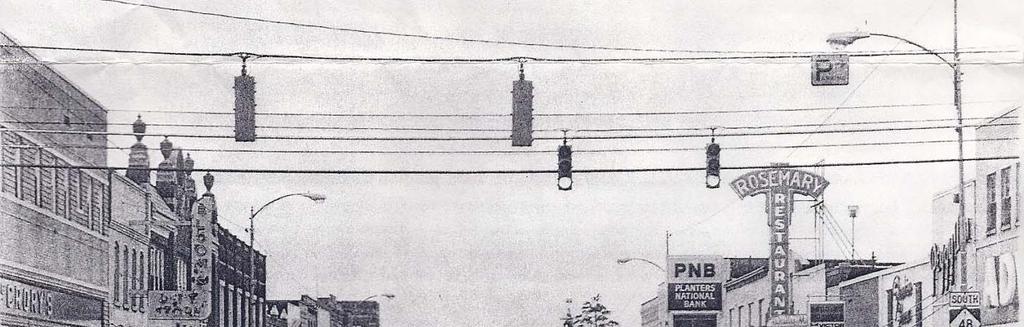
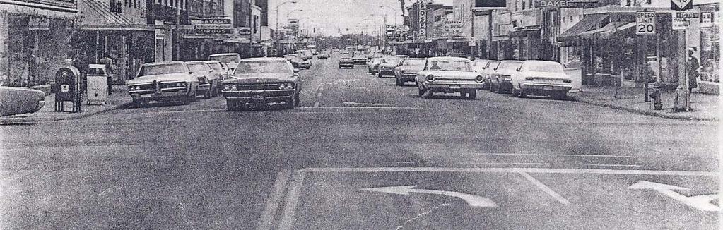
10 What are the Goals and Objectives for the Roanoke Avenue Streetscape Project? Maintain small town character Strengthen linkages to adjacent residential communities Streetscape improvements reinforce a sense of place by clearly reflecting local vernacular Provide places for community activities to occur Façade improvements to restore the beauty of historic buildings

11 Public Meeting #2

12 Preferred Concept

13 Preferred Concept


14 Comments: Natural stone and slab are very nice I like the cement benches, large pots as decoration. Recommendations: Stone seat walls. Boulder seating in special areas and clusters in landscape beds. Metal benches with backs near store fronts.. Seating Preferred Furnishings


15 Recommendations: Existing lamp posts with new banners. Sign posts to match lamp posts Neighborhood markers made from reclaimed brick salvaged from mills. Posts and Markers Preferred Furnishings


16 Comments: Decorative brick with alternating colors is really strong. I like the crosswalk design ideas. Crosswalks need to be made visible. Recommendations: Brick crosswalks to coordinate with sidewalk pavers. High visibility crosswalks where drivers need heightened awareness of pedestrian activity. I like the idea of the variety of red and white brick at intersections. Crosswalks Preferred Materials


17 Zelkova RECOMMENDED Princeton American Elm Trident Maple Comments: Please no trees in front of store fronts. Holly trees need to be replaced with more appropriate plantings. Make sure the trees don t damage the sidewalks or block businesses I think greenery should be kept low. Vegetation with various textures, heights and colors I like the grates around trees. Light posts would be a better option than trees. Street Trees
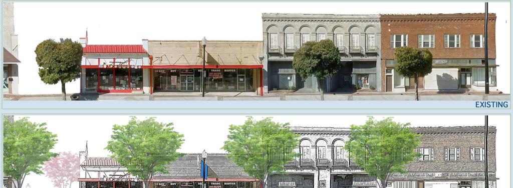

18 Typical Streetscape Elevation
19 What are the Goals and Objectives for the Roanoke Avenue Streetscape Project? Improved Pedestrian Safety (and experience) Improve overall walkability on The Avenue Better visibility at pedestrian crossings Provide appropriate lighting in public areas

20 What makes a place walkable?* Imageability The quality of a place that makes it distinct, recognizable and memorable * Dukes, Alexander, economy big boxes urban centers and placemaking
21 What makes a place walkable?* Imageability Enclosure The degree to which the landscape is defined by vertical elements impacts a persons level of comfort Source: * Dukes, Alexander, economy big boxes urban centers and placemaking

22 What makes a place walkable?* Imageability Enclosure Human Scaled Elements relate more to human comfort than to the vehicle Source: * Dukes, Alexander, economy big boxes urban centers and placemaking

23 What makes a place walkable?* Imageability Enclosure Human Scaled Transparency The degree to which people can perceive what lies beyond * Dukes, Alexander, economy big boxes urban centers and placemaking

24 What makes a place walkable?* Imageability Enclosure Human Scaled Transparency Complexity Visual richness * Dukes, Alexander, economy big boxes urban centers and placemaking
 Better visibility at pedestrian crossings Provide appropriate lighting in public areas Improve")
25 What are the Goals and Objectives for the Roanoke Avenue Streetscape Project? Improved Pedestrian Safety (and perception of safety) Better visibility at pedestrian crossings Provide appropriate lighting in public areas Improve overall walkability on The Avenue Source: Institute of Transportation Engineers (ITE)

26 Benefits of Curb Extensions - Increased pedestrian visibility at intersections through improved sight lines; - Decreased pedestrian exposure to vehicles by shortening the crossing distance; - Reduced vehicle turn speeds by physically and visually narrowing the roadway; - Increased pedestrian waiting space; - Additional space for street furnishings, plantings and other amenities; - Reduced illegal parking at corners, crosswalks and bus stops; - Facilitated ability to provide two curb ramps per corner.
27 AutoTURN Simulation Curb Extensions


28 Mid Block Crossing Recommended between 2 nd and 3 rd Streets and 9 th and 10 th Streets

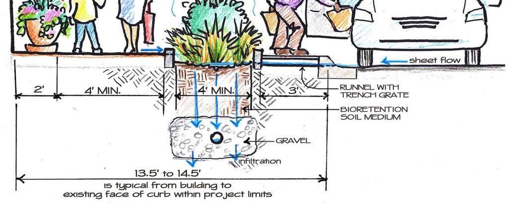
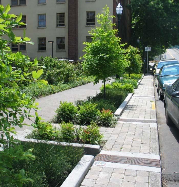
29 Infiltration Planters Recommended in curb extensions

30 Overall Streetscape Zones

31 Comments: Love making use of Depot. Trees in middle of street would be great if room allows. Love the idea of making use of the Depot, but moving out to the Allsbrook Hwy intersection may be difficult, and possibly unsafe. Like the fact that they could do something to make you feel more welcome. I like the greening around the train depot. I like the greenery idea #1 priority is gateways. Gateway Conceptual


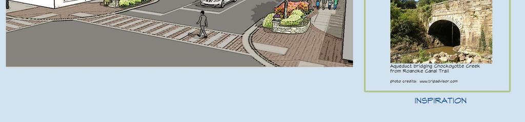
32 Recommendations: Add vegetation Make the Old Depot a focal point Consult with NCDOT and CSX pertaining ROW restrictions Gateway Precedent Mebane, NC
")
33 Comments: Median in center of road to link both ends of the Avenue together through the residential area. Sidewalk in center median down entire avenue. Love center islands and kick outs [curb extensions] Recommendations: Add low maintenance vegetation in center islands Use vegetation for selective screening Gateway (South) 14 th t0 12 th Street

![Love center islands and kick outs [curb extensions] Recommendations: Add low maintenance vegetation in](/docs-images/90/102633106/images/34-4.jpg "center islands Use vegetation for selective screening Find opportunities to incorporate public art to add")
34 Comments: Median in center of road to link both ends of the Avenue together through the residential area. Sidewalk in center median down entire avenue. Love center islands and kick outs [curb extensions] Recommendations: Add low maintenance vegetation in center islands Use vegetation for selective screening Find opportunities to incorporate public art to add interest in the landscape Gateway (South) 14 th t0 12 th Street

 1")
35 Recommendations: Add vegetation Add brick crosswalks Possibly curb extensions Gateway (North) 1 st Street to Canal Museum


36 Recommendations: Add low maintenance vegetation in center islands Gateway (North) 1st Street to Canal Museum
 Gateway (North) 1 st Street to Canal")
37 Recommendations: High visibility crossing at Canal Museum (possibly art) Gateway (North) 1 st Street to Canal Museum

 Safety (and perception of safety) /lighting.")
38 What are the Goals and Objectives for the 1026 Lot? The function of the space is intended as: Mid block access to parking lot Seasonal events Community functions Provide green space where little exists along the Avenue Convenient and comfortable space to have lunch/take a break from the office. (wifi availability) Safety (and perception of safety) /lighting. Provide an attractive space to serve as inspiration and a catalyst for future development

39 Comments: Great place for artists to play, draw, etc. Picnic tables, benches, greens, walkway, wireless internet, music nights, local artists. This is inviting, and shows artistic concept with different angles. This is strong. It is a good use of that space that can be converted for multiple uses. I like the fact that there will be better lighting and easy access to parking. Would like a downtown Farmers Market space at 1026 location. Concern about skaters Prefer this concept. Need good lighting for safety. Needs to have post lighting. Some type of separation from the next building I like the idea of using plants to keep the area from being just a straight walk through. I would like to see art displayed on the walls. Offset pattern nice and prefer it over straight in to parking. Love uplights in trees and would also like rope lights added. Love the historical lighting on façade. The fountain is good The overhead lighting is a good look. Diagonal seating gives the area diversity plus seating. The designs in paving are awesome looking. Possibly in the future. I like this. Great look! 1026 Roanoke Avenue Conceptual

40 1026 Roanoke Avenue Concept A


41 Recommendations: Diagonal raised planting beds; Pavement and site furnishings and elements coordinate with streetscape; Implement Crime Prevention Through Environmental Design (CPTED) strategies; Wi fi availability; Consult with an architect about safe removal of mastic or cover it up Roanoke Avenue Concept A
42 Improving Grant Funding Potential Show community support Demonstrate public sector commitment Reflect current trends Complete Streets (bicycles and pedestrians) Green infrastructure/energy efficient /stormwater management Include the Arts Provide accommodations for community events.
43 Thank you!
Fifth and Detroit Street Design May 2017 Capital Improvements Committee. DOWNTOWN Street Design
 1 Fifth and Detroit Street Design May 2017 Capital Improvements Committee Agenda 2 Review Street Configuration Prior Meeting Review Outreach Synopsis Functional Street Design Refinements Curb Edge, Turning
COMPLETE GREEN STREET CHECKLIST
 COMPLETE GREEN STREET CHECKLIST This document was developed to dissect the structure of an urban street and explore opportunities to make our streets more complete while also integrating green street strategies.
MISSION STREETSCAPE PLAN. Neighborhood Commercial Streets handle continuous activity. Neighborhood Commercial STREET ROW: Main Design Treatments
 Neighborhood Commercial STREET ROW: 64-80 Main Design Treatments CORNER reduce crossing distance for pedestrians, create entrances to a residential area and slow cars down. help widen sidewalk allocating
Maplewood Avenue Downtown Complete Street Project
 Maplewood Avenue Downtown Complete Street Project Second Public Meeting January 24, 2018 Welcome and Introduction of Project Team City Planning and Public Works Staff City of Portsmouth Juliet Walker Planning
Conceptual Design. Main Street Enhancement and Extension Project. Bothell, Washington. June 11, 2009
 Conceptual Design Main Street Enhancement and Extension Project Bothell, Washington June 11, 2009 Berger/ABAM Engineers and Cascade Design Collaborative, Inc For Main Street Bothell to succeed it must
Main Street Reconstruction From Ninth Line to Stouffer Street. Town of Whitchurch-Stouffville. Public Information Centre
 Main Street Reconstruction From Ninth Line to Stouffer Street Town of Whitchurch-Stouffville Public Information Centre November 23, 2016 4:30 to 6:00 pm & 7:00 to 8:00 pm 6240 Main Street, Stouffville
Project Consulting Team:
 THE DOWNTOWN CHERRYVILLE LAND USE + STREETSCAPE MASTER PLAN WAS FUNDED THROUGH THE GENEROUS DONATIONS OF THE FOLLOWING: The Community Foundation of Gaston County ElectriCities of North Carolina The Cherryville
To ensure human scale design, the towers step back from the facade of the building after four stories.
 41 40 SPRING GARDEN WEST A DESIGN BY PUBLIC ENGAGEMENT Chapter 3 Design SETBACK (SPRING GARDEN WEST LOOKING SOUTH) To ensure human scale design, the towers step back from the facade of the building after
ANCHOR TO ANCHOR. Rescale the street to create an iconic boulevard.
 ANCHOR TO ANCHOR Rescale the street to create an iconic boulevard. UR NE ER UV GO NE LA OBJECTIVES 1. Maintain appropriate traffic flow and prioritize commercial curb access 2. Mark gateways at the street
Town Center (part of the Comprehensive Plan)
") Town Center (part of the Comprehensive Plan) Mercer Island Town Center Looking North (2014) In 1994, a year-long process culminated in a set of design guidelines and code requirements for the Town Center
Town Center (part of the Comprehensive Plan) Mercer Island Town Center Looking North (2014) In 1994, a year-long process culminated in a set of design guidelines and code requirements for the Town Center
Mississippi Drive Corridor Revitalization. A DestinationTransportation Project...
 Mississippi Drive Corridor Revitalization A DestinationTransportation Project... Mississippi Drive Corridor Revitalization Welcome! Tonight s Agenda: Further define the Scope of the Project Discuss the
PUBLIC RIGHT-OF-WAY IN THIS CHAPTER PUBLIC REALM
 PUBLIC RIGHT-OF-WAY This section provides design guidelines for improvements in the public right-of-way. The public right-of-way refers to streets, sidewalks, non-vehicular thoroughfares, parks and greenways
GREENING THE BOULEVARD Master Plan Concepts for Venice Boulevard between Lincoln and Sawtelle
 GREENING THE BOULEVARD Katherine Spitz Associates Inc. 4212½ Glencoe Avenue Marina Del Rey, CA 90292 310 574 4460 Fax 574 4462 January 2008 Table of Contents Overview Proposed Design Improvements Illustration
VEHICULAR AND PEDESTRIAN CIRCULATION
 This perspective sketch communicates the intended character and quality of a proposed streetscape design. Locate benches near a major intersection where people tend to gather. Seating and lighting provide
BUSINESS DISTRICT DESIGN GUIDELINES
 Des Plaines, Illinois Prepared for the City of Des Plaines by: The Lakota Group Laurie Marston, AICP March 2005 Section 5: Streetscape Elements Business District Design Guidelines STREETSCAPE ELEMENTS
Table of Contents. Elm Avenue Improvement Plan City of Waco, Texas. Introduction 1. Existing Context 1 Figure 1 2.
 Table of Contents Introduction 1 Existing Context 1 Figure 1 2 Plan Guidelines 3 Future Urban Form 4 The West-End 4 Main Street 6 The East-End 7 Figure 2 9 Public Improvement Recommendations 7 General
Technical Advisory Committee
 CULVER DOWNTOWN STREETSCAPE PLAN STREETSCAPE IDEAS REPORT 01.08.2008 Project Team Matt Crall, Transportation and Growth Management Quick Response Program Donna McCormack, City of Culver Darrell Newton,
Building Great Neighbourhoods. Strathcona
 Building Great Neighbourhoods Strathcona March 21, 2018 Becky Redford Project Manager, Planning & Design Building Great Neighbourhoods Integrated Infrastructure Services Welcome and Purpose To provide
Commercial Node Plan Devine Street/Jackson Blvd. COLUMBIA, SC
 Commercial Node Plan Devine Street/Jackson Blvd. COLUMBIA, SC 9.17.13 AGENDA 1 Introductions 2 Project Update 3 Concepts 4 Recommendations 5 Next Steps Introductions Project Update Process 5-Phase Process
LUNDY S LANE COMMUNITY IMPROVEMENT PLAN STUDY
 PUBLIC INFORMATION MEETING #2 October 12, 2016 LUNDY S LANE COMMUNITY IMPROVEMENT PLAN STUDY AGENDA 5:00 to 5:30pm: Open House 5:30 to 6:15pm: Presentation 6:15 to 7:00pm: Individual paced workshop with
III - design standards
 III - design standards The Circulation Classification and Character section of the Design Standards chapter prescribes the types of circulation routes, the location of the circulation routes, the connections
Introduction. Intent of the Plan. Urban Design and Land Use Approach
 Introduction Intent of the Plan This is the Second Public Open House for the. The intent of the is to update current City policy in order to encourage future development that will ensure a diverse, lively,
Streets Vision
 streets 86 2.9 Vision : The Most Prevalent and Important Public Spaces Fixed routes of human travel have served as corridors for commerce and places for human interaction from the earliest trails and foot
6. DOWNTOWN. The Downtown Element focuses on supporting and expanding the vitality and enhancement of Downtown Chico as the City s central core.
 VISION In 2030, Downtown Chico is the heart of the community and the center of cultural activity. Engaging and active at the street level, it is a multi-story, mixed-use hub, with specialty retail, restaurants,
appendix and street interface guidelines
 appendix five: building and street interface guidelines appendix 5 building and street interface guidelines BOULEVARDS Boulevards are generally characterized by higher levels of traffic movement at higher
CHAPTER 12 DESIGN GUIDELINES FOR PUBLIC IMPROVEMENTS
 CHAPTER 12 DESIGN GUIDELINES FOR PUBLIC IMPROVEMENTS Introduction This chapter provides design guidelines for public sector improvements in the downtown. This includes streetscape design, as well as the
Chapter 14 Streetscape Improvements
 This chapter presents streetscape design concepts for key streets and gateways in the Downtown Specific Plan area. This chapter is organized as follows: 14 Streetscape Improvements 14.1 Streetscape Treatments
Hamilton Road Corridor Streetscape Master Plan. Open House October 4 th, 2017
 Hamilton Road Corridor Streetscape Master Plan Open House October 4 th, 2017 Agenda 1. Introductions Agenda Overview 2. Project Background 3. Existing Conditions 4. Strengths, Weaknesses, Opportunities
TEAM INPUT SUMMARY. Postcard Image?
 DOWNTOWN MAULDIN TEAM PUBLIC INPUT TEAM INPUT SUMMARY Postcard Image? A nice neighborhood The main city center with government buildings Mauldin entry sign, high school, Cultural Center, Sunset Park, Hall
The Auburn Plan Designing the Future of Auburn February 28, 2005
 The Auburn Plan Designing the Future of Auburn February 28, 2005 Block-by-Block Bicycle Tour Aerial survey Focus Group Meetings September 7 and 8 Design Workshops October 11, 14, and 21 Revitalization
7-PARKS, OPEN SPACE & PUBLIC ART
 7-s, Open Space & Public Art 7-PARKS, OPEN SPACE & PUBLIC ART This chapter provides recommendations for the expansion of new parks, plazas and open space that serve the many user groups targeted for downtown.
Design Guidelines. Roosevelt. Mike Podowski DPD Design Guidelines Ordinance ATT 13 August 13, 2012 Version #1
 Roosevelt Design Guidelines The Roosevelt Neighborhood Design Guidelines apply within the Neighborhood Boundary. Map 1 2 Map 2 3 Map 3 4 CS1 Natural Systems and Site Features Citywide Guideline: Use natural
Landscape and Streetscape Design 2.5
 Landscape and Streetscape Design 2.5 2.5.1 Goals 2.5.2 Planting 2.5.3 Sidewalks and Pavement 2.5.4 Furnishings 2.5.5 Walls 2.5.6 Lighting 2.5.7 Stormwater 2.5.8 Street Cross Sections 2.5 LANDSCAPE AND
Hockessin Community Redevelopment Plan
 Hockessin Community Redevelopment Plan 3.1 Introduction The Community Redevelopment Plan for the Village of Hockessin is the result of the people s vision for a distinct village center that serves as the
Reinventing Miner Avenue as a
 Reinventing Miner Avenue as a Complete Street Reinventing Miner Avenue as a Complete Street Agenda Project Overview / Introductions Previous Meeting Recap Economic Considerations Opportunities & Constraints
Design Guidelines for the Route 30 Corridor Master Plan: Subdivision and Land Development Elements
 Design Guidelines for the Route 30 Corridor Master Plan: Subdivision and Land Development Elements East Whiteland Township- Chester County, PA Prepared by: Draft: May 7, 2018 Design Guidelines for the
THE CIVIC DISTRICT DEVELOPMENT OPPORTUNITIES
 1 THE CIVIC DISTRICT DEVELOPMENT OPPORTUNITIES The Civic District is the physical and emotional heart of the downtown. It is also a major gateway into the central core, establishing the image and identity
open house 3 CITY OF SALEM Downtown Streetscape Plan
 open house 3 Streetscape concepts CITY OF SALEM Downtown Streetscape Plan analysis concepts we are here refined concepts & document Feb 13th 1 2 3 apr 18th KICKOFF OPEN HOUSE Streetscape Work Group Walking
History: a Grand Urban Boulevard
 History: a Grand Urban Boulevard 1890 1910: At its peak, Euclid Avenue, "Millionaire's Row," was considered the second most beautiful urban street in the country next to Fifth Avenue in Manhattan. 1910-2030:
West Dennis Center: Bass River to Old Main Street. West Dennis Business District: Old Main Street to Dennis Commons
 West Dennis Center: Bass River to Old Main Street West Dennis Business District: Old Main Street to Dennis Commons Dennisport Center: Dennis Commons to Division Street Main Street Project Goals Project
SOUTH UNIVERSITY Street Design Alternatives in Progress
 1 Alternatives in Progress 2016.01.20 Meeting Agenda 2 1. Progress & Schedule 2. Utilizing the Street Design Manual 3. Site Characteristics and Input Received 4. Street Geometry What can we accomplish
Public input has been an important part of the plan development process.
 Lakewood s Comprehensive Plan recognizes that transportation helps shape the community, and that the way the community provides for the safe and efficient movement of people affects the character of the
4.9 Mendocino Avenue Corridor Plan Design Guidelines
 4.9 Mendocino Avenue Corridor Plan Design Guidelines The Mendocino Avenue Corridor Plan addresses the area between College Avenue and Steele Lane. Mendocino Avenue is a busy arterial that runs parallel
Quality Public Realm & Streetscapes
 1 Quality Public Realm & Streetscapes Lambeth Community Association/Business Association 1.1 Install decoration and/or decorative lighting on London Hydro poles along Main Street from Campbell Street to
Pedestrian and Bike Bridge LOGO
 6.2.2 Pedestrian and Bike Bridge The proposed pedestrian and bike crossing re-envisions the existing bridge at Pismo Creek on Cypress Street. The bridge is currently underutilized by vehicular through
SDOT DPD. SDOT Director s Rule DPD Director s Rule DCLU DR SED DR of 7 CITY OF SEATTLE
 SDOT SDOT Director s Rule 2-07 DPD Applicant: CITY OF SEATTLE Page 1 of 7 Supersedes: DCLU DR 11-93 SED DR 93-4 Seattle Department of Transportation (SDOT) Department of Planning and Development (DPD)
SFMTA PHELAN LOOP AND PUBLIC PLAZA PHELAN OCEAN AVENUE
 SFMTA Municipal Transportation Agency Image: a bus in front of the Palace of the Legion of honor SFMTA PHELAN LOOP AND PUBLIC PLAZA PHELAN AVENUE @ OCEAN AVENUE Community Meeting May 23, 2012 San Francisco,
Zoning Code Issues Prioritization
 City of Streetsboro The City of Streetsboro has begun the process of updating its Zoning Code. The new Zoning Code will be based on the recently adopted Comprehensive Plan, which establishes the overall
SPRINGHILL LAKE TRANSIT VILLAGE
 Greenbelt Metro Area Sector Plan - Subarea Design Policies and Guidelines - Springhill Lake Transit Village 113 SPRINGHILL LAKE TRANSIT VILLAGE Residential Neighborhood and Village Center CONCEPT Springhill
SECTION TWO: Urban Design Concepts
 SECTION TWO: Urban Design Concepts The Gardnerville Plan for Prosperity shapes economic opportunities presented by regional growth. The Urban Design Concepts provide policies and concepts for land use,
DRAFT. October Wheaton. Design Guidelines
 October 2011 DRAFT Wheaton Design Guidelines 2 Draft - Design Guidelines - Wheaton Sector Plan Contents 04 Section 1: Introduction 06 Section 2: Context 08 Section 3: Design Guidelines 09 Goal 1: Create
STAFF REPORT Agenda Item: J.4 To: Mayor and City Council Date:
 STAFF REPORT Agenda Item: J.4 To: Mayor and City Council Date: 2-14-2007 Thru: Charles McNeely, City Manager Subject: Staff Report: Approval of a project to be submitted for the NDOT 2007-2009 Landscape
Preliminary Recommendations Tk Takoma/Langley Crossroads Sector Plan
 Preliminary Recommendations Tk Takoma/Langley Crossroads Sector Plan Vision is to achieve a Transit Oriented, pedestrian friendly Community that Celebrates and builds upon the cultural Diversity of the
STREETSCAPE IMPROVEMENTS - RECOMMENDATIONS
 STREETSCAPE IMPROVEMENTS - RECOMMENDATIONS Figure 4.3.1- A map of all of the recommended streetscape improvements. The key component of downtown s public realm, apart from its public spaces, is its street
Town Center Design Guidelines
 Adopted by City Council on September 18, 2018 Design Theme The Draper Town Center Design Theme is defined as encompassing those architectural design styles that were prevalent in the construction of civic
ATTACHMENT A. SILVERDALE DESIGN STANDARDS Amendments to the Waaga Way Town Center Chapter
 ATTACHMENT A SILVERDALE DESIGN STANDARDS Amendments to the Waaga Way Town Center Chapter Chapter 10. Waaga Way Town Center 10.1 Physical Identity Elements & Opportunities The Waaga Way Town Center includes
TOWN CENTER DESIGN STANDARDS FOR THE CITY OF. August, MOUNTLAKE TERRACE TOWN CENTER DESIGN STANDARDS August,
 TOWN CENTER DESIGN STANDARDS FOR THE CITY OF MOUNTLAKE TERRACE August, 2008 MOUNTLAKE TERRACE TOWN CENTER DESIGN STANDARDS August, 2008 1 TABLE OF CONTENTS Introduction...3 Design Site Design...4 Pedestrian
Downtown Revitalization Project. Public Meeting, June 15, 2016
 Downtown Revitalization Project Public Meeting, June 15, 2016 Introduction Mr. John Baumgartner Deputy City Manager City of League City Mr. Daniel Menendez, P.E. Vice President / Project Manager Huitt-Zollars,
PIKE PINE RENAISSANCE: ACT ONE. October 19, 2017
 PIKE PINE RENAISSANCE: ACT ONE October 19, 2017 WATERFRONT SEATTLE PROGRAM PROJECT INTRODUCTION Pike and Pine streets, between First and Melrose avenues Pedestrian and streetscape improvements Budget:
Complete Streets Master Plan for Downtown New Britain CRCOG Transportation Committee Meeting Monday, December 9, 2013
 CRCOG Transportation Committee Meeting Monday, December 9, 2013 Introduction Why the Project was Initiated About Downtown New Britain Master Plan Goals Master Plan Overview Master Plan Study Areas and
Sierra Springs Regional Commercial Master Site Plan Airdrie, Alberta Hopewell Development Corporation Project No May 26, 2010
 Sierra Springs Regional Commercial Master Site Plan Airdrie, Alberta Hopewell Development Corporation Project No. 205-077 May 26, 2010 TABLE OF CONTENTS Purpose... 2 Master Site Plan Guidelines... 3 Overall
PARDI MARKET PLAZA PMSCDC WORKSHOP
 PARDI MARKET PLAZA PMSCDC WORKSHOP CITY OF DIXON FEBRUARY 23, 2017 Presented by: CITY STAFF INTRODUCTION Deborah Barr Associate Civil Engineer, Project Manager Joe Leach City Engineer/Public Works Director
COMMUNITY DESIGN. GOAL: Create livable and attractive communities. Intent
 COMMUNITY DESIGN Intent An attractive, well-designed County will attract quality development, instill civic pride, improve the visual character of the community, and create a strong, positive image for
The University District envisions, in its neighborhood
 Envisioning the University District Link Light Rail in Seattle s neighborhoods CIY OF SEALE CONCEP-LEVEL SAION AREA PLANNING RECOMMENDAION RESOLUION # 30165 EXHIBI L Vision 08.2000 he University District
RESEDA - WEST VAN NUYS COMMUNITY PLAN
 RESEDA - WEST VAN NUYS COMMUNITY PLAN Executive Summary As part of the initial outreach effort, the Department of City Planning hosted two workshops for the Reseda-West Van Nuys Community Plan Area during
The George Washington University Streetscape Concept Plan. May 6 th 2009 Public Presentation for Discussion EHRENKRANTZ ECKSTUT & KUHN ARCHITECTS
 The George Washington University Streetscape Concept Plan May 6 th 2009 Public Presentation for Discussion EHRENKRANTZ ECKSTUT & KUHN ARCHITECTS Agenda 1. Introduction & Overview 2. Background & Context
Figure Example of out door dining in the public right-of-way.
 Section 2 Core Area Goal 2.2.1 To maintain and enhance the character of existing streets in the Downtown Area. Character Figure 2.2.1 Example of out door dining in the public right-of-way. A. Provide street
PARDI MARKET PLAZA MASTER PLANS
 PARDI MARKET PLAZA MASTER PLANS CITY OF DIXON APRIL 25, 2017 Presented by: 1 CITY STAFF INTRODUCTION Deborah Barr Associate Civil Engineer, Project Manager Joe Leach City Engineer/Public Works Director
Image Credit: crja.com
 Image Credit: crja.com 6 ADDITIONAL PLACEMAKING ELEMENTS 6A 6B 6C 6D Signage and Wayfinding in the Public Realm Gateways Public Art Water Features ADDITIONAL PLACEMAKING ELEMENTS INTENT In addition to
DRAFT. 10% Common Open Space
 % OF CHARLOTTE IS CATEGORIZED AS A. LAND USES : Placeholder map displaying location of Place Type GOALS: Accommodate XX% of future growth. Provide a concentration of primarily commercial and civic activity
Sidewalks Street Lights
 Boston Complete Streets Guidelines 013 Boston Transportation Department Sidewalks Introduction 17 Sidewalk Design Principles 18 Sidewalk Zones 0 Sidewalk Zones Widths Preferred and Minimum Widths for Sidewalk
R STREET CORRIDOR NEIGHBORHOOD Site Plan and Design Review Supplemental Guidelines Checklist
 R STREET CORRIDOR NEIGHBORHOOD Site Plan and Design Review Supplemental Guidelines Checklist Applicant s Name: Project Address: Phone: Email: Applicant shall fill out the design guidelines checklist for
Lehigh Acres Land Development Regulations Community Planning Project
 Lehigh Acres Land Development Regulations Planning Effort Summary In July, 2010 Commissioner Frank Mann invited the Lehigh Acres community to start discussing how to achieve their recently adopted community
Jewel. Platte. of the. Plattsmouth Main Street Landscape Architecture by HDR
 Jewel of the Platte Plattsmouth Main Street Landscape Architecture by HDR Plattsmouth, Nebraska is a historic community of 6,500 residents located along the west bank of the Missouri River, just south
The Lower SaLuda Greenway
 The Lower SaLuda Greenway InITIaTIve a FLourIShInG Greenway. a hub For economic GrowTh. a ConneCTIon BeTween CoMMunITIeS. In April 2017 the Michael J. Mungo Foundation and Lexington County commissioned
Design Guidelines and Standards for Sight Triangles. Sight Triangle MANUAL
 Design Guidelines and Standards for Sight Triangles Sight Triangle MANUAL Table of Contents 1.0 Introduction..............................................7 1.1 Key Terms..............................
Chapter 7: Streetscape & Design Elements
 OVERVIEW Chapter 7: Streetscape & Design Elements During the public input phase of The Dixie Fix, the area of streetscape generated much interest. While safety and traffic flow are primary objectives of
Small Area Plan. South Gateway
 Small Area Plan Adopted May 12, 2008 South Gateway Purpose. The South Gateway Small Area Plan defines the City s expectations for the future of the southern entrance to the City at Interstate 85 and Highway
1. General Purpose. 3. Uses
 1. General Purpose The purpose of this DC1 Provision is to facilitate the development of a pedestrian friendly Community Commercial Centre that may accommodate a range of commercial, residential, office,
Potential Green Infrastructure Strategies May 6, 2015 Workshop
 Potential Green Infrastructure Strategies May 6, 2015 Workshop Background The City of Cortland is developing the Tioughnioga Urban Headwaters Green Infrastructure Action Plan with funding from the National
ELK GROVE TOWN CENTER DESIGN GUIDELINES
 ......... ELK GROVE TOWN CENTER DESIGN GUIDELINES LAGUNA RIDGE SPECIFIC PLAN... June 2008 ............ DESIGN GUIDELINES Table of Contents Contents Section A: Town Center Overview...1 A.1. Purpose and
NORTHGATE AREA. Design Guidelines. Effective, final draft: 2 may 02. City of Seattle Department of Design, Construction & Land Use
 NORTHGATE AREA neighborhood urban village Design Guidelines Effective, final draft: 2 may 02 City of Seattle Department of Design, Construction & Land Use Design Review: Northgate Area Neighborhood Design
Elm Street Business District: Streetscape and Signage Plan
 Elm Street Business District: Streetscape and Signage Plan VILLAGE OF WINNETKA DOWNTOWN MASTER PLAN TASK FORCE MTG #1 Teska Associates 30 October 2017 AGENDA 1. Introductions and Walking Tour 2. Past Streetscape
PLAN ELEMENTS WORKSHOP. April 5, 2016
 PLAN ELEMENTS WORKSHOP April 5, 2016 needs more housing. But there is no one-size fits-all solution. Every neighborhood has its own character. In some places, density is not only appropriate it is badly
Guiding Principles. People dance, and to share culture. Place consistency and internal connections. Management community for years to come
 3. The Campus Concept This chapter presents an overview of the Campus Concept from the formulations of its guiding principals through general recommendations to facilitate the triple urban design plan
Baraga Avenue PlacePlan Marquette, MI July 24 th, 2014
 Baraga Avenue PlacePlan Marquette, MI July 24 th, 2014 Presentation Outline Project Purpose Acknowledgements Placemaking Overview PlacePlan Process Design Overview PlacePlan Recommendations Physical Design
The Five Components of the McLoughlin Area Plan
 The Five Components of the McLoughlin Area Plan This documents contains the complete language of the five components of the McLoughlin Area Plan: The Vision Statement The Values The Guiding Principles
urban design Introduction
 ACHIEVE SP RI NGF I ELD.3 Introduction Urban Design Areas Design Areas are areas within Springfield that have a unique and recognizable character that is different from other areas in the community. The
This Review Is Divided Into Two Phases:
 Semiahmoo Town Centre Review The purpose of this review: To review the Semiahmoo Town Centre Concept Plan, originally approved in 1993, to ensure that this centre will continue to serve the needs of South
Civic Center District
 Civic Center District The Civic Center district is the civic and social heart of Warrenville, containing such public buildings as the City Hall, Warrenville Public Library, Police Station, Park District
Urban Design Manual PLANNING AROUND RAPID TRANSIT STATIONS (PARTS) Introduction. Station Study Areas
 Introduction. Station Study Areas") 111111 PLANNING AROUND RAPID TRANSIT STATIONS (PARTS) Introduction The ION rapid transit system will link Waterloo, Kitchener and Cambridge through a central transit corridor (CTC). There are a number
111111 PLANNING AROUND RAPID TRANSIT STATIONS (PARTS) Introduction The ION rapid transit system will link Waterloo, Kitchener and Cambridge through a central transit corridor (CTC). There are a number
Carlsbad Village Redevelopment Concept Summary of Features
 Carlsbad Village Redevelopment Concept Summary of Features Calthorpe Associates November 5, 2003 The Redevelopment Concept illustrates a vision for the future of Carlsbad Village. The overall vision of
Establish a network of streetscaped vehicle and pedestrian routes that connect within and outside the Plan area.
 This Plan s urban design goals are to create an urban scale, walkable community with connections to transit, parks, and services and with amenities and facilities for residents and employees. The 1992
Draft. Chapter 3: Realm Character. 3A Animated Public Realm 3B Contrasting Elements and Eclecticism 3C Sustainability and Innovation 3D Durability
 BAILEYS CROSSROADS AND SEVEN CORNERS 3-1 3 Public Chapter 3: Realm Character 3A Animated Public Realm 3B Contrasting Elements and Eclecticism 3C Sustainability and Innovation 3D Durability 3-2 BAILEYS
2030 Comprehensive Plan VISION STATEMENT
 RESOURCE DOCUMENT for Steering Committee Meeting #2 July 12, 2017 2030 Comprehensive Plan VISION STATEMENT Steering Committee from 2008 Established the Lauderdale s Vision as: Creating a livable, lovable
Community Design Plan
 Gardena General Plan 2006 Authority While the is not a required element of a General Plan, it is included because improving the community appearance and image is paramount to the overall quality of life
Benedict Fountain Park Meeting Notes Wednesday, February 15, 2012
 Benedict Fountain Park Meeting Notes Wednesday, February 15, 2012 ALTERNATIVE #1 Like the big open lawn space in alternative 1. Like cohesiveness of sidewalk walk and play areas shown on alternative 1
VISION AND GUIDING DESIGN PRINCIPLES
 pleasure point commercial corridor VISION AND GUIDING DESIGN PRINCIPLES Public Draft November 26, 2018 County of Santa Cruz with assistance from MIG CONTENTS PART I: INTRODUCTION AND VISION... 3 Community
Downtown Whitby Action Plan
 Downtown Whitby Action Plan Final Report October 2016 Table of Contents Introduction 1 Public Consultation 2 Walkability 3 Downtown Whitby Walkability Map 4 Vision 5 Goal & Objectives 6 Objective 1 7 Objective
A Vision for Upper Merrimack Presented by MIT Department of Urban Studies and Planning
 A Vision for Upper Merrimack Presented by MIT Department of Urban Studies and Planning A Vision for Upper Merrimack Who we are: A group of graduate students at MIT. Planning consultants for the City of