Docklands SDZ: Views & Prospects Analysis. Dublin City Council Planning Department February 2013
|
|
|
- Richard Norris
- 5 years ago
- Views:
Transcription
1 Docklands SDZ: Views & Prospects Analysis Dublin City Council Planning Department February 2013
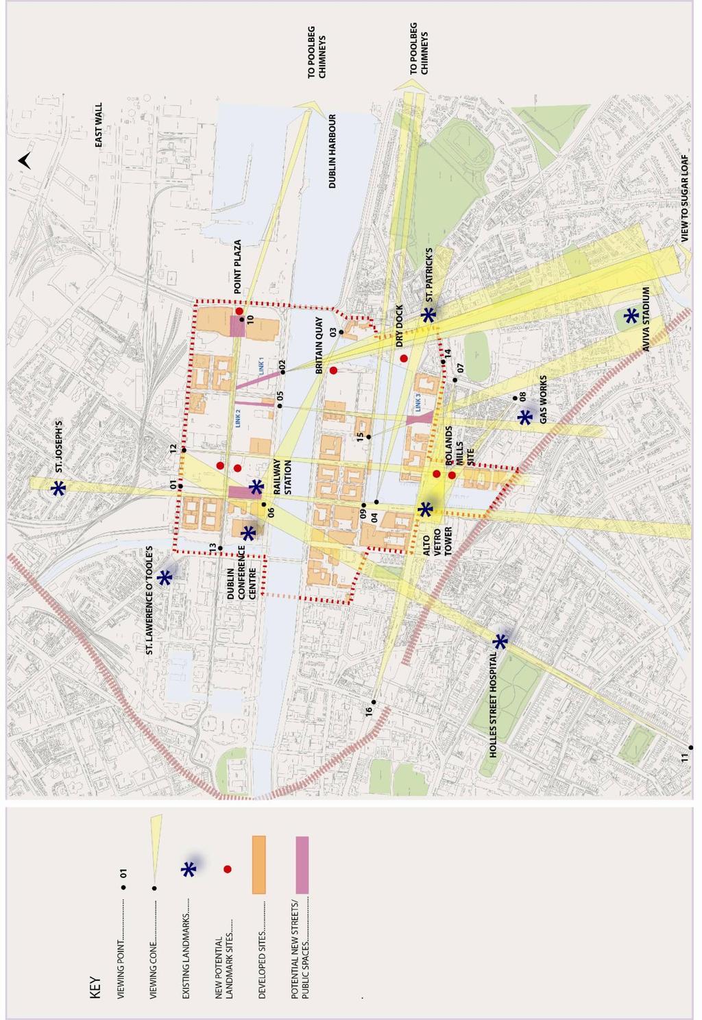
2 1.0 AIM OF STUDY The aim of the Views and Prospects study is to identify existing and potential views of landmark features in and around the Strategic Development Zone (SDZ), with a view to informing the layout (and height) of development on undeveloped lands in the SDZ. 2.0 METHODOLOGY The methodology used to identify views for protection in the SDZ involves four stages 1. Identification of the key landmark features within and in the areas surrounding the SDZ that contribute to its character and legibility. 2. Identification of the view types applicable to the area. 3. Identification of views to and from the landmark features into, out of and across the SDZ area both existing and potential. 4. Provision of detailed information on each view, including the viewing point/s, type of view, landmark features included in the view, its width, skyspace and backdrop. 3.0 LANDMARK FEATURES The features in and visible from this area include not only buildings and structures but natural and man-made landforms, such as the Grand Canal, the Grand Canal Dock, the River Liffey and the Dublin Mountains. The man-made features comprise a mix of historic and contemporary elements, which is characteristic of the area. Those elements that can be considered landmark features are important for two reasons and as such fall into one or both of the following categories (i) (ii) They are significant to the history and / or character of the area. They are physically conspicuous, by reason of their siting, design and / or height, and in this respect contribute to the legibility of the area and city as a whole. The key landmark features within and in the areas surrounding the SDZ include (see Map 1): Alto Vetro Tower Aviva Stadium Boland s Mills City Centre Montage (The Custom House, Liberty Hall & Dublin Spire) Dublin Conference Centre
 St. Patrick s Church Spire (Ringsend) The Gasworks Map 1 Key Landmark Features 4.")
3 Dublin Mountains Holles Street Hospital Old North Wall Railway Station Complex Poolbeg Generating Station Chimneys St. Joseph s Church Tower (East Wall) St. Laurence O` Toole Church (Seville Place) St. Patrick s Church Spire (Ringsend) The Gasworks Map 1 Key Landmark Features 4.0 VIEW TYPES The view types applicable to the area are (i) (ii) (iii) Vista a linear view, with corridor-type defined edges, usually with a singular landmark feature as its focal point. Broad Prospect a relatively wide view, often containing a number of landmark features. Contained Prospect a more contained / restricted view, with a defined edge, often containing a number of landmark features.
4 5.0 EXISTING & POTENTIAL VIEWS
5 5.1 Alto Vetro Tower The design, location, form and height of this building renders it one of the most notable in the area, characterising both the area s image and providing legibility. It is not visible however, from many locations within the SDZ, often being hidden by other tall structures such as the Millennium Tower to its northeast and Boland s Mills to its southeast. From Upper Sheriff Street the tower forms the subject of a vista which is contained by the buildings fronting Forbes Street (View 1). This view also includes the rear elevation of the old North Wall Railway Station and a backdrop of the Dublin Mountains. This north-south arterial, which passes through both the Grand Canal Plaza in the south docks and the proposed Railway Square south of Upper Mayor Street in the north docks, is an important link between the two emerging city neighbourhoods either side of the river. In fact, within this viewing corridor, the Alto Vetro tower is visible from within the proposed Station Square between the two low hipped roofs of the old Railway Station, providing an important visual link between the two areas. As View 1 moves south it opens out, with the view from Forbes Street incorporating the Grand Canal Plaza as a foreground to the Alto Vetro Tower. View 1 From Sheriff Street Bridge View 1 From Station Square A view of the tower over the low-rise residential area to the east of Boland s Mills is taken from Hastings Street (View 7). Long-range views of the building are also taken from the east, over the top of the northern part of Boland s Mills, viewed from the western end of Bridge Street (View 14) and from the west, along Pearse Street (View 16). It is considered that any re-development of the Boland s Mills site should seek to protect the skyspace around the top of the Alto Vetro Tower, as such, these views are discussed in detail in the Boland s Mills section below.

.")
6 5.2 Aviva Stadium There are limited views of this building at present from within the SDZ. As one of the city s most visually striking contemporary buildings, it is considered important to retain and to seek to enhance existing views of it, not only in terms of its contribution to the visual amenities of the area but also as an aid to legibility. A view of the eastern side of the stadium is visible along the mouth of the River Dodder from the north quays (View 2). View 2 From North Wall Quay View 15 From Hanover Quay From the south docks a view of the stadium is visible from the north side of the Grand Canal Basin on Hanover Quay (View 15). This view is visible across the western part of the bus depot site on Ringsend Road. The line of this view crosses View 5 (see Dublin Mountains section below). It is suggested that a clearer framed view of the stadium from Hanover Quay could be created by containing the view on its east side by a new building and by introducing a new, potentially triangularshaped public plaza on the western part of the bus depot site, fronting onto Ringsend Road. Such a view would not only visually enhance the area but would aid legibility. 5.3 Boland s Mills Long distance views of the Boland s Mills site are taken along New Wapping Street in the north docks, continuing along Blood Stoney Road in the south docks (View 12). These roads create a vista, with the northern elevation of the Boland s Mills complex in the foreground, set in front of the Monte Vetro building on Barrow Street. In most close-up views the Mills buildings appear bulky due to their relatively long north-south elevation, when viewed from the north however, they appear quite slender, in particular, when viewed against the backdrop of the Monte Vetro building. This vista would benefit from visual punctuation a light-coloured slender element on the Boland s Mills site could form a prominent feature against the backdrop of the Monte Vetro complex. The width of this vista is such that two such

; in fact, visually, the two")
7 elements could potentially be accommodated on the site. The specific location of any tall element/s should be informed by more close-up views of the Mills site, in particular, those to the east and west, which also include views of the Alto Vetro Tower (i.e. Views 14 & 16). View 12 From Mayor Street View 12 From North Wall Quay Along Hastings Street both the Mills buildings and the Alto Vetro Tower appear next to each other (View 7 below); in fact, visually, the two buildings appear joined together. From this viewpoint it is important to physically distinguish the buildings by introducing a skyspace around the top seven floors of the Alto Vetro Tower. Due to the low level of the houses in the foreground, any future slender element/s on the Mills site would be visible from this viewpoint. While the creation of a vista along this street, with a slender element centred on the northernmost of the existing tall elements on the Mills site, would work well from this viewpoint, such an element would conflict with the skyspace around the Alto Vetro Tower when viewed from the west (View 16). The skyspace around the Alto Vetro Tower from the west would be protected by focusing any new slender elements on either, or both, of the other two existing tall elements on the site (i.e. the middle and southernmost elements). When approaching the western end of Bridge Street both Boland s Mills and the Alto Vetro Tower swing into view, this time visually set apart (View 14). From this view the top seven storeys of the Alto Vetro Tower are currently visible, with a skyspace all around the latter, rendering it a striking feature in the streetscape. It is important that this definition is retained. A view of the tower-like element in the southeast of the Mills complex is visible along South Dock Street, slightly off-centre with the line of the road. While again, the creation of a vista along this road may be desirable (by siting a tall element in line with its centre), such an option is restricted due to position of protected structures on the site.
. This view also includes a glimpse of one of the limestone warehouses on the site, fronting onto Grand Canal Dock.")
8 View 7 Along Hastings Street View 16 Along Pearse Street View 14 From Bridge Street View 8 Along Gordon Street The tower-like element in the south-eastern corner of the site appears again in a view along Gordon Street (View 8). This view also includes a glimpse of one of the limestone warehouses on the site, fronting onto Grand Canal Dock. This view gives the impression of a pedestrian link through the space and on to the dock beyond. It is suggested that any re-development of the Mills site should seek to retain and potentially widen this view of the warehouses. 5.4 City Centre Montage & St. Laurence O Toole s Church Views of St. Laurence O Toole s Church are visible along Upper Sheriff Street and Spencer Dock. In addition, the view from Samuel Beckett Bridge of the Custom

9 House, Liberty Hall & Dublin Spire is arguably one of the best in the city of this group of features. While the above are viewed from within the study area there are no substantial development lands in the SDZ between those features and the viewing points, as such, their inclusion in this study is not considered necessary taking into account the stated aim of the study, i.e. to inform the layout (and height) of development on undeveloped lands in the SDZ. 5.5 Dublin Conference Centre A striking contemporary feature, this building is highly visible along the quays, in particular at night, when its glass cylinder is lit-up with coloured lighting, as such, it provides a good landmark / geographical reference point. As one of the most recognisable buildings on the north quays, it is considered that a view of it should be maintained from the west end of York Road on the eastern side of the mouth of the River Dodder / Grand Canal (View 3). The focus of this view would be improved by containment on its south side by a new building appropriately set-back on the corner of Britain Quay. Retention of this view would both aid legibility and provide a visual link between the established residential area of Ringsend on the south side and the emerging neighbourhood on the north side of the river. View 3 From York Road View 5 From North Wall Quay
.")
10 5.6 Dublin Mountains While views of the mountains are important and anchor the city in its landscape, their visual impact is generally limited due to the flattened profile of the mountain range. One view taken from the area however, frames the iconic and easily recognisable silhouette of the Sugarloaf Mountain (View 2 discussed above). This view, taken from the north quays along the mouth of the River Dodder is framed by the terraces of O Rahilly House Flats on its east side and the Aviva Stadium on its west side which channel the view, creating a vista terminated by the mountain. The composition and various elements included in this view render it arguably the most interesting in the area. As such, it is suggested that its line be extended northwards, by creating a new diagonal north-south link road between Upper Mayor Street and North Wall Quay (Link 1). Such a link would create a view experience when travelling southwards from Mayor Street, with the initial view being a visa of the Sugarloaf, contained by the new buildings either side of the new link, which would then open out moving southwards to finally reveal the broad vista currently visible from North Wall Quay. Many of the new streets created in the south docks frame views of the Dublin Mountains in the form of vistas, in particular, when viewed from the river / north quays. Those views that do, or that have the capacity to run through from the north quays are proposed for protection (Views 1 & 5). View 1 has been discussed above. Retention of View 5 would require the provision of two new north-south link roads, one between Upper Mayor Street and North Wall Quay in the north docks (Link 2) and one between Charlotte Quay and Ringsend Road in the south docks (Link 3). 5.7 Holles Street Hospital Holles Street Maternity Hospital on Mount Street lies at the end of what is known as The Georgian Mile. This view is included as one of the Key Views and Prospects in the Dublin City Development Plan The vista from Leeson Street along Fitzwilliam Place and Fitzwilliam Street is closed by the hospital building (View 11 - right). The issue with regard to the SDZ is the impact that any high buildings in the SDZ could have on the sky-space above this building. The area in the SDZ that is affected by this view runs in an approximately diagonal line from the southwest corner of the old Railway Station on the north quays, to the

11 junction of New Wapping Street and Upper Sheriff Street and westwards of that line encompassing the majority of the block containing the old Railway Station and the block to its north (see Map 3). Map 3 Area affected by View 11 Figure 1 shows a cross-section of the view corridor from Leeson Street to Holles Street Hospital, extrapolated beyond the building as far as Upper Sheriff Street. The cross-section indicates that, with a ground floor level of metres in the affected area (generally marked with an x ), a height of up to approximately 56 metres may be achieved without the structure coming in to view above Holles Street hospital when viewed along the Georgian Mile. It is recommended that any proposals for development in this part of the SDZ be required to provide detailed information, including photomontages, to demonstrate that they would not invade the skyspace above the Holles Street building. Figure 1 Cross Section of View 11
12 The areas to the north and east of the proposed Station Square are two potential sites for new tall buildings, i.e. (i) directly to the north of the existing two-storey terraced houses on Upper Mayor Street; and (ii) in the northeast corner of the block on the south side of Upper Mayor Street. View 1, which also traverses this part of the SDZ from north to south, may also potentially impact on future development if retained. It is suggested that Station Square, which is currently proposed as being square in shape, be rectangular the space lost on its east side being replaced by extending the square southwards as far as the rear wall of the old North Wall Railway Station. The benefits of such a change in shape would be: Increased daylight and sunlight into the new plaza the only buildings to its south, southeast and southwest would be very low-rise and would thus facilitate sunlight into the plaza, even in winter months. Retention of the character of the former red brick railway buildings and limestone wool store by using them to provide an edge to the public space / increasing views of them in the area in general i.e. the station building to the south and wool store along the eastern boundary of the new plaza. A more human-scale to the plaza. Protection of View 1 from Upper Sheriff Street to the Alto Vetro Tower (via a courtyard development on the block to the north of the plaza). A glimpse of the Alto Vetro Tower would also be visible from within the plaza, thus providing a visual link between the plazas on the north and south sides of the area. 5.8 Old North Wall Railway Station & Railway Hotel As stated above, the old North Wall Railway Station and Hotel are relatively low-rise red brick protected structures that front the north quays. It is these attributes, their height, colour and use of materials that render them visually conspicuous when viewed from both the north and south quays. View 3, taken from the west end of York Road on the east side of the mouth of the River Dodder / Grand Canal Dock provides an interesting contrast between the old, low-rise, red brick buildings of the railway complex and the modern, high-rise, curved glass façade of the Dublin Conference Centre. This view is discussed above, as is View 1, from which the rear elevation of the buildings are viewed from Upper Sheriff Street bridge and, potentially, from the proposed Station Square. 5.9 Poolbeg Generating Station Chimneys Arguably the most iconic structures in the city, these chimneys are visible from all over the city and for a considerable distance beyond. While the future of the chimneys may not be secure (a proposal to have them designated as protected

.")
13 structures was rejected by Dublin City Council in 2008), it is possible that should they be removed, their site could be redeveloped at some point in the future with a similarly striking landmark feature. A number of views of the chimneys exist from the area, three of which are proposed for protection. Arguably the most striking view is the long vista westwards through the south docks, which starts at Cardiff Lane and extends along Misery Hill and then along the full length of Hanover Quay, at the end of which the chimneys are framed by buildings on both sides (View 9). Also from the south docks, a broad and long-range view of the chimneys is taken from the Grand Canal Plaza over the Grand Canal Dock (View 4). The silhouette of the chimneys along with the spire of St. Patrick s Church on Bridge Street provide interest to an otherwise low-lying skyline. These features are situated to either side of the view and are of a similar form, being tall and slim and, from this view point, are similar in height. In terms of new development, it is suggested that the skyline may benefit from an additional landmark feature between the two, located at some point on the site of the old dry docks. Such a building could potentially be a relatively low-lying form with an interesting silhouette, and / or a building incorporating a tall element. View 9 Along Hanover Quay View 10 From The Point Plaza
14 View 4 From Grand Canal Plaza From the north docks the chimneys appear prominent from the Point plaza. The provision of a new landmark building on the eastern side of the plaza would provide a contained prospect of the chimneys between it and the rear wall of the Point Theatre (View 10) St. Joseph s Church (East Wall) A view of the tower of this church is visible from the corner of North Wall Quay and the southwest corner of the old Railway Station building (View 6). The vista is also visible from the north-western corner of the proposed Station Square on the south side of Upper Mayor Street. It is anticipated that new buildings on the east side of the block to the north of Station Square will contain and focus this view on the church and its tower. View 6 From North Wall Quay
15 As one of the few visible indicators of the proximity of the residential area of East Wall, it is important that this view be retained, both in terms of the character of the area and as an aid to legibility St. Patrick s Church (Ringsend) The spire of this church is visible from a number of places in the area, most notably from the north docks along the mouth of the River Dodder (View 2) and from the Grand Canal Dock Plaza (View 4) The Gasworks Like the Aviva Stadium, this building is visually spectacular. It has a relatively low profile however which, combined with its location on the edge of the SDZ, means that there are limited quality views of it from within the docklands area. An existing vista of The Gasworks, created by new development on the south quays, incorporates a long-distance view of the west side of the building (View 5). The link / plaza suggested above (see Aviva Stadium), between Charlotte Quay and Ringsend Road, may provide a more close-up view of this building from Hanover and / or Charlotte Quays. 6.0 IMPACT ON BUILT FORM Assessment of the existing and potential views in the area has identified a number of potential alterations to the future layout of the area; these include: (i) (ii) Sites that may have the potential to accommodate new landmark and / or tall buildings; and Alterations to existing roads and public spaces and the provision of new link roads and public spaces. 6.1 Potential New Landmarks With regard to views and prospects, the study has identified the following sites as having the potential to accommodate new landmark and / or tall buildings 6.2 Potential New Link Roads & Public Spaces With regard to views and prospects, the study has identified the following potential alterations to the layout of the SDZ (see Map 4): New diagonal link road between Upper Mayor Street and North Wall Quay (Link 1). New perpendicular link road between Upper Mayor Street and North Wall Quay (Link 2). Revised shape to Station Square / the proposed plaza on Upper Mayor Street.
.")
16 New link between Charlotte Quay and Ringsend Road (Link 3). Additional triangular-shaped public plaza fronting Ringsend Road (incorporating Link 3). Map 4 Potential Impact of Views on Built Form
17 7.0 PROPOSED VIEWS IN DETAIL This section comprises a matrix summarising the views identified in the study and a datasheet for each view. The datasheet identifies the viewing point/s, type of view, landmark features included in the view, its width, skyspace and backdrop. A photograph and map for each view is also included. Figure 2 Views Matrix View Ref Viewing Point Broad Prospect Contained Prospect Vista Alto Vetro Tower Aviva Stadium Boland s Mills Dublin Conference Centre Dublin Mountains Holles St Hospital Old Railway Station & Hotel Poolbeg Chimneys St. Joseph s Church St. Patrick s Church The Gasworks Point Plaza Building (new) 1 Upper Sheriff Street Bridge etc 2 North Wall Quay 3 York Road 4 Grand Canal Plaza 5 North Wall Quay 6 North Wall Quay / Station Square 7 Hastings Street 8 Gordon Street 9 Cardiff Lane / Hanover Quay 10 The Point Plaza 11 Leeson St Lwr / Fitzwilliam Place 12 New Wapping Street 13 Mayor Street 14 Bridge Street 15 Hanover Quay 16 Pearse Street
18
19 View Ref. 01 Viewing Point/s Type of View Landmark Features Width Skyspace Upper Sheriff Street Bridge / Station Square / North Wall Quay / Sir John Rogerson s Quay / Forbes Street Vista & Broad Prospect Alto Vetro Tower / Old North Wall Railway Station / Dublin Mountains Defined by yellow lines The skyspace around the top five storeys of the Alto Vetro Tower should be protected. Ideally, the chimneys of the Old North Wall Railway Station should also be visible from Upper Sheriff Street to frame the view of the tower. Backdrop The protection area for this view extends beyond the Alto Vetro Tower.

20 View Ref. 02 Viewing Point Type of View Landmark Features Width Skyspace North Wall Quay Broad Prospect & Vista Dublin Mountains (Sugarloaf) / St. Patrick s Church / Aviva Stadium Defined by yellow lines The composition and silhouettes of the different elements in this view are important, as such, its entire skyspace should be protected. Backdrop The protection area for this broad prospect view extends beyond St. Patrick s Church spire and the Aviva Stadium. The protection area for the vista at the centre of the view extends as far as the Great Sugarloaf Mountain. This part of the protection area is significantly elevated above the urban area due to the raised height of the element being protected i.e. the profile of the upper part of the Great Sugarloaf Mountain. The base for this part of the backdrop is indicated by a red line.
 Contained Prospect Dublin Conference Centre / Old North Wall Railway Station & Hotel Defined")
21 View Ref. 03 Viewing Point Type of View Landmark Features Width Skyspace York Road (western end) Contained Prospect Dublin Conference Centre / Old North Wall Railway Station & Hotel Defined by yellow lines The skyspace around the Dublin Conference Centre should be protected. Backdrop The protection area for this view extends beyond the Dublin Conference Centre.

22 View Ref. 04 Viewing Point Type of View Landmark Features Width Skyspace Grand Canal Plaza Contained Prospect Poolbeg Chimneys / St. Patrick s Church Defined by yellow lines The skyspace around the Poolbeg chimneys and the tower and spire of St. Patrick s Church should be protected. Backdrop Notes The protection area for this view extends beyond St. Patrick s Church on its south side and as far as Poolbeg on its north side. In the event of a structure being located between the viewing point and the chimneys, it is important to retain a view of them that includes the contrast between the painted and unpainted concrete.

23 View Ref. 05 Viewing Point Type of View Landmark Features Width Skyspace North Wall Quay / Benson Street / Hanover Quay Vista Dublin Mountains / The Gasworks Defined by yellow lines The skyspace around The Gasworks should be protected, including the line of the Dublin Mountains beyond. Backdrop The protection area for this view extends beyond The Gasworks.

24 View Ref. 06 Viewing Point Type of View Landmark Features Width Skyspace North Wall Quay / Station Square Vista St. Joseph s Church Defined by yellow lines The skyspace around the tower of the church should be protected. Backdrop The protection area for this view extends beyond St. Joseph s Church.

25 View Ref. 07 Viewing Point Type of View Landmark Features Width Skyspace Hastings Street Contained Prospect Alto Vetro Tower / Boland s Mills Defined by yellow lines The skyspace around the top seven storeys of the Alto Vetro Tower should be protected. Backdrop The protection area for this view extends beyond the Alto Vetro Tower. Notes Should the Boland s Mills site be redeveloped skyspace around the top 7 storeys of the Alto Vetro Tower on its south side should be created.
26 View Ref. 08 Viewing Point Type of View Landmark Features Width Skyspace Gordon Street Contained Prospect Boland s Mills Defined by yellow lines The skyspace above the stone warehouse fronting Grand Canal Dock should be protected. Backdrop Notes The protection area for this view extends beyond the stone warehouse fronting Grand Canal Dock. Should the Boland s Mills site be redeveloped this view should be widened on its north side.

27 View Ref. 09 Viewing Point Type of View Landmark Features Width Skyspace Cardiff Lane / Hanover Quay Vista Poolbeg Chimneys Defined by yellow lines The skyspace around the Poolbeg Chimneys should be protected. Backdrop The protection area for this view extends beyond Poolbeg.
28 View Ref. 10 Viewing Point Type of View Landmark Features Width Skyspace The Point Plaza Contained Prospect Poolbeg Chimneys Defined by yellow lines The skyspace around the Poolbeg Chimneys should be protected. Backdrop The protection area for this view extends beyond Poolbeg.

29 View Ref. 11 Viewing Point Leeson Street Lower / Fitzwilliam Place / Fitzwilliam Square East / Fitzwilliam Street Upper / Merrion Square East Type of View Landmark Features Width Skyspace Vista Holles Street Hospital Defined by yellow lines The skyspace above the terraces leading up to Holles Street Hospital and the skyspace around the hospital building itself should be protected. Backdrop The protection area for this view extends beyond the northern boundary of the SDZ.
30 View Ref. 12 Viewing Point Type of View Landmark Features Width Skyspace Sheriff Street Upper / Mayor Street / New Wapping Street / North Wall Quay / Blood Stoney Road Vista Boland s Mills Defined by yellow lines None at present. See Notes. Backdrop Notes The protection area for this view extends beyond the Monte Vetro building. This vista may be enhanced by one or two slender elements on the Boland s Mills site. Such elements would ideally pierce the skyspace above the Monte Vetro building, thus punctuating this long vista. Should such an element or elements be introduced, the skyspace around them should be protected.
 Defined by yellow lines The skyspace")
31 View Ref. 13 Viewing Point Type of View Landmark Features Width Skyspace Mayor Street Upper Vista Point Plaza Building (new) Defined by yellow lines The skyspace around the new building at the end of the vista should be protected. Backdrop The protection area for this view extends beyond the Point Plaza.
32 View Ref. 14 Viewing Point Type of View Landmark Features Width Skyspace Bridge Street Contained Prospect Alto Vetro Tower / Boland s Mills Defined by yellow lines The skyspace around the top seven storeys of the Alto Vetro Tower should be protected. Ideally, the tower would appear as a more isolated feature in the streetscape, with up to ten of its top storeys surrounded by skyspace. Backdrop The protection area for this view extends beyond Boland s Mills and the Alto Vetro Tower.

33 View Ref. 15 Viewing Point Type of View Landmark Features Width Skyspace Hanover Quay Contained Prospect Aviva Stadium Defined by yellow lines The skyspace around the Aviva Stadium should be protected. Backdrop The protection area for this view extends beyond the Aviva Stadium.

34 View Ref. 16 Viewing Point Type of View Landmark Features Width Skyspace Pearse Street Vista Alto Vetro Tower / Boland s Mills Defined by yellow lines The skyspace around the top five storeys of the Alto Vetro Tower should be protected. Ideally, the tower would appear as a more isolated feature in the streetscape, with up to twelve of its top storeys surrounded by skyspace. Backdrop The protection area for this view extends beyond Boland s Mills.
The Area has been divided into specific development zones with different characteristics and ownership patterns. These are identified on Diagram 1.
 2CONTEXT 7 2.1 THE AREA The Grand Canal Dock Planning Scheme Area (Area) comprises the lands framing the inner and outer basins of the GCD. The land covers 29.2 hectares (72.1 acres) and the inner and
North Lotts and Grand Canal Dock
 Proposed Amendments North Lotts and Grand Canal Dock Planning Scheme 2014 February 2018 w ww Comhairle Cathrach Bhaile Atha Cliath Dublin City Council North Lotts and Grand Canal Dock SDZ Planning Scheme
6.0 Development of Amenities,
 6.0 Development of Amenities, conservation of architectural heritage and other features This chapter outlines the Area's significant potential to provide for amenities of city wide and local importance
Diagram 6 Rail infrastructure showing proposed light rail system, Interconnector Line, new station and existing rail line at The Point
 NORTH SEVILLE PLACE Indicative Alignment of Underground Interconnector Line EAST ROAD 300 m 600 m GUILD STREET Proposed LUAS Light Rail Aligment 300 m Proposed LUAS Light Rail Aligment Docklands Station
The Master Plan also identified a number of issues and these issues remain and if anything have become more acute since 1997.
 Ringsend AAP Introduction Dublin Docklands Area Master Plan (the Master Plan) identified a number, of areas within Docklands where more detailed planning would be appopriate. One of those areas is the
Ringsend & Irishtown Local Environmental Improvement Plan
 Ringsend & Irishtown Local Environmental Improvement Plan Study Area East Link Bridge St. Patrick s Boat Club Ringsend Technical Institute Stella Maris Boat Club St. Patrick s Church Ringsend Library Ringsend
EVALUATION OF MASTER PLAN ALTERNATIVES
 7 The Environmental Report is required to identify, describe and evaluate reasonable alternatives, taking into account the objectives and geographical scope of the Master Plan 2008. Three plan alternatives
DUBLIN DOCKLANDS MASTER PLAN AND RELATIONSHIP WITH OTHER PLANS
 .1 National Policy and Programmes.1.1 Sustainable Development A Strategy for Ireland, 1997.1.2 National Climate Change Strategy, 2007-2012.1. National Development Plan 2007-201.1.4 National Spatial Strategy,
Yonge Eglinton Centre Urban Design Guidelines
 Yonge Eglinton Centre Urban Design Guidelines City Planning Urban Design January 2009 YONGE EGLINTON CENTRE INTRODUCTION.................................................... 1 GENERAL SITE PLAN OBJECTIVES......................................
Euston Area Plan. Background Report Appendix 3. Proposed modifications (shown as tracked changes)
") Euston Area Plan Background Report Proposed modifications (shown as tracked changes) September 2014 . Testing the impacts of tall buildings on strategic and local views Introduction This appendix provides
Euston Area Plan Background Report Proposed modifications (shown as tracked changes) September 2014 . Testing the impacts of tall buildings on strategic and local views Introduction This appendix provides
Page 1 of 19 URBAN DESIGN FRAMEWORK FOR BOLTON STREET WATERFORD
 Page 1 of 19 URBAN DESIGN FRAMEWORK FOR BOLTON STREET WATERFORD 1.0 Introduction: The relocation of the City Council stores and depot from Bolton Street creates an exciting opportunity for development
5. Bankside and The Borough 5.1. Bankside and The Borough Area Vision
 5. 5.1. Area Vision 5.1.1. are: A globally significant central London business district which is home to international business headquarters; At the heart of the commercial and cultural life of the capital
The impacts examined herein take into account two attributes of aesthetic values:
 IV. ENVIRONMENTAL IMPACT ANALYSIS This section addresses the potential impacts to views and aesthetics as a result of the proposed Project at the Project Site and the development scenarios analyzed for
URBAN DESIGN BRIEF URBAN DESIGN BRIEF 721 FRANKLIN BLVD, CAMBRIDGE August 2018
 URBAN DESIGN BRIEF URBAN DESIGN BRIEF 721 FRANKLIN BLVD, CAMBRIDGE August 2018 DESIGN BRIEF CONTENTS PART A 1.0 INTRODUCTION 2.0 DESCRIPTION & ANALYSIS OF SITE CONTEXT 3.0 DESIGN CONSTRAINTS AND OPPORTUNITIES
PROJECT SITE The Proposed Project includes the Allen and Pike Street malls between Delancey and South Streets (see Figure 2C-1).
.") Chapter 2, Section C: A. INTRODUCTION This chapter considers the potential of the proposed Reconstruction of the Allen and Pike Street Malls project to affect the urban design characteristics and visual
Chapter 2, Section C: A. INTRODUCTION This chapter considers the potential of the proposed Reconstruction of the Allen and Pike Street Malls project to affect the urban design characteristics and visual
3.3. Urban Structure Defining a New Hierarchy of Routes and Spaces >Images
 Section 3.0 I The Masterplan Framework 18 >Images Examples of high quality routes and spaces 3.3. Urban Structure The success of any masterplan lies in a clear definition of the future urban structure
heuston gateway: sections heuston gateway: regeneration strategy and development framework plan
 B B1 A B1 B C A heuston gateway: sections B B1 C 117 4.3.3 Zoning The station is the central hub of the area and this function must be preserved and developed. However large areas of the Heuston Station
Nature and Extent of Proposed Development
 163 Chapter 5 5.1 Introduction The preceding Chapter 4 sets out the high-level themes (including the Framework for a Sustainable Dublin), the key structuring principles, and the key building blocks, together
WATERFRONT PLACE CENTRAL MIXED USE REDEVELOPMENT PROJECT
 WATERFRONT PLACE CENTRAL MIXED USE REDEVELOPMENT PROJECT View Impact Analysis - Summary Narrative The view impact analysis conducted for the Waterfront Place Central mixed-use redevelopment project proposal
6. Bermondsey 6.1. Bermondsey Area Vision
 6. 6.1. Area Vision 6.1.1. is: An inner-london neighbourhood characterised by modest worker ho associated with the historic Rotherhithe docks and local manufacturing industries such as biscuits, jam, vinegar
BORRISOKANE SETTLEMENT PLAN
 BORRISOKANE SETTLEMENT PLAN 1.0 General Introduction and Development Context Location Borrisokane is located 15km north of Nenagh on the N52. While the town is primarily residential, it acts as a market
28. Coolaney-Rockfield Mini-Plan
 28. Coolaney-Rockfield Mini-Plan 28. Coolaney-Rockfield Mini-Plan Community facilities Community facilities in Coolaney-Rockfield consist of a primary school, crèche, community centre, sports field and
SITE ANALYSIS CALVARY HOSPITAL NORTH ADELAIDE LARGE INSTITUTIONS AND COLLEGES DPA CALVARY HOSPITAL
 SITE ANALYSIS Located at: 81-100 Strangways Terrace 55-79 Barnard Street 2-34 Hill Street 312-320 Ward Street HISTORY The Calvary Hospital was established in 1900 and is one of Adelaide's oldest hospitals.
Environmental Impact Statement
 Environmental Impact Statement of Development Proposals contained in the Planning Scheme for Docklands North Lotts August 2001 IRE 5.00 CONTENTS Non Technical Summary 1.0 INTRODUCTION 1 1.1 Background
Tall Buildings Strategy
 Chapter 8 Tall Building Strategy Mayor of London 115 existing & consented tall buildings effect on views of palace of westminster Chapter 8 Tall Buildings Strategy tall building cluster upto 150m with
2.0 Strategic Context 4
 2.0 Strategic Context 4 2.1 The Area Action Plan is a non-statutory plan, which forms a corporate policy document, expressing particular issues and areas of concern while also providing a vision for the
Urban Design Brief December 23, 2015 Southside Construction Group Official Plan & Zoning By-Law Amendment
 Urban Design Brief Proposed Official Plan & Zoning By-Law Amendment 3244, 3263 and 3274 Wonderland Road South Southside Group December 23, 2015 TABLE OF CONTENTS Page No. INTRODUCTION... 1 SECTION 1 LAND
4.00 STAKEHOLDERS. urbanprojects
 4.00 STAKEHOLDERS 94 heuston gateway: regeneration strategy and development framework plan 95 The Heuston Gateway presents one of the greatest concentrations of brown field development sites located adjacent
PART 05 VISUAL SETTING
 PART 05 VISUAL SETTING 5.1 How to use the Visual Settings 5.2 Views from the Headland 5.3 Creek Foreshore Park Looking North 5.4 Bridge looking North 5.5 Bridge looking West 5.6 Bridge looking South 5.7
Official Plan Amendment to Further Protect Heritage Views of City Hall, Old City Hall and St. James Cathedral - Preliminary Report
 STAFF REPORT ACTION REQUIRED Official Plan Amendment to Further Protect Heritage Views of City Hall, Old City Hall and St. James Cathedral - Preliminary Report Date: June 6, 2017 To: From: Toronto and
Site 2 Development Brief
 a South Marketgait Site 2 b Union Street c Site 2 Development Brief Thomson Avenue (Northern Boulevard) Dundee Riverside Drive Discovery Plaza South Union Street Station Earl Grey Place West Site 5 Site
Lancaster Conservation Area Appraisal. Character Area 8. Cathedral
 Lancaster Conservation Area Appraisal Character Area 8. Cathedral March 2013 118 3.8 Character Area 8. Cathedral 3.8.1. Definition of Special Interest "This character area is distinctive for the fine group
Chapter 7: Landscape and Visual Impact Assessment
 Chapter 7: Landscape and Visual Impact Assessment Landscape Character and Visual Impact Assessment 7. Landscape Character and Visual Impact Assessment... 2 7.1 Methodology... 2 7.2 Assessment Findings...
I539. Smales 2 Precinct
 I539. Smales 2 Precinct I539.1. Precinct Description The Smales 2 Precinct applies to a 4.8 hectare block of land located on the southern side of Northcote Road and fronting Lake Pupuke, Takapuna. The
Chapter 5 Urban Design and Public Realm
 5.1 Introduction Public realm is all areas of the urban fabric to which the public have access. It is where physical interaction takes place between people. It therefore, includes buildings and their design,
Urban Design Brief. Watson Parkway North & Watson Road North Guelph, Ontario. Prepared by Coletara Development
 Urban Design Brief Watson Parkway North & Watson Road North Guelph, Ontario Prepared by Coletara Development December, 2013 Urban Design Brief, Coletara Development 1 Introduction This Urban Design Brief
20. Ballysadare Mini-Plan
 20. Ballysadare Mini-Plan 20. Ballysadare Mini-Plan Community facilities Ballysadare has a wide range of community facilities: a primary school, St Mary s College (secondary school), a health centre, playing
APPENDIX A: Kilternan Neighbourhood Framework Plan
 APPENDIX A: Kilternan Neighbourhood Framework Plan 95 www.dlrcoco.ie Kilternan Neighbourhood Framework Plan January 2010 dlr Architects Department dlr Planning Department Contents: Kilternan Neighbourhood
Appendix B Figures L1 and L2 - Townscape Analysis
 The Derriford Transport Scheme WEBTag Townscape and Visual Impact Appraisal (WTVA) Appendix B Figures L1 and L2 - Townscape Analysis J:\29210 Plymouth City Modelling\Technical\Landscape\Reports\29210_De
burlington mobility hubs study Downtown Burlington Mobility Hub
 burlington mobility hubs study Downtown Burlington Mobility Hub Draft Precinct Plan Workbook PIC #3, September 7, 2017 downtown mobility hub objectives City staff and their consultants are proposing an
Colchester Northern Gateway Master Plan Vision Review Draft. July 2016
 Colchester Northern Gateway Master Plan Vision Review Draft July 2016 Contents Introduction 4 Context 8 Purpose of the Report 8 Strategic Position 9 Overview of the Process 11 2012 Master Plan Vision 12
4 RESIDENTIAL ZONE. 4.1 Background
 4 RESIDENTIAL ZONE 4.1 Background The residential areas within the City are characterised by mainly lowrise dwellings sited on individual allotments. Past architectural styles, settlement patterns and
TALL BUILDING GUIDELINES
 TALL BUILDING GUIDELINES Urban Design Guidance for the Site Planning and Design of Tall Buildings in Milton May, 2018 A Place of Possibility Contents 1.0 INTRODUCTION 1 1.1 What is a Tall Building? 2
B. PROPOSED REFINEMENTS POTENTIALLY AFFECTING URBAN DESIGN AND VISUAL RESOURCES
 Chapter 4: Urban Design and Visual Resources A. CONCLUSIONS OF THE FGEIS The FGEIS concluded that the Approved Plan will not result in any significant adverse impact on urban design or visual resources.
Chapter 11 Landscape and Visual
 Chapter 11 Landscape and Visual Chapter 11 Landscape and Visual 11.1 Introduction Murray & Associates conducted the landscape and visual assessment for the proposed. The proposed site is located in Waterford
URBAN DESIGN FRAMEWORK
 URBAN DESIGN FRAMEWORK 6 6 URBAN DESIGN FRAMEWORK HANOVER QUAY APARTMENTS 142 URBAN DESIGN FRAMEWORK 6 6.1 INTRODUCTION Sustainable development, defined by the Brundtland Commission in 1983 as development
Artists impression of the Park Promenade and plot H4 with café and restaurant uses that is still subject to change
 The Park Promenade Artists impression of how a café might look Artists impression of the Park Promenade and plot H4 with café and restaurant uses that is still subject to change Precedent images for balconies
30. Riverstown Mini-Plan
 County Development Plan 2017-2023 Consolidated Draft + Adopted Amendments August 2017 Volume 2, Chapter 30 Riverstown Mini-Plan 30. Riverstown Mini-Plan Village profile Riverstown is located approximately
3.0 Area-Wide Strategies 30
 3.0 Area-Wide Strategies 30 3.6 Tourism Strategy This section of the plan aims to develop and improve the tourism potential of the area. Strategic Context The City Plan outlines the potential of Cork to
Site 5 Development Brief
 Union Street Crichton Street South Crichton Street Thomson Avenue (Northern Boulevard) Site 5 South Union Street Earl Grey Place West Site 6 Riverside Esplanade (Southern Boulevard) South Crichton Street
17. Coolaney-Rockfield Mini-Plan
 County Development Plan 2017-2023 Consolidated Draft + Adopted Amendments - August 2017 17. Coolaney-Rockfield Mini-Plan Village profile Coolaney is located approximately 23 km to the south-west of Sligo
401/Keele Provincial Campus Ontario Realty Corp.
 1.0 INTRODUCTION 1.1 Site Location and Description The study area consists of approximately 74 acres (30 ha) located in the Keele Street and Wilson Avenue area. It is bounded by Wilson Avenue to the north,
PLANNING JUSTIFICATION REPORT
 PLANNING JUSTIFICATION REPORT 55 DELHI STREET CITY OF GUELPH PREPARED FOR: VESTERRA PROPERTY MANAGEMENT PREPARED BY: LABRECHE PATTERSON & ASSOCIATES INC. SCOTT PATTERSON, BA, CPT, MCIP, RPP PRINCIPAL,
GUIDELINES WESTON LOCATION: URBAN DESIGN GUIDELINES
 Development in the Weston area will be consistent with the following urban design guidelines. The guidelines correspond to Site and Area Specific Policies 45, 46, 47, 48, 49, 51, 52 and 232 in Chapter
Poolbeg West SDZ Draft Planning Scheme
 Poolbeg West SDZ Draft Planning Scheme Introduction/vision Housing Community Economy/Employment Movement/transport Infrastructure green infrastructure /open space Land-use and phasing Public Realm Urban
Regency Developments. Urban Design Brief. Holyrood DC2 Rezoning
 Regency Developments Urban Design Brief Holyrood DC2 Rezoning Stantec Consulting Ltd. 7-31-2017 1. Overview Regency Developments intends to rezone the lands located at 8510 and 8511 93 Avenue, within the
COURTHOUSE CAMPUS BARNSLEY Executive Summary March 2010
 COURTHOUSE CAMPUS BARNSLEY Executive Summary March 2010 Estell Warren Cartwright Pickard Buro Happold King Sturge BWA Barnsley Metropolitan Borough Council introduction Courthouse Campus is the last major
GREENFORD HALL & ADJOINING LAND
 GREENFORD HALL & ADJOINING LAND CONTENTS 1. Introduction 1. Introduction 2. Urban Context 2.1 The Site and Surroundings 2.2 Urban Context Map 2.3 Access and Movement 3. Planning Context 3.1 Planning History
Environmental and Landscape Mapping
 Environmental and Landscape Mapping In support of the Calveley Neighbourhood Plan November 2016 Project Name and Number: Calveley Neighbourhood Plan 16-025 Document Name and Revision: Environmental and
I615. Westgate Precinct
 I615. Westgate Precinct I615.1. Precinct Description The Westgate Precinct is located approximately 18km west of the Auckland city centre. There are seven Sub-precincts in the Westgate Precinct: Sub-precinct
IV. ENVIRONMENTAL IMPACT ANALYSIS B. AESTHETICS 1. VIEWS
 IV. ENVIRONMENTAL IMPACT ANALYSIS B. AESTHETICS 1. VIEWS ENVIRONMENTAL SETTING Existing Visual Character Project Site The project site is located at 10250 Wilshire Boulevard in the Westwood community of
Workshop 3. City of Burlington Waterfront Hotel Planning Study. September 14, The Planning Partnership
 Workshop 3 City of Burlington Waterfront Hotel Planning Study September 14, 2017 The Planning Partnership The Waterfront Hotel Planning Study 01 The Brant & Lakeshore Planning Study will establish a Strategic
PUTTING THE HEART INTO BATTERSEA. A vision
 PUTTING THE HEART INTO BATTERSEA A vision INTRODUCTION This document is a vision for creating a Battersea that its community can be proud of and it is about putting Battersea on the map. It is being proposed
Garden Bridge Planning Application
 Planning Application Additional Verified photomontages and assessment September 2014 Contents Page 1 Visual assessment 2 1.1 Introduction 2 1.2 Baseline 2 1.3 Potential effects and good environmental
ENVIRONMENTAL AND LANDSCAPE MAPPING
 APPENDIX IV : Environmental and Landscape Mapping ENVIRONMENTAL AND LANDSCAPE MAPPING Calveley Neighbourhood Plan November 2016 ENVIRONMENTAL AND LANDSCAPE MAPPING Calveley Neighbourhood Plan Calveley
16. Peckham Peckham Area Vision
 16. 16.1. Area Vision 16.1.1. is: A lively town centre providing a range of daytime and night time activities on Rye Lane including a Library, a Leisure Centre and many independent retailers which specialise
URBAN DESIGN BRIEF Gordon Street City of Guelph. Prepared on behalf of Ontario Inc. March 25, Project No. 1507
 URBAN DESIGN BRIEF 1131 Gordon Street City of Guelph Prepared on behalf of 1876698 Ontario Inc. March 25, 2016 Project No. 1507 423 Woolwich Street, Suite 201, Guelph, Ontario, N1H 3X3 Phone (519) 836-7526
Housing Land Initiative. Feasibility Study. Update
 Report to the Housing & Community Strategic Policy Committee Housing Land Initiative Feasibility Study Update September 2016 Oscar Traynor Road Site Site Description Dublin City Council owns a 17.014 ha
Proposed Illustrative Masterplan Cumulative Revised Proposals. Properties
 Proposed Illustrative Masterplan Cumulative Revised Proposals Earls Court Project Application 2 Royal Borough of Kensington & Chelsea Environmental Statement, Volume II - Site Wide Development Option -
420 FANSHAWE PARK ROAD EAST London, ON
 420 FANSHAWE PARK ROAD EAST London, ON URBAN DESIGN BRIEF, CHARACTER STATEMENT & COMPATIBILITY REPORT April 2016 Prepared by MHBC Planning 630 COLBORNE STREET SUITE 202 LONDON, ON N6B 2V2 TABLE OF CONTENTS
15.0 EFFECT ON THE ENVIRONMENT: Sunlight
 15.0 EFFECT ON THE ENVIRONMENT: Sunlight 15.1 Introduction 15.1.1 ARC Architectural Consultants Ltd has been retained to carry out an analysis of the shadows likely to be cast by the proposed structures
(DC1) Direct Development Control Provision DC1 Area 4
 Direct Development Control Provision DC1 Area 4") . General Purpose (DC) Direct Development Control Provision DC Area 4 The purpose of this Provision is to provide for an area of commercial office employment and residential development in support of the
. General Purpose (DC) Direct Development Control Provision DC Area 4 The purpose of this Provision is to provide for an area of commercial office employment and residential development in support of the
5.0 P A R K R E C O M M E N D A T I O N S
 5.0 P A R K R E C O M M E N D A T I O N S 5.1 Confederation Park The analysis of Confederation Park recognizes that it, along with City Hall, is the symbolic heart of Kingston. While the existing layout
Appraisal of proposed alterations to the boundary of Helmsley Conservation Area
 Appraisal of proposed alterations to the boundary of Helmsley Conservation Area Elmslac Road: Elmslac Road was constructed in the early 1950s in two or three stages by the Helmsley Rural District Council.
Introduction. Welcome to this consultation regarding the draft redevelopment proposals for the former CeramTec factory on Sidmouth Road, Colyton.
 Introduction Welcome to this consultation regarding the draft redevelopment proposals for the former CeramTec factory on Sidmouth Road, Colyton. We are currently considering options for the mixed-use redevelopment
8. Camberwell 8.1. Camberwell Area Vision
 8. 8.1. Area Vision 8.1.1. is: Centred on a medieval village centre which has become a thriving modern town centre surrounded by residential streets laid out in the Georgian era; Linked by rail to central
URBAN DESIGN BRIEF 305, 309, & 315 SOUTHDALE ROAD WEST LONDON ONTARIO
 URBAN DESIGN BRIEF 305, 309, & 315 SOUTHDALE ROAD WEST LONDON ONTARIO CARVEST PROPERTIES LTD. December 2013 Section 1 - Land Use Planning Context 1.1 Subject Lands The subject lands are located immediately
2154 Dundas Street West Intention to Designate under Part IV, Section 29 of the Ontario Heritage Act
 STAFF REPORT ACTION REQUIRED 2154 Dundas Street West Intention to Designate under Part IV, Section 29 of the Ontario Heritage Act Date: February 2, 2009 To: From: Toronto Preservation Board Toronto and
3.1 The hybrid planning application proposes the following description of development:
 CHAPTER 3: PROPOSED DEVELOPMENT 3.1 The hybrid planning application proposes the following description of development: Hybrid (part-outline/part-full) planning application for a single composite development
Re: Draft Planning Scheme 2013 for the North Lotts and Grand Canal Dock
 DRAFT SUBMISSION Re: Draft Planning Scheme 2013 for the North Lotts and Grand Canal Dock Dear Sir/Madam I wish on behalf of the North Port Dwellers Association of Unit C, Liffey Trust Centre, 117-126 Sheriff
Milford Shopping Centre Proposed Plan Change Assessment of Visual and Landscape Effects
 Milford Shopping Centre Proposed Plan Change Assessment of Visual and Landscape Effects LA4 Landscape Architects PO Box 5669, Wellesley Street Auckland Table of Contents 1.0 Introduction 3 2.0 The Proposed
Part D. College Avenue Campus PAGE 121 UNIVERSITY OF REGINA / CAMPUS MASTER PLAN 2011
 Part D College Avenue Campus UNIVERSITY OF REGINA / CAMPUS MASTER PLAN 2011 PAGE 121 PAGE 122 PREPARED BY / DIALOG Figure D-1. A view of the College Building at the College Avenue Campus in winter 11.0
Oscar Traynor Road Land Initiative Project
 Oscar Traynor Road Land Initiative Project Page 1 INTRODUCTION This report has been prepared as a follow up document to the Housing Land Initiative Feasibility Study presented to the joint Housing and
Town Center. Block 5 Existing multifamily residential units are expected to remain.
 Area Guidelines Germantown s districts should be developed as distinct communities with unique features that are supported through the guidelines. The guidelines not only help distinguish these districts
3.1.1 Heuston Square. heuston gateway: regeneration strategy and development framework plan. Heuston Gateway: public domain: Heuston Square location
 3.1.1 Heuston Square The space to the front of the Headquarters Building of the Great Western Railway is considered to be in the centre of the Heuston Gateway. All destinations in the area radiate from
public spaces and associated development
 4.0 Public Spaces and Associated Development The Guinness lands are adjacent to 3 of the principal public spaces of the Development Framework Plan for the Heuston Gateway as described below. 4.1 Heuston
SCHEDULE 12 TO THE DESIGN AND DEVELOPMENT OVERLAY GLEN WAVERLEY ACTIVITY CENTRE STRUCTURE PLAN
 DD/MM/YY Proposed C120 SCHEDULE 12 TO THE DESIGN AND DEVELOPMENT OVERLAY Shown on the planning scheme map as DDO12. GLEN WAVERLEY ACTIVITY CENTRE STRUCTURE PLAN 1.0 Design objectives DD/MM/YY Proposed
4.1 AESTHETICS AND VISUAL QUALITY
 SCOPE AND METHODOLOGY 4.1 AESTHETICS AND VISUAL QUALITY This section evaluates the potential impacts to aesthetics and visual quality. Aesthetics refers to visual resources and the quality of what can
UNIVERSITY TOWN NEIGHBOURHOODS 5.5 HOUSING MELBOURNE CAMPUS MASTER PLAN 2014
 5.5 169 EXISTING CONDITIONS & VISION NEIGHBOURHOOD VISION The provision of on-campus housing into the future will continue to be an important element of the La Trobe University experience. A long-term
Hampton Park North Littlehampton West Sussex
 North Littlehampton West Sussex SUMMARY Summary An opportunity to create a new community in West Sussex on the northern outskirts of Littlehampton with outstanding views across open countryside towards
REMARKABLES PARK ZONE
 .10 Remarkables Park Zone.10.1 Resources, Activities and Values The Remarkables Park Area comprises approximately 150 hectares of perimeter urban land in the vicinity of Frankton and occupies a strategic
URBAN DESIGN BRIEF 1435 Beaverbrook Road On behalf of Wonderland Commercial Centre Inc.
 URBAN DESIGN BRIEF 1435 Beaverbrook Road On behalf of Wonderland Commercial Centre Inc. Knutson Development Consultants Inc. Development Engineering (London) Ltd. K & L Construction and Arthur Lierman
A. The sites in Table 16 below, as identified on the Policies Map, are allocated for retail-led development:
 SWDP 44: Worcester City Centre A. The sites in Table 16 below, as identified on the Policies Map, are allocated for retail-led development: Table 16: Sites Allocated for Retail-Led Development Policy Reference
Urban Design Brief Proposed Residential Development 5219 Upper Middle Road City of Burlington
 Urban Design Brief Proposed Residential Development 5219 Upper Middle Road City of Burlington Prepared by Weston Consulting Prepared for BLOOMFIELD DEVELOPMENT INC. Date: March 2017 Table of Contents 1.
Chapter 2, Section C: Urban Design and Visual Resources A. INTRODUCTION
 Chapter 2, Section C: Urban Design and Visual Resources A. INTRODUCTION This attachment considers the potential of the proposed East River Waterfront Access Project at Peck Slip to effect urban design
ELMVALE ACRES SHOPPING CENTRE MASTER PLAN
 ELMVALE ACRES SHOPPING CENTRE MASTER PLAN Contents 1.0 INTRODUCTION... 2 2.0 LOCATION... 2 3.0 EXISTING CONTEXT... 2 4.0 VISION & GUIDING PRINCIPLES... 2 5.0 LAND USE AND BUILT FORM... 4 5.1 St. Laurent
Genex Kidston Connection Project: Draf t Environmental Assessment Report Powerlink Queensland
 : Draf t Environmental Assessment Report Powerlink Queensland Chapter 14 \\autsv1fp001\projects\605x\60577456\6. Draft Docs\6.1 Reports\4. Compiled draft 17 September\Covers\Chapters\Ch 14.docx Rev ision
taken from publically accessible locations within the been considered in this appraisal. These have been
 Visual Receptors 3.64 Visual receptors are people within the surrounding area whose views or visual amenity would be effected by the development proposals. 3.65 Visual receptors that will be most sensitive
Stanton Drew Parish Neighbourhood Plan Landscape and Environment
 Contents Introduction... 2 Scope of the Document... 2 Our Definition of a View... 2 Proposed Policies... 3 Criteria for a Protected View... 3 Views Assessed... 4 View 1: from cricket ground north towards
16. Collooney Mini-Plan
 16. Collooney Mini-Plan Village profile Collooney is located approximately 13 km to the south of Sligo City, in a designated Rural Area under Urban Influence. The village provides a range of services for