2018 Priority Regional Transportation Projects. Integrated Regional Transportation Master Plan
|
|
|
- Maximillian Elliott
- 5 years ago
- Views:
Transcription
1 2018 Priority Regional Transportation Projects June 14, 2018
2 Table of Contents 1.0 INTRODUCTION BACKGROUND OBJECTIVES METHODOLOGY OVERVIEW OF EVALUATION PROCESS PROJECT LIST EVALUATION CRITERIA POLICY AREA WEIGHTING PROJECT PRIORITIZATION PROJECT SCORING PROJECT PRIORITIZATION COMPLETED PROJECTS FUNDED AND/OR COMPLETED PROJECTS CONCLUSION AND RECOMMENDATIONS CONCLUSION RECOMMENDATIONS 17 FIGURES (Maps) FIGURE 1: PROJECTS READY FOR CONSTRUCTION 9 FIGURE 2: PROJECTS READY FOR DESIGN 12 FIGURE 3: PROJECT FUNCTIONAL PLANNING OR STUDY 15 APPENDICES APPENDIX A: MASTER PROJECT LIST APPENDIX B: REGIONAL ROADWAY AND TRANSIT PRIORITY LISTS Page 2
3 1.0 INTRODUCTION 1.1 Background The Edmonton Metropolitan Region Board (EMRB) approved the Integrated Regional Transportation Master Plan (IRTMP) in September 2011.The Plan defines key elements of the Region s future transportation system over a 35 year time frame. The IRTMP builds upon and supports the policy framework established in the Edmonton Metropolitan Region.The IRTMP also lists the 10-year roadway and transit investment priorities throughout the region. In order to help implement the IRTMP, the Edmonton Metropolitan Region Board supported the development of a shorter-term prioritization of the 10 year roadway and transit project list in The development of such a regional priority list was to foster coordination of regional transportation initiatives between municipalities, as well as to influence the Provincial Three Year Capital Plan towards better alignment with the Region s needs and priorities. The first transportation priorities report was completed in mid Based on its success the Board directed that the priorities be updated annually. This 2018 edition is the 5 th annual transportation priorities report. 1.2 Objectives The objectives of the IRTMP Transportation Priorities Project are: 1. To compile a listing of the EMRB s transportation priorities that would serve to coordinate the actions of member municipalities and the Province over the short term towards the longer term objectives of the Edmonton Metropolitan Region Growth Plan. 2. To include provincial transportation staff in the development of regional priorities to achieve better alignment of municipal, regional and provincial capital plans. 3. To develop a set of recommendations that will focus municipal and provincial attention and action on priority transportation initiatives by municipalities and the province in its Three Year Capital Plan. 4. To enable timely and rolling updates of regional priorities as conditions evolve over time. This document is intended to be a living document, which will be changed and improved in the future to meet and reflect changing conditions. Page 3
4 2.0 METHODOLOGY 2.1 Overview of Evaluation Process Representatives from all member municipal administrations and Alberta Transportation were invited to participate in the project prioritization process. In addition to representation from Alberta Transportation the following municipalities participated in the 2018 evaluation process: City of Edmonton City of Fort Saskatchewan City of Leduc City of Spruce Grove City of St. Albert Leduc County Parkland County Strathcona County Sturgeon County Town of Beaumont Town of Morinville Town of Devon Town of Stony Plain The following is a summary of the various stages of the regional transportation project prioritization process: 1. Reviewed and updated the Roadway and Transit Project List (Appendix A) Project must related to a Roadway or Transit Network as shown on Schedules 10A & 10B of Edmonton Metropolitan Region Growth Pan Roadway projects needed to be regionally significant Defined project status 2. Defined Evaluation Criteria Specific criteria that related to the IRTMP and Edmonton Metropolitan Region Growth Plan 3. Determined weighting of the evaluation criteria (Using pair-wise analysis) 4. Each project was scored against the agreed upon criteria and their weights 5. Determined project priority within based on status: high, medium or low 6. Adjusted project scoring Assigned numerical value to project priority Applied project priority factor to project score to arrive at adjusted score 7. Prioritized Regional Projects by project status Sorted project list by adjusted score to arrive at project ranking 2.2 Project List Regional projects that have been included on the Roadway and Transit Project List (Appendix A) reflect transportation infrastructure that is regionally significant. The IRTMP defines regionally significant roads as any arterial or higher order roadway that, regardless of jurisdiction, serves to Page 4
5 connect EMRB municipalities with each other and with other regions in Alberta and Canada. In the case of transit projects included on the list, they are projects of regional significance that support intermunicipal transit and a regional shift to transit. The original Ten Year project list from the IRTMP has been updated and expanded to include all regionally significant projects that are not only emerging but also those that are identified as important in achieving the long terms goals and objectives of the Edmonton Metropolitan Region Growth Plan. The Roadway and Transit Project List has grown from 36 projects in the 2014 Report to over 90 projects to date. New projects are added as they are identified, others were broken into segments to recognize phasing (i.e. Nisku Spine Rd., 41 st Ave., Etc.), and lastly projects are removed as they completed. The updated list of Roadway and Transit projects is presented in Appendix A. 2.3 Evaluation Criteria The evaluation criteria were originally developed in 2013/14 to help identify project priorities and select a list of projects that would be deemed to be of highest priority for the Region. For 2018 the evaluation criteria was reviewed, revised, and grouped to align with the policy areas of the newly updated Edmonton Metropolitan Region Growth Plan that was approved by the Province in October The new evaluation criteria is shown in Table 2.1 below. Table 2.1: Evaluation Criteria Note: For maps referred to in the table please refer to the Update to the Regional Transportation Priorities Evaluation Criteria Report 1. Economic Competitiveness & Employment Score Description of how scoring is applied a. Improves a major goods movement route 1 if it improves a major goods route. (See Map 1*) Note -HOV/Transit Priority, Park & Ride and LRT is rated 0 even if on route. b. Connects or provides direct access to a Major 1 if it is immediately adjacent to, within or provides direct access to a Employment Area in the EMRGP including transit Major Employment Area as identified on Map 2*. c. Improves a major commuter route as defined in EMRGP 1 if it is located on a regional road within the Commuter Shed as identified on Map 3*. d. Improves a high load/heavy load/long combination 1 if it improves an existing or potential high load corridor or long vehicle corridor combination vehicle route as identified on Schedule 10C* of EMGRP. e. Improves a major external economic corridor 1 if it improves a Hwy as depicted on Map 4*. Note - HOV/Transit Priority, Park & Ride and LRT is rated 0 even if on corridor. f. Improves connections between modes (Road/Rail/Air) 1 if there is a component that improves connection between two or more for goods movement modes which enhances the mobility of goods. Ie. road improvements next to intermodal yard. See Map 5* g. Is adjacent to and/or improves access to the Edmonton 1 if it is adjacent to and/or improves access to the Edmonton International Airport International Airport. See Map 6* 2. Natural Living Systems a. Minimizes or mitigates the impacts to natural living system features as identified in EMRGP b. Includes a climate change impact analysis and mitigation strategy as part of the project s planning c. Modeling estimates GHG emissions will be reduced based on implementation of project 3. Communities & Housing a. Is located in the Metropolitan Core or Metropolitan Area b. Improves connections between modes (Road/Rail/Air/Transit/ Active) for people movement c. Includes an active transportation component -1 or 1 if there is provision for minimizing or mitigating the negative impacts on an existing or historical natural feature, watershed and/or the functionality of a natural living system. Project loses 1 if natural living feature, watershed or living system is degraded or lost. 1 if it includes a climate change impact analysis and/or mitigation strategy in planning phase. 1 if it includes documentation and/or modeling that estimates reduced GHG emissions as a result of the project. 1 if it is located within the Metropolitan Core or Metropolitan Area as identified on Schedule 2* of EMRGP. 1 if there is a component that improves connection between two or more modes which enhances the mobility of people. Ie. LRT to EIA 1 if it includes provision for active transportation development (i.e. walking, cycling, etc.). Page 5
6 4. Integration of Land Use & Infrastructure a. Supports intensification within the Metropolitan Core or a Built Up Urban Area 1 if it is within the Metropolitan Core or it supports redevelopment and/ or infill within the Built Up Urban Area as shown on Schedule 2* of EMRGP. b. Improves an existing link 1 if the link currently exists. c. Improves transit infrastructure 1 if it improves Transit infrastructure (i.e. LRT, Park and Ride as identified on Schedule 10B* of EMRGP.) d. Is a new transit facility or extends a transit corridor or 1 if it is a new transit facility, or extends an existing transit or LRT corridor LRT as identified on Schedule 10B* of EMRGP. e. Supports multiple infrastructure uses (utilities, pipelines, etc.) f. Connects multiple EMRB members with infrastructure 5. Transportation Systems a. Is a new link is a parallel/supplementary corridor within the Metropolitan Core and/or Metropolitan Area b. Increases efficiencies in person carrying capacity or reduces congestion, bottlenecks, etc. (i.e. HOV Lane/Transit Priority, street level rail, ITS etc.) c. A definitive agreement is in place between jurisdictions to undertake and/or complete the project 1 if other forms of regional linear infrastructure are to be supported within the corridor right-of-way (i.e. multi-use corridors). 1 if infrastructure connects or crosses boundaries between one or more member municipalities. 1 if it is a new link (or essentially replaces an existing road) or improves a parallel/supplementary corridor to the transportation network in the Metropolitan Core and/or Metropolitan Area as identified on Schedule 10B* of EMRGP. 1 if it includes HOV/Transit Priority Lane, LRT or Park & Ride or if it will reduce congestion and/or bottlenecks (rail grade separation, interchange replaces signals, etc.). 1 if an agreement has been defined between two or more jurisdictions to collaborate to complete the project (i.e. between member municipalities and/or Alberta Transportation). d. Provides a viable alternative to the private automobile 1 if it includes provision for HOV/Transit Priority Lane, Park & Ride or LRT. e. Addresses a safety issue 1 if it addresses a community transportation safety issue (i.e. high accident location, pedestrian safety, etc.). 6. Agriculture a. Minimizes fragmentation of agricultural land in the 1 if it is a new link that utilizes existing road allowance or improves an Rural Area by utilizing existing facilities/rights-of-way -1 or existing regional road in the Rural Area Tier. Project loses 1 if new link does not use existing right-of-way and fragments land in the Rural Area. b. Includes supportive infrastructure that serves to 1 if it has a component that improves a regional road outside of the Builtup Urban Areas as depicted on Schedule 2* of EMRGP. maintain and improve transportation access and facilities for the agricultural sector outside of the Builtup Urban Area 2.4 Policy Area Weighting Since the policy areas have differing levels of importance, a exercise was undertaken to assign weights to each of the policy areas. To determine the weight of each policy area, a pairwise comparison of the policy areas was carried out with the participation of the Transportation Priorities Working Group which was comprised of municipal staff from each of the member municipalities from the transportation, transit and land use planning disciplines. A representative from Alberta Transportation participated as well. The result was a set of weighted criteria that reflect regional, municipal and provincial interests. Table 2.2 below identifies the weighting of each policy area. Table 2.2: Policy Area Weighting EMRGP Principles/Policy Areas Weight Rank Economic Competitiveness & Employment 33.0% 1 Integration of Land Use & Infrastructure 24.0% 2 Transportation Systems 18.0% 3 Communities & Housing 15.3% 4 Natural Living Systems 6.0% 5 Agriculture 3.7% 6 Total 100% Page 6
7 3.0 PROJECT PRIORITIZATION 3.1 Project Scoring The initial phase of project prioritization involved the scoring of each project against the evaluation criteria outlined in Table 2.1. Each of the criteria scores was then weighed against the applicable policy area weight from Table 2.2. All of the weighted scores were added together to obtain an overall weighted project score. 3.2 Project Prioritization Following completion of project scoring, the list of projects was subjected to an additional round of scoring to reflect the priority of each project based on their project status. The project priority factor was assigned a numerical value: high = 3; medium = 2; low = 1. Each project s weighted score was then multiplied by the project priority factor to arrive at an adjusted score for each project. The project list was then refined to reflect three main project status categories; Functional Planning or Study, Preliminary Engineering/Design, and Projects Ready for Construction. Projects at the Functional Planning or Study phase have typically been defined in a longer range strategic plan such as a transportation master plan; they have typically not undergone any type of engineering to confirm feasibility, alignment or specific configuration. These projects require significant planning and engineering work before they can be implemented. Projects that are at the Preliminary Engineering/Design phase have undergone the initial stage of planning and engineering, which establishes basic feasibility, alignment, configuration, property requirements and planning level construction cost estimate. This stage of planning and engineering entails considerable investigation and detail including geotechnical, hydro-technical, structural and the preparation of construction contract packages that include drawings and specifications. After the Preliminary Engineering/Design phase is complete projects are Ready for Construction and are typically waiting for funding in order to commence. The projects have been organized based on their corresponding project status in the following tables and ranked by their final score from highest to lowest thereby establishing the Region s priorities. (see appendix B for priority lists that separate roadway and transit projects) Page 7
8 Table 3.1: Projects Ready for Construction Rank Project Name Project Type Score # 1 QE2/65 Avenue (Leduc) Interchange & Arterial Interchange S4 2 West LRT (Downtown to Lewis Estates) LRT Extension T5 3 Highway 19 (QE2 Highway to Highway 60) Twinning S1 4 Highway 60 (Highway 16A to Highway 16) Twinning & Rail-Grade Separation W Street (Argyll Road to Whitemud Dr) Widening C3 6 Nisku Spine Road (Twp Rd 510 to 25 Ave) New Link S5A 7 NW LRT (NAIT to Blatchford) LRT Extension T7 8 Highway 643 (Highway 28A to Agrium) Signals & Intersection Upgrades 76.3 NE9 9 Highway 28 (Highway 28A to Highway 63) Twinning 70.8 NE2 10 Highway 628 (Anthony Henday Dr. to Highway 21) Twinning 53.3 E6 11 Highway 2 at Cardiff Rd Interchange 35.9 NW1 12 Hwy 779 (Highway 16A to Highway 628) Upgrade existing road 26.1 W2 See Figure 1: Projects Ready for Construction Map Page 8

9 2018 Regional Transportation Priorities Page 9
10 Table 3.2: Projects Ready for Design Rank Project Name Project Type Score # 1 Yellowhead Trail (50 Street to 97 Street) Upgrade to Free Flow C5 1 Yellowhead Trail (156 Street to St Albert Trail) Upgrade to Free Flow C4 3 Fort Road (Yellowhead Trail to 66 St) Widening/Intersection Upgrades C16 4 Highway 28A (Highway 15 to Highway 28) Twinning NE3 5 Highway 625 (Nisku to Range Road 241 Beaumont) Twinning S7 6 Ray Gibbon Drive (Anthony Henday to Villeneuve Road) Twinning C9 7 NW LRT (Blatchford to Campbell Rd Transit Centre) LRT Extension T16 8 Yellowhead Trail (Victoria Trail to 50 Street) Widening C6 9 South LRT (Century Park to Ellerslie) LRT Extension 94.4 T6 10 Highway 16 (Interchange at 830) Interchange 90.5 E1 11 NE LRT (Clareview to Gorman) LRT Extension 90.4 T Street (Ellerslie Road to 41 Avenue SW) Widening 80.6 S6 13 QE2 Highway/Ellerslie Rd. Interchange Upgrading Upgrade Existing Interchange 80.5 S8 14 Terwillegar Drive (Whitemud Drive to Anthony Henday Drive) Upgrade to Free Flow 79.5 C17 15 Anthony Henday Drive (SW River Xing to QE2) Widening 78.4 C20 16 Highway 15 (Manning Dr.) near Meridian Street Interchange 74.8 NE10 17 Nisku Spine Road (Highway 625 to Airport Road) Upgrade existing road 70.3 S9 17 Nisku Spine Road (25 Ave to Highway 625) Twinning 70.3 S5B Street (Ambleside Dr (s/b AH) to 41 Avenue SW) Widening 63.9 C14 20 Highway 16 (Highway 824 to Elk Island Park) Access management 63.8 E2 21 Nisku Spine Road (Allard Ave to 65 Ave) Upgrade existing road 60.9 S3B Street CN Grade Separation Grade Separation 51.5 C Ave (91 St to 50 St) Upgrade existing road 50.2 S21 23 Highway 625 (Range Road 241 to Highway 21) Twinning 50.2 S Nisku Spine Road (65 Ave to Highway 623 (Rollyview rd.)) New Northeast River Crossing (Highway 21/Twp Rd 540 to Highway 28A) 127 Street (Edmonton City Limit to St. Albert Trail/Highway 2) New Link 49.4 S10 New Link 48.8 NE4 New Link 48.7 NW4 28 Highway 628 (Highway 60 to Highway 779) Reconstruct and Surface 48.0 W3 Page 10
11 Rank Project Name Project Type Score # 29 Highway 627 (Anthony Henday Dr. to 199 St) New Link 45.8 W6 30 NW LRT (Campbell Rd TC to North St. Albert Park n Ride) LRT Extension 45.2 T14 31 Highway 642 (Highway 2 to East Boundary Road) Intersection Improvements 42.8 NW10 32 Twp Rd 510 (QE2 to 50 Street) Upgrade existing road 40.8 S19 33 Anthony Henday Drive (50 St. Northeast Overpass) Interchange 36.3 C Street (Ellerslie Road to 41 Avenue SW) Widening 35.2 C Whitemud Drive / Highway 628 (231 Street to Highway 60) Whitemud Drive / Highway 628 (Anthony Henday Dr. to 231 Street) Twinning 34.8 W4 Upgrade existing road 34.8 W Ave (127 St to170 St) Upgrade existing road 31.3 S20 38 Manning Drive (137 Avenue - Anthony Henday Drive) Widening 31.2 C8 39 QE2 Highway/Highway 2A Interchange New Interchange 28.0 S11 40 Anthony Henday Drive (Add 137 Ave Ramps) Interchange 26.8 C22 40 Anthony Henday Drive (135 St Overpass SW) Interchange 26.8 C19 42 Ray Gibbon Drive (Villeneuve Rd. to Highway 37) Extend-first 2 lanes 24.4 NW3 43 Anthony Henday Drive (109/111 Ave Overpass) Interchange 22.1 C21 44 Ray Gibbon Drive (Highway 37 to Highway 2) Extend-first 2 lanes 15.3 NW2 See Figure 2: Projects Ready for Design Map Page 11
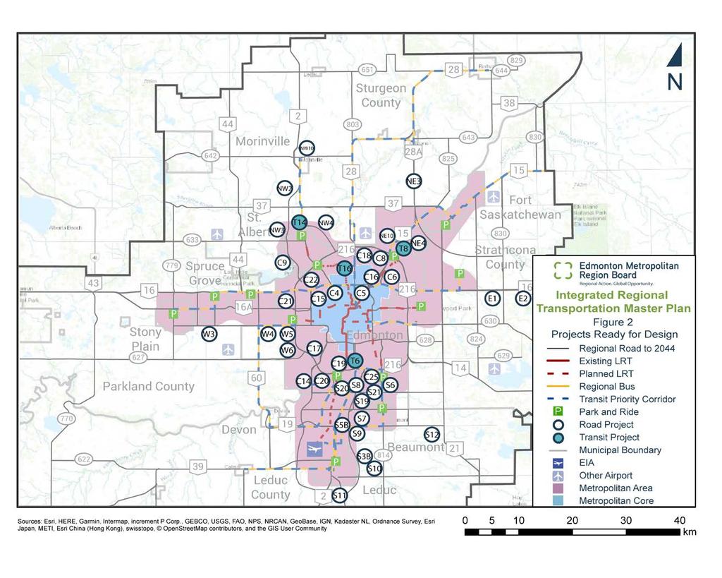
12 Page 12
13 Table 3.3: Project Functional Planning or Study Rank Project Name Project Type Score # 1 Regional HOV Transit Priority Study (Hwy 16, Baseline Rd./98 Ave, Wye Rd./ Sherwood Pk Fwy./ QE2 Hwy to Leduc) HOV Lane/ Transit Priority T1 2 Airport Accord Transit Study Transit Service Study T3 3 Yellowhead Trail (97 Street to St Albert Trail) Upgrade to Free Flow C7 4 Acheson Industrial Area Transit plus Park & Ride 5 Twp Rd 534/Aurum Rd (Anthony Henday Dr. to Highway 21) New Service & Park n Ride Study Realignment of Road + New Interchange on Hwy T E7 6 Airport LRT (Heritage Valley to EIA) LRT Extension T15 7 Strathcona County High-Speed Transit (LRT) LRT Extension Study 99.9 T Street Extension (Highway 19 to Highway 39) New Link 89.4 S St Corridor Study (Terwillegar to QE2 south of Leduc) 10 Highway 16 (Sherwood Drive to Highway 824) 11 St. Albert Trail (North City Limit to Boudreau Rd) Corridor Study 89.4 S22 Widen to 6 lanes and build interchanges Widening/Intersection Upgrades 84.2 E NW6 12 Highway 15/37/825 Intersection - Interchange Interchange 82.0 NE1A 13 Highway 16 (Anthony Henday Dr. to Highway 779) Widening 80.5 W8 14 Highway 21 (Highway 16 to Ft Sask) 15 Highway 15 (East of Fort Saskatchewan to Lamont) including Intersection Improvements at Highways 830, 45 and 29 Upgrade to Freeway; build interchanges Twinning and Intersection Upgrades 76.2 E NE7 16 Highway 21 (Highway 14 to Highway 628) Twinning 74.1 E3 16 Highway 16 at Highways 43 & 770 Interchange 74.1 W Street (167 Avenue to Anthony Henday Dr.) Widening 70.5 C23 19 Spruce Grove Regional Park n Ride New Park n Ride 69.7 T13 20 Highway 21 (Highway 625 to Highway 14 ) Twinning 64.6 E St Albert Trail Intelligent Transportation Systems (North City Limit to AHD) 170 Street (41 Avenue SW to Highway 19) Extension ITS 61.7 NW9 New Link 61.1 S14 23 Hwy 2A extension (QE2 to 170 St /Highway 39) New Link 45.8 S15 24 Highway 830 (Highway 16 to Highway 15) Twinning 40.0 E10 Page 13
14 Rank Project Name Project Type Score # Nisku Spine Road (Highway 623 to Highway 2A/QE2) North St. Albert Regional Park n Ride at the north end of St. Albert Trail New Link 40.0 S18 New Park n Ride 34.8 T12 27 Highway 28 (195 Avenue to Highway 28A) Twinning 28.3 NE8 28 Highway 21 (Highway 628 to Highway 16) Upgrade to Freeway; build interchanges 28.0 E11 29 Highway 627 (199 St to Highway 60) Twinning 19.3 W Street (Anthony Henday Dr. to Edmonton City Limit) New Link 17.4 C Ave/Twp Rd 512 (50 St to Hwy 21) Upgrade existing road 15.7 E12 See Figure 3: Project Functional Planning or Study Map Page 14

15 2018 Regional Transportation Priorities Page 15
16 4.0 COMPLETED PROJECTS 4.1 Funded and/or Completed Projects The 2018 Transportation Priorities Report represents the fifth year that priorities have been established. It is important to recognize and celebrate the success of the collaborative effort in attaining funding and completing projects. It has been demonstrated that the Priority Lists are being used by the members and the Province in planning and building future regional transportation infrastructure. Accordingly, some of the regional successes are listed below: Campbell Regional Park and Ride Commencement of construction of the SE-LRT (City Centre - Mill Woods) Highway 37/825/15 Intersection Improvements to commence Commencement of functional plan for new Northeast River Crossing Twinning of east and west ends Highway 19 commenced Highway 15 bridge twining over North Saskatchewan River commenced Heritage Valley Park and Ride Fort Saskatchewan Park and Ride QEII Highway widening on southbound lanes to Highway CONCLUSION AND RECOMMENDATIONS 5.1 Conclusion The transportation project lists have been updated and successfully prioritized in a manner that reflects both the policy goals of the Edmonton Metropolitan Region Growth Plan, as well as on-theground challenges and imperatives. Implementing any long term strategies such as the IRTMP and the Growth Plan, requires an ongoing commitment to planning, design and construction that is reasonably true to the underlying policy objectives. As such, the process for arriving at regional transportation priorities identified priorities in three categories: construction, design and functional planning. The regional project priorities listed in Tables include a mixture of project types that respond to urgencies throughout the Edmonton Metropolitan Region. More importantly, the priorities were arrived at collaboratively between a mix of municipal and provincial representatives. It is recognized that while completion of planning and design activities are crucial elements of project implementation, other activities such as land acquisition and funding harmonization that may also need to be completed to effect project construction. Nevertheless, the prioritized lists should serve to inform municipal and provincial priorities over the next three years and help the region coordinate and align its infrastructure investments with a better understanding and respect for differing interests. Page 16
17 5.2 Recommendations The following recommendations are made to advance the implementation of regionally important transportation projects: 1. That the recommended regional transportation priorities reflected in Tables be approved by the EMRB. 2. That the EMRB forward the regional priorities expressed in this report to the Government of Alberta for active consideration in the preparation of its 2019 Three Year Capital Plan. 3. That the EMRB continue to support the annual update of the regional transportation priorities to reflect changing and emerging priorities. 4. That the EMRB plan for the review and update of the Integrated Regional Transportation System Study and the, including a comprehensive review and update of the approach and methodology of prioritizing projects, based on the new Edmonton Metropolitan Region Growth Plan. Page 17
18 Appendix A: Master Project List # Project Name Project Type Project Status Central Sector C3 75 Street (Argyll Road to Whitemud Dr) Widening Construction C4 Yellowhead Trail (156 Street to St Albert Trail) Upgrade to Free Flow Design C5 Yellowhead Trail (50 Street to 97 Street) Upgrade to Free Flow Design C6 Yellowhead Trail (Victoria Trail to 50 Street) Widening Design C7 Yellowhead Trail (97 Street to St Albert Trail) Upgrade to Free Flow Functional/Concept Plan C8 Manning Drive (137 Avenue - Anthony Henday Drive) Widening Design C9 Ray Gibbon Drive (Anthony Henday to Villeneuve Road) Twinning Design C Street (Ambleside Dr (s/b AH?) to 41 Avenue SW) Widening Design C Street CN Grade Separation Grade Separation Design C16 Fort Road (Yellowhead Trail to 66 St) Widening/Intersection Upgrades Design C17 Terwillegar Drive (Whitemud Drive to Anthony Henday Dr.) Upgrade to Free Flow Design C18 Anthony Henday Drive (50 St. Northeast Overpass) Interchange Design C19 Anthony Henday Drive (135 St Overpass SW) Interchange Design C20 Anthony Henday Drive (SW River Xing to QE2) Widening Design C21 Anthony Henday Drive (109/111 Ave Overpass) Interchange Design C22 Anthony Henday Drive (Add 137 Ave Ramps) Interchange Design C23 97 Street (167 Avenue to Anthony Henday Dr.) Widening Functional/Concept Plan C Street (Anthony Henday Dr. to Edmonton City Limit) New Link Functional/Concept Plan C25 91 Street (Ellerslie Road to 41 Avenue SW) Widening Design East Sector E1 Highway 16 (Interchange at 830) Interchange Design E2 Highway 16 (Highway 824 to Elk Island Park) Access management Design E3 Highway 21 (Highway 14 to Highway 628) Twinning Functional/Concept Plan E4 Highway 21 (Highway 16 to Ft Sask) Upgrade to Freeway; build interchanges Functional/Concept Plan E5 Highway 16 (Sherwood Drive to Highway 824) Widen to 6 lanes and build interchanges Functional/Concept Plan E6 Highway 628 (Anthony Henday Dr. to Highway 21) Twinning Construction E7 Twp Rd 534/Aurum Rd (Anthony Henday Dr. to Highway Realignment of Road + New Functional/Concept Plan 21) Interchange on Hwy 21 E9 Highway 21 (Highway 625 to Highway 14 ) Twinning Functional/Concept Plan E10 Highway 830 (Highway 16 to Highway 15) Twinning Functional/Concept Plan E11 Highway 21 (Highway 628 to Highway 16) Upgrade to Freeway; build Functional/Concept Plan interchanges E12 41 Ave/Twp Rd 512 (50 St to Hwy 21) Upgrade existing road Functional/Concept Plan Northeast Sector NE1A Highway 15/37/825 Intersection - Interchange Interchange Functional/Concept Plan NE2 Highway 28 (Highway 28A to Highway 63) Twinning Construction NE3 Highway 28A (Highway 15 to Highway 28) Twinning Design NE4 Northeast River Crossing (Hwy 21/Twp Rd 540 to Hwy 28A) New Link Design NE7 Highway 15 (East of Fort Saskatchewan to Lamont) Twinning and Intersection Functional/Concept Plan including Intersection Improvements at Hwys 830, 45 & 29 Upgrades NE8 Highway 28 (195 Avenue to Highway 28A) Twinning Functional/Concept Plan NE9 Highway 643 (Highway 28A to Agrium) Signals & Intersection Construction Upgrades NE10 Highway 15 (Manning Dr.) near Meridian Street Interchange Design Northwest Sector NW1 Highway 2 at Cardiff Rd Interchange Construction NW2 Ray Gibbon Drive (Highway 37 to Highway 2) Extend-first 2 lanes Design NW3 Ray Gibbon Drive (Villeneuve Rd. to Highway 37) Extend-first 2 lanes Design NW4 127 Street (Edmonton City Limit to St. Albert Trail/Hwy 2) New Link Design Page 18
19 # Project Name Project Type Project Status NW6 St. Albert Trail (North City Limit to Boudreau Rd) Widening/Intersection Functional/Concept Plan Upgrades NW9 St Albert Trail Intelligent Transportation Systems ITS Functional/Concept Plan (North City Limit to AHD) NW10 Highway 642 (Highway 2 to East Boundary Road) Intersection Improvements Design South Sector S1 Highway 19 (QE2 Highway to Highway 60) Twinning Construction S3B Nisku Spine Road (Allard Ave to 65 Ave) Upgrade existing road Design S4 QE2/65 Avenue (Leduc) Interchange & Arterial Interchange Construction S5A Nisku Spine Road (Twp Rd 510 to 25 Ave) New Link Construction S5B Nisku Spine Road (25 Ave to Highway 625) Twinning Design S6 50 Street (Ellerslie Road to 41 Avenue SW) Widening Design S7 Highway 625 (Nisku to Range Road 241 Beaumont) Twinning Design S8 QE2 Highway/Ellerslie Rd. Interchange Upgrading Upgrade Existing Design Interchange S9 Nisku Spine Road (Highway 625 to Airport Road) Upgrade existing road Design S10 Nisku Spine Road (65 Ave to Highway 623 (Rollyview rd.)) New Link Design S11 QE2 Highway/Highway 2A Interchange New Interchange Design S12 Highway 625 (Range Road 241 to Highway 21) Twinning Design S Street Extension (Highway 19 to Highway 39) New link Functional/Concept Plan S Street (41 Avenue SW to Highway 19) Extension New Link Functional/Concept Plan S15 Hwy 2A extension (QE2 to 170 St /Highway 39) New Link Functional/Concept Plan S18 Nisku Spine Road (Highway 623 to Highway 2A/QE2) New Link Functional/Concept Plan S19 Twp Rd 510 (QE2 to 50 Street) Upgrade existing road Design S20 41 Ave (127 St to170 St) Upgrade existing road Design S21 41 Ave (91 St to 50 St) Upgrade existing road Design S St Corridor Study (Terwillegar to QE2 south of Leduc) Corridor Study Study West Sector W1 Highway 60 (Highway 16A to Highway 16) Twinning & Rail-Grade Construction Separation W2 Hwy 779 (Highway 16A to Highway 628) Upgrade existing road Construction W3 Highway 628 (Highway 60 to Highway 779) Reconstruct and Surface Design W4 Whitemud Drive/Highway 628 (231 Street to Highway 60) Twinning Design W5 Whitemud Drive/Hwy 628 (Anthony Henday Dr. to 231 St.) Upgrade existing road Design W6 Highway 627 (Anthony Henday Dr. to 199 St) New Link Design W8 Highway 16 (Anthony Henday Dr. to Highway 779) Widening Functional/Concept Plan W9 Highway 627 (199 St to Highway 60) Twinning Functional/Concept Plan W10 Highway 16 at Highways 43 & 770 Interchange Functional/Concept Plan Transit T1 Regional HOV Transit Priority Study (Hwy 16, Baseline HOV Lane/ Transit Priority Study Rd./98 Ave, Wye Rd./ Shwd Pk Fwy./ QE2 Hwy to Leduc) T2 Strathcona County High-Speed Transit (LRT) LRT Extension Study Study T3 Airport Accord Transit Study Transit Service Study Study T4 Acheson Industrial Area Transit plus Park & Ride New Service & Park n Ride Study Study T5 West LRT (Downtown to Lewis Estates) LRT Extension Construction T6 South LRT (Century Park to Ellerslie) LRT Extension Design T7 NW LRT (NAIT to Blatchford) LRT Extension Construction T8 NE LRT (Clareview to Gorman) LRT Extension Design T12 St. Albert Regional Park n Ride at the north end of St. New Park n Ride Functional/Concept Plan Albert Trail T13 Spruce Grove Regional Park n Ride New Park n Ride Functional/Concept Plan T14 NW LRT (Campbell Rd TC to North St. Albert Park n Ride) LRT Extension Design T15 Airport LRT (Heritage Valley to EIA) LRT Extension Functional/Concept Plan T16 NW LRT (Blatchford to Campbell Rd Transit Centre) LRT Extension Design Page 19
20 Appendix B: Regional Roadway and Transit Priority Lists Table B.1: Projects Ready for Construction - Roadway Rank Project Name Project Type Score # 1 QE2/65 Avenue (Leduc) Interchange & Arterial Interchange S4 2 Highway 19 (QE2 Highway to Highway 60) Twinning S1 3 Highway 60 (Highway 16A to Highway 16) Twinning & Rail-Grade Separation W Street (Argyll Road to Whitemud Dr) Widening C3 5 Nisku Spine Road (Twp Rd 510 to 25 Ave) New Link S5A 6 Highway 643 (Highway 28A to Agrium) Signals & Intersection Upgrades 76.3 NE9 7 Highway 28 (Highway 28A to Highway 63) Twinning 70.8 NE2 8 Highway 628 (Anthony Henday Dr. to Highway 21) Twinning 53.3 E6 9 Highway 2 at Cardiff Rd Interchange 35.9 NW1 10 Hwy 779 (Highway 16A to Highway 628) Upgrade existing road 26.1 W2 Table B.2: Projects Ready for Construction - Transit Rank Project Name Project Type Score # 1 West LRT (Downtown to Lewis Estates) LRT Extension T5 2 NW LRT (NAIT to Blatchford) LRT Extension T7 Page 20
21 Table B.3: Projects Ready for Design - Roadway Rank Project Name Project Type Score # 1 Yellowhead Trail (50 Street to 97 Street) Upgrade to Free Flow C5 1 Yellowhead Trail (156 Street to St Albert Trail) Upgrade to Free Flow C4 3 Fort Road (Yellowhead Trail to 66 St) Widening/Intersection Upgrades C16 4 Highway 28A (Highway 15 to Highway 28) Twinning NE3 5 Highway 625 (Nisku to Range Road 241 Beaumont) Twinning S7 6 Ray Gibbon Drive (Anthony Henday to Villeneuve Road) Twinning C9 7 Yellowhead Trail (Victoria Trail to 50 Street) Widening C6 8 Highway 16 (Interchange at 830) Interchange 90.5 E Street (Ellerslie Road to 41 Avenue SW) Widening 80.6 S6 10 QE2 Highway/Ellerslie Rd. Interchange Upgrading Upgrade Existing Interchange 80.5 S8 11 Terwillegar Drive (Whitemud Drive to Anthony Henday Drive) Upgrade to Free Flow 79.5 C17 12 Anthony Henday Drive (SW River Xing to QE2) Widening 78.4 C20 13 Highway 15 (Manning Dr.) near Meridian Street Interchange 74.8 NE10 14 Nisku Spine Road (Highway 625 to Airport Road) Upgrade existing road 70.3 S9 14 Nisku Spine Road (25 Ave to Highway 625) Twinning 70.3 S5B Street (Ambleside Dr (s/b AH) to 41 Avenue SW) Widening 63.9 C14 17 Highway 16 (Highway 824 to Elk Island Park) Access management 63.8 E2 18 Nisku Spine Road (Allard Ave to 65 Ave) Upgrade existing road 60.9 S3B Street CN Grade Separation Grade Separation 51.5 C Ave (91 St to 50 St) Upgrade existing road 50.2 S21 20 Highway 625 (Range Road 241 to Highway 21) Twinning 50.2 S Nisku Spine Road (65 Ave to Highway 623 (Rollyview rd.)) New Northeast River Crossing (Highway 21/Twp Rd 540 to Highway 28A) 127 Street (Edmonton City Limit to St. Albert Trail/Highway 2) New Link 49.4 S10 New Link 48.8 NE4 New Link 48.7 NW4 25 Highway 628 (Highway 60 to Highway 779) Reconstruct and Surface 48.0 W3 26 Highway 627 (Anthony Henday Dr. to 199 St) New Link 45.8 W6 27 Highway 642 (Highway 2 to East Boundary Road) Intersection Improvements 42.8 NW10 Page 21
22 Rank Project Name Project Type Score # 28 Twp Rd 510 (QE2 to 50 Street) Upgrade existing road 40.8 S19 29 Anthony Henday Drive (50 St. Northeast Overpass) Interchange 36.3 C Street (Ellerslie Road to 41 Avenue SW) Widening 35.2 C Whitemud Drive / Highway 628 (231 Street to Highway 60) Whitemud Drive / Highway 628 (Anthony Henday Dr. to 231 Street) Twinning 34.8 W4 Upgrade existing road 34.8 W Ave (127 St to170 St) Upgrade existing road 31.3 S20 34 Manning Drive (137 Avenue - Anthony Henday Drive) Widening 31.2 C8 35 QE2 Highway/Highway 2A Interchange New Interchange 28.0 S11 36 Anthony Henday Drive (Add 137 Ave Ramps) Interchange 26.8 C22 36 Anthony Henday Drive (135 St Overpass SW) Interchange 26.8 C19 38 Ray Gibbon Drive (Villeneuve Rd. to Highway 37) Extend-first 2 lanes 24.4 NW3 39 Anthony Henday Drive (109/111 Ave Overpass) Interchange 22.1 C21 40 Ray Gibbon Drive (Highway 37 to Highway 2) Extend-first 2 lanes 15.3 NW2 Table B.4: Projects Ready for Design - Transit Rank Project Name Project Type Score # 1 NW LRT (Blatchford to Campbell Rd Transit Centre) LRT Extension T16 2 South LRT (Century Park to Ellerslie) LRT Extension 94.4 T6 3 NE LRT (Clareview to Gorman) LRT Extension 90.4 T8 4 NW LRT (Campbell Rd TC to North St. Albert Park n Ride) LRT Extension 45.2 T14 Page 22
23 Table B.5: Project Functional Planning or Study - Roadway Rank Project Name Project Type Score # 1 Yellowhead Trail (97 Street to St Albert Trail) Upgrade to Free Flow C7 2 Twp Rd 534/Aurum Rd (Anthony Henday Dr. to Highway 21) Realignment of Road + New Interchange on Hwy E Street Extension (Highway 19 to Highway 39) New Link 89.4 S St Corridor Study (Terwillegar to QE2 south of Leduc) 5 Highway 16 (Sherwood Drive to Highway 824) 6 St. Albert Trail (North City Limit to Boudreau Rd) Corridor Study 89.4 S22 Widen to 6 lanes and build interchanges Widening/Intersection Upgrades 84.2 E NW6 7 Highway 15/37/825 Intersection - Interchange Interchange 82.0 NE1A 8 Highway 16 (Anthony Henday Dr. to Highway 779) Widening 80.5 W8 9 Highway 21 (Highway 16 to Ft Sask) 10 Highway 15 (East of Fort Saskatchewan to Lamont) including Intersection Improvements at Highways 830, 45 and 29 Upgrade to Freeway; build interchanges Twinning and Intersection Upgrades 76.2 E NE7 11 Highway 21 (Highway 14 to Highway 628) Twinning 74.1 E3 11 Highway 16 at Highways 43 & 770 Interchange 74.1 W Street (167 Avenue to Anthony Henday Dr.) Widening 70.5 C23 14 Highway 21 (Highway 625 to Highway 14 ) Twinning 64.6 E St Albert Trail Intelligent Transportation Systems (North City Limit to AHD) 170 Street (41 Avenue SW to Highway 19) Extension ITS 61.7 NW9 New Link 61.1 S14 17 Hwy 2A extension (QE2 to 170 St /Highway 39) New Link 45.8 S15 18 Highway 830 (Highway 16 to Highway 15) Twinning 40.0 E10 18 Nisku Spine Road (Highway 623 to Highway 2A/QE2) New Link 40.0 S18 20 Highway 28 (195 Avenue to Highway 28A) Twinning 28.3 NE8 21 Highway 21 (Highway 628 to Highway 16) Upgrade to Freeway; build interchanges 28.0 E11 22 Highway 627 (199 St to Highway 60) Twinning 19.3 W Street (Anthony Henday Dr. to Edmonton City Limit) New Link 17.4 C Ave/Twp Rd 512 (50 St to Hwy 21) Upgrade existing road 15.7 E12 Page 23
24 Table B.6: Project Functional Planning or Study - Transit Rank Project Name Project Type Score # 1 Regional HOV Transit Priority Study (Hwy 16, Baseline Rd./98 Ave, Wye Rd./ Sherwood Pk Fwy./ QE2 Hwy to Leduc) HOV Lane/ Transit Priority T1 2 Airport Accord Transit Study Transit Service Study T3 3 Acheson Industrial Area Transit plus Park & Ride New Service & Park n Ride Study T4 4 Airport LRT (Heritage Valley to EIA) LRT Extension T15 5 Strathcona County High-Speed Transit (LRT) LRT Extension Study 99.9 T2 6 Spruce Grove Regional Park n Ride New Park n Ride 69.7 T13 7 North St. Albert Regional Park n Ride at the north end of St. Albert Trail New Park n Ride 34.8 T12 Page 24
Land Use & Planning Committee. Agenda
 1. Call to Order Mayor Tom Flynn, Chair 2. Chair Opening Remarks Agenda Thursday, April 28, 2016 9:00 a.m. 11:00 a.m. La Cite Francophone Hall Jean-Louis Dentinger 8627 rue-marie-gaboury (91 Street), Edmonton
Land Use & Planning Committee. Agenda
 Agenda Thursday, April 27, 2017 9:00 a.m. 11:30 a.m. La Cite Francophone Hall Jean-Louis Dentinger 8627 rue-marie-gaboury (91 Street), Edmonton Agenda Items 1. Call to Order 2. Chair Opening Remarks 3.
CITY COUNCIL AGENDA REPORT
 CITY COUNCIL AGENDA REPORT Subject: COUNCIL MOTION LRT ALIGNMENT REMOVAL FROM THE TRANSPORTATION MASTER PLAN On February 10, 2016 Councillor Hughes provided notice in accordance with Section 23 of Procedure
Northeast Anthony Henday Drive Manning Freeway to Whitemud Drive Welcome to this Construction Information Session
 Manning Freeway to Whitemud Drive Welcome to this Construction Information Session Purpose To inform interested residents and businesses about the plans accommodation. Background: The Government of Alberta
NORTHEAST RIVER CROSSING FUNCTIONAL PLANNING STUDY
 WELCOME Northeast River Crossing Functional Planning Study Phase 2 Public Meeting 4 to 8 PM Informal drop-in format and discussion tables Meeting Purpose Introduce the Northeast River Crossing Functional
Northwest LRT Downtown to. Northwest Edmonton Study. Public Workshops
 Northwest LRT Downtown to Northwest Edmonton Study Public Workshops March 23 & 24, 2010 Welcome Thank you all for attending Welcome Introductions Welcome Our Team s Commitment to You for Tonight To provide
What We Heard Public Engagement - Stage 1
 What We Heard Public Engagement - Stage 1 Background Early planning is underway for a potential new river crossing over the North Saskatchewan River, in the northeast part of the Edmonton region. The City
CAPITAL LINE SOUTH LRT EXTENSION INTRODUCTION
 INTRODUCTION What: The 2010 preliminary design for the Capital Line South LRT Extension will run from the Century Park Station to Ellerslie Road. It will connect to the Heritage Valley Park and Ride located
Corridor Vision. 1Pursue Minnehaha-Hiawatha Community Works Project. Mission of Hennepin County Community Works Program
 1Pursue Minnehaha-Hiawatha Community Works Project Minnehaha-Hiawatha Community Works is a project within the Hennepin Community Works (HCW) program. The mission of the HCW program is to enhance how the
edmonton.ca/ribbonofgreen #ribbonofgreen
 WHAT IS THE RIBBON OF GREEN? The Ribbon of Green is Edmonton s entire river valley and ravine system. The Ribbon of Green (2018) Project will provide strategic guidance for the southwest and northeast
ln the North Saskatchewan River Valley and Ravine System
 ln the North Saskatchewan River Valley and Ravine System December 2000 Environmental Planning Corporate Planning and Policy Section Planning and Policy Services Branch RIVER VALLEY ENVIRONMENTAL REVIEW
1 INTRODUCTION Purpose Project Background PROJECT CONTEXT Background The Capital City Downtown Plan...
 Attachment 3 Contents CONTENTS 1 INTRODUCTION... 3 Purpose... 3 Project Background... 3 2 PROJECT CONTEXT... 9 Background... 9 The Capital City Downtown Plan... 9 The LRT Expansion Plan - LRT Downtown
A General Summary of Land Use Zones 1
 A General Summary of Land Use s 1 2 A General Summary of Land Use s A General Summary of Land Use s Land use zones are used to classify and regulate land development and use. The following descriptions
WELCOME 50 street cp rail grade separation + road widening. public information session #1 June 26, pm to 8 pm
 WELCOME 50 street cp rail grade separation + road widening public information session #1 June 26, 2018 5 pm to 8 pm session purpose To provide residents, businesses, and users of 50 Street with the opportunity
Local Growth Planning in North Central Green Line Communities
 2018 April 30 Page 1 of 6 EXECUTIVE SUMMARY This report outlines a high-level scope for local growth planning for north central Green Line communities. The catalyst for this review is the significant investments
Summary of Changes for the Comprehensive Draft Proposed Official Plan Amendment
 Summary of Changes for the Comprehensive Draft Proposed Official Plan Amendment Note: Due to the broad scope of the Official Plan Review, this list is not exhaustive of the extent of changes in the comprehensive
WELCOME TO OPEN HOUSE TWO November 28, 2018
 Langstaff Road Weston Road to Highway 7 Class Environmental Assessment Study WELCOME TO OPEN HOUSE TWO November 28, 2018 Please sign in and join our mailing list Study Overview York Region is conducting
Edmonton s LRT Setting the Stage for Heading Further South
 4 Capital Projects Project Updates Edmonton s LRT Setting the Stage for Heading Further South Art Washuta, P.Eng. AECOM Canada Ltd. Edmonton, Alberta Carole Cej, P.Eng. City of Edmonton Edmonton, Alberta
1.0 INTRODUCTION & BACKGROUND
 1.0 INTRODUCTION & BACKGROUND 1.1 GENERAL The Consulting Team was retained by the City of Edmonton in 2010 to complete a for the replacement of the Walterdale Bridge and the approach roads, as required,
Aurum Industrial Business Park Area Structure Plan
 Aurum Industrial Business Park Area Structure Plan Office Consolidation September 2017 Prepared by: Planning and Policy Services Branch Planning and Development Department City of Edmonton Bylaw 9809 was
9 CITY OF VAUGHAN OFFICIAL PLAN AMENDMENT NO BOCA EAST INVESTMENTS LIMITED
 9 CITY OF VAUGHAN OFFICIAL PLAN AMENDMENT NO. 631 - BOCA EAST INVESTMENTS LIMITED The Planning and Economic Development Committee recommends the adoption of the recommendations contained in the following
TOWN OF WHITBY REPORT RECOMMENDATION REPORT
 TOWN OF WHITBY REPORT RECOMMENDATION REPORT REPORT TO: Council REPORT NO: PL 95-09 DATE OF MEETING: October 13, 2009 PREPARED BY: Planning/Public Works Joint Report FILE NO(S): N/A LOCATION: N/A REPORT
2017 Canadian Consulting Engineering Awards
 2017 Canadian Consulting Engineering Awards Northeast Anthony Henday Drive DBFO Edmonton, Alberta Four years of detours, traffic snarls, varying speed limits, and stop-and-start driving has come to an
Yellowhead Corridor Area Structure Plan
 Yellowhead Corridor Area Structure Plan Office Consolidation June 2014 Prepared by: Current Planning Branch Sustainable Development City of Edmonton Bylaw 7044, as amended, was adopted by Council in April
Hurontario/Main Street Corridor Master Plan Mississauga and Brampton Building a new and integrated vision for the corridor
 Hurontario/Main Street Corridor Master Plan Mississauga and Brampton Building a new and integrated vision for the corridor Martin Powell, Commissioner of Transportation and Works, City of Mississauga Paper
NORTH-SOUTH CORRIDOR STUDY EXECUTIVE SUMMARY. Executive Summary
 Executive Summary Background As congestion continues to affect mobility in the region, the Ozarks Transportation Organization (OTO) is particularly concerned with traffic movement. The North-South Corridor
Issues Requiring Future Study
 Issues Requiring Future Study Transportation planning is an ongoing process that tends to identify new issues as it finds solutions for others. Some issues are so complex that a solution to one problem
Welcome. Green Line LRT. Beltline Alignment Options. Stay engaged! Follow the Green Line story at calgary.ca/greenline
 Welcome Green Line LRT Beltline Alignment Options Stay engaged! Follow the Green Line story at calgary.ca/greenline Green Line LRT Why are we here? Our Challenge Determine the best alignment in the Beltline.
Northwest Rail Corridor and US 36 BRT Development Oriented Transit Analysis 4.4 STATION AREA FINDINGS
 4.4 STATION AREA FINDINGS Each station is different, and each one requires a separate set of recommendations based on the vision for the site. This section outlines an initial TOD strategy and recommendations
Complete Streets Guidelines & Implementation Strategy. Public Open House #2 June 12, :30-8:00 pm
 Complete Streets Guidelines & Implementation Strategy Public Open House #2 June 12, 2018 5:30-8:00 pm Purpose The purpose of this project is to develop Complete Streets guidelines and an implementation
TRANSPORTATION ELEMENT GOALS, OBJECTIVES, AND POLICIES
 TRANSPORTATION ELEMENT GOALS, OBJECTIVES, AND POLICIES GOAL 2 The City shall provide a safe, convenient, effective, and energy efficient multimodal transportation system which is coordinated with the Future
CHAPTER 7: Transportation, Mobility and Circulation
 AGLE AREA COMMUNITY Plan CHAPTER 7 CHAPTER 7: Transportation, Mobility and Circulation Transportation, Mobility and Circulation The purpose of the Transportation, Mobility and Circulation Chapter is to
The West Vaughan Employment Area Secondary Plan Policies
 Part 2: The West Vaughan Employment Area Secondary Plan Policies 2.1 General Policies It is the policy of Council: 2.1.1. That the West Vaughan Employment Area (the WVEA), identified on Schedule 1, will
Introduction. Public Information Package. Project website. Overview. Class Environmental Assessment Process
 1 Introduction Public Information Package Baseline Road Extension between Lambs Road and Bennett Road, Bowmanville Schedule B Municipal Class Environmental Assessment November 6, 2017 Overview The purpose
Mill Woods Town Centre Proposed Rezoning LDA
 Mill Woods Town Centre Proposed Rezoning LDA15 0649 The City of Edmonton has received an application for rezoning and an amendment to the Mill Woods Station Area Redevelopment Plan (ARP) for the Mill Woods
Mistatim Area Structure Plan
 Mistatim Area Structure Plan Office Consolidation September 2013 Prepared by: Current Planning Branch Sustainable Development City of Edmonton Amended by Editor Bylaw 7205 adopted by Council in July 1983.
Right-of-Way Acquisitions and Relocations Technical Memorandum
 Right-of-Way Acquisitions and Relocations Technical Memorandum Southeast Extension Project Lincoln Station to RidgeGate Parkway Prepared for: Federal Transit Administration Prepared by: Denver Regional
Public Information Centre #1
 and Highway 401 Interchange Improvements WELCOME Public Information Centre #1 Veterans Memorial Parkway Extension and Highway 401 Interchange Improvements Study May 23, 2012 4 p.m. to 7 p.m. Brief Overview
Section 28, Township 52, Range 26, West of the 4th Meridian
 Section 28, Township 52, Range 26, West of the 4th Meridian Outline Plan Including the Highlands Business Park Study Area Parkland County February 2017 Prepared by: Highlands Business Park LP Stantec Consulting
Berkeley Strategic Transportation Plan
 Berkeley Strategic Transportation Plan 48 4. Priming the Pipeline 4. Priming the Project Pipeline Building on our history Using past studies that required the effort and input of all of Berkeley s distinct
East Corridor Final Environmental Impact Statement
 East Corridor Final Environmental Impact Statement Alternatives Considered Operating Plan The requirements for opening day operations versus year 2030 are based on ridership and operations. Opening day
Description of Preferred Alternative
 Chapter 2 Description of Preferred Alternative 2.1 Introduction This chapter of the programmatic Sammamish Town Center Sub-area Plan Final EIS provides a more detailed description of the Preferred Alternative
DRAFT Subject to Modifications
 TREASURE COAST REGIONAL PLANNING COUNCIL M E M O R A N D U M To: Council Members AGENDA ITEM 8 From: Date: Subject: Staff May 19, 2017 Council Meeting Florida Department of Transportation Complete Streets
Mavis Road Class Environmental Assessment
 Mavis Road Class Environmental Assessment Public Information Centre #2 Wednesday November 9, 2016 6:00 to 8:00 p.m. Please sign in and complete a comment sheet Review the displays on your own or join in
112th Avenue Light Rail Options Concept Design Report JUNE 2010 PREPARED FOR PREPARED BY TBG PGH
 112th Avenue Light Rail Options Concept Design Report JUNE 2010 PREPARED FOR PREPARED BY TBG060310124909PGH C ontents Introduction 1 Project Overview 1 Public Involvement and Technical Coordination 4 Description
CITY OF VAUGHAN EXTRACT FROM COUNCIL MEETING MINUTES OF JUNE 7, 2016
 Item 5, Report No. 26, of the Committee of the Whole (Working Session), which was adopted without amendment by the Council of the City of Vaughan on June 7, 2016. 5 MUNICIPAL CLASS ENVIRONMENTAL ASSESSMENT
Leduc Industrial Outline Plan SE W4
 Leduc Industrial Outline Plan SE 1-50-25-W4 Within the North Leduc Industrial ASP Prepared for: Leduc Energy Park Ltd. Prepared by: Stantec Consulting Ltd. File No. 1161 104655 V5 Table of Contents 1.0
Upcoming Projects and Emerging Issues
 Upcoming Projects and Emerging Issues Strathcona County Working Together With The Consulting Engineers of Alberta http://www.strathcona.ca CEA Partnering with Industry Symposium January 18, 2018 Presentation
NEW REGIONAL OFFICIAL PLAN HIGH LEVEL PROCESS & FRAMEWORK
 NEW REGIONAL OFFICIAL PLAN HIGH LEVEL PROCESS & FRAMEWORK Why A New Official Plan Originally the role of Regionally Planning and content of Regional Official Plan (1970s) primarily focused on protecting
Eglinton West LRT Update
 Eglinton West LRT Update Community Consultation Update May 16, 2016 Background Rapid transit along Eglinton Ave between Kennedy Station and Pearson Airport was included in the Metrolinx Regional Transportation
South Fulton Parkway Transit Feasibility Study
 South Fulton Parkway Transit Feasibility Study Study Purpose To conduct a high level assessment of potential transit improvements in the South Fulton Parkway Corridor through the evaluation of various
PUBLIC OPEN HOUSE HURONTARIO-MAIN CORRIDOR SECONDARY PLAN
 PUBLIC OPEN HOUSE HURONTARIO-MAIN CORRIDOR SECONDARY PLAN Tuesday, February 28, 2012 6pm 9pm 1 st Floor Atrium, City Hall 2 Wellington Street West, Brampton 1 POLICY FRAMEWORK The 2006 Provincial Growth
Services Department B September 10, 2007
 Report To: Development Services Committee Item: Date of Report: DS-07-246 September 5, 2007 From: Commissioner, Development File: Date of Meeting: Services Department B7200-0001 September 10, 2007 Subject:
TOWN OF BRUDERHEIM Report to the capital region board
 TOWN OF BRUDERHEIM Report to the capital region board Introduction to the Town of Bruderheim Municipal Development Plan amendment and Relation to the CRB Evaluation Criteria 02 march 2017 1 Introduction
Shift Rapid Transit Public Participation Meeting May 3, 2017
 Shift Rapid Transit Public Participation Meeting May 3, 2017 Shift Rapid Transit Initiative Largest infrastructure project in the city s history. Rapid Transit initiative will transform London s public
TREASURE COAST REGIONAL PLANNING COUNCIL M E M O R A N D U M. To: Council Members AGENDA ITEM 5H
 TREASURE COAST REGIONAL PLANNING COUNCIL M E M O R A N D U M To: Council Members AGENDA ITEM 5H From: Date: Subject: Staff October 17, 2008 Council Meeting Local Government Comprehensive Plan Review Draft
Gorman Neighbourhood Structure Plan LDA WELCOME RESIDENTS. edmonton.ca/gormanneighbourhoodplan. CITY OF EDMONTON Sustainable Development
 Gorman Neighbourhood Structure lan WELCOME RESIDENTS Gorman Neighbourhood Structure lan AGENDA & CONTACT INFO Tonight s Agenda City of Edmonton File lanner Information Sarah Ramey, File lanner Registration
Parks Master Plan Implementation: Phase I Waterfront Use and Design REPORT #: September 7, 2016 File #
 0 'O DI Lan-171-14 1 - THE CORPORATION OF THE TOWN OF COBOURG..,. STAFF REPORT TO: FROM: Mayor and Members of Council Dean A. Hustwick, Director of Recreation and Culture DATE OF MEETING: Committee of
12 AMENDMENT NO. 149, TOWN OF MARKHAM HIGHWAY 404 NORTH SECONDARY PLAN
 12 AMENDMENT NO. 149, TOWN OF MARKHAM HIGHWAY 404 NORTH SECONDARY PLAN The Planning and Economic Development Committee recommends the adoption of the recommendation contained in the following report August
APPENDIX C: Unfunded Projects
 1 Recreation, Parks Culture & Attractions 2 Various Baseball Diamond Enhancements - Planning, Design & Deliver Planning and design and construction of various ball diamond enhancements including shale
MODEL ACCESS MANAGEMENT PLAN MINNESOTA TRUNK HIGHWAY 7 COMPREHENSIVE PLAN AMENDMENT (HUTCHINSON SEGMENT)
") MODEL ACCESS MANAGEMENT PLAN MINNESOTA TRUNK HIGHWAY 7 (HUTCHINSON SEGMENT) COMPREHENSIVE PLAN AMENDMENT INTRODUCTION. The purpose of this plan is to provide consistent access management in the Trunk
MODEL ACCESS MANAGEMENT PLAN MINNESOTA TRUNK HIGHWAY 7 (HUTCHINSON SEGMENT) COMPREHENSIVE PLAN AMENDMENT INTRODUCTION. The purpose of this plan is to provide consistent access management in the Trunk
Welcome. Northern Segment of Hwy 100 I-90 to South of Madison Street Meeting Goals:
 Welcome Northern Segment of Hwy 100 I-90 to South of Madison Street Meeting Goals: - Review Environmental Assessment - Share Preferred Alternative -Receive Public Comments 2003 EA Preferred Alternative
Municipal Development Plan 2013
 UNIQUELY STONY PLAIN: Municipal Development Plan 2013 Quick Reference Guide What is a Municipal Development Plan (MDP)? The Town s highest-level planning document Sets the long-term vision and key themes
6 Growth Management Challenges and Opportunities
 6 Growth Management Challenges and Opportunities The Town has established a goal of attaining a 50% participation rate with respect to employment opportunities versus residential population. The Town s
3 MARKHAM NORTH-SOUTH LINK CORRIDOR PUBLIC TRANSIT IMPROVEMENTS ENVIRONMENTAL ASSESSMENT UPDATE
 3 MARKHAM NORTH-SOUTH LINK CORRIDOR PUBLIC TRANSIT IMPROVEMENTS ENVIRONMENTAL ASSESSMENT UPDATE The Rapid Transit Public/Private Partnership Steering Committee recommends the adoption of the recommendations
Report to: Development Services Committee Report Date: September 11, 2017
 ~RKHAM Report to: Development Services Committee Report Date: September 11, 2017 SUBJECT: PREPARED BY: Conceptual Master Plan for the Future Urban Area - Community Structure Plan and Key Policy Direction
1.0 Introduction. Purpose and Basis for Updating the TMP. Introduction 1
 1.0 Introduction The Town of Castle Rock is situated between the metropolitan areas of Denver and Colorado Springs, amidst a unique terrain of rolling hills, mesas, ravines, and waterways. Like many Front
This page has been intentionally left blank.
 This page has been intentionally left blank. Chapter 3 3-2 3. Employment 3.A Niagara Economic Gateway 3.A.1 General The Niagara Economic Gateway comprises: a) The Gateway Economic Zone which includes all
Henderson County Project Prioritization Discussion
 French Broad River MPO Henderson County Project Prioritization Discussion A discussion on projects considered for MPO Local Input Points in the tier for P 5.0 French Broad River MPO 8-8-2018 INTRODUCTION
Implementation Guide Comprehensive Plan City of Allen
 Implementation Guide 2030 Comprehensive Plan City of Allen DRAFT 2015 Implementation Guide Allen 2030 Comprehensive Plan INTRODUCTION The Comprehensive Plan serves as a guide for the growth and development
WHAT IS THE PURPOSE OF THE OPEN HOUSE?
 WHAT IS THE PURPOSE OF THE OPEN HOUSE? OPEN HOUSE PURPOSE The purpose of the open house is to provide an update on the study process and introduce the preliminary concept alternatives. The open house provides
BYLAW NO. 3549/2015. Being a Bylaw of The City of Red Deer to provide a uniform levy of off-site costs in respect of previously undeveloped land.
 BYLAW NO. 3549/2015 Being a Bylaw of The City of Red Deer to provide a uniform levy of off-site costs in respect of previously undeveloped land. 1 WHEREAS pursuant to provisions of Section 648 of the Municipal
WEST HILL BUSINESS PARK AREA STRUCTURE PLAN
 MUNICIPAL DISTRICT OF PEACE NO. 135 WEST HILL BUSINESS PARK AREA STRUCTURE PLAN Prepared by: TABLE OF CONTENTS 1.0 Introduction... 1 1.1 Purpose of Plan........ 1 1.2 Plan Area..... 1 1.3 Existing Conditions...
Employment and Commercial Review Analysis of Policy Directions
 Employment and Commercial Review Analysis of Policy Directions Appendix A The following analysis is town staff s response to the policy directions provided by the consultants who prepared the Employment
Urban Design Manual PLANNING AROUND RAPID TRANSIT STATIONS (PARTS) Introduction. Station Study Areas
 Introduction. Station Study Areas") 111111 PLANNING AROUND RAPID TRANSIT STATIONS (PARTS) Introduction The ION rapid transit system will link Waterloo, Kitchener and Cambridge through a central transit corridor (CTC). There are a number
111111 PLANNING AROUND RAPID TRANSIT STATIONS (PARTS) Introduction The ION rapid transit system will link Waterloo, Kitchener and Cambridge through a central transit corridor (CTC). There are a number
APPENDIX C: Unfunded Projects
 1 Recreation, Parks Culture & Attractions 2 Various Baseball Diamond Enhancements - Planning, Design & Deliver Planning and design and construction of various ball diamond enhancements including shale
SUMMARY. An Attractive, Competitive and Sustainable GREATER MONTREAL. Draft Metropolitan Land Use and Development Plan. April 2011
 April 2011 Draft Metropolitan Land Use and Development Plan GREATER MONTREAL An Attractive, Competitive and Sustainable SUMMARY Message from the Chair I am pleased to introduce this draft of the Metropolitan
Official Plan Review
 Official Plan Review Summary Report - The Built Environment August 2014 Part 1: Introduction Planning for a healthy, prosperous and sustainable community is an important goal for our municipality. From
Congestion Management Safety Plan. Michael Corbett State Program Administrator September 2017
 Congestion Management Safety Plan Michael Corbett State Program Administrator September 2017 Agenda Topic 1 What is the Congestion Management Safety Plan (CMSP)? 2 Relevance to Congestion Investments 3
Transportation Projects Quarterly Report. Morrisville Planning Department May 22, 2018
 Transportation Projects Quarterly Report Morrisville Planning Department May 22, 2018 Transportation Improvements Most Common Ways the Town secures transportation improvements: 1. Development 2. Grant
Animating the Rideau Canal December 2013
 Executive Summary Animating the Rideau Canal December 2013 Why study the Rideau Canal? The Rideau Canal has been an important part of Ottawa throughout its history, and has shaped and been shaped by the
5.0 IMPLEMENTATION STRATEGIES
 5.0 IMPLEMENTATION STRATEGIES 5.1 Recommended Alternative This chapter discusses the anticipated steps needed to move each project from recommendation to construction. Since full funding for these alternatives
Comprehensive Development Guide
 INDUSTRIAL ELEMENT Comprehensive Development Guide 1 Industrial Element 7.1 Hardin County Industrial Overview BG PKWY Fort Knox Industrial Corridor Comprised of 11 parcels totaling 720 acres of land 68
PLAN ADOPTION AND PLAN AMENDMENT APPLICATION KINGLET GARDENS NEIGHBOURHOOD STRUCTURE PLAN BIG LAKE AREA STRUCTURE PLAN
 Attachment 2 File: LDA13-0086 Kinglet Gardens September 19, 2016 PLAN ADOPTION AND PLAN AMENDMENT APPLICATION KINGLET GARDENS NEIGHBOURHOOD STRUCTURE PLAN BIG LAKE AREA STRUCTURE PLAN This application
TENNESSEE STATE ROUTE 109 CORRIDOR MANAGEMENT AGREEMENT MEMORANDUM OF UNDERSTANDING CORRIDOR MANAGEMENT ALONG STATE ROUTE 109
 TENNESSEE STATE ROUTE 109 CORRIDOR MANAGEMENT AGREEMENT MEMORANDUM OF UNDERSTANDING CORRIDOR MANAGEMENT ALONG STATE ROUTE 109 I. Purpose The purpose of this Agreement is to provide a framework for the
Finch Avenue West and Sheppard Avenue East Corridors - Planning Study Approach. Planning and Growth Management Committee
 PG8.9 STAFF REPORT ACTION REQUIRED Finch Avenue West and Sheppard Avenue East Corridors - Planning Study Approach Date: October 13, 2015 To: From: Planning and Growth Management Committee Chief Planner
TRANSPORTATION ELEMENT
 TRANSPORTATION ELEMENT GOAL I: To create and maintain a safe, efficient and aesthetic transportation system that encourages multi-modal transportation and promotes the mobility strategies of the Ocala
WINTERBURN INDUSTRIAL AREA STRUCTURE PLAN
 OCTOBER 2009 Winterburn Industrial Area Structure Plan Office Consolidation November 2012 Prepared by: Current Planning Branch Sustainable Development City of Edmonton Bylaw 15356, was adopted by Council
1.0 INTRODUCTION AND BACKGROUND
 1.0 INTRODUCTION AND BACKGROUND 1.1 INTRODUCTION / BACKGROUND The Regional Municipality of York (hereafter referred to as York Region ) has completed a Municipal Class Environmental Assessment (Class EA)
Mississippi Skyway Preliminary Engineering Report
 EXECUTIVE SUMMARY Mississippi Skyway Preliminary Engineering Report CITY OF RAMSEY, MINNESOTA DECEMBER 2014 City of RAMSEY EXECUTIVE SUMMARY Project Need and Intent The Mississippi Skyway pedestrian bridge
STUDY AREA LOCATION & CONTEXT:
 UNLOCKING THE POTENTIAL OF THE KEATING CROSS ROAD BUSINESS CORRIDOR A PLAN TO CREATE + RETAIN JOB-GENERATING BUSINESSES AND TO GUIDE INFRASTRUCTURE INVESTMENT The Keating Cross Road Corridor (the Keating
Highway & Bridge Capabilities
 Highway & Bridge Capabilities Part of a diversified family of solutions www.jmt.com An Employee Owned Company I-95/I-295/I-495 Interchange, Woodrow Wilson Memorial Bridge, Prince George s County, MD Our
CENTRAL PARK MAJOR AREA STRUCTURE PLAN. Bylaw No. 2017/30, Adopted February 20, P a g e
 CENTRAL PARK MAJOR AREA STRUCTURE PLAN Bylaw No. 2017/30, Adopted February 20, 2018 1 P a g e Table of Contents 1.0 Introduction 4 1.1 Background 4 1.2 Purpose 4 1.3 Location 4 1.4 Planning Process 4
Municipality of Anchorage. Community Council Survey Capital Projects Needs Ranking Survey (ALPHABETICAL) Airport Heights
 Airport Heights") ANCHORAGE PARKS & RECREATION Nichols Park Design and improve neighborhood park 2008 Challenge Grant applicant. 2008 $500K State Grant for Neighborhood Parks. Tikishla Park Lighting, paved parking, hockey
ANCHORAGE PARKS & RECREATION Nichols Park Design and improve neighborhood park 2008 Challenge Grant applicant. 2008 $500K State Grant for Neighborhood Parks. Tikishla Park Lighting, paved parking, hockey
The Way We Grow. Draft Municipal Development Plan. Reference Consolidation of approved and proposed amendments to draft Bylaw
 Attachment 1 Appendix 1 The Way We Grow Draft Municipal Development Plan Reference Consolidation of approved and proposed amendments to draft Bylaw 15100 October 23, 2009 Prepared by the Planning & Development
WELCOME and introduction
 1 WELCOME and introduction Mobility Hub Locations within Burlington STUDY OVERVIEW STUDY OBJECTIVES The City of Burlington is developing four Area Specific Plans, one for each of Burlington s Mobility
3. Endorse the LRT vision in transforming Surrey into Connected-Complete-Livable communities, and more specifically, the official vision statement:
 CORPORATE REPORT NO: R038 COUNCIL DATE: February 20, 2017 REGULAR COUNCIL TO: Mayor & Council DATE: February 16, 2017 FROM: General Manager, Engineering FILE: 8740-01 SUBJECT: Surrey Light Rail Transit
Riverside South. Rapid Transit Study. Riverside South. Value Planning Workshop
 Riverside South Rapid Transit Study Peter Steacy, P. Eng. Program Manager Transportation Environmental Assessments City of Ottawa Value Planning Workshop Christopher Gordon, P. Eng. Project Manager Transportation
Regional Context Statement
 Regional Context Statement REGIONAL CONTEXT STATEMENT 3. REGIONAL CONTEXT STATEMENT In 1995, the Provincial Government passed into law the Growth Strategies Act. The purpose of this provincial initiative
Edmonton Metropolitan Region Growth Plan. DRAFT #2 May 27, 2016
 Edmonton Metropolitan Region Growth Plan DRAFT #2 May 27, 2016 Table of Contents Acknowledgements and Forward... (Forthcoming) Executive Summary... (Forthcoming) Chapter 1: Introduction - Why Plan?...