A CONCEPTUAL PROPOSAL BY THE UMDLOTI FORUM Representing the Umdloti Ratepayers and Residents Association and the emdloti UIP
|
|
|
- Osborne Ray
- 5 years ago
- Views:
Transcription

1 A CONCEPTUAL PROPOSAL BY THE UMDLOTI FORUM Representing the Umdloti Ratepayers and Residents Association and the emdloti UIP
2 PRESENTATION STRUCTURE 1.0 Overview of Umdloti 2.0 Current challenges in Umdloti 3.0 The Proposed Response Strategy

3 Overview of Umdloti


4 OVERVIEW OF UMDLOTI Close proximity to King Shaka International Airport, beach and sea. Popular destination to both locals and tourists Well known for whale & dolphin watching Rare pristine coastal forest & natural features Natural Tidal Pool only one left in Durban and on this coast Close proximity to new Sibaya Precinct development

5 OVERVIEW OF UMDLOTI Umhlanga Rocks, Umdloti and Westbrook beaches are identified as Recreational / Tourism Nodes. Casurina Beach is identified as a recreational opportunity node. Westbrook Casurina Umdloti Beach Umhlanga Rocks

6 OVERVIEW OF UMDLOTI Cornubia South ± homes Cornubia North ± homes Sibaya ± homes Umdloti La Mercy Casurina Westbrook Umhlanga 7km 10km

7 CURRENT CHALLENGES Umdloti Village must now respond to the rapid development of Sibaya Coastal Precinct specifically from a public space and public infrastructure perspective Nodes 1 & 5 = residential units and +620 hotel rooms (±7 000 residents?) Node 8 likely to be overwhelmed by an additional ± Sibaya Precinct visitors a month Traffic pressure on M27 already severe Village already has a major parking problem gridlock in high season Node 1 Node 5 South Beach Road Node 8 Node 6 North Beach Road SOUTH BEACH RIVERSIDE UMDLOTI TRIANGLE NORTH BEACH


8 CURRENT CHALLENGES Node 5 Draft Precinct Plan for approval Proposed Treatment of M27 Entrance Key interface areas: Node 5 and Node 8

9 CURRENT CHALLENGES ENVIRONMENTAL PLANNING AND PROTECTION 4 Vehicle dominated beach front OF No public interaction with the UMDLOTI BEACH S NATURAL buildings RESOURCES Barriers between the walkway and FOR the beach DURBAN RESIDENTS AND TOURISM BY UMDLOTI CONSERVANCY


10 CURRENT CHALLENGES Narrow pavements Limited parking Vulnerable dune / limited vegetation / sandbagged beach Cars dominate sea views Predictable road = speeding Only spare capacity / area is publicly owned pavement

11 CURRENT CHALLENGES Ocean is reclaiming the land Traffic dominated area Not enough parking at peak holiday times empty the rest of the time Lack of public space and facilities

12 CURRENT CHALLENGES Sand bag engineering provides only emergency protection of public land, infrastructure and services Sand bags fail after a few years and therefore do not provide sustainable long term protection Sand bags should not be used for long term planning and are not fit for this purpose Sand bags do not support human traffic or access or support the propagation of stabilising indigenous vegetation Sand bags inhibit public use

13 CURRENT CHALLENGES Engineered sea defenses to protect the land and infrastructure inadequate and unsustainable National Government and local Council cannot afford to keep replacing concrete walls collapsed by the sea with the same near vertical concrete loffelstein walls and sand bags over and over again This costs the country millions of rands whenever high seas are sustained. This situation is exacerbated by global warming Buildings, roads infrastructure and services are being put at increasing risk

14 CURRENT CHALLENGES UMHLANGA ROCKS IT CAN ONLY GET WORSE: Recent studies predict sea level increase of between 280 mm and 980 mm on the Durban coastline by 2100 Storm surges will make it much worse Retreat strategy is not an option for Umdloti We have one or two decades to put our sea-defences in place.
15 ACHIEVE UMDLOTI S VISION Estuary to Estuary & Green to Marine: Stimulating economic development and creating jobs through recreation and eco-tourism (The only Coastal Conservancy/ protected rocky shores on the North Coast, offering incredible marine biodiversity, snorkelling, rocky shore field trips, whales, tidal pool and coastal forests) The Proposed Response Strategy THROUGH Urban Regeneration Take back the streets for pedestrians Widen boardwalks for recreational use Prioritise pedestrians; traffic calming & reduce predictability Get humans on seaside & cars on landside Single surface / bollards & greening programme Create a town square as a nucleus for restaurant and retail development AND Increased Tidal Resilience Protect beach resource by installing sustainable sea defences Raise beach road curb levels Reinstate planting/dune beach nourishment


16 RECLAIMING THE STREETS Conceptually the homes are designed to be set into the landscape and have substantial outdoor spaces that area connected physically & visually by an abundance of glazing. Reduce traffic lanes Creating a Shared Street Extend sidewalks Installation of street furniture Introduce traffic calming measures Remove the predictability of the road Increase Parking Encourage restaurant and retail activity


17 CREATING A NUCLEUS Conceptually the homes are designed to be set into the landscape and have substantial outdoor spaces that area connected physically & visually by an abundance of glazing. Establish a Town Square Interactive space Heart/Pulse of the area Multi-functional zone


18 NORTH SIDE URBANISM Shared street concept creating a mixed movement zone Restaurant & Retail spill out onto the street to help activate the promenade Simple measures such as bollards and textured road surface to increase safety and reduce vehicle speeds VIBRANT SPACE WALKABLE STREET REESTABLISHING THE NATURAL FEATURES

19 NORTH SIDE URBANISM Interactive space and shared street creating a mixed movement zone Importance given to pedestrians Simple measures such as bollards and textured road surface to increase safety and reduce speed of vehicles Sloping natural rock perimeter to the beach to stabilize the bank and dissipate wave energy The rocks provide and attractive natural ecosystem and habitat, encouraging people to sit along the promenade Introduce Umdloti Pier with hanging restaurant designed around a featured disabled ramp access to the beach and tidal pool
 Rocks along the beach perimeter help to stabilize the bank and")

20 NORTH SIDE URBANSIM Reclaiming the street (and strengthening sea defences) Rocks along the beach perimeter help to stabilize the bank and breakdown the energy of the waves due to their natural angle of repose The rocks also act as a natural habitat and encourage people to sit along the promenade

21 SOUTH SIDE URBANISM People before cars AND strengthen sea defences

22 PARKING AREA Current Parking Area Proposed Parking Area


23 Proposed Parking Area PARKING AREA Current Parking Area


24 CREATING A CENTRAL NUCLEUS The Umdloti Triangle, a pedestrian-friendly public space SECTION THROUGH ENTRANCE ROAD - Paved sidewalk & Cycle Lane - Tree boulevard planting - Elevated Boardwalk Creating a public space with a unique offering 2. Reclaim the traffic dominated central core of Umdloti 3. Re-establish the natural features of the site and use it to create a UNIQUE OFFERING Creating a Waterfront at the Ocean s Edge 4. Establish Pockets of Public parking 5. Establish Linkages and walkways that run along side the stream 6. Activate these walkways by converting the uses of the existing buildings that front onto the walkway 7. Create an infill of development

25 RIVERSIDE DEVELOPMENT" We-work spaces Bakery / coffee shop Restaurant Pet shop Library / newsagent Micro hotel Bike rental Barber


26 RIVERSIDE DEVELOPMENT Only lightweight interventions onto wetland Building form set into hillside. Discrete variable, small scale use.
Shared Principles and Emerging Plan Directions
 Shared Principles and Emerging Plan Directions Introduction Since the Fairfield Neighbourhood planning process launched in June 2016, we have heard from many residents, businesses, groups and other people
An Integrated Approach for Water Management Examples from The Netherlands. Addressing Climate Change and Sea Level Rise
 An Integrated Approach for Water Management Examples from The Netherlands Addressing Climate Change and Sea Level Rise Superstorm Sandy Forum College of Staten Island March 8 2013 Water: a challenge and
Four Big Ideas. Three Key Opportunities. Principles. Draft Place Making Master Plan. 1. The Foreshore 2. Green Links. 3.
 project background Four Big Ideas 1. The Healthy Thriving Place. An International Focus 3. Reclaiming Mooloolaba 4. The Resort Heart of the Coast In November 01 a big ideas workshop was held involving
Appendix to Amicus Curiae Brief: Selected Provisions of the South Carolina Beachfront Management Act
 Loyola Marymount University and Loyola Law School Digital Commons at Loyola Marymount University and Loyola Law School Loyola of Los Angeles Law Review Law Reviews 6-1-1992 Appendix to Amicus Curiae Brief:
TAHOE CITY VISION PLAN June 2012
 TAHOE CITY VISION PLAN June 2012 Tahoe City Public Utility District North Lake Tahoe Resort Association Sustainable Community Advocates Agenda Process Overview Purpose TRPA Regional Plan Update Conversations
Hockessin Community Redevelopment Plan
 Hockessin Community Redevelopment Plan 3.1 Introduction The Community Redevelopment Plan for the Village of Hockessin is the result of the people s vision for a distinct village center that serves as the
Sunshine Coast Council Coastal Management Overview. January 2016 edition
 Sunshine Coast Council Coastal Management Overview January 2016 edition Mayor Mark Jamieson Mayor s foreword Our impressive beaches are fundamental to our Sunshine Coast lifestyle, economy and coastal
AMBLESIDE WATERFRONT
 Overview: An Integrated Vision for the Waterfront The waterfront concept plan shown above is the result of 40 years of acquiring, planning and improving a publicly-owned waterfront. Consistent community
10.0 Open Space and Public Realm
 10.0 Open Space and Public Realm 10.0 Open Space and Public Realm The Public Open Space System is comprised of: outdoor spaces available for public use that are either publicly owned (e.g., parks and
This Review Is Divided Into Two Phases:
 Semiahmoo Town Centre Review The purpose of this review: To review the Semiahmoo Town Centre Concept Plan, originally approved in 1993, to ensure that this centre will continue to serve the needs of South
BACKGROUND INFORMATION DOCUMENT
 BACKGROUND INFORMATION DOCUMENT PROPOSED UPGRADING OF THE N2 NATIONAL ROAD FROM KRAAIBOSCH TO DIE VLEIE BASIC ENVIRONMENTAL IMPACT ASSESSMENT The South African National Roads Agency Society Limited (SANRAL)
PROJECT FEATURE CORNUBIA MALL
 PROJECT FEATURE CORNUBIA MALL CLIENT Investec Property ARCHITECTS Bentel Associates International PROJECT MANAGERS SIP Project Managers QUANTITY SURVEYORS Brian Heineberg & Associates STRUCTURAL ENGINEERS
2.0 THE PLATINUM TRIANGLE VISION
 2.0 THE PLATINUM TRIANGLE VISION The envisions an exciting future for the area surrounding Angel Stadium of Anaheim, the Honda Center and The Grove of Anaheim. 2.1 Planning Principles In order to further
Making the case for Sustainable Transport Project Potential
 Making the case for Sustainable Transport Project Potential The Structural Investment Fund (SIF) Strategy for Greater Lincolnshire identifies the barriers to growth identified by having poor transport
Somers Point Master Plan
 Somers Point Master Plan Progress Report and Public Meeting August 20, 2014 Master Plan Reexamination Municipal Land Use Law require that all municipalities reexamine their master plan every ten years.
Empowering Local Action for Coastal Resilience in Massachusetts. Bruce K. Carlisle MA Office of Coastal Zone Management
 Empowering Local Action for Coastal Resilience in Massachusetts Bruce K. Carlisle MA Office of Coastal Zone Management Context Coastal communities continue to face both chronic and acute storm surge, erosion,
Rhode Island Shoreline Change Special Area Management Plan
 Rhode Island Shoreline Change Special Area Management Plan Draft Document Outline REVISED 10/12/2017 VOLUME 1 Executive Summary & How to Use this Document (Draft by Dec 2017) 1. Introduction (Revised draft
ENVISIONING TOMORROW S FORT MYERS BEACH
 ENVISIONING TOMORROW S FORT MYERS BEACH NATURAL ENVIRONMENT... 2-1 MOBILITY... 2-1 TIMES SQUARE... 2-1 AVENUE OF PALMS... 2-2 RESIDENTIAL NEIGHBORHOODS... 2-2 A SECOND MAIN STREET... 2-4 FORT MYERS BEACH,
Keyport. Vision for Keyport
 Keyport Vision for Keyport Keyport is a rural, historic waterfront village bounded and limited in size by its natural borders of water and the Naval Undersea Warfare Center. The community consists primarily
Ivywild On The Creek PRELIMINARY CREEK DISTRICT MASTER PLAN
 Ivywild On The Creek PRELIMINARY CREEK DISTRICT MASTER PLAN Introduction: Rejuvenating an extraordinary Creekside neighborhood THE CREEKSIDE DISTRICT The Ivywild On The Creek Neighborhood District Master
A. Selma Park, Davis Bay and Wilson Creek
 A. Selma Park, Davis Bay and Wilson Creek This waterfront neighbourhood consists of three separate community areas, linked by Highway 101, but with different character, land use patterns and future potential.
The Vision. Photo provided by The Minervini Group. 46 Vision, Objectives & Strategies
 Vision, Objectives & Strategies The is the public framework and guide for future development of the Grand Traverse Commons. The establishes public polices for infrastructure, the preservation of natural
appendix and street interface guidelines
 appendix five: building and street interface guidelines appendix 5 building and street interface guidelines BOULEVARDS Boulevards are generally characterized by higher levels of traffic movement at higher
BOROUGH OF FENWICK PLANNING & ZONING COMMISSION 2017 PLAN OF CONSERVATION & DEVELOPMENT
 BOROUGH OF FENWICK PLANNING & ZONING COMMISSION 2017 PLAN OF CONSERVATION & DEVELOPMENT ADOPTED 10/02 /2017 Page 2 of 6 Legal Requirements: Section 8-23 of the Connecticut General Statutes as amended requires
CURL CURL BEACH LANDSCAPE DRAFT MASTERPLAN
 LANDSCAPE 03 04 05 07 06 08 LANDSCAPE KEY BENEFITS OPEN SPACE EXISTING = 25600m2 PROPOSED = 29000m2 NATURAL/LANDSCAPED AREA EXISTING = 36200m2 PROPOSED = 38450m2 PARKING SPACES MAIN CAR PARK EXISTING =
Community Assistantship Program. Milaca Downtown Revitalization
 Community Assistantship Program Milaca Downtown Revitalization Prepared in partnership with City of Milaca Prepared by Zachary Jorgensen Research Assistant University of Minnesota December, 2009 CAP Report
Cleveland Park Streetscape and Drainage Improvement Project 1
 Cleveland Park Streetscape and Drainage Improvement Project 1 Urban Context Washington, D.C. Connecticut Avenue Cleveland Park Streetscape and Drainage Improvement Project 2 Neighborhood Context Contributing
APPENDICES DESIGNING PUBLIC SPACES - ENERGIZED PUBLIC SPACES DESIGN GUIDELINES WORKING DRAFT DECEMBER 2018 A1
 APPENDICES DESIGNING PUBLIC SPACES - ENERGIZED PUBLIC SPACES DESIGN GUIDELINES WORKING DRAFT DECEMBER 2018 A1 App.1 Case Studies by Park Types The upcoming (in-progress) online library will house several
The open space system should provide connective elements, relate to natural resources, and enhance the suburban character of the landscape..
 The open space system should provide connective elements, relate to natural resources, and enhance the suburban character of the landscape.. Mixed-use and infill development should maintain or enhance
City of Rockingham. Local Management Practices, Costs and Strategic Coastal Planning
 City of Rockingham Local Management Practices, Costs and Strategic Coastal Planning Decision Making Process Considerations Climate Change Response Action Plan Ongoing observations/major Storm events Ongoing
Carlsbad Village Redevelopment Concept Summary of Features
 Carlsbad Village Redevelopment Concept Summary of Features Calthorpe Associates November 5, 2003 The Redevelopment Concept illustrates a vision for the future of Carlsbad Village. The overall vision of
Zoning and Development Considerations in the Boothbay Harbor Maritime/Water Dependent District
 Zoning and Development Considerations in the Boothbay Harbor Maritime/Water Dependent District Bob Faunce Lincoln County Planner Lincoln County Regional Planning Commission Board of Selectmen and Planning
UNIVERSITY TOWN NEIGHBOURHOODS 5.2 ECO-CORRIDOR MELBOURNE CAMPUS MASTER PLAN 2014
 5.2 ECO-CORRIDOR 37 ECO-CORRIDOR EXISTING CONDITIONS & VISION NEIGHBOURHOOD VISION Investment in the Eco-corridor Neighbourhood will signify the University s commitment to supporting local ecology and
Table of Contents. Elm Avenue Improvement Plan City of Waco, Texas. Introduction 1. Existing Context 1 Figure 1 2.
 Table of Contents Introduction 1 Existing Context 1 Figure 1 2 Plan Guidelines 3 Future Urban Form 4 The West-End 4 Main Street 6 The East-End 7 Figure 2 9 Public Improvement Recommendations 7 General
KHARTOUM GARDEN CITY. Dietmar Kamphans
 KHARTOUM GARDEN CITY Dietmar Kamphans As most cities in the world have been set up at river banks and sea shores, even Khartoum is located at the confluence of the Blue and White Nile. Beside the regular
Silverdale Regional Center
 Silverdale Regional Center Vision for Silverdale Regional Center The Silverdale Regional Center Plan (Plan) will guide the evolution of the Silverdale Regional Center from a collection of strip malls and
CHONGMING ISLAND SHANGHAI CENTRAL CITY
 Chongming Island CHONGMING ISLAND SHANGHAI CENTRAL CITY Chongming Island Shanghai, China THE VISION: A GREEN ISLAND Chongming Island benefits from a magnificent setting, adjacency to the vibrant center
Public responses to the question what do you want Muscatine to be, 20 years from now? (Responses were categorized as follows)
") Mississippi Drive Kickoff Event 9/1/2015 Blue Zones Kickoff Presentation Public responses to the question what do you want Muscatine to be, 20 years from now? (Responses were categorized as follows) Physical
Mississippi Drive Kickoff Event 9/1/2015 Blue Zones Kickoff Presentation Public responses to the question what do you want Muscatine to be, 20 years from now? (Responses were categorized as follows) Physical
2.1 Location and Size
 2.0 Context 7 2.1 Location and Size The Saanich Penninsula The study area is centrally located within the Town boundaries on the east side of Highway 17, which runs through Sidney in a north-south direction.
REVISED DRAFT NORTH DISTRICT PLAN PLANNING PRIORITIES AND ACTIONS
 Greater Sydney Commission REVISED DRAFT NORTH DISTRICT PLAN PLANNING PRIORITIES AND ACTIONS Issued: 26 OCTOBER 2017 Version: 1 Subject: Greater Sydney Region and District Plans This information note is
project background relationship to the spit Guiding Principles Mooloolaba Spit Futures Plan (2009) Vision one
 Vision one") one project background relationship to the spit The Spit is an important part of Mooloolaba and a key contributor to the natural beauty of the town. The Spit is cherished by local residents and visitors
one project background relationship to the spit The Spit is an important part of Mooloolaba and a key contributor to the natural beauty of the town. The Spit is cherished by local residents and visitors
Bourne Downtown Site Planning
 Prepared for: The Town of Bourne, MA In Cooperation with: Bourne Financial Development Corporation Prepared by:, Inc. June 24, 2009 Table of Contents Introduction and Summary... 1 Site Existing Conditions...
{Best Practices. Summary of Tools, Strategies and Best Practices from 11 Michigan Case Study Communities
 Case Studies Michigan Coastal Community Working Waterfronts { Summary of Tools, Strategies and from 11 Michigan Case Study Communities Table of Contents Zoning...2 Community and Stakeholder Collaboration
WEST BLACKHALL STREET PUBLIC REALM + TOWN CENTRE CONNECTIONS Public Exhibition 28 th June 2018
 WEST BLACKHALL STREET PUBLIC REALM + TOWN CENTRE CONNECTIONS Public Exhibition 28 th June 2018 Welcome Introduction Design Your Involvement Thank you for coming Engagement We would like to gather to this
Proposed Pedestrian and Cycle Routes. Headland to Spit Great Ocean Walk and coastal path network* (Regional scale path)
") four strategies access and movement The access and movement strategy for the Master Plan aims to promote healthy, active and sustainable movements to and through Mooloolaba. Pedestrian and Cycle A lack
four strategies access and movement The access and movement strategy for the Master Plan aims to promote healthy, active and sustainable movements to and through Mooloolaba. Pedestrian and Cycle A lack
New York City, 19 th c.
 New York City, 19 th c. Lower Manhattan, circa 1930s Westside Highway, Manhattan, circa 1940s Greenpoint Terminal Market, Brooklyn TRANSFORMATIONS ON THE WATERFRONT Harlem River Park, Manhattan BEFORE
Could this be a concrete solution to biodiversity loss?
 Could this be a concrete solution to biodiversity loss? JUST BUILT NEW HOMES Hot offer Authors: Louise Firth, Ally Evans, Antony Knights, Róisín Nash, Keith Browne, Pippa Moore, Elisabeth Morris-Webb,
VEHICULAR AND PEDESTRIAN CIRCULATION
 This perspective sketch communicates the intended character and quality of a proposed streetscape design. Locate benches near a major intersection where people tend to gather. Seating and lighting provide
LOW DENSITY RESIDENTIAL
 LOW DENSITY RESIDENTIAL Corner lots with coach houses to increase diversity, provide unity to the streetscape and increase eyes on the street. Garages and ancillary units accessed via rear lanes. Parking
JACKsON STREET PIER CONCEPTUAL DESIGN PACKAGE SEPTEMBER 21, 2017
 JACKsON STREET PIER CONCEPTUAL DESIGN PACKAGE SEPTEMBER 21, 2017 JACKsON STREET PIER Process outline DESIGN PROCESS OVERVIEW: Sandusky s Jackson Street Pier Conceptual Design process included input from
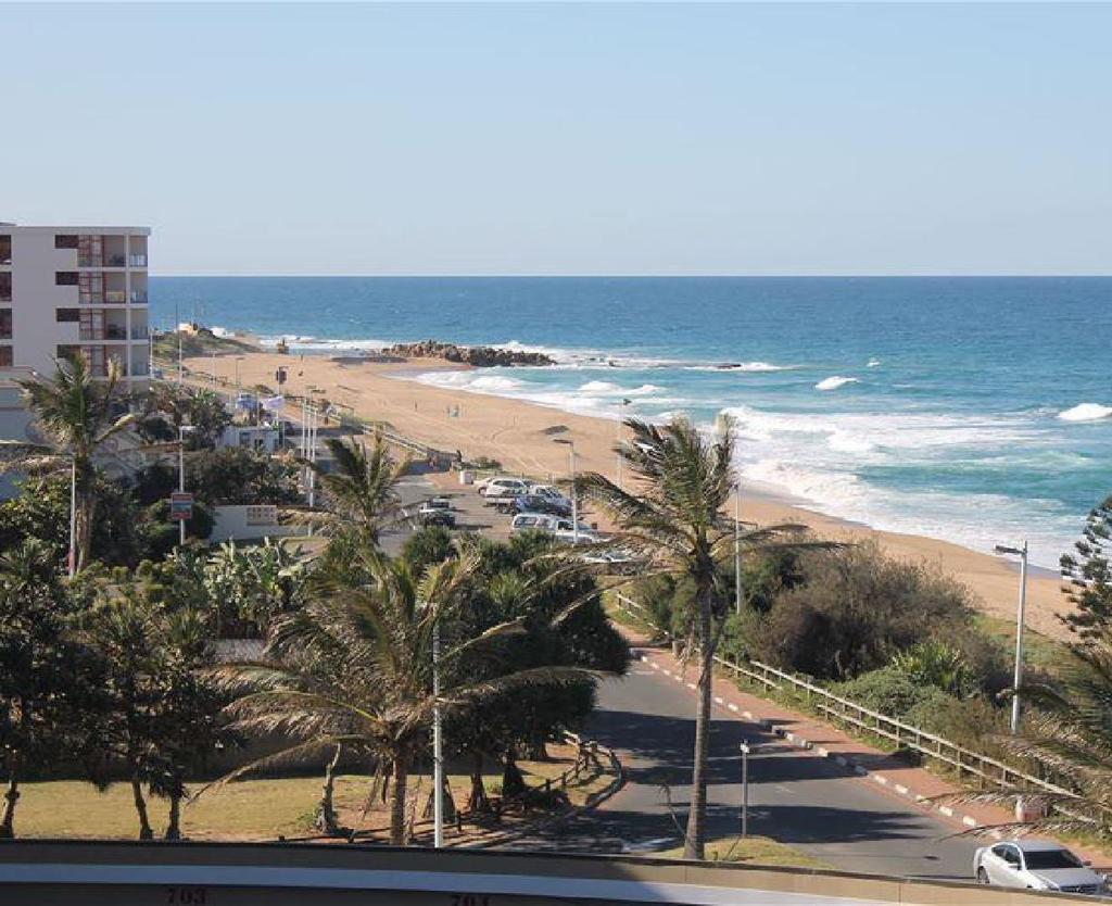
IMPROVEMENT PROJECT. emdloti... Jewel of the north coast, nestled between forest & sea. Prepared by: Pat Bean Terry Rens Tracey Simkiss
 IMPROVEMENT PROJECT emdloti... Jewel of the north coast, nestled between forest & sea. Prepared by: Pat Bean Terry Rens Tracey Simkiss 1 Our Vision We envision the area, from the emdloti river estuary
Official Community Plan Bylaw No. 4360, 2004, Amendment Bylaw No. 4897, 2016 (Sewell s Landing)
") District of West Vancouver Official Community Plan Bylaw No. 4360, 2004, Amendment Bylaw No. 4897, 2016 (Sewell s Landing) Effective Date: 1089612v1 District of West Vancouver Official Community Plan Bylaw
District of West Vancouver Official Community Plan Bylaw No. 4360, 2004, Amendment Bylaw No. 4897, 2016 (Sewell s Landing) Effective Date: 1089612v1 District of West Vancouver Official Community Plan Bylaw
H7 Open Space zones. (a) provide for the needs of the wider community as well as the needs of the community in which they are located;
 provide for the needs of the wider community as well as the needs of the community in which they are located;") H7. Open Space zones H7.1. Background The majority of land zoned as open space is vested in the Council or is owned by the Crown. However some areas zoned open space are privately owned. While the open
H7. Open Space zones H7.1. Background The majority of land zoned as open space is vested in the Council or is owned by the Crown. However some areas zoned open space are privately owned. While the open
Anatomy of A Vibrant Downtown. Anatomy of a Vibrant Downtown
 Anatomy of A Vibrant Downtown The goal of MAIN ST. REVITALIZATION PLANNING is to provide a framework that will help transform your downtown into a VIBRANT DOWNTOWN a place where people love to LIVE, WORK,
Lawrencetown Beach & Rainbow Haven Beach
 Lawrencetown Beach & Rainbow Haven Beach Public Engagement Session Wednesday, September 27 th, 2017 6:00pm 8:00pm Cole Harbour Place 51 Forest Hills Pkwy, Dartmouth Agenda Welcome & Introductions Overview
Lambeth Main Street Streetscape Improvements
 Lambeth Main Street Streetscape Improvements Open House October 5th, 2017 Agenda 1. Introduction 2. Project Background 3. Context 4. Project Objectives 5. Design Principles & Approach 6. Streetscape Design
Vu Kim Chi Nguyen Thi Thuy Hang
 Vu Kim Chi Nguyen Thi Thuy Hang Tokyo, Dec 7, 2015 Introduction Data and methods Results and discussions Conclusion The city of Quy Nhon Urban planning in Quy Nhon Climate change and sea level rise Natural
Riverfront Development Plan
 Planning Studies Project Overview: Continuity Developing Fort Myers underused riverfront was the final step in Downtown redevelopment. To mine all facets of the riverfront, the Plan had to be created cohesively
SQUAMISH 2010 AND BEYOND COMMUNITY VISION
 Our plan has been imagined and created to be both pragmatic and visionary. At the core of the strategy is a consideration of the highway s role and its impact on the community. First and foremost in creating
The University District envisions, in its neighborhood
 Envisioning the University District Link Light Rail in Seattle s neighborhoods CIY OF SEALE CONCEP-LEVEL SAION AREA PLANNING RECOMMENDAION RESOLUION # 30165 EXHIBI L Vision 08.2000 he University District
Sub-committee on Harbour Plan Review of Harbour-front Enhancement Committee. Ninth Meeting
 Sub-committee on Harbour Plan Review of Harbour-front Enhancement Committee Ninth Meeting Date: 5 October 2005 Time: 3:30pm Venue: Conference Room 15/F, North Point Government Offices, 333 Java Road, North
Overview Report. Proposed Development
 Overview Report Proposed Development the construction of a 1km cycle/pedestrian trail including a new footbridge, new car park and entrance road at Drumshanbo Lock and a new pedestrian/cycle road crossing,
CHAPTER 7: Transportation, Mobility and Circulation
 AGLE AREA COMMUNITY Plan CHAPTER 7 CHAPTER 7: Transportation, Mobility and Circulation Transportation, Mobility and Circulation The purpose of the Transportation, Mobility and Circulation Chapter is to
COMMUNITY ACTIONS for a SUSTAINABLE BARWON HEADS. February 2016
 COMMUNITY ACTIONS for a SUSTAINABLE BARWON HEADS February 2016 Acknowledgements Traditional Owners We acknowledge the traditional owners of this land and pay our respects to their elders past and present,
3.1 community vision. 3.3 required plan elements
 Chapter 3 Community Form 3.1 community vision 3.2 Parks & landscaping concepts 3.3 required plan elements D R A F T 20 Community Form Chapter 3 3.0 Community form 3.1 community vision The Specific Plan
Whitemarsh Comprehensive Plan Update: Housing & Land Use. Public Workshop #3: September 20, 2018
 Whitemarsh Comprehensive Plan Update: Housing & Land Use Public Workshop #3: September 20, 2018 Agenda Welcome Process Recap What We ve Heard The Plan Framework Review of Recommended Actions Land Use Housing
C. Westerly Creek Village & The Montview Corridor
 C. Westerly Creek Village & The VISION Community Vision When the goals of the city are achieved Westerly Creek Village, a distinctive community defined by Montview Boulevard and Westerly Creek, is a strong
North Oakville East Parks Facilities Distribution Plan. November, 2009
 North Oakville East November, 2009 POLICY CONTEXT 1) Purpose a) The purpose of this document is to be a guide for the location, configuration, design and development of the parks system for the North Oakville
Reconnecting to a Forgotten River St. Cloud MN. Aaron Hanson Design Design Thesis LA 572, Thesis, Spring 2012
 Reconnecting to a Forgotten River St. Cloud MN Aaron Hanson Design Design Thesis LA 572, Thesis, Spring 2012 site context 2.5 Miles Sartell St. Cloud to Fargo 170 Miles (2 hrs 45 mins) Hwy 10 infrastructure
THE 355/270 CORRIDOR:
 THE 355/270 CORRIDOR: Strategic Ideas for Sustaining a Livable Work Place Project Summary ACCESS LIFE DESIGN HEALTH WORK Montgomery County Planning Department The Maryland-National Capital Park and Planning
East Central Area Plan
 East Central Area Plan Steering Committee Meeting March 8 th, 2018 CHUN Tears McFarlane House Vision Statement Development Opportunities Analysis Vision Elements 1. Equitable, Affordable and Inclusive
PROPOSED REDEVELOPMENT OF THE GLEN ABBEY GOLF CLUB. STREETSCAPE DESIGN STUDY (excerpt from the Urban Design Brief) TOWN OF OAKVILLE.
 TOWN OF OAKVILLE.") PROPOSED REDEVELOPMENT OF THE GLEN ABBEY GOLF CLUB STREETSCAPE DESIGN STUDY (excerpt from the Urban Design Brief) TOWN OF OAKVILLE OCTOBER, 2016 for 2.4.2 STREETS Streets are the single largest component
PROPOSED REDEVELOPMENT OF THE GLEN ABBEY GOLF CLUB STREETSCAPE DESIGN STUDY (excerpt from the Urban Design Brief) TOWN OF OAKVILLE OCTOBER, 2016 for 2.4.2 STREETS Streets are the single largest component
Growing. Our masterplanning and urban design team is focused on addressing the complex issues affecting our towns, cities and neighbourhoods.
 Growing 1 We re passionate about creating healthy, vibrant urban environments where people want to live and visit, where they feel an active part of their communities and the public realm. (singular. a
City of Chickasaw Land Use Comprehensive Plan 2030 Chapter5-Draft(2)Public review_
Public review_") Land Use Land Use refers to the activity or development characteristics of a given parcel of land. The Land Use Plan presented in the following pages, represents the City of Chickasaw s official position
Land Use Land Use refers to the activity or development characteristics of a given parcel of land. The Land Use Plan presented in the following pages, represents the City of Chickasaw s official position
8. Urban Villages. Other Relevant Policies & Bylaws Official Community Plan Development Permit Area Designations and Guidelines
 8. Urban Villages Urban villages provide walkable shops and services, encourage a neighbourhood social life, create a sense of place and provide different housing options. More housing near Urban Villages
Building Ecological Solutions to Coastal Community Hazards: Guidance and NJ Coastal Community Assistance
 Building Ecological Solutions to Coastal Community Hazards: Guidance and NJ Coastal Community Assistance Stacy Small-Lorenz National Wildlife Federation Restore America s Estuaries Summit New Orleans,
ITEM #8. Regional Smart Growth Program. Regional Smart Growth Program. Presentation Overview. Coast Highway Vision and Stategic Plan.
 Regional Smart Growth Program Economic Development Commission What is Smart Growth? Adopted as part of the Regional Comprehensive Plan (RCP) RCP provides vision for region based on Smart Growth and sustainability
BUENOS AIRES: THE MICROCENTRO PLAN
 BUENOS AIRES: THE MICROCENTRO PLAN BUENOS AIRES THE MICROCENTRO PLAN Experiences and Lessons Learned _ Metropolis Meeting 2015 INCLUSION INNOVATION SUSTAINABILITY CONTENTS 1. Urban Context 2. Urban Design
Manchester. Vision for Manchester
 Manchester Vision for Manchester The Manchester Community Plan is a statement of the community values and aspirations for the future. This is an effort to recognize what originally attracted visitors in
Planning Commission Report
 Planning Commission Report To: From: Subject: Planning Commission Meeting: January 6, 2016 Agenda Item: 8-B Planning Commission David Martin, Planning & Community Development Director Introduction to the
Cambie Corridor Planning Program Phase Two Draft Plan. Standing Committee on City Services and Budgets May 5, 2011
 Cambie Corridor Planning Program Phase Two Draft Plan Standing Committee on City Services and Budgets May 5, 2011 Cambie Corridor Program Terms of Reference approved July 2009 Land Use Transportation Energy
3.3. Urban Structure Defining a New Hierarchy of Routes and Spaces >Images
 Section 3.0 I The Masterplan Framework 18 >Images Examples of high quality routes and spaces 3.3. Urban Structure The success of any masterplan lies in a clear definition of the future urban structure
EXISTING COMPREHENSIVE PLAN
 EXISTING COMPREHENSIVE PLAN Town Center Land Use Element: V. LAND USE POLICIES Town Center Mercer Island's business district vision as described in "Your Mercer Island Citizen-Designed Downtown" was an
K. SMART ASSOCIATES LIMITED
 Planning Justification Report Zoning By-Law Amendment 185 King Street North Waterloo, Ontario April 7th, 2017 Project Reference Number 16-245 K. SMART ASSOCIATES LIMITED CONSULTING ENGINEERS AND PLANNERS
Complete Neighbourhood Guidelines Review Tool
 Complete Neighbourhood Guidelines Review Tool Prepared By: City of Regina Planning Department October 2014 Page 1 of 14 Community Development Review Checklist for Secondary Plans and Concept Plans The
Pine Avenue Improvement Project
 Seaside Way to ocean Boulevard ocean Boulevard to 7 th Street 7 th Street to anaheim Street L O ng BeACh DeveLOpment ServiC e S Building a Better long Beach Pine Avenue Improvement Project Seaside Way
DOWNTOWN SIDNEY LOCAL AREA PLAN. urban design CHARRETTE REPORT 04 july 2008
 DOWNTOWN SIDNEY LOCAL AREA PLAN urban design CHARRETTE REPORT 04 july 2008 1.0 INTRODUCTION urban design is the art of making places. Successful downtown communities are places where people can live,
Pointe-Claire Community Destination
 Pointe-Claire Community Destination Lester John Vidal Sarah Gregoire-Caucci Gabriel Van Beverhoudt APRIL 2011 Table of Content 1. Executive Summary Problems & Solutions Current State Approach 2. Program
Case studies. B1.1 Lloyds Crossing, Portland (USA)
") B. Case Studies 57 B1 Case studies B1.1 Lloyds Crossing, Portland (USA) Lloyds Crossing in Portland is a brownfields redevelopment site in the central city area, with the aim of: Developing a conceptual
B. Case Studies 57 B1 Case studies B1.1 Lloyds Crossing, Portland (USA) Lloyds Crossing in Portland is a brownfields redevelopment site in the central city area, with the aim of: Developing a conceptual
Planning for Staten. Habitat Restoration and Green Infrastructure. Island s North Shore
 Habitat Restoration and Green Infrastructure Planning for Staten Island s North Shore Community Board 1 March 1, 2018 NYC Parks Forestry, Horticulture, and Natural Resources Funded by the NYS Department
LUNDY S LANE COMMUNITY IMPROVEMENT PLAN STUDY
 PUBLIC INFORMATION MEETING #2 October 12, 2016 LUNDY S LANE COMMUNITY IMPROVEMENT PLAN STUDY AGENDA 5:00 to 5:30pm: Open House 5:30 to 6:15pm: Presentation 6:15 to 7:00pm: Individual paced workshop with
SH1 - Causeway, Auckland, 2014 (Source: NZ Transport Agency)
") SH1 - Causeway, Auckland, 2014 (Source: NZ Transport Agency) Coastal effects assessment guide Environmental and social responsibility policy State highway environmental plan Transport Agency statement
SH1 - Causeway, Auckland, 2014 (Source: NZ Transport Agency) Coastal effects assessment guide Environmental and social responsibility policy State highway environmental plan Transport Agency statement
City of Farmington. Downtown Plan. Amendment to the 1998 Master Plan Adopted October 11, 2004
 City of Farmington Amendment to the 1998 Master Plan Adopted October 11, 2004 Introduction Planning Background 1 Scope and Components of the Plan Amendment 2 Concept Introduction 3 Plan Concepts 3 Conceptual
A. INTRODUCTION B. CUMULATIVE EFFECTS ANALYSIS
 Chapter 4: Cumulative Effects A. INTRODUCTION The New York City Department of Parks and Recreation plans to reconstruct the Rockaway Beach Boardwalk in the borough of Queens, New York City, which Hurricane
THE CIVIC DISTRICT DEVELOPMENT OPPORTUNITIES
 1 THE CIVIC DISTRICT DEVELOPMENT OPPORTUNITIES The Civic District is the physical and emotional heart of the downtown. It is also a major gateway into the central core, establishing the image and identity
ROCKAWAY BOARDWALK Community Board 14 Parks Committee Meeting June 4, 2014
 ROCKAWAY BOARDWALK Community Board 14 Parks Committee Meeting June 4, 2014 Introduction 2 Agenda Design Update Construction Update Local Hiring Update 3 Community Input 7 Meeting Date September 17, 2013
Severn Estuary Shoreline Management Plan What does it mean for planning in North Somerset?
 Severn Estuary Shoreline Management Plan What does it mean for planning in North Somerset? Coastal planning The National Planning Policy Framework sets out the Government s planning policies for England.
PROPOSED URBAN STRUCTURE
 CHAPTER 3 PROPOSED URBAN STRUCTURE PLANNING PARTNERS: CENTURY CITY URBAN DESIGN FRAMEWORK October 2005 13 THE PROPOSED URBAN STRUCTURE The urban design rationale outlined in the previous chapter provides
Proposals for the regeneration of Standard Quay, Faversham, Kent
 Proposals for the regeneration of Standard Quay, Faversham, Kent The purpose of this information is to explain the progress in regenerating Standard Quay and to outline proposals with indicative timescales
REVIEW AND EVALUATION OF REGIONAL LAND USE
 REVIEW AND EVALUATION OF REGIONAL LAND USE AND TRANSPORTATION SCENARIOS #220831 Environmental Justice Task Force October 7, 2014 VISION 2050 Process Development of Guiding Vision for Land Use and Transportation