Infrastructure, Development and Enterprise Services
|
|
|
- Jonah Hubbard
- 5 years ago
- Views:
Transcription

1 Staff Report To Service Area City Council Infrastructure, Development and Enterprise Services Date Monday, September 10, 2018 Subject Report Number Decision Report Janefield Avenue Official Plan and Zoning By-law Amendments File: OP1702/ZC1702 Ward 5 IDE Recommendation 1. That the application by Astrid J. Clos Planning Consultants on behalf of Benedetto Di Renzo and Mario Antonio Di Renzo, for approval of an Official Plan Amendment on a portion of the site from the Medium Density land use designation to the High Density designation to permit a high density residential development on the properties municipally known as Janefield Avenue and legally described as Part of Block L, Registered Plan 649; Geographic Township of Guelph, City of Guelph be approved, in accordance with ATT-2 of the Infrastructure, Development and Enterprise Report IDE , dated September 10, That the application by Astrid J. Clos Planning Consultants on behalf of Benedetto Di Renzo and Mario Antonio Di Renzo, for approval of a Zoning By-law Amendment from the R.4A-1 (Specialized Residential Apartment) Zone with and SC.1-4 (Specialized Service Commercial) Zone to an R.4B-?? (Specialized High Density Residential) Zone to permit the development of a 10 storey, 165 unit high density residential development on the properties municipally known as Janefield Avenue and legally described as Part of Block L, Registered Plan 649; Geographic Township of Guelph, City of Guelph be approved, in accordance with ATT-3 of the Infrastructure, Development and Enterprise Report IDE , dated September 10, That in accordance with Section 34(17) of the Planning Act, City Council has determined that no further public notice is required related to the minor modifications to the proposed Zoning By-law Amendment affecting Janefield Avenue. Page 1 of 63
2 Executive Summary Purpose of Report This report provides a staff recommendation to approve Official Plan and Zoning Bylaw Amendments to permit the development of a 10 storey, 165 unit, high density residential development on the site municipally known as Janefield Avenue. Key Findings Planning staff support the proposed Official Plan and Zoning By-law Amendment subject to the regulations and conditions in ATT-3. Financial Implications Estimated Development Charges: $2,615,000 based on 2018 rates. Estimated Annual Taxes: $213,000 Report Background Applications for an Official Plan Amendment and a Zoning By-law Amendment were received for the property municipally known as Janefield Avenue on May 3, 2017 and deemed complete on June 1, The original proposal was for a 12 storey, high density residential development containing approximately 185 residential units. A statutory public meeting was held on July 10, At this Public Meeting Council several area residents raised concerns about the proposal, including height, density and access. The applicant reviewed these concerns together with staff comments and submitted a revised application on February 12, The revised application reduced the building height to 10 storeys, shortened the building on the westerly side and reduced the number of dwelling units to a total of 165 residential units. A second Public Meeting was held on May 14, 2018 to discuss the revised application. At this public meeting, area residents still had concerns primarily with traffic, height and compatibility with the surrounding area. Location The subject lands are located on the south side of Janefield Avenue, north of Stone Road West, west of Scottsdale Drive and east of the Hanlon Parkway (see Location Map and Orthophoto in ATT-1). The site is approximately 1.1 hectares in size and is vacant. Surrounding land uses include: A stacked townhouse development on the north side of Janefield Avenue, directly across from the subject site; A commercial plaza is located at the intersection of Janefield and Scottsdale Drive, east of the subject site; Page 2 of 63
3 Holiday Inn Guelph Hotel & Conference Centre is located at the intersection of Scottsdale Drive and Stone Road West; which is to the south of the subject site; Two Religious establishments, Priory Park Baptist and Jehovah s Witness, are south west and adjacent to the subject site; and A single detached dwelling at the intersection of Janefield Avenue and Torch Lane which is to the west of the site. Official Plan Land Use Designations and Policies The application was received prior to the City s new Official Plan (OPA#48) coming into full force and effect, so the policies of the previous Official Plan (City of Guelph Official Plan 2001, September 2014 Consolidation) are applied to the review of this application. The land use designations that apply to the subject property are Medium Density Residential and Intensification Area. Medium Density Residential permits multipleunit residential buildings, such as townhouses, row dwellings and walk-up apartments. The net density of development shall be a minimum of 20 units per hectare and a maximum of 100 units per hectare. The intent of the Intensification Area designation is to promote the intensification and revitalization of existing well defined commercial nodes in order to efficiently use the land by grouping complementary uses in close proximity to one another providing the opportunity to satisfy several shopping and service needs at one location. Implementing zoning by-laws may include mechanisms such as minimum density requirements and maximum parking standards to promote the efficient use of the land base. The intensification area is intended to provide a wide range of retail, services, office, entertainment and recreational commercial uses as well as complementary uses including open space, institutional, cultural and educational uses, hotels and live-work studios. Medium and high density multiple unit residential development and apartments shall also be permitted in accordance with the policies of Section 7.2. The relevant policies are included in ATT-4. Official Plan Amendment #48 Land Use Designations and Policies Official Plan Amendment #48 (OPA 48) came into effect in October 2017, and is a comprehensive update to the City s Official Plan. It designates the subject property as Mixed Use Corridor and Medium Density Residential. The permitted uses under the Medium Density Residential include multiple unit residential buildings, such as townhouses and apartments. The minimum building height is two (2) storeys and the maximum height is six (6) storeys with a density range of 35 to 100 units per hectare. The Mixed-use Corridor designation is intended to serve both the needs of residents living and working in-site in nearby neighbourhoods and employment districts and the wider City as a whole. The objectives: to promote the continued economic viability, intensification, diversity of uses and revitalization of the Mixed-use Corridor; to promote a distinctive and high standard of building and landscape design for Mixed-use Corridors; to ensure that the development of Mixed-use Page 3 of 63
4 Corridors occurs in a cohesive, complementary and coordinated manner. Freestanding residential development is permitted in this designation with a permitted density range of units per hectare. Although the application is being processed under the 2001 Official Plan, staff must have regard to the Council adopted policies and designations of OPA 48. The land use designations and relevant policies contained in OPA 48 are included in ATT-5. Description of the Proposed Official Plan Amendment The applicant is requesting to amend the Official Plan by redesignating the portion of the subject lands that currently have a Medium Density Residential land use designation to a High Density Residential land use designation, which would have a maximum residential density of 150 units per hectare, similar to the existing Mixed Use Corridor designation on the easterly half of the site. The recommended Official Plan Amendment is included in ATT-2. Existing Zoning The subject property is currently zoned R.4A-1 (Residential Apartment) Zone with specialized regulations and SC.1-4 (Service Commercial) Zone with specialized regulations in the City of Guelph s Zoning By-Law No. (1995) The existing zoning is included in ATT-6. Description of Proposed Zoning By-law Amendment The applicant has requested to rezone the subject lands from the R.4A-1 (Residential Apartment) Zone and SC.1-4 (Service Commercial) Zone in the Guelph Zoning By-law to the R.4B (High Density Residential Apartment) Zone to permit the development of a residential building with a maximum height of 10 storeys and a total of 165 residential units. No specialized regulations were requested by the applicant for this zone. While no specialized regulations are required to build the development as proposed, to better address some of the concerns from neighbouring residents, planning staff have recommended some site specific regulations be added to the site to further ensure that the development is built as proposed. The following site specific regulations are being recommended by staff: A 35 degree angular plane setback from Torch Lane to the building A 30 metre building setback from Torch Lane A greater minimum side yard setback of 15 metres from the westerly interior side lot line adjacent to the Priory Park Baptist Church A height limit of 8 storeys on the westerly portion of the site, within 30 metres of the westerly interior side lot line. A maximum building length of 65 metres above the second storey That the building must stepback a minimum of 6 metres above the 9 th storey from the edge of the building facing the easterly interior lot line. The proposed zoning is shown in ATT-7. Page 4 of 63
5 Original Development Proposal (May 2017) The original development proposal for the site, from May 2017, consisted of one 'L' shaped residential building with varying heights of 12, 10 and 5 storeys, containing approximately 185 residential units. The applicant applied for a site specific Official Plan amendment to permit a density of 168 units per hectare and a site specific high density residential zone (R.4B-?) with specialized regulations for reduced common amenity area, increased density, increased Floor Space Index, reduced side yard setback and increased building height to 12 storeys. See ATT-8 for initial site concept plan and building elevations. Current Development Proposal The applicant s revised submission is for one residential building containing 165 residential units, that is still L shaped, with 10 storeys in the higher portion of the building on the easterly side of the site, then 8 storeys in the westerly portion, with a 2 storey high podium in the centre joining the two sections. The driveway access has been removed from Torch Lane and now a single site access is located on the east side of the building onto Janefield Avenue. The outdoor amenity area has been relocated to provide a larger building setback and buffer to the existing religious establishments and the single-detached dwelling on Torch Lane. A total of 212 parking spaces are provided and 121 of those spaces are located in two levels of underground parking. The current conceptual development plan and proposed building elevations are shown in ATT-9. Staff Review/Planning Analysis The staff review and planning analysis for this application is provided in ATT-10. The analysis addresses all relevant planning considerations, including the issues that were raised by Council and members of the public at the statutory Public Meetings held on July 10, 2017 and May 14, Staff Recommendation Planning staff are satisfied that the Official Plan Amendment Application and Zoning By-law Amendment Application are both consistent with the 2014 Provincial Policy Statement and conform to the Growth Plan for the Greater Golden Horseshoe. The applications conform to the objectives and policies of the Official Plan. Proposed OPA 68 to redesignate the Medium Density Residential portion of the site to High Density Residential meets the policies of the 2001 Official Plan, in effect at the time of application as well as OPA 48 in effect today. The applicant has made a number of minor modifications to the proposed development in response to comments received since initially submitting the applications. Additional and modified specialized zoning regulations are also being recommended by staff that were not identified at the Statutory Public meeting. However, the modifications to the development layout and the addition of specialized zoning regulations as recommended by staff are considered to be minor and therefore staff recommend that no further public notice is required in accordance with Section 34(17) of the Planning Act. Page 5 of 63
6 Planning staff are recommending that Council approve the applications for an Official Plan Amendment and Zoning By-law Amendment subject to the conditions and zoning regulations outlined in ATT-3. Financial Implications Estimated Development Charges: $2,615,000 based on 2018 rates Estimated Annual Taxes: $213,000 Consultations The public agency and comments received from City departments during the review of the application are summarized in ATT-13. Key dates for the public process regarding the planning application are included in ATT-14. Corporate Administrative Plan This report supports the following goals and work plans of the Corporate Administrative Plan ( ): Overarching Goals Service Excellence Service Area Operational Work Plans Our People- Building a great community together Attachments ATT-1 Location Map (120 metre circulation) and Orthophoto ATT-2 Recommended Official Plan Amendment No. 68 ATT-3 Recommended Zoning Regulations and Conditions ATT-4 Official Plan Land Use Designations and Policies ATT-6 Existing Zoning ATT-7 Proposed Zoning ATT-8 Initial Site Concept Plan and Building Elevations ATT-9 Revised Site Concept Plan and Building Elevations ATT-10 Planning Analysis ATT-11 Community Energy Initiative Commitment Letter ATT-12 Urban Design Peer Review Summary ATT-13 Departmental and Agency Comments Summary ATT-14 Public Notification Summary Page 6 of 63
7 Departmental Approval Not applicable. Report Author Katie Nasswetter Senior Development Planner Approved By Chris DeVriendt Manager of Development Planning for Approved By Recommended By Todd Salter Scott Stewart, C.E.T. General Manager Deputy CAO Planning, Urban Design and Infrastructure, Development and Enterprise Building Services , ext , ext Page 7 of 63

8 ATT-1 Location Map and 120m Circulation Page 8 of 63

9 ATT-1 (continued) Orthophoto Page 9 of 63
10 ATT-2 Recommended Official Plan Amendment No. 68 O.P.A. #68: The purpose of Official Plan Amendment #68 is to redesignate the Medium Density Residential portion of the property municipally known as Janefield Avenue and legally described as Part of Block L, Registered Plan 649; Geographic Township of Guelph, City of Guelph, to the High Density Residential designation to permit a high density residential apartment development. Page 10 of 63
11 ATT-3 Recommended Zoning Regulations and Conditions Part A: Zoning Regulations Zoning By-law Amendment The following zoning is proposed: Specialized R.4B-?? (High Density Residential Apartment) Zone Regulations In accordance with Section 4 (General Provisions) and Section 5.4 and Table (Regulations Governing R.4 Zones) of Zoning By-law (1995)-14864, as amended, with the following exceptions: Minimum Westerly Side Yard Notwithstanding Table 5.4.2, Row 8, the westerly interior side yard shall be a minimum of 15 metres wide. Maximum Building Height Notwithstanding Table 5.4.2, Row 10, the maximum Building Height shall be limited to 8 storeys within 30 metres of the westerly interior side lot line. Angular Plane from Torch Lane In addition to Table 5.4.2, Row 8 and Section 4.16, Building Height shall not exceed an angular plane of 35 degrees projected from the Centre Line of Torch Lane. Setback from Torch Lane Notwithstanding Table 5.4.2, Row 6, the minimum exterior side yard fronting onto Torch Lane shall be 30 metres. Maximum Building Length That a maximum building length of 65 metres be permitted above the second storey. Built Form Stepback That the building must stepback a minimum of 6 metres above the 9 th storey from the edge of the building facing the easterly interior side lot line. Part B: Proposed Conditions The following conditions are provided as information to Council and will be imposed through site plan approval with the City, and may be registered in an agreement on title for the subject lands. Page 11 of 63
12 1. That the Developer shall submit to the City, in accordance with Section 41 of The Planning Act, a fully detailed site plan, indicating the location of the building, building design, landscaping, parking, traffic circulation, access, lighting, grading and drainage on the said lands to the satisfaction of the General Manager of Planning and the General Manager/City Engineer, prior to any construction or grading on the lands. a. Further, the Owner commits and agrees that the details of the layout and design for the development of the subject lands shall be generally in conformance with the development concept plan and renderings attached as ATT-9 to the September 10, 2018 Planning, Urban Design and Building Services Report Number IDE ; b. Further, the Owner shall implement the recommendations of the Urban Design Brief, dated May 17, 2018, together with the addenda package submitted July 30, 2018, by MCL Architects and the Urban Design Peer Review Summary Letter included in ATT-12 of Report IDE to the satisfaction of the General Manager of Planning, Urban Design and Building Services. 2. Prior to the issuance of site plan approval, the Owner shall provide the City with written confirmation that the building on the subject site will be constructed to a standard that implements energy efficiency in order to support the Community Energy Initiative to the satisfaction of the General Manager of Planning, Urban Design and Building Services and in accordance with the letter attached as ATT-11 to Report IDE dated September 10, Prior to the issuance of site plan approval, written confirmation shall be received from the General Manager of Environmental Services or his or her designate that the proposed development is in conformance with By-law (2011)-19199, known as the Waste Management By-law. Further, the Owner agrees and commits to employ a three-stream waste collection system with considerations and opportunities developed in their Waste Management Plan that would facilitate the transition to City collection at some point in the future. 4. The Owner shall pay to the City, as determined applicable by the Chief Financial Officer/City Treasurer, development charges and education development charges, in accordance with the City of Guelph Development Charges By-law (2009)-18729, as amended from time to time, or any successor thereof, and in accordance with the Education Development Charges By-laws of the Upper Grand District School Board (Wellington County) and the Wellington Catholic District School Board, as amended from time to time, or any successor by-laws thereof, prior to this issuance of any building permits, at the rate in effect at the time of the issuance of a building permit. Page 12 of 63
13 5. The Developer shall obtain a Site Alteration Permit in accordance with City of Guelph By-law (2007) to the satisfaction of the City Engineer if grading/earthworks are to occur prior to the approval of the required engineering studies, plans and reports. 6. The Developer shall prepare and implement a construction traffic access and control plan for all phases of servicing and building construction to the satisfaction of the City Engineer. Any costs related to the implementation of such a plan shall be borne by the Developer. 7. Prior to site plan approval and prior to any construction or grading on the lands, the owner shall provide to the City, to the satisfaction of the General Manager/City Engineer, any of the following studies, plans and reports that may be requested by the General Manager/City Engineer:- a. a functional servicing report; b. a stormwater management report and plans certified by a Professional Engineer in accordance with the City s Guidelines and the latest edition of the Ministry of the Environment s "Stormwater Management Practices Planning and Design Manual" which addresses the quantity and quality of stormwater discharge from the site together with a monitoring and maintenance program for the stormwater management facility to be submitted; This stormwater management report is to demonstrate how the site will achieve a post-development groundwater recharge that is equal to the pre-development recharge. On-site permeameter testing is required to confirm that the recharge can be achieved, provide the City with the seasonal high groundwater data. c. a geotechnical report certified by a Professional Engineer that analysis the permeability and hydraulic conductivity of the soils and recommends measures to ensure that they are not diminished by the construction and development; d. a grading, drainage and servicing plan prepared by a Professional Engineer for the site and detailed erosion and sediment control plan, certified by a Professional Engineer that indicates the means whereby erosion will be minimized and sediment maintained on-site throughout grading and construction. e. An updated Phase I ESA report or letter should also include a Reliance Letter from a QP to indicate that despite any limitations or qualifications included in the report, the City is authorized to rely on all information and opinion provided in the report. 8. The Developer shall, to the satisfaction of the General Manager/City Engineer, address and be responsible for adhering to all the recommended measures contained in the plans, studies and reports outlined in subsections 7 i) to 7 iv) inclusive. 9. That the Developer will ensure that any existing domestic wells as well as all boreholes and monitoring wells installed for environmental, hydrogeological or geotechnical investigations are properly decommissioned in accordance with current Ministry of the Environment regulations (O.Reg. 903 as Page 13 of 63
14 amended) and to the satisfaction of the General Manager/City Engineer, prior to site plan approval and prior to any construction or grading on the lands. 10. The Developer acknowledges that the City does not allow retaining walls higher than 1.0-metre abutting existing residential properties without the permission of the General Manager/City Engineer. 11. The Developer shall be responsible for the actual cost of any service laterals required for the lands and furthermore, prior to any grading or construction on the lands the Developer shall pay to the City, the estimated cost as determined by the General Manager/City Engineer of any service laterals. 12. That the Developer pay the actual cost of removing or decommissioning to the satisfaction of the General Manager/City Engineer, any existing sanitary sewers, storm sewers, manhole and/or watermains that are not going to be used for service laterals. Furthermore, prior any grading or construction on the lands, the Developer shall pay to the City, the estimated cost as determined by the General Manager/City Engineer of the Developer s share of the cost of the removals and decommissioning works. 13. The Developer shall pay to the City the actual cost of the construction of the new driveway entrance and required curb cut and/or curb fill. Furthermore, prior to any grading or construction on the lands, the Developer shall pay to the City, the estimated cost as determined by the General Manager/City Engineer of the construction of the new driveway entrance and required curb cut and/or curb fill. 14. The Developer shall pay the actual cost of the removal of the existing driveway entrance including the asphalt pavement and gravel within the road allowance, the restoration of the boulevard with topsoil and sod including the required curb fill, with the estimated cost of the works as determined by the General Manager/City Engineer being paid, prior to any grading or construction on the lands. 15. The developer shall submit for review a Noise Study completed by a qualified Professional Engineer and implement/incorporate any noise and/or vibration attenuation measures and warning clauses recommended in the Noise Study completed by a qualified Professional Engineer, to the approval of the General Manager/City Engineer. 16. That all electrical services to the subject property are underground and the Owner shall make satisfactory arrangements with Guelph Hydro Electric Systems Inc. for the servicing of the subject property, as well as provisions for any easements and/or rights-of-way for their plants, prior to site plan approval and prior to any construction or grading on the lands. Page 14 of 63
15 17. The Developer shall agree that adequate sidewalks, lighting and snow removal (on private sidewalks and walkways on the subject lands) will be provided to allow children to walk safely to school or to a designated bus pickup point. 18. The Developer shall agree to advise all purchasers of residential units and/or renters of same, by inserting the following clauses in all offers of Purchase and Sale/Lease: a. In order to limit liability, public school buses operated by the Service de transport de Wellington-Dufferin Student Transportation Services (STWDSTS), or its assigns or successors, will not travel on privately owned or maintained right-of-ways to pick up students, and potential busing students will be required to meet the bus at a congregated bus pick-up point. Page 15 of 63

16 ATT-4 Official Plan Land Use Designations and Policies Page 16 of 63
17 ATT-4 (continued) Official Plan Land Use Designations and Policies Multiple unit residential buildings, such as townhouses, row dwellings and apartments, may be permitted within designated areas permitting residential uses. The following development criteria will be used to evaluate a development proposal for multiple unit housing: a) That the building form, massing, appearance and siting are compatible in design, character and orientation with buildings in the immediate vicinity; b) That the proposal can be adequately served by local convenience and neighbourhood shopping facilities, schools, parks and recreation facilities and public transit; c) That the vehicular traffic generated from the proposal can be accommodated with minimal impact on local residential streets and intersections and, in addition, vehicular circulation, access and parking facilities can be adequately provided; and d) That adequate municipal infrastructure, services and amenity areas for the residents can be provided. 'Medium Density Residential' Land Use Designation The predominant use of land within areas designated as 'Medium Density Residential' on Schedule 1 shall be for multiple unit residential buildings, such as townhouses, row dwellings and walk-up apartments. It is not intended that housing forms such as single detached or semidetached units shall be permitted. Residential care facilities and lodging houses may be permitted by the provisions of this Plan. a) Within the Medium Density Residential designation at the northeast side of the intersection of York Road and Wyndham Street South, detached and semi-detached housing forms are permitted with frontage onto York Road, Wyndham Street South and Richardson Street provided that the overall density of development within the Medium Density Residential designation in this location complies with Section The 'Medium Density Residential' designation has been outlined on Schedule 1 in instances where there is a clear planning intent to provide for the following: a) Medium density housing forms in new growth areas to assist in providing opportunities for affordable housing; Page 17 of 63
18 b) Greater housing densities that are supportive of transit usage adjacent to major roads forming the existing and future transit network; c) A variety of housing types and forms to be situated throughout all areas of the community; and d) Supportive of urban form objectives and policies to establishing or maintaining mixed-use nodes The net density of development shall be a minimum of 20 units per hectare (8 units/acre) and a maximum of 100 units per hectare (40 units/acre), except as provided for in policy Medium density residential development proposals shall generally comply with criteria established for multiple unit residential buildings in policy of this Plan, and shall be regulated by the Zoning Bylaw In addition to being permitted on land designated Medium Density Residential, multiple unit residential buildings may be permitted without an amendment to this Plan on land designated General Residential where such proposals generally comply with the criteria in policy Intensification Areas The Intensification Areas designation identified on Schedule 1 in this Plan is comprised of one or several individual developments on one or more properties within a "node", and is intended to serve both the needs of residents living and working in nearby neighbourhoods and employment districts and the wider City as a whole The intent of the Intensification Area designation is to promote the intensification and revitalization of existing well defined commercial nodes in order to efficiently use the land base by grouping complementary uses in close proximity to one another providing the opportunity to satisfy several shopping and service needs at one location. Implementing zoning by-laws may include mechanisms such as minimum density requirements and maximum parking standards to promote the efficient use of the land base It is intended that where there are adjacent properties within the node that as new development occurs the lands will be integrated with one another in terms of internal access roads, entrances from public streets, access to common parking areas, grading, open space and storm water management systems. Furthermore, it is intended that individual developments within the Intensification Node will be designed to be integrated into the wider community by footpaths, Page 18 of 63
19 sidewalks and bicycle systems and by the placement of smaller buildings amenable to the provision of local goods and services in close proximity to the street line near transit facilities The boundaries of the Intensification Area designation are intended to clearly distinguish the node as a distinct entity from adjacent land use designations. Subject to the policies of section 9.2, proposals to expand an Intensification Area beyond these boundaries shall require an Official Plan Amendment supported by impact studies as outlined in policies to The Intensification Area is intended to provide a wide range of retail, service, office, entertainment and recreational commercial uses as well as complementary uses including open space, institutional, cultural and educational uses, hotels, and live-work studios. Medium and high density multiple unit residential development and apartments shall also be permitted in accordance with the policies of Section The permitted uses can be mixed vertically within a building or horizontally within multiple-unit mall buildings or may be provided in free-standing individual buildings. Where an individual development incorporates a single use building in excess of 5,575 square metres (60,000 sq. ft) of gross leasable floor area, the site shall also be designed to provide the opportunity for smaller buildings amenable to the provision of local goods and services to be located near intersections and immediately adjacent to the street line near transit facilities. These smaller buildings shall comprise a minimum of 10% of the total gross leasable floor area within the overall development The City will require the aesthetic character of site and building design to be consistent with the City s urban design objectives and guidelines and shall incorporate measures into the approval of Zoning By-laws and site plans used to regulate development within the Intensification Area designation to ensure such consistency. Page 19 of 63

20 ATT-5 Official Plan Amendment #48 Land Use Designations and Policies Page 20 of 63
21 ATT-5 (continued) Official Plan Amendment #48 Land Use Designations and Policies Medium Density Residential The use of land within the Medium Density Residential Designation will be medium density housing forms. Permitted Uses 1. The following uses may be permitted subject to the applicable provisions of this Plan: i) multiple unit residential buildings, such as townhouses and apartments. Height and Density 2. The minimum height is two (2) storeys and the maximum height is six (6) storeys. 3. The maximum net density is 100 units per hectare and not less than a minimum net density of 35 units per hectare. 4. Increased height and density may be permitted in accordance with the Height and Density Bonus policies of this Plan Mixed-use Corridor The Mixed-use Corridor designation is intended to serve both the needs of residents living and working on-site, in nearby neighbourhoods and employment districts and the wider City as a whole. The following Mixed-use Corridors are designated on Schedule 2: Silvercreek Parkway Mixed-use Corridor Eramosa Mixed-use Corridor Stone Road Mixed-use Corridor. Objectives a) To promote the continued economic viability, intensification, diversity of uses and revitalization of the Mixed-use Corridor. b) To promote a distinctive and high standard of building and landscape design for Mixed-use Corridors. c) To ensure that the development of Mixed-use Corridors occurs in a cohesive, complementary and coordinated manner. Policies 1. The Mixed-use Corridor designation promotes the intensification and revitalization of existing well-defined commercial corridors to efficiently use the land base by grouping complementary uses in close proximity to one another providing Page 21 of 63
22 the opportunity to satisfy several shopping and service needs and residential use at one location. Implementing Zoning By-laws may include mechanisms such as minimum density requirements, heights and maximum parking standards to promote the efficient use of the land base. 2. Where new development occurs within the corridor, adjacent lands will be integrated with one another in terms of internal access roads, entrances from public streets, access to common parking areas, grading, open space and urban squares and stormwater management systems. 3. Furthermore, individual developments within the Mixed-use Corridor will be designed to be integrated into the wider community by footpaths, sidewalks and the Bicycle Network and by the placement of multi-storey buildings amenable to the provision of local goods and services in close proximity to the street line near transit facilities. 4. Development within the Mixed-use Corridor will address the adjacent arterial or collector road and will be planned and designed to: i) front multi-storey buildings onto arterial or collector roads; ii) provide for ground floor retail and service uses; and iii) provide for a rhythm and spacing of building entrances and appropriately sized store fronts to encourage pedestrian activity. 5. The City will require the aesthetic character of site and building design to be consistent with the Urban Design policies of this Plan and shall incorporate measures into the approval of Zoning by-laws and Site Plans used to regulate development within the Mixed-use Corridor designation to ensure such consistency. 6. The boundaries of the Mixed-use Corridor designation are intended to clearly distinguish the area as a distinct entity from adjacent land use designations. Proposals to expand a Mixed-use Corridor beyond these boundaries shall require an Official Plan Amendment supported by a Market Impact Study. Permitted Uses 7. The following uses may be permitted in the Mixed-use Corridor designation, subject to the applicable provisions of this Plan: i) commercial, retail and service uses; ii) office; iii) entertainment and recreational commercial uses; iv) cultural and educational uses; v) institutional uses; vi) hotels; vii) live/work; viii) medium and high density multiple unit residential buildings and apartments; and ix) urban squares and open space. Page 22 of 63
23 8. The permitted uses can be mixed vertically within a building or horizontally within multiple-unit mall buildings or may be provided in free-standing individual buildings. Where an individual development incorporates a single use building in excess of 5,575 square metres (60,000 sq. ft.) of gross floor area, the site shall also be designed to provide the opportunity for smaller buildings amenable to the provision of local goods and services to be located near intersections and immediately adjacent to the street line near transit facilities. These smaller buildings shall comprise a minimum of 10% of the total gross floor area within the overall development. Height and Density 9. The maximum height is six (6) storeys. 10. For freestanding residential development, the maximum net density is 150 units per hectare and the minimum net density is 100 units per hectare. 11. Additional height and density may be permitted subject to the Height and Density Bonus provisions of this Plan. Page 23 of 63

24 ATT-6 Existing Zoning Page 24 of 63

25 ATT-7 Proposed Zoning and Details Page 25 of 63

26 ATT-7 (continued) Proposed Zoning and Details Standard R.4 Apartment Zone Regulation Summary Table Page 26 of 63
27 ATT-8 Initial Site Concept Plan and Building Elevations (May 2017) Page 27 of 63

 Page 28 of")
28 ATT-8 (continued) Initial Building Elevations (May 2017) Page 28 of 63
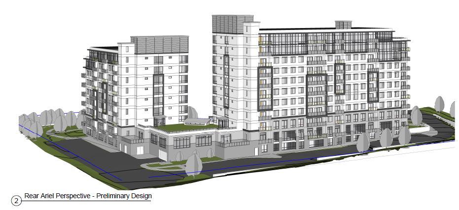
29 ATT-9 Revised Site Concept Plan and Building Elevations 8 STOREYS 2 STOREYS 10 STOREYS Page 29 of 63
")

30 ATT-9 (continued) Revised Building Elevations Page 30 of 63

31 Page 31 of 63
32 ATT-10 Staff Review and Planning Analysis 2014 Provincial Policy Statement The 2014 Provincial Policy Statement (PPS) provides direction on matters of provincial interest related to land use planning and development and is issued under the authority of Section 3 of the Planning Act. In general, the PPS promotes efficient use of land and development patterns and addresses matters of provincial interest in land use planning. As per section 4.2, all planning decisions shall be consistent with the PPS. Policy Section 1.0 Building Strong Healthy Communities speaks to efficient land use and development patterns to support sustainability by promoting strong, liveable, healthy and resilient communities, protecting the environment and public health and safety, and facilitating economic growth. Policy of the PPS promotes creating and sustaining healthy, liveable and safe communities. This is achieved in part by promoting efficient development and land use patterns with an appropriate range and mix of residential and employment and other uses to meet long term needs [1.1.1 a), b)]. Also, development must avoid land use patterns that may cause environmental concerns, and be cost-effective, ensuring the necessary infrastructure is in place to meet the projected needs [1.1.1 c), e), g)]. Policy requires development in settlement areas to use land and resources wisely, considering opportunities for intensification and redevelopment. Specifically, densities are to be appropriate for and efficiently utilize the infrastructure and public service facilities that are planned or available. In addition, land use and development patterns in settlement areas are to be efficient, transit supportive and take into account existing building stock [ , a), b), ]. Appropriate development standards are to be promoted, facilitating intensification and a compact built form, while mitigating risks to public health and safety [ ]. New growth within designated growth areas should occur next to the built up area and have a compact form and mix of uses and densities [ ]. For housing development, new housing is to be directed to locations where appropriate levels of infrastructure and public services are and will be available to support anticipated needs [1.4.3 c)]. The proposal to permit high density residential development on the subject lands is consistent with the policies of the PPS. The proposed development represents a compact form of development within the City s settlement area that will allow the efficient use of land, infrastructure and public service facilities and be at a transit supportive density where transit, infrastructure and other services are already readily available. The proposed high density residential development provides an alternative to the surrounding low and medium density residential uses, and is within easy walking distance to commercial lands along the Stone Road corridor. The proposal contributes to achieving an appropriate range of housing types and densities to help the City of Guelph meet projected requirements for current and future residents. Page 32 of 63
33 Section of the PPS outlines policies for planning for sewage, water and stormwater services. Particularly for stormwater, changes in water balance should be minimized, and stormwater best management practises such as low-impact development (LID) should be promoted [ e)]. The proposed development will be on full municipal services, and Engineering staff have confirmed that capacity is available to fully service the proposed development [ ] (See Engineering staff comments in ATT-13). The developer has also proposed infiltration galleries as an LID approach to stormwater management. Detailed stormwater management design will be reviewed and finalized through site plan approval. The PPS also states that appropriate development standards should be promoted which facilitate intensification, redevelopment and compact form, while maintaining appropriate levels of public health and safety. The proposed zoning by-law amendment includes site specific regulations to facilitate intensification, redevelopment and a compact form. In Planning staff s opinion, the proposed Official Plan Amendment and Zoning Bylaw Amendment are consistent with the 2014 Provincial Policy Statement. Places to Grow The Growth Plan for the Greater Golden Horseshoe (2017) provides a framework for managing growth in the Greater Golden Horseshoe area works to support the achievement of complete communities and ensure that land to accommodate forecasted population and employment growth will be available when needed. The Growth Plan encourages directing growth to built-up areas where capacity exists to best accommodate population and employment growth; and promoting transit supportive densities and a healthy mix of residential and employment uses. The subject lands are located within the City s built up area and are an opportunity to intensify an already serviced site with compact urban form in a mixed use residential and commercial area. The site would be redeveloped at transit supportive densities in an area with multiple existing transit routes and a walkable distance from the transit hub at Stone Road Mall. Official Plan Conformity The proposed applications conform to several of the major goals of the Official Plan, including: assists in promoting a compact development pattern to avoid sprawl; facilitates development in an area where municipal services are readily available; provides for urban growth in a manner that ensures the efficient use of public expenditures without excessive financial strain upon the City; Page 33 of 63
34 facilitates development in an established area of the City that is being done in a manner that is sympathetic and compatible with the built form of existing land uses; assists in providing for an adequate supply and range of housing types and supporting amenities to satisfy the needs of all residents; and assists in enhancing an efficient and attractive urban landscape that reinforces and enhances Guelph s sense of place and image while acknowledging innovative design opportunities. The proposed development also meets several of the objectives of the Official Plan, including: assisting in building a compact, vibrant and complete community; assisting in accommodating projected growth within the settlement area boundary, and more specifically, within the built-up area where capacity exists to accommodate growth as part of an intensification corridor; providing additional residential land uses and a range and mixing of housing types; Development will support transit, walking and cycling for everyday activities. Proposed Official Plan Amendment The site is designated Medium Density Residential on the westerly side and Intensification Area on the easterly side under the 2001 Official Plan, September 2014 Consolidation, which was in effect at the time the planning applications were submitted. The applicant has proposed to amend the Medium Density portion of the site by redesignating it to High Density Residential to permit the apartment building as shown in ATT-9, with a maximum height of 10 storeys and 165 residential units, for a density of 150 units per hectare. The Medium Density Residential Designation permits multi-unit residential including townhouses, row houses and walk-up apartments, with a permitted density range of units per hectare. The Intensification Area designation is meant to promote intensification and revitalization of existing commercial nodes to efficiently use the land base and provide complementary uses in close proximity to one another, including a wide range of retail, service, office, entertainment and recreational commercial uses. Medium and high density residential development are also permitted in accordance with Section 7.2 of the OP. The proposal would fit the description and scale of High Density Residential in Section 7.2 of the OP, which permits multiple unit residential apartment buildings with a permitted density range of units per hectare. Section sets out specific criteria for the development of multiple unit residential buildings, as shown in ATT-4. The criteria include: That the building form, massing, appearance and siting are compatible in design, character and orientation with buildings in the immediate vicinity. This criteria is satisfied because site's context is that it is surrounded by a mix of uses and built form that generally descends in height and intensity Page 34 of 63
35 from the south near Stone Road to lower built form in the form of mainly townhouses and some single detached dwellings to the north. The applicant has refined the building in consultation with City staff and an Urban Design Peer Review process to ensure massing appearance and siting are compatible with the surrounding neighbourhood character. Buildings along Janefield are generally setback from the street with mature landscaping and berms, so the applicant has similarly sited their building further back on the street and have have added additional setbacks and building stepbacks to the zoning regulations to reflect the surrounding context and ensure there is adequate space between the building and the adjacent lower uses. That the proposal can be adequately served by local convenience and neighbourhood shopping facilities, schools, parks and recreation facilities and public transit. There are a great number of local services available nearby along the Stone Road commercial corridor to meet the service and retail needs of future residents. There are adequate amenity areas on site as proposed and nearby park and trails for the future residents, with W.E. Hamilton Park at the corner of Janefield and Scottsdale. There are two elementary schools within walking distance on Scottsdale Drive and two high schools and additional recreational facilities just to the north of the intersection of College Avenue and Janefield. There are several bus routes that run on Janefield Avenue and the Stone Road Mall bus stops act as a transit hub for this area and is also within walking distance. That the vehicular traffic generated from the proposal can be accommodated with minimal impact on local residential streets and intersections and, in addition, vehicular circulation, access and parking facilities can be adequately provided. Transportation staff have reviewed the Traffic Impact Study and confirm that vehicular traffic generated from this development can be accommodated on Janefield Avenue with no further traffic improvement. The access location is supportable and the applicant has shown in the proposed site concept plan that vehicular access, vehicular circulation and adequate parking can be accommodated on site. That adequate municipal infrastructure, services and amenity areas for the residents can be provided. Engineering staff have reviewed the proposal and are confident that existing infrastructure is adequate to meet the needs of the proposed development. Section of the Official Plan sets out the evaluation criteria for Official Plan amendments. The criteria and how this amendment, the proposed redesignation of a portion of the site from Medium to High Density Residential, meets the criteria are as follows: a) The conformity of the proposal to the goals and objectives of the Official Plan. Page 35 of 63
36 Earlier in this report staff have noted how the proposal conforms to the goals and objectives of the Official Plan. Specifically the proposal furthers the City s goals of compact development, has available services, provides for efficient urban growth, is compatible with the surrounding land uses, and adds the range and supply of housing types in the City. b) Suitability of the site or area for the proposed use, especially in relation to other sites or areas of the City. The subject site is appropriate for a high density residential development. The unique situation of the site is that it currently has two designations on it, both Intensification Area and Medium Density Residential. Intensification Area already permits high density residential uses and as a site on the edge of a well-developed commercial corridor (Stone Road), within walking distance to many services and on a collector road with ample bus transit options, making the site an ideal location for high density residential development. c) Compatibility of the proposed use with adjacent land use designations. The adjacent land uses are low and medium density residential uses to the north and west and a commercial area to the south and east. To ensure compatibility with the surrounding neighbourhood, additional building setbacks are recommended in the zoning. The building has been sited in a similar way to other buildings in the area to maintain the existing streetscape on Janefield Avenue. d)-e) The need for and the market feasibility of the proposed use, in light of projected population and employment targets. The applicant has proposed that the building will be rented, given the low vacancy rates in the City, the site meets both a need and the market feasibility criteria. The City s Growth Management Strategy in Section of the Official Plan requires the City to accommodate anticipated residential growth through planning for an ultimate population forecast of 175,000 by the year The 2017 Growth Plan for the Greater Golden Horseshoe further projects the City s population to be 191,000 in This development will provide additional population in a compact manner as anticipated in the City s Growth Management Strategy. f) The extent to which the existing areas of the City designated for the proposed use are developed or are available for development. Page 36 of 63
37 This site is one of few sites in the area that is vacant and available to develop. This immediate area was predominantly developed from the 1970s to the 1990s. The easterly portion of the site is also already designated to permit high density residential uses. g) The impact of the proposed use on sewage, water and solid waste management systems, the transportation system, community facilities and the natural environment. The development as proposed represents a cost-effective and compact form of development that will make efficient use of existing services and infrastructure. Engineering staff have confirmed that adequate water and sanitary capacity exists to service the proposed development. There is adequate road capacity for the projected traffic volumes as well as several transit routes using Janefield and a transit hub at Stone Road Mall nearby. There are nearby schools, parks and services. The site is currently vacant and once developed will actually contain more trees and vegetation than the current sodded site. h) The financial implications of the proposed development. The developer will be financially responsible for all infrastructure improvements and connections influenced by the development, such as servicing and utility connections. The developer will also be required to pay any development charges in place at the time building permit(s) are issued. For these reasons, staff are satisfied that the proposed development and requested Official Plan and Zoning By-law amendments meet the policies of the 2001 Official Plan in effect at the time of application. Official Plan Amendment #48 (OPA 48) OPA 48 came into full force and effect during the review of these applications, in October OPA 48 designates the site as Medium Density Residential on the westerly side and Mixed-Use Corridor on the easterly side, with similar but updated policies from the 2001 Official Plan noted above. Medium Density Residential permits multi-unit residential forms such townhouses and apartments with heights ranging from 2-6 storeys and densities from units per hectare. 'Mixed Use Corridor' replaces the 'Intensification Area' designation found in the 2001 Official Plan and is intended to reflect the broad service and retail function intended of the Stone Road mixed use corridor, and encourage its intensification and revitalization. The Mixed Use Corridor designation permits high density residential apartment development with a maximum height of six storeys and a permitted density range of units per hectare, though additional height and density can be sought through bonusing for community benefits, under Section 37 of the Planning Act. Page 37 of 63
38 Staff are satisfied that the proposed Official Plan amendment generally reflects these policies and the amendment will be incorporated into OPA 48. Urban Design As part of the urban design analysis of this application, the City retained an architect, Mr. Michael Spaziani of MSAi to assist in the review of the proposed development from an urban design and built form perspective. The applicant worked with staff and the peer review architect to refine the building as shown in ATT-9. The Peer Review architect's summary report is referred to below and included as ATT-12. Urban design review focused on compatibility with the surrounding neighbourhood, specifically height and massing, setbacks to limit impact on surrounding land uses, streetscape context, and site design features. Height and Massing The proposed development's height and massing were key compatibility issues raised by the public during the review of this application. The applicant originally proposed a building with a 12 and a 10 storey tower, joined by a 5 storey podium. The applicant refined the building to a 10 and an 8 storey tower, joined by a 2 storey podium. The westerly side of the building, closest to the adjacent church and single detached dwelling was shortened and pulled away from the adjacent properties and Torch Lane. The overall height and massing has been deemed appropriate given the building s role as a marker along the Hanlon and Stone Road intersection. To achieve a better fit within this context, two additional building stepbacks have been introduced on the north end of the 8 storey portion of the building closest to Torch Lane. A single stepback has been proposed for the east end of the 10 storey portion of the building. Each of these stepbacks help reduce the perceived scale of the subject building sections. To further refine the massing, each building section has been broken down into 3- part elevation components- a base, middle and top. The base is proposed at 2 storeys clad in brick masonry establishing a pedestrian scaled mass, reflecting the low-rise context. Floors above the 2nd floor constitute the middle body of the building with punched windows and balconies framed by contrasting coloured surrounds. The upper 2 floors of each building are clad in window wall which conveys a material lightness to the upper floors, de-emphasizing the building s mass. Through the review process additional window wall areas were added at the prominent building corners. The buildings are further defined by strong horizontal bands above the 2nd floor and at the building s top floor creating a strong visual limit. The tallest parts of each building are located toward the Hanlon Parkway with elevator and mechanical penthouses integrated with main wall lines below, and expressed as tall vertical building elements. The joint effect of these massing strategies results in a well-defined articulated built form that responds to the scale Page 38 of 63
39 and materials evident in the context. Enhancing the elevations on all sides is an important improvement given the building's high visibility from both Janefield and the Hanlon. A shadow impact study was completed and reviewed which shows little shadow impact to any adjacent property. Staff support the findings of shadow impact study that there will not be any unacceptable impacts on adjacent properties and note that the additional setbacks recommended in the specialized zoning will prevent any greater shadow impacts from occurring. Transition to Torch Lane The land uses on Torch Lane, adjacent and near the proposed development are low rise religious establishments and a single detached dwelling. To create an appropriate transition from high rise to low rise uses, the building mass has been lowered on this side to 8 storeys and setback significantly from Torch Lane (32 metres) and the neighbouring Priory Baptist Church (17 metres). An angular plane, drawn from the centreline of Torch Lane to the top of the 8 storey portion of the building measures 31 degrees, which helps preserve skyview and sunlight for the residents north of Torch Lane. These setbacks and angular plane are reflected in the specialized zoning regulations to ensure the mass is compatible with the surrounding context. Janefield Streetscape The site slopes to the west significantly similar to Janefield Avenue in this location so managing site grading is important to ensure easy pedestrian accessibility and strong visual presence in context with Janefield Avenue. A landscaped street edge has been created with significant building setbacks from the Janefield street edge. This is considered appropriate in this context. Based on significant existing road slopes, a set of landscape terraces are proposed parallel to the Janefield lot line to create a gentle change in grade with steps. A generous walkway connection to Janefield has been provided connecting the primary building entrance to the Janefield public realm and transit. Site Design Considerations The site's sloping grades also created several challenges for pedestrian movement on site. The revised plans have resolved these concerns with improved connectivity throughout the site. The location, usability and quality of outdoor amenity spaces was a concern with the initial designs. As the design has evolved rooftop amenity spaces are provided in various locations to complement the array of usable outdoor spaces and a large common amenity area has been created between the building and Torch Lane which also functions as a landscaped buffer from the building to the surrounding properties. Review of the Proposed Zoning Staff have reviewed the proposed zoning and note that the proposed development fits into the standard R.4B (High Density Residential) zone, though staff have recommended additional regulations that further constrain the development on the Page 39 of 63
40 site to bring surety to the neighbourhood related to the buildings setbacks and heights. Staff are satisfied that appropriate and effective specialized regulations are being recommended that reflect the key aspects of the building and surrounding context as proposed in this report. The following specialized regulations are proposed: Additional Setback from Torch Lane Staff have recommended two additional regulations related to the building's setback from Torch Lane. First, staff suggest a 30 metre setback to the building from the Torch Lane frontage. The building is currently shown set back approximately 32 metres from Torch Lane to limit impact to the existing single detached dwelling across Torch Lane. A second regulation recommends a maximum 35 degree angular plan from Torch Lane. Westerly Height Limit Staff recommend that the height of the westerly side of the site, within 30 metres of the side lot line, be limited to 8 storeys in keeping with the proposed building as shown in ATT-9. The easterly side of the site will still be permitted a maximum of 10 storeys. This will ensure the building steps down to 8 storeys on the westerly side where it closest to the Priory Baptist Church on Torch Lane. Enhanced Westerly Setback An enhanced westerly building setback is also recommended. Staff recommend that the building be setback a minimum of 15 metres from the westerly property line, adjacent to Priory Baptist Church. This allows for the development of a landscaped buffer area between the properly line and the proposed parking area and a better transition to the building itself. Easterly Building Stepback Staff recommend a regulation that requires the building to stepback a minimum of 6 metres above the 9 th storey from the easterly edge of the building closest to the easterly interior lot line. This stepback at the top of the easterly end of the building helps transition the massing the building and better fit into the context of the site. Maximum Building Length Staff recommend that a maximum building length of 65 metres above the second storey. This regulation shall limit the individual towers, above the podium to a maximum to 65 metres in length, to limit the visual impact of the building. Traffic Traffic was raised as a major concern by the neighbourhood. Specifically, concern regarding the location of building accesses, traffic speed, traffic volume and accidents on the hill and bend on Janefield Avenue were raised. On-street parking was also identified as being difficult to navigate. The original building proposed three accesses to the site, one from Torch Lane to the rear of the building for underground and resident parking and two along Janefield for access to the front of the building (see ATT-8 for initial site design). Page 40 of 63
41 The applicant revised their plans and removed the access from Torch Lane and kept only a single access point onto Janefield on the easterly side of the site. Transportation staff have no objection to the single access point or the location of that access point. A question was also raised as to whether a left turn lane from Janefield onto the site would be necessary. The traffic generated from the site does not satisfy the left turn lane warrant analysis based on the projected volume of left turn vehicles entering the site from Janefield Ave. As such, no left turn lane is proposed. Regarding traffic speed, volume and accidents, transportation staff reviewed the existing data regarding accidents, traffic volume and speed and note that speeding has previously been identified as a problem on the street. The radar speed boards (Community Speed Awareness Program) were installed on Janefield Ave on July 12 th for a two-week period. The data from the boards is still being reviewed by Traffic staff. Should the data from the boards met the criteria for the Neighbourhood Traffic Management Review (NTMR), then staff will follow the NTMR policy and engage the community through this process. Traffic volumes are reported to be within an acceptable range for the street. On-street parking is permitted along portions of Janefield Avenue and transportation staff have reviewed several parking areas along the street to ensure the on-street parking is appropriately placed. At this time, a traffic control signal is not warranted at the intersection of Janefield Avenue and Scottsdale Drive. In the near future the City will be installing a new pedestrian crossover on Scottsdale Drive just south of the intersection of Janefield and Scottsdale to assist pedestrians crossing the roadway. Waste Management A waste pick-up area is proposed at the rear of the building, at the first parking garage level. Staff will work with the applicant at the site plan review stage to determine whether waste will be able to be collected by City trucks when multiresidential service is available. The applicant will be required to submit a waste management plan through the site plan review process as shown in the conditions in ATT-3. Trail A question was raised regarding the potential trail identified in the Guelph Trails Master Plan. Parks staff respond that there is a planned primary trail route through the subject lands, however, due to the future MTO interchange configuration for the Hanlon at Stone Road and the fairly short distance of the off-road trail, it has been determined that a trail route will not be required on the subject lands. Lighting Concern was raised about lighting from the parking areas bleeding onto neighbouring properties. As part of the detailed site plan submission, a lighting plan Page 41 of 63
42 is required and it must show that there is no light spillage of the property prior to its approval. Page 42 of 63
43 ATT-11 Community Energy Initiative Commitment Page 43 of 63
44 Page 44 of 63
45 ATT-12 Urban Design Peer Review Summary Page 45 of 63
46 Page 46 of 63
47 Page 47 of 63
48 ATT-13 Departmental and Agency Comments Summary Respondent No Objection or Comment Conditional Support Issues /Concerns Planning Subject to conditions in ATT-3 Engineering* Subject to conditions in ATT-3 Park Planning* Subject to conditions in ATT-3 Urban Design* Subject to conditions in ATT-3 Upper Grand District School Board* Subject to conditions in ATT-3 Guelph Hydro* Subject to conditions in ATT-3 Union Gas Page 48 of 63
49 Page 49 of 63
50 Page 50 of 63
51 Page 51 of 63

52 Page 52 of 63
53 Page 53 of 63

54 Page 54 of 63
55 Page 55 of 63
56 Page 56 of 63

57 Page 57 of 63
58 Page 58 of 63

59 Page 59 of 63
City Council - Planning Meeting Agenda
 City Council - Planning Meeting Agenda Monday, November 13, 2017 6:30 p.m. Council Chambers, Guelph City Hall, 1 Carden Street Please turn off or place on non-audible all electronic devices during the
Planning Justification Report
 Planning Justification Report Application for Zoning By-law Amendment Prepared for: Sherrill Becker (OK Tire Auto Service) Prepared By: Black, Shoemaker, Robinson & Donaldson Limited June 2015 Sherrill
CONTENTS 8.0 LAND USE 8.1 GENERAL LAND USE 8.2 RESIDENTIAL 8.3 MIXED USE 8.4 COMMERCIAL 8.5 EMPLOYMENT LANDS
 8-2 Land Use 8.0 LAND USE CONTENTS 8.1 GENERAL LAND USE 8.1.1 Uses provided for in all Land Use Designations 8.1.2 Uses prohibited in Hazardous Lands, Hazardous Sites and Special Policy Areas 8.1.3 Uses
PORT WHITBY COMMUNITY
 PORT WHITBY COMMUNITY SECONDARY PLAN UPDATE COMMUNITY IMPROVEMENT PLAN URBAN DESIGN GUIDELINES September 2015 DRAFT PROPOSED AMENDMENT NUMBER # to the Whitby Official Plan PURPOSE: The intent of this Amendment
URBAN DESIGN BRIEF URBAN DESIGN BRIEF 721 FRANKLIN BLVD, CAMBRIDGE August 2018
 URBAN DESIGN BRIEF URBAN DESIGN BRIEF 721 FRANKLIN BLVD, CAMBRIDGE August 2018 DESIGN BRIEF CONTENTS PART A 1.0 INTRODUCTION 2.0 DESCRIPTION & ANALYSIS OF SITE CONTEXT 3.0 DESIGN CONSTRAINTS AND OPPORTUNITIES
PLANNING JUSTIFICATION REPORT
 PLANNING JUSTIFICATION REPORT 55 DELHI STREET CITY OF GUELPH PREPARED FOR: VESTERRA PROPERTY MANAGEMENT PREPARED BY: LABRECHE PATTERSON & ASSOCIATES INC. SCOTT PATTERSON, BA, CPT, MCIP, RPP PRINCIPAL,
599 Kennedy Road - Official Plan Amendment and Zoning Amendment Application - Preliminary Report
 STAFF REPORT ACTION REQUIRED 599 Kennedy Road - Official Plan Amendment and Zoning Amendment Application - Preliminary Report Date: March 7, 2017 To: From: Wards: Reference Number: Scarborough Community
Official Plan Review: Draft Built Form Policies
 PG.30.1 REPORT FOR ACTION Official Plan Review: Draft Built Form Policies Date: May 15, 2018 To: Planning and Growth Management Committee From: Chief Planner and Executive Director, City Planning Division
THE CITY OF VAUGHAN BY-LAW BY-LAW NUMBER A By-law to adopt Amendment Number 1 to the Official Plan of the Vaughan Planning Area.
 THE CITY OF VAUGHAN BY-LAW BY-LAW NUMBER 015-2014 A By-law to adopt Amendment Number 1 to the Official Plan of the Vaughan Planning Area. NOW THEREFORE the Council of the Corporation of the City of Vaughan
DRAFT Northeast Quadrant of Kipling Avenue and Highway 7 DRAFT AUGUST 29, Goals Land Use. The goals of this Plan are to:
 AUGUST 29, 2017 12.15 Northeast Quadrant of Kipling Avenue and Highway 7 12.15.1 Goals 12.15.2 Land Use The goals of this Plan are to: 12.15.2.1 General Provisions: a) Ensure the development of a compact
1071 King Street West Zoning Amendment Application - Preliminary Report
 STAFF REPORT ACTION REQUIRED 1071 King Street West Zoning Amendment Application - Preliminary Report Date: August 9, 2012 To: From: Wards: Reference Number: Toronto and East York Community Council Director,
7437, 7439 and 7441 Kingston Road - Zoning By-law Amendment and Site Plan Control Applications - Preliminary Report
 STAFF REPORT ACTION REQUIRED 7437, 7439 and 7441 Kingston Road - Zoning By-law Amendment and Site Plan Control Applications - Preliminary Report Date: August 13, 2015 To: From: Wards: Reference Number:
1296 Kennedy Road - Zoning Amendment Application - Preliminary Report
 STAFF REPORT ACTION REQUIRED 1296 Kennedy Road - Zoning Amendment Application - Preliminary Report Date: January 15, 2016 To: From: Wards: Reference Number: Scarborough Community Council Acting Director,
Planning and Growth Management Committee. Chief Planner and Executive Director, City Planning Division. Pg12013 (File No NNY 34 OZ)
") 865 York Mills Road Official Plan Amendment Application Preliminary Report STAFF REPORT ACTION REQUIRED Date: February 28, 2012 To: From: Wards: Reference Number: Planning and Growth Management Committee
865 York Mills Road Official Plan Amendment Application Preliminary Report STAFF REPORT ACTION REQUIRED Date: February 28, 2012 To: From: Wards: Reference Number: Planning and Growth Management Committee
The Corporation of the TOWN OF MILTON
 Report to: From: Chair & Members of the Administration & Planning Standing Committee W.F. Mann, Director of Planning and Development Date: April 16, 2012 PD 022-12 (Z19/11) Subject: Technical Report Proposed
393, 395, 397, 399, 401 and 403 Spring Garden Avenue Official Plan and Zoning By-law Amendment Application Preliminary Report
 STAFF REPORT ACTION REQUIRED 393, 395, 397, 399, 401 and 403 Spring Garden Avenue Official Plan and Zoning By-law Amendment Application Preliminary Report Date: March 29, 2010 To: From: Wards: Reference
and Richmond Street West - Official Plan Amendment Application - Preliminary Report
 STAFF REPORT ACTION REQUIRED 822-838 and 860-862 Richmond Street West - Official Plan Amendment Application - Preliminary Report Date: August 14, 2017 To: From: Wards: Reference Number: Toronto and East
150 Eighth Street Zoning By-law Amendment Application Preliminary Report
 REPORT FOR ACTION 150 Eighth Street Zoning By-law Amendment Application Preliminary Report Date: March 27, 2019 To: Etobicoke York Community Council From: Director, Community Planning, Etobicoke York District
TABLE OF CONTENTS 1.0 INTRODUCTION... 3
 TABLE OF CONTENTS 1.0 INTRODUCTION... 3 1.1. BACKGROUND... 3 1.2. THE PROPOSAL... 5 2.0 EXISTING POLICY FRAMEWORK... 5 2.1. PROVINCIAL POLICY STATEMENT (PPS)... 5 2.2. CITY OF LONDON OFFICIAL PLAN (OP)...
4780 Eglinton Avenue West - Zoning By-law Amendment and Draft Plan of Subdivision Applications - Preliminary Report
 STAFF REPORT ACTION REQUIRED 4780 Eglinton Avenue West - Zoning By-law Amendment and Draft Plan of Subdivision Applications - Preliminary Report Date: May 29, 2014 To: From: Wards: Reference Number: Etobicoke
178 Carruthers Properties Inc.
 178 Carruthers Properties Inc. Planning Rationale for 178 Carruthers Avenue Site Plan Control Application June 2014 Table of Contents 1.0 Introduction 2.0 Overview of Subject Property 3.0 Current Zoning
646 Kingston Road - Official Plan Amendment and Zoning Amendment Applications - Preliminary Report
 STAFF REPORT ACTION REQUIRED 646 Kingston Road - Official Plan Amendment and Zoning Amendment Applications - Preliminary Report Date: December 8, 2014 To: From: Wards: Reference Number: Toronto and East
URBAN DESIGN BRIEF Gordon Street City of Guelph. Prepared on behalf of Ontario Inc. March 25, Project No. 1507
 URBAN DESIGN BRIEF 1131 Gordon Street City of Guelph Prepared on behalf of 1876698 Ontario Inc. March 25, 2016 Project No. 1507 423 Woolwich Street, Suite 201, Guelph, Ontario, N1H 3X3 Phone (519) 836-7526
280 Manse Road - Official Plan Amendment, Zoning Amendment, Draft Plan of Subdivision Applications - Preliminary Report
 STAFF REPORT ACTION REQUIRED 280 Manse Road - Official Plan Amendment, Zoning Amendment, Draft Plan of Subdivision Applications - Preliminary Report Date: March 11, 2014 To: From: Wards: Reference Number:
ONTARIO MUNICIPAL BOARD
 PL 120483 ONTARIO MUNICIPAL BOARD Applicant/Appellant: 2124123 Ontario Limited Subject: OPA, Rezoning and Draft Plan of Subdivision Municipal Address: 3940 Highway 7 East Municipality: City of Markham
Bloor St. W. Rezoning - Preliminary Report
 STAFF REPORT ACTION REQUIRED 1638-1644 Bloor St. W. Rezoning - Preliminary Report Date: April 1, 2008 To: From: Wards: Reference Number: Toronto and East York Community Council Acting Director, Community
Urban Design Brief December 23, 2015 Southside Construction Group Official Plan & Zoning By-Law Amendment
 Urban Design Brief Proposed Official Plan & Zoning By-Law Amendment 3244, 3263 and 3274 Wonderland Road South Southside Group December 23, 2015 TABLE OF CONTENTS Page No. INTRODUCTION... 1 SECTION 1 LAND
Mark-up of the effect of the proposed Bronte Village Growth Area OPA No.18 on the text of section 24, Bronte Village, of the Livable Oakville Plan
 Mark-up of the effect of the proposed Bronte Village Growth Area OPA No.18 on the text of section 24, Bronte Village, of the Livable Oakville Plan Notes: This document is provided for information purposes
DAVENPORT VILLAGE SECONDARY PLAN
 27 DAVENPORT VILLAGE SECONDARY PLAN 27. DAVENPORT VILLAGE SECONDARY PLAN 1. VISION FOR THE DAVENPORT VILLAGE SECONDARY PLAN Davenport Village, municipally known as 830, 940, 980 and 1100 Lansdowne Avenue,
2136 & 2148 Trafalgar Road Town of Oakville Region of Halton
 PLANNING JUSTIFICATION REPORT 2136 & 2148 Trafalgar Road Town of Oakville Region of Halton Zoning By-Law Amendment Application 2500674 Ontario Inc. November 2016 Table of Contents Page 1.0 Location/Summary
Urban Design Brief. Watson Parkway North & Watson Road North Guelph, Ontario. Prepared by Coletara Development
 Urban Design Brief Watson Parkway North & Watson Road North Guelph, Ontario Prepared by Coletara Development December, 2013 Urban Design Brief, Coletara Development 1 Introduction This Urban Design Brief
Commercial Development Proposal Tenth Line Road. Planning Rationale Report. Minto Developments Inc.
 Commercial Development Proposal 2168 Tenth Line Road Report September 2015 Prepared for Minto Developments Inc. Paquette Planning Associates Ltd. 56 Hutchison Avenue Ottawa, Ontario K1Y 4A3 PH: 613-722-7217
FORMER CANADIAN FORCES BASE (CFB) ROCKCLIFFE SECONDARY PLAN. Official Plan Amendment XX to the Official Plan for the City of Ottawa
 ROCKCLIFFE SECONDARY PLAN. Official Plan Amendment XX to the Official Plan for the City of Ottawa") FORMER CANADIAN FORCES BASE (CFB) ROCKCLIFFE SECONDARY PLAN Official Plan Amendment XX to the Official Plan for the City of Ottawa 1 INDEX THE STATEMENT OF COMPONENTS PART A THE PREAMBLE PAGE Purpose...
FORMER CANADIAN FORCES BASE (CFB) ROCKCLIFFE SECONDARY PLAN Official Plan Amendment XX to the Official Plan for the City of Ottawa 1 INDEX THE STATEMENT OF COMPONENTS PART A THE PREAMBLE PAGE Purpose...
12 AMENDMENT NO. 149, TOWN OF MARKHAM HIGHWAY 404 NORTH SECONDARY PLAN
 12 AMENDMENT NO. 149, TOWN OF MARKHAM HIGHWAY 404 NORTH SECONDARY PLAN The Planning and Economic Development Committee recommends the adoption of the recommendation contained in the following report August
240 and 242 Finch Avenue West Zoning By-law Amendment Application Preliminary Report
 REPORT FOR ACTION 240 and 242 Finch Avenue West Zoning By-law Amendment Application Preliminary Report Date: March 1, 2019 To: North York Community Council From: Director, Community Planning, North York
13 THORNHILL YONGE STREET STUDY IMPLEMENTATION CITY OF VAUGHAN OPA 669 AND TOWN OF MARKHAM OPA 154
 13 THORNHILL YONGE STREET STUDY IMPLEMENTATION CITY OF VAUGHAN OPA 669 AND TOWN OF MARKHAM OPA 154 The Planning and Economic Development Committee recommends the adoption of the recommendations contained
K. SMART ASSOCIATES LIMITED
 Planning Justification Report Zoning By-Law Amendment 185 King Street North Waterloo, Ontario April 7th, 2017 Project Reference Number 16-245 K. SMART ASSOCIATES LIMITED CONSULTING ENGINEERS AND PLANNERS
THE CITY OF VAUGHAN BY-LAW BY-LAW NUMBER
 THE CITY OF VAUGHAN BY-LAW BY-LAW NUMBER 123-2013 A By-law to designate the whole of the City of Vaughan as a Site Plan Control Area, and to adopt site development guidelines and rules of procedure for
Planning Justification Report for 1888 Gordon Street Guelph, Ontario
 Planning Justification Report for 1888 Gordon Street Guelph, Ontario 161401285 Prepared for: The City of Guelph on behalf of Tricar Developments Inc. 3800 Colonel Talbot Road London ON N6P 1H5 Prepared
Complete Neighbourhood Guidelines Review Tool
 Complete Neighbourhood Guidelines Review Tool Prepared By: City of Regina Planning Department October 2014 Page 1 of 14 Community Development Review Checklist for Secondary Plans and Concept Plans The
*** DRAFT 2 FOR PUBLIC REVIEW ***
 6.7 The area is generally bounded by the Red Hill Valley Parkway to the west, Lake Avenue to the east, the Queen Elizabeth Way (QEW) to the north, and by the properties just south of Queenston Road to
Clairtrell Area Context Plan
 Clairtrell Area Context Plan March 2005 Urban Development Services City Planning Contents 1. Introduction... 4 2. Development Structure... 6 2.1 Streets... 7 2.1.1 Sheppard Avenue and Bayview Avenue...
Figure 1- Site Plan Concept
 Figure 1- Site Plan Concept Parking will be provided underground on three levels at rate of 1.0 space/ unit; this rate includes all visitors parking. MMM Group has prepared a parking assessment (April,
Request for Decision. Recommendation. Presented: Monday, Jul 07, Report Date Friday, Jun 20, Type: Public Hearings
 Presented To: Planning Committee Request for Decision Application for rezoning in order to permit a place of worship on a vacant lot zoned for C1, Local Commercial uses, Cam Street, Sudbury Sitiri Investments
From: Director, Community Planning, Etobicoke York District
 STAFF REPORT ACTION REQUIRED 4208, 4210 and 4214 Dundas Street West - Official Plan Amendment and Zoning By-law Amendment Application - Preliminary Report Date: July 22, 2014 To: Etobicoke York Community
30 and 44 Zorra Street - Zoning By-law Amendment Application - Preliminary Report
 STAFF REPORT ACTION REQUIRED 30 and 44 Zorra Street - Zoning By-law Amendment Application - Preliminary Report Date: March 14, 2016 To: From: Wards: Reference Number: Etobicoke York Community Council Director,
and services The protection and conservation of environmentally significant and sensitive natural heritage features and functions.
 6. Land Use 6.0 Preamble A healthy and livable city is one in which people can enjoy a vibrant economy and a sustainable healthy environment in safe, caring and diverse neighbourhoods. In order to ensure
Director, Community Planning, Etobicoke York District
 STAFF REPORT ACTION REQUIRED Baby Point Gates Planning Study 227-430 Jane Street, 665-685 Annette Street, 494 Armadale Avenue, 143 Evans Avenue and 502 504 Willard Avenue Status Report Date: August 11,
11.4 Highway 400 North Employment Lands Secondary Plan APPROVED BY THE ONTARIO MUNICIPAL BOARD ON NOVEMBER 21, 2011
 11.4 Highway 400 North Employment Lands Secondary Plan APPROVED BY THE ONTARIO MUNICIPAL BOARD ON NOVEMBER 21, 2011 11.4.1 General 11.4.1.1. as approved by the Ontario Municipal Board on November 21, 2011,
Broadview Avenue Zoning Amendment Application Final Report
 STAFF REPORT ACTION REQUIRED 796-802 Broadview Avenue Zoning Amendment Application Final Report Date: May 26, 2017 To: From: Wards: Reference Number: Toronto and East York Community Council Director, Community
Committee of the Whole (Public Hearing) Report
 Report") Item:1 Committee of the Whole (Public Hearing) Report DATE: Tuesday, June 05, 2018 WARD: 2 TITLE: OFFICIAL PLAN AMENDMENT FILE OP.17.016 ZONING BY-LAW AMENDMENT FILE Z.17.046 IMPORTANNE MARKETING INC.
Item:1 Committee of the Whole (Public Hearing) Report DATE: Tuesday, June 05, 2018 WARD: 2 TITLE: OFFICIAL PLAN AMENDMENT FILE OP.17.016 ZONING BY-LAW AMENDMENT FILE Z.17.046 IMPORTANNE MARKETING INC.
8 Oak Street - Official Plan and Zoning By-law Amendment Application - Preliminary Report
 STAFF REPORT ACTION REQUIRED 8 Oak Street - Official Plan and Zoning By-law Amendment Application - Preliminary Report Date: March 17, 2014 To: From: Wards: Reference Number: Planning and Growth Management
Corporation of the City of Cambridge Planning and Development Committee Meeting No
 Corporation of the City of Cambridge Planning and Development Committee Meeting No. 02-19 Historic City Hall - 46 Dickson Street Tuesday, January 29, 2019 7:00 p.m. AGENDA Meeting Called to Order Disclosure
URBAN DESIGN BRIEF New Street Burlington, ON
 3225-3237 New Street Burlington, ON MARCH 2017 Prepared for: Royal Living Development Group Inc. Prepared by: adesso design inc. 218 Locke Street South, 2nd Floor Hamilton, ON L8P 4B4 t. 905.526.8876 3225-3237
The West Vaughan Employment Area Secondary Plan Policies
 Part 2: The West Vaughan Employment Area Secondary Plan Policies 2.1 General Policies It is the policy of Council: 2.1.1. That the West Vaughan Employment Area (the WVEA), identified on Schedule 1, will
URBAN DESIGN BRIEF. 2136&2148 Trafalgar Road. Town of Oakville
 URBAN DESIGN BRIEF 2136&2148 Trafalgar Road Town of Oakville Prepared By: METROPOLITAN CONSULTING INC For 2500674 Ontario Inc November 2016 TABLE OF CONTENTS Page No. 1.0 Introduction/Description of Subject
Queen Street West - Zoning Amendment Application - Preliminary Report
 STAFF REPORT ACTION REQUIRED 944-952 Queen Street West - Zoning Amendment Application - Preliminary Report Date: February 6, 2013 To: From: Wards: Reference Number: Toronto and East York Community Council
Planning Justification Report
 Planning Justification Report 98 Farley Drive Reid s Heritage Homes Ltd. City of Guelph Zoning By-law Amendment December 2017 Planning Justification Report 98 Farley Drive City of Guelph Zoning By-law
Welcome. Walk Around. Talk to Us. Write Down Your Comments
 Welcome This is an information meeting introducing the applications for proposed redevelopment of the Yorkdale Shopping Centre site at 3401 Dufferin Street and 1 Yorkdale Road over the next 20+ years,
ELMVALE ACRES SHOPPING CENTRE MASTER PLAN
 ELMVALE ACRES SHOPPING CENTRE MASTER PLAN Contents 1.0 INTRODUCTION... 2 2.0 LOCATION... 2 3.0 EXISTING CONTEXT... 2 4.0 VISION & GUIDING PRINCIPLES... 2 5.0 LAND USE AND BUILT FORM... 4 5.1 St. Laurent
Planning Rationale Fernbank Road, Ottawa. Major Zoning By-law Amendment and Site Plan Control Application Ontario Inc.
 Planning Rationale Major Zoning By-law Amendment and Site Plan Control Application 5264 Fernbank Road, Ottawa 1872089 Ontario Inc. March 2014 Planning Rationale Major Zoning By-law Amendment and Site Plan
ROAD CLOSURE AND LAND USE AMENDMENT SILVER SPRINGS (WARD 1) NORTHEAST OF NOSEHILL DRIVE NW AND SILVER SPRINGS ROAD NW BYLAWS 2C2018 AND 29D2018
 NORTHEAST OF NOSEHILL DRIVE NW AND SILVER SPRINGS ROAD NW BYLAWS 2C2018 AND 29D2018") Page 1 of 19 EXECUTIVE SUMMARY This application proposes redesignating two parcels in the community of Silver Springs from Special Purpose Future Urban Development (S-FUD) District and undesignated road
Page 1 of 19 EXECUTIVE SUMMARY This application proposes redesignating two parcels in the community of Silver Springs from Special Purpose Future Urban Development (S-FUD) District and undesignated road
6.0 Land Use Policies for Rural Settlements. 6.1 Rural Settlement Strategy
 6.0 Land Use Policies for Rural Settlements 6.1 Rural Settlement Strategy INTRODUCTION AMENDMENT NO. 131 PURPOSE Designated rural settlements comprise Rural Clusters, Villages and Serviced Villages as
HIP DEVELOPMENTS INC. PLANNING JUSTIFICATION REPORT NOVEMBER 2014 Page 1
 HIP DEVELOPMENTS INC. PLANNING JUSTIFICATION REPORT NOVEMBER 2014 Page 1 1.0 INTRODUCTION 1.1 Background GSP Group have been retained by HIP Developments Inc. and The Synod of the Diocese of Niagara to
1151 Queen Street East - Zoning Amendment Application - Preliminary Report
 STAFF REPORT ACTION REQUIRED 1151 Queen Street East - Zoning Amendment Application - Preliminary Report Date: June 12, 2018 To: From: Wards: Reference Number: Toronto and East York Community Council Acting
BYLAW C A Bylaw of Rocky View County to amend Land Use Bylaw C
 BYLAW C-7720-2017 A Bylaw of Rocky View County to amend Land Use Bylaw C-4841-97. The Council of Rocky View County enacts as follows: PART 1 TITLE This Bylaw shall be known as Bylaw C-7720-2017. PART 2
YONGE STEELES CORRIDOR SECONDARY PLAN. Young + Wright / IBI Group Architects Dillon Consulting Ltd. GHK International (Canada) Ltd.
 Ltd.") PART A: PREAMBLE 1.0 PURPOSE The purpose of this Secondary Plan is to provide a development framework for intensification of the Yonge/ Steeles corridor including the north side of Steeles Avenue West
PART A: PREAMBLE 1.0 PURPOSE The purpose of this Secondary Plan is to provide a development framework for intensification of the Yonge/ Steeles corridor including the north side of Steeles Avenue West
Urban Design Brief Proposed Residential Development 5219 Upper Middle Road City of Burlington
 Urban Design Brief Proposed Residential Development 5219 Upper Middle Road City of Burlington Prepared by Weston Consulting Prepared for BLOOMFIELD DEVELOPMENT INC. Date: March 2017 Table of Contents 1.
KANATA CENTRUM 255 KANATA AVENUE OFFICIAL PLAN AMENDMENT ZONING BY-LAW AMENDMENT
 KANATA CENTRUM 255 KANATA AVENUE OFFICIAL PLAN AMENDMENT ZONING BY-LAW AMENDMENT JUNE 2015 PREPARED BY: FOTENN Consultants Inc. 223 Mcleod Street Ottawa, ON K2P OZ8 (613) 730-5709 PREPARED FOR: Kanata
POLICY AMENDMENT AND LAND USE AMENDMENT KILLARNEY/GLENGARRY (WARD 8) NW CORNER OF RICHMOND ROAD AND 33 STREET SW BYLAWS 1P2015 AND 7D2015
 NW CORNER OF RICHMOND ROAD AND 33 STREET SW BYLAWS 1P2015 AND 7D2015") Page 1 of 13 EXECUTIVE SUMMARY This application seeks to redesignate an RC-2 (Residential Contextual One/Two Dwelling) parcel to MC-Gd72 (Multi-Residential Contextual Grade-Oriented) to allow for multi-residential
Page 1 of 13 EXECUTIVE SUMMARY This application seeks to redesignate an RC-2 (Residential Contextual One/Two Dwelling) parcel to MC-Gd72 (Multi-Residential Contextual Grade-Oriented) to allow for multi-residential
Report Regarding Site Plan Control for 55 Wellspring Way (File No. SP-06-16)
") Report Regarding Site Plan Control for 55 Wellspring Way (File No. SP-06-16) Executive Summary: The purpose of this report is to provide Council with information regarding site plan control under Section
Report Regarding Site Plan Control for 55 Wellspring Way (File No. SP-06-16) Executive Summary: The purpose of this report is to provide Council with information regarding site plan control under Section
Land Use Amendment in Southwood (Ward 11) at and Elbow Drive SW, LOC
 at and Elbow Drive SW, LOC") 2018 November 15 Page 1 of 10 EXECUTIVE SUMMARY This land use amendment application was submitted by Rick Balbi Architect on 2017 August 31 on behalf of Sable Developments Ltd, and with authorization from
2018 November 15 Page 1 of 10 EXECUTIVE SUMMARY This land use amendment application was submitted by Rick Balbi Architect on 2017 August 31 on behalf of Sable Developments Ltd, and with authorization from
Bayview Avenue Official Plan Amendment, Zoning Amendment and Site Plan Control Applications Request for Direction Report
 STAFF REPORT ACTION REQUIRED 2425 2427 Bayview Avenue Official Plan Amendment, Zoning Amendment and Site Plan Control Applications Request for Direction Report Date: May 28, 2015 To: From: Wards: Reference
[PLANNING RATIONALE] For Site Plan Control and Lifting of Holding Zone By-Law 101 Champagne Avenue. May 23, 2014
![[PLANNING RATIONALE] For Site Plan Control and Lifting of Holding Zone By-Law 101 Champagne Avenue. May 23, 2014](/thumbs/75/71599615.jpg "[PLANNING RATIONALE] For Site Plan Control and Lifting of Holding Zone By-Law 101 Champagne Avenue. May 23, 2014") [PLANNING RATIONALE] For Site Plan Control and Lifting of Holding Zone By-Law 101 Champagne Avenue May 23, 2014 Contents 1.0 Introduction... 2 2.0 Site Context... 2 2.1 Adjacent Uses... 2 Figure 1: Site
[PLANNING RATIONALE] For Site Plan Control and Lifting of Holding Zone By-Law 101 Champagne Avenue May 23, 2014 Contents 1.0 Introduction... 2 2.0 Site Context... 2 2.1 Adjacent Uses... 2 Figure 1: Site
PART III LAND USE POLICIES URBAN PLANNING AREA
 To be read with other parts of the Plan 1.0 INTRODUCTION *D9 This part of the Plan presents the principles, objectives and policies for the land use designations identified on the Settlement Pattern and
1285 Queen Street East - Zoning Amendment Application - Request for Direction Report
 STAFF REPORT ACTION REQUIRED 1285 Queen Street East - Zoning Amendment Application - Request for Direction Report Date: June 14, 2018 To: From: Wards: Reference Number: Toronto and East York Community
CITY OF VAUGHAN EXTRACT FROM COUNCIL MEETING MINUTES OF JUNE 4, 2013
 Item 4, Report No. 25, of the Committee of the Whole (Public Hearing), which was adopted, as amended, by the Council of the City of Vaughan on June 4, 2013, as follows: By receiving the following Communications:
11.4 Highway 400 North Employment Lands Secondary Plan
 11.4 Highway 400 North Employment Lands Secondary Plan APPROVED BY THE ONTARIO MUNICIPAL BOARD ON NOVEMBER 21, 2011 11.4.1 General 11.4.1.1. The following policies and Schedules A - I form Official Plan
4208, 4210 and 4214 Dundas Street West Official Plan and Zoning By-law Amendment Application Final Report
 STAFF REPORT ACTION REQUIRED 4208, 4210 and 4214 Dundas Street West Official Plan and Zoning By-law Amendment Application Final Report Date: October 27, 2016 To: From: Wards: Reference Number: Etobicoke
OFFICE CONSOLIDATION SECONDARY PLAN AREA 22 THE BRAMALEA SOUTH INDUSTRIAL SECONDARY PLAN
 OFFICE CONSOLIDATION SECONDARY PLAN AREA 22 THE BRAMALEA SOUTH INDUSTRIAL SECONDARY PLAN November 2010 EXPLANATORY NOTES (Secondary Plan Area 22) General (pertaining to all secondary plan office consolidations)
PART III LAND USE POLICIES URBAN PLANNING AREA
 To be read with other parts of the Plan 1.0 INTRODUCTION *D9 This part of the Plan presents the principles, objectives and policies for the land use designations identified on the Settlement Pattern and
10 COPE DRIVE. May 08, 2018 Planning Rationale and Design Brief. Site Plan Control
 10 COPE DRIVE May 08, 2018 Planning Rationale and Design Brief Site Plan Control Prepared for: Taggart Realty Management 225 Metcalfe Street, Suite 708 Ottawa, ON K2P 1P9 taggart.ca Prepared by: Fotenn
Urban Design Guidelines Townhouse and Apartment Built Form
 Urban Design Guidelines Townhouse and Apartment Built Form Town of Wasaga Beach Table of Contents 1. Introduction 1.1. Purpose 1.2. Urban Design Principles 1.3. Application of Guidelines 2. Site Design,
3 TOWN OF WHITCHURCH-STOUFFVILLE OFFICIAL PLAN AMENDMENT NOS. 116 & 117
 3 TOWN OF WHITCHURCH-STOUFFVILLE OFFICIAL PLAN AMENDMENT NOS. 116 & 117 The Planning and Economic Development Committee recommends the adoption of the recommendations contained in the following report,
AGINCOURT SECONDARY PLAN
 1 AGINCOURT SECONDARY PLAN 1. AGINCOURT SECONDARY PLAN The following policies and principles apply to the area herein referred to as Agincourt, as outlined on Map 1-1. 1. GENERAL POLICIES 1.1 This Secondary
2450 Victoria Park Avenue Official Plan Amendment Application Preliminary Report
 STAFF REPORT ACTION REQUIRED 2450 Victoria Park Avenue Official Plan Amendment Application Preliminary Report Date: December 19, 2012 To: From: Wards: Reference Number: Planning and Growth Management Committee
60-64 Queen Street East and Church Street - Zoning Amendment Application - Preliminary Report
 STAFF REPORT ACTION REQUIRED 60-64 Queen Street East and 131-135 Church Street - Zoning Amendment Application - Preliminary Report Date: March 15, 2018 To: From: Wards: Reference Number: Toronto and East
5 TOWN OF MARKHAM OFFICIAL PLAN AMENDMENT NO. 144 MILLIKEN MAIN STREET SECONDARY PLAN
 5 TOWN OF MARKHAM OFFICIAL PLAN AMENDMENT NO. 144 MILLIKEN MAIN STREET SECONDARY PLAN The Planning and Economic Development Committee recommends the following: 1. The communication from Brendan O Callaghan,
9 CITY OF VAUGHAN OFFICIAL PLAN AMENDMENT NO BOCA EAST INVESTMENTS LIMITED
 9 CITY OF VAUGHAN OFFICIAL PLAN AMENDMENT NO. 631 - BOCA EAST INVESTMENTS LIMITED The Planning and Economic Development Committee recommends the adoption of the recommendations contained in the following
4800 Yonge Street - Official Plan Amendment, Zoning Amendment and Site Plan Applications - Request for Direction Report
 STAFF REPORT ACTION REQUIRED 4800 Yonge Street - Official Plan Amendment, Zoning Amendment and Site Plan Applications - Request for Direction Report Date: April 16, 2018 To: From: Wards: Reference Number:
Committee of the Whole Report
 Item: Committee of the Whole Report DATE: Monday, September 17, 2018 WARD: 4 TITLE: ZONING BY-LAW AMENDMENT FILE Z.17.036 SITE DEVELOPMENT FILE DA.17.083 IVANHOE CAMBRIDGE VICINITY OF JANE STREET AND RUTHERFORD
PLANNING AND URBAN DESIGN RATIONALE REPORT. Hunters Pointe Golf Course Redevelopment 289 Daimler Parkway Prepared For: Ontario Ltd.
 PLANNING AND URBAN DESIGN RATIONALE REPORT Hunters Pointe Golf Course Redevelopment 289 Daimler Parkway Prepared For: 2599587 Ontario Ltd. February 2018 Redevelopment of Hunters Pointe Golf Course, Welland
The lands identified as Residential Areas on Schedule A1, Urban Structure, represent the areas that provide for stable residential communities.
 Livable Oakville Part D: Land Use Designations and Policies 11. RESIDENTIAL 11.1 General The lands identified as Residential Areas on Schedule A1, Urban Structure, represent the areas that provide for
1.0 Purpose of a Secondary Plan for the Masonville Transit Village
 Report to Planning and Environment Committee To: Chair and Members Planning & Environment Committee From: John M. Fleming Managing Director, Planning and City Planner Subject: Masonville Transit Village
CITY OF VAUGHAN EXTRACT FROM COUNCIL MEETING MINUTES OF SEPTEMBER 26, 2017
 CITY OF VAUGHAN EXTRACT FROM COUNCIL MEETING MINUTES OF SEPTEMBER 26, 2017 Item 6, Report No. 32, of the Committee of the Whole (Public Hearing), which was adopted, as amended, by the Council of the City
Tel: (705) Fax: (705)
 Fax: (705)") 521 and 525 Essa Road City of Barrie Tel: (705) 812-3281 Fax: (705) 812-3438 Email: INFO@IPSCONSULTINGINC.com 1 5 0 D U N L O P S T R E E T E A S T, S U I T E 2 0 1, B A R R I E O N T A R I O L 4 M 1 B
521 and 525 Essa Road City of Barrie Tel: (705) 812-3281 Fax: (705) 812-3438 Email: INFO@IPSCONSULTINGINC.com 1 5 0 D U N L O P S T R E E T E A S T, S U I T E 2 0 1, B A R R I E O N T A R I O L 4 M 1 B
1141 Bloor Street West, 980 Dufferin Street, and 90 Croatia Street Combined Official Plan and Zoning Amendment Application - Preliminary Report
 STAFF REPORT ACTION REQUIRED 1141 Bloor Street West, 980 Dufferin Street, and 90 Croatia Street Combined Official Plan and Zoning Amendment Application - Preliminary Report Date: January 30, 2018 To: From:
Re: 1110 Fisher Avenue Proposed Residential Development Revised Proposal File D PLANNING RATIONALE ADDENDUM
 October 23, 2014 Prestige Design & Construction 50 Camelot Drive Ottawa, ON K2G 5X8 Attention: Mr. Enzo DiChiara Dear Mr. DiChiara Re: 1110 Fisher Avenue Proposed Residential Development Revised Proposal
Urban Design Brief to 1557 Gordon Street & 34 Lowes Road West
 Urban Design Brief 1533 to 1557 Gordon Street & 34 Lowes Road West Reid s Heritage Homes Ltd. & 883928 Ontario Ltd. and RHH Property Management Ltd. City of Guelph Zoning By-law Amendment November 2017
5959 Yonge Street Rezoning Application - Preliminary Report
 STAFF REPORT ACTION REQUIRED 5959 Yonge Street Rezoning Application - Preliminary Report Date: February 23, 2011 To: From: Wards: Reference Number: North York Community Council Director, Community Planning,