DETROIT RIVER INTERNATIONAL CROSSING STUDY. County of Essex. June 4, 2008
|
|
|
- Cathleen Atkinson
- 5 years ago
- Views:
Transcription


1 DETROIT RIVER INTERNATIONAL CROSSING STUDY County of Essex June 4, 2008

2 The Border Transportation Partnership 2
3 Purpose of the DRIC Study To provide for the safe, efficient and secure movement of people and goods across the Canadian-U.S. border in the Detroit River area to support the economies of Ontario, Michigan, Canada and the U.S. To construct a new end-to-end transportation system that will link Highway 401 to the U.S. interstate system with inspection plazas and a new river crossing in between. In order to meet the purpose, this study must address the following regional transportation and mobility needs: Provide new border crossing capacity to meet increased long-term travel demand; Improve system connectivity to enhance the continuous flow of people and goods; Improve operations and processing capabilities at the border; and Provide reasonable and secure crossing options (i.e. network redundancy) The Study Team seeks to implement transportation solutions which minimize community and environmental impacts as much as possible. In particular, the Canadian Study Team is looking to address the local communities goals to: Improve quality of life Take trucks off local streets Improve traffic movement across the border 3
4 Purpose of the DRIC Study The Canadian study team is looking to address the local communities goals to: Improve quality of life Take trucks off local streets Improve traffic movement across the border 4

 Agriculture Auto & Metal Forest Machinery & Equipment Other $16.")

5 Windsor-Detroit: A Vital Link Weekday Detroit-Windsor Cross-Border Commercial Flows, 2000 More than 1/3 of the value of Canada s total exports and imports by road passes through Windsor-Detroit Over 80% of all goods crossing the Detroit River are carried by truck US to Canada flows have similar characteristics Estimate of 2004 and 2035 Trade at Detroit River Crossings by Commodity All Modes (Billions of 2004 USD) Agriculture Auto & Metal Forest Machinery & Equipment Other $16.8 $3.3 $39.8 $8.5 50% of truck traffic and 90% of car traffic crossing the border is generated locally (i.e. Windsor, Essex/Detroit) $23.5 $66.1 $89.5 $152.1 The corridor is significant to the economies of two nations $ Canada/U.S. $ Canada/U.S. 5

6 Evaluation Process Aug 05 Jan 06 TIME Jan 07 NUMBER OF ALTERNATIVES Dec 08 AMOUNT OF ANALYSIS Purpose of of the Undertaking, Assess Planning Alternatives and Develop Illustrative Alternatives Assess Illustrative Alternatives & Identify Practical Alternatives Refine and Assess Practical Alternatives Select Technically and Environmentally Preferred Alternative; Refine & Complete Preliminary Design Steps in Evaluation Process 6

7 7 What Alternatives Were Studied?

8 Crossing, Plaza & Access Road Alternatives 8
9 Practical Access Road Alternatives 1a One-way service roads on either side of 6-lane freeway at grade; 1b One-way service roads either side of 6-lane freeway below grade; 2a Six-lane freeway at-grade, parallel to Huron Church/Highway 3; 2b Six-lane freeway below grade, parallel to Huron Church/Highway 3; 3 Cut and cover tunnel below rebuilt Huron Church Road/Highway 3 Corridor; 9
10 Summary of Analysis August 2007 The results of the analysis do not support further consideration of an at-grade roadway (Alternatives 1A and 2A) Least costly solution and fewer constructability risks Fewer benefits in terms of protecting community and neighbourhood characteristics The results of the analysis do not support further investigation of an end-to-end tunneled access road (Alternative 3) No significant benefits to justify significant additional cost when compared to other alternatives Other alternatives are available that offer similar benefits with less cost and less risks The Parkway alternative consisting of a below-grade access road with tunnel sections was developed based on refinements to the below grade and tunneled alternatives 10


11 The Windsor Essex Parkway Parkway Alternative: Six-lane freeway below-grade, parallel to Huron Church/Highway 3. 11
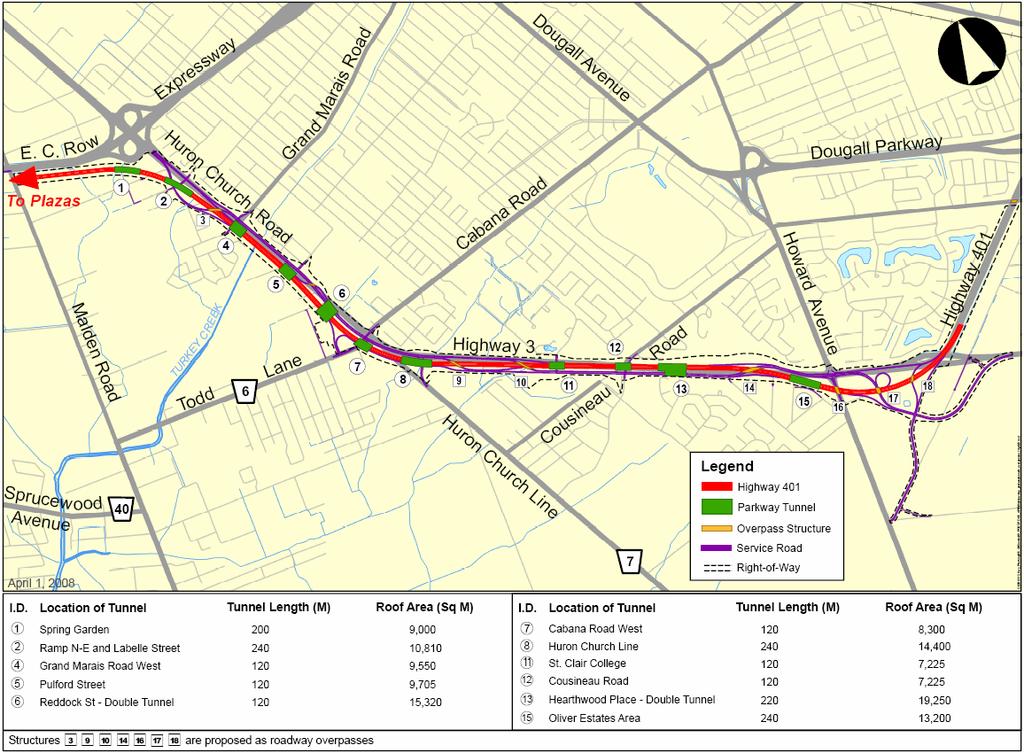
12 Following the last round of PIOHs in August of 2007, the Parkway was refined to include: Additional Tunnel in vicinity of Spring Garden Location and Length of Tunnel at Oliver Estates revised Overall length of tunnels increased to 1.86 km Other Tunnel lengths and locations refined Pedestrian and Cyclists Trails refined New Loop ramp at Todd Lane (EW-S) Howard Avenue Interchange modified to include connection to possible future Laurier Parkway Extension 12
13 13
14 Access Road Assessment Changes in Air Quality All alternatives provide a net benefit to local air quality by reducing tailpipe emissions and reducing traffic diversion to city streets No substantive difference in changes in air quality among all alternatives considered End-to-end tunnel with ventilation buildings can result in minor reductions in particulate concentrations within 50m of right-of-way when compared to other alternatives The Windsor-Essex Parkway has similar benefits to air quality as other alternatives 14
15 Access Road Assessment Protect Community & Neighbourhood Characteristics All Alternatives: Reduce international traffic on local streets Have no predicted noise impacts Have impacts in the Spring Garden Road / Malden Road area Have similar effect to neighbourhoods/businesses/social features Affect the same neighbourhoods to varying degrees Plaza A connection has greater impacts than Plaza B/C connections Below-grade alternatives provide aesthetic benefits 15

16 Access Road Assessment Protect Community & Neighbourhood Characteristics The Windsor-Essex Parkway provides greater buffer between neighbourhoods and roadway and as such requires more property New tunnel connections reduce the barrier effect of the roadway New recreational and greenspace areas are possible along the corridor Buffering effect reduces exposure of residences adjacent to roadway * preferred 16
17 Access Road Assessment Maintain Consistency with Existing & Planned Land Use Windsor-Essex Parkway design enables buffer areas and landscaping Recreational uses can be developed with the Windsor-Essex Parkway, consistent with Windsor and LaSalle planning policies promoting active and healthy communities The Windsor-Essex Parkway is consistent with Provincial Planning Policies Plaza A connection has greater impacts than Plaza B/C connection * preferred 17
18 Access Road Assessment Protect Cultural Resources No difference among alternatives in terms of built heritage and archaeological features impacted Windsor-Essex Parkway provides greater opportunities for new parks/recreation areas linked to existing parks/trails * preferred 18
19 Protect the Natural Environment Access Road Assessment No significant difference among alternatives The Windsor-Essex Parkway provides greater opportunities for restoration, enhancement and ecological connections Plaza A connection has greater impacts than Plaza B/C connection 19
20 Access Road Assessment Improve Regional Mobility All alternatives provide a high benefit to regional mobility Add capacity Separate international and local traffic Get trucks off local streets The Windsor-Essex Parkway provides Better access between freeway and service road Better service road operation * preferred 20
21 Cost and Constructability Access Road Assessment The Windsor-Essex Parkway alternative ($1.6 billion) has higher construction cost than other below-grade alternatives Cost estimates ($CDN for year 2011, Highway 401 to Malden Road) At-grade alternatives: $620 million to $920 million Below-grade alternatives: $1.0 billion to $1.4 billion Tunnel alternatives: $3.6 billion to 3.8 billion Windsor-Essex Parkway cost much higher than at-grade alternatives but much less than end-to-end tunnel 21
22 Summary of Assessment Access Road Assessment Factor Air Quality Community & Neighbourhood Land Use Cultural Resources Natural Environment Regional Mobility Cost & Constructability Preferred Alternative No Clear Preference Windsor-Essex Parkway Windsor-Essex Parkway Windsor-Essex Parkway No Clear Preference Windsor-Essex Parkway At-grade Overall: Advantages of Windsor-Essex Parkway outweigh higher costs and constructability concerns associated with this alternative * preferred 22
23 GreenLink GreenLink Concept presented by the City of Windsor as input to The Parkway DRIC study team reviewed materials provided by Windsor Same basic alignment as the Windsor-Essex Parkway but includes greater emphasis on tunnelling Provides access to local road network at similar locations Many features of GreenLink have been incorporated in the Windsor-Essex Parkway and are reflected in the analysis 23
24 Understanding GreenLink Knowledge of GreenLink helped DRIC team to develop Parkway Parkway developed from DRIC Practical Alternatives Alternative 2B (below-grade freeway) Alternative 3 end-to-end tunnel option GreenLink DRIC Team analyzed end-to-end tunnel and found that tunnels offer little improvement in air quality Tunnels in GreenLink would not provide substantial improvement in air quality, in comparison to Parkway 24
25 GreenLink Similarities There are many similarities between GreenLink and The Windsor-Essex Parkway: Both Plans Feature a six lane below-grade freeway with separate service roads for local traffic Provide tunnelled sections in key locations Include continuous trails that succeed in linking communities Have nearly identical property requirements with buffer areas between the roadway and the adjacent community Provide hundreds of acres of greenspace Provide an opportunity to create a signature gateway welcoming travellers to Canada, Ontario and Windsor and Essex County. 25
26 There are also many differences between GreenLink and The Windsor-Essex Parkway GreenLink does not meet provincial standards including: Substandard shoulder widths Insufficient drainage system GreenLink Differences GreenLink cost estimate does not include all expenditures required including: Only accounts for road work from Highway 3 to EC Row Expressway Substandard shoulder widths Does not account for engineering and contract administration Cost does not include adjustments for inflation Adjusting Greenlink cost estimate for total length of project, and to 2011 dollars, total cost estimated increases to $2.3 and $2.5 billion. Costs Approximately $1 billion more than The Windsor-Essex Parkway, with no additional benefits 26
27 The Windsor-Essex Parkway includes: Six-lane below-grade freeway Four lane service road At least 240 acres of open space 11 tunnels Over 20 kms of new pedestrian and cyclists trails At Least 20 Interchange Ramps Windsor-Essex Parkway provides 12,000 new jobs 27
28 Next Steps Complete evaluation of plaza-crossing alternatives with U.S. Team Preferred end-to-end solution anticipated Spring 2008 Public Information Open Houses, Workshops Dates to be determined Additional refinements possible following consultation Complete Environmental Assessment Documentation Late Fall

29 29
30 DRIC Study Canadian Team Ministry of Transportation Windsor Border Initiatives Implementation Group 949 McDougall Street, Suite 200, Windsor Tel URS Canada Inc. DRIC Project Office 1010 University Avenue W, Suite 104 Windsor, Ontario Mr. Dave Wake Manager, Planning Tel Mr. Murray Thompson Project Manager Tel Mr. Roger Ward Senior Project Manager Tel Mr. Len Kozachuk Deputy Project Manager Tel Project Web Site: 30
The Border Transportation Partnership
 DETROIT RIVER INTERNATIONAL CROSSING STUDY Town of LaSalle June 10, 2008 The Border Transportation Partnership 2 1 Purpose of the DRIC Study To provide for the safe, efficient and secure movement of people
DETROIT RIVER INTERNATIONAL CROSSING STUDY. Walpole Island First Nations Meeting December 13, 2007
 DETROIT RIVER INTERNATIONAL CROSSING STUDY Walpole Island First Nations Meeting December 13, 2007 Agenda Study Status Results from August 2007 Public Information Open House Overview of the Parkway Alternative
Presentation Overview
 DETROIT RIVER INTERNATIONAL CROSSING STUDY Presentation to Windsor Rotary Club October 23, 2006 1 Presentation Overview 1. Overview 2. Progress Update Technical Work Program Environmental Work Program
Study Process / Planning Policy Issues
 Memorandum Date: March 13 th, 2009 To: From: Reference: Subject: Murray Thompson, URS Canada Tyler Drygas, Senior Environmental Planner, URS Canada Detroit River International Crossing Study Response to
DETROIT RIVER INTERNATIONAL CROSSING. Detroit River. Conceptual Engineering Report VOLUME 1: SECTIONS 1 THROUGH 6. February 2008.
 Detroit River INTERNATIONAL CROSSING A B O R D E R T R A N S P O R TAT I O N PA R T N E R S H I P P R O J E C T DETROIT RIVER INTERNATIONAL CROSSING VOLUME 1: SECTIONS 1 THROUGH 6 February 2008 Prepared
The Ambassador Bridge/ Gateway Project
 The Ambassador Bridge/ Gateway Project Connecting Neighbors & Driving the Economy 2008 Ohio Conference on Freight Given by the Toledo Metropolitan Area Council of Governments, National Association of Regional
The Illinois Department of Transportation and Lake County Division of Transportation. Route 173, including the Millburn Bypass
 The Illinois Department of Transportation and Lake County Division of Transportation welcome you to this Public Hearing for U.S. Route 45 from Illinois Route 132 to Illinois Route 173, including the Millburn
WELCOME CPT CORRIDOR AREA PROJECT BACKGROUND BROOKSIDE BLVD. The objectives of the CPT Functional Design Study included:
 1 WELCOME Welcome to the Public Information Session for the Functional Design Study of the Chief Peguis Trail Extension West from Main Street to Brookside Boulevard PROJECT BACKGROUND The objectives of
Southern Gateway Project and Public Green
 Southern Gateway Project and Public Green Transportation and Trinity River Project Committee May 23, 2016 Purpose of Presentation Provide the history and an overview of the Southern Gateway Project (SGP)
Second Line West Pedestrian/Cyclist Crossing of Highway 401 Class EA. Second Line West Pedestrian/Cyclist Crossing of Highway 401 Class EA
 1 1 Purpose of Public Information Centre #2 To provide interested and/or potentially affected stakeholders with an opportunity to participate in the planning and decision-making process for this Municipal
We d like to thank you for attending this Wekiva Parkway Section 8 Preliminary Design Update hosted by the Florida Department of Transportation.
 We d like to thank you for attending this Wekiva Parkway Section 8 Preliminary Design Update hosted by the Florida Department of Transportation. We will provide you information on the overall project and
Welcome. Green Line LRT. Beltline Alignment Options. Stay engaged! Follow the Green Line story at calgary.ca/greenline
 Welcome Green Line LRT Beltline Alignment Options Stay engaged! Follow the Green Line story at calgary.ca/greenline Green Line LRT Why are we here? Our Challenge Determine the best alignment in the Beltline.
PREPARED FOR: PLATTEVIEW ROAD CORRIDOR STUDY EXECUTIVE SUMMARY
 PREPARED FOR: PLATTEVIEW ROAD CORRIDOR STUDY EXECUTIVE SUMMARY SEPTEMBER 2016 Introduction The Platteview Road Corridor Study was led by the Metropolitan Area Planning Agency (MAPA) with assistance from
Public Information Centre #1
 and Highway 401 Interchange Improvements WELCOME Public Information Centre #1 Veterans Memorial Parkway Extension and Highway 401 Interchange Improvements Study May 23, 2012 4 p.m. to 7 p.m. Brief Overview
I-4 Beyond the Ultimate. Florida Transportation Builders Association February 9, 2018
 I-4 Beyond the Ultimate Florida Transportation Builders Association February 9, 2018 FDOT: Improving Mobility & Safety in Central Florida FDOT is Designing and building a better I-4 through Central Florida
Mavis Road Class Environmental Assessment
 Mavis Road Class Environmental Assessment Public Information Centre #2 Wednesday November 9, 2016 6:00 to 8:00 p.m. Please sign in and complete a comment sheet Review the displays on your own or join in
Alternatives Development Three conceptual alternatives were developed for the Race Road/Jessup Village Planning Study and are described below:
 Race Road/Jessup Village Planning Study (H550601) Project Newsletter Spring 2015 Project Description The Study Team, consisting of staff from Anne Arundel County (Department of Public Works and Department
APPENDIX K WINDSOR OFFICIAL PLAN
 CEAA ENVIRONMENTAL ENVIRONMENTAL IMPACT ASSESSMENT AMBASSADOR BRIDGE ENHANCEMENT PROJECT Replacement Span and Plaza Expansion APPENDIX K WINDSOR OFFICIAL PLAN Avalon Consulting Professionals of Ontario,
2007 TAC SUSTAINABLE URBAN TRANSPORTATION AWARD SUBMISSION. Bridge Over Highway 401 for Pedestrians and Cyclists in Waterloo Region
 2007 TAC SUSTAINABLE URBAN TRANSPORTATION AWARD SUBMISSION Bridge Over Highway 401 for Pedestrians and Cyclists in Waterloo Region Project Partners: City of Cambridge City of Kitchener Region of Waterloo
3 CONSULTATION. 3.1 Consultation Overview
 3 CONSULTATION 3.1 Consultation Overview From the outset of the study, the study team realized that the Detroit River International Crossing project would have benefits and impacts on many stakeholders
Former Rockcliffe Airbase Community Design Plan Guiding Design Vision and Principles December 4, 2013
 APPENDIX 5 - Guiding Design Vision and Principles Former Rockcliffe Airbase Community Design Plan Guiding Design Vision and Principles December 4, 2013 Vision Statement The redevelopment of the former
Red Hill Valley Project More Than A Road October 16, 2006
 Red Hill Valley Project Presented By: More Than A Road October 16, 2006 September, 2007 Gerry Davis, C.M.A., Senior Director, Capital Planning and Implementation Division Public Works Department City of
Corridor Enhancements
 Corridor Enhancements Safety is MoDOT s first priority in widening and rebuilding I-70 across the state of Missouri. MoDOT also understands that the interstate - and its interchanges and overpasses - are
University of Saskatchewan CAMPUS MASTER PLAN. Senate Meeting Preliminary Presentation. April 21, 2018 DIALOG ECS DA WATT
 University of Saskatchewan CAMPUS MASTER PLAN Senate Meeting Preliminary Presentation April 21, 2018 DIALOG ECS DA WATT project process presentation agenda Stakeholder Engagement Project Control phase1
Mississippi Skyway Preliminary Engineering Report
 EXECUTIVE SUMMARY Mississippi Skyway Preliminary Engineering Report CITY OF RAMSEY, MINNESOTA DECEMBER 2014 City of RAMSEY EXECUTIVE SUMMARY Project Need and Intent The Mississippi Skyway pedestrian bridge
WELCOME TO OPEN HOUSE TWO November 28, 2018
 Langstaff Road Weston Road to Highway 7 Class Environmental Assessment Study WELCOME TO OPEN HOUSE TWO November 28, 2018 Please sign in and join our mailing list Study Overview York Region is conducting
THE CORPORATION OF THE CITY OF WINDSOR Office of the City Solicitor Planning Department
 THE CORPORATION OF THE CITY OF WINDSOR Office of the City Solicitor Planning Department REPORT TO THE CITY OF WINDSOR PLANNING ADVISORY COMMITTEE DATE OF REPORT: August 19, 2010 SUBJECT: Official Plan
SQUAMISH 2010 AND BEYOND COMMUNITY VISION
 Our plan has been imagined and created to be both pragmatic and visionary. At the core of the strategy is a consideration of the highway s role and its impact on the community. First and foremost in creating
Welcome to the. Open House
 Welcome to the 5th Street to Kinsman Road Open House November 14 5:30 7:00 p.m. Please sign in Project Overview In December 2016, City Council adopted SW 5th Street as the preferred alignment to connect
Gratigny Parkway East Extension Project Development & Environment (PD&E) Study
 Study") Gratigny Parkway East Extension Project Development & Environment (PD&E) Study Session 4: Presentation of Charrette Results December 8, 2010 MDX Work Program #: 92407 ETDM#: 11500 Project Location & Description
Gratigny Parkway East Extension Project Development & Environment (PD&E) Study Session 4: Presentation of Charrette Results December 8, 2010 MDX Work Program #: 92407 ETDM#: 11500 Project Location & Description
Subject: City of Richfield Cedar Avenue Corridor Plan Comprehensive Plan Amendment, Review File No
 Committee Report Business Item No. 2017-21 Community Development Committee For the Metropolitan Council meeting of January 25, 2017 Subject: City of Richfield Cedar Avenue Corridor Plan Comprehensive Plan
5. Spring Garden Planning Area (Secondary Plan added by OPA #05 11/29/2002)
") 5. Spring Garden Planning Area (Secondary Plan added by OPA #05 11/29/2002) 5.0 Preamble THE PLANNING AREA FRAGMENTED OWNERSHIP PATTERN EMERGING LAND USE ISSUES IMPLEMENT STUDY FINDINGS The Spring Garden
5. Spring Garden Planning Area (Secondary Plan added by OPA #05 11/29/2002) 5.0 Preamble THE PLANNING AREA FRAGMENTED OWNERSHIP PATTERN EMERGING LAND USE ISSUES IMPLEMENT STUDY FINDINGS The Spring Garden
SH 199 Corridor Master Plan. Community Meeting No. 2 May 31, 2017
 Community Meeting No. 2 May 31, 2017 Transportation Projects On or Near SH 199 SH 199 from 0.3 miles south of FM 1886 to south end of Lake Worth bridge Construct freeway mainlanes and frontage roads 10-Year
I. DESCRIPTION OF PROPOSED ACTION... 1 A. General Description... 1 B. Historical Resume and Project Status... 2 C. Cost Estimates...
 PROJECT COMMITMENTS SUMMARY... S-1 1. Type of Action... S-1 2. Description of Action... S-1 3. Summary of Purpose and Need... S-1 4. Alternatives Considered... S-2 5. NCDOT Alternatives Carried Forward...
Red Fox Commercial Outline Plan
 Red Fox Commercial Outline Plan City of Cold Lake, Alberta Prepared by Durrance Projects Ltd and Ross W. Sharp & Associates Ltd October 2014 Rupert 1 Table of Contents 1. PURPOSE...3 1.1. Location...4
Commissioners Road West Realignment Environmental Assessment
 City of London Commissioners Road West Realignment Environmental Assessment Public Information Centre No. 1 March 30, 2017 Welcome to the Public Information Centre This first Public Information Centre
Services Department B September 10, 2007
 Report To: Development Services Committee Item: Date of Report: DS-07-246 September 5, 2007 From: Commissioner, Development File: Date of Meeting: Services Department B7200-0001 September 10, 2007 Subject:
20 & 30 Frank Nighbor Place
 Engineering Land / Site Development Municipal Infrastructure Environmental / Water Resources Traffic / Transportation Structural Recreational Planning Land / Site Development Planning Application Management
Welcome. Community Consultation Meeting November 28, Review and discuss the Bathurst Quay Neighbourhood Plan Framework
 Welcome Community Consultation Meeting November 28, 2016 Why Are We Here Today? Review and discuss the Bathurst Quay Neighbourhood Plan Framework Review and discuss an Action Plan for Implementation Next
Brampton. Secondary Plan. Review. Bram West. A New Direction in Planning & Public Consultation
 Brampton Bram West Secondary Plan Review A New Direction in Planning & Public Consultation Introduction The Bram West Secondary Plan Review offers an important opportunity for the community to define a
This Review Is Divided Into Two Phases:
 Semiahmoo Town Centre Review The purpose of this review: To review the Semiahmoo Town Centre Concept Plan, originally approved in 1993, to ensure that this centre will continue to serve the needs of South
East Corridor Final Environmental Impact Statement
 East Corridor Final Environmental Impact Statement Alternatives Considered Operating Plan The requirements for opening day operations versus year 2030 are based on ridership and operations. Opening day
GLEN ROAD PEDESTRIAN BRIDGE ENVIRONMENTAL ASSESSMENT STUDY PUBLIC INFORMATION CENTRE #2 OCTOBER 24, 2017
 GLEN ROAD PEDESTRIAN BRIDGE ENVIRONMENTAL ASSESSMENT STUDY PUBLIC INFORMATION CENTRE #2 OCTOBER 24, 2017 Glen Road Pedestrian Bridge Class Environmental Assessment 1 WELCOME! Welcome to the second Public
Wasatch CHOICE for 2040
 Wasatch CHOICE for 2040 Economic Opportunities We Can Choose a Better Future We enjoy an unparalleled quality of life along the Wasatch Front. People from all over the world are drawn to our stunning scenery,
NORTH-SOUTH CORRIDOR STUDY EXECUTIVE SUMMARY. Executive Summary
 Executive Summary Background As congestion continues to affect mobility in the region, the Ozarks Transportation Organization (OTO) is particularly concerned with traffic movement. The North-South Corridor
ITEM #8. Regional Smart Growth Program. Regional Smart Growth Program. Presentation Overview. Coast Highway Vision and Stategic Plan.
 Regional Smart Growth Program Economic Development Commission What is Smart Growth? Adopted as part of the Regional Comprehensive Plan (RCP) RCP provides vision for region based on Smart Growth and sustainability
South Davis County COMMUNITY SPOTLIGHT
 South Davis County COMMUNITY SPOTLIGHT Davis/SLC Community Connector Bus Rapid Transit line connecting SLC & Davis County RTP Phase 1 Project Generate 3,100 average weekday riders Relieve congestion on
Bostwick Road. Municipal Class Environmental Assessment. October 13, City of London. Bostwick Road Municipal Class Environmental Assessment
 Bostwick Road Municipal Class Environmental Assessment October 13, 2016 Welcome! Welcome to the first Public Information Centre for the Bostwick Road Municipal Class Environmental Assessment. Representatives
GTA West Corridor Planning and Environmental Assessment Study Public Information Centre #5 ADDITIONAL ANALYSIS IN THE HALTON AREA Backgrounder
 GTA West Corridor Planning and Environmental Assessment Study Public Information Centre #5 ADDITIONAL ANALYSIS IN THE HALTON AREA Backgrounder Focus of Public Information Centre (PIC) #5: Present key findings
Potential Green Infrastructure Strategies May 6, 2015 Workshop
 Potential Green Infrastructure Strategies May 6, 2015 Workshop Background The City of Cortland is developing the Tioughnioga Urban Headwaters Green Infrastructure Action Plan with funding from the National
Workshop 3. City of Burlington Waterfront Hotel Planning Study. September 14, The Planning Partnership
 Workshop 3 City of Burlington Waterfront Hotel Planning Study September 14, 2017 The Planning Partnership The Waterfront Hotel Planning Study 01 The Brant & Lakeshore Planning Study will establish a Strategic
TRANSPORTATION COMMITTEE
 TRANSPORTATION COMMITTEE CITY OF OTTAWA Ministry of Transportation Detailed Design Assignment G.W.P.# 4058-01-00 Highway 417 (Ottawa Queensway) Widening & Rehabilitation from Maitland Avenue to Island
Technical Memorandum 5
 Technical Memorandum 5 Environmental Resources August 2015 PREPARED BY AECOM Table of Contents Introduction... 3 Natural Features... 6 Watersheds... 6 Rivers, Lakes, Creeks... 6 Wetlands... 8 Floodplains...
Preliminary Plan Framework: Vision and Goals
 Preliminary Plan Framework: Vision and Goals Draft: May 2015 Introduction Since the Town of Milliken s comprehensive plan was last updated in 2010, the community was heavily impacted by the 2013 flood,
MAYFIELD WEST SECONDARY PLAN PHASE 2
 MAYFIELD WEST SECONDARY PLAN PHASE 2 Public Open House #3 February 25, 2010 Draft Preferred Land Use Scenario TOWN OF CALEDON PLANNING & DEVELOPMENT DEPARTMENT Open House Agenda TOWN OF CALEDON 1. Welcome
Rt. 29 Solutions Project Delivery Advisory Panel. January 7, 2016
 Rt. 29 Solutions Project Delivery Advisory Panel January 7, 2016 Agenda item 1: Introductions Project Delivery Advisory Panel Technical Team 2 Agenda item 2: Interaction and Feedback Live Streaming Dec
Evaluation Criteria. Detailed Evaluation Criteria
 Evaluation Criteria Detailed Evaluation Criteria Community Well-being A safe and socially inclusive service that improves access to key community destinations and provides transportation choices for Calgarians.
CENTRAL BEDFORDSHIRE COMMITTED TO WORKING TOGETHER WITH LOCAL COMMUNITIES
 WELCOME Thank you for coming to our consultation event to find out more about our emerging proposals for Hayfield Park, a residential development jointly promoted by the Hayfield Consortium: Martin Grant
Don Mills Crossing Study and Celestica Lands Development Application Community Meeting, Open House, and Breakout Discussions
 Consultation Summary Don Mills Crossing Study and Celestica Lands Development Application Community Meeting, Open House, and Breakout Discussions This report is not intended to provide a verbatim transcript
July 12, Columbus City Council City Hall 90 West Broad Street Columbus, OH RE: I-70/71 Columbus Crossroads Project
 OHIO DEPARTMENT OF TRANSPORTATION DISTRICT 6 400 EAST WILLIAM STREET DELAWARE, OHIO 43015 800.372.7714 Columbus City Council City Hall 90 West Broad Street Columbus, OH 43215-9015 RE: I-70/71 Columbus
WELCOME! 8 8:30 6: TH STREET IMPROVEMENTS. Open House. Presentation & Q&A
 WELCOME! 168 TH STREET IMPROVEMENTS 6:30 Open House 7 8 Presentation & Q&A 8 8:30 Open House WELCOME Todd Pfitzer City of Omaha Engineer Bob Stubbe City of Omaha Public Works Director Jon Meyer Project
12 AMENDMENT NO. 149, TOWN OF MARKHAM HIGHWAY 404 NORTH SECONDARY PLAN
 12 AMENDMENT NO. 149, TOWN OF MARKHAM HIGHWAY 404 NORTH SECONDARY PLAN The Planning and Economic Development Committee recommends the adoption of the recommendation contained in the following report August
4/8/2015 Item #10D Page 1
 MEETING DATE: April 8, 2015 PREPARED BY: Christy Villa, Associate Civil Engineer DEPT. DIRECTOR: Glenn Pruim DEPARTMENT: Public Works CITY MANAGER: Larry Watt SUBJECT: NORTH COAST HIGHWAY 101 STREETSCAPE
St. Clair Avenue West Area Transportation Master Plan
 1 (Between Keele Street and Old Weston Road) Public Information Centre 1 December 2, 2015 2 Welcome Welcome to the first Public Information Centre for the St. Clair Avenue West Area. The panels will present
SUMMARY. Support the Southeast Arkansas Regional Intermodal Facility.
 SUMMARY THE I-69 LOCATION STUDY The proposed I-69 Location Study from El Dorado to McGehee, Arkansas, represents one section (Section of Independent Utility No. 13) of the nationally designated I-69 Corridor
Clair-Maltby Community visioning
 Clair-Maltby Community visioning workshop #1 Summary April 27th, 2017 Table of Contents INTRODUCTIon 1 PURPOSE 1 CONSULTATION STRUCTURE 2 PARTICIPANT FEEDBACK 3 VISIONING EXERCISE 8 ONLINE SURVEY RESULTS
2.0 PURPOSE AND NEED. 2.1 Purpose. 2.2 Need Traffic Congestion in and around Downtown Derry
 2.0 PURPOSE AND NEED Taking into consideration agency and public input, the purpose and need for the Project was identified early in Project planning. As noted in Appendix A, for purposes of meeting the
Northeast Anthony Henday Drive Manning Freeway to Whitemud Drive Welcome to this Construction Information Session
 Manning Freeway to Whitemud Drive Welcome to this Construction Information Session Purpose To inform interested residents and businesses about the plans accommodation. Background: The Government of Alberta
Official Plan Review
 Official Plan Review Summary Report - The Built Environment August 2014 Part 1: Introduction Planning for a healthy, prosperous and sustainable community is an important goal for our municipality. From
Complete Streets Guidelines & Implementation Strategy. Public Open House #2 June 12, :30-8:00 pm
 Complete Streets Guidelines & Implementation Strategy Public Open House #2 June 12, 2018 5:30-8:00 pm Purpose The purpose of this project is to develop Complete Streets guidelines and an implementation
Section4 Design Vision & Implementation Plan
 Section4 Design Vision & Implementation Plan W Woodschurch Rd 4.1 Design Focus Areas The Framework Plan is simply the starting point for directing the design and implementation of a wide range of transportation
MAYFIELD WEST SECONDARY PLAN PHASE 2
 MAYFIELD WEST SECONDARY PLAN PHASE 2 Council Information Workshop February 16, 2010 Draft Preferred Land Use Plan TOWN OF CALEDON PLANNING & DEVELOPMENT DEPARTMENT Workshop Agenda TOWN OF CALEDON 1. Welcome
Smart Growth Development Checklist
 2004 Smart Growth Development Checklist Smart Growth Development Checklist Corporation of the City of New Westminster Guide and manage growth in a manner which is consistent with the principles of sustainable
Bloor Street East Potential Ravine Portal Overlook and Access Passage to the Rosedale Valley and Don River Valley Ravine, Toronto, Canada
 TRANSFORMATIVE IDEA 2. GREAT STREETS Bloor Street Christie Pits Park Bloor St Spadina Ave Bathurst St Shaw St 1 Recognize the significant public realm improvements along Bloor Street and extend and enhance
2900 Steeles Avenue East at Don Mills Road in the Town of Markham
 STAFF REPORT INFORMATION ONLY 2900 Steeles Avenue East at Don Mills Road in the Town of Markham Date: January 23, 2008 To: From: Wards: Reference Number: North York Community Council Director, Community
TOWN OF CALEDON Land Use Study for GTA West Corridor and Adjacent Lands!
 TOWN OF CALEDON Land Use Study for GTA West Corridor and Adjacent Lands! Presentation to Council! March 10, 2015! Why are we here?! 1. The Province has now developed a short list of possible routes for
II PREVIOUS REPORTS PERTINENT TO THIS MATTER II
 ~ ~~ ~~~ ~ ~~ ~ ~~~~ ~ ~~ ~~ ~~~~ ~ Agenda Item # Page # TO: FROM: -..-.-I- 3UBJCL I CHAIR AND MEMBERS ENVIRONMENT AND TRANSPORTATION COMMITTEE MEETING ON OCTOBER 17,2005 DAVID A. LECKIE, P. ENG DIRECTOR
The purpose of tonight s PIC is to:
 The purpose of tonight s PIC is to: Provide an overview of the work completed to date and a summary of the Class EA process being followed; Provide a summary of public input received so far, including
TORONTO COMPLETE STREETS GUIDELINES
 TORONTO COMPLETE STREETS GUIDELINES Presentation by Fiona Chapman, Manager, Pedestrian Projects Public Realm Section, Transportation Services, City of Toronto June 2017 PURPOSE OF THE PROJECT To develop
ARGENTA TRAIL (CSAH 28/63) REALIGNMENT SOUTH PROJECT (CP 63-25)
 REALIGNMENT SOUTH PROJECT (CP 63-25)") ARGENTA TRAIL (CSAH 28/63) REALIGNMENT SOUTH PROJECT (CP 63-25) Preliminary Design Report February 2015 Prepared For: City of Inver Grove Heights Dakota County Prepared By: Kimley-Horn and Associates,
ARGENTA TRAIL (CSAH 28/63) REALIGNMENT SOUTH PROJECT (CP 63-25) Preliminary Design Report February 2015 Prepared For: City of Inver Grove Heights Dakota County Prepared By: Kimley-Horn and Associates,
I-70 Corridor Enhancement Plan
 i - Table of Contents Table of Contents Chapter I Overview Chapter II Bridge and Roadway Improvements Chapter III Landscape Enhancements Chapter IV Riparian Corridors Chapter V Showcase Missouri Plan Chapter
Commissioners Road West Realignment Environmental Assessment
 City of London Commissioners Road West Realignment Environmental Assessment Public Information Centre No. 2 November 29, 2017 Welcome to the Public Information Centre This 2 nd Public Information Centre
Princess Anne Road. Phase VII (CIP 2-195) Citizens Information Meeting
 Citizens Information Meeting") Citizens Information Meeting Princess Anne Road Phase VII (CIP 2-195) Wednesday, May 5, 2004 4:30 PM to 7:00 PM Red Mill Elementary School 1860 Sandbridge Road Virginia Beach, VA Welcome to the Citizens
Citizens Information Meeting Princess Anne Road Phase VII (CIP 2-195) Wednesday, May 5, 2004 4:30 PM to 7:00 PM Red Mill Elementary School 1860 Sandbridge Road Virginia Beach, VA Welcome to the Citizens
Public Meeting #3 May 9, 2009 MVVA Team
 Public Meeting #3 May 9, 2009 MVVA Team Welcome to the third Public Meeting for the Lower Don Lands Municipal Class Environmental Assessment (EA) Infrastructure Master Plan and Keating Channel Precinct
Relief Line Project Assessment
 Relief Line Project Assessment Public Information Centre April 5, 2017 Tonight s Meeting PURPOSE To review the preferred alignment for the Local Segment. AGENDA 6:30 Open House 7:00 Presentation / Discussion
Purpose of Open House #3
 Public Meeting #3 May 9, 2009 MVVA Team Purpose of Open House #3 The main purpose of this Open House is to present and seek input on the: Evaluation of transportation and infrastructure design alternatives
Bridge Type Assessment and Evaluation
 16M-01410-01 (3216026) Glen Road Pedestrian Bridge EA Study Bridge Type Assessment and Evaluation Factor Group/Criteria Alternative 1: Steel girder with two inclined steel legs Alternative 2: Steel girder
HURON COMMUNITY PLAN
 CITY OF KITCHENER DEPARTMENT OF DEVELOPMENT AND TECHNICAL SERVICES PD 94/7 HURON COMMUNITY PLAN Recommended by Planning and Economic Development Committee: October 31, 1994 Adopted by Kitchener City Council:
Shift Rapid Transit Public Participation Meeting May 3, 2017
 Shift Rapid Transit Public Participation Meeting May 3, 2017 Shift Rapid Transit Initiative Largest infrastructure project in the city s history. Rapid Transit initiative will transform London s public
Subarea 5 Southern Gateway. Vision. Mobility The proposed street network will create developable blocks that are scaled appropriately for the area.
 southern gateway 194 Southern Gateway extends south of I-435 to 123 rd Street and includes the area past the Blue Valley Parkway division. This area is adjacent to major office centers such as the College
STUDY AREA LOCATION & CONTEXT:
 UNLOCKING THE POTENTIAL OF THE KEATING CROSS ROAD BUSINESS CORRIDOR A PLAN TO CREATE + RETAIN JOB-GENERATING BUSINESSES AND TO GUIDE INFRASTRUCTURE INVESTMENT The Keating Cross Road Corridor (the Keating
University Parkway Corridor Plan. Public Workshop Sept. 18, 2017
 University Parkway Corridor Plan Public Workshop Sept. 18, 2017 AGENDA 1. Overview of Process 2. Study Area 3. Components of the Plan 4. What We Know 5. What We Have Heard 6. Tonight s Input 7. Next Steps
Corridors. Re-vitalize our Corridors and Gateways
 Corridors Re-vitalize our Corridors and Gateways Artist s rendering from the 287 Strategic Plan, 2015 Corridors are the major throughways of Loveland but they also provide important commercial, community
Background Summary Report
 Background Summary Report May 2014 Submitted by Macaulay Shiomi Howson Ltd. In association with AMEC MMM Group Brook McIlroy Inc. Hemson Consulting Ltd. Table of Contents 1. Introduction... 1 2. Why is
West Gate Tunnel panel hearing
 Source: Western Distributor Authority Alison Whitten Master in Urban Planning Bachelor of Science in Systems Engineering James Whitten Master of Architecture in Urban Design Bachelor of Architecture Bachelor
CATARAQUI RIVER THIRD CROSSING EA Landscape Analysis Background Report. October 23, Corush Sunderland Wright Limited
 October 23, 2009 Corush Sunderland Wright Limited INTRODUCTION The City of Kingston has initiated an Environmental Assessment (EA) to assess the need for, and the feasibility of, implementing additional
SPECIFIC PLAN Requirements
 CITY OF LANCASTER PLANNING DEPARTMENT 44933 Fern Avenue, Lancaster, California 93534 (661) 723-6100 SPECIFIC PLAN Requirements Purpose The purpose of a specific plan is to provide for the logical development
PROPOSED IMPROVEMENTS
 IV. PROPOSED IMPROVEMENTS The proposed improvements for each alternative carried forward are discussed below. A. FUNCTIONAL CLASSIFICATION AND ROADWAY CROSS-SECTIONS The classifications of the roadways
2.5 Roads. Loading and service areas adjacent to Highway 401 should be screened through architectural walls and/or landscape buffer planting.
 N HIGHWAY OFF RAMP 2.5 Roads A legible road network with a clear hierarchy will help create a connected community, both within and surrounding the Milton Heights. The following section outlines the proposed
CITY COUNCIL AGENDA REPORT
 CITY COUNCIL AGENDA REPORT Subject: COUNCIL MOTION LRT ALIGNMENT REMOVAL FROM THE TRANSPORTATION MASTER PLAN On February 10, 2016 Councillor Hughes provided notice in accordance with Section 23 of Procedure