2017 General Obligation Bond
|
|
|
- Ambrose Hunt
- 5 years ago
- Views:
Transcription
1 2017 General Obligation Bond Presentation of Public and Council Projects to the Transportation & Mobility Stakeholder Committee April 13, 2017
2 Agenda Deferred Maintenance Project Development Process Projects Submitted from Public Process Question/Answer 2

3 Deferred Maintenance Need 3

4 4
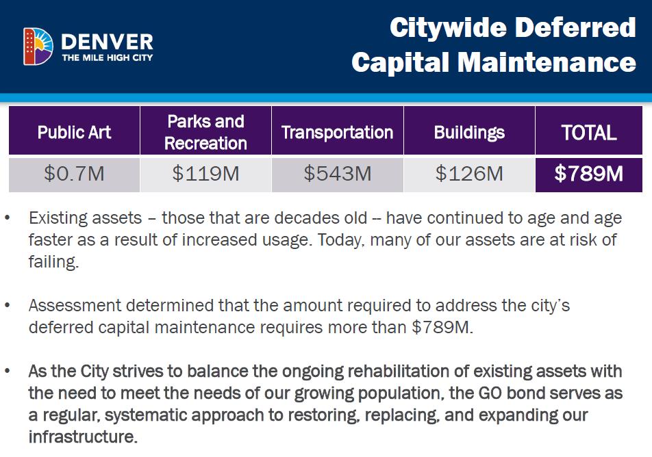
5 5


 Signal Warrants 2) Operational")
6 Project Development Process Neighborhood Planning Transportation Network Planning Corridor Plan/ Concept Idea 30% Conceptual Design 60% Final Design 100% Design/ Construction Network level Identify needs Limited design detail No cost or prioritization Network level Defines project type Includes planning level cost estimate Establishes prioritization Project-specific Cross-section Includes alternatives analysis Determines what will be designed Refines planning level cost estimate Identify risks Layout design Finalize alignments Survey Drainage analysis Environmental study Right of way acquisitions Engineering cost estimate Utility conflicts Earthwork Horizontal and vertical controls Earthwork Standards and specifications Revised engineering cost estimate Final BID package Final cost estimate Advertise the project St. Lukes Area General Development Plan Denver Moves Bicycles 19 th /20 th Aves Two-way Conversion 1) Signal Warrants 2) Operational Analysis 3) Bike Alternatives Study 30% Design 60% Design Build months 9-12 months months 6-9 months 3-6 months 6-12 months
7 Projects From Public Process 22 additional projects identified by City Council and/or public during community engagement in November/December 2016 Cost estimates are at a planning level and not been verified by City engineers 7


8 Already in Development 23 rd Avenue Bridge (#5) CDOT bridge just completed $3m repair project, when meets criteria eligible reconstruction for CDOT Bridge funding, City has submitted new cross-section Blake Street Connections (#25) Two-way conversion from Broadway to Downing completed in 2016 High Line Canal Connections (#54) Identified in the High Line Canal connections study Parker/Mississippi, Colorado and Hampden underpasses received federal funding Underpass at Yale remains unfunded. 8
 Project Characteristics Additional lanes Medians Intersection Improvements Neighborhood Plan Transportation")
9 Corridor Projects 1 st Avenue Improvements (#3) 38 th Extension (#9) Alameda Parkway: Madison to Colorado (#20) Identified in the Cherry Creek Area Plan Hampden Corridor Multimodal Improvements (#52) Corridor study funded in 2017 that will identify improvements Tower Road Improvements (#82) Project Characteristics Additional lanes Medians Intersection Improvements Neighborhood Plan Transportation Network Planning Concept Idea 30% Concept Design 60% Final Design Construction 9
10 Streetscape Projects East Colfax Upgrades Remaining improvements from the East Montclair/East Colfax Neighborhood Plan Morrison Road Improvements (#59) Proposal by BuCu West Santa Fe Corridor Improvements (#73) Proposal by Santa Fe Drive BID Streetscape Improvements (#80) Proposal from Federal Boulevard BID Project Characteristics Sidewalk Widening Crossing Improvements Street Trees and Landscaping Lighting Benches Public Art Next Steps City-led design process Neighborhood Plan Transportation Network Planning Concept Idea 30% Concept Design 60% Final Design Construction 10
11 Station Area Connections Buchtel and Colorado Boulevard Intersection Improvements (#33) Colorado Station Bike/Pedestrian Access (#44) Southmoor Station Pedestrian Access (#78) Yale Station Pedestrian Safety (#90) Project Characteristics Improved crossings of major arterials Ped/Bike trail connections Next Steps Identification of crossing treatment City-led design process Neighborhood Plan Transportation Network Planning Concept Idea 30% Concept Design 60% Final Design Construction 11
12 Pedestrian Improvements Central Streets Improvements (#35) Citywide Crosswalk Improvements (#37) Green Valley Ranch Pedestrian Improvements (#50) Park Hill Pedestrian Improvements (#62) Pedestrian Safety Improvements (#64) Safe Routes to School (#70) Tennyson Street Pedestrian Improvements (#81) Project Characteristics General requests for intersections Next Steps Prioritization of locations Identification of needed improvement or crossing treatment City-led design process Neighborhood Plan Transportation Network Planning Concept Idea 30% Concept Design 60% Final Design Construction 12
13 Questions?
Public input has been an important part of the plan development process.
 Lakewood s Comprehensive Plan recognizes that transportation helps shape the community, and that the way the community provides for the safe and efficient movement of people affects the character of the
TAC/CAC, TPO Project Update February 2016
 A1A MULTIMODAL CORRIDOR PLANNING AND ENGINEERING ANALYSIS Florida Department of Transportation TAC/CAC, TPO Update February 2016 PRESENTATION FOOTERT Meeting Agenda What We Plan To Discuss Background New
SH 199 Corridor Master Plan. Community Meeting No. 2 May 31, 2017
 Community Meeting No. 2 May 31, 2017 Transportation Projects On or Near SH 199 SH 199 from 0.3 miles south of FM 1886 to south end of Lake Worth bridge Construct freeway mainlanes and frontage roads 10-Year
Por favor, levanten la mano si necesita traduccion en espanol Please raise your hand if you need Spanish translation
 FEDERAL BOULEVARD CORRIDOR WIDE STUDY PUBLIC MEETING #1 APRIL 27, 2016 Por favor, levanten la mano si necesita traduccion en espanol Please raise your hand if you need Spanish translation HDR DESIGN WORKSHOP
SCTPO Project Summary September 2014
 A1A MULTIMODAL CORRIDOR PLANNING AND ENGINEERING ANALYSIS Florida Department of Transportation SCTPO Project Summary September 2014 PRESENTATION FOOTER Meeting Agenda What We Plan To Do Project Background
WELCOME 4201 E. ARKANSAS AVENUE PROPERTY COMMUNITY DISCUSSION
 WELCOME 4201 E. ARKANSAS AVENUE PROPERTY COMMUNITY DISCUSSION Salem United Church of Christ June 7, 2018 AGENDA Introduction Existing Conditions CDOT s Next Steps Proposed Zoning Overview Transportation
The following principles guide the development of goals and strategies to protect and promote these amenities:
 OPEN SPACE/PARKS/TRAILS/RECREATION GOALS/STRATEGIES Cherry Hills Village is a living environment that offers low density development, open areas, public scenic vistas, public trails and public parks. This
West Dennis Center: Bass River to Old Main Street. West Dennis Business District: Old Main Street to Dennis Commons
 West Dennis Center: Bass River to Old Main Street West Dennis Business District: Old Main Street to Dennis Commons Dennisport Center: Dennis Commons to Division Street Main Street Project Goals Project
INTEGRATION PLAN. Harvard Gulch
 INTEGRATION PLAN Harvard Gulch August 31, 2016 Related Projects and Partners Tonight s Agenda 1. Welcome & Meeting Purpose 2. Other Project Updates Floodplain Study Urban Waterways Study 3. Purpose of
1.0 Introduction. Purpose and Basis for Updating the TMP. Introduction 1
 1.0 Introduction The Town of Castle Rock is situated between the metropolitan areas of Denver and Colorado Springs, amidst a unique terrain of rolling hills, mesas, ravines, and waterways. Like many Front
Executive Summary. NY 7 / NY 2 Corridor
 Executive Summary NY 7 / NY 2 Corridor Transportation and Land Use Study December 2005 Prepared for: Town of Colonie Capital District Transportation Committee Prepared by: Introduction: Land use decisions
2040 Long Range Transportation Plan
 2040 Long Range Transportation Plan Adopted: April 15, 2013 APPENDIX D HIGHWAY NEEDS PLAN PROJECTS FREDERICKSBURG Existing and Committed Projects Fall Hill Avenue/Mary Washington Blvd. (Fredericksburg)
CHAPTER 7: Transportation, Mobility and Circulation
 AGLE AREA COMMUNITY Plan CHAPTER 7 CHAPTER 7: Transportation, Mobility and Circulation Transportation, Mobility and Circulation The purpose of the Transportation, Mobility and Circulation Chapter is to
A larger version of this map is located on the last page of this PDF.
 MAP Committee Input McLoughlin Area Draft Vision Map A larger version of this map is located on the last page of this PDF. 1. The map above is intended to portray a vision for the McLoughlin area. It highlights
Pedestrian and Bike Bridge LOGO
 6.2.2 Pedestrian and Bike Bridge The proposed pedestrian and bike crossing re-envisions the existing bridge at Pismo Creek on Cypress Street. The bridge is currently underutilized by vehicular through
Welcome. Northern Segment of Hwy 100 I-90 to South of Madison Street Meeting Goals:
 Welcome Northern Segment of Hwy 100 I-90 to South of Madison Street Meeting Goals: - Review Environmental Assessment - Share Preferred Alternative -Receive Public Comments 2003 EA Preferred Alternative
Municipality of Anchorage. Community Council Survey Capital Projects Needs Ranking Survey (ALPHABETICAL) Airport Heights
 Airport Heights") ANCHORAGE PARKS & RECREATION Nichols Park Design and improve neighborhood park 2008 Challenge Grant applicant. 2008 $500K State Grant for Neighborhood Parks. Tikishla Park Lighting, paved parking, hockey
ANCHORAGE PARKS & RECREATION Nichols Park Design and improve neighborhood park 2008 Challenge Grant applicant. 2008 $500K State Grant for Neighborhood Parks. Tikishla Park Lighting, paved parking, hockey
CITY OF LAKEWOOD 2012 THREE-MILE PLAN
 CITY OF LAKEWOOD 2012 THREE-MILE PLAN SECTION 1: INTRODUCTION This document constitutes the s Three-Mile Plan for the unincorporated area three miles in width around the City s perimeter, as required by
Date: April 10, 2017 City Council Work Session April 24, 2017: Status Report on the Comprehensive Plan Update and Transportation Master Plan
 AGENDA REPORT To: From: By: Honorable Mayor and City Council Members Warren Hutmacher, City Manager Sharon Ebert, Director Community Development Date: April 10, 2017 Agenda: City Council Work Session April
Copyright, 2010 Hyperform Design Co-op, All Rights Reserved WEST COLFAX AVENUE GREEN PILOT: STREETSCAPE
 c Copyright, 2010 Hyperform Design Co-op, All Rights Reserved 2 Prepared for West Colfax Business Improvement District Prepared by Hyperform Design Co-op Hyperform Design Co-op 227 Broadway, Suite 205
Capital Projects in and near Odenton Town Center
 Capital Projects in and near Odenton Town Center Map ID Anne Arundel County Department of Public Works This project provides for the design, right of way acquisition, and construction of approximately
September 28, 2017 Wentworth Avenue (CR 8) Sidewalk Improvements Open House
 Sidewalk Improvements Open House") TIME Anytime from 5:00 PM to 7:00 PM LOCATION City Hall Council Chambers Learn about the project Speak with project representatives Provide input YOU RE INVITED! September 28, 2017 Wentworth Avenue (CR
TIME Anytime from 5:00 PM to 7:00 PM LOCATION City Hall Council Chambers Learn about the project Speak with project representatives Provide input YOU RE INVITED! September 28, 2017 Wentworth Avenue (CR
Capital Projects impacting Odenton Town Center
 Capital Projects impacting Odenton Town Center 1 2 E549700 W801600/ W801602 Anne Arundel County Department of Public Works Manor View Elementary School Transmission Main - MD 32 @ Meade Phase 2 $34,399,000
LITTLE ELM CAPTIAL IMPROVEMENT BOND STREET PRESENTATION
 LITTLE ELM 2009-2014 CAPTIAL IMPROVEMENT BOND STREET PRESENTATION Denton Frisco Little Elm Lewisville Legacy Southlake Grapevine Addison DENTON COUNTY & LEWISVILLE LAKE MATCHING FUNDS DENTON COUNTY BOND
BeltLine Corridor Environmental Study
 BeltLine Corridor Environmental Study Citywide Conversation on Transit and Trails April 2, 2009 Agenda & Introductions Introductions Environmental Study Process Overview of the BeltLine Project BeltLine
Memorandum CITY OF DALLAS. Riverfront Boulevard Design From Continental Avenue to Cadiz Street
 Memorandum DATE November 10, 2011 CITY OF DALLAS TO Trinity River Corridor Project Committee Members: Vonciel Jones Hill (Chair) Linda Koop (Vice Chair), Monica Alonzo, Scott Griggs, Angela Hunt, and Delia
Implementation Guide Comprehensive Plan City of Allen
 Implementation Guide 2030 Comprehensive Plan City of Allen DRAFT 2015 Implementation Guide Allen 2030 Comprehensive Plan INTRODUCTION The Comprehensive Plan serves as a guide for the growth and development
FDOT D4 Complete Streets
 FDOT D4 Complete Streets Context Sensitive Solutions Directs that complete street solutions will complement the context of the community. Collaborative approach to decision making, project development,
EAST COLFAX EAST OF I-225 CORRIDOR PLAN
 EAST COLFAX EAST OF I-225 CORRIDOR PLAN INTRODUCTION East Colfax Avenue and the history of the City of Aurora are deeply intertwined. Long before Interstate 70 was built, East Colfax Avenue was the travel
AGENDA ACTION ITEMS INFORMATION ITEMS
 NOACA Bicycle and Pedestrian Advisory Council Meeting Friday, March 21 st, 2014 10:30 a.m. NOACA Office 1299 Superior Avenue Cleveland, Ohio 44114 Phone: (216) 241-2414; website: www.noaca.org AGENDA ACTION
4.1 Build Alternative 1 Construction Phasing
 SECTION 4 Implementation Plan This section discusses potential segmentation of the build alternatives into multiple projects for implementation of improvements to the NSH from Rabbit Creek Road to 36th
COUNCIL COMMUNICATION
 Meeting Date: June 13, 2017 COUNCIL COMMUNICATION Agenda Item: Agenda Location: Consent Calendar Work Plan # 194,195, 196 Legal Review: 1 st Reading 2 nd Reading Subject: A resolution approving Thornton
Denver Moves: Transit Task Force
 Insert transit picture Denver Moves: Transit Task Force Meeting #8 October 5, 2017 1. Welcome & Introductions Opening remarks and housekeeping Task Force and audience introductions Upcoming events and
The Illinois Department of Transportation and Lake County Division of Transportation. Route 173, including the Millburn Bypass
 The Illinois Department of Transportation and Lake County Division of Transportation welcome you to this Public Hearing for U.S. Route 45 from Illinois Route 132 to Illinois Route 173, including the Millburn
Special Revenue Funds
 Special Revenue Funds Special Revenue Funds account for the proceeds of specific revenue sources (other than special assessments for major capital projects) that are legally restricted to expenditures
Potential Green Infrastructure Strategies May 6, 2015 Workshop
 Potential Green Infrastructure Strategies May 6, 2015 Workshop Background The City of Cortland is developing the Tioughnioga Urban Headwaters Green Infrastructure Action Plan with funding from the National
ALTERNATIVES. NCDOT made an early decision to first determine how to build the project (construction method) followed by what to build (alternatives).
 followed by what to build (alternatives).") III. ALTERNATIVES A. CONSTRUCTION METHOD ALTERNATIVES NCDOT made an early decision to first determine how to build the project (construction method) followed by what to build (alternatives). One of the
III. ALTERNATIVES A. CONSTRUCTION METHOD ALTERNATIVES NCDOT made an early decision to first determine how to build the project (construction method) followed by what to build (alternatives). One of the
MARINA BAY. City of Richmond Officer Bradley A. Moody Memorial Underpass. April 14, 2010
 MARINA BAY NEIGHBORHOOD G O OO PRESENTATION S O City of Richmond Officer Bradley A. Moody Memorial Underpass April 14, 2010 TEAM INTRODUCTIONS Project Oversight and Approval City of Richmond Richmond Community
Scope of Services. River Oaks Boulevard (SH 183) Corridor Master Plan
 Corridor Master Plan") Scope of Services River Oaks Boulevard (SH 183) Corridor Master Plan PROJECT AREA The project area consists of the River Oaks Boulevard (SH 183) corridor bounded by SH 199 at the northern end and the Trinity
Scope of Services River Oaks Boulevard (SH 183) Corridor Master Plan PROJECT AREA The project area consists of the River Oaks Boulevard (SH 183) corridor bounded by SH 199 at the northern end and the Trinity
Southeast Extension to RidgeGate Parkway Scoping Booklet
 Southeast Extension to RidgeGate Parkway Scoping Booklet PUBLIC SCOPING MEETING SCHEDULE Public Scoping Meeting Wednesday, November 2, 2011 6:00pm to 7:30pm City of Lone Tree Recreation Center Willow Room
P LAN PURPOSE AND PROCESS
 RIVER NORTH PLAN P LAN PURPOSE AND PROCESS BRIGHTON BOULEVARD/40 TH AND 40 TH TOD 7 PLAN PURPOSE AND PROCESS L OCATION The River North Plan study area is in North Denver just northeast of downtown. Project
Tonight s Agenda. Summary Presentation Open House. Group Discussion Next Steps: online community wide survey
 Community Open House February 22, 2018 Tonight s Agenda Summary Presentation Open House Station 1: Project Overview and Community Input Station 2: Draft Vision and Guiding Principles Station 3: Western,
5.0 WAYFINDING STREETSCAPE DESIGN MASTER PLAN 55
 OVERVIEW 57 SIGN TYPE A: GATEWAY 57 SIGN TYPES B & C: WAYFINDING KIOSKS & BOLLARDS 58 SIGN TYPES D: POLE MOUNTED ELEMENTS 59 SIGN TYPE E: LARGE-SCALE TYPOGRAPHIC INSTALLATION 60 SIGN TYPE F: VERTICAL CHOPSTICKS
BeltLine Corridor Environmental Study
 BeltLine Corridor Environmental Study Joint TAC and SAC Meeting December 8, 2008 What We Will Discuss Today Outreach and Agency Coordination Scoping Results Existing Conditions Historical and Archeological
I-95 Interchange & Ellis Road PD&E Study
 I-95 Interchange & Ellis Road PD&E Study Brevard County, Florida Presentation to the Space Coast TPO October 14, 2010 The Project Provide a New Interchange with I-95 Using the Ellis Road Corridor, Extend
Johnson Street Bridge Public Realm Update
 Johnson Street Bridge Public Realm Update August 20, 2015 Background Johnson Street Bridge Replacement Project impacts a diverse range of stakeholders In addition to a new bridge, the project also includes
SOUTHWEST CORRIDOR EXTENSION. Environmental Evaluation and Basic Engineering Results PUBLIC MEETING/OPEN HOUSE November 18, 2009
 SOUTHWEST CORRIDOR EXTENSION Environmental Evaluation and Basic Engineering Results PUBLIC MEETING/OPEN HOUSE November 18, 2009 AGENDA I. Welcome/Introductions II. Project Review and Status III. Environmental
East Corridor Final Environmental Impact Statement
 East Corridor Final Environmental Impact Statement Alternatives Considered Operating Plan The requirements for opening day operations versus year 2030 are based on ridership and operations. Opening day
Illustration of Eastlake Farmer s Cooperative Grain Elevator. Chapter 5: implementation 5-1
 Illustration of Eastlake Farmer s Cooperative Grain Elevator Chapter 5: implementation 5-1 chapter 5: implementation Introduction The Eastlake Subarea Plan includes a wide range of recommendations intended
THREE-YEAR CAPITAL IMPROVEMENT PLAN FY
 THREE-YEAR CAPITAL IMPROVEMENT PLAN FY2016 2018 Annual CIP Development Process Public Works & Engineering Divisions Prepare List of Capital Needs and Recommended Deferred Maintenance Public Works & Engineering
FROM DUPONT CIRCLE NORTH TO CALIFORNIA STREET, NW. Welcome!
 FROM DUPONT CIRCLE NORTH TO CALIFORNIA STREET, NW Welcome! Meeting Agenda 6:00 PM Open House 6:30 PM Presentation 7:00 PM Open House / Q&A at the Boards Project Design Team Connecticut Avenue, NW Project
Planning & Zoning Board Meeting. DRAFT Comprehensive Transportation Plan Update, February 23, 2018 version
 Planning & Zoning Board Meeting DRAFT Comprehensive Transportation Plan Update, February 23, 2018 version May 10, 2018 Overview Overview of Agency Comments Overview of proposed modifications to the Draft
Mary Hills Nature Area. Roadway Lighting. The Minneapolis Clinic of Neurology Courage Kenny Rehabilitation Institute
 PUBLIC REALM IMPROVEMENTS Mary Hills Nature Area Enhanced Programming Glenview Terrace Valley View Roadway Lighting Enhanced Streetscape Trail Lighting / Roadway Lighting Wayfinding Public Art The Minneapolis
East Central Area Plan
 East Central Area Plan Steering Committee Meeting April 11 th, 2019 Tears-McFarlane House Community Room East Central Area Plan Steering Committee Meeting April 11, 2019 CHUN Tears-McFarlane House Community
REGIONAL TRANSPORTATION COMMISSION OF SOUTHERN NEVADA AGENDA ITEM
 REGIONAL TRANSPORTATION COMMISSION OF SOUTHERN NEVADA AGENDA ITEM Metropolitan Planning Organization [ X ] Transit [ ] Administration and Finance [ ] SUBJECT: PROJECT SELECTION PROCESS FOR TRANSPORTATION
BENJAMIN BANNEKER PARK FRAMEWORK PLAN (PLAN ADOPTION)
") BENJAMIN BANNEKER PARK FRAMEWORK PLAN (PLAN ADOPTION) COUNTY BOARD MEETING DECEMBER 16, 2017 County Board Consideration: Adopt the Benjamin Banneker Park Framework Plan and Design Guidelines Framework
BENJAMIN BANNEKER PARK FRAMEWORK PLAN (PLAN ADOPTION) COUNTY BOARD MEETING DECEMBER 16, 2017 County Board Consideration: Adopt the Benjamin Banneker Park Framework Plan and Design Guidelines Framework
Berkeley Strategic Transportation Plan
 Berkeley Strategic Transportation Plan 48 4. Priming the Pipeline 4. Priming the Project Pipeline Building on our history Using past studies that required the effort and input of all of Berkeley s distinct
TIRZ 17/Redevelopment Authority Capital Improvements Plan Projects
 Gessner Widening: T-1701 What: Widen the road from a six-lane divided boulevard to an eight-lane divided boulevard street section, increase turn lanes, update traffic signal system, improve drainage by
New York Avenue Streetscape and Trail Project Public Meeting #1 Summary
 New York Avenue Streetscape and Trail Project Public Meeting #1 Summary I. King Jordan Student Academic Center (SAC) Gallaudet University, Washington, DC February 23, 2017 Table of Contents 1.0 Introduction...
Blueprint Denver Task Force Meeting #
 Blueprint Denver Task Force Meeting #1 6.23.16 1. Welcome and Introductions Your name and affiliation Name 1 thing you love about Denver Name 1 thing you d change about Denver All in 30 seconds! Ready,
PLANNING COORDINATING COMMITTEE
 PLANNING COORDINATING COMMITTEE Fall Meeting/Luncheon Welcome! October 16, 2009 PLANNING COORDINATING COMMITTEE Fall Meeting/Luncheon WELCOME! WELCOME! October 16, 2009 October 16, 2009 Agenda I. Lunch/Socialize
RECEIVED. AP 7 2D7 Initiative #21 FINAL TEXT I: P.rt. Colorado Secretary of State. Be it Enacted by the People ofthe State ofcotorado:
 RECEIVED AP 7 2D7 Initiative 2017-2018 #21 FINAL TEXT I: P.rt. Colorado Secretary of State INITIATED STATUTE TO AUTHORIZE BONDING FOR TRANSPORTATION FUNDS WITHOUT RAISING TAXES To Fix OUR DAMN ROADS PROPOSED
A raised and landscaped median will be constructed in South College Avenue between Trilby Road and Skyway Drive.
 5.0 ACCESS CONTROL PLAN This section presents the Access Control Plan Update which has been formulated through the considerable input of the governing agencies, business owners, organized homeowner groups,
Isabel Neighborhood Plan: Alternatives
 Isabel Neighborhood Plan: Alternatives Presented by: Lori Parks, Associate Planner February 2, 2015 Agenda 1. Background on BART to Livermore 2. Isabel Neighborhood Plan 3. Alternative Scenarios 4. General
Cottage Grove Road Reconstruction. City of Madison Engineering
 Public Informational Meeting Cottage Grove Road Reconstruction October 8, 2015 Presentation Outline Introduction Project Purpose & Need Proposed Design Overview Environmental Concerns Pedestrian Needs
People who are members of historically disenfranchised racial, ethnic, cultural, and other identity groups are encouraged to apply.
 CALL TO ARTISTS REQUEST FOR QUALIFICATIONS CITY OF TACOMA MUNICIPAL ART PROGRAM East 64 th Streetscape, Tacoma, WA APPLICATION DEADLINE October 10, 2018, 11:59pm BUDGET $72,000, all-inclusive SUMMARY The
Fifth and Detroit Street Design May 2017 Capital Improvements Committee. DOWNTOWN Street Design
 1 Fifth and Detroit Street Design May 2017 Capital Improvements Committee Agenda 2 Review Street Configuration Prior Meeting Review Outreach Synopsis Functional Street Design Refinements Curb Edge, Turning
Don Mills Crossing Study and Celestica Lands Development Application Community Meeting, Open House, and Breakout Discussions
 Consultation Summary Don Mills Crossing Study and Celestica Lands Development Application Community Meeting, Open House, and Breakout Discussions This report is not intended to provide a verbatim transcript
North Carolina Department of Transportation Project Development and Environmental Analysis Branch
 North Carolina Department of Transportation Project Development and Environmental Analysis Branch Citizens Informational Workshop I-85, from I-485 to NC 73 Mecklenburg and Cabarrus Counties October 30,
Mavis Road Class Environmental Assessment
 Mavis Road Class Environmental Assessment Public Information Centre #2 Wednesday November 9, 2016 6:00 to 8:00 p.m. Please sign in and complete a comment sheet Review the displays on your own or join in
Marion Street Green Infrastructure Project. Whittier Neighborhood Community Meeting April 18, 2018
 Marion Street Green Infrastructure Project Whittier Neighborhood Community Meeting April 18, 2018 Agenda Water quality and green infrastructure Overview: Marion Street stormwater project Green infrastructure
Ashland BRT Environmental Assessment: logos of CTA, CDOT, Chicago Department of Housing and Economic Development
 Ashland BRT Environmental Assessment: logos of CTA, CDOT, Chicago Department of Housing and Economic Development Overview The Chicago Transit Authority (CTA), in partnership with the Chicago Department
Long Lost Allies? Walking Advocates & Business District Organizations. Matt Kazinka Lake Street Council. Shaina Brassard Seward Redesign
 Long Lost Allies? Walking Advocates & Business District Organizations Shaina Brassard Seward Redesign Rob Hanson West Broadway Business and Area Coalition Matt Kazinka Lake Street Council Jamie Schumacher
WELCOME TO OPEN HOUSE # 3
 Bayview Avenue Class Environmental Assessment Study Steeles Avenue to Elgin Mills Road WELCOME TO OPEN HOUSE # 3 Please sign in and join our mailing list Why Are We Here Tonight? Study Process and Purpose
METRO Gold Line BRT CBAC Meeting. August 23, 2018
 METRO Gold Line BRT CBAC Meeting August 23, 2018 1 Today s Topics Introductions Corridor Management Committee Update Public Engagement Update History of Alignment Project Scope Discussions Upcoming CBAC
Fall 2017 Construction Update
 Fall 2017 Construction Update Ward 4 Southeast Engineering Department Riverwalk Red Multi-Use Trail Bridge Rehabilitation The Riverwalk Red Multi Use Trail Bridge was awarded to Cramer and Associates,
Building Great Neighbourhoods. Strathcona
 Building Great Neighbourhoods Strathcona March 21, 2018 Becky Redford Project Manager, Planning & Design Building Great Neighbourhoods Integrated Infrastructure Services Welcome and Purpose To provide
Oconee Rivers Greenway Project. TSPLOST 2018 Project # 5 Project Concept Sub-projects 7, 8, 9, 10, & 11. Mayor & Commission Work Session
 Oconee Rivers Greenway Project Project # 5 Project Concept Sub-projects 7, 8, 9, 10, & 11 Mayor & Commission Work Session February 13, 2018 North Oconee River Greenway 1 Project # 05 - Oconee Rivers Greenway
TRANSPORTATION ELEMENT
 TRANSPORTATION ELEMENT GOAL I: To create and maintain a safe, efficient and aesthetic transportation system that encourages multi-modal transportation and promotes the mobility strategies of the Ocala
Elgin O Hare Western Access Project Local Advisory Committee. February 10, 2014
 Elgin O Hare Western Access Project Local Advisory Committee February 10, 2014 Agenda Project status update Design and construction Funding Aesthetics Project events and outreach Land acquisition Next
NORTH-SOUTH CORRIDOR STUDY EXECUTIVE SUMMARY. Executive Summary
 Executive Summary Background As congestion continues to affect mobility in the region, the Ozarks Transportation Organization (OTO) is particularly concerned with traffic movement. The North-South Corridor
Introduction. Chapter 1. Purpose of the Comprehensive Plan Plan Organization Planning Process & Community Input 1-1
 Chapter 1 Introduction Lakewood 2025: Moving Forward Together Purpose of the Comprehensive Plan Plan Organization Planning Process & Community Input 1-1 Purpose of the Comprehensive Plan The Comprehensive
Metro 2010 Pedestrian Symposium Walking into the Future City
 Metro 2010 Pedestrian Symposium Walking into the Future City John Kaliski, AIA, May 12, 2010 How can our transportation and land use policies create complete streets for all users? How do we optimize the
Broadway/Lawrence Streetscape Design Charrette March 7, 2014
 Design Charrette March 7, 2014 Agenda Introductions Goals for Charrette Project Overview Project Scoping Alternative Development Streetscape Concepts Overview Phase 1: North of Leland Avenue 2015 construction
RESEDA - WEST VAN NUYS COMMUNITY PLAN
 RESEDA - WEST VAN NUYS COMMUNITY PLAN Executive Summary As part of the initial outreach effort, the Department of City Planning hosted two workshops for the Reseda-West Van Nuys Community Plan Area during
RZC Public View Corridors and Gateways
 RZC 21.42 Public View Corridors and Gateways 21.42.010 Purpose 21.42.020 Scope and Authority 21.42.030 Administration 21.42.040 Gateways Design 21.42.050 Unidentified Public Views 21.42.060 Identification
ESTABLISH AN EFFICIENT TOWN CENTER
 ESTABLISH AN EFFICIENT TOWN CENTER 4 Overview Lisbon residents are proud of the history of Newent and at the same time recognize its current importance as a centralized location for a variety of municipal
Hunt Highway CELESTE PEMBERTON, CFM, CPM PINAL COUNTY CARLOS SANCHEZ SORIA, PE T.Y. LIN INTERNATIONAL
 Hunt Highway CELESTE PEMBERTON, CFM, CPM PINAL COUNTY CARLOS SANCHEZ SORIA, PE T.Y. LIN INTERNATIONAL Agenda Design Concept Report Phase 1 Phase 2 Phase 3 Phase 4 Phase 5 Questions Design Concept Report
Panama City Beach Community Redevelopment Agency Condo Con Property Owner Conference & Expo November 14, 2014
 Panama City Beach Community Redevelopment Agency Condo Con Property Owner Conference & Expo November 14, 2014 Front Beach Road CRA On November 30, 2000, the City created the Panama City Beach Community
IMPLEMENTATION STRATEGIES. In This Chapter. Goals & Strategies 182 Project List 183 Future Land Use 186 CHAPTER 11 IMPLEMENTATION STRATEGIES
 In This Chapter Goals & Strategies 182 Project List 183 Future Land Use 186 11 IMPLEMENTATION STRATEGIES NORTH AUGUSTA, SC 2017 COMPREHENSIVE PLAN 179 Individual commitment to a group effort that is what
Downtown Denver Morrison. Located 30 minutes from downtown Denver behind the hogback
 Downtown Denver Morrison Located 30 minutes from downtown Denver behind the hogback Founded in 1874 as a passageway gold mines to the west. Morrison is the gateway to the Bear Creek Canyon. Surrounded
The Long Road from Planning to Breaking Ground:
 The Long Road from Planning to Breaking Ground: A Collaboration Between Roanoke County and VDOT Megan G. Cronise, AICP VDOT Coordinating Transportation and Land Use Planning Forum May 10, 2018 Where is
Staff Report and Recommendation
 Community Planning and Development Planning Services 201 W. Colfax Ave., Dept. 205 Denver, CO 80202 p: 720.865.2915 f: 720.865.3052 www.denvergov.org/cpd TO: City Council Neighborhoods and Planning Committee
5-Year Street Reconstruction Plan ( )
") 5-Year Street Reconstruction Plan (2006-2010) City of Delano Wenck File #0564-37 Prepared for: CITY OF DELANO 234 2 nd Street West Delano, MN 55328 Prepared by: WENCK ASSOCIATES, INC. 1800 Pioneer Creek
5-Year Street Reconstruction Plan (2006-2010) City of Delano Wenck File #0564-37 Prepared for: CITY OF DELANO 234 2 nd Street West Delano, MN 55328 Prepared by: WENCK ASSOCIATES, INC. 1800 Pioneer Creek
City of Nogales General Plan
 Open Space, Parks, Recreation and Trails City of Nogales General Plan Residents of Nogales place a high priority in the development of a comprehensive system of open space, parks, recreation and trails
Adoption of the Rosslyn Sector Plan Site Plan Review Committee (SPRC) Meeting October 26, 2015
 Meeting October 26, 2015") Adoption of the Rosslyn Sector Plan Site Plan Review Committee (SPRC) Meeting October 26, 2015 Rosslyn Sector Plan Introduction Adopted by the County Board in July 2015 Reflects the new long range planning
Adoption of the Rosslyn Sector Plan Site Plan Review Committee (SPRC) Meeting October 26, 2015 Rosslyn Sector Plan Introduction Adopted by the County Board in July 2015 Reflects the new long range planning
F-1. C-470 Multimodal Corridor Vision: US-6 to I-25
 F-1. C-470 Multimodal Corridor Vision: US-6 to I-25 Relevant Studies: C-470 Corridor Environmental Assessment Prepared February 2006 Study Limits: Kipling Parkway to I-25. (2) FasTracks Programmatic Cumulative
C. Westerly Creek Village & The Montview Corridor
 C. Westerly Creek Village & The VISION Community Vision When the goals of the city are achieved Westerly Creek Village, a distinctive community defined by Montview Boulevard and Westerly Creek, is a strong
Corridor Management Committee. September 29, 2017
 Corridor Management Committee September 29, 2017 1 Today s Topics Chair s Update Proposed Corridor Protection Wall Aesthetic Design Overview Public Outreach Environmental Review Civil Construction Update
IOWA HIGHWAY 57 / WEST 1 ST STREET STUDY PUBLIC INFORMATIONAL MEETING APRIL 22, 2014
 IOWA HIGHWAY 57 / WEST 1 ST STREET STUDY PUBLIC INFORMATIONAL MEETING APRIL 22, 2014 INTRODUCTION The City of Cedar Falls and the Iowa Department of Transportation are conducting a Public Informational