There are two assessment methods used. The first is according to the criteria set out in the Neighbourhood Plan which are set out below.
|
|
|
- Brittany Quinn
- 5 years ago
- Views:
Transcription
1 Background Paper 4 Site Assessments Context This background paper has been compiled to support the Gotham Neighbourhood Plan and is intended to document the viability of sites around Gotham with respect to their suitability for housing allocation. Aim and Methods The aim of this background paper is to critically assess various sites in and around Gotham for their suitability for allocation in the future as housing development sites. There are two assessment methods used. The first is according to the criteria set out in the Neighbourhood Plan which are set out below. The second is according to the method set out by Rushcliffe Borough Council (RBC) in their Local Plan Part 2 and Further Options documents published in early 2017 with local consultation in the spring of These documents failed to properly take into account local non heritage assets and the nature and layout of Gotham. A revised assessment is presented as part 2 of this background paper. Neighbourhood Plan Site Assessment Criteria The Neighbourhood Plan (6.1) sets out two key criteria that any site allocation for housing should be: Infill sites Small scale In addition in section 6.11 additional criteria are set out namely: Proximity to services Effect on the quality of life in existing housing including privacy and outlook Effect on the ability to function effectively of services such as education and health The extent to which a development will allow the village to fit at least as well into the surrounding landscape as it does now Defensible greenbelt boundaries Vulnerability to flooding and effect on the risk of flooding in other areas of the village Impact on the capacity of the sewerage works Any assessment against some of the above is quite subjective and will need consultation before being finalised. In the assessment the effect on quality of life is based on a rough estimate of the number of existing dwellings impacted against the expected allocation, i.e. dwellings that could reasonably fit on the site. Vulnerability to flooding and the impact on the sewage works aren't included in the assessment as these are more technical in nature. 1
2 Site Naming The background paper uses the naming and identifiers introduced in the Local Plan Part 2 consultation documents from Rushcliffe Borough Council (RBC). The identification of those sites was based on sites registered in the Strategic Housing Land Availability Assessment (SHLAA) and those references where relevant are also used in this assessment document. Some site names in these documents weren't correct and have been adjusted in the assessments. 2
3 Part 1 Site Assessment using Neighbourhood Plan Criteria The following table gives the initial assessment of all of the plots identified in the RBC Plan Pt. 2 document, the brownfield sites and an additional site identified during the preparation of the Neighbourhood Plan. In the first section data from the SHLAA is repeated and where plots haven't been included in the SHLAA estimates have been made for the plot size and density of housing. The column Growth %age show the growth in the village size if the plot were to be developed against a current size of approximately 710 dwellings. The second section which is still a work in progress shows the scoring against the Neighbourhood Plan criteria as outlined above. The way the scoring has been done is outlined below. The last section shows the overall assessment again work in progress for the overall assessment, the expected housing allocation and a rough idea of timeline, i.e. 1 being earlier than 3. From this assessment the housing policy H1 in the Neighbourhood Plan was developed. RBC Plan Pt. 2 Reference and name Ref Name SHLAA Plot Information (estimates for non SHLAA Scoring against Plan criteria for Housing Policy (green - best fit) Conclusion and priority GOT1 Land to the rear of the former RBL % 25? M ? 25 2 GOT2 Land Nth of Kegworth Rd/Home Farm (West) % 30 Y L OK GOT3 Land Nth of Kegworth Rd/Home Farm (East) % 16 Y S OK 13 2 GOT4 Land at the end of Hall Drive % 30 N L OK GOT5 Land East of Gypsum Way % 30 N VL ? GOT6 Land East of leake Rd % 20 N L ? GOT7 Land East of Hill Rd % 7 N L NO GOT8 Land South of Moor Lane % 21 Y S OK 15 1 SHLAA Ref Hectares (approx) Number of dwellings Growth %age DPH Infill Small scale allocation Proximity to services (mins) Nr. of houses impacted (approx) Impact per allocation Fitting into surrounding landscape Greenbelt boundaries Overall assessment Allocation Likely Timeframe Additional sites GOT9 Gladstone Ave % 60 Y S OK 3 2 GOT11 Rectory Orchard n/a % 28 Y S OK 9 3 Brownfield GOTB1 Royal British Legion n/a % 38 Y S OK 9 1 GOTB2 NCT Depot n/a % 32 Y M OK 21 4 GOTB3 Machins n/a % 30 Y S OK 12 4 Total 107 Neighbourhood Plan Criteria Scoring Infill can the plot be seen as infill. Y definitely, N definitely not,? needs some analysis. Small Scale the size of any development: S up to 20 dwellings, M 20 to 40, L 40 to 100, VL above 100 Nr of houses impacted a rough count of the houses that would lose views and privacy if a development went ahead. Impact per allocation the ratio of houses impacted over the allocation: up to 0.2 green, 0.2 to 0.5 amber, above 0.5 red. Proximity to services roughly how many minutes would it take to walk to the centre of the village, i.e. the shop. 3
4 Fitting into the surrounding landscape this column has yet to be completed Greenbelt boundaries preservation of the Greenbelt: OK green, NO probably not and red,? tbc. 4
5 Part 2 Further Options reassessment This section includes a complete reworking of the Gotham section of original RBC Review (Further Sites) document. In the table below two additional sites are included, one where RBC had no up to date information and the other being one identified as a possible site during the development of the Neighbourhood Plan (Rectory Orchards). All of the sites can be seen on Map 4 Housing Sites in the Neighbourhood Plan. In this analysis the reference names from the Local Plan Pt 2. Document have been used as the main reference name. (NB these do not match the ones in the Review (Further Sites) document) In the first section of the table below the revised scoring according to the reassessment is shown. Colouring is roughly in line with the original GB Review (Further Options) document. Section 2 shows the information from the local consultation in spring 2017 and documented in Background Paper 6 of the Neighbourhood Plan. Green and red highlight where most of those consulted thought the land should be built on or not respectively. Section 3 is a repeat of the SHLAA information as in part 1 of this background paper. RBC Plan Pt 2 Further Options and Consultation and SHLAA data RBC Plan Pt. 2 Reference and name Review scoring Consultation SHLAA Plot Information Ref Name (red least relevant to GB) scoring (estimates for non SHLAA GOT1 Land to the rear of the former RBL % 25 GOT2 Land Nth of Kegworth Rd/Home Farm (West) % 30 GOT3 Land Nth of Kegworth Rd/Home Farm (East) % 16 GOT4 Land at the end of Hall Drive % 30 GOT5 Land East of Gypsum Way % 30 GOT6 Land East of leake Rd % 20 GOT7 Land East of Hill Rd % 7 GOT8 Land South of Moor Lane % 21 Avg 15 Unrestricted sprawl Prevent merging Safegaurding from Encr. Historic character Urban Regen Support Total Yes - all of site Yes - part of site No SHLAA Ref Hectares (approx) Number of dwellings Growth %age DPH Additional sites GOT9 Gladstone Ave n/a n/a n/a % 60 GOT11 Rectory Orchard n/a n/a n/a n/a % 28 5
6 Part 2 Review (Additional Sites) revised scoring. Assessment Criteria There are 5 assessment criteria for the plots identified in the GB Review (Additional Sites) document ( only 4 of which are actually used in the assessment the last criteria 'assist in urban regeneration' is scored as 3 for all plots as they are all in. For the remaining 4 another of these causes land in Gotham and most of the villages to be marked low 'prevent merging of '. The only exceptions are a couple of sites in Tollerton and East Bridgford where the plots would tend towards merging of the villages with other. For Gotham given the distances to neighbouring it would be impossible to mark these any higher than the lowest score 1. Which leaves 3 assessment criteria that really contribute to the overall score: Purpose To check the unrestricted sprawl of large built-up areas To assist in safeguarding the countryside from encroachment To preserve the setting and special character of historic towns Assessment Criteria The proximity and visual connectivity of the area/site to the settlement s clearly defined urban edge. The extent to which the area/site is contained and whether its development would round off the urban edge. The existence of clearly defined boundaries. The existence and scale of inappropriate development within the area/site. The degree to which the character of the area/site is urban fringe rather than open countryside. The degree of harm that may be caused to the setting or special character of the existing built up area of settlement, taking into account the visual aspects of designated and nondesignated heritage assets (conservation areas, listed buildings, historic parks and gardens, scheduled monuments or important heritage features). There is a matrix in the GB Review document (page 7) which outlines what scores of 1, 3 and 5 constitute. Scores of 2 or 4 are used where a plot sits between one of the 1, 3, or 5 assessments. With the exception of the plots to the east and west of Leake Road (GOT4 and GOT5) most plots fare badly in the assessment due to the strong boundaries formed by the old railway line or through not taking into account heritage assets. Particularly GOT1, GOT3, GOT6 and GOT7 are deemed to have strong boundaries and to 'round off the settlement' (GOT1). Rounding off the settlement would go against the established irregular nature of the village (as per the Village Design Statement), so any location like GOT1 that would make the settlement more regular should score more highly on assisting in safeguarding the countryside from encroachment. This is the opposite of the way the criteria has been used in other villages. The railway line should be seen as a 'historic non-designated heritage asset'. Development up to the edge of the former railway line would adversely affect this heritage asset and would also be 6

7 detrimental to the Logan Way (including the proposed extension through to Pygall Ave.) and to the railway line as a very important local biodiversity corridor. There are other aspects used to increase the scores of plots in other villages but the ones above are key in re-assessing the plots in Gotham to give higher scores. Here's the map from the GB Additional Sites document And the map showing the alternative naming used in the Plan Pt 2 document. 7
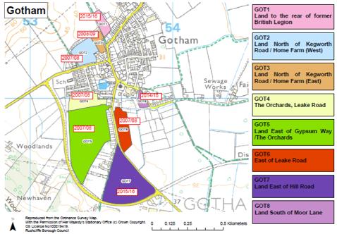
8 8
9 Site Name Site Ref SHLAA Reference Purpose Home Farm GOT1 133 and 381 (Local Plan Pt2. Further Options reference GOT2 & GOT3) Old Sc ore Justification Revi sed Scor e Revised Justification Check unrestricted sprawl of Prevent merging of Assist in safeguarding the countryside from encroachment Preserve setting and special character of historic settlement 1 This parcel of land adjoins Gotham on three sides, with the former school, properties on Nottingham Road and properties on Home Farm Close/Kegworth Road enclosing the site. Development would round of the settlement in this area. The land is contained by a path which follows a disused railway line and established hedgerow. These provide a robust exterior boundary. 1 Development would only extend a limited distance north towards Barton-in-Fabis beyond properties on Nottingham Road and Kegworth Road. Reduction in distance is insignificant. Gotham Hill is a significant topographical feature between Gotham and to the north. Should development occur north of Gotham, this prominent hill prevents any perception of merging. 2 Land contains a substantial telephone exchange building. The edge of Gotham is prominent. Whilst the land is in use for the grazing of horses it is considered to be settlement fringe. 4 This open space is close to the historic core of Gotham, contributing to the historic rural character of the village. It also forms part of the setting of the former school which is Grade II listed. This area of open pasture (with includes pre-enclosure ridge and furrow) also forms an important part of the agricultural setting for Home Farm which is identified as a local interest building. 3 This parcel of land consists of 2 plots. The first adjoins Gotham on two sides, with a public footpath between it and the former school and school house. Home Farm and 2 properties on Home Farm Close are also adjoined. The second plot adjoins Gotham for part of one of it's boundaries with properties along Nottingham Road. Gotham is characterised by the established irregular outline of the built up area and these plots form an important part of that feature. Both plots are contained to the north by a path which follows the disused railway line a non designated heritage asset with established hedgerows. These provide a robust exterior boundary. 1 No change 5 One of the plots contains a substantial telephone exchange building. The land rises away from Kegworth Road towards Gotham Hills and with the exception of the School House and Manor Farm the settlement's edge is not prominent and has the appearance of open countryside. 5 No change but score higher due to the ridge and furrow 9
10 Assist in urban regeneration 3 There are no specific urban regeneration projects within Gotham. 3 No change Score 11 Low-medium 17 Medium-high Conclusion Old Conclusion (numbering is from the GB Further Options Doc.) The enclosure of this parcel of Green Belt land on three sides and its robust rear boundary significantly reduces its performance against the purposes of checking unrestricted sprawl and the prevention of merging The enclosure of the site by prominent residential developments and the presence of the telephone exchange also reduce its performance against the purpose of safeguarding countryside Whilst the land is important to the setting of the former school (Grade II listed) and Home Farm (a local interest building) this does not increase its above a low-medium importance. This is reflected in a score of 11. Revised Conclusion The enclosure of the two plots on 2 sides and the position of the plot wrt the established irregular outline of Gotham increases its performance against the purposes of checking unrestricted sprawl. The nature of the ground rising away from the Kegworth Road towards Gotham Hills increases the performance against the purpose of safeguarding the countryside. The land is important to the setting of the former school (Grade II listed) and Home Farm (a local interest building) as well as the non heritage disused railway line asset and the prominent preenclosure ridge and furrow increases its to a medium-high importance. This is reflected in a score of
11 Site Name Site Ref SHLAA Reference Purpose Land behind the former British Legion GOT2 851 (Local Plan Pt2. Further Options reference GOT1) Old Sc ore Justification Revi sed Scor e Revised Justification Check unrestricted sprawl of Prevent merging of Assist in safeguarding the countryside from encroachment Preserve setting and special character of historic settlement Assist in urban regeneration 1 This parcel of land shares two boundaries with Gotham the former British Legion to the south and sports pavilion to the east. Site is contained by track which links Gotham to Gotham Hill, telephone exchange (within the southern area of the site) and sports pavilion. 1 Development would only extend a limited distance beyond the sports pavilion towards Barton in Fabis. Reduction in distance is insignificant. Gotham Hill is a significant topographical feature between Gotham and to the north. Should development occur north of Gotham, this hill prevents any perception of merging. 4 The land was previously used by British Gypsum as part of their operations. The site has however naturally regenerated and does not contain any inappropriate development. The edge of Gotham is visible from locations within the southern area of the site. The majority of the site contains shrubs and young trees which enclose the site, creating a sense of open countryside. 1 There are no heritage assets within the site or within locations that would be affected by the removal of this area of land from the. 3 There are no specific urban regeneration projects within Gotham. 2 This parcel of land shares two boundaries with Gotham the former British Legion to the south and sports facilities and car park to the east. Site is contained to the west by a track which links Gotham to Gotham Hill and to the south of this boundary the telephone exchange. Development of this parcel would enhance the established irregular nature of the built up area of Gotham. 1 No change 4 No change 1 No change 3 No change Score 10 Low-medium 11 Low-medium 11
12 Conclusion Old Conclusion (numbering is from the GB Further Options Doc.) The site is enclosed by development on three sides with the Community Centre and Sports Pavilion to the east, British Legion to the south and Telephone Exchange to the west (on the southern half of this boundary). The presence of these strong boundaries reduces the s importance against restricting sprawl and preventing the merging of The site should score lower overall, however the land has naturally regenerated and the site is countryside in character rather than settlement fringe. The overall score of 10 reflects land which is of low importance. Revised Conclusion The site is enclosed by development on three sides with the Community Centre and Sports Pavilion to the east, British Legion to the south and Telephone Exchange to the west (on the southern half of this boundary). The presence of these strong boundaries reduces the s importance against restricting sprawl and preventing the merging of. Development would enhance the established irregular nature of the Gotham built up area The site should score lower overall, however the land has naturally regenerated and the site is countryside in character rather than settlement fringe. The overall score of 11 reflects land which is of low importance. 12
13 Site Name Site Ref SHLAA Reference Purpose Moor Lane GOT3 700 (Local Plan Pt2. Further Options reference GOT8) Old Sc ore Justification Revi sed Scor e Revised Justification Check unrestricted sprawl of Prevent merging of Assist in safeguarding the countryside from encroachment Preserve setting and special character of historic settlement Assist in urban regeneration 1 This area of shares two boundaries with Gotham (along Moor Lane and new residential properties at Home Farm). The northern half of the site is contained by development on both sides. It is enclosed by residential development on Moor Lane and residential development at Manor Farm. An access track, fencing, ditch and hedge provide a robust external boundary. The western boundary is a weaker fence, however the Rectory behind prevents sprawl in this direction. Development of the site could round off this part of the settlement. 1 The area is small and development does not extend south beyond Moor Lane. The Green belt does not perform the function to prevent merging in this particular location 3 Land does not contain any inappropriate development. Whilst properties on Moor Lane are screened by a substantial hedgerow/ tree belt, the new residential properties at Manor Farm are prominent and the land is settlement fringe rather than open countryside. 1 Whilst in close proximity to the historic core, there are no heritage assets within the site, or within locations that would be affected by the removal of this area of land from the. Modern development at Manor Farm separates the area from the historic core. 3 There are no specific urban regeneration projects within Gotham. 1 No change 1 No change 3 No change 1 No change 3 No change Score 9 Low-medium 9 Low-medium 13
14 Conclusion Old Conclusion (numbering is from the GB Further Options Doc.) Similarly to GOT1 and 2, GOT3 is enclosed by development on three sides with residential development on the opposite side of Moor Lane and the new properties at Manor Farm. This prevents sprawl and, if developed, there would be no reduction in the distance between Gotham and to the south. The presence of a robust boundary to the south provides added security against unrestricted sprawl The absence of inappropriate development indicates the designation has safeguarded the countryside form encroachment, however the edge of Gotham is an overriding feature and this reduces the importance of safeguarding this area of countryside from encroachment Because of these factors the land scored 9 and is of low importance. Revised Conclusion No change 14
15 Site Name Site Ref SHLAA Reference Purpose Land east of Leake Road GOT4 135 (Local Plan Pt2. Further Options reference GOT6) Old Sc ore Justification Revi sed Scor e Revised Justification Check unrestricted sprawl of Prevent merging of Assist in safeguarding the countryside from encroachment Preserve setting and special character of historic settlement Assist in urban regeneration 4 Land shares two boundaries with Gotham (along Leake Road and a shorter distance adjacent to The Rectory). This area is of prevents significant development on the east side of Leake Road and provides views across the countryside towards East Leake s Gypsum Works. The whole of the field has not been submitted by the developer and does not follow any external boundary feature. 1 The land is opposite ribbon development along Leake Road, extending a limited distance beyond the junction with Hill Road, where development on Leake Road ends. There are no inset south of Gotham within the. East Leake is 2.5km and outside the. 4 There is no inappropriate development within the site. Whilst the edge of Gotham is visible along Leake Road, this area of Green Belt is part of an open arable landscape with extensive views from Leake Road of the countryside south and east. The character of the land is open countryside. 2 There are no heritage assets within the site. The land however, does form the setting for the historic core of Gotham (Church and Rectory) when approaching along Leake Road. 3 There are no specific urban regeneration projects within Gotham. 4 No change 1 No change 4 No change 2 No change 3 No change Score 14 Low-medium 14 Low-medium 15
16 Conclusion Old Conclusion (numbering is from the GB Further Options Doc.) The open countryside character of the land and the absence of an external boundary results in the designation performing well against the purposes of checking unrestricted sprawl and safeguarding the countryside from encroachment The existence of development along Leake Road and the absence of significant heritage issues however reduce the Green Belts overall importance. The land scores 14 reflecting a site which is within the higher range of sites that are of low-medium importance. Revised Conclusion No change 16
17 Site Name Site Ref SHLAA Reference Purpose Land west of Leake Road GOT5 849 (Local Plan Pt2. Further Options reference GOT7) Old Sc ore Justification Revi sed Scor e Revised Justification Check unrestricted sprawl of Prevent merging of Assist in safeguarding the countryside from encroachment Preserve setting and special character of historic settlement Assist in urban regeneration 4 The land shares one boundary with Gotham. The western boundary adjoins Hill Road only Whilst a prominent intrusion into the open countryside, the site is flat and contained on all three sides by Hill Road, Leake Road and Gypsum Way. These are robust and permanent boundaries which are further strengthened by significant tree planting and hedgerows. 1 There are no inset south of Gotham within the. East Leake is 2km and outside the. The removal of land south of Gotham and the perception of merging is prevented by the West Leake Hills and Crows Wood Hill. 4 The edge of Gotham is screened and the character of the land is open countryside. 1 There are no heritage assets within the site or within locations nearby that would be affected by the removal of this area of land from the. 3 There are no specific urban regeneration projects within Gotham. 4 No change 1 No change 4 No change 1 No change 3 No change Score 13 Low-medium 13 Low-medium 17
18 Conclusion Old Conclusion (numbering is from the GB Further Options Doc.) Although this parcel of land is a significant size, it is contained by robust and permanent road boundaries and is located between residential development on Hill Road and industrial estate on Gypsum Way The land scored poorly against merging as there are no south of Gotham within the and the presence of national grid power lines reduce the lands rural character The site scored 13 reflecting a Green Belt area that is of low-medium importance. Revised Conclusion No change 18
19 Site Name Site Ref SHLAA Reference Purpose Land east of Gypsum Way GOT6 132 (Local Plan Pt2. Further Options reference GOT5) Old Sc ore Justification Revi sed Scor e Revised Justification Check unrestricted sprawl of Prevent merging of Assist in safeguarding the countryside from encroachment Preserve setting and special character of historic settlement 1 The rear gardens of properties along Leake Road, a Bus Depot and rear gardens of properties along Hill Road form the east and south east boundary of this area of. Land is contained by Gypsum Way to the west which provides a robust and permanent external boundary. Site comprises five fields separated by mature hedgerows. 1 The nearest settlement west of Gotham is Ratcliffe-on-Soar, a small hamlet adjacent to the power station. The removal of this land would only result in a minor reduction in the distance between these. Containment by the Gypsum Way west of the land and the West Leak Hills and Gotham Hill further reduces the perception of Gotham merging with west. 3 Land contains residential dwellings behind Eyres Lane, and commercial nursery. Whilst the edge of Gotham is visible within some fields, notably the Depot and nursery, the properties on Leak Road and Hill Road are set back from the boundary. Traffic on Gypsum way is also screened by the substantial tree belt. Due to the site s enclosed pastoral character and its external and internal screening by hedgerows, the land is open countryside in character. 1 There are no heritage assets within the site, or within locations nearby that would be affected by the removal of this area of land from the. 4 A Bus Depot, properties along Leake Road, rear gardens of properties along Hill Road and an SSI form the east and south east boundary of this location The northern boundary is formed by the boundary hedge with site GOT7. The western boundary follows the disused railway line with mature hedgerows. Before the completion of Gypsum Way the site was connected to the open countryside of the West Leake Hills and remains visually connected to this green space. Site comprises five fields separated by mature hedgerows. 1 No change 4 Land contains residential dwellings behind Eyres Lane and a commercial nursery. The edge of Gotham is visible within some fields, notably the Depot and nursery, and the properties on Leake Road. The properties on Hill Road are set back from the boundary. Due to the site s enclosed pastoral character and its external and internal screening by hedgerows, the land is open countryside in character. The western boundary follows the disused railway line a non designated heritage asset with established hedgerows and the Logan Way extension (proposed). 5 The northern field has prominent preenclosure ridge and furrow. 19
20 Assist in urban regeneration 3 There are no specific urban regeneration projects within Gotham. 3 Score 9 Low 17 Medium-high Old Conclusion This large area of west of Gotham is screened from view by substantial tree belts, is internally subdivided by mature hedgerows and is contained by the Gypsum Way. These factors reduce the importance of the Green Belt designation to the restriction of sprawl and preventing the merging of The screening of the land from external viewpoints and the pastoral fields however increase the perception that, from within the site, the land is open countryside Whilst substantial the performs poorly against 3 of the 5 Green Belt purposes and consequently is deemed to be of low importance Revised Conclusion This large area of west of Gotham, is internally subdivided by mature hedgerows and is contained by the Gypsum Way. A parcel of this size could increase the size of Gotham by up to 50% and therefore would constitute urban sprawl. It would also reduce the intrinsic established irregular nature of Gotham's built up environment. The screening of the land from external viewpoints and the pastoral fields however increase the perception that, from within the site, the land is open countryside. Also the parcel contains a number of existing developments and includes one field of pre-enclosure ridge and furrow The parcel performs well against 3 of the 5 purposes and consequently is deemed to be of Medium-high importance 20
21 Site Name Site Ref SHLAA Reference Purpose Land south of Hall Drive GOT7 134 (Local Plan Pt2. Further Options reference GOT4) Old Sc ore Justification Revi sed Scor e Revised Justification Check unrestricted sprawl of Prevent merging of Assist in safeguarding the countryside from encroachment Preserve setting and special character of historic settlement Assist in urban regeneration 1 Shares two boundaries with Gotham (rear of properties along Pygall Avenue and Monks Lane). The land is contained by Gypsum Way and tree belts to the east and an established hedgerow to the south. The land comprises two fields split by a mature hedgerow. 1 The nearest settlement west of Gotham is Ratcliffe-on- Soar, a small hamlet adjacent to the power station. The removal of this land would only result in a minor reduction in the distance between these. Containment by the Gypsum Way west of the land and the West Leak Hills and Gotham Hill further reduces the perception of Gotham merging with west. 2 Land does not contain inappropriate development. The edge of Gotham is visible and prominent, most notably within the field adjacent to properties on Pygall Avenue. 1 Apart from ridge and furrow, there are no heritage assets within the site, or within locations nearby that would be affected by the removal of this area of land from the Green Belt. 3 There are no specific urban regeneration projects within Gotham Shares one long boundary with Pygall Avenue and a short boundary with Monks Lane (2 properties). The land is contained by the old railway line a historic non-designated heritage asset and tree belts to the east and an established hedgerow to the south. Before the completion of Gypsum Way the site was connected to the open countryside of the West Leake Hills and remains visually connected to this green space. The land comprises two fields split by a mature hedgerow. 1 The nearest settlement west of Gotham is Ratcliffe-onSoar, a small hamlet adjacent to the power station. The removal of this land would only result in a minor reduction in the distance between these. Containment by the Gypsum Way west of the land and the West Leake Hills and Gotham Hill further reduces the perception of Gotham merging with west. 3 Land does not contain inappropriate development. The edge of Gotham is visible and prominent, most notably within the field adjacent to properties on Pygall Avenue. The wider countryside to the west is screened from view by the route of the Gotham railway a historic non-designated heritage asset and the hedgerows along it. Before the completion of Gypsum Way this area belonged to an area of open countryside stretching to the West Leake Hills 5 Both fields have extensive and very well defined 'ridge and furrow' features an important heritage asset which would be destroyed by any development. The route of the Gotham railway a historic non-designated heritage asset runs along the western boundary of the site. 3 There are no specific urban regeneration projects within Gotham
22 Score 8 Low 16 Low-medium Conclusions Old Conclusion (numbering is from the GB Further Options Doc.) This area of shares two boundaries with Gotham and is contained by an established tree belt and Gypsum Way beyond. As the area does not extend west beyond Pygall Avenue and is well contained by these physical boundaries, the importance of the against the purposes of restricting sprawl and the prevention of merging is significantly reduced The edge of Gotham is a prominent feature within the adjacent field however this only results in a score of two Overall the land scored poorly against purposes and reflects the lands low importance. Revised Conclusion This area of shares two boundaries with Gotham and the old railway line a historic nondesignated heritage asset. Logan Way and important new footpath will run along this section of the old railway. The southern boundary is an established hedgerow. If developed the land would compromise the irregular nature of the village and would therefore not safeguard the countryside from encroachment. The fields contain one of the most prominent ridge and furrow assets in the area which should be preserved and lead to a score of 5 for the preservation of the special character of the historic settlement. Overall the land scored well against purposes and reflects the lands low-medium Green Belt importance. 22
23 References and links to related documents (it's easiest to either search for the document or to use the shortened url of the form bit.ly/xxxx) Department for Communities and Local Government National Planning Policy Framework - uploads/attachment_data/file/6077/ pdf or Rushcliffe Borough Council Local Plan Pt. 1 Core Strategy (adopted) - media/documents/pdf/planningandbuilding/planningpolicy/corestrategyexamination/9%20local %20Plan%20Part%201%20Rushcliffe%20Core%20Strategy.pdf or Local Plan Pt.2 Land and Planning Policies (Issues and Options) planningpolicy/lapp/rushcliffe%20lapp_final_low%20res.pdf or Local Plan Pt.2 Land and Planning Policies (Further Options) - planningpolicy/lapp/furtheroptions/further%20options%20final.pdf or Review Further Sites - documents/pdf/planningandbuilding/planningpolicy/lapp/furtheroptions/gb%20review_further %20sites_final%20Feb% pdf or Neighbourhood Planning Site - neighbourhoodplanning/ or Plans for the large developments including Clifton South - planningandgrowth/potentiallargedevelopments/ or Strategic Housing Land Availability Assessment (2106) - media/rushcliffe/media/documents/pdf/planningandbuilding/planningpolicy/monitoring/full %20SHLAA%20report% pdf or Residential Design Guide - pdf/planningandbuilding/residential_design_guide.pdf or Gotham Rural Housing Needs Survey - documents/pdf/housing/ruralhousingneeds/gotham%20hns% pdf or Affordable Housing in Rural Communities (a guide for Parish Councils) %20Guide%202017%20FINAL.pdf or Notts County Council Gotham Heritage Assets documented by NCC can be found on the Heritage Gateway. These include listed buildings, archaeological sites and finds, important old buildings, ridge and furrow assets etc. Enter Gotham into the search facility at The Rushcliffe Biodiversity Opportunity Mapping Report (2015) or Council for the Protection of Rural England 23
24 What's Special to you (Landscape Issues in your Neighbourhood Plan) or 24
Toddington Central Bedfordshire Stage 3 Green Belt Study December 2017
 Toddington Central Bedfordshire Stage 3 Green Belt Study December 2017 Site: ALP086 - Middle Lakes, Toddington Site size (ha): 2.83 Site: ALP086 - Middle Lakes, Toddington Site size (ha): 2.83 Site description
Totternhoe Central Bedfordshire Stage 3 Green Belt Study December 2017
 Totternhoe Central Bedfordshire Stage 3 Green Belt Study December 2017 Site description The site is comprised of a single arable field on the southern side of the washed over settlement of Totternhoe.
Neighbourhood Planning Site Assessment Pro-forma and Guide Version 2
 Neighbourhood Planning Site Assessment Pro-forma and Guide Version 2 September 2014 Site HNP 006 Land East of Stanbridge Road and North of Lower Road 1. Background information Site location and use Site
Neighbourhood Plan Representation
 Date: 10 th November 2017 Neighbourhood Plan Representation Land to the east of Callow Hill Road, Alvechurch Introduction This representation has been prepared by RPS Planning and Development on behalf
viii Figure ES1: Recommended changes to Green Belt boundaries in Waverley
 viii Figure ES1: Recommended changes to Green Belt boundaries in Waverley 50 3.4 Elstead (segments W5, W11, W18, W19) 3.4.1 Area of search 51 3.4.2 Assessment against Green Belt criteria Segment W5: land
Longhorsley Neighbourhood Plan
 Site Assessment 1. The availability of the site 1.1 Is the land owner willing for their site to be made available for development? 1.2 If yes, do you have any written evidence to back this up? Planning
LEEDS SITE ALLOCATIONS PLAN MATTER 3 GREEN BELT KCS DEVELOPMENT AUGUST 2017
 LEEDS SITE ALLOCATIONS PLAN MATTER 3 GREEN BELT KCS DEVELOPMENT AUGUST 2017 Smith Limited Suite 9C Joseph s Well Hanover Walk Leeds LS3 1AB T: 0113 2431919 F: 0113 2422198 E: planning@peacockandsmith.co.uk
Ashtead Neighbourhood Forum Site Assessment AS07 Old Chalk Pit, Pleasure Pit Road. Site ref: AS07 Site address: Old Chalk Pit, Pleasure Pit Road
 Site ref: AS07 Site address: Old Chalk Pit, Pleasure Pit Road Proposed Land Use: Total Site Area (Ha): Housing 0.7ha Description: The site was formally an old chalk pit that has been partially filled and
Site Assessment Technical Document Appendix A: Glossary
 Central Bedfordshire Council www.centralbedfordshire.gov.uk Site Assessment Technical Document Appendix A: Glossary July 2017 1.1.11-1 - ii Appendix A: Glossary Term Agricultural Land Classification AONB
Oxford Green Belt Study. Summary of Final Report Prepared by LUC October 2015
 Oxford Green Belt Study Summary of Final Report Prepared by LUC October 2015 Project Title: Oxford Green Belt Study Client: Oxfordshire County Council Version Date Version Details Prepared by Checked by
Site ref: AS06 Site Name or Address: Murreys Court, Agates Lane
 Site ref: AS06 Site Name or Address: Murreys Court, Agates Lane Proposed Land Use: Total Site Area (Ha): Housing 1.85 Ha Description: It is understood that the owner has no plans to dispose of the site
Warwickshire County Council. Upper and Lower Brailes. Landscape Study
 Warwickshire County Council Upper and Lower Brailes Landscape Study Produced by WCC Landscape Architects March 2016 Landscape Assessment of Potential Development Sites within the parish of Brailes 1.0
DUNSFOLD NEIGHBOURHOOD PLAN Site Selection Policies
 DUNSFOLD NEIGHBOURHOOD PLAN Site Selection Policies The criteria for assessing sites for future housing and business development in Dunsfold are set out below. (Development criteria, covering what it is
Cookham Parish Council s Response to The Draft Local Borough Plan
 Cookham Parish Council s Response to The Draft Local Borough Plan As Agreed at the Planning Committee Meeting on 10 th January 2017. Designation of Poundfield as a Local Green Space The Parish Council
Introduction. Grounds of Objection
 Planning application ref. number 18/04496/APP Planning application to Aylesbury Vale District Council for the erection of 17 dwellings and associated works to the South of Hogshaw Road Granborough. Granborough
GUILDFORD BOROUGH GREEN BELT AND COUNTRYSIDE STUDY
 GUILDFORD BOROUGH GREEN BELT AND COUNTRYSIDE STUDY Volume II - Addendum On behalf of Guildford Borough Council PPG Ref : BNL.0287 April 2014 COPYRIGHT The conents of this document must not be copied or
Settlement Boundaries Methodology North Northumberland Coast Neighbourhood Plan (August 2016)
") Introduction This background paper sets out a methodology for the definition of settlement boundaries in the North Northumberland Coast Neighbourhood Plan. The neighbourhood plan is planning positively
Introduction This background paper sets out a methodology for the definition of settlement boundaries in the North Northumberland Coast Neighbourhood Plan. The neighbourhood plan is planning positively
Plumpton Neighbourhood Development Plan Revised Pre Submission Document - Regulation 14 Consultation
 REPRESENTATIONS... Plumpton Parish Council Plumpton Neighbourhood Development Plan Revised Pre Submission Document - Regulation 14 Consultation Representations submitted on behalf of: Cala Homes (South
DEVELOPMENT MANAGEMENT REPORT
 ITEM A08-1 DEVELOPMENT MANAGEMENT REPORT TO: BY: DATE: DEVELOPMENT: SITE: WARD: APPLICATION: APPLICANT: Development Management Committee Development Manager Proposed live/work unit in connection with existing
STATEMENT OF OBJECTION TO THE PROPOSED DEVELOPMENT OF LAND AT CHURCH CLIFF DRIVE FILEY
 STATEMENT OF OBJECTION TO THE PROPOSED DEVELOPMENT OF LAND AT CHURCH CLIFF DRIVE FILEY You will be aware that Scarborough borough council have adopted a new local plan that includes land at Church Cliff
Environmental and Landscape Mapping
 Environmental and Landscape Mapping In support of the Calveley Neighbourhood Plan November 2016 Project Name and Number: Calveley Neighbourhood Plan 16-025 Document Name and Revision: Environmental and
APP/G1630/W/15/
 Appeal Decision Site visit made on 20 October 2015 by William Fieldhouse BA (Hons) MA MRTPI an Inspector appointed by the Secretary of State for Communities and Local Government Decision date: 20 November
Ashtead Neighbourhood Forum Site Assessment AS03 Lime Tree Lodge, Farm Lane. Site address: Lime Tree Lodge, Farm Lane. Proposed Land Use:
 Site ref: AS03 Site address: Lime Tree Lodge, Farm Lane Proposed Land Use: Total Site Area (Ha): Housing 1.25ha Description The site is located off Farm Lane at the junction with Park Lane. To the north
Neighbourhood Planning Local Green Spaces
 Neighbourhood Planning Local Green Spaces Introduction... 2 1. Why green space is important... 4 2. Neighbourhood plans and green space... 6 3. Evidence... 8 Statutory designations... 9 Green space audit...
Table of Allocated Housing Sites
 Draft as of 0 November 016 Table of Allocated Housing s Name Green 1 (30, 33, 10, 169, 36/ 100) Barratt s Farm Balsall Common Yes 57 800 Includes existing park. Listed buildings to edge of site. of search
SOUTH EAST LINCOLNSHIRE LOCAL PLAN: HOUSING PAPER DONINGTON (JUNE 2016)
") SOUTH EAST LINCOLNSHIRE LOCAL PLAN: HOUSING PAPER DONINGTON (JUNE 2016) 1 DONINGTON S PLACE IN THE SPATIAL STRATEGY 1.1 Policy 2 of the South East Lincolnshire Local Plan 2011-2036 Draft for Public Consultation
SOUTH EAST LINCOLNSHIRE LOCAL PLAN: HOUSING PAPER DONINGTON (JUNE 2016) 1 DONINGTON S PLACE IN THE SPATIAL STRATEGY 1.1 Policy 2 of the South East Lincolnshire Local Plan 2011-2036 Draft for Public Consultation
The targets do not adhere to the government projections or methodology, being aspirational rather than achievable.
 Question 1: Preferred Growth Option (see pages 7-9 of the consultation document) Do you agree with the preferred growth option for the Joint Local Plan? The targets do not adhere to the government projections
LONGDEN VILLAGE DEVELOPMENT STATEMENT
 LONGDEN VILLAGE DEVELOPMENT STATEMENT 2017-2027 1 Longden Development Statement 2017-2027 15/01/18 1. Background 1.1 Longden Village Longden village is a very rural and traditional community first mentioned
ENVIRONMENTAL AND LANDSCAPE MAPPING
 APPENDIX IV : Environmental and Landscape Mapping ENVIRONMENTAL AND LANDSCAPE MAPPING Calveley Neighbourhood Plan November 2016 ENVIRONMENTAL AND LANDSCAPE MAPPING Calveley Neighbourhood Plan Calveley
Proposed Sheffield City Region Combined Green Belt Review A Common Approach August 2014
 Proposed Sheffield City Region Combined Green Belt Review A Common Approach August 2014 1.1 Purpose To achieve the principles of Duty to Cooperate, it is beneficial for all Local Authorities within the
Planning and Regulatory Committee 20 May Applicant Local Councillor Purpose of Report
 Planning and Regulatory Committee 20 May 2014 7. APPLICATION FOR PLANNING PERMISSION FOR THE CARRYING-OUT OF DEVELOPMENT PURSUANT TO PLANNING PERMISSION REFERENCE NUMBER 603451 DATED 28 FEBRUARY 2007 WITHOUT
Great Easton Sustainable Housing Development Sites - Site Seven, Broadgate extension site SHLAA Ref HSG/03)
") Great Easton Sustainable Housing Development Sites - Site Seven, Broadgate extension site SHLAA Ref HSG/03) 1. Introduction The Great Easton Neighbourhood Plan Group are preparing a Neighbourhood Plan
Great Easton Sustainable Housing Development Sites - Site Seven, Broadgate extension site SHLAA Ref HSG/03) 1. Introduction The Great Easton Neighbourhood Plan Group are preparing a Neighbourhood Plan
Variation No 1: Dundalk & Environs Development Plan Core Strategy
 Variation No 1: Dundalk & Environs Development Plan 2009-2015 Core Strategy Adopted on 29 th August 2011 CONTENTS Page Section 1 1.0 Synopsis 1 1.1 Background Document 1 1.2 Variation of Dundalk and Environs
SOUTH CAMBRIDGESHIRE DISTRICT COUNCIL. Planning and New Communities Director
 SOUTH CAMBRIDGESHIRE DISTRICT COUNCIL REPORT TO: Planning Committee 5 June 2013 AUTHOR/S: Planning and New Communities Director S/0747/13/FL HISTON Construction of Car Park at Histon Baptist Church, Station
Public Consultation. Land at Monks Farm, North Grove. Welcome
 Welcome Welcome to our public exhibition for development on Land at Monks Farm, orth Grove. Gallagher Estates and Gleeson Strategic Land are preparing an outline planning application for new homes, open
Suffolk Coastal Local Plan Review Issues and Options, August 2017, Public Consultation
 Suffolk Coastal Local Plan Review Issues and Options, August 2017, Public Consultation Having reviewed the issues and options documents, the Society has made the following response: Part 1 - Strategic
Draft for Consultation Site Assessments and Opportunities
 Draft for Consultation Site Assessments and Opportunities Consultation period 29 th April 2016 to 20 th June 2016 29 th April 2016 Overview In assessing sites presented by Aylesbury Vale District Council
SITE ASSESSMENT CHECKLIST
 1. Site Details a. What is the site s name/reference? SITE ASSESSMENT CHECKLIST CR3NPWHY 3007 Gasometer Site Godstone Road CR3 0EG b. Where is the site located? Wyhteleafe; Godstone Road. Urban category1
2015/1020 Mr Edward Cockburn Caravan storage on hardcore base (Retrospective) Ranah Stones, Whams Road, Hazlehead, Sheffield, S36 4HT
 Ranah Stones, Whams Road, Hazlehead, Sheffield, S36 4HT") 2015/1020 Mr Edward Cockburn Caravan storage on hardcore base (Retrospective) Ranah Stones, Whams Road, Hazlehead, Sheffield, S36 4HT Dunford Parish Council have not commented Councillor Andrew Millner
2015/1020 Mr Edward Cockburn Caravan storage on hardcore base (Retrospective) Ranah Stones, Whams Road, Hazlehead, Sheffield, S36 4HT Dunford Parish Council have not commented Councillor Andrew Millner
WELCOME GYPSY LANE. Wider Site Location plan. Proposals for the development of LAND OFF FOXLYDIATE LANE WEBHEATH. Proposals for the development of
 WELCOME The developers are preparing an outline planning application for a residential led development and need the community s views in order to develop the proposals further WHAT IS PROPOSED? A high
PONTELAND NEIGHBOURHOOD PLAN LANDSCAPE QUALITY ASSESSMENT
 PONTELAND NEIGHBOURHOOD PLAN LANDSCAPE QUALITY ASSESSMENT UPDATED CONSULTATION ISSUE NOVEMBER 2016 CONTENTS 2 Introduction 2 Methodology 4 Landscape Quality Areas Plan 5 Landscape Quality Area 1 SMALLBURN
Land at Fiddington Hill Nursery, Market Lavington
 Land at Fiddington Hill Nursery, Market Lavington Briefing Report for Market Lavington Parish Council Persimmon Homes (Wessex) April 2016 Background This brief report has been prepared following the Market
Ashtead Neighbourhood Forum Site Assessment AS14 Land at The Pines, Farm Lane. Site ref: AS14 Site address: Land at The Pines, Farm Lane
 Site ref: AS14 Site address: Land at The Pines, Farm Lane Proposed Land Use: Total Site Area (Ha): Housing 2.1ha Description: The site is located to the east of Ashtead off Farm Lane and is currently grassed.
Effingham Neighbourhood Plan 1. Basic Conditions Statement
 Effingham Neighbourhood Plan 1 Basic Conditions Statement Effingham Neighbourhood Plan 2016: Basic Conditions Statement 2 Contents This statement has been prepared by Effingham Parish Council to accompany
Derry City and Strabane District Council Planning Committee Report
 Derry City and Strabane District Council Planning Committee Report COMMITTEE DATE: 29 th November 2017 APPLICATION No: APPLICATION TYPE: PROPOSAL: LOCATION: APPLICANT: AGENT: LA11/2016/0854/O Outline Shared
About 10% of the Borough's population lives in the seven rural parishes. Population figures from the 1991 census are given below:-
 8. THE DISTRICT VILLAGES 8.1 Population About 10% of the Borough's population lives in the seven rural parishes. Population figures from the 1991 census are given below:- Village No. of Persons Cottingham
Planning and Sustainability Statement
 Land adjacent to Manor Farm, Catterick Village Pallett Hill Sand and Gravel Co Ltd Proposed 10 new dwellings, (6 No market dwellings and 4 No affordable dwellings) with access, associated car parking and
Briefing Document of CNP. June 2017
 Cholsey Parish Council Cholsey Neighbourhood Plan Briefing Document of CNP June 2017 Cholsey Neighbourhood Plan Page! 1 of! 8 Cholsey Plan Briefing v1.4 Page Left Intentionally Blank Cholsey Neighbourhood
WELCOME. Land North of STEVENAGE. We would like to thank you for attending our public exhibition today.
 WELCOME We would like to thank you for attending our public exhibition today. The purpose of this event is to share our proposals and hear your thoughts on our ideas. Members of the project team are on
Chapter 2: OUTLINE PLANNING APPLICATION PROPOSALS. A New Garden Neighbourhood Matford Barton 17
 Chapter 2: OUTLINE PLANNING APPLICATION PROPOSALS A New Garden Neighbourhood Matford Barton 17 2.1. SUMMARY AND STATUS OF THE PROPOSALS 2.1.1. The parameter plans and associated wording in this chapter
Bradleys Both Parish Council
 Bradleys Both Parish Council Bradleys Both Housing Site Assessments April 2015 Contents 1.0 Introduction... 2 2.0 BR001 Health Lea and Land to Rear, Skipton Road... 2 3.0 BR002 Holly Tree House and Land
What do you like about South Marston?
 What do you like about South Marston? What you have said so far: Strong and separate identity, distinct from Swindon Village character (Church, School, Green and Hall) Surrounding working countryside and
PLANNING COMMITTEE DATE: 07/09/2015 REPORT OF THE SENIOR MANAGER PLANNING AND ENVIRONMENT SERVICE CAERNARFON. Number: 4
 Number: 4 Application Number: C15/0034/37/LL Date Registered: 21/05/2015 Application Type: Full - Planning Community: Llanaelhaearn Ward: Llanaelhaearn Proposal: Location: Summary of the Recommendation:
To secure a Green Belt around Cambridge whose boundaries are clearly defined and which will endure for the plan period and beyond.
 4. GREEN BELT OBJECTIVES GB/a GB/b GB/c GB/d To secure a Green Belt around Cambridge whose boundaries are clearly defined and which will endure for the plan period and beyond. To maintain the purposes
Droitwich Spa 6. Reasoned Justification
 87 Droitwich Spa 6 Reasoned Justification 6.1 Droitwich Spa is identified in the settlement hierarchy (Policy SWDP1) as a main town being the largest settlement in Wychavon District with an estimated population
And now... The KEY Arguments in. Greater Detail
 And now... The KEY Arguments in Greater Detail 'Exceptional Circumstances' Are Needed to Change the Green Belt EBC justification to build on Green Belt is based on: SHMA guestimate of housing needs for
Parish of Repton NEIGHBOURHOOD DEVELOPMENT PLAN
 Parish of Repton NEIGHBOURHOOD DEVELOPMENT PLAN BASIC CONDITIONS STATEMENT December 2018 CEF 4 Legal Requirements This statement has been produced by the NDP Working Group on behalf of Repton Parish Council
Derry City and Strabane District Council Planning Committee Report
 Derry City and Strabane District Council Planning Committee Report COMMITTEE DATE: 23 rd March 2016 APPLICATION No: APPLICATION TYPE: PROPOSAL: LOCATION: APPLICANT: LA11/2015/0395/F Residential Development
PLANNING COMMITTEE REPORT
 PLANNING COMMITTEE REPORT TO: BY: Planning Committee South Head of Development DATE: 19 December 2017 DEVELOPMENT: SITE: WARD: APPLICATION: APPLICANT: Conversion of existing water storage reservoir to
Plumpton Neighbourhood Plan Site Assessment Report
 Plumpton Neighbourhood Plan Site Assessment Report May 2016 1 Contents 1. Introduction 3 2. Methodology 4 2.1 Identification of Potential Sites 4 2.2 Assessment Process 5 2.3 Assessment Criteria 6 2.4
WILMCOTE NEIGHBOURHOOD PLAN
 WILMCOTE NEIGHBOURHOOD PLAN 1. Introduction. 1.1 David Holmes Planning Ltd has been instructed to advise Wilmcote Parish Council, who wish to prepare a Neighbourhood Plan. In particular we are asked to
Development in the Green Belt
 Supplementary Planning Document: Development in the Green Belt Consultation Draft February 2013 Local Development Framework How to comment This document was published on 21st March 2013 and comments should
Ipswich Issues and Options for the Ipswich Local Plan Review, August 2017, Public Consultation
 Ipswich Issues and Options for the Ipswich Local Plan Review, August 2017, Public Consultation Having reviewed the issues and options documents, the Society has made the following response: Part 1 Strategic
Schedule of Planning Applications Committee Date: 23 May Reference: 06/17/0726/F Parish: Hemsby Officer: Mr J Beck Expiry Date:
 Schedule of Planning Applications Committee Date: 23 May 2018 Reference: 06/17/0726/F Parish: Hemsby Officer: Mr J Beck Expiry Date: 22-05-2018 Applicant: Proposal: Site: Mr Gillett Change of use to the
LETTER OF OBJECTION LAND TO THE SOUTH WEST OF FORGE GARAGE, HIGH STREET, PENSHURST, KENT, TN11 8BU
 Senior Planning Officer Andrew Byrne Sevenoaks District Council Community & Planning Services PO Box 183 Argyle Road Sevenoaks Kent TN13 1GN 04 November 2011 Your Ref: 11/02258/FUL For the attention of
SITE ASSESSMENTS. September 2018 SOUTHWATER PARISH COUNCIL BEESON HOUSE, 26 LINTOT SQUARE, SOUTHWATER, RH13 9LA
 September 2018 SITE ASSESSMENTS PREPARED TO ASSIST THE PREPERATION OF THE SOUTHWATER NEIGHBOURHOOD PLAN SOUTHWATER PARISH COUNCIL BEESON HOUSE, 26 LINTOT SQUARE, SOUTHWATER, RH13 9LA INTRODUCTION TABLE
9 Pershore. Introduction. Pershore Abbey
 118 Introduction 9.1 The historic town of Pershore lies on the River Avon and has a population of 7,000 (2009 Mid-Term Population Estimates). The main areas of the town are centred on the Abbey, the bustling
Land North of Hall Road, Rochford. Rochford District Council. Planning Application Index. Prepared on behalf of Bellway Homes Ltd
 Land North of Hall Road, Rochford Rochford District Council Planning Application Index Prepared on behalf of Bellway Homes Ltd April 2010 Land North of Hall Road, Rochford Rochford District Council Scope
Rochford District Council Allocations Development Plan Document: Discussion and Consultation Document Sustainability Appraisal
 Option SWH1 Balanced Communities Option SWH1 1 To ensure the delivery of high quality sustainable communities where people want to live and work Will it ensure the phasing of infrastructure, including
Called-in by Cllr Richard Stay for the following reasons: DETERMINE. Application recommended for refusal
 Item No. 13 APPLICATION NUMBER CB/15/00275/OUT LOCATION Prebendal Farm, Grove Road, Slip End, Luton, LU1 4BZ PROPOSAL Outline Development: Redevelopment of land previously used as a farm yard to residential
Welcome. Land adjacent Sandy Lane WALTHAM CHASE THE PROPOSED SITE
 Land adjacent Sandy Lane WALTHAM CHASE Existing Linden Homes developments Welcome Welcome to Linden Homes Southern s ( Linden ) public exhibition about its proposals for a range of high-quality homes for
CAERNARFON DEPENDENCY CATCHMENT AREA
 CAERNARFON DEPENDENCY CATCHMENT AREA GWYNEDD UNITARY DEVELOPMENT PLAN - HOUSING Map not to scale Dependency Catchment Area Location 2 Caernarfon Topic Housing To the rear of Bro Eglwys, Bethel. Grid Ref.
Test Valley Borough Council Southern Area Planning Committee 8 January 2019
 ITEM 11 APPLICATION NO. 18/02218/FULLS APPLICATION TYPE FULL APPLICATION - SOUTH REGISTERED 23.08.2018 APPLICANT Rugby Football Union SITE The Trojans Club, Stoneham Lane, Eastleigh, SO50 9HT, CHILWORTH
Central Bedfordshire and Luton Green Belt Study Appendix 1
 Central Bedfordshire Council www.centralbedfordshire.gov.uk Central Bedfordshire and Luton Green Belt Study Appendix 1 July 2017-1 - Appendix 1 Stage 1 assessments Central Bedfordshire and Luton Green
Introduction. Welcome to this consultation regarding the draft redevelopment proposals for the former CeramTec factory on Sidmouth Road, Colyton.
 Introduction Welcome to this consultation regarding the draft redevelopment proposals for the former CeramTec factory on Sidmouth Road, Colyton. We are currently considering options for the mixed-use redevelopment
8.0 Design and Form of Development 43/
 42/ 8.0 Design and Form of Development 43/ Rothwells Farm, Golborne/ Development Statement Figure 7. Site Constraints Key 44/ Site Boundary 360 Bus Route/Stops Existing Trees Underground Water Pipe Sensitive
Blandford Forum Town Council, Blandford St Mary Parish Council and Bryanston Parish Council
 Blandford Forum Town Council, Blandford St Mary Parish Council and Bryanston Parish Council Blandford + Neighbourhood Plan 2 Pre-Submission Plan Consultation (November 2018) Representations submitted on
Land at Rampton Road. Cottenham
 Land at Rampton Road Cottenham Introduction TEP is preparing an outline planning application for 54 dwellings on 6.9 hectares of land adjacent to Rampton Road, Cottenham on behalf of the owners Cambridgeshire
OKEFORD FITZPAINE NEIGHBOURHOOD PLAN
 OKEFORD FITZPAINE NEIGHBOURHOOD PLAN Dear Parishioner, The Neighbourhood Plan Project Team have prepared this leaflet to summarise the full Neighbourhood Plan document. It provides a summary of the Vision,
Site ref: AS05 Site address: Ashtead Park Garden Centre, Pleasure Pit Road
 Site ref: AS05 Site address: Ashtead Park Garden Centre, Pleasure Pit Road Proposed Land Use: Total Site Area (Ha): Housing 1.25ha Description: The site is located off Pleasure Pit Road near the junction
BREEDON NORTHERN LIMITED
 Non Technical Summary CONTENTS 1 INTRODUCTION... 1 2 SITE DESCRIPTION... 1 3 DESCRIPTION OF THE DEVELOPMENT... 6 4 NEED FOR THE DEVELOPMENT... 8 5 KEY ISSUES CONSIDERED IN THE ENVIRONMENTAL IMPACT ASSESSMENT...
SPG 1. * the northern and western sections which are open fields used for pasture and grazing;
 SPG 1 1.0 INTRODUCTION This development brief is based on the allocation of the Priors Hall site for employment and countryside recreational purposes in the Corby Borough Local Plan. The brief is intended
Welford-on-Avon Neighbourhood Plan Consultation Event Sunday, 6 April Your name Your address
 Welford-on-Avon Neighbourhood Plan Consultation Event Sunday, 6 April 2014 Your name Your email address Please either: - complete this feedback form and put it in the box before leaving the Memorial Hall
4 RESIDENTIAL ZONE. 4.1 Background
 4 RESIDENTIAL ZONE 4.1 Background The residential areas within the City are characterised by mainly lowrise dwellings sited on individual allotments. Past architectural styles, settlement patterns and
WHITELEY TOWN COUNCIL NORTH WHITELEY DEVELOPMENT SEPTEMBER 2014
 WHITELEY TOWN COUNCIL NORTH WHITELEY DEVELOPMENT SEPTEMBER 2014 Dear Resident This Special Edition of the Whiteley Voice which has been prepared in conjunction with the North Whiteley Consortium is to
Welcome to our exhibition
 Welcome to our exhibition The Homes & Communities Agency (HCA) welcomes you to this public exhibition explaining our proposals for the redevelopment of the former Lea Castle Hospital site. About the Homes
Impact of proposed developments on North Banbury
 Press Release 122 Impact of proposed developments on North Banbury A recently published report Banbury Landscape Sensitivity and Capacity Assessment gives us a better picture of the terrible impact any
Environment Agency Flood Risk Map for the Village of Bridge
 Environment Agency Flood Risk Map for the Village of Bridge December 2016 21 Objective F. Conserving and Enhancing the Natural Environment The National Planning Policy Framework states that the planning
Welcome to our public exhibition
 About our development Welcome to our public exhibition This exhibition gives you the chance to view and comment on our proposals for a new residential development of 165 high-quality homes, along with
Developers and Council attack Southam Road - again
 Press Release 125 Developers and Council attack Southam Road - again Many residents of Hanwell Fields received a letter from the Cherwell District Council yesterday called NEIGHBOURHOOD NOTIFICATION. This
The eight-week period for this application expires on 5 October 2006.
 06/01213/FUL CHANGE OF USE FROM AGRICULTURAL LAND TO PRIVATE CAR PARK AND NEW FENCING. AT Land To The South of Perceval Almhouses, Lower Weald, Calverton FOR Calverton Parochial Church Council INTRODUCTION
BLETCHLEY PARK AREA - DEVELOPMENT FRAMEWORK
 ANNEX A To Item 9 REVISED TEXT: additions shown bold and underlined, deletions in (brackets and in italics). BLETCHLEY PARK AREA - DEVELOPMENT FRAMEWORK This framework sets out the key objectives and requirements
DESIGN & ACCESS STATEMENT
 DESIGN & ACCESS STATEMENT January 2016 Contents Introduction section 1 Section 1 - Introduction Section 2 - Assessment Section 3 - Involvement Section 4 - Evaluation Section 5 - Design Section 6 - Layout
INTRODUCTION. Land south of Bishopswood Lane, Tadley
 0 INTRODUCTION THE SITE Introduction Gladman Developments Ltd. has successfully invested in communities throughout the UK over the past 0 years, developing high quality and sustainable residential, commercial
an Inspector appointed by the Secretary of State for Communities and Local Government
 Appeal Decision Site visit made on 12 November 2015 by Helen Heward BSc Hons MRTPI an Inspector appointed by the Secretary of State for Communities and Local Government Decision date: 27 July 2016 Appeal
SOUTH CAMBRIDGESHIRE DISTRICT COUNCIL. Executive Director / Corporate Manager - Planning and Sustainable Communities
 SOUTH CAMBRIDGESHIRE DISTRICT COUNCIL REPORT TO: Planning Committee 4 th July 2007 AUTHOR/S: Executive Director / Corporate Manager - Planning and Sustainable Communities S/0520/07/F - STAPLEFORD Erection
1. Objectives of this consultation
 1. Objectives of this consultation Provide an update on the results of the December 2014 consultation Provide a summary of the Pre-Submission Plan which is now out for formal consultation To ask for your
Perth and Kinross Council Development Management Committee 20 February 2013 Report of Handling by Development Quality Manager
 Perth and Kinross Council Development Management Committee 20 February 2013 Report of Handling by Development Quality Manager 4(4)(iii) 13/81 Erection of sports hall, associated changing facilities, offices
CA//17/02777/FUL. Scale 1:1,250. Planning Services Canterbury City Council Military Road Canterbury Kent CT1 1YW
 O CA//17/02777/FUL Scale 1:1,250 Map Dated: 15/03/2018 Planning Services Canterbury City Council Military Road Canterbury Kent CT1 1YW AGENDA ITEM NO 16 PLANNING COMMITTEE APPLICATION NUMBER: SITE LOCATION:
Plaistow and Ifold Neighbourhood Plan Pre-Submission Consultation Draft
 Mrs Beverley Weddell Clerk to Plaistow And Ifold Parish Council Lock House Lodge Knightons Lane Dunsfold, GU8 4NU. Dear Mrs Weddell, Our ref: Your ref: Telephone Fax HD/P5402/ 01483 252040 18 th October