17. Coolaney-Rockfield Mini-Plan
|
|
|
- Giles Miller
- 5 years ago
- Views:
Transcription
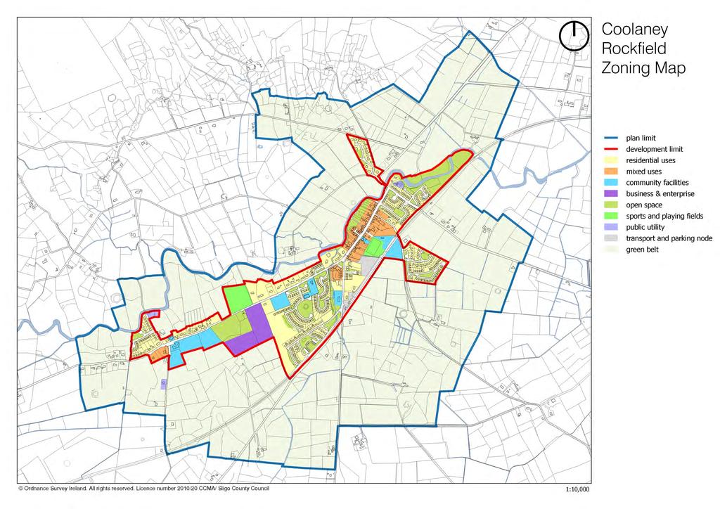
1 County Development Plan Consolidated Draft + Adopted Amendments - August Coolaney-Rockfield Mini-Plan Village profile Coolaney is located approximately 23 km to the south-west of Sligo City, in a designated Rural Area under Urban Influence, on lands classified as normal rural landscape. Rockfield is a small settlement located approximately 1 km west of Coolaney. Given the extent of residential development experienced in recent years, the Coolaney-Rockfield area has been identified as a Gateway Satellite in the County settlement hierarchy (see Section 3.2 of this Plan). The settlement is bounded by the disused Sligo-Limerick railway line (which forms part of the Western Rail Corridor) to the south-east and by the Owenbeg River to the north-west. The river is included within the Unshin River Special Area of Conservation. The historic village core consists of a variety of terraced two-storey buildings along Coolaney s Main Street. In recent years, extensive house-building activity has seen the settlement expand in southwesterly and north-easterly directions. Population and housing There is no specific census data available for the population of the combined Coolaney-Rockfield area. The population of Coolaney increased from 208 in 2006 to 866 in 2011 (an increase of 316 %). According to census information, Coolaney Electoral Division had a population of 550 persons in 2006 (20% higher than the 2002 population of 457) and this increased again to 1,200 in 2011 (an increase of 118%). Surveys undertaken by Council planners in 2015 suggest a village population of circa 1,230 persons, based on 473 occupied units within the development limit. Census 2016 recorded a population of 990 persons in Coolaney (without Rockfield) and 1,331 persons in the Coolaney ED. The significant growth experienced post-2000 can be largely attributed to the Rural Renewal Tax Incentive Scheme, along with the settlement s proximity to Sligo City and the availability of good transport links nearby (Collooney, only 7 km away, provides access to the N-4 and the N1-17 national roads). Newer residential development is in the form of suburban-type estates. The 2015 survey found a vacancy rate of 6% (31 units) compared to the 2009 rate of 13% (57 units). There were also 13 units under construction and planning permission had been granted for a further 40 units approximately. It is considered that there is only limited need for additional residential development during the plan period. 1
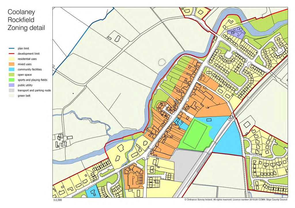
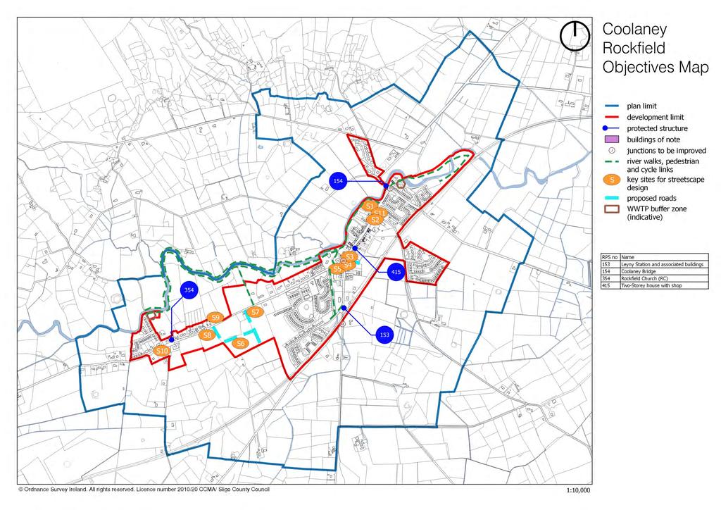
2 County Development Plan Consolidated Draft + Adopted Amendments - August 2017 Community facilities Community facilities in Coolaney-Rockfield consist of a primary school, crèche, community centre, sports field and playground, church, burial ground and health centre. Recent population growth will eventually result in demands for more or enhanced community facilities. Therefore, while some lands have been specifically zoned to accommodate additional community facilities, a flexible approach will be taken towards proposals for community developments on other suitable sites. Commercial and enterprise development Retail and commercial activities are limited to several sole trader outlets, mostly on Coolaney s Main Street. Only one of the retail units in the recently-completed mixed-use complex is currently occupied by a pharmacy, and this is a concern for the Planning Authority. A flexible approach will be adopted with regard to the potential alternative uses of the vacant retail units. There is no tradition of local industry or enterprise providing employment. Efforts to address these deficiencies should be supported and accommodated, where appropriate. Infrastructure Coolaney s local road network provides links to the N-59 (Sligo-Ballina road) to the north-east, and to the N-4 (Sligo-Dublin) and N-17 (Sligo-Galway) roads at Collooney. The main Dublin Sligo railway line can also be accessed from Collooney. The Western Rail Corridor has the potential to improve transport links. Its protection and development are important for the future development of Coolaney- Rockfield. The water supply is sourced from Lough Talt. Coolaney s wastewater treatment plant, built in 2008, has a design capacity of 2,500 PE. Rockfield is served by a smaller installation (250 PE). Both plants have sufficient capacity for foreseeable future. Objectives Note: These objectives must be considered in conjunction with the policies and objectives contained in Volume 1 and the general policies for mini-plans contained in Chapter 1 of Volume 2 of this Plan. It is an objective of Sligo County Council to: 17.1 Natural heritage and open space A. Preserve the views of the Ox Mountains from the designated Scenic Routes L-2801 (Mountain Road), L-6804 (Cloonacool Road) and L-2101 (Collooney Road). B. Protect and enhance the river walk along the Owenbeg River and preserve the river banks as a wildlife corridor / river buffer zone. 2
3 County Development Plan Consolidated Draft + Adopted Amendments - August 2017 C. Retain the existing river walkway as a public amenity and provide improved and extended access to the river, pedestrian walkways along its course (e.g. from Coolaney to Rockfield) and pedestrian connections to the village s Main Street. The provision of such facilities will be required in conjunction with the development of adjoining lands, subject to Habitats Directive Assessment. D. Support the provision of a picnic and fishing area along the river, at the north-eastern edge of the village, subject to Habitats Directive Assessment. E. Develop a landscaped public park within the area zoned for open space in Rockfield. F. Facilitate the protection and enhancement of the conservation value of the Unshin River SAC (of which the Owenbeg River forms part) Built heritage and streetscape A. Ensure that new development within the village centre reflects and enhances the distinctive streetscape character in accordance with the policies set out in Chapter 12 (Town and village design) and the requirements of Section Development in historic streetscapes (development management standards) in Volume 1 of this Plan. B. The old mill building along the river walk (to the rear of the main street) should be sensitively restored for new use, preferably mixed uses which might include a tourist/heritage facility. Special attention should be afforded to the protection and careful management of the natural setting of the building. C. The Objectives Map identifies key sites or structures that have potential or already contribute to the village character by closing a view or containing a space. These sites and buildings should be developed, redeveloped or renovated with particular care having regard to their location, so that they enhance the streetscape and act as focal points or landmarks. D. Seek the protection and conservation of the following Protected Structures: RPS-153 Leyny Station, Coolaney RPS-154 Coolaney Bridge, Coolaney/Rathosey RPS-354 Rockfield Church (RC), Shancough, Coolaney RPS 415 Two-storey house with shop, Main Street, Coolaney E. Require any development proposal involving a Building of Note (as indicated on the Objectives Map) to restore or renovate the building in a sensitive manner that will contribute to the preservation and enhancement of the character of the building and its setting Transport, circulation and parking A. Construct the following new streets in accordance with the provisions of Design Manual for Urban Roads and Streets (DMURS 2013): i. link/loop between the Main Street and the area zoned for park-and-ride facilities, adjoining the grounds of the old train station. ii. from the Rockfield Road into the lands zoned for business/enterprise, and a loop around the new town park. 3
4 County Development Plan Consolidated Draft + Adopted Amendments - August 2017 Note: The route of the new streets and pedestrian connection, as shown on the Objectives Map, is indicative. The streets and pedestrian connections shall be constructed as an integral part of new development in the area concerned. The exact route of these links shall be agreed with applicants or developers at planning application stage. B. Reserve sufficient land for a new train station, with adequate vehicular access and park-and-ride facilities, to serve Coolaney and commuters from the surrounding area. Possible future additional parking to serve the train station may be located on the south-eastern side of the railway line. C. Ensure the provision of off-street car parking in conjunction with the provision of the new town park Village-centre mixed-use zones A. Facilitate a blend of mainly residential and commercial/retail activities in the areas zoned for mixed uses, i.e. in the village core south of the Owenbeg River. B. Give special attention to the siting, layout and design of new or redeveloped buildings around junctions. Particular care should be afforded to the design of structures located at the junction of Local Roads L (Rockfield Road) and L (Mountain Road) Community facilities A. Maintain and enhance existing sports, recreational and playground facilities and provide additional such facilities. B. Support the provision of crèche/childcare facilities. C. Reserve land for the possible future expansion of the primary school. D. Facilitate the relocation of the Community Centre to a more suitable site. E. Support the provision of healthcare and elderly care facilities Future expansion A. Ensure that future expansion takes place to the north-west of the village, as opposed to a southeasterly direction Wastewater treatment A. Seek the protection of trees and enhancement of existing vegetation surrounding the wastewater treatment plants in Coolaney and Rockfield. B. A buffer zone shall apply around the existing WWTP sites. Development within these zones may be restricted or prohibited in the interest of public health and the protection of residential amenities. The extent of development restrictions in each case will be assessed at planning application stage. 4


5 County Development Plan Consolidated Draft + Adopted Amendments August 2017 Buildings of Note BoN No. 1 Four-bay, two-storey house Architecturally valuable features - roof pitch; chimneys on ridge of roof; - vertical-emphasis windows; This building retains its vernacular character and occupies an important position at the entrance to Coolaney. Recommendation: The reinstating of timber sliding sash windows would greately enhance the character of this building. BoN No. 2 Three-bay, two-storey house Architecturally valuable features - roof pitch; chimneys on ridge of roof; - vertical-emphasis windows. This building occupies an important position at the entrance to Coolaney. Recommendation: The replacement of the windows with timber sliding sash windows would greatly enhance the character of this building. BoN No. 3 Two-bay, single-storey building Architecturally valuable features - decorative parapet; - sash windows. This building represents an architectural whim amongst the vernacular simplicity of the Coolaney streetscape. It adds interest to the village. Recommendation: The restoration of the sash windows and the painting of the façade would enhance the appearance of this building. 5


6 County Development Plan Consolidated Draft + Adopted Amendments August 2017 BoN No. 4 Terrace of one-bay, two-storey houses with single storey cottage Architecturally valuable features - roof pitch; chimneys on ridge of roof; random rubble stone walling; - vertical-emphasis windows; natural slate roof. Although much modified, these are a quirky collecting of buildings that add interest and variety to the Coolaney streetscape. Recommendation: The reinstating of timber sliding sash windows would greately enhance the character of this building. BoN No. 5 Two-bay and three-bay, two-storey house and Garda Station Architecturally valuable features - roof pitch; - chimneys on ridge of roof; - vertical-emphasis windows; This building represents an important focal point for the village of Coolaney Recommendation: The replacement of the windows with timber sliding sash windows would greatly enhance the character of this building. 6
7
8
9
10
28. Coolaney-Rockfield Mini-Plan
 28. Coolaney-Rockfield Mini-Plan 28. Coolaney-Rockfield Mini-Plan Community facilities Community facilities in Coolaney-Rockfield consist of a primary school, crèche, community centre, sports field and
30. Riverstown Mini-Plan
 County Development Plan 2017-2023 Consolidated Draft + Adopted Amendments August 2017 Volume 2, Chapter 30 Riverstown Mini-Plan 30. Riverstown Mini-Plan Village profile Riverstown is located approximately
20. Ballysadare Mini-Plan
 20. Ballysadare Mini-Plan 20. Ballysadare Mini-Plan Community facilities Ballysadare has a wide range of community facilities: a primary school, St Mary s College (secondary school), a health centre, playing
6. Ballintogher Mini-Plan
 County Development Plan 2017-2023 Consolidated Draft + Adopted Amendments August 2017 Volume 2, Chapter 6 Ballintogher Mini-Plan 6. Ballintogher Mini-Plan Village profile Ballintogher is located approximately
16. Collooney Mini-Plan
 16. Collooney Mini-Plan Village profile Collooney is located approximately 13 km to the south of Sligo City, in a designated Rural Area under Urban Influence. The village provides a range of services for
County Development Plan Consolidated Draft + Adopted Amendments August 2017 Volume 2, Chapter 22 Easky Mini-Plan
 22. Easky Mini-Plan Village profile Easky is a coastal settlement located approximately 40 km to the west of Sligo City, in a designated Rural Area In Need of Regeneration. The nearby coastline is designated
35. Gorteen Mini-Plan
 35. Gorteen Mini-Plan 35. Gorteen Mini-Plan Community facilities Community facilities in Gorteen consist of a crèche, community centre, sports field, church, burial ground and health centre. The former
CLOUGHJORDAN SETTLEMENT PLAN
 CLOUGHJORDAN SETTLEMENT PLAN 1.0 General Introduction and Development Context Location The market town of Cloughjordan lies close to the border with Offaly at the junction of the R490 and R491 Regional
Chapter 3 Core Strategy
 Chapter 3 Core Strategy 3.0 Introduction The core strategy sets out how the development objectives in the Development Plan are consistent with the National Spatial Strategy and the Regional Planning Guidelines.
heuston gateway: sections heuston gateway: regeneration strategy and development framework plan
 B B1 A B1 B C A heuston gateway: sections B B1 C 117 4.3.3 Zoning The station is the central hub of the area and this function must be preserved and developed. However large areas of the Heuston Station
Ballivor Written Statement
 Settlement Ballivor Position in Settlement Hierarchy Village - Local centre for services and local enterprise development Position in Retail Strategy Fourth tier retail centre Population (2011) Census
32. Strandhill Mini-Plan
 32. Strandhill Mini-Plan Village profile Strandhill is located 8 km to the west of Sligo city, on the western extremity of the Coolera Peninsula. The village extends along the north-western foothills of
BORRISOKANE SETTLEMENT PLAN
 BORRISOKANE SETTLEMENT PLAN 1.0 General Introduction and Development Context Location Borrisokane is located 15km north of Nenagh on the N52. While the town is primarily residential, it acts as a market
elbridge Core Strategy
 C elbridge Core Strategy Celbridge is designated as a Moderate Growth Town in the RPGs. The County Development Plan reinforces this designation in its settlement strategy. Moderate Growth Towns within
Drrumconrratth Wrriitttten Sttattementt. Position in Settlement Hierarchy Village - Local centre for services and local enterprise development
 Drrumconrratth Wrriitttten Sttattementt Settlement Drumconrath Position in Settlement Hierarchy Village - Local centre for services and local enterprise development Position in Retail Strategy Level 4
Proposed Amendment to the
 Proposed Amendment to the Carrigaline Electoral Area Local Area Plan Amendment No 1: Carrigaline (T-02, O-02 & U-02) August 2012 Proposed Amendment to the Carriagline Electoral Area Local Area Plan 2011
MOUNT AVENUE MASTERPLAN WORKING DRAFT NOVEMBER 2006
 MOUNT AVENUE MASTERPLAN WORKING DRAFT NOVEMBER 2006 1 1. OVERALL MASTERPLAN IDENTITY: Dun Dealgan motte and bailey The Dun Dealgan motte and bailey, a national monument, is located to the north east of
Kilmessan Written Statement
 Settlement Kilmessan Position in Settlement Hierarchy Village - Local centre for services and local enterprise development Position in Retail Strategy Fourth tier retail centre Population (2011) Census
Rathmolyon Written Statement
 Settlement Rathmolyon Position in Settlement Hierarchy Village - Local centre for services and local enterprise development Position in Retail Strategy Fourth tier retail centre Population (2011) Census
PUBLIC REALM STUDY AREA
 WELCOME PUBLIC REALM STUDY AREA WHAT IS PUBLIC REALM? Welcome to the Ballina Town Public Realm public consultation event. Mayo Council is in the process of producing a Public Realm Strategy for Ballina
Purpose of the Variation: The purpose of an ACA is to protect and enhance the special character of the ACA by:
 To the Lord Mayor and Report No. 202/2017 Members of Dublin City Council Report of the Assistant Chief Executive Proposed Draft Variation (No. 2) of Dublin City Development Plan 2016 2022 Designating Hollybrook
Welcome to our public exhibition
 About our development Welcome to our public exhibition This exhibition gives you the chance to view and comment on our proposals for a new residential development of 165 high-quality homes, along with
Newcourt Masterplan. November Exeter Local Development Framework
 Newcourt Masterplan November 2010 Exeter Local Development Framework Background The Exeter Core Strategy Proposed Submission sets out the vision, objectives and strategy for the development of Exeter up
Tāhuhu whakaruruhau ā-taone The sheltering ridge pole
 B2. Tāhuhu whakaruruhau ā-taone - Urban growth and form B2.1. Issues Tāhuhu whakaruruhau ā-taone The sheltering ridge pole Auckland s growing population increases demand for housing, employment, business,
CREATE A VIBRANT MIXED-USE COMMUNITY
 CREATE A VIBRANT MIXED-USE COMMUNITY Land Use Public Realm Plan Built Form Heritage Tell us what you think! Place a sticky note here or leave us a comment form LAND USE The land use framework of this Secondary
Welford-on-Avon Neighbourhood Plan Consultation Event Sunday, 6 April Your name Your address
 Welford-on-Avon Neighbourhood Plan Consultation Event Sunday, 6 April 2014 Your name Your email address Please either: - complete this feedback form and put it in the box before leaving the Memorial Hall
Clonard Written Statement
 Settlement Clonard Position in Settlement Hierarchy Village - Local centre for services and local enterprise development Position in Retail Strategy Fourth tier retail centre Population (2011) Census 339
Chapter 2: OUTLINE PLANNING APPLICATION PROPOSALS. A New Garden Neighbourhood Matford Barton 17
 Chapter 2: OUTLINE PLANNING APPLICATION PROPOSALS A New Garden Neighbourhood Matford Barton 17 2.1. SUMMARY AND STATUS OF THE PROPOSALS 2.1.1. The parameter plans and associated wording in this chapter
Woodbrook - Shanganagh
 Section 4: Key Sites Framework Strategy Woodbrook - Shanganagh Local Area Plan 2017-2023 4. Site Framework Strategies The Master Plans shall have regard to the thematic objectives under the LAP Development
Ratthcaiirrn Wrriitttten Sttattementt
 Ratthcaiirrn Wrriitttten Sttattementt Settlement Rathcairn Position in Settlement Hierarchy Village Serve a smaller rural catchment; provide local services with some smaller scale rural enterprises in
Plan Modification to Chapter B2 of the Auckland Unitary Plan(AUP) Operative in part (15 November 2016)
 Operative in part (15 November 2016)") UNITARY PLAN UPDATE REQUEST MEMORANDUM TO FROM Phill Reid Linley Wilkinson DATE 25 September 2018 SUBJECT Plan Modification to Chapter B2 of the Auckland Unitary Plan(AUP) Operative in part (15 November
UNITARY PLAN UPDATE REQUEST MEMORANDUM TO FROM Phill Reid Linley Wilkinson DATE 25 September 2018 SUBJECT Plan Modification to Chapter B2 of the Auckland Unitary Plan(AUP) Operative in part (15 November
3.1 The hybrid planning application proposes the following description of development:
 CHAPTER 3: PROPOSED DEVELOPMENT 3.1 The hybrid planning application proposes the following description of development: Hybrid (part-outline/part-full) planning application for a single composite development
Public Consultation. Land at Monks Farm, North Grove. Welcome
 Welcome Welcome to our public exhibition for development on Land at Monks Farm, orth Grove. Gallagher Estates and Gleeson Strategic Land are preparing an outline planning application for new homes, open
AGINCOURT SECONDARY PLAN
 1 AGINCOURT SECONDARY PLAN 1. AGINCOURT SECONDARY PLAN The following policies and principles apply to the area herein referred to as Agincourt, as outlined on Map 1-1. 1. GENERAL POLICIES 1.1 This Secondary
Hockessin Community Redevelopment Plan
 Hockessin Community Redevelopment Plan 3.1 Introduction The Community Redevelopment Plan for the Village of Hockessin is the result of the people s vision for a distinct village center that serves as the
Easkey. Strandhill Dromore West Ransboro Enniscrone. Tourlestraun. Aclare
 Chapter 12. MAPS Mullaghmore Mullaghmore Cliffony Grange Carney Drumcliff Rathcormack Rosses Point Ballincar Easkey SLIGO Strandhill Dromore West Ransboro Enniscrone Ballysadare Ballintogher Collooney
URBAN DESIGN BRIEF URBAN DESIGN BRIEF 721 FRANKLIN BLVD, CAMBRIDGE August 2018
 URBAN DESIGN BRIEF URBAN DESIGN BRIEF 721 FRANKLIN BLVD, CAMBRIDGE August 2018 DESIGN BRIEF CONTENTS PART A 1.0 INTRODUCTION 2.0 DESCRIPTION & ANALYSIS OF SITE CONTEXT 3.0 DESIGN CONSTRAINTS AND OPPORTUNITIES
COMMUNITY DESIGN. GOAL: Create livable and attractive communities. Intent
 COMMUNITY DESIGN Intent An attractive, well-designed County will attract quality development, instill civic pride, improve the visual character of the community, and create a strong, positive image for
Stratford Neighbourhood Plan Questionnaire
 Stratford Neighbourhood Plan Questionnaire Please tick the appropriate box or answer in the space provided. If you require further copies of the questionnaire, as more than one person in the household
Sligo has been designated as a Gateway City under the National Spatial Strategy (NSS). As the national
. As the national") 3. County Sligo: Core Strategy Sligo has been designated as a Gateway City under the National Spatial Strategy (NSS). As the national planning framework for Ireland, the NSS aims to achieve a better balance
3. County Sligo: Core Strategy Sligo has been designated as a Gateway City under the National Spatial Strategy (NSS). As the national planning framework for Ireland, the NSS aims to achieve a better balance
3. Kilmacanogue Settlement Plan
 . Settlement Profile he town of Kilmacanogue is located at the junction of the R to Roundwood and the N, km south of Bray town centre. Kilmacanogue is located equidistant between the Little Sugar Loaf
Schedule of Planning Applications Committee Date: 23 May Reference: 06/17/0726/F Parish: Hemsby Officer: Mr J Beck Expiry Date:
 Schedule of Planning Applications Committee Date: 23 May 2018 Reference: 06/17/0726/F Parish: Hemsby Officer: Mr J Beck Expiry Date: 22-05-2018 Applicant: Proposal: Site: Mr Gillett Change of use to the
The Proposed Auckland Unitary Plan (notified 30 September 2013)
") 3 Business zones Introduction There are 10 business zones in the Unitary Plan: City Centre Metropolitan Centre Town Centre Local Centre Neighbourhood Centre Mixed Use General Business Business Park Light
3 Business zones Introduction There are 10 business zones in the Unitary Plan: City Centre Metropolitan Centre Town Centre Local Centre Neighbourhood Centre Mixed Use General Business Business Park Light
10. East Dulwich East Dulwich Area Vision
 10. 10.1. Area Vision 10.1.1. is: A predominantly residential area characterised by mostly medium density housing, including many family homes. Many parts of have retained historic character and it includes
CASE STUDY 3 : ROSCOMMON BALANCING URBAN AND RURAL ISSUES
 CASE STUDY 3 : ROSCOMMON BALANCING URBAN AND RURAL ISSUES MARY GRIER SENIOR PLANNER ROSCOMMON COUNTY COUNCIL SETTING THE SCENE County Roscommon key facts County Roscommon urban v rural development in recent
Page 1 of 19 URBAN DESIGN FRAMEWORK FOR BOLTON STREET WATERFORD
 Page 1 of 19 URBAN DESIGN FRAMEWORK FOR BOLTON STREET WATERFORD 1.0 Introduction: The relocation of the City Council stores and depot from Bolton Street creates an exciting opportunity for development
Chapter IV: Development Pattern
 Chapter IV: Development Pattern Introduction The 2002 Prince George s County Approved General Plan designates three growth policy tiers Developed, Developing, and Rural as well as three center designations
Lancaster Conservation Area Appraisal. Character Area 8. Cathedral
 Lancaster Conservation Area Appraisal Character Area 8. Cathedral March 2013 118 3.8 Character Area 8. Cathedral 3.8.1. Definition of Special Interest "This character area is distinctive for the fine group
Stamullen Written Statement
 Settlement Stamullen Position in Settlement Hierarchy Small Town local commuter town situated close to larger centres. Position in Retail Strategy Level 4 retail centre Population (2011) Census 3,130 Committed
5.0 VILLAGE AREAS. February 2008 Municipality of West Elgin ~ Official Plan 5-1
 5.0 VILLAGE AREAS This section of the Official Plan deals with the villages of Rodney and West Lorne being the two largest and only fully serviced settlement areas in West Elgin and the most logical and
1. Welcome. Background
 1. Welcome The purpose of this exhibition is to provide you with an update on progress on the Kilnwood Vale Scheme. In order to improve the scheme and deliver key facilities earlier in the development,
WELCOME. Land North of STEVENAGE. We would like to thank you for attending our public exhibition today.
 WELCOME We would like to thank you for attending our public exhibition today. The purpose of this event is to share our proposals and hear your thoughts on our ideas. Members of the project team are on
Easkey. Strandhill Dromore West Ransboro Enniscrone. Tourlestraun. Aclare
 Chapter 12. MAPS Mullaghmore Mullaghmore Cliffony Grange Carney Drumcliff Rathcormack Rosses Point Ballincar Easkey SLIGO Strandhill Dromore West Ransboro Enniscrone Ballysadare Ballintogher Collooney
Tiane Ltd Submission on Draft National Planning Framework Ireland 2040
 Tiane Ltd Submission on Draft National Planning Framework Ireland 2040 Date: 31 st March 2017 Authors: Ken Swaby / Ben Waite Approved By: Christy O'Sullivan ILTP Project Code & Reference: GOLDENATH Distribution:
SUBMISSION TO DRAFT FINGAL COUNTY DEVELOPMENT PLAN RE: LANDS AT CASTLEKNOCK VILLAGE CENTRE
 April 2016 SUBMISSION TO DRAFT FINGAL COUNTY DEVELOPMENT PLAN 2017-2023 RE: LANDS AT CASTLEKNOCK VILLAGE CENTRE On behalf of: Lidl Ireland GmbH Submitted to: Planning & Strategic Infrastructure Department
Development of land adjacent to Braggs Farm Lane and Rumbush Lane, Dickens Heath. Welcome. Today s exhibition. The proposal site
 Welcome Welcome to this event to discuss the development of land adjacent to Braggs Farm Lane. is currently in the preliminary stages of designing proposals to sensitively develop this site with high-quality
Crossakiel Written Statement
 Crrossssakiiell Wrriittten tt Sttattementt Settlement Crossakiel Position in Settlement Hierarchy Village - Local centre for services and local enterprise development Position in Retail Strategy Third
6 PORT SYDNEY SETTLEMENT AREA
 Section 6 Port Sydney Page 61 6 PORT SYDNEY SETTLEMENT AREA 6.1 Basis and Principles Village of Port Sydney Waterfront Community Existing Services 6.1.1 Port Sydney is an historic settlement that has developed
Sunday's Well Proposed Architectural Conservation Area
 1 Sunday's Well Proposed Architectural Conservation Area D A E C B F Old City Gaol Saint Vincent s RC Church Saint Albert s Former Good Shepherd Convent Boundary of Area Sunday's Well is an area located
Welcome to our public exhibition
 About Our Scheme Welcome to our public exhibition This exhibition gives you the chance to view and comment upon our emerging proposals for a new residential development of 68 new homes on the site of the
LONGDEN VILLAGE DEVELOPMENT STATEMENT
 LONGDEN VILLAGE DEVELOPMENT STATEMENT 2017-2027 1 Longden Development Statement 2017-2027 15/01/18 1. Background 1.1 Longden Village Longden village is a very rural and traditional community first mentioned
PLANNING DECISION NOTICE
 PLANNING DECISION NOTICE TOWN AND COUNTRY PLANNING ACT, 1990 Applicant WILLITON VILLAGE HALL STEERING COMM. C/O ALISON CALLOWWAY 54 NORTHCROFT WILLITON TAUNTON TA4 4RT Date Registered 11/08/2006 Application
Neighbourhood Plan Representation
 Date: 10 th November 2017 Neighbourhood Plan Representation Land to the east of Callow Hill Road, Alvechurch Introduction This representation has been prepared by RPS Planning and Development on behalf
8.0 Design and Form of Development 43/
 42/ 8.0 Design and Form of Development 43/ Rothwells Farm, Golborne/ Development Statement Figure 7. Site Constraints Key 44/ Site Boundary 360 Bus Route/Stops Existing Trees Underground Water Pipe Sensitive
Rochford District Council Allocations Development Plan Document: Discussion and Consultation Document Sustainability Appraisal
 Option SWH1 Balanced Communities Option SWH1 1 To ensure the delivery of high quality sustainable communities where people want to live and work Will it ensure the phasing of infrastructure, including
CORK County Development Plan 2003
 3 VOLUME 3 Specific Zoning Main Settlements Zoning Main Settlements Contents of Volume 3 Settlement 1: BALLINCOLLIG TEXT MAP Settlement 2: BANDON TEXT MAP Settlement 3: BANTRY TEXT MAP Volume 1: Overall
DESIGN & ACCESS STATEMENT
 DESIGN & ACCESS STATEMENT January 2016 Contents Introduction section 1 Section 1 - Introduction Section 2 - Assessment Section 3 - Involvement Section 4 - Evaluation Section 5 - Design Section 6 - Layout
A Growing Community Rural Settlement Areas
 Town of Huntsville Official Plan Review - POLICY BACKGROUND PAPER A Growing Community Rural Settlement Areas BACKGROUND: In addition to the fully municipally-serviced Urban Settlement Area and the Hidden
Purpose of the Variation: The purpose of an ACA is to protect and enhance the special character of the ACA by:
 To the Lord Mayor and Report No. 201/2017 Members of Dublin City Council Report of the Assistant Chief Executive Proposed Draft Variation (No. 1) of Dublin City Development Plan 2016 2022 Designating Haddon
DEVELOPMENT MANAGEMENT REPORT
 ITEM A08-1 DEVELOPMENT MANAGEMENT REPORT TO: BY: DATE: DEVELOPMENT: SITE: WARD: APPLICATION: APPLICANT: Development Management Committee Development Manager Proposed live/work unit in connection with existing
YONGE STEELES CORRIDOR SECONDARY PLAN. Young + Wright / IBI Group Architects Dillon Consulting Ltd. GHK International (Canada) Ltd.
 Ltd.") PART A: PREAMBLE 1.0 PURPOSE The purpose of this Secondary Plan is to provide a development framework for intensification of the Yonge/ Steeles corridor including the north side of Steeles Avenue West
PART A: PREAMBLE 1.0 PURPOSE The purpose of this Secondary Plan is to provide a development framework for intensification of the Yonge/ Steeles corridor including the north side of Steeles Avenue West
2bPlanning Scheme. Appendix. Conservation - Removal of Structures. Grangegorman
 Appendix 2bPlanning Scheme Grangegorman Conservation - Removal of Structures Innovative Urban Quarter Contemporary Healthcare Facilities Modern Education Hub Accessible Public Spaces Appendix 2b: Purpose
The West Vaughan Employment Area Secondary Plan Policies
 Part 2: The West Vaughan Employment Area Secondary Plan Policies 2.1 General Policies It is the policy of Council: 2.1.1. That the West Vaughan Employment Area (the WVEA), identified on Schedule 1, will
Draft Submission of Chilcompton Parish Council to Mendip Local Plan
 Draft Submission of Chilcompton Parish Council to Mendip Local Plan Note: This is a draft for consultation. The Parish Council urges all villagers and other stakeholders to send comments to: parishclerk@chilcompton.org.
Making the case for Sustainable Transport Project Potential
 Making the case for Sustainable Transport Project Potential The Structural Investment Fund (SIF) Strategy for Greater Lincolnshire identifies the barriers to growth identified by having poor transport
2. Aughrim Town Plan. Wicklow County Development Plan Context. Level 5 Town Plans Aughrim
 2. Aughrim Town Plan 2.1 Context Aughrim is a small attractive town in south County Wicklow. It lies in a scenic valley where the Ow and Derry rivers meet to form the. The town is on the R747 regional
RECREATION AND OPEN SPACE ELEMENT GOALS, OBJECTIVES, AND POLICIES
 RECREATION AND OPEN SPACE ELEMENT GOALS, OBJECTIVES, AND POLICIES Goal 7 To provide park facilities, recreation programs, and open space resources that are safe, adequate, and accessible to all City residents,
Ensure that development within the Arrowtown Urban Growth Boundary provides:
 URBAN DEVELOPMENT 4 4.2.5.2 Ensure that development within the Arrowtown Urban Growth Boundary provides: an urban form that is sympathetic to the character of Arrowtown, including its scale, density, layout
WATERFORD Plan of Preservation, Conservation and Development Supplement Part 1 - Policy Element
 WATERFORD 2012 Plan of Preservation, Conservation and Development 2015 Supplement Part 1 - Policy Element Effective June 11, 2015 2015 Plan Update GOAL To respond to the evolving land use needs and continually
Colchester Northern Gateway Master Plan Vision Review Draft. July 2016
 Colchester Northern Gateway Master Plan Vision Review Draft July 2016 Contents Introduction 4 Context 8 Purpose of the Report 8 Strategic Position 9 Overview of the Process 11 2012 Master Plan Vision 12
Appendix. Statement Outlining Compliance with Ministerial Guidelines
 18 Appendix Statement Outlining Compliance with Ministerial Guidelines A18 Statement Outlining Compliance with Ministerial Guidelines Under section 28 of the Planning and Development Act 2010, Meath County
Welcome to our exhibition
 Welcome to our exhibition The Homes & Communities Agency (HCA) welcomes you to this public exhibition explaining our proposals for the redevelopment of the former Lea Castle Hospital site. About the Homes
Welcome. Proposals for land at Smug Oak Lane BRICKET WOOD
 Proposals for land at Smug Oak Lane BRICKET WOOD Previous Linden Homes and Wates Developments scheme Welcome Welcome to Linden Homes and Wates Developments public exhibition. Working together as joint
20 & 30 Frank Nighbor Place
 Engineering Land / Site Development Municipal Infrastructure Environmental / Water Resources Traffic / Transportation Structural Recreational Planning Land / Site Development Planning Application Management
Croftamie has a limited range of services and facilities and has close links with neighbouring Drymen.
 CROFTAMIE Croftamie has a limited range of services and facilities and has close links with neighbouring Drymen. Sense of Place Croftamie is a small rural village characterised by a linear low density
7.1.6 The main components of the development strategy for Hertford are as follows:
 Chapter 7 Hertford 2 Chapter 7 Hertford 7.1 Introduction 7.1.1 The County town of Hertford lies at the confluence of four rivers in a valley setting, which in the past has influenced its shape and form.
Carton Avenue Action Area Plan Maynooth
 Carton Avenue Action Area Plan Maynooth Kildare County Council JULY 2006 (AAP) Table of Contents Section 1. Introduction...3 Statement of Strategy...3 Location of the Lands...3 Context in the Town Development
Environment Agency Flood Risk Map for the Village of Bridge
 Environment Agency Flood Risk Map for the Village of Bridge December 2016 21 Objective F. Conserving and Enhancing the Natural Environment The National Planning Policy Framework states that the planning
Regional Context Statement
 Regional Context Statement REGIONAL CONTEXT STATEMENT 3. REGIONAL CONTEXT STATEMENT In 1995, the Provincial Government passed into law the Growth Strategies Act. The purpose of this provincial initiative
Land at Three Elms, Hereford PRE-SUBMISSION EXHIBITION June 2016
 Design Principles Emanating from the key themes from the Community Planning Weekend and technical assessment conducted, a series of design principles were developed.these principles were presented during
Introduction. Welcome to this consultation regarding the draft redevelopment proposals for the former CeramTec factory on Sidmouth Road, Colyton.
 Introduction Welcome to this consultation regarding the draft redevelopment proposals for the former CeramTec factory on Sidmouth Road, Colyton. We are currently considering options for the mixed-use redevelopment
16. Peckham Peckham Area Vision
 16. 16.1. Area Vision 16.1.1. is: A lively town centre providing a range of daytime and night time activities on Rye Lane including a Library, a Leisure Centre and many independent retailers which specialise
3.3. Urban Structure Defining a New Hierarchy of Routes and Spaces >Images
 Section 3.0 I The Masterplan Framework 18 >Images Examples of high quality routes and spaces 3.3. Urban Structure The success of any masterplan lies in a clear definition of the future urban structure
About 10% of the Borough's population lives in the seven rural parishes. Population figures from the 1991 census are given below:-
 8. THE DISTRICT VILLAGES 8.1 Population About 10% of the Borough's population lives in the seven rural parishes. Population figures from the 1991 census are given below:- Village No. of Persons Cottingham
Has there been interest in the site from other parties since St. Modwen owned it? No
 Wolverton Works Q&A from November Public Meeting January 2016 1. General Proposals Can you explain the phases and why they have been timed in the way they have? The discount foodstore will be delivered
CAERNARFON DEPENDENCY CATCHMENT AREA
 CAERNARFON DEPENDENCY CATCHMENT AREA GWYNEDD UNITARY DEVELOPMENT PLAN - HOUSING Map not to scale Dependency Catchment Area Location 2 Caernarfon Topic Housing To the rear of Bro Eglwys, Bethel. Grid Ref.
TRANSIT ORIENTED DEVELOPMENT PINELLAS COUNTY MPO LIVABLE COMMUNITIES INITIATIVE PINELLAS COUNTY COMPREHENSIVE PLAN AMENDMENTS
 PINELLAS COUNTY MPO LIVABLE COMMUNITIES INITIATIVE MODEL LAND DEVELOPMENT CODE TRANSIT ORIENTED DEVELOPMENT PINELLAS COUNTY COMPREHENSIVE PLAN AMENDMENTS MPO Livable Communities Initiative Goal: Improve
CHAPTER 13 DESIGN GUIDELINES
 CHAPTER 13 DESIGN GUIDELINES Section 1300.00 Section 1300.01 Design Guidelines Purpose The purposes of this section are to: A. The purpose of this Section is to establish procedures and standards to serve
URBAN DESIGN BRIEF NORTHVIEW FUNERAL HOME HIGHBURY AVE N, LONDON, ON
 URBAN DESIGN BRIEF NORTHVIEW FUNERAL HOME - 1490 HIGHBURY AVE N, LONDON, ON 1.1Purpose The intent of the following report is to identify an opportunity for redevelopment of two residential properties within
Town of Peru Comprehensive Plan Executive Summary
 Town of Peru Comprehensive Plan Executive Communities that plan grow by choice, not by chance. A plan makes growth thoughtful, understandable, and predictable. A plan shows that a community is managing