RED MOUNTAIN RANCH. PUD Zoning Plan & Subdivision Sketch Plan Application
|
|
|
- Winfred Brooks
- 5 years ago
- Views:
Transcription
1 RED MOUNTAIN RANCH PUD Zoning Plan & Subdivision Sketch Plan Application October 15, 2018
2 Red Mountain Ranch PUD Zoning Plan & Subdivision Sketch Plan Application Prepared for: Red Mountain Ranch Partnership, LLLP & Mervyn Lapin Revocable Trust 232 West Meadow Drive Vail, Colorado Prepared by: Pylman & Associates, Inc. 137 Main Street C107W Edwards, CO
3 Red Mountain Ranch Project Team 3
4 Property Owner: Red Mountain Ranch Partnership, LLLP 232 West Meadow Drive Vail, CO Mervyn Lapin Revocable Trust 232 West Meadow Drive Vail, CO Planner: Pylman & Associates PO Box 2338 Edwards, CO Engineer: Alpine Engineering, Inc. PO Box 93 Edwards, CO Water Attorney: Scott Grosscup Balcomb & Green 818 Colorado Avenue Glenwood Springs, CO Glenwood Springs, CO Economic Analysis: Stan Bernstein & Associates, Inc. PO Box 5342 Vail, CO Traffic Engineer: LSC Traffic Consultants, Inc York Street Denver, CO McDowell Engineering 1099 Capitol Street Suite 208 Eagle, CO Landscape Architecture & Site Design Dennis Anderson & Associates, Inc. PO Box 1387 Edwards, CO Land Use Attorney Heil Law & Planning, LLC 1022 Summit Drive Dillon CO Wetlands Western Ecological Resource, Inc. 711 Walnut Street Boulder, CO Geo-Tech Consultant: H-P/Kumar 5020 County Road 154 4
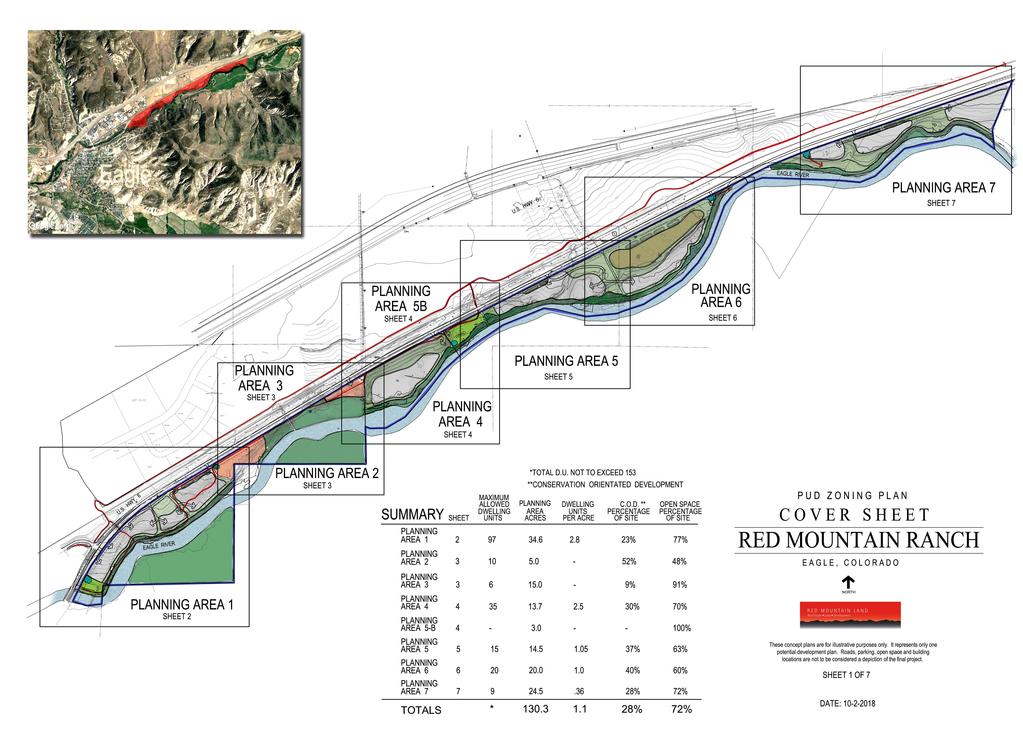
5 Red Mountain Ranch Table of Contents 1.0 Introduction Purpose of Report/Organization of Report Key Features and Findings Key Features Key Findings Project Description Existing Conditions Description of PUD Zoning Plan Planning Area Planning Area Planning Area Planning Area Planning Area 5B Planning Area Planning Area Planning Area Roads, Circulation & Traffic Utility Services Phasing Park Land Dedication School Land Dedication Fire Protection & Emergency Services Local Employee Residency Program Sustainable Design Architectural Character Water Rights Drainage Fiscal Impacts Density Transfer 36 1
6 4.0 Subdivision Sketch Plan Environmental Conditions Geology Wildlife Vegetation/Wetlands Eagle Area Community Plan Background EACP Vision EACP Land Use FLUM & Urban Growth Boundary EACP Special Character Areas EACP Remaining Chapters Town of Eagle River Corridor Plan Background & Purpose of Plan Chapter 1, Six Themes Chapter 2, Future Land Use Cluster Residential Chapter 3, Open Space & Trails River Corridor Plan Summary Summary Draft PUD Guide Appendix A B C D E F G H I Application Form and Title Reports Wildlife Report Geotech Reports Traffic Analysis Fiscal Analysis Utility Report Drainage Report Water Rights Analysis Open Space Slope Exhibit 2
7 List of Figures Figure 1 Vicinity Map 11 Figure 2 PUD Zoning Plan Cover Sheet Figure 3 Planning Area 1 PUD Zoning Plan 23 Figure 4 Planning Area 2 & 3 PUD Zoning Plan 24 Figure 5 Planning Area 4 & 5B PUD Zoning Plan 25 Figure 6 Planning Area 5 PUD Zoning Plan 26 Figure 7 Planning Area 6 PUD Zoning Plan 27 Figure 8 Planning Area 7 PUD Zoning Plan 28 Figure 9 Planning Area Summary Chart 29 Figure 10 Sketch Plan Sheet 1 40 Figure 11 Sketch Plan Sheet 2 41 Figure 12 Sketch Plan Sheet 3 42 Figure 13 Sketch Plan Sheet 4 43 Figure 14 Sketch Plan Sheet 5 44 Figure 15 Sketch Plan Sheet 6 45 Figure 16 Sketch Plan Sheet
8 1.0 INTRODUCTION 1.1 Purpose of Report The purpose of this report is to provide information relative to a request for approval of a PUD Zoning Plan, an overall Subdivision Sketch Plan and Annexation of the Red Mountain Ranch property. See Figure 1, Vicinity Map. These applications represent the initial step in the Planned Unit Development and Subdivision review process as outlined in the Town of Eagle Land Use and Development Code. The purpose of the PUD Zoning Plan level of review is to establish the permissible type, location and densities of land uses, to determine compatibility of the PUD proposal with the Town s goals, policies and plans, and to provide a basis for PUD Zoning. Formal annexation of the property will occur in conjunction with the approval of the PUD Zoning Plan The purpose of the Subdivision Sketch plan is to identify how the overall 130-acre Red Mountain Ranch property will be initially subdivided to create each described Planning Area in this application as a separate fee simple parcel. This Subdivision Sketch Plan does not include any development plan details within these parcels such as internal roads, utilities or lot and block layout. Following annexation of the property and approval of the PUD Zoning Plan and this initial Subdivision Sketch Plan, a final plat will be submitted to formally create the separate land parcels for each planning area of the PUD Zoning Plan. Each Planning Area may then proceed to and through the PUD Development Plan and subdivision process separately. Those future PUD Development Plan and subdivision stages of the development review process will provide the higher level of detail of the physical development plan, riparian and sensitive area plans, the infrastructure design and the public improvements. Applications and information included within this first stage submittal include: Application forms for PUD Zoning Plan and Subdivision Sketch Plan and a Petition for Annexation. A thorough description of the vision for the entire Red Mountain Ranch property and a written and graphic description of the permissible type, general location and densities of land uses, including a thorough description of existing conditions, an analysis of environmental site conditions and an evaluation of compliance with the Eagle Area Community Plan, the Eagle River Corridor Plan and other pertinent master planning documents. This includes a description of the interpretation and compliance with the Eagle Area Community Plan Conservation Oriented Development designation for the 4
9 Red Mountain Ranch lands and a description of the compliance with the Residential Cluster designation of the Eagle River Corridor Plan. Specifically, this report addresses all information required by Chapter 4.11 Planned Unit Development, Chapter 4.12 Subdivision Review and Chapter 4.14 Annexation, of the Town of Eagle Land Use and Development Code. 2.0 KEY FEATURES AND FINDINGS 2.1 Key Features The proposed PUD Zoning Plan for Red Mountain Ranch features: A PUD Zoning Plan that has been specifically designed to meet the goals and objectives of the Eagle Area Community Plan. A PUD Zoning Plan that has been specifically designed to meet the goals and objectives of the Town of Eagle - River Corridor Plan. A PUD Zoning Plan that details the foundation for each neighborhood to develop in a manner that meets the Conservation Oriented Development vision of the Eagle Area Community Plan and the Cluster Residential vision of the Town of Eagle- Eagle River Corridor Plan. A master planning approach that includes and allows for a wide variety of housing types that will provide home ownership opportunities to a wide range of the economic spectrum of town residents. Housing types include a wide range of size and price point market rate townhomes and condominiums and Town of Eagle deed restricted affordable housing options as well as a variety of low density single family and duplex home sites. A significant dedication of land for two Eagle River Parks that will allow for improvements and recreational uses that meets the goals of the adopted River Corridor Plan, with two connections to the ECO Trail regional bike path and existing neighborhoods. Gives the Town control of 2 miles of continuous public access to the Eagle River. A vital recreation amenity to the Town of Eagle and its Eagle River Park. An internal vehicular circulation plan with private roads and driveways that will be owned and operated by the homeowners and will not create any maintenance or operational costs to the Town of Eagle. A comprehensive and continuous pedestrian circulation system through Planning Areas 1-5B that will provide tremendous riverfront access, connect public open 5
10 space parcels, provide pedestrian access to the ECO Trail regional bike path and is in conformance with the River Corridor Plan vision and goals. A unique river front restaurant and community gathering spot opportunity that currently does not exist in the Town of Eagle. With a local farm to table and demonstration garden/ farm emphasis A plan that includes off-street public parking for parks and trail access. The existing and dangerous Highway 6 shoulder parking that serves the existing fishing access easement will be eliminated and new safer off-street public parking will be provided to serve the fishing easement. A dedication of fifteen acres to an environmental non-profit, such as the Walking Mountain Science School, will allow for a large preservation parcel on both sides of the Eagle River and the development of a future education, nature preserve and tourism attraction. Approximately eighteen acres, of high quality open space on the south side of the Eagle River that will provide an amenity and public benefit to all citizens of the Town of Eagle. An appropriate provision of deed restricted affordable housing in full compliance with the Town of Eagle Land Use and Development Code. A non-potable water system that will address the irrigation demands of the property and eliminate demand and operational costs from the existing and future Town of Eagle water treatment facilities. Extends the Town of Eagle boundary to Diamond Star Ranch. Red Mountain Ranch has already provided an easement of 1.65 miles to the Eco Trail extension in order for Eco trails to quickly receive a GOCO Grant. 2.2 Key Findings The Red Mountain Ranch Annexation request is in full compliance with Chapter 4.15, Section 010, Annexation Procedures, of the Town of Eagle Land Use and Development Code. By separating the annexation and development process, the Town of Eagle Planning and Zoning and Town Board has more control over what occurs on each Planning area. The proposed Subdivision Sketch Plan proposes a future final plat subdivision of the Red Mountain Ranch land into parcels that will match the PUD Zoning Plan Planning Areas. 6
11 The Red Mountain Ranch PUD Zoning Plan is in full compliance with the Standards and Requirements for a Planned Unit Development as outlined in Chapter 4.11 of the Town of Eagle Land Use and Development Code. Specifically, the Red Mountain Ranch plan meets each of the following standards: Town of Eagle Municipal Code Section Standards and requirements A. Minimum size The Red Mountain Ranch PUD Zoning Plan provides a land use plan for 130 acres of land. This master plan integrates residential, commercial, public, and community based uses in a comprehensive design that integrates vehicular and pedestrian circulation, parks and open space. The application meets and greatly exceeds the minimum size requirement of five acres for PUD Zoning in the Town of Eagle. B. PUD Zoning 1. Designation required The Red Mountain Ranch PUD Zoning Plan identifies each of the eight individual Planning Areas within Red Mountain Ranch as a Residential, Commercial or Public PUD. The Red Mountain Ranch PUD is in conformance with this standard. 2. Uses The allowed land uses each planning area have been specified in the proposed PUD Guide and are generally further limited beyond what the Town of Eagle PUD designation or similar standard zone district designation would allow. Any land uses proposed in planning areas that are not listed in the Town of Eagle PUD designations are noted in this PUD Guide as variations from this standard. A primary benefit and purpose of utilizing the PUD zoning is to allow for both flexible planning than is allowed with existing Town of Eagle zone designations. The Red Mountain Ranch PUD is in conformance with this standard. 3. Density The overall density of Red Mountain Ranch is 1.17 units per acre, which is well under the maximum allowance of 8 units per acre for a Residential PUD. Each individual Planning Area that is designated as a Residential PUD is restricted to density maximums well below the 8 unit per acre allowance. The two areas designated for Commercial PUD are restricted to floor area limitations well below the allowable Floor Area allowance of 1.7:1. The Red Mountain Ranch PUD is in conformance with this standard 7
12 C. Open Space The Town of Eagle PUD zoning requirement detailed in Section C of the municipal code requires 20% of the gross PUD area as open space. At 130 acres, the Red Mountain Ranch PUD would require 26 acres of open space. The proposed PUD Zoning Plan identifies over 37 acres of dedicated public open space, environmental education/preservation lands and formal park space, along with a 2 acres of river front pedestrian trail easements that will exceed this requirement. Planning Area 1 includes a 1.2 acre formal public park and 18 acres of open space land on the south side of the river that will be dedicated to the town. This land will be publicly accessible and provides open space recreation opportunities for trails and for river access. Planning Area 5B is a 3-acre park with river access that will also be dedicated to the town. Planning Area 3 is a 15-acre parcel that will be dedicated to host a nature/education facility that may include environmental education programming activities and environmental interpretation exhibits. This land use provides a significant opportunity for tourism development, community engagement and education. The open space calculation of 37 acres does not include the park and open space buffer lands that will be designed into each of the residential neighborhoods. By utilizing the Conservation Oriented Development and Cluster Residential techniques reflected in the vision of the two applicable Master Plan documents to identify general development and conservation areas within each Planning Area the overall open space percentage of the Red Mountain Ranch PUD will be approximately 72% of the 130-acre land area, equaling over 90 acres. The proposed open space includes a mix of active public (Town of Eagle dedicated) and private (HOA) parks, passive recreation areas, wetlands, preserved upland lands, an environmental education facility and an expansive pedestrian trail system. The municipal code also states that 75 % of the open space shall have a slope of 10% or less and that half of that area be developed as active recreation area. The applicant assumes this means 75% of the required minimum of 20% of the gross land area. At 75% of the required minimum of 26 acres of open space there would need to be 19.5 acres of open space at a 10% or less grade and 9.75 acres of that would need to be developed as active recreation. A review of the proposed open space areas within the PUD, including the dedicated open space lands, the preservation areas and the proposed buffer zones the project meets the minimum area of 19.5 acres of open space under 10% in grade. A set of maps indicating these calculations is included in the appendix of this report. The Red Mountain Ranch plan does not propose active recreation uses for 9.75 acres as called out in the municipal code. This section of the municipal code does not relate to proposed density, only to the overall project area. As a low density project of a maximum of 153 dwelling units 9.75 acres of active recreation seems excessive and out of place in 8
13 this location along the river. The proposed open space includes the two active recreation parks and the riverfront discovery trail, as well as meeting all of the other open space recommendations of the Eagle River Corridor Plan. While the overall open space is much higher than the required minimum and the proposed plan meets the minimum requirement for the area of open space at 10% grade the application does not meet the standard for the 9.75 acres of active recreation area and requests a variance from the active recreation area standard. D. Maintenance of Open Space Some of the open space areas will be dedicated to the Town of Eagle, some to a non-profit organization dedicated to education and preservation and some will be dedicated to neighborhood homeowner s associations. The HOA and non-profit entities will be appropriately structured and funded to allow for full ownership, care, maintenance, operation and management capabilities. These details will be fully addressed in both the PUD approval documents and in the Red Mountain Ranch Annexation Agreement. Final size, shape, design and maintenance programs will be determined at the PUD Development Plan and subdivision review plans for each Planning Area as those applications move through the review process. The Red Mountain Ranch PUD Zoning Plan is in conformance with this standard. E. Municipal and Park Land Dedication The Red Mountain Ranch PUD Zoning Plan will far exceed the Town of Eagle standards for municipal and park land dedication. Section of the land use regulations includes a formula for land dedication requirements for parks and open space. At this level of review an exact calculation of that formula is not possible nor appropriate as the exact densities and unit mix types will not be finally determined until Development Plan review. However, a general calculation based on the maximum density of 153 units and a hypothetical unit mix of 92 multi-family homes and 61 single family homes indicates that the dedication requirement would be 5.32 acres. The PUD Zoning Plan includes a dedication of Planning Area 5B as a town park of 3-acres and indicates a town park on Planning Area 1 of 1.2-acres. These areas alone account for 4.2 acres of public park. The public easement dedicated for the riverside trail as depicted in the Eagle River Corridor Plan will add to approximately 2 acres of public recreation area. In addition, each Planning Area will also include, in the PUD Development Plans to be submitted at the next stage of review, lands designated for formal parks and recreation. The Red Mountain Ranch PUD Zoning Plan is in conformance with this standard. F. PUD Perimeter 9
14 The perimeter area of the Red Mountain Ranch property has been appropriately designed to address compatibility of adjacent uses. The higher density and intensity of land uses is focused towards the existing town center and decreases to very low density residential uses as the property extends eastward. Those densities are compatible with the existing approved residential neighborhoods adjacent to the east end of Red Mountain Ranch. The riverfront area has been protected with additional enhanced setbacks and limitations on uses and vegetation management. The Highway 6 perimeter will be enhanced with landscape screening and berming where appropriate. These details will be developed as the specific PUD Development Plans are designed and reviewed. The Red Mountain Ranch PUD Zoning Plan is in conformance with this standard. G. Street Standards The PUD Zoning Plan does not anticipate any public road dedications. All internal streets and parking areas are anticipated to remain private and will be maintained by the appropriate neighborhood homeowner s association. The Town of Eagle will not be expected or required to provide any street maintenance. As the specific layout and density of each neighborhood will not be determined until a PUD Development Plan is submitted, reviewed and approved specific street design standards are not included at this level of review. Specific street design standards will be detailed as a part of future PUD Development Plans and subdivision applications for each planning area. The Red Mountain Ranch PUD Zoning Plan is in conformance with this standard at this level of review. H. Phasing The Red Mountain Ranch PUD Zoning Plan has been designed in a manner that readily facilitates a comprehensive and logical phasing plan. A proportional amount of the required open space and recreation areas will be developed with each phase of the project. The project will be built to comply with the overall density and open space requirements at the completion of each phase of development. A full description of the proposed phasing plan and land dedications is included in 3.13 in this report. The Red Mountain Ranch PUD Zoning Plan is in conformance with this standard. Key Findings Summary In summary, the Red Mountain Ranch applications are in full compliance with the annexation, subdivision and PUD requirements of the Town of Eagle Land Use and Development Code. 10

15 3.0 PROJECT DESCRIPTION 3.1 Existing Conditions Red Mountain Ranch consists of a acre property located along the Eagle River just east of the Town of Eagle downtown core area. The western boundary of the property starts at the first Highway 6 bridge crossing of the Eagle River east of town and extends east approximately 2.05 miles. The property is generally located between the Eagle River and Highway 6, with some land extending south of the river. The property is currently held in two separate ownerships. The Mervyn Lapin Revocable Trust owns the westernmost lands, identified in this application as Planning Areas 1 and 2. The land identified in this application as Planning Areas 3 through 7 is owned by the Red Mountain Ranch Partnership, Ltd. The two ownerships have some common elements and are managed by a single entity. For the purpose of this application the term Red Mountain Ranch is used as the project name and refers to the title of the proposed Planned Unit Development inclusive of Planning Areas 1 through 7. The property includes high terrace upland areas adjacent to Highway 6 and a wetland and riparian complex along the stream frontage. Several sections of the upland terrace have been mined for gravel and placed in reclamation. There is one occupied home located on Planning Area 2. All the upland areas have been disturbed in some manner, either by gravel mining or agricultural practices. Portions of the property have been flood irrigated for agricultural uses and there are several irrigation ditches that traverse the property. There are currently eleven residential, gravel pit and ranch access points from Highway 6 that provide access to various portions of the property. The property is currently located outside the Town of Eagle boundary and is proposed for annexation to the Town of Eagle. The adjacent lands across Highway 6 to the north have been annexed to the town as a part of the Eagle River Station PUD. There is a low density residential neighborhood of one to two acre lots just beyond the eastern boundary of the property. The property falls within the study area of the Eagle Area Community Plan and the Town of Eagle - River Corridor Plan. 11
16 3.2 Description of the PUD Zoning Plan This application package proposes to annex the Red Mountain Ranch property to the Town of Eagle as a PUD Zoning Plan Planned Unit Development. The purpose of the PUD Zoning Plan, as outlined in the Town of Eagle Land Use Regulations, shall be to establish permissible type, location, and densities of land uses, to determine compatibility of the PUD proposal with the Town s goals, policies, and plans, and with the purposes of this chapter, and to provide a basis for PUD zoning. The proposed PUD Zoning Plan map identifies the proposed land use types, general locations and maximum proposed densities. This narrative will describe the plan s compatibility with the Town s goals, policies and plans. Together with the proposed PUD Guide, the PUD Zoning Plan maps and this narrative will comprise the PUD Zoning Plan for Red Mountain Ranch. The specific arrangement of buildings, lots, roads and parking lots will be detailed as each Planning Area is brought through the next step of the planning process, the detailed PUD Development Plan review. The Red Mountain Ranch property is currently contiguous to but outside of the Town of Eagle municipal growth boundary and, except for Planning Areas 6 & 7, within the Urban Growth Boundary defined within the Eagle Area Community Plan. The Red Mountain Ranch property represents one of the last large development parcels that may be annexed into the Town of Eagle. The property, given its prominent location along the Eagle River and its proximity to downtown Eagle and the Eagle River Station property, is a key element in the future growth and development of the Town of Eagle. By providing a comprehensive concept plan for the entire 130-acre river property owned by Red Mountain Ranch, including Planning Areas 6 & 7, the plan is able to address growth related impacts in a meaningful way and is able to provide significant community assets that are much more difficult, in fact, perhaps impossible to accomplish with the incremental growth that occurs from smaller development projects. Through the inclusion of a public riverfront park, preservation of open space, improved public fishing access and parking, and the design of a comprehensive and integrated trails system Red Mountain Ranch will make a very special contribution to the community fabric of the Town of Eagle. These design elements are possible by integrating the two ownership entities into one comprehensive development plan for the entire property through the PUD Zoning process. The PUD Zoning plan evolved out of a careful analysis of many factors, including the Eagle Area Community Plan, the Town of Eagle River Corridor Plan, adjacent growth and land use patterns, anticipated long term residential housing needs, desired recreational amenities, and the land forms and environmental sensitivities of the site with feedback from past staff s and trustees. 12
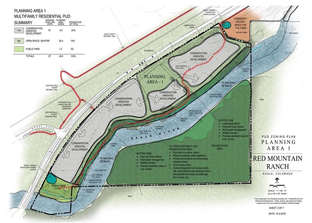
17 The primary elements of the design influences listed in the above paragraph are the 2010 Eagle Area Community Plan and the 2016 Town of Eagle River Corridor Plan. The Eagle Area Community Plan chapters on Vision, Land Use and the Conservation Oriented Development section of Chapter 4 provide direction to the overall plan and the distribution of densities. The River Corridor Plan gives very specific direction to the development of the Red Mountain Ranch property and addresses land use types, density, public parks, open space and trails. The proposed zoning plan has been designed to the goals and policies of these two guiding documents. The plan is based around decreasing residential density as the property extends to the east and includes a network of open space, park and trail corridors that creates an organized layout of neighborhoods, community uses and public parks while conserving significant amounts of open space and protecting significant natural features of the site. An extensive trail system provides a significant public benefit and connects the community to the river and to the public river park. The Red Mountain Ranch plan proposes a maximum of 153 units on 130 acres of land for a very low overall density of 1.17 units per acre. The plan proposes a mix of multi-family and single family and/or duplex units. Some of the Planning Areas will allow for flexibility in the mix of unit types. Most of the multi-family density is designated for the first phase of development, on Planning Area 1, closest to the community core. This area, in conformance with both the EACP and the River Corridor Plan, includes the highest density with a total of 97 of the overall 153 units, which due to clustering and a significant area of open space conservation, is still relatively low at an average of 2.8 units per acre. The decreasing density culminates in Planning Area 7, a single-family neighborhood of nine homes on twenty-four and a half acres, for a density of 0.36 units per acre (2.7-acre average per unit). The soft surface path, 12 feet wide running through Planning Areas 1-5B, will provide approximately 2 acres of recreational open space. An important concept of the PUD Zoning Plan is the maximum overall density of 153 dwelling units. This overall density for the property is consistent with the direction of the Eagle River Corridor Plan. The proposed plan includes an ability to shift these units among the different planning areas, to some degree, with the maximum density per planning area as indicated on the PUD Zoning Plan Cover Sheet-Sheet 1 of the PUD Zoning Plan and as described in this report. 3.3 Planning Area 1 Residential PUD Planning Area 1 is the westernmost area within Red Mountain Ranch and is the largest individual planning area. The western edge of the planning area is adjacent to the bridge crossing (formerly known as the Green Bridge) of the Eagle River and includes approximately 35 acres on both sides of the Eagle River. As the largest planning area and the closest to town this area would host the highest density of Red Mountain Ranch. As called out in both the Eagle Area Community Plan and the River Corridor Plan the 13
18 proposed density is in keeping with the Conservation Oriented Development and the River Corridor Plan Cluster Residential land use designations. At a maximum density of 97 units and an overall size of 34.6 acres the 2.8 units per acre is well below the Town of Eagle Residential PUD maximum allowance of 8 units per acre. The intent of the PUD Zoning Plan level of review, as stated in the Town of Eagle Municipal Code is to establish the permissible type, location and densities of land uses, to determine compatibility of the PUD proposal with the Town s goals, policies and plans and to provide a basis for the zoning. The intent of the PUD Zoning Plan maps is to give some general form to the type and location of land uses and to determine appropriate densities of those proposed land uses. Determining the general locations of development areas and of open space or buffer areas allows the plan to be shaped, at this level of review, by the concepts of the EACP and the River Corridor Plan. The more detailed and engineered design of the subsequent PUD Development Plan will present a more specific and detailed location of the proposed residential uses, the open space areas, and the trails and amenities. The westernmost portion of Planning Area 1 would be an approximately 1.2-acre public park and public parking featuring a public riverfront trail. This park would be connected to both the town core area and to Red Mountain Ranch via the pedestrian trail identified in the Town of Eagle - River Corridor Plan. A small number of public parking spaces would be provided to serve the park and to provide fishing and trail access along the river. The PUD Zoning Plan has been designed to meet the concepts of Conservation Oriented Development and the Residential Cluster description of the River Corridor Plan. The plan provides for clustered areas of development and indicates where open space or recreation area buffers should be integrated into the overall site plan. The future Development Permit Plans should respect this concept and should follow the general locations of the development lands and the buffer areas. These buffer areas may be natural open space, such as the foot river corridor preservation area, or may be designed as improved passive or active open space and recreation areas. Density should transition to lower unit per acre building types and site plans as the development ranges from west to east. In order to provide for a range of unit types and price points density could range from up to ten units per acre at the west end and transition to lower densities fronting the river. A transition to duplex and/or single family layout of approximately three to four units per acre or less would be appropriate at the east end. The overall PUD Development Plan for Planning Area 1 should include one or more improved parks that that total approximately 1.2 acres. At a hypothetical unit mix of 55 multi-family units and 20 single family the Town of Eagle park land dedication would equate to 2.49 acres. The 1.2-acre public park dedication, the additional integrated parks of at least one acre and the public trail corridor along the river 14
19 will more than meet this standard. The final park size requirements will be determined at PUD Development Plan design. The public riverfront pedestrian trail would extend from the western public park along the river as a twelve-foot-wide public easement along the riverfront. The trail would swing away from the river to provide a break along the river corridor. The trail will then continue east across Planning Area 1 and into Planning Area 2. A forty-foot-wide open space/drainage corridor indicated on the plan would allow for the trail to connect from the river corridor to a separated grade crossing at Highway 6. The separated grade crossing will connect to the existing Eagle County ECO Trail located on the north side of Highway 6. Appropriately designed community open space will separate and define each neighborhood area and create useable open space and park areas all connected by a pedestrian trail system. Overall, the intent is for Planning Area 1 to become a walkable neighborhood that includes multiple areas to access the riverfront, relax, recreate and socialize. A detailed PUD Development Permit plan review and approval will be required prior to any development proceeding on site. This review process will provide the Town and community members a detailed review process to ensure conformance with the PUD Zoning Plan and with the governing master plans and land use regulations. The density type and layout may vary in the PUD Development Plan but shall not exceed 97 units. All of the land located on the south side of the Eagle River, approximately 18 acres, will be committed to open space. This area, along with the soft surface trail corridor on the north side of the river is identified as Open Space Area #5 in the River Corridor Plan. This open space area and trail corridor creates a significant amount of public river access that was formerly private and is in complete conformance with the River Corridor Plan. This open space south of the river will be dedicated at the time of Planning Area 1 PUD Development receipt of Building Permit. As proposed approximately 70% of the planning area will be open space, in conformance with the concepts of Conservation Oriented Development and the Residential Cluster land use. Planning Area 1 can be served by the Town of Eagle water and wastewater systems. All of the proposed uses listed in the PUD Guide for Planning Area 1 are allowed under the R/PUD uses listed in the town of Eagle Land Use Regulations. There are no listed allowed uses that are not allowed under the Town of Eagle R/PUD designation. Planning Area 1 will have two access points from Highway 6 and a privately maintained road that will include public access to public parking spaces that will provide access to the Eagle River and the Town park. The Town park and river access are significant public benefits. It is anticipated that the internal circulation and parking will be private and that there will be no publicly dedicated streets or Town of Eagle street maintenance requirements. 15
20 See PUD Zoning Plan Planning Area Planning Area 2 Commercial PUD Planning Area 2 is an approximately five-acre area that is called The Farm and includes a historic farm homestead from the early 1900 s. The intent of this planning area is to allow for the development of a neighborhood center, allowing for small scale commercial development that supports the neighborhoods and provides the greater Eagle community with a riverfront commercial opportunity and community gathering space and pavilion that does not currently exist. Thoughtful historically inspired design will be oriented towards Red Mountain and the Eagle River with a small cluster of one and two story buildings centered around terraced gardens and a greenhouse with small scale agricultural production and product sales. Potential uses include a demonstration farm/garden, farmers market, recreation river access for kayakers and tubers, a river oriented restaurant with an expansive porch and patio area and a small amount of short term lodging. The proposed density would allow for up to ten dwelling units. The Discovery trail extends from Planning Area 1 into Planning Area 2 and is shown above the river corridor to avoid a small piece of BLM land that extends onto the north shore of the river. The proposed development area for Planning Area 2 is approximately 2.6 acres. Approximately 74% of Planning Area 2 is proposed to be designated as edible landscaping gardens, open space and buffer. The proposed uses listed in the PUD Guide for Planning Area 2 do not include all the uses allowed under the C/PUD designation in the land use code. Many of these uses would not be appropriate for Planning Area 2. The list of proposed allowed uses is much more restrictive that the Eagle town code. Planning Area 2 is a mixed-use plan of commercial, residential and farm uses. The planned uses that are not specified in the Town of Eagle C/PUD designation have been listed as allowed in the PUD Guide for Planning Area 2. Commercial floor area will be restricted as listed in the PUD Guide. The amount of commercial floor area that would be allowed under the Town of Eagle C/PUD designation for floor area ratio would not be appropriate. Planning Area 2 can be served by the Town of Eagle water and wastewater systems. Planning Area 2 would be accessed via a street connection with Planning Area 1 and would not have a direct access connection to Highway 6. The density and floor area proposed for Planning Area 2 are well under the C/PUD designation allowances of the town code and the commercial uses allowed under the C/PUD designation have been strictly limited by the proposed PUD Guide. 16
21 See PUD Zoning Plan Planning Area Planning Area 3 Commercial PUD Planning Area 3 is a total of 15 acres and includes approximately 7.5 acres on the north side of the Eagle River and 7.5 acres on the south side of the river. This area is designated as Open Space Area #6 in the Eagle River Corridor Plan. The land use proposed for Planning Area 3 will be focused on environmental stewardship, preserving sensitive areas and is intended to host a nature/education facility that may include environmental education programming activities and environmental interpretation exhibits. This land use provides a significant opportunity for tourism development, community engagement and education. Examples of educational programs that could be offered include: Curriculum aligned Field Science programs for students at Brush Creek Elementary, Eagle Valley Elementary and Middle Schools and other adjacent schools. These full day science programs take place out of doors, in a hands-on manner and align with standards and units of study taught in the classroom. Topics at this location could include: aquatic biology, animal habitats, riparian health and water quality, etc. Naturalist led interpretive hikes. Naturalists help connect visitors to important natural, cultural and historical resources by forging emotional and intellectual connections between the interest of the audience and the meanings inherent in the resource. Naturalists could be paid interns or volunteer docents from the community. Volunteers with proper training can be highly capable docents. Self-Guided interpretive trail. This location lends itself well to a path or board walk with signage or other interpretive elements. These trails can be used at any time by locals or visitors and allow for individual or group exploration at any time. A soft path system of trails will provide pedestrian access throughout the site with potential to include a pedestrian bridge over the river to access the 7.5 acres of open space, the existing town trail system and BLM lands north of the river. The proposed development area is indicated on the PUD Zoning Plan and is approximately 1.3 acres in size. This area would be allowed to include a nature/education center building and associated residences. Six dwelling units have been assigned to this area and if used would be deed restricted to workforce housing for the entity operating the environmental education programs. Approximately 91% of the site area is designated as open space/conservation/preservation area. This is consistent with the Conservation Oriented Development and Cluster residential land use concepts expressed in the EACP and the River Corridor Plan and is a significant public benefit. The pedestrian trail would continue from Planning Area 2 into Planning Area 3. The trail is shown on the upland portion of Planning Area 3 due to the high environmental sensitivity and extensive wetlands located along the river. 17
22 The Planning Area has been assigned a Commercial PUD designation because the existing Town of Eagle Land Use regulations do not include a PUD designation that encompasses the proposed educational/conservation/open space uses. The PUD Guide list of uses for Planning Area 3 has been tailored to meet the goals of the River Corridor Plan and to allow for an educational/environmental program. These uses are not generally listed as uses in the C/PUD. Almost all the allowable uses under the Town of Eagle C/PUD designation are restricted from the planning area as they would certainly not be appropriate in this location. Commercial floor area will be restricted as listed in the PUD Guide. The amount of commercial floor area that would be allowed under the Town of Eagle C/PUD designation would not be appropriate. The existing town PUD designations do not work well with this concept of land use; however, the PUD process is intended to allow for this type of creativity and flexibility. Planning Area 3 would have direct access from Highway 6 and would include a parking area that will accommodate the proposed uses. See PUD Zoning Plan Planning Area Planning Area 4 Residential PUD. Planning Area 4 is a 13.7 acre reclaimed gravel mine area that sits 40 feet below Highway 6 and is proposed for residential homes at a maximum density of 35 dwelling units. The overall density proposed is approximately 2.5 homes per acre. This is consistent with the Conservation Oriented Development and Cluster Residential land use concepts expressed in the EACP and the River Corridor Plan. At a maximum of 35 units the maximum park dedication for this area would be 1.47 acres. The PUD Development Plan will designate the appropriate amount of area and location for a neighborhood park. The soft surface discovery trail will extend from Planning Area 3 and will follow the river corridor east through Planning Area 4 and connect to the Eagle River Park on Planning Area 5B. All the proposed uses listed in the PUD Guide for Planning Area 4 are allowed under the R/PUD uses listed in the Town of Eagle Land Use Regulations. It is anticipated that this will be the last planning area to be developed and will be dependent on the availability of municipal water and sewer. Planning Area 4 will be accessed from Highway 6 via a privately maintained road. See PUD Zoning Plan Planning Area 4. 18
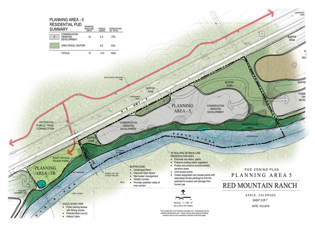
23 3.7 Planning Area 5B, Eagle River Park Public PUD. Planning Area 5B is a relatively flat pasture of 3 acres and will be dedicated to the Town of Eagle as a public riverfront park. The River Corridor Plan identifies this area as Open Space Area # 7 and calls for vehicular access, a public boat ramp and active daytime recreation uses. There is a historic cabin on the site. The soft surface discovery trail will connect all the way from Planning Area 1 to this public park. There is opportunity for a pedestrian connection to the existing, newly constructed ECO-Trail north of Highway 6. The dedication of this land to the Town of Eagle is a significant public benefit that would not be possible if the entire Red Mountain Ranch PUD was not being master planned and zoned in this comprehensive manner. The intent of the phasing plan is to dedicate Planning Area 5B at the time of Development Permit approval for Planning Area 5 and 6. Planning Area 5B would share a Highway 6 access point with Planning Area 4 that will include public access to three parking spaces that will provide access to the Colorado Parks and Wildlife fishing easement that is in place along this stretch of river front. The relocation of these parking spaces off the shoulder of Highway 6 is a significant safety improvement and a public benefit associated with this area. See PUD Zoning Plan Planning Area 5B, Eagle River Park. 3.8 Planning Area 5 Residential PUD. Planning Area 5 consists of 14.5 acres and is proposed for clustered low density residential home sites surrounded by common open space and with a common park area. The proposed maximum density of 15 units equates to an average of 1.03 units per acre. This is similar to existing land uses further to the east and consistent with the Conservation Oriented Development and Cluster Residential land use concepts expressed in the EACP and the River Corridor Plan. The Town of Eagle R/PUD list of allowable uses will be restricted to single family and duplex. Planning Area 5 will be accessed from Highway 6 via a privately maintained road. There is a potential to connect Planning Area 5 and Planning Area 6 with the internal road system. See PUD Zoning Plan Planning Area Planning Area 6 - Residential PUD Planning Area 6 includes approximately 20 acres and is proposed for low density single family and duplex homes at a maximum density of 20 homes. This equates to a density of 1 unit per acre. This is similar to existing land uses further to the east and is consistent 19
24 with the Conservation Oriented Development and Cluster Residential land use concepts expressed in the EACP and the River Corridor Plan. The PUD Zoning Plan indicates a primary development area of 3.4 acres on a lower bench of land that has low visibility from Highway 6 and a potential future development area of 4.7 acres on the upper bench level visible from Highway 6. The Eagle River Station plans currently indicate a roundabout intersection on Highway 6 that would be adjacent to Planning Area 6. This roundabout would potentially impact the land area and grade of some of this private land and would significantly change the character of this land and planning area. The concept for the future development area is that this land may become an appropriate location for some of the residential development or for other future development if and when the character of the area changes with the construction of a major road intersection/roundabout from Eagle River Station. The primary development area consists of approximately 3.4 acres, 17 % of the site. The potential future development area includes approximately 5.7 acres, 23% of the site. The open space/buffer areas cover over 60 % of the Planning Area, remaining consistent with the Conservation Oriented Development and Cluster Residential land use concepts expressed in the EACP and the River Corridor Plan. Planning Area 6 will be accessed from Highway 6 via a privately maintained road that will include public access to three parking spaces that will provide access to the Colorado Parks and Wildlife fishing easement that is in place along this stretch of river front. The relocation of these parking spaces off the shoulder of Highway 6 is a significant safety improvement and a public benefit associated with this area. The Town of Eagle R/PUD list of allowable uses will be restricted to single family and duplex. See PUD Zoning Plan Planning Area Planning Area 7 - Residential PUD Planning Area 7 includes approximately 24.5 acres and is proposed for low density single family homes at a maximum density of 9 homes. This equates to a very low average density of 0.36 units per acre (2.7 acres per unit) and is consistent with the Conservation Oriented Development and Cluster Residential land use concepts expressed in the EACP and the River Corridor Plan. Planning Area 7 will be accessed from Highway 6 via a privately maintained road that will include public access to a public parking area of two to three spaces that will provide access to the Colorado Parks and Wildlife fishing easement that is in place along this stretch of river front. The relocation of these parking spaces off the shoulder of Highway 6 is a significant safety improvement and a public benefit associated with this area. 20
25 The Town of Eagle R/PUD list of allowable uses will be restricted to single family. See PUD Zoning Plan Planning Area 7. 21
26
27

28

29
30

31

32
33 29
34 3.11 Roads and Circulation/Traffic The Red Mountain Ranch PUD is a long linear property located along the south side of Highway 6 and bordering the Eagle River. The only access point from the public road system is from US Highway 6. There are currently eleven access drives from Highway 6 onto the Red Mountain Ranch lands. The proposed access plan consolidates these into seven access locations. All internal circulation will be designed as private streets or parking lots. Other than the Eagle River Park, which will be owned by the Town of Eagle, there are no anticipated public roads and no anticipated Town of Eagle requirements for street or parking area maintenance. The design of the internal road systems will occur at the Development Permit stage for each Planning Area. An initial trip generation analysis for Planning Areas 1 and 2 (The Farm) has been completed by LSC Transportation Consultants, Inc. and is included in the appendix of this report. The plan for this first phase of Red Mountain Ranch includes two access points from Highway 6, one aligning with the Nogal Road intersection and one at the eastern end of Planning Area 1. Planning Area 2 will connect internally to Planning Area 1 and share the two access points. The trip generation analysis indicates that right turn deceleration improvements will be required for Planning Areas 1 and 2. The PUD Zoning plan anticipates that Planning Areas 4 and 5B will share a single access point and Planning Areas 3, 5, 6 and 7 will each have their own single point of access from Highway 6. Red Mountain Ranch is currently working with CDOT on an access master plan that will provide direction to the number and location of the proposed access points. As a referral agency to the Town of Eagle the applicant will continue to work with CDOT to finalize an access master plan. As each individual planning area progresses through the PUD Development Permit application using the access master plan, a detailed traffic analysis and engineered design plans will be required as a part of the review process. No new access points or change in access use will be allowed until a CDOT Access Permit has been issued Utility Services Alpine Engineering, Inc. has completed a Utility Impact Report for the Red Mountain Ranch PUD Zoning plan. This report describes the water, sanitary sewer and shallow utility connection plans for the property. Electric and communication utilities are available within the Highway 6 right of way along the length of Planning Areas 1 and 2 and may be extended to serve Planning Areas 3 30
PUD GUIDE FOR THE RED MOUNTAIN RANCH PLANNED UNIT DEVELOPMENT
 PUD GUIDE FOR THE RED MOUNTAIN RANCH PLANNED UNIT DEVELOPMENT Exhibit B to the Annexation and Development Agreement October 15, 2018 *Notes in red are intended for Town of Eagle review purposes and are
Gold Line Bus Rapid Transit Transit Oriented Development (BRTOD) Helmo Station Area Plan
 Helmo Station Area Plan") Appendix F Gold Line Bus Rapid Transit Transit Oriented Development (BRTOD) Helmo Station Area Plan Introduction and Purpose of the Plan The Gold Line Bus Rapid Transit facility is an eleven-mile dedicated
Appendix F Gold Line Bus Rapid Transit Transit Oriented Development (BRTOD) Helmo Station Area Plan Introduction and Purpose of the Plan The Gold Line Bus Rapid Transit facility is an eleven-mile dedicated
The following principles guide the development of goals and strategies to protect and promote these amenities:
 OPEN SPACE/PARKS/TRAILS/RECREATION GOALS/STRATEGIES Cherry Hills Village is a living environment that offers low density development, open areas, public scenic vistas, public trails and public parks. This
CHAPTER 7: Transportation, Mobility and Circulation
 AGLE AREA COMMUNITY Plan CHAPTER 7 CHAPTER 7: Transportation, Mobility and Circulation Transportation, Mobility and Circulation The purpose of the Transportation, Mobility and Circulation Chapter is to
General Location Annex, Rezone & Preliminary Plat Lansdowne Addition, Unit Three
 NEWFOUNDLAND I-5 Agricultural District Subject Site SUNDANCE ANDERSON Single Family Residential CHRISTY PUD Agricultural District Highway Business General Location Annex, Rezone & Preliminary Plat Lansdowne
Applicant Name Phone / Fax / Address City State Zip Code . Property Owner Phone / Fax / Address City State Zip Code
 Master Development Plan Application Community Development Department City of Redmond 411 SW 9 th Street Redmond, Oregon 97756 541-923-7721 541-548-0706 FAX Master Development Plan Fee $38,862.52 File Number
Illustration of Eastlake Farmer s Cooperative Grain Elevator. Chapter 5: implementation 5-1
 Illustration of Eastlake Farmer s Cooperative Grain Elevator Chapter 5: implementation 5-1 chapter 5: implementation Introduction The Eastlake Subarea Plan includes a wide range of recommendations intended
PUBLIC ENGAGEMENT & SIX THEMES OF THE PLAN
 Connecting the heart of Eagle to the soul of the river - Kathy Chandler-Henry, Commissioner Eagle County CHAPTER 1 PUBLIC ENGAGEMENT & SIX THEMES OF THE PLAN town of eagle - river corridor plan 1 PUBLIC
3. VISION AND GOALS. Vision Statement. Goals, Objectives and Policies
 Vision Statement Queen Creek s interconnected network of parks, trails, open spaces and recreation opportunities provide safe and diverse activities and programs that sustain its unique, small town, equestrian
Improve Neighborhood Design and Reduce Non Point Source Water Pollution
 HOW TO Planning Guide Improve Neighborhood Design and Reduce Non Point Source Water Pollution This document was funded by a grant from the New Hampshire Coastal Program with funding from the National Oceanic
Ten Mile Creek Planning Area
 PLANNING AREA POLICIES TEN MILE CREEK Ten Mile Creek Planning Area Location and Context The Ten Mile Creek Planning Area ( Ten Mile Creek area ) is located south of the current Boise AOCI, generally south
CHUGIAK-EAGLE RIVER SITE-SPECIFIC LAND USE PLAN
 CHUGIAK-EAGLE RIVER SITE-SPECIFIC LAND USE PLAN JUNE 2010 Final Prepared for The Heritage Land Bank, Municipality of Anchorage by Agnew: :Beck Consulting www.agnewbeck.com 907.222.5424 Chugiak-Eagle River
North Oakville East Parks Facilities Distribution Plan. November, 2009
 North Oakville East November, 2009 POLICY CONTEXT 1) Purpose a) The purpose of this document is to be a guide for the location, configuration, design and development of the parks system for the North Oakville
7.0 OPEN SPACE 7.1 OPEN SPACE DEDICATION CHAPTER 7: OPEN SPACE
 7.0 OPEN SPACE The intent of these requirements is to allow for the usage of centrally located unencumbered land as neighborhood open spaces and not to permit the use of leftover or otherwise unusable
Mitchell Ranch South MPUD Application for Master Planned Unit Development Approval Project Narrative. Introduction
 Mitchell Ranch South MPUD Application for Master Planned Unit Development Approval Project Narrative Introduction Mitchell Ranch South is a proposed single family (detached) residential development on
Eastcreek Farm. Planned Development Standards September, 2014
 Eastcreek Farm Planned Development Standards September, 2014 ekfarm Contents 01. General Standards 02. Residential Development Standards 03. Architectural Design Standards 04. Landscape Design Standards
BYLAW C A Bylaw of Rocky View County to amend Land Use Bylaw C
 BYLAW C-7720-2017 A Bylaw of Rocky View County to amend Land Use Bylaw C-4841-97. The Council of Rocky View County enacts as follows: PART 1 TITLE This Bylaw shall be known as Bylaw C-7720-2017. PART 2
GENERAL LAND USE PLAN ELEMENT
 CITY OF Prepared by City of Medford Planning Department 200 South Ivy Street Medford, Oregon 97501 plnmed@ci.medford.or.us James E. Huber, AICP, Planning Director COMPREHENSIVE PLANNING SECTION John Adam,
SECTION 6 - LAND USE - RURAL RESIDENTIAL
 16.6.10.1 Intent The intent of the rural residential land use category is to provide low-density, single-family residential development within the Town s outer fringe. The current land is predominantly
Mendota Heights 2040 Comprehensive Plan Draft Vers
 4 Parks and Trails The City of Mendota Heights boasts a variety of recreational and open space opportunities. Few cities can claim access to regional trails, riverside and lakeside parks, scenic bluffs
SPECIFIC PLAN Requirements
 CITY OF LANCASTER PLANNING DEPARTMENT 44933 Fern Avenue, Lancaster, California 93534 (661) 723-6100 SPECIFIC PLAN Requirements Purpose The purpose of a specific plan is to provide for the logical development
EXHIBIT B PROJECT NARRATIVE POULSBO MEADOWS
 EXHIBIT B PROJECT NARRATIVE POULSBO MEADOWS Name of Project: Poulsbo Meadows; A Planned Residential Development (PRD)/Plat Applicants Name: PBH Group LLC/Byron Harris PO Box 1010 Silverdale, WA 98038 Description
LAND USE ELEMENT. Purpose. General Goals & Policies
 LAND USE ELEMENT Purpose This Land Use Element contains the goals and policies necessary to support the City s responsibility for managing land resources and guiding development through implementing regulations,
REQUEST Current Zoning: O-15(CD) (office) Proposed Zoning: TOD-M(CD) (transit oriented development mixed-use, conditional)
 (office) Proposed Zoning: TOD-M(CD) (transit oriented development mixed-use, conditional)") Rezoning Petition 2016-117 Zoning Committee Recommendation January 4, 2017 REQUEST Current Zoning: O-15(CD) (office) Proposed Zoning: TOD-M(CD) (transit oriented development mixed-use, conditional) LOCATION
Rezoning Petition 2016-117 Zoning Committee Recommendation January 4, 2017 REQUEST Current Zoning: O-15(CD) (office) Proposed Zoning: TOD-M(CD) (transit oriented development mixed-use, conditional) LOCATION
Policies and Code Intent Sections Related to Town Center
 Policies and Code Intent Sections Related to Town Center The Town Center Vision is scattered throughout the Comprehensive Plan, development code and the 1994 Town Center Plan. What follows are sections
City of Fort Lupton Administrative Site Plan Process
 City of Fort Lupton Administrative Site Plan Process Purpose The Site Plan process is meant to promote orderly and sound development standards as they apply to the City. These site development standards
Parks, Open Space and Trails
 Introduction Parks have often been referred as the lungs of our cities, cleansing the air of pollutants and particulate matter. Parks are also gathering places for families and community. They offer spaces
6 COMMUNITY SERVICES AND FACILITIES
 6 COMMUNITY SERVICES AND FACILITIES 6.1 PARKS AND OPEN SPACE The Hecker Pass Specific Plan provides over 98 acres of public parks and open space as shown in Figure 6-1. The bulk of this acreage is located
ARTICLE 6: Special and Planned Development Districts
 ARTICLE 6: Special and Planned Development Districts 6-10 Traditional Neighborhood Development (TND) District 6-10.10 Purpose and Intent The Traditional Neighborhood Development (TND) District provides
CITY PLANNING COMMISSION AGENDA ITEM: C STAFF: ROBERT TEGLER FILE NO: CPC PUD QUASI-JUDICIAL
 CPC AGENDA June 8, 2006 Page 37 CITY PLANNING COMMISSION AGENDA ITEM: C STAFF: ROBERT TEGLER FILE NO: CPC PUD 05-294 - QUASI-JUDICIAL PROJECT: APPLICANT: OWNER: PARKWOOD AT WOLF RANCH NASS DESIGN ASSOCIATES
Major Subdivision Sketch Plan Checklist
 This checklist provides specific requirements that are apart of the Sketch process. The entire process is described by the Huntersville Subdivision Review Process which details all the submittal and resubmittal
CITY OF ANN ARBOR MASTER PLAN. Land Use Element
 CTY OF ANN ARBOR MASTER PLAN Land Use Element June 15, 2009 Prepared by the Ann Arbor City Planning and Development Services Unit and the City of Ann Arbor Planning Commission City Master Plan: Land Use
Small Area Plan. South Gateway
 Small Area Plan Adopted May 12, 2008 South Gateway Purpose. The South Gateway Small Area Plan defines the City s expectations for the future of the southern entrance to the City at Interstate 85 and Highway
PORT WHITBY COMMUNITY
 PORT WHITBY COMMUNITY SECONDARY PLAN UPDATE COMMUNITY IMPROVEMENT PLAN URBAN DESIGN GUIDELINES September 2015 DRAFT PROPOSED AMENDMENT NUMBER # to the Whitby Official Plan PURPOSE: The intent of this Amendment
SYRINGA VALLEY SPECIFIC PLAN NARRATIVE
 SYRINGA VALLEY SPECIFIC PLAN NARRATIVE Introduction With this application, Pleasant Valley South LLC ( Pleasant Valley ) seeks the City of Boise s approval of a new Specific Plan Ordinance to be added
DRAFT Amsterdam/Churchill Community Plan (4/17/08) Adopted By the Gallatin County Commission
 Adopted By the Gallatin County Commission") DRAFT Amsterdam/Churchill Community Plan (4/17/08) Adopted By the Gallatin County Commission Table of Contents Acknowledgements Chapter 1: Introduction A Brief History What s Next Authority Organization
DRAFT Amsterdam/Churchill Community Plan (4/17/08) Adopted By the Gallatin County Commission Table of Contents Acknowledgements Chapter 1: Introduction A Brief History What s Next Authority Organization
Appendix C: Interim Mixed-Use Evaluation Criteria
 Appendix C: Interim Mixed-Use Evaluation Criteria C-1 Appendix C: Interim Mixed-Use Evaluation Criteria PURPOSE: The implementation of numerous policies contained within the Master Plan hinges on the creation
Staff Report to the North Ogden City Planning Commission
 Staff Report to the North Ogden City Planning Commission SYNOPSIS / APPLICATION INFORMATION Application Request: Concept review on a legislative application to rezone land located at approximately 1750
AWH REPORT OF THE PLANNING AND DEVELOPMENT DEPARTMENT FOR APPLICATION FOR REZONING ORDINANCE TO PLANNED UNIT DEVELOPMENT
 AWH REPORT OF THE PLANNING AND DEVELOPMENT DEPARTMENT FOR APPLICATION FOR REZONING ORDINANCE TO PLANNED UNIT DEVELOPMENT MAY 8, 2014 The Planning and Development Department hereby forwards to the Planning
Lehigh Acres Land Development Regulations Community Planning Project
 Lehigh Acres Land Development Regulations Planning Effort Summary In July, 2010 Commissioner Frank Mann invited the Lehigh Acres community to start discussing how to achieve their recently adopted community
AREASTRUCTURE PLAN AMENDMENT COCHRANE NORTH
 AREASTRUCTURE PLAN AMENDMENT COCHRANE NORTH In order to implement the vision outlined in the Conceptual Scheme, the following three amendments to the Cochrane North ASP are proposed: 1. Allow commercial
3.1 community vision. 3.3 required plan elements
 Chapter 3 Community Form 3.1 community vision 3.2 Parks & landscaping concepts 3.3 required plan elements D R A F T 20 Community Form Chapter 3 3.0 Community form 3.1 community vision The Specific Plan
Bourne Downtown Site Planning
 Prepared for: The Town of Bourne, MA In Cooperation with: Bourne Financial Development Corporation Prepared by:, Inc. June 24, 2009 Table of Contents Introduction and Summary... 1 Site Existing Conditions...
The petition proposes the development of five townhomes on a vacant parcel between Charlotte Latin School and Providence Presbyterian Church.
 Rezoning Petition 2017-202 Final Staff Analysis June 18, 2018 REQUEST LOCATION Current Zoning: R-3 (single family residential) Proposed Zoning: UR-2(CD) (urban residential, conditional) with five-year
Municipal Development Plan. Summer Village of ROCHON SANDS. Bylaw #241-18
 Municipal Development Plan Summer Village of ROCHON SANDS Bylaw #241-18 TABLE OF CONTENTS PART ONE: BACKGROUND AND PURPOSE 3 SECTION 1: BACKGROUND 3 SECTION 2: GOALS AND POLICIES 3 PART TWO: PHYSICAL ENVIRONMENT
CHAPTER FIVE COMMUNITY DESIGN
 CHAPTER FIVE COMMUNITY DESIGN CHAPTER FIVE - COMMUNITY DESIGN Assumptions Frazier Park and Lebec have historically developed according to different patterns of spatial form. While both communities are
CHAPTER 22 Rural Open Space Community Developments
 CHAPTER 22 Rural Open Space Community Developments Section 22.1 Description and Purpose The intent of this Chapter is to offer property owners an alternative to traditional zoning requirements for rural
Town of Peru Comprehensive Plan Executive Summary
 Town of Peru Comprehensive Plan Executive Communities that plan grow by choice, not by chance. A plan makes growth thoughtful, understandable, and predictable. A plan shows that a community is managing
RESIDENTIAL PLANNED UNIT DEVELOPMENT / SUBDIVISION AND REZONING CONCEPT AND DEVELOPMENT STAGE PLAN SUBMITTAL NARRATIVE
 RESIDENTIAL PLANNED UNIT DEVELOPMENT / SUBDIVISION AND REZONING CONCEPT AND DEVELOPMENT STAGE PLAN SUBMITTAL NARRATIVE DEVELOPMENT TEAM DONEGAL SOUTH Maple Grove, Minnesota March 27, 2017 Applicant/Developer/Builder:
Town of Rico Three Mile Plan for Annexation
 Town of Rico Three Mile Plan for Annexation 10.20.2010 Adopted by Resolution 2010-2 Produced with funding support from the Colorado Department of Local Affairs 2 Content Guide Introduction. 3 Annexation
City of Yelm. Tahoma Terra Final Master Plan Development Guidelines. Table of Contents
 City of Yelm Tahoma Terra Final Master Plan Development Guidelines Table of Contents Table of Contents... 1 Purpose... 2 Low Density Residential (R4-6)... 3 Moderate Density Residential (R6-10)... 5 Neighborhood
RECREATION AND OPEN SPACE ELEMENT GOALS, OBJECTIVES, AND POLICIES
 RECREATION AND OPEN SPACE ELEMENT GOALS, OBJECTIVES, AND POLICIES Goal 7 To provide park facilities, recreation programs, and open space resources that are safe, adequate, and accessible to all City residents,
Yadkin River Greenway Feasibility Study Fact Sheet Village of Clemmons, Town of Lewisville, Town of Bermuda Run
 Fact Sheet Village of Clemmons, Town of Lewisville, Town of Bermuda Run Project Background The Yadkin River Greenway Feasibility Study is a joint project with the Village of Clemmons, the Town of Bermuda
URBAN DESIGN BRIEF URBAN DESIGN BRIEF 721 FRANKLIN BLVD, CAMBRIDGE August 2018
 URBAN DESIGN BRIEF URBAN DESIGN BRIEF 721 FRANKLIN BLVD, CAMBRIDGE August 2018 DESIGN BRIEF CONTENTS PART A 1.0 INTRODUCTION 2.0 DESCRIPTION & ANALYSIS OF SITE CONTEXT 3.0 DESIGN CONSTRAINTS AND OPPORTUNITIES
Drexel, Barrell & Co.
 Drexel, Barrell & Co. June 18, 2018 Engineers/Surveyors Boulder Colorado Springs Greeley 3 South 7 th Street Colorado Springs, Colorado 80905-1501 719 260-0887 719 260-8352 Fax El Paso County Planning
CHAPTER 5: Special Character Areas
 AGLE AREA COMMUNITY Plan CHAPTER 5 CHAPTER 5: Special Character Areas ! 62! 2010 EAGLE AREA COMMUNITY PLAN 2010 EAGLE AREA COMMUNITY PLAN 63 Special Character Areas Seven areas have been identified as
CHAPTER 1. Ms. Guajardo s Class - Central Elementary CH 1 1
 INTRODUCTION CHAPTER 1 Ms. Guajardo s Class - Central Elementary CH 1 1 1.1 SETTING South Centre City is a linear corridor south of Downtown Escondido paralleling Centre City Parkway and South Escondido
Conservation Development
 Acknowledgements RIDEM: Scott Millar Anthony Lachowicz-Planning and Zoning Consultant Director of Planning 1 : a creative land use technique that allows a community to guide growth to the most appropriate
ADMINISTRATION RECOMMENDATION 2016 November 03. That Calgary Planning Commission recommends APPROVAL of the proposed Land Use Amendment.
 Page 1 of 12 EXECUTIVE SUMMARY This Land Use Amendment application covers an area of 75.76 hectares ± (187.20 acres ±) located in northeast Calgary, bound by Stoney Trail NE to the north, 128 Avenue NE
OPEN HOUSE. Future. Neighborhood. Thursday April 27, :30 8:30 PM Refreshments provided Discovery Center, 4444 Hadley Avenue North
 OPEN HOUSE Thursday April 27, 2017 6:30 8:30 PM Refreshments provided Discovery Center, 4444 Hadley Avenue North The City Council has ini ated a planning process to guide future development on 206 acres
Drexel, Barrell & Co.
 Drexel, Barrell & Co. December 21, 2018 Engineers/Surveyors Boulder Colorado Springs Greeley 3 South 7 th Street Colorado Springs, Colorado 80905-1501 719 260-0887 719 260-8352 Fax El Paso County Planning
The Ritz-Carlton, Paradise Valley
 The Ritz-Carlton, Paradise Valley 7000 E. Lincoln Drive Keys to Success Community Conversation II June 4, 2015 RITZ-CARLTON PARADISE VALLEY Town Council Study Session June 4, 2015 General Plan 2012 Land
Exhibit A. 8:9 Scuffletown Rural Conservation District
 Exhibit A 8:9 Scuffletown Rural Conservation District 8:9.1 Intent and Purpose The Scuffletown Rural Conservation (SRC) District is intended to provide for residential development that supports the development
SOUTH NATOMAS COMMUNITY PLAN
 SOUTH NATOMAS Community Plan Part Three : COMMUNITY PLAN AREAS AND SPECIAL STUDY AREAS SACRAMENTO 2030 GENERAL PLAN Contents Community Location... 3-SN-3 Community Vision... 3-SN-4 Community Profile...
PINE CURVE REZONING. Property does not meet criteria for open space preservation and is not a candidate for a park
 PINE CURVE REZONING BACKGROUND Purchased as two parcels in 2001 and 2002 Annexed and Zoned Greater Downtown District Historic Center September 25, 2002 and October 7, 2002 WHAT THE PROJECT IS AND IS NOT
ORDINANCE NO WHEREAS, a primary opportunity identified in the Plan is to Re-Connect the Uncompahgre River:
 ORDINANCE NO. 17 - AN ORDINANCE OF THE TOWN OF RIDGWAY, COLORADO AMENDING THE OFFICIAL ZONING MAP TO PROVIDE FOR THE UNCOMPAHGRE RIVER OVERLAY DISTRICT AND CREATING RIVER CORRIDOR DEVELOPMENT REGULATIONS.
Dwelling Units Max 12 dwelling units per acre/min 8 dwelling units per acre. Development Mix 80% non residential/20% residential
 13. OSTEEN LOCAL PLAN Background: The Osteen Local Plan area is located in southwest Volusia County along the SR 415 corridor between Lemon Bluff Road and Acorn Lake Road and includes 3,990 acres. The
CHAPTER 4 FUTURE LAND USE AND URBAN SERVICES DISTRICTS
 CHAPTER 4 FUTURE LAND USE AND URBAN SERVICES DISTRICTS Introduction This chapter discusses how Benzie County should grow and change in the future. A community can grow and change in many different ways.
October 25, Mr. Cody Riddle, Current Planning Manager Planning & Development Services City of Boise 150 N. Capitol Boulevard Boise, ID 83706
 October 25, 2016 Mr. Cody Riddle, Current Planning Manager Planning & Development Services City of Boise 150 N. Capitol Boulevard Boise, ID 83706 RE: Rush Valley East Columbia Road Annexation, Zoning and
Section 9 NEIGHBORHOOD DESIGN
 Section 9 NEIGHBORHOOD DESIGN City of Lancaster Comprehensive Plan D u n k i n, S e f k o & A s s o c i a t e s, I n c. NEIGHBORHOOD DESIGN INTRODUCTION There are many ways in which a neighborhood can
Design Review Application *Please call prior to submittal meeting to determine applicable fees*
 CITY OF EAGLE 660 E. Civic Lane, Eagle, ID 83616 Phone#: (208) 939-0227 Fax: (208) 938-3854 Design Review Application *Please call prior to submittal meeting to determine applicable fees* FILE NO.: CROSS
Call for Artists for: Design and Construction of Environmental Art Activation Story Mill Community Park, Bozeman, MT
 Call for Artists for: Design and Construction of Environmental Art Activation Story Mill Community Park, Bozeman, MT Seeking artists to design, fabricate and install art elements in the nature sanctuary
Chapter 5: Natural Resources and Environment
 NATURAL RESOURCES AND ENVIRONMENT 5-1 5 Chapter 5: Natural Resources and Environment BACKGROUND AND INTENT Urban expansion represents the greatest risk for the future degradation of existing natural areas,
Town Center (part of the Comprehensive Plan)
") Town Center (part of the Comprehensive Plan) Mercer Island Town Center Looking North (2014) In 1994, a year-long process culminated in a set of design guidelines and code requirements for the Town Center
Town Center (part of the Comprehensive Plan) Mercer Island Town Center Looking North (2014) In 1994, a year-long process culminated in a set of design guidelines and code requirements for the Town Center
Planned Residential Neighborhoods Land Use Goals
 Planned Residential Neighborhoods Land Use Goals Issue: Guidelines that provide for diverse high quality residential areas that include a variety of housing styles and layouts are needed. Goal 1: Create
WELCOME. Land North of STEVENAGE. We would like to thank you for attending our public exhibition today.
 WELCOME We would like to thank you for attending our public exhibition today. The purpose of this event is to share our proposals and hear your thoughts on our ideas. Members of the project team are on
A. WHAT IS A GENERAL PLAN?
 I. Introduction A. WHAT IS A GENERAL PLAN? A general plan is the planning guideline for the future of a city. It contains goals and policies which regulate urban development, the protection of the natural
Red Fox Commercial Outline Plan
 Red Fox Commercial Outline Plan City of Cold Lake, Alberta Prepared by Durrance Projects Ltd and Ross W. Sharp & Associates Ltd October 2014 Rupert 1 Table of Contents 1. PURPOSE...3 1.1. Location...4
SAN RAFAEL GENERAL PLAN 2040 INTRODUCTION AND OVERVIEW
 SAN RAFAEL GENERAL PLAN 2040 INTRODUCTION AND OVERVIEW Steering Committee Presentation February 14, 2018 Purpose of General Plan Guide land use and development decisions Coordinate transportation, infrastructure,
COLVER ROAD INDUSTRIAL CONCEPT PLAN
 COLVER ROAD INDUSTRIAL CONCEPT PLAN A CONCEPTUAL LAND USE AND TRANSPORTATION PLAN FOR TA-4 AN URBAN RESERVE AREA OF THE CITY TALENT City of Talent Adopted by City Council Resolution No., June, 2015 PART
APPENDIX A 6 CONCEPTUAL PRELIMINARY PLAN GUIDE AND CHECKLIST FOR MAJOR SUBDIVISIONS CARRBORO DEVELOPMENT GUIDE APPENDIX A
 6 CONCEPTUAL PRELIMINARY PLAN GUIDE AND CHECKLIST FOR MAJOR SUBDIVISIONS Conceptual Preliminary Guide/Checklist for Major Subdivisions Page 1 FORM: REVIEW DATE: CONCEPTUAL PLAN REVIEW 2000 REVIEWED BY:
Rural Land Use Designations Kittitas County December 6, 2007 Draft
 KITTITAS COUNTY COMMUNITY DEVELOPMENT SERVICES 411 N. Ruby St., Suite 2, Ellensburg, WA 98926 CDS@CO.KITTITAS.WA.US Office (509) 962-7506 Fax (509) 962-7682 Rural Land Use Designations Kittitas County
CHAPTER 3 VISION, GOALS, & PLANNING PRINCIPLES. City of Greensburg Comprehensive Plan. Introduction. Vision Statement. Growth Management Goals.
 CHAPTER 3 VISION, GOALS, & PLANNING PRINCIPLES Introduction The Greensburg Comprehensive Plan is intended as a working community document. A combination of long and short-term goals, this document is intended
CHAPTER 4 - LAND USE CLASSIFICATIONS
 CHAPTER 4 - LAND USE CLASSIFICATIONS Four new land use classification categories are established in the Gualala Town Plan: Gualala Village Mixed Use; Gualala Highway Mixed Use; Gualala Planned Development
BROOKHILL NEIGHBORHOOD MODEL ZONING MAP AMENDMENT PREFACE TO APPLICATION
 BROOKHILL NEIGHBORHOOD MODEL ZONING MAP AMENDMENT PREFACE TO APPLICATION June 15, 2015 Revised: August 1, 2016 I. VISION Brookhill is a proposed community based upon the principles of Albemarle County
Today s Topics. 1. Master Plan Conformance discussion. 2. Planned Unit Development (PUD) Guide Review discussion
 Guide Review discussion") Today s Topics 1. Master Plan Conformance discussion 2. Planned Unit Development (PUD) Guide Review discussion 3. Market Study & Fiscal Impacts discussion 2 2013 Mid Valley Area Community Plan Project
Today s Topics 1. Master Plan Conformance discussion 2. Planned Unit Development (PUD) Guide Review discussion 3. Market Study & Fiscal Impacts discussion 2 2013 Mid Valley Area Community Plan Project
Open Space, Natural Areas, Parks, and Recreation
 Open Space, Natural Areas, Parks, and Recreation WHAT ARE THE CITY S CURRENT VALUES? This section addresses open spaces, natural areas, parks and recreation, and stormwater multi-use projects under separate
2040 LUP is a part of the Comprehensive Plan and carries the same legal authority. Economic Challenges
 1.1. Guiding Anchorage s Growth Where will new residents settle over the next two decades? Where will people work, shop, and play? Will there be enough room to grow? How will Anchorage look? Will growth
17.11 Establishment of Land Use Districts
 17.11 Establishment of Land Use Districts 17.11.010 Purpose. To promote the health, safety, and general welfare of City residents and those who come to South Salt Lake to work, exchange commerce and recreate.
Mill Conversion Overlay District Zoning Bylaw Amendment
 Mill Conversion Overlay District Zoning Bylaw Amendment To see if the Town will vote to amend the Zoning By-Law by adding a new Section 13, Mill Conversion Overlay District, and by amending Sections 2.1,
Wisconsin downtown action council Downtown project case study profile
 Wisconsin downtown action council Downtown project case study profile Project Name Onalaska Waterfront Project Location City of Onalaska Project Type (check all that apply) g Residential g Commercial g
SHEFFIELD PARK Paulding County, GA DRI #588
 SHEFFIELD PARK Paulding County, GA DRI #588 Supplemental Information for RDC s DRI (Form 2) Review August 16, 2004 Prepared for: Mr. David Howerin Coosa Valley RDC 1 Jackson Hill Drive Rome, GA 30161 P.O.
ESTABLISH AN EFFICIENT TOWN CENTER
 ESTABLISH AN EFFICIENT TOWN CENTER 4 Overview Lisbon residents are proud of the history of Newent and at the same time recognize its current importance as a centralized location for a variety of municipal
A Guide to Open Space Design Development in Halifax Regional Municipality
 A uide to Open Space Design Development in Halifax Regional Municipality May 2007 1 Introduction Pursuant to Section 3.5 of the Regional Municipal Planning Strategy (RMPS), subdivision of land may proceed
CHAPTER 7: VISION AND ACTION STATEMENTS. Noble 2025 Vision Statement
 CHAPTER 7: VISION AND ACTION STATEMENTS This chapter presents the vision, policy and action statements that transform the comprehensive planning study, an analysis of Noble s past, future trends and community
CHESAPEAKE LANDSCAPE ORDINANCE
 CHESAPEAKE LANDSCAPE ORDINANCE CONSERVATION PRESERVATION CZO 19-600 Effective October 16, 2008 BUFFER YARD C PARKING LOT REFORESTATION YEAR 1 REFORESTATION YEAR 4 BUFFER YARD F CBPA REFORESTATION Page
10 Implementation. Implementation. Responsibility for Implementation. Blueprint for Bloomsburg. Town of Bloomsburg Comprehensive Plan 10-1
 Implementation 10 Implementation This chapter overviews how to use the comprehensive plan as a land use and programming tool for the Town of Bloomsburg and recommends annual review of the plan by the Town
Michael D, Harvey, Current Planning Supervisor. This project was originally approved in 2012 by the BOCC and is summarized as follows:
 PLANNING & INSPECTIONS DEPARTMENT Craig N. Benedict, AICP, Director Current Planning (919) 245-2575 (919) 644-3002 (FAX) www.orangecountync.gov 131 W. Margaret Lane Suite 201 P. O. Box 8181 Hillsborough,
ARTICLE V PLANNED UNIT DEVELOPMENT DISTRICT
 ARTICLE V PLANNED UNIT DEVELOPMENT DISTRICT A. Purpose and Objective The Planned Unit Development (PUD) procedure provides a flexible land use and design regulation through the use of performance criteria
City of Nogales General Plan
 Open Space, Parks, Recreation and Trails City of Nogales General Plan Residents of Nogales place a high priority in the development of a comprehensive system of open space, parks, recreation and trails