Need for Regional Visioning
|
|
|
- Wesley Gardner
- 5 years ago
- Views:
Transcription
1


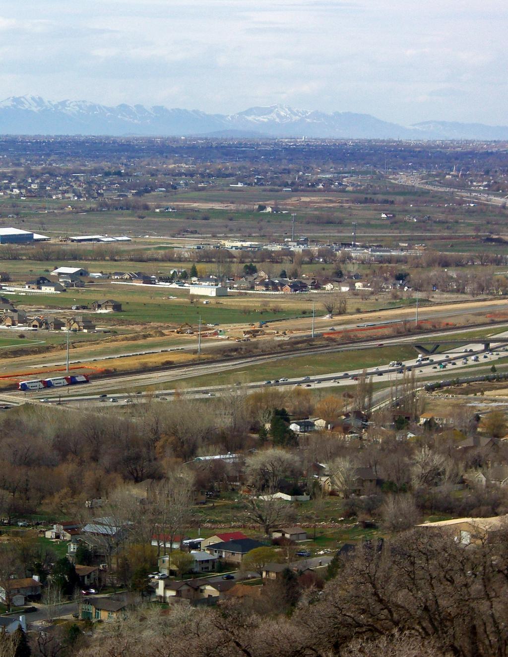
2 Need for Regional Visioning Utah is one of the fastest growing states in the country. Population along the Wasatch Front is projected to increase by 55 percent, or to be 1.5 times the current population, between now and How we accommodate this growth will largely determine the quality of life residents will experience. Regional Visioning Along with opportunities, growth creates challenges for transportation, housing choice and affordability, air quality, the economy, cost of living, critical lands, outdoor recreation areas, water, and public health. Many current trends are troubling, jeopardizing what we value most about life in Utah. Concerned with growth-related challenges, elected officials recognized the need to look well into the future and plan for the changes that are coming. In response to these concerns, Wasatch Choices A Four County Land Use and Transportation Vision was developed and included both a Regional Vision and a set of Growth Principles. For the RTP, the WFRC updated its original work. Known as the Wasatch Choice for 2040, this revised version of the Region Vision has been adopted by the Wasatch Front Regional Council. WFRC 2040 RTP Salt Lake City Chapter 2 Photo at Left: The Interstate 15 corridor and FrontRunner commuter rail run parallel to Legacy Parkway, which is under construction in this photo. This critical transportation corridor facilitates commuter mobility between northern and southern Davis County and is an integral transportation component in the larger, regional context. W N S E Regional Transportation Plan : Charting Our Course 37
3 WASATCH CHOICE FOR 2040 In 2004, the WFRC, MAG, UDOT and UTA, with assistance from staff members of Envision Utah, initiated the Wasatch Choices 2040 effort with the goals of finding a more effective approach to transportation planning in Weber, Davis, Salt Lake and Utah Counties. Thousands of residents, local technical experts and elected officials contributed to Wasatch Choices 2040 through workshops, scenario building, independent polling, and on-line surveys. Wasatch Choices 2040 identified a series of growth principles, a regional vision and implementation strategies to guide local development decisions and make the Region s transportation system more efficient and cost-effective. Subsequently, the WFRC, MAG and Envision Utah, in close collaboration with local elected officials, further refined the vision, creating The Wasatch Choice for In 2010, WFRC formally adopted The Wasatch Choice for 2040 as the Regional Vision designed to address our Region s growth and provide the foundation for the 2040 RTP. Reasons for Visioning The Wasatch Front Region is creating the type of future it desires with the decisions we make today. Visioning allows planners to explore potential futures relative to growth patterns, transportation solutions, and the environment. By understanding the needs of the future, planners can work backward to the decisions that need to be made today. The regional visioning process emphasizes using our limited financial resources more effectively, integrating land-use and transportation systems, meeting housing needs, building in areas with existing infrastructure, and energy conservation. It envisions new mixed-use villages and economic centers tied together by an efficient, modern transportation system. This Vision for the future of the four urban counties is based on extensive market research showing that changing consumer demographics and preferences, increasing land and energy costs, and a growing desire to trade commute time for family and recreation time are driving demand for living in or near centers. In short, it gives people the housing and transportation choices they want in a way that maximizes land use and benefits everyone. Growth Issues The State of Utah enjoys an unparalleled quality of life, access to the outdoors and rich economic opportunities. The State also has a significant population growth challenge. Utah has one of the nation s highest population growth rates, recently ranked as sixth highest in the country. A majority of anticipated growth will occur within the urbanized areas of Weber, Davis, Salt Lake, and Utah County. In the next 30 years, population will increase by 61 percent, adding another 1.3 million residents. If growth patterns of the past few decades continue, the consequences will be an intensification of the social, economic, and environmental impacts noted elsewhere in this document. With the growth in population, the anticipated growth of daily VMT on the Region s roads will nearly double from 49million to 90 million by As the population continues to grow, and VMT nearly doubles, the Region s overall air quality will deteriorate, threatening our health and economic prosperity. If current trends continue, nearly 300 square miles in the Weber, Davis, Salt Lake, and Utah Counties will be converted to urban use by About 100 square miles of this land will have formerly been used for agricultural purposes. Finally, the cost of growth-related municipal infrastructure is also of concern. Growth-related expenditures which include transportation, water and utilities rose from 31 percent of local municipal budgets in 1982 to 61percent in Addressing Needs Through Land Use and Urban Form In order to address the growth-driven needs for new investments in the region s infrastructure, realistic alternatives need to be considered. Many of these alternatives emerged during the workshop and open house phases of the visioning process. Some of the ideas for alternatives included: (1) encouraging more compact growth and less sprawl; (2) creation of a better geographic balance between housing and the workplace; (3) encouraging mixed land use and transit oriented development; and (4) making greater use of public transportation. Many of these ideas have been studied extensively, and, if implemented properly, could help reduce travel demand and the need to construct traditionally more costly transportation infrastructure. 38 Chapter 2 Wasatch Front Regional Council

4 Regional Visioning DESCRIPTION OF VISION METHODOLOGY The visioning process was accomplished over several years. It was a new approach for laying down an informational base for the regional transportation plan and involved many technical planning and public involvement tasks. The collection of regional population, employment, land use, transportation, and socio-economic data; and the development of specialized studies, data analyses, and public surveys were essential parts of the process. The public outreach process engaged local governments as partners in identifying stakeholders who would be willing to participate in the workshops. Workshop participants were asked the following two basic questions: What is the future we want to create? and What will help us create that future? Public Outreach Process The visioning process involved an extensive public outreach program. From beginning to end, the general public, local elected officials, and others representing specific interests were given an opportunity to participate in workshops, open houses, and surveys. Much valuable information was gleaned from the outreach activities, without which the project outcomes could not have been achieved. The collaborating parties all agreed that there were many good reasons to embark on an elaborate public outreach, or visioning process. One of the reasons was clear - it is always a positive factor to encourage public participation in the development of plans. There was also a desire to involve a full range of other interested parties, such as representative of local governments, resource agencies, transportation service providers, etc. By the end of the process, all of the participants became partners in the process which helped to ensure its success. Besides the desire of the sponsors for a broad-based communitywide effort, there were other conditions which helped decision-makers determine the time was right to conduct a region-wide visioning process. These conditions included the general recognition that rapid growth is taking place, unfunded needs within the regional transportation system that needed to be addressed, the desire to maintain or even Regional Transportation Plan : Charting Our Course improve the Region s economic competitiveness, and strong interest in maintaining the quality of life. Meetings With Local Government Officials At the beginning of the visioning process, MPO staff members and representatives from Envision Utah met with each local government entity to educate them on the visioning process, address any questions, and to develop inclusive stakeholder invitation lists for the thirteen scheduled workshops. Face-to-face meetings were held with the chief elected official and key staff members and, at their discretion, meetings were also held with the governing body and / or the planning commission. Public Workshops A total of thirteen workshops, involving over 1,000 participants were held as part of the visioning process. Meetings took place in the cities of Ogden, Roy, Bountiful, Layton, Sandy, Riverton, South Salt Lake, Taylorsville, Pleasant Grove, Orem, Lehi, Payson, and Salt Lake City. At each workshop participants received instructions on the visioning process and copies of preference questionnaires. Participants were organized into small, randomly assigned groups. They were given a map of their county and asked to indicate: (1) where growth should take place; (2) the density of growth they would prefer; and (3) their transportation preferences. This resulted in the production of 119 maps for the four-county area indicating opinions, ideas and preferences about growth. Each group received chips 39
5 representing different types of residential, commercial, and mixed-use development. The total number of chips equaled the 2040 growth projections made by the Governor s Office of Planning and Budget for the four-county area. Each group was asked to accommodate projected growth through current types of development or through alternative approaches such as mixed-use activity centers or linear (boulevard) corridors. Workshop groups also indicated where they wanted transportation facilities, including new or improved transit, roadways, and bicycle lanes, and pedestrian trails. The results of the workshops and surveys were tallied and analyzed. Common themes and concepts emerged that guided the development of four growth scenarios that can be described as: Scenario A: Business as Usual (baseline) Scenario B: Transit Station Villages Scenario C: Interconnected Network of Complete Streets Scenario D: Centers of Employment Public Open Houses Five stakeholder open houses involving 500 participants were held in cities throughout the region to review and consider the four growth scenarios that emerged from the public workshops. At each open house, participants were surveyed to identify the scenario they preferred and asked to respond to other growth-related questions. The findings of this survey, as well as comments received on-line, from a variety of public meetings and from members of city councils and planning commissions, served as the basis for initial drafts of the vision scenario. Surveys and Questionnaires As noted above, surveys were conducted at various stages of the visioning process. Early in the process the workshop survey was conducted, followed by a Dan Jones telephone survey, and the open house participant surveys. During workshops, questionnaires were distributed to determine the opinion of participant s regarding the natural environment, growth, and transportation issues that are challenging the region. Those surveyed indicated they generally enjoyed their quality of life, but are concerned about growth. Most residents supported adopting and integrating growth principles into future land use and transportation planning decisions. Local Government Visits, Presentations, and Input Once the visioning process was concluded, the results were shared with the local government officials. The Regional Growth Principles and Vision were presented to all 47 local governments in the urbanized areas of the region. Representatives from the WFRC and Envision Utah met with municipal and county elected officials. A slide presentation highlighting the growth principles and Vision was used to explain how the Growth Principles were generated and would be used to prepare the Regional Transportation Plan. An overwhelming majority of these officials said they would support the growth principles. Most responded positively to the land use scenarios proposed in the Vision statement calling for the establishment of mixed-use activity centers of various sizes, connected by high capacity transportation facilities, an enhanced public transit system, and somewhat more compact growth. By and large, local government officials agreed with the proposed land use recommendations, with some suggesting minor changes to the proposed Vision land use map. A few communities indicated they would use their existing plans as a guide to future development, rather than the Vision statement. The input received during these meetings was noted and used in creating a refined land use Vision map. Subsequently, this refined map was used as a basis for generating the land use inputs to the transportation demand modeling process. Technical Support Activities The WFRC staff provided significant technical support to the visioning process. During the workshops and open houses, information which was used to develop various growth scenarios was obtained from the participants. The workshop activities resulted in the generation of valuable input, were useful in determining community values, and helped identify the types of development that is most desired. The growth scenarios presented in the workshops required data support and modeling so that they could be tested to determine practicality and effectiveness. What follows is a detailed explanation of what was accomplished and methods used in developing and testing the growth scenarios. Map Analysis of Land Use and Transportation Each of the 119 maps produced during the workshop process were generated by groups of six or seven participants. The maps show local community desires for the distribution of future Regional growth in population, employment, commercial 40 Chapter 2 Wasatch Front Regional Council
6 businesses, office, schools, trails, and transportation; and how to protect critical and sensitive lands. These maps were digitized into a geographic information system (GIS), which allowed for an analysis of preferences, and a summarization of issues, concerns, and common themes. The GIS maps helped answer the following questions: (1) Where did the participants of each group desire new development to take place and critical lands to be preserved?; (2) What type of development did the groups desire - residential, commercial, or mixeduse?; and (3) How dense or intense did the groups want development to be? The maps were also analyzed to identify preferred types of development in any given area, such as: residential, commercial, mixeduse, or open space. Based on input from the maps, participants desire that growth take place in older urbanized areas and along heavily used transportation corridors and around specific types of development nodes. The participants also encouraged mixeduse forms of development in existing commercial centers, such as the Layton Mall and downtown Salt Lake City. Hot spots, where intense employment centers would be appropriate, were also identified. The summary GIS maps were subsequently used to serve as a basis in further explaining the alternative growth and vision scenarios. Managing the Process The visioning process started with a work scope, funding plan, budget and a Memorandum of Agreement between the three participating organizations. The work scope outlined work tasks to be undertaken through the visioning, and identified a division of responsibility between the partnering entities. A working group was organized early to help guide the process. This group was called the Collaboration Group, and was comprised of representatives of the partnering entities, the Utah Department of Transportation, the Utah Transit Authority, and the Governor s Office of Planning and Budget. In addition, the Regional Growth Committee of the WFRC was expanded to include a broader spectrum of stakeholders from the business community, local governments, state and federal agencies, special interest groups, and others. Representatives of local government, and the business community from Utah County were also invited to participate in the expanded RGC. The expanded Regional Growth Committee was temporarily designated as the RGC Steering Committee, and was given responsibility for guiding the process and making recommendations to the WFRC and MAG. COMMON REGIONAL THEMES An analysis of the 119 maps developed during the workshops showed striking similarities tempered with divergent ideas. After an extensive review of the workshop maps, the general themes discussed in the following paragraphs emerged. These themes became part of the overall visioning recommendations and were incorporated into the Wasatch Choices for 2040 draft document. Regional Transportation Plan : Charting Our Course 41
7 Emphasis on Growth Centers Workshop participants envisioned approximately 40 percent of all new residential development be in the form of a mixed-use scenario, such as a village, town center, or city center. This may signify a desire to have employment centers in each part of the Region; a desire to have a focal point, or heart for each community; and / or an interest in a walkable form of development that mixes jobs, shopping and housing. Desire for Land Recycling In addition to having more centers in the communities, workshop participants preferred that the centers be located in existing commercial areas adjacent to major transportation facilities. Participants placed nearly 50 percent of the proposed housing and 45 percent of the proposed employment on land that is currently occupied. Perhaps this signifies an interest in the gradual evolution of some commercial areas. Preference for a Variety of Housing Workshop participants preferred that neighborhoods maintain much of their current ambience, but with a notable increase in the variety of housing options. Residential chips placed on workshop maps averaged 60 percent detached stand-alone homes, 25 percent townhouses, and 15 percent apartments or condominiums. The urbanized portion of the region currently consists of 67 percent single family dwellings. Although participants expressed an interest in a greater variety of housing, they still desired detached single-family residences to predominate in future communities. Emphasis on Bicycle and Pedestrian Routes Approximately 30 percent of all transportation routes placed on workshop maps represented bicycle and pedestrian routes, indicating the popularity of these options. Clearly, participants felt that an extensive system of bicycle and pedestrian routes should be encouraged to promote flexibility in transportation choices and to encourage healthy recreational activities. SPECIAL STUDIES In support of the visioning process, several specialized studies were conducted to provide additional information and direction in establishing realistic assumptions about redevelopment, infill, housing market demand, open space and corridors. The visioning process benefited from these studies, which highlighted important areas of concern. Redevelopment and Infill Potential Analysis A local consulting firm was hired to assist with creating estimates of long-term redevelopment and infill activity that could be reasonably anticipated, given different patterns of development and transportation investments. As a part of this effort, tax lot parcel databases were consulted for the affected counties. An effort was made to account for the availability of underutilized land not readily apparent from the county databases. To further the effort, the University of Utah s Energy and Geosciences Institute provided information from its satellite imagery database. Parcels greater than one acre in size were analyzed to distinguish the degree to which they had already been developed. Exceptions were made in analyzing the parcels to account for vacant properties associated with public uses and other factors that precluded them from future development. The output of this analysis was then applied to the land use modeling process for each of the four general growth scenarios evaluated in the visioning process allowing for further refinement and accuracy. These four growth scenarios are detailed in the following section. Housing Needs and Market Trends Assessment A market study was also conducted to identify the anticipated residential development preferences during the 2040 forecast period. The results were to be used to evaluate the growth scenarios and how they relate to the potential demand for various kinds of housing. The primary goal of the study was to document market conditions and forecast residential demand. It focused on the evaluation of the residential market trends and factors, which would affect demand and preferences, and to use this information to forecast the types of homes future residents would prefer in an unconstrained market. The methodology intentionally eliminated from consideration the impact of, or potential changes to local or regional land use policy, as they would be addressed in the visioning process and did not reflect potential environmental constraints, such as water supply or air quality. An independent forecast of future single-family lot sizes was also provided. Quantitative and qualitative trends and factors were used in the study. Quantitative data included demographic trends and forecasts, housing production trends, residential sales, and development densities. It also included a broad analysis of 42 Chapter 2 Wasatch Front Regional Council
8 qualitative trends reflecting demographic preferences, relevant development case studies, and evaluations of other metropolitan areas. The analysis also accounted for new opportunities for transit-oriented development (TOD). The study results were synthesized into specific calculations of forecast demand by decade, by county, for single family and multi-family units, with details regarding densities and configurations. Critical Lands and Regional Trails Network A third study was conducted to review critical lands in conjunction with the visioning process. The purpose was to evaluate the impact that land use and transportation (growth) scenarios would have on a variety of critical lands, and to incorporate a regional open space and trails component into the preferred Vision for the region. To facilitate the analysis GIS mapping of open space and trails was augmented by the workshop process. Participants were given the opportunity to draw green areas on the maps to indicate preferences for open space and to delineate trail routes. In addition, at the open houses that followed the workshops, public surveys were conducted relating to critical lands and trails. The findings of the study provided data for analysis of how future growth within the region could either downgrade or remove critical lands, or preserve key areas for the enjoyment of future generations. The study also created a vision of a regional trails network that could encourage walking, other recreational uses, and improve access to open areas. This information was then used in the UrbanSim land use allocation model for each growth scenario and precluded any type of development from being allocated to the parcels identified as critical lands. SCENARIO DEVELOPMENT PROCESS With public outreach well underway and completion of the special studies the WFRC, MAG, and Envision Utah identified common themes and began to develop planning scenarios. Planners from these three organizations, guided by the workshop maps and survey results, developed four sketch scenarios - or visions - of what the region could become by The sketch scenarios reflected the common themes and notable differences identified in the workshops. Scenario Development The four sketch scenarios for the horizon year 2040 were tested and compared to one another using various growth and transportation ideas identified in the workshops, to determine how well they performed in achieving the Regional Vision. All four of the scenarios incorporated the same projected population and employment figures. However, each, scenario separately highlighted different transportation choices, the cost of which was approximately the same for each scenario. By eliminating differences in population, employment and transportation costs, the four scenarios could be tested for the effects of different growth and the transportation strategy options. Scenario A: This scenario reflected current trends and was named the Business as Usual Scenario. It was based on the existing municipal, county and multi-county plans to guide future growth and transportation. To determine how the impacts of each scenario might differ from current trends, Scenarios B, C, and D were compared to Scenario A. Scenario B: This scenario named Transit Station Villages is characterized by activity centers clustered near transit stops and stations. The suburbs generally retain the same density as found in the Business as Usual Scenario - with occasional neighborhood villages having a mix of apartments, condos, and neighborhood shopping. Scenario B included a significant increase in the amount of rail transit by emphasizing rail extensions and bringing light rail and commuter rail to more communities than currently planned. Scenario C : This scenario was named Interconnected Network of Complete Streets. Rather than encouraging development around transit nodes as in Scenario B, Scenario C intensified mixed-use development along walkable boulevards. These boulevards would be lined with townhouses, shopping, and office development (employment). New suburban neighborhoods in Scenario C remained largely residential and lower density in character. Scenario C s boulevards would represent an interconnected network of complete streets that encourage the use of streetcars, biking and walking. Regional Transportation Plan : Charting Our Course 43

9 destinations, which significantly reduced average diving distances. This in turn reduced traffic congestion and improved air quality. Urban growth near transit opportunities encourages people to ride transit. Scenario B shows that if transit stations or bus stops are within walking distance of homes and businesses, more people find riding transit to be convenient. People will walk or use bicycles if the trip is short and the design (for pedestrians and cyclists) is convenient. If commercial destinations, like an office building or restaurant, are very close to each other and are located in a pedestrian-friendly setting, many people will choose to walk between them, rather than drive their vehicle. Scenario D: This scenario was named Centers of Employment. Scenario D was characterized by a greater number of strong suburban centers of employment in closer proximity to housing areas. Suburban neighborhoods had a greater mix of lot sizes and included more townhouses, apartments and condos. Scenario D emphasized new freeways and major roads to serve the Wasatch Front Region s growing areas. Scenario Evaluation Examination of the scenarios and evaluation criteria resulted in some interesting observations. For instance, different patterns of land development can ease vehicle access, but aggravate mounting transportation challenges. By contrast, in a different scenario, the proposed future development patterns can help solve the mounting transportation challenges and reduce the rising cost of providing growth related infrastructure. Specific observations about the effects of different patterns of development follow. Mixed-use development reduces driving distances and congestion. The distance traveled to work, shopping, schools, or parks is largely a function of the distance between these destinations and residences. The distance traveled per person directly affects the collective time it takes travelers to get where they need to go and the traffic congestion they are part of. Scenario C contained a higher mix of homes with Transit-oriented development is a key strategy to increase redevelopment in existing urban areas and to reduce demand for growth on underdeveloped land. Scenario B s emphasis on high capacity transit coupled with transit villages created more opportunities for reuse of land or redevelopment. Scenario B also exhibited the highest rate of redevelopment and, not surprisingly, also exhibited the lowest amount of development on vacant and critical lands. Transportation choices help to determine where growth will occur and how much land area will be developed. The type of transportation solutions that are provided has an impact on the way communities grow and develop. New roadways and transit facilities, wherever they are built or expanded, increase accessibility, which in turn attracts growth. As planners and decision-makers consider where they should invest transportation dollars, they should ask the question, Where do we want to encourage new growth - on redeveloping industrial and other urbanized properties, on vacant land near existing communities, or in new undeveloped areas? Interconnected streets help keep short trips off major highways and reduce congestion. Interconnected streets facilitate free traffic flow and the use of more direct routes. They also promote neighborhood cohesion. The length of time it takes to reach destinations is a function of distance as well as congestion. Shorter driving trips and less congestion mean 44 Chapter 2 Wasatch Front Regional Council
10 that if regional development takes place in accordance with the strategies embodied in Scenario C, there will be more time available for people to pursue individual choices and less time in congestion. The scenarios generally assumed that people who ride public transportation with its own dedicated rightof-way mostly bypass congestion. Generally, transit is a key means of reducing congestion during the all-important peak use periods. Even if transit carries only a small percentage of overall trips, it plays an important role in relieving rush-hour congestion. Data indicates that In Salt Lake County, TRAX carries the equivalent of one lane of freeway traffic during peak hours. Strategic changes make a big difference. Surprisingly, the benefits of Scenarios B, C, and D, when compared to the business as usual Scenario A, are the result of relatively minor changes to the density of the region s housing and land use. For example, Scenario C assumes about 27 percent townhouse and multifamily development, only 6 percent more than the business as usual Scenario A. The strategic placement of this type of development in walkable and mixed-use settings adjacent to transit is largely responsible for the advantages that Scenario C anticipates. This Scenario realized nearly a 10 percent reduction in congestion and a 3 percent reduction in vehicle miles traveled. Strategic changes throughout the region can vastly improve the individual quality of life without negatively impacting existing single-family neighborhoods to the degree that a more sprawling pattern of development would create. SCENARIO MODELING PROCESS The patterns of land use and the transportation systems in urban communities play a critical role in determining the livability and sustainability of those urban areas. It is important to model these patterns in an integrated way to reflect the strong interaction between land use and transportation. In this effort, the WFRC used an integrated modeling system, UrbanSim, as an analytical tool for the scenario modeling process to compare multiple land-use and transportation scenarios in a manner consistent with urban growth theory. UrbanSim is a state-of-the-art approach to forecasting future land-use growth with growth forecasts influenced by the nature of the proposed transportation system. By coupling UrbanSim with the regional travel demand model system, a range of land use and transportation policy interventions are combined into policy scenarios, and the systematic effects of these intervention strategies can be expressed in terms of projected urban development outcomes and the quality of the transportation system. Modeling System Input Critical inputs to the modeling system include base year socio-economic data, jurisdictional master plans, environmental constraints and the proposed future transportation system. The primary input for the UrbanSim model includes the base year data and future land use policy data. The base year data describes existing development and socioeconomic environment for the base year. This information includes households, employment, dwelling units, non-residential square footage, stated local government land use planning preferences, and environmental factors. All of this information is broken down to a 150-meter by 150-meter square area, called a grid cell, which contains an area of just over 5.5 acres. The grid cell is the basic unit for the UrbanSim model. There are approximately 150,000 grid cells covering the entire region. The future land use policy data includes the land use plans of various municipalities and the counties for the unincorporated areas. For the regular travel demand model, the main inputs include socioeconomic data and transportation system data. In the integrated modeling process the socioeconomic data is automatically derived from the UrbanSim modeling process. Therefore, the main input data for the travel demand model is the proposed future transportation system, which is described as the highway network, transit networks and other features. From a modeling perspective, the highway network data are the number of lanes and the functional type for each roadway facility of every model year. The transit network data include all modes (Local Bus, Express Bus, Bus Rapid Transit, Light Rail/Streetcar, and Commute Rail) and all transit routes, their frequency and speed, park and ride nodes, walk access links, etc. Based on the output from workshops and input from local government planners, four land use and transportation scenarios were developed to test various growth and transportation concepts. The tested scenarios are described in the Scenario Development section of this chapter. Regional Transportation Plan : Charting Our Course 45
11 Modeling System Output In this iterative land use and transportation model system, the resultant UrbanSim socio-economic data for each future year that falls within the 2040-planning horizon is entered into the Travel Demand Model. Various UrbanSim output data for every future year are analyzed before use in this process. These data include dwelling units, households, non-residential square foot, employment, land use consumption, land use type etc. The travel demand model output consists of highway related and transit related information. The highway related information includes vehicle miles traveled (VMT), vehicle hours traveled (VHT), delay, speed, lane miles, etc. This information can be reported at different geographic levels such as region, county or municipality. It can also be classified for different functional types for the roadway facilities in the region. Transit information includes mode share by purpose and boardings, and other information collected at stations or a route level. On the basis of these model outputs, the tested scenarios were examined, compared and evaluated. DEVELOPMENT OF THE REGIONAL VISION Extensive surveys conducted for the visioning process were used to determine the general population s preferences and values with regard to growth and development. The results were used to develop criteria by which the various scenarios were tested. The preferred scenario of transit station villages, Scenario B, is characterized by activity centers clustered near transit stops and stations with the remainder of suburban areas generally remaining at the same density and with occasional neighborhood villages having a mix of apartments, condos, and neighborhood shopping. The second most preferred scenario of an interconnected network of complete streets, Scenario C, intensified mixed-use development along walkable boulevards lined with townhouses, shopping, and office development with new suburban neighborhoods remaining largely residential and lower density in character. This scenario represented an interconnected network of complete streets that encourage the use of streetcars, biking and walking. The WFRC s evaluation of these scenarios resulted in a combination of the best aspects of each, and the emergence of the draft Vision. Refinement of the Regional Vision The draft Vision was based on taking a combination of the best components of the preferred Scenarios. Revisions were undertaken based on input from the Technical Advisory Committees, the Regional Growth Committee, and various jurisdictions and stakeholders. Cues were taken directly from workshop results for locating mixed-use development centers and new transportation concepts. As a result, centers of development were located in central locations well served by existing and projected high capacity transportation facilities. As the Vision matured the Regional Council Staff with the assistance of Envision Utah and other consultants continued to refine the Vision. Workshops were held in each of the four urbanized counties along the Wasatch Front. Local government planners and engineers provided input on how land use within their respective general plans could be improved to better reflect the projected growth throughout the region. Specific growth assumptions associated with the draft refined vision were reviewed for plausibility, consistency with local plans, and to incorporate knowledge of major development proposals that have a reasonable likelihood of being developed over the RTP planning horizon. As jurisdictional planners reviewed the draft vision refinement, they were reminded that county control totals would be maintained and, for that reason, many areas would have a growth assumption for 2040 that is below what their individual general plans allow, or the total jobs and households one might see in a potential major development. Consultants considered the balance of households and jobs in sub-county areas to ensure the vision assumed a reasonable complement of retail and non-retail jobs in housing-rich areas. A balance of jobs and housing is a principle of the Wasatch Choice for 2040, so housing was likewise added to job-rich areas. Consultants ensured that the overall assumption for infill and redevelopment region-wide was also plausible. Consultants considered redevelopment and infill rates in other metropolitan areas whose current population approximates the WFRC/Mountainland MPO population projection for As the Vision was refined, the approximate percentage of growth that could be assumed through infill and redevelopment was maintained. Consultants also revised the Vision to better approximate recent land use trends. For example, more growth was assumed in southwestern portions of Salt Lake County. 46 Chapter 2 Wasatch Front Regional Council

12 Application of the Vision Scenario and Growth Principles Once the Vision Scenario was finalized, the WFRC used it as a guide in the development of the Regional Transportation Plan. The land use suggestions that were used as an input to the demand modeling process were developed from the land use preference generated through the Vision Scenario. Revisions to the Vision Scenario land use recommendations were based on input from local government staffs and elected officials. The Regional Growth Principles were a resource in developing the evaluation and performance criteria used in the evaluation of future transportation needs, and the transportation system. The growth principles were also used in determining, ranking and projecting highway and transit projects in the 2040 RTP. Urban Sim Urban Sim relied on a set of statistical models that note patterns in the way the region has developed. The approach is designed to support metropolitan planning and policy analysis. One important advantage to this approach is that growth forecasts are influenced by the quality of the proposed transportation system. By coupling UrbanSim with the regional travel demand model system, a range of land use and transportation policy interventions are combined into policy scenarios, and the systematic effects of these intervention strategies can be used to project urban development outcomes and to assess the quality of the transportation system. Modeling System Inputs and Outputs Critical inputs to the modeling system include base year socio-economic data, jurisdictional master plans, environmental constraints and the proposed future transportation system. The model outputs include dwelling units, households, nonresidential square footage, employment, land use consumption and land use type, as well as highway and transit related information. More detailed information on model inputs and outputs can be found in the previous section entitled, Scenario Modeling Process. WASATCH CHOICE FOR 2040 VISION The Wasatch Choice for 2040 Regional Vision is used to guide implementation of land use and transportation strategies that will result in more sustainable and livable communities for generations to come. The Vision will help maintain the high quality of life for the residents of the Wasatch Front as the population increases dramatically over the next three decades. Among other things, the Vision emphasizes using our limited financial resources more effectively, integrating land-use and transportation systems, meeting housing needs, building in areas with existing infrastructure, and energy conservation. It envisions new mixed-use villages and economic nodes with higher density centers tied together by an efficient, modern transportation system. This Vision for the future of the four urban counties is based on extensive market research showing that changing consumer demographics and preferences, increasing land and energy costs, and a growing desire to trade commute time for family and recreation time are driving demand for living in or near centers. In short, the Vision gives people the housing and transportation choices they want while maximizing transportation investments and land use benefits. Implementing The Wasatch Choice for 2040 will provide significant quality-of-life benefits: Billions of dollars saved in infrastructure, housing and transportation costs Savings in travel time which can be used for other purposes Improves air quality for our health and economic growth Regional Transportation Plan : Charting Our Course 47

13 Regional Visioning Maintains the character of existing neighborhoods Preserves key agricultural lands and other open spaces Provides housing for people of all life stages and incomes Uses less of our limited water resources Creates more active neighborhoods, supporting increased recreational activities Enhances the local economy and the ability to attract and retain skilled workers Provides more choices for how this and the next generation will live, work, and travel By implementing the Vision, we can accommodate growth, enjoy more financial security, build first-class communities, and preserve the stunning beauty of our state. Regional Growth Principles and Objectives The nine Regional Growth Principles embody many of the values held by residents of the Wasatch Front Region. These Principles were adopted by the Regional Council after reviewing input from community workshops, open houses, committee deliberations, and polling. The Growth Principles are intended to promote quality growth throughout the Region. It is important that new growth be guided so that it can occur and be accommodated in the most efficient and cost effective way. The Growth Principles were also intended to serve as a context for implementing general plans developed by local, state, and other entities. The Principles reflect community values and recognizes the importance of longterm sustainability and the need to make wise choices with limited resources. They serve as a resource in developing criteria and performance measures for regional transportation planning relating to the environment, economy, transportation, and other factors. It is recognized that collaboration will be needed among the Wasatch Front Region s local governments and others if these principles are to be implemented and their potential benefits realized. 48 Chapter 2 Regional Growth Principles 1. Provide public infrastructure that is efficient and adequately maintained 2. Provide regional mobility through a variety of interconnected transportation choices 3. Integrate local land-use with regional transportation systems 4. Provide housing for people in all life stages and incomes 5. Ensure public health and safety 6. Enhance the regional economy 7. Promote regional collaboration 8. Strengthen sense of community 9. Protect and enhance the environment The Regional Vision The Regional Vision, the Wasatch Choice for 2040, aims to represent a pattern of growth and transportation solutions that reflect the spirit of the Growth Principles and is a plausible future. For example, the Wasatch Choice for 2040 pictures walkable villages - centers of housing and commercial enterprises arranged in a pedestrian-friendly setting - emerging in areas that are currently used for commerce and industry, but not in current residential subdivisions where such change would likely not be welcomed by the community. Change is envisioned primarily in strategic areas of regional transportation significance, which are the most central, accessible and high capacity transportation locations in the Region. Wasatch Front Regional Council
14 The Vision and Development Patterns In The Wasatch Choice for 2040 Vision, the walkable, mixed-use centers of development would act like a growth sponge, absorbing future growth that would otherwise occur on the edge of our suburban communities. These centers help to create community gathering spaces, giving communities a sense of place. Opportunities for moderately priced housing with readily accessible public transportation would be important components of the mixed-use centers. Mixing land uses would allow for more efficient use of available land. The concentration of residential, office, retail, and well-planned open space would allow individuals the opportunity to live, work, shop, and recreate all within the confines of a limited geographic area or neighborhood. The Vision and Critical Lands The Wasatch Choice for 2040 Vision pictures a comprehensive system of green corridors connecting communities with trails and providing green buffers next to creeks and rivers. This trail and open space network includes the Jordan River Parkway, the Bonneville Shoreline Trail, Farmington Bay Bird Refuge, and a wide variety and location of regional and neighborhood parks. The system of trails would allow for increased opportunities for walking, biking, wildlife viewing, and relaxing. The protection of open space would offer opportunities for the protection of critical habitat areas, improving water quality, and protecting watersheds. The Vision and Transportation The Wasatch Choice for 2040 Vision balances a variety of transportation forms: (1) The Vision highlights the role that walking and bicycling can play as options for making daily trips; (2) The Vision recognizes that auto travel will continue to be the dominant form of transportation, but that greater use of interconnected boulevards from community center to community center can reduce the need to use freeways and expressways; (3) The Vision highlights the value that transit has in providing a more efficient alternative to single occupant auto travel, while reducing household transportation expenses. As growth continues, opportunities for proper planning and infrastructure investments will become apparent, thereby minimizing congestion and increasing transit options. Map 2-1 shows the Wasatch Choice for 2040 Region Vision with a description of green space, centers, and corridors. Appendix E is a specially developed brochure, entitled Wasatch Choice for 2040, We Can Choose a Better Future, which highlights the planning process, the benefits, and illustrations of different strategies to better implement the of the Regional Vision. Implementation Strategies for Local Governments The Growth Principles and Objectives lay the foundation for maintaining or improving the quality of life as the Wasatch Front Region continues to grow. The Wasatch Choice for 2040 Vision process also identified strategies for implementing these growth principles. Below is a list of ten strategies for local governments to consider as they explore various methods by which Growth Principles and Objectives could be implemented. These strategies are basic primers intended to highlight initial steps and considerations. Strategies For Local Governments 1. Develop a local land re-use strategy 2. Provide incentives for contiguous growth and infill 3. Preserve future transportation and utility corridors 4. Create walkable commercial and mixed-use districts 5. Plan for transit oriented development 6. Plan for and build neighborhood-friendly elementary schools 7. Crate a plan for workforce housing 8. Interconnect roadways and pedestrian paths 9. Plan for job centers and economic development readiness 10. Minimize development and maximize conservation on and near critical lands IMPLEMENTATION OF THE VISION The implementation of the Wasatch Choice for 2040 Vision is a priority if the Region is to ensure its future quality of life. The WFRC staff conducted a special study to explore how the Vision and Regional Growth Principles might be utilized to produce the type of sustainable corridor development desired. The historic and regionally important State Street corridor was selected as a case study example. This Visioning exercise, entitled Life On State - Our Street, Our Vision (LOS), was a collaborative planning effort to develop: (1) a vision for the future of State Street; (2) a toolbox to aid in vision implementation; and (3) a focused planning effort on three or four defined areas where the Growth Principles are applied directly to improve the overall quality of this important Regional Transportation Plan : Charting Our Course 49


15 Map 2-1, WASATCH CHOICE FOR 2040 VISION MAP OVERVIEW
Wasatch CHOICE for 2040
 Wasatch CHOICE for 2040 Economic Opportunities We Can Choose a Better Future We enjoy an unparalleled quality of life along the Wasatch Front. People from all over the world are drawn to our stunning scenery,
South Davis County COMMUNITY SPOTLIGHT
 South Davis County COMMUNITY SPOTLIGHT Davis/SLC Community Connector Bus Rapid Transit line connecting SLC & Davis County RTP Phase 1 Project Generate 3,100 average weekday riders Relieve congestion on
CHAPTER 7: Transportation, Mobility and Circulation
 AGLE AREA COMMUNITY Plan CHAPTER 7 CHAPTER 7: Transportation, Mobility and Circulation Transportation, Mobility and Circulation The purpose of the Transportation, Mobility and Circulation Chapter is to
Sacramento Area Council of Governments (SACOG)
") Sacramento Area Council of Governments (SACOG) The Blueprint Vision The SACOG Board of Directors adopted the Preferred Blueprint Scenario in December 2004, a bold vision for growth that promotes compact,
Sacramento Area Council of Governments (SACOG) The Blueprint Vision The SACOG Board of Directors adopted the Preferred Blueprint Scenario in December 2004, a bold vision for growth that promotes compact,
weber davis WASATCH CHOICES 2040 A Four County Land-Use and Transportation Vision
 weber davis WASATCH CHOICES 2040 A Four County Land-Use and Transportation Vision salt lake A FOUR COUNTY LAND-USE AND TRANSPORTATION VISION ENVISION UTAH GRATEFULLY THANKS THE FOLLOWING FUNDERS OF THE
REVIEW AND EVALUATION OF REGIONAL LAND USE
 REVIEW AND EVALUATION OF REGIONAL LAND USE AND TRANSPORTATION SCENARIOS #220831 Environmental Justice Task Force October 7, 2014 VISION 2050 Process Development of Guiding Vision for Land Use and Transportation
Chapter 1.0 Introduction
 Chapter 1.0 Introduction 1.1 Background The North Metro commuter rail line is part of the RTD FasTracks regional transit system expansion program to build more than 100 miles of rail transit throughout
4.1.3 LAND USE CATEGORIES
 4.1.3 LAND USE CATEGORIES a. City Center District The City Center District incorporates the existing character and mix of uses in downtown Belmont to encourage redevelopment and new development in keeping
2040 LUP is a part of the Comprehensive Plan and carries the same legal authority. Economic Challenges
 1.1. Guiding Anchorage s Growth Where will new residents settle over the next two decades? Where will people work, shop, and play? Will there be enough room to grow? How will Anchorage look? Will growth
Living in Albemarle County s Urban Places
 Living in Albemarle County s Urban Places ALBEMARLE COUNTY, VIRGINIA A Closer Look at Albemarle s Approach to Managing Growth and Creating Quality Urban Environments www.albemarle.org Page 2 Living in
CHAPTER 1. Ms. Guajardo s Class - Central Elementary CH 1 1
 INTRODUCTION CHAPTER 1 Ms. Guajardo s Class - Central Elementary CH 1 1 1.1 SETTING South Centre City is a linear corridor south of Downtown Escondido paralleling Centre City Parkway and South Escondido
Chapter 4. Linking Land Use with Transportation. Chapter 4
 Chapter 4 Linking Land Use with Transportation Chapter 4 59 Chapter 4 Linking Land Use with Transportation Community Design and Transportation Program Introduction Since the 1950s, the predominant development
Official Plan Review
 Official Plan Review Summary Report - The Built Environment August 2014 Part 1: Introduction Planning for a healthy, prosperous and sustainable community is an important goal for our municipality. From
6 Growth Management Challenges and Opportunities
 6 Growth Management Challenges and Opportunities The Town has established a goal of attaining a 50% participation rate with respect to employment opportunities versus residential population. The Town s
CHAPTER 3 VISION, GOALS, & PLANNING PRINCIPLES. City of Greensburg Comprehensive Plan. Introduction. Vision Statement. Growth Management Goals.
 CHAPTER 3 VISION, GOALS, & PLANNING PRINCIPLES Introduction The Greensburg Comprehensive Plan is intended as a working community document. A combination of long and short-term goals, this document is intended
Town Center (part of the Comprehensive Plan)
") Town Center (part of the Comprehensive Plan) Mercer Island Town Center Looking North (2014) In 1994, a year-long process culminated in a set of design guidelines and code requirements for the Town Center
Town Center (part of the Comprehensive Plan) Mercer Island Town Center Looking North (2014) In 1994, a year-long process culminated in a set of design guidelines and code requirements for the Town Center
REGIONAL ACTIVITY CENTER
 DRAFT REGIONAL ACTIVITY CENTER 70 EAST BENCH MASTER PLAN DRAFT 06 Introduction The East Bench Regional Activity center is comprised of large educational, research, medical, and employment centers. These
A. WHAT IS A GENERAL PLAN?
 I. Introduction A. WHAT IS A GENERAL PLAN? A general plan is the planning guideline for the future of a city. It contains goals and policies which regulate urban development, the protection of the natural
3.0 PROJECT DESCRIPTION
 3.0 PROJECT DESCRIPTION 3.1 BACKGROUND Under California law (Government Code Section 65300 et seq.), every city and county is required to have a general plan. The general plan is to be comprehensive and
TOD 101 CREATING LIVABLE COMMUNITIES WITH TRANSIT
 1 CREATING LIVABLE COMMUNITIES WITH TRANSIT What are transit Centered Communities? Benefits of Partnerships to Support and Implement What You Will Learn Portland s Pearl District Your Trainers Today Catherine
Plano Tomorrow Vision and Policies
 Plano Tomorrow Vision and Policies PLANO TOMORROW PILLARS The Built Environment The Social Environment The Natural Environment The Economic Environment Land Use and Urban Design Transportation Housing
CITY CLERK. Parkland Acquisition Strategic Directions Report (All Wards)
") CITY CLERK Clause embodied in Report No. 10 of the, as adopted by the Council of the City of Toronto at its meeting held on November 6, 7 and 8, 2001. 10 Parkland Acquisition Strategic Directions Report
CITY CLERK Clause embodied in Report No. 10 of the, as adopted by the Council of the City of Toronto at its meeting held on November 6, 7 and 8, 2001. 10 Parkland Acquisition Strategic Directions Report
PSRC REVIEW REPORT & CERTIFICATION RECOMMENDATION
 PSRC REVIEW REPORT & CERTIFICATION RECOMMENDATION KITSAP COUNTY COUNTYWIDE PLANNING POLICIES July 2, 2012 BACKGROUND A major emphasis of the Washington State Growth Management Act (GMA) is the need to
SECTION ONE: INTRODUCTION. introduction
 introduction 1 INTRODUCTION Since it was first established in 1843 as a trading post for the Hudson s Bay Company, Victoria has evolved into a Provincial capital city that is recognized across Canada and
Gold Line Bus Rapid Transit Transit Oriented Development (BRTOD) Helmo Station Area Plan
 Helmo Station Area Plan") Appendix F Gold Line Bus Rapid Transit Transit Oriented Development (BRTOD) Helmo Station Area Plan Introduction and Purpose of the Plan The Gold Line Bus Rapid Transit facility is an eleven-mile dedicated
Appendix F Gold Line Bus Rapid Transit Transit Oriented Development (BRTOD) Helmo Station Area Plan Introduction and Purpose of the Plan The Gold Line Bus Rapid Transit facility is an eleven-mile dedicated
CITY OF CHARLOTTESVILLE, VIRGINIA CITY COUNCIL AGENDA
 CITY OF CHARLOTTESVILLE, VIRGINIA CITY COUNCIL AGENDA Agenda Date: December 16, 2013 Action Required: Adoption of Resolution Presenter: Staff Contacts: Title: James E. Tolbert, AICP, Director of NDS James
Arlington, Virginia is a worldclass
 EXECUTIVE S U M M A RY Arlington maintains a rich variety of stable neighborhoods, quality schools and enlightened land use policies, and received the Environmental Protection Agency s highest award for
North Salt Lake General Plan Update 2013
 North Salt Lake General Plan Update 2013 Acknowledgements Updating the North Salt Lake General Plan was a process that would not have been possible without the support of elected officials and the general
Implementation Guide Comprehensive Plan City of Allen
 Implementation Guide 2030 Comprehensive Plan City of Allen DRAFT 2015 Implementation Guide Allen 2030 Comprehensive Plan INTRODUCTION The Comprehensive Plan serves as a guide for the growth and development
1 Introduction. Chapter. In this chapter:
 Chapter 1 Introduction In this chapter: 1.1 A Snapshot of the Region 1.2 Towards a Sustainable Region 1.3 The Provincial Context 1.4 Purpose and Organization The Regional Municipality of York Official
V. Vision and Guiding Principles
 V. Vision and Guiding Principles The Master Plan for the Powers Ferry Corridor seeks a foundation in the desires of the community. At times, various elements of the community offered opposing viewpoints,
1.0 Introduction. Purpose and Basis for Updating the TMP. Introduction 1
 1.0 Introduction The Town of Castle Rock is situated between the metropolitan areas of Denver and Colorado Springs, amidst a unique terrain of rolling hills, mesas, ravines, and waterways. Like many Front
EXHIBIT A. Tax Increment Reinvestment Zone No. 1 (Town Center) First Amended Project Plan 1
 First Amended Project Plan 1") EXHIBIT A Tax Increment Reinvestment Zone No. 1 (Town Center) First Amended Project Plan 1 1 As amended by Resolution No. 2008-02-001(TR1R) of the Tax Increment Reinvestment Zone No.1, and approved to
EXHIBIT A Tax Increment Reinvestment Zone No. 1 (Town Center) First Amended Project Plan 1 1 As amended by Resolution No. 2008-02-001(TR1R) of the Tax Increment Reinvestment Zone No.1, and approved to
1.3 TRANSIT VISION 2040 FROM VISION TO ACTION THEME 1: PUTTING TRANSIT AT THE CENTRE OF COMMUNITIES. Fully integrate transit with community planning
 TRANSIT VISION 2040 FROM VISION TO ACTION TRANSIT VISION 2040 defines a future in which public transit maximizes its contribution to quality of life with benefits that support a vibrant and equitable society,
Introduction. Chapter 1. Purpose of the Comprehensive Plan Plan Organization Planning Process & Community Input 1-1
 Chapter 1 Introduction Lakewood 2025: Moving Forward Together Purpose of the Comprehensive Plan Plan Organization Planning Process & Community Input 1-1 Purpose of the Comprehensive Plan The Comprehensive
Making TOD Work in the Heart of Suburban Sprawl
 Making TOD Work in the Heart of Suburban Sprawl Rocky Mountain Land Use Institute March 6, 2009 Speakers Ben Herman, FAICP, Principal Clarion Associates Darcie White, AICP, Principal Clarion Associates
CHAPTER 7: VISION AND ACTION STATEMENTS. Noble 2025 Vision Statement
 CHAPTER 7: VISION AND ACTION STATEMENTS This chapter presents the vision, policy and action statements that transform the comprehensive planning study, an analysis of Noble s past, future trends and community
Silver Line CPAM UPDATE. Transportation and Land Use Committee October 14, 2016
 Silver Line CPAM UPDATE Transportation and Land Use Committee October 14, 2016 Purpose Recap Project History and Map Changes Provide Overview of CPAM Components Discuss Transportation Impacts Discuss Fiscal
K. SMART ASSOCIATES LIMITED
 Planning Justification Report Zoning By-Law Amendment 185 King Street North Waterloo, Ontario April 7th, 2017 Project Reference Number 16-245 K. SMART ASSOCIATES LIMITED CONSULTING ENGINEERS AND PLANNERS
Corridor Vision. 1Pursue Minnehaha-Hiawatha Community Works Project. Mission of Hennepin County Community Works Program
 1Pursue Minnehaha-Hiawatha Community Works Project Minnehaha-Hiawatha Community Works is a project within the Hennepin Community Works (HCW) program. The mission of the HCW program is to enhance how the
Joint Meeting City Council and the Plan Commission. September 1st, 2015
 Joint Meeting City Council and the Plan Commission September 1st, 2015 1 The City Plan Commission shall recommend a City Plan for the physical development of the City Article IX Section 2 of the City of
Citizen Comment Staff Response Staff Recommended Revision Planning Committee
 Citizen Comment Staff Response Staff Recommended Revision Planning Committee Area No. 1: Owner desires retail land uses. Area No. 1a: Owner of two small parcels adjacent to Area No. 1 desires retail land
178 Carruthers Properties Inc.
 178 Carruthers Properties Inc. Planning Rationale for 178 Carruthers Avenue Site Plan Control Application June 2014 Table of Contents 1.0 Introduction 2.0 Overview of Subject Property 3.0 Current Zoning
9 th Street Sub Area Plan
 9 th Street Sub Area Plan In the 1990 s, when the Township prepared the last Master Plan, the 9 th Street corridor was studied as part of a larger 9 th Street Focus Area that included the West Main Street
1.0 Purpose of a Secondary Plan for the Masonville Transit Village
 Report to Planning and Environment Committee To: Chair and Members Planning & Environment Committee From: John M. Fleming Managing Director, Planning and City Planner Subject: Masonville Transit Village
Concord Community Reuse Project Goals and Guiding Principles. Overarching Goals (OG)
") Concord Community Reuse Project Goals and Guiding Principles Overarching Goals (OG) No priority is implied by the order of presentation of the goals and guiding principles. Overarching goals for the Concord
Concord Community Reuse Project Goals and Guiding Principles Overarching Goals (OG) No priority is implied by the order of presentation of the goals and guiding principles. Overarching goals for the Concord
Secrest Short Cut and Monroe Expressway Small Area Plan AUGUST 29, 2018
 Secrest Short Cut and Monroe Expressway Small Area Plan AUGUST 29, 2018 Background and Process Monroe Expressway will be open by the end of 2018 Union County and Indian Trail identified a need to revisit
A BLUEPRINT FOR BROCKTON A CITY-WIDE COMPREHENSIVE PLAN
 A BLUEPRINT FOR BROCKTON A CITY-WIDE COMPREHENSIVE PLAN Public Meeting October 2016 1 Plan Summary and Discussion Public Meeting May 4 2017 City of Brockton Bill Carpenter, Mayor Department of Planning
Cumberland Region Tomorrow is a private, non-profit, citizen based regional organization working with Greater Nashville Regional Council
 Cumberland Region Tomorrow is a private, non-profit, citizen based regional organization working with Greater Nashville Regional Council and others in the public and private sectors, dedicated to planning
greenprint midtown SUSTAINABILITY ACTION PLAN 2012
 greenprint midtown SUSTAINABILITY ACTION PLAN 2012 MIDTOWN ALLIANCE SOUTHFACE ENERGY INSTITUTE RENAISSANCE PLANNING GROUP SUSTAINABLE ATLANTA PERKINS+WILL 2 GREENPRINT MIDTOWN 1. Introduction Sustainability
Public Open House #1
 Public Open House #1 TONIGHT S AGENDA Welcome Project Overview The Big Picture The Station Area The Analysis Thoughts about Future Change Breakout Group Discussions Summation / Next Steps Project Overview
TRANSPORTATION AND LAND USE
 CHAPTER 10 TRANSPORTATION AND LAND USE Transportation and land use are intimately linked. The expansion of a highway typically spurs housing, employment growth and land development in the communities that
FUNDING CORRIDOR REVITALIZATION
 FUNDING CORRIDOR REVITALIZATION Integrated corridor planning for the 21 st Century America Planning Association Annual Conference Atlanta, GA April 27, 2014 Mariia Zimmerman, MZ Strategies, LLC mariia@mzstrategies.com
S C O P E O F W O R K A P R I L
 white flint 2 sector plan S C O P E O F W O R K A P R I L 2 0 1 2 MONTGOMERY COUNTY PLANNING DEPARTMENT M-NCPPC MontgomeryPlanning.org 1 white flint 2 sector plan Scope of Work abstract This scope of work
Scope of Services. River Oaks Boulevard (SH 183) Corridor Master Plan
 Corridor Master Plan") Scope of Services River Oaks Boulevard (SH 183) Corridor Master Plan PROJECT AREA The project area consists of the River Oaks Boulevard (SH 183) corridor bounded by SH 199 at the northern end and the Trinity
Scope of Services River Oaks Boulevard (SH 183) Corridor Master Plan PROJECT AREA The project area consists of the River Oaks Boulevard (SH 183) corridor bounded by SH 199 at the northern end and the Trinity
City of Farmington. Downtown Plan. Amendment to the 1998 Master Plan Adopted October 11, 2004
 City of Farmington Amendment to the 1998 Master Plan Adopted October 11, 2004 Introduction Planning Background 1 Scope and Components of the Plan Amendment 2 Concept Introduction 3 Plan Concepts 3 Conceptual
12/9/2013. HOLLYWOOD/PINES CORRIDOR PROJECT AMPO 2013 Annual Conference October 24, Our Perspective. Broward.
 HOLLYWOOD/PINES CORRIDOR PROJECT AMPO 2013 Annual Conference October 24, 2013 Our Perspective Broward Fort Lauderdale 1 Broward Metropolitan Planning Organization Fort Lauderdale Fort Lauderdale Skyline
PREPARED FOR: PLATTEVIEW ROAD CORRIDOR STUDY EXECUTIVE SUMMARY
 PREPARED FOR: PLATTEVIEW ROAD CORRIDOR STUDY EXECUTIVE SUMMARY SEPTEMBER 2016 Introduction The Platteview Road Corridor Study was led by the Metropolitan Area Planning Agency (MAPA) with assistance from
Transit-Oriented Development
 Transit-Oriented Development Path to Sustainability West Windsor February 22, 2007 George S. Hawkins Context for Presentation NJ Future is a non-partisan, 501(c)3 non-profit organization. Offer perspective,
[PLANNING RATIONALE] For Site Plan Control and Lifting of Holding Zone By-Law 101 Champagne Avenue. May 23, 2014
![[PLANNING RATIONALE] For Site Plan Control and Lifting of Holding Zone By-Law 101 Champagne Avenue. May 23, 2014](/thumbs/75/71599615.jpg "[PLANNING RATIONALE] For Site Plan Control and Lifting of Holding Zone By-Law 101 Champagne Avenue. May 23, 2014") [PLANNING RATIONALE] For Site Plan Control and Lifting of Holding Zone By-Law 101 Champagne Avenue May 23, 2014 Contents 1.0 Introduction... 2 2.0 Site Context... 2 2.1 Adjacent Uses... 2 Figure 1: Site
[PLANNING RATIONALE] For Site Plan Control and Lifting of Holding Zone By-Law 101 Champagne Avenue May 23, 2014 Contents 1.0 Introduction... 2 2.0 Site Context... 2 2.1 Adjacent Uses... 2 Figure 1: Site
Chapter #3 LAND USE AND SCENARIO PLANNING
 Chapter #3 LAND USE AND TABLE OF CONTENTS 3.0 Land Use and Scenario Planning...3-1 3.1 Introduction IMAGINE 2040...3-1 3.2 Background...3-3 3.2.1 4D Analysis...3-3 3.3 Imagine 2040 Scenario Planning...3-7
This Review Is Divided Into Two Phases:
 Semiahmoo Town Centre Review The purpose of this review: To review the Semiahmoo Town Centre Concept Plan, originally approved in 1993, to ensure that this centre will continue to serve the needs of South
Unique. Livable. Connected. Sustainable. Anticipate and Manage Change. Variety of Housing Choices. Enhanced Arterial Corridors
 Neighborhood Vision The Old Town Neighborhoods are Unique, Livable, Connected, and Sustainable. As mature, established neighborhoods, many of the ideas and opportunities expressed by stakeholders in support
IMPLEMENTING SOMERSET COUNTY S INVESTMENT FRAMEWORK
 IMPLEMENTING SOMERSET COUNTY S INVESTMENT FRAMEWORK SMART CONSERVATION THROUGH SMART GROWTH NJ LAND CONSERVATION RALLY March 22, 2014 Laurette Kratina, PP, AICP, Supervising Planner Somerset County Planning
ELK GROVE GENERAL PLAN VISION
 2-1 CHAPTER 2: 2-2 CREATING OUR The Community Vision for Elk Grove, expressed through a Vision Statement and a series of Supporting Principles, is a declaration of the kind of community that Elk Grove
IMPLEMENTATION STRATEGIES. In This Chapter. Goals & Strategies 182 Project List 183 Future Land Use 186 CHAPTER 11 IMPLEMENTATION STRATEGIES
 In This Chapter Goals & Strategies 182 Project List 183 Future Land Use 186 11 IMPLEMENTATION STRATEGIES NORTH AUGUSTA, SC 2017 COMPREHENSIVE PLAN 179 Individual commitment to a group effort that is what
495/MetroWest Development Compact Plan Citizen Planner Training Collaborative Conference. March 17, 2012
 495/MetroWest Development Compact Plan Citizen Planner Training Collaborative Conference March 17, 2012 Project Process Local and Regional Priority Areas Growth Scenarios Transportation Investment Categories
2030 Comprehensive Plan VISION STATEMENT
 RESOURCE DOCUMENT for Steering Committee Meeting #2 July 12, 2017 2030 Comprehensive Plan VISION STATEMENT Steering Committee from 2008 Established the Lauderdale s Vision as: Creating a livable, lovable
hermitage town center
 hermitage town center A Community Vision prepared by Strada for The City of Hermitage and The Mercer County Regional Planning Commission January 2007 table of contents introduction 3 design principles
Envision Skagit 2060 Citizen Committee Briefing Paper
 Envision Skagit 2060 Citizen Committee Briefing Paper Rural Villages & Fully Contained Communities (FCCs) By Mark Personius, AICP, Growth Management Consultant Rural Villages and Fully Contained Communities
Developer s Program. The Station at East 54
 Developer s Program The Station at East 54 Existing Conditions The Station at East 54 is proposed for a 1.12 acre site at the northeast corner of Hamilton Road and Prestwick Road, tucked between the East
LAND USE OVERVIEW WHAT YOU WILL FIND IN THIS CHAPTER
 LAND USE WHAT YOU WILL FIND IN THIS CHAPTER Information about the City s expected population and employment growth. Description and capacity of existing and future land use designations. Policies that
CITY OF PUYALLUP. Background. Development Services
 CITY OF PUYALLUP Development Services 333 South Meridian Puyallup WA 98371 To: City Council From: Katie Baker, AICP, Planning Division Re: South Hill Neighborhood Plan Adoption Date: (Meeting date: February
Plan Overview. Manhattan Area 2035 Reflections and Progress. Chapter 1: Introduction. Background
 Plan Overview The Manhattan Urban Area Comprehensive Plan (the Comprehensive Plan) is a joint planning initiative of the City of Manhattan, Pottawatomie County, and Riley County. The 2014 Comprehensive
CHARLES PUTMAN CHARLES PUTMAN AND ASSOCIATES, INC
 MEMORANDUM CHARLES PUTMAN & ASSOCIATES, INC. LAND DEVELOPMENT CONSULTANTS PLANNING ZONING PERMITTING 4722 NW Boca Raton Boulevard, Suite C-106 Boca Raton, Florida 33431 Phone: 561/994-6411 FAX: 561/994-0447
South Central Connecticut Region Plan of Conservation & Development 2018 Update. Municipal Planners
 South Central Connecticut Region Plan of Conservation & Development 2018 Update Municipal Planners July 28th, 2017 1 Introductions 2 Purpose of Today s Meeting Supplement data analysis with qualitative
Lesson 6. Corridor Planning
 Lesson 6 Corridor Planning 1 Learning Outcomes Identify land use strategies and solutions that can be incorporated into multimodal transportation corridor plans Identify land use stakeholders and describe
Ten Mile Creek Planning Area
 PLANNING AREA POLICIES TEN MILE CREEK Ten Mile Creek Planning Area Location and Context The Ten Mile Creek Planning Area ( Ten Mile Creek area ) is located south of the current Boise AOCI, generally south
A Growing Community Rural Settlement Areas
 Town of Huntsville Official Plan Review - POLICY BACKGROUND PAPER A Growing Community Rural Settlement Areas BACKGROUND: In addition to the fully municipally-serviced Urban Settlement Area and the Hidden
Chapter 2: Vision, Goals and Strategies
 Chapter 2: Vision, Goals and Lake Elmo Today & Tomorrow Comprehensive Plan 2040 2 VISION, GOALS & STRATEGIES - DRAFT 4-6-2018 INTRODUCTION Comprehensive Plan Purpose Perhapse the most important objective
Welcome. Walk Around. Talk to Us. Write Down Your Comments
 Welcome This is an information meeting introducing the applications for proposed redevelopment of the Yorkdale Shopping Centre site at 3401 Dufferin Street and 1 Yorkdale Road over the next 20+ years,
Sprawling urban development and auto-dominated streets
 Neighborhood-Scale Planning Tools to Create Active, Livable Communities Sprawling urban development and auto-dominated streets make it nearly impossible for people to integrate walking or bicycling into
THAT the attached Terms of Reference for the Thornhill Centre Street Study be approved.
 COMMITTEE OF THE WHOLE AUGUST 18, 2003 THORNHILL CENTRE STREET STUDY PLANNING FILE: 15.92 Recommendation The Commissioner of Planning recommends: THAT the attached Terms of Reference for the Thornhill
Denton. A. Downtown Task Force
 2 Public Involvement Early and ongoing public involvement was solicited so that the public had ample opportunity to help direct the DTIP s concepts and implementation strategies. The residents of Denton
The Trinity River Corridor, offering Dallas areas of natural
 IMPLEMENTATION PLAN FOR THE TRINITY RIVER CORRIDOR The Trinity River Corridor, offering Dallas areas of natural beauty and untapped potential, runs through the heart of the city. Proposed improvements
Bourne Downtown Site Planning
 Prepared for: The Town of Bourne, MA In Cooperation with: Bourne Financial Development Corporation Prepared by:, Inc. June 24, 2009 Table of Contents Introduction and Summary... 1 Site Existing Conditions...
Welcome to the Oakridge Centre Open House
 Welcome to the Oakridge Centre Open House Why is the City hosting this event? This open house is to inform you of a rezoning application submitted to the City of Vancouver to amend the existing CD-1 (Comprehensive
2018 Northampton Township Comprehensive Plan
 2018 BUCKS COUNTY, PENNSYLVANIA What is a? A comprehensive plan is a municipality s main policy document that details the collective vision for the future, the historic, environmental, and cultural facilities
and services The protection and conservation of environmentally significant and sensitive natural heritage features and functions.
 6. Land Use 6.0 Preamble A healthy and livable city is one in which people can enjoy a vibrant economy and a sustainable healthy environment in safe, caring and diverse neighbourhoods. In order to ensure
Town of Peru Comprehensive Plan Executive Summary
 Town of Peru Comprehensive Plan Executive Communities that plan grow by choice, not by chance. A plan makes growth thoughtful, understandable, and predictable. A plan shows that a community is managing
17.11 Establishment of Land Use Districts
 17.11 Establishment of Land Use Districts 17.11.010 Purpose. To promote the health, safety, and general welfare of City residents and those who come to South Salt Lake to work, exchange commerce and recreate.
Chapter 1: Introduction
 Chapter 1: Introduction The Penn Avenue Community Works Corridor Vision and Implementation Framework presents an integrated communitybased vision and a coordinated, long-term implementation framework for
NACCED/NACo CONFERENCE JULY 10, 2015
 NACCED/NACo CONFERENCE JULY 10, 2015 Regional Growth Framework 2 Regional Growth Framework Regional Priorities Preferred Growth Concept Tools to Support Local Governments 3 Top Priorities for the CONNECT
ITEM #8. Regional Smart Growth Program. Regional Smart Growth Program. Presentation Overview. Coast Highway Vision and Stategic Plan.
 Regional Smart Growth Program Economic Development Commission What is Smart Growth? Adopted as part of the Regional Comprehensive Plan (RCP) RCP provides vision for region based on Smart Growth and sustainability
SOUTH NATOMAS COMMUNITY PLAN
 SOUTH NATOMAS Community Plan Part Three : COMMUNITY PLAN AREAS AND SPECIAL STUDY AREAS SACRAMENTO 2030 GENERAL PLAN Contents Community Location... 3-SN-3 Community Vision... 3-SN-4 Community Profile...
Review of Opportunity Area C Draft Comprehensive Plan and Draft BOS Follow-On Motions. Special Working Group Meeting March 4, 2015
 Review of Opportunity Area C Draft Comprehensive Plan and Draft BOS Follow-On Motions Special Working Group Meeting March 4, 2015 The slides that follow identify where the draft Comprehensive Plan has
4- PA - LD - LIVELY DOWNTOWN. LD - Background
 4- PA - LD - LIVELY DOWNTOWN LD - Background The downtown has been the service centre for the community since the city s inception and the area continues to supply people with their personal services,
1.0 INTRODUCTION 1.1 TH 14 WEST STUDY AREA Project Description Functional Classification Purpose of the Project
 1.0 INTRODUCTION 1.1 TH 14 WEST STUDY AREA 1.1.1 Project Description The Trunk Highway (TH) 14 West Corridor is a two-lane roadway approximately 22 miles in length. Located in Nicollet County, the corridor
4 Sustainability and Growth Management
 4 Sustainability and Growth Management Introduction Traditionally, has assumed growth and development with limited consideration for the long-term negative social, environmental or economic impacts on
Economy Vision Statements: Social Wellbeing Vision Statements: Natural Environment Vision Statements:
 Economy Vision Statements: 1. Our business environment makes us a region of choice for new employers as we encourage entrepreneurship and have a vibrant, diversified and resilient regional economy. 2.