RE-thinking. the Public Realm. in Höganäs, Sweden. Design Thesis Project Master in Sustainable Urban Design SUDes, School of Architecture LTH
|
|
|
- Aubrey Holt
- 5 years ago
- Views:
Transcription

1 RE-thinking the Public Realm in Höganäs, Sweden Design Thesis Project Master in Sustainable Urban Design SUDes, School of Architecture LTH Prepared by: Ahmad Kanaa Supervisor : Louise Lövenstierne Examiner : Peter Siöström 2017 LUND UNIVERSITY 1 2


2 ABSTRACT Cities have the capability of providing something for everyone, only because, and only when, they are created by everybody. Jane Jacobs, the Death and Life of Great American Cities, 1961:238 Höganäs city is considered the main center for the municipality which has experienced a rapid growth in population by 50% over the past three decades. The fast urbanization took place in three different places which developed overtime and joined together to form the existing physical city structure. As a result, it became very dif cult to determine the city center. The main Street 111 which connect Höganäs to Helsingborg considers the spine of the city is designed for car uses bringing dif culty for pedestrian and bikes to cross over which limited the freedom of access. Many recent sprawl development lack adequate planning for public spaces with fragmented pattern of urban activity. However, there is no simple technique or form to be followed rather than an organic process which evolve over time. The Public realm is an essential part of our everyday cavities which forms Höganäs s identity and reveal its rich history. Well-organized public system is vital for Höganäs to provide dynamic, socialize, livable and sustainable environments. While interviewing residents, it was clear that people of all ages want Höganäs to provide energetic, healthy lifestyle, and community place which prioritize walkability and promote a strong sense of belonging, spaces for everyday life which preserve Höganäs identity and promote social diversity in the city where everyone is welcome. Thus cannot be achieved without an assessment of the existing character, function, microclimate of the public spaces and streets in relation to the existing social movement and building typologies. Providing a long-term strategy for incremental changes to the public system is important to create places that function well and response to climate change. The thesis main aim is to bring more understanding of the public realm in Höganäs and will provide solutions which could act as a guide line for any future sustainable urban development and management. Enhancing the public realm in Höganäs by proposing a new approach for rethinking the public realm as a volumetric space emphasizing on its livable dimension where social life exist, rather than consider it a simple surface. Sundstorget was the main entertainment square in Höganäs Nedre formed by the shing community in Photo captured from Höganäs Museum. Two different study areas have been selected to provide more detailed plan and different solutions. The rst area focus on creating new public square which de ne the new center for Höganäa. The seven design principles which have been followed response to the question: Why old cities are more attractive, while we have better technology today? The design aim to promote the city as small intimate town, while focusing on solving the social, economic and environmental issues. The second detailed plan focus on activating a green area as city garden which consider a part of the proposed green structure. The green area is not used today and become an abandoned backyard. The main aim of the proposed design is enhancing the quality of green spaces in connection to the proposed new Center in Höganäs. 3 4
3 CONTENTS RESEARCH QUESTIONS Research Questions...6 Introduction to the public realm... 7 Why old cities are more attractive?...16 Why the public realm is important for generating values and for the success of Häganäs? What is the main characteristics for making Höganäs more attractive city? Introduction to Höganäs...22 Höganäs Development over time...33 How to provide a fully integrated sustainable public system in Höganäs? History of the public real in Höganäs...37 City Analysis...47 Regional Strategies...51 Höganäs City Strategies...53 Site Stategies...55 Design Process...61 Master Plan...62 Detailed plan area 1 Central Square...67 Detailed Plan area 2 City Garden...91 References
4 INTRODUCTION TO THE PUBLIC REALM Over the time, cities across the world, in different scales, are struggling to achieve a sustainable living spaces where citizens are full of pride to call home. According to Ontario Professional Planners institute (OPPI), the public realm is all the spaces that owned by public which are accessible. These includes streets, squares, plazas, sidewalks, parks, transit systems, civic buildings and institutions. A public space or a public place is a place where anyone has a right to come without being excluded because of economic or social conditions (Webster dictionary). PUBLIC REALM AS SURFACE (The Value of Public Space, CABE Space, 2004) The OPPI institute started to classify the public realm into different category which I believe it is important to create variety of interesting spaces which attracts different group of people at different time and in different seasons. PUBLIC REALM AS VOLUME Passive environment: sitting in a café Active environment: cycling in a bike lane Interior spaces: reading a book in library or a recreation center Exterior spaces: Public square However, the public real could be a combination of the above mentioned environment and spaces. VOLUMETRIC PUBLIC REALM Based on summarizing all the de nition, I would illustrate the public realm in the owing diagram. So the de nition of the Public Realm is that all exterior and interior volumes that are physically and/or visually accessible where public life is performed. The volume which interact with environment and the private realm. It in uences our everyday activities and has a direct or indirect affect over the private spaces. The success of designing a high quality public space is providing human-scale, productive, safe, healthy, livable, social and thermally comfortable void where the living organisms interact with each other and with the forms. THE LIVING ORGANISIMS INTERACTION IN THE VOLUME AND WITH FORMS The external roofs and façades consider as part of the public realm which indicate the relation between people and buildings and has to be de ned and controlled by the city planners. VOLUMETRIC PUBLIC REALM 7 8


5 Environmental Value The images above show the old town square in Prague which consider the main attraction for visitors and locals. The square provides a beautiful outdoor cafes, green spaces, central statue of Jan Hus and church. The square is divided into smaller spaces using the green structure, the statue and different pavement. Recent developments where vehicles are prioritized had increased the hard surfaces and resulted in more carbon dioxide emission. The green public places are important to bring the balance back to the environment. Sustainable public realm is a tool to manage ood, reduce urban heat island impact, provides thermal comfort and enhance the biodiversity. People, ora and fauna are created to have respectful relationship where the public realm consider the main engine that could strengthen this relation and create a beautiful life where we live in harmony with each other. PUBLIC REALM AS GENERATORS OF SUCCESSFUL CITIES Providing a high quality public realm is essential feature of successful city where the public places is very well connected which generate economical, social and environmental values. Economic Value Sustainable public realm would increase the competition with other cities to attract investors. The existing of the square, waterfront and city garden are essential to increase the economic vitality which create an attractive environment to companies, employees and services. Moreover, the property prices will prosper and thus will increase the business con dence. A well-managed public realm would reduce expenditure on maintenance and health care. Social Value The existing of public activities allow people from different background and culture to interact and socialize. It has a signi cant impact on physical and mental health as well-function public realm encourage people to walk, play, relax, listen to the silent in the park, listen to the sound of water and enjoy natural environment. The public real consider as powerful antipoetic for many health issues, such as obesity. The sense of pride, community, cultural identity are all shaped by the public realm. Public Realm as Values Generator 9 10
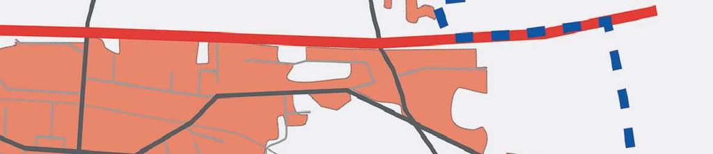
6 WHY CITIES NEED SUSTAINABLE PUBLIC REALM? Motor vehicles have become the main mean of transportation and it is occupied most of our public realm. It has been prioritized over the human movement where the design of streets comes rst. During recent decades, the design of the public realm has provided more noise, pollution, less convenient to move around and you are not encouraged to walk, bike, meet or play. A well-designed public realm should start with people movement and prioritized their social activities by creating various public spaces in terms of size and function. The small intimate in-between places are as important as the large ones. Large size places would allow for big events to take place and small places encourage people to meet when they commute. Parks and gardens consider the heart of the city which offer a variety of green public spaces for people to enjoy and provide major environmental bene ts. I have come into a conclusion after my research about the public realm that the core of cities is its public spaces where the social life exist and these places are vital for democracy. In the public realm, you are free to play, to sit, to walk, To bike, to sleep, to meet, to speak, to demonstrate, to watch, and you do not need to pay, while you will have a sense of being part of the community. The photo is taken in Fredsgatan in Göteborg at night. It shows how the intimate place encourage walkability. The photo shows how the street 111 which becomes the main barrier before the enterance of the city center in Höganäs. It is very dif cult for pedestrians and cyclists to cross, while it is very convenient for cars! Höganäs city provides a public place for dogs where people can rest their dogs free
7 ACTIVITIES IN THE PUBLIC REALM According to Jan Gehl, activities in the public realm can be classi ed into three categories: Necessary Activities Optional Activities Social Activities Necessary Activities are more compulsory, such as walking to work, going shopping, going to school and waiting bus, where people have no other option. This could include every day tasks and the quality of the physical environment has less in uence on theses activities. Optional Activities are recreational and fun, such as, sitting, reading, walking for fresh air, and sunbathing. It depends on exterior physical conditions. These activities are most likely to happen when weather and place are inviting. It is highly dependent on the quality of the physical environment. The relation between the Public realm and Activities (Gehl, 2010) Social Activities are all type of communication between people. It depends on the existing of other people in the public place. It includes children at play, conversations and greetings
8 WHY OLD CITIES ARE MORE ATTRACTIVE? We have better technology, but less attracive cities! According to Alain de Botton from the London School of Life, only a few cities in the world are truly beautiful and none of them built in the recent history. He stated that there is six fundamental things a city needs to get right. 1. Not too chaotic, not too ordered Cities have to seek order and variety to achieve organized complexity. One of the examples of organized complexity can be clearly seen in Amsterdam where the buildings designed to have the same width and height, but different roof types, form and color (de Botton, 2015). Lomma Bibliotek created a wonderful seating places next to water where people could enjoy the sea view and read. The situation encourage the social activities. The photo is taken from Höganäs Museum, illustrates how the small public spaces are important, where it promotes the social activities and create intimate places

.")


9 3. Compact Cities have to be well ordered and highly integrated. Compact cities have high density, mixeduse development and high quality services. Urban designers recently focus more on avoiding urban sprawl, reducing energy consumption, lower emissions and at the same time providing a higher quality of life (de Botton, 2015). Order and variety crates different experience while we cross each house, but at the same time we feel the place is very well organized. 2. Visible Life Many of the modern cities have crated dead streets which looks dark and formed with huge traf c lanes. The life takes place inside the buildings where the public life is less emphasized. As a contrast, the livable streets have more transparent where we can see shops, markets and balconies where people interact with each other and with buildings. This is to say that we need to build for both beauty and practicality at the same time (de Botton, 2015)
10 4. Art of the square 5. Orientation and mystery Cities should provide a balance between big boulevards and small streets. Many of the new developments have prioritized motor vehicles over humans. Cities should be easy to navigate. The big boulevards provides good orientation while back streets and small lanes create a sense of mystery and exploration. It is lovely to get lost! (de Botton, 2015)
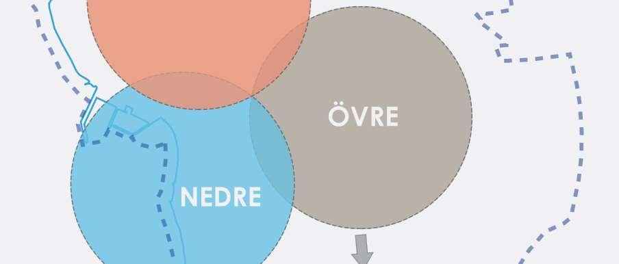
11 6. Scale Most of the recent developments have focused on creating big scale buildings. People tend to focus on who own land and forgot to focus on who own the space and have air rights. Alain de Botton, recommended that above ve- story building height, people will start to feel small (de Botton, 2015). INTRODUCTION TO HÖGANÄS Höganäs municipality is located on the Kullen peninsula in the northwestern part of Skåne region. The municipality consists of seven urban areas (Höganäs, Lerberget, Brunnby, Jonstorp, Väsby, Viken & Farhult) with small community of inhabitants. Höganäs city consider the main center for the municipality which has experienced a rapid growth in population by 50% over the past three decades. Over the past ve years, housing production in Höganäs has been among the highest in Skåne regain, relative to population size. Around 600 housing units have been built and more than half of it as apartment buildings (Höganäs i siffror & stapler, 2016). The start of the urban settlement in Höganäs back to the 15th century as a small shing village. The shing community consisted of 20 household which called Höganäs Nedre. Later on the discovery of a big coal mine in the eastern part of Höganäs has transferred the city into a mining and ceramic industry which known as Höganäs Övre. Today Höganäs AB considers the world leading manufacturer of metal powders. The company employed 1,878 professional and reported sales of SEK 7,590 million in The most urban development took place between 1930s and 1970s. In 1936, Höganäs received the city right and started its municipality (municipal community). The city developed fast and built more schools, water tower, re station, healthcare center. The city started to expand in all direction with large-scale urban development. The fast urbanization took place in three different places which developed overtime and joined together to form the existing physical city structure. As a result, it became very dif cult to determine the city center. 7. Make it local According to de Botton, buildings should not look the same everywhere as cities needs to preserve its identity and culture. Cities needs to have strong characters in terms of materials and forms. The architecture designs should respond to the city s culture, climate, history and traditions


 Variety of")

12 HÖGANÄS IN EUROPEAN CONTEXT The world s leading metal powders producer One of the oldest settlement in Sweden back to Stone Age 60 km long Coast Attractive swimming beaches for Europeans Direct trains from Berlin to Mölle! (were function) Variety of Natural & Cultural Attractions Dramatic landscape (0-190m experience) 23 24


13 HÖGANÄS IN ÖRESUND REGION HÖGANÄS IN HELSINGBORY FAMILY Öresund region consists of Swedish and Danish cities where the region is connected by a 16 km bridge between Malmö and Copenhagen. The region cover an area of total 21,203 square kilometer whit density of 179 inhabitants per square kilometer. The region consists of 33 municipalities in the Swedish side which form the Scania Region and 46 municipalities in the Danish side. In late 2009, decided ten municipalities in the Northwest Skåne to form new organization (Helsingborg Business Region). It is based on collaboration beween eleven municipalities and Höganäs is one of them. The family mission is to persue common issues that bene ts the region. The main aim is to make an effective business process in the area and strengthen the identity of Northwest Skåne as a business and tourist area. The area cover one million square meter. From Helsingborg and within an hour you can reach 3 million people. Öresund region has 3.6 million in habitants. Helsingborg family has over 337,000 inhabitants and consists of eleven municipalities
14 HÖGANÄS MUNICIPALITY Höganäs municipality is one of 290 municipalities of Sweden located on the Kullen peninsula in the northwestern part of Skåne region. The municipality consists of seven urban areas (Höganäs, Lerberget, Brunnby, Jonstorp, Väsby, Viken & Farhult) with small community of inhabitants. Höganäs city consider the main center for the municipality which has experienced a rapid growth in population by 50% over the past three decades. The north part of Höganäs is local nature reserve which sits on a hill called Kullabery. The area reach a maximum height of meter above the sea level and consider on of the most attractive nature in the region. Photo by Alf Petersson( for Höganäs former railway station which is used by Höganäs municipality. Höganäs Municipality Total Area km² Density 180,12/km² * Land km² * Water 0.38 km² Höganäs municipality located in the old railway station building which completed in 1919 and it was planned to replace the two old railway stations in Höganäs Övre and Höganäs Nedre. The place considers today as an important transportation node where the bus station exist

15 DYNAMIC LANDSCAPE EXPERIENCE OF HÖGANÄS The municipality area has a dynamic landscape experience which formed over the last ve centuries. In order to understand the uniqueness of the landscape, a very deep look into the history is very fundamental. Höganäs is a peninsula which bordered by water on three sides. The landscape encompasses sandy beaches, farmlands, industrial area, city center, small rural areas, steep slopes, deep caves and very high hill in Kullaberg which rises above the sea level at 187.5m. Kullaberg nature reserve provides wide range of adventure and relaxation activities from climbing, costal hiking to diving. 190 Meter of Different Experiences 29 30


16 HÖGANÄS HISTORICAL MOVEMENT Fishing Mill Society Fishing Society Höganäs City Municipality Social Sustainable Village was formed was formed Municipality Uni cation Activities Development Population Growth in Höganäs 31 32


17 HÖGANÄS CITY - DEVELOPMENT OVER TIME Started the production of ceramic appliances, bricks and roo ng tiles which heated by extracted coals from mines. Industrial community in Höganäs formed its own mill society and left Väsby socken. Extend the railway to Mölle which make it possible for direct trip from Mölle to Berlin! Höganäs received the city right and started its municipality, municipal community.(united) 33 34


18 Big scale housing development Municipality Uni cation (Höganäas, Väsby, Viken, Brunnby and Jonstorp). The current municipality was reformed. The end of using the railway. Höganäs become the Central place. Kullagymnasiet open (High Scool) in 1999 Höghuset (residential tower). 44 m height landmark building 15 story building next to the water


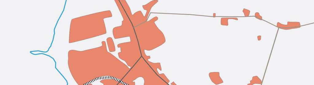
19 HISTORY OF THE PUBLIC REALM IN HÖGANÄS GRUVTORGET (Mine Square) In 1797, started the coal mining industry which lasted for 150 years. In early 1800s, a large coal mine was found in the east of Höganäs and the mining community Ryd started to form Höganäs Övre. The mining community started the town plan in 1802 for Ryd with mining square (Gruvtorget) and small retail center. The center developed over time with more shops, administrative buildings, post, hospital, and housing which became the main center for Höganäs Övre. A water channel excavated to transfer water from the harbor to the mine in Ryd. Storgatan is the street which connect Gruvtorget to the harbor was the path for the water channel. Storgatan Wooden Bridges over the water channel in Storgatan Gruvtorget STORGATAN Water Channel GRUVTORGET (Mine Square) 37 38

 with new hotel (Schweiz resturant), dance hall")

20 SUNDSTORGET (Fishing Square) In 1880, the shing market ourish because of the growing demand on sh by the mining community. A new houses were built next to the harbor and the shing community start to form their own square (Sundstorget) with new hotel (Schweiz resturant), dance hall with theater venue (Sagabiografen) built in Sundstorget become the main entertainment center in Höganäs Nedre. Sundstorget SUNDSTORGET-1880 (Fishing Square) GRUVTORGET (Mine Square) 39 40


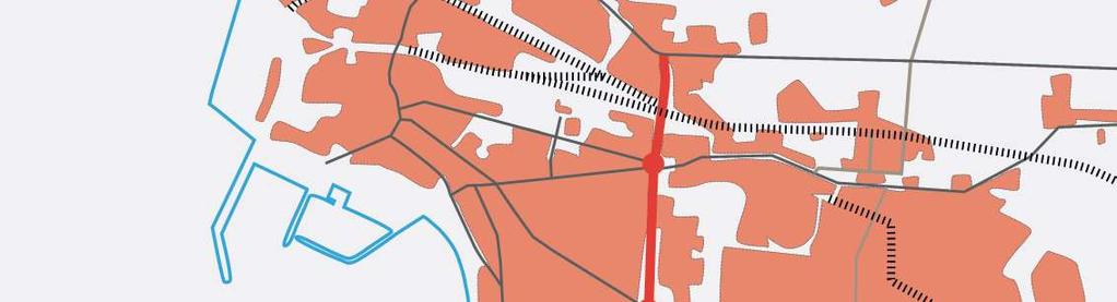
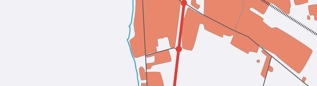
21 JÄRNVÄGSSTATIONEN (Buss Square) In 1919, the shing community left Väsby socken and united with Höganäs industrial parish to form the municipality. The new train (JÄRNVÄGSSTATIONEN) station completed and the other two stations in Övre and Nedre closed. The new plan focused on bringing both communities together. The new square ourish (Busstorget) with the buss station and become an important node where Höganäs Municipality is today located. JÄRNVÄGSSTATIONEN-1919 (Buss Square) Höganäs Municipality - Busstorget SUNDSTORGET-1880 (Fishing Square) GRUVTORGET (Mine Square) 41 42
 The new city church")
 with")


 Photo by world")

22 HIMMELSFÄRDSYRKAN (Church Square) The new city church which was built in 1932 (Himmelsfärdsyrkan) with small square after the formation of Höganäs Parish in It was designed by Ivar Tengbom. Kyrkplatsen JÄRNVÄGSSTATIONEN-1919 (Buss Square) Photo by world travel images - Flower Market SUNDSTORGET-1880 (Fishing Square) KYRKPLATSEN-1932 (Church Square) GRUVTORGET (Mine Square) 43 44


23 TRIANGELPLATSEN (Triangle Square) In 1960S, more traf c development was prioritized in response to the increased number of cars. The railway stopped operation completely in The last railway in the left photo is removed in 1997and the pedestrian bridge is kept and rebuilt. Triangelplatsen JÄRNVÄGSSTATIONEN-1919 (Buss Square) Triangelplatsen SUNDSTORGET-1880 (Fishing Square) KYRKPLATSEN-1932 (Church Square) TRIANGELPLATSEN 1960s (Triangle Square) GRUVTORGET (Mine Square) 45 46

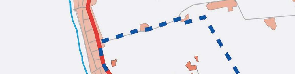
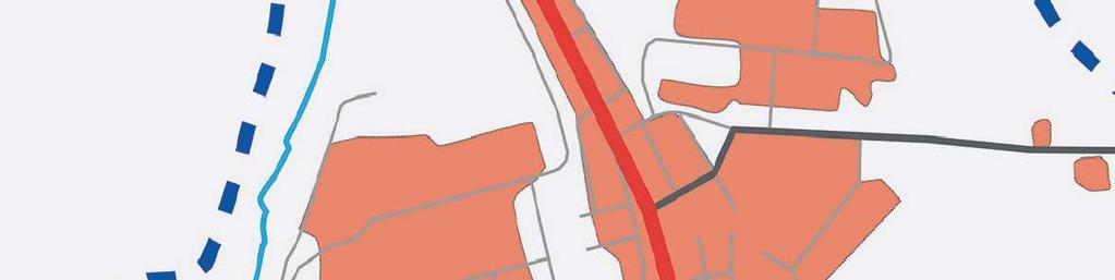
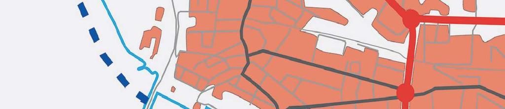
24 CITY ANALYSIS Topography The city has almost at topography in the southern part, while in the north the height of the landscape is gradually increase. All the landscape has a slop from +10 meter above the sea level from the north eastern part towards the sea side. The Landscape creates a wonderful opportunity for water management where the storm water could be collected and directed to the sea. Traf c Flow The city has two main streets 111 which connect the city to Helsingborg and 112 in the direction of Ängelholm. The road 111 consider the main barrier in the city where it is over dif cult to cross over and lack bike and pedestrian path. The idea of directing all the trucks towards the road 112 could be a great solution to free the road 111 and the new proposed center from emissions. Providing pedestrian and bike paths are important for the future sustainable development

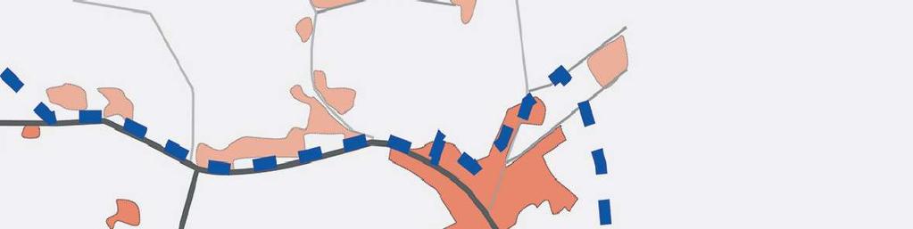
25 CITY ANALYSIS Buss Stops within 5 minutes walk (400m) More than 3000 people commute from Höganäs and almost 1000 people travel to Höganas every day. The road 111 curries around 3 million bus trip every year to Helsingborg. The idea of providing tramway is very in the future is very important for reducing the number of trips and emissions. The idea of providing better connection to Helsingborg will have signi cant impact on the prosperity of the city. Public Activities Most of the activities occur during the summer and next to the sea. The sport activities are gathered in the southern part and formed Höganäs Sport Center. There is a need for connecting the activities and provide better public system. The public squares is not really active, but still it is very important for telling the history of Höganäs. The active green spaces are shown in green color in the above diagram while there is a need for connecting and activating the rest of green areas to provide a green loop


26 REGIONAL STRATEGY BRANDING HÖGANÄS IN ÖRESUND REGION 2050 From Helsingborg and within an hour you can reach 3 million people. Öresund region has 3.6 million inhabitants. Changing Höganäs Location into a DESTINATION! To Promote Existing Qualities The Rich History Sustaible Living The Spirit of Höganäs To Attract Tourists New Businesses Younger Generation To Generate Sense of Proud Staibale Economy 51 52
27 HÖGANÄS CITY STRATEGY The City Main Strategies Develop new center: The new center will provide sense of orientation and promote public activities Densify around the center : Avoiding urban sprawl, while providing mixed-use in ll in respect to the existing urban structure. Create gateways: Strengthen the city entrances where people feel more welcome and feel that they enter the city. Strengthen the connection to water: Connect people to the water by water stream which strengthen the identity. The stream could function as a drain for the whole city. Promote walking and cycling: Providing the necessary infrastructure for encouraging safe environment for people to walk and cycle
28 SITE STRATEGIES CONNECT HÖGANÄS The strategy will focus on linking the isolated two parts of the city togethwe and promoting public transportation. It will increase the number of trips made by foot and bike. The main streets will be transferred into green corridors. GREEN LOOP The green loop will link the green and urban public spaces together while providing new life experience to the city center. The loop will promote walking, cycling and jogging and thus will enhance the health of Höganäs. It will create new public spaces while linking the green structure and make it active and accessible
29 GREEN SYSTEM The green structure and the water front will strengthen the image of Höganäs as blue and green city. It will provides access to the nature through different green qualities by the water and inside the city. The natural home for ora and fauna is very well connected and consider the green heart of the city. DEFINE THE CENTER The connected center will focus more on telling the history of Höganäs and how the public realm developed over time. The proposed center will strengthen the identity and the sense of orientation while entering the city. The urban public spaces will function in parallel with the green structure in a very beautiful harmony. Connection to the water is emphasized through two main access which connect together through Köpmansgatan (street)
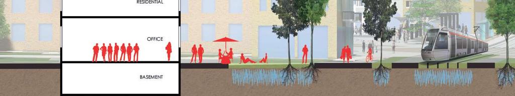
30 WATER MANAGEMENT The historical water channel which excavated to transfer water from the harbor to the mine in Ryd is no more exist. The strategy of bringing back the water stream is very important for the storm water management, telling the history of the city, and strengthen its identity. Connect to the water by water.. CONNECTED PUBLIC SYSTEM The public system is a combination of all the strategies where the city will provides very well connected public realm with more recreational facilities. Höganäs will become the most eco-friendly city in the region
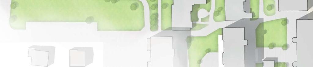
31 DESIGN PROCESS MASTER PLAN The design process is based on the following steps: 1. Tracking The rst step focus on registering the movement and the ow of people. This includes people s speeds and which way they prefer to take. Then it will be followed by a proposal for the new movement which will help to clearly show the pedestrian and cyclist connections. The master plan is developed based on the site strategies focusing on the area of 2.5 square kilometer as shown below. The main focus is the new city center and the city garden. The city center has been given more priority in terms of design, while the city garden consider a complement part and also important for the contribution to the new proposed center 2. Mapping In This step we draw the people s activities on map, such as, where people sit, stand, talk and other. It helps to understand how people interact with the space. It also include a proposal for new activities where we start the design with creating new people activities. City Garden 3. Activating The stage where the spaces is decided to be activated based in the proposed new activities. The relation between spaces and dimensions is considered. Places to sit, play, talk, stand and eat. City Center 4. Forming The densi cation with buildings which form the space and create a street life at the pedestrian level. The new buildings have to respect the existing ones in term of height, solar access, views and material. It should help to form small in between spaces, as well as, private realm. Mater plan area of 2.5 square kilomete 5. Testing Testing the thermal comfort of the space in terms of solar access, wind simulation and storm water management. The forming stage will be adjusted to provide the thermal comfort


32 MASTER PLAN N 63 64
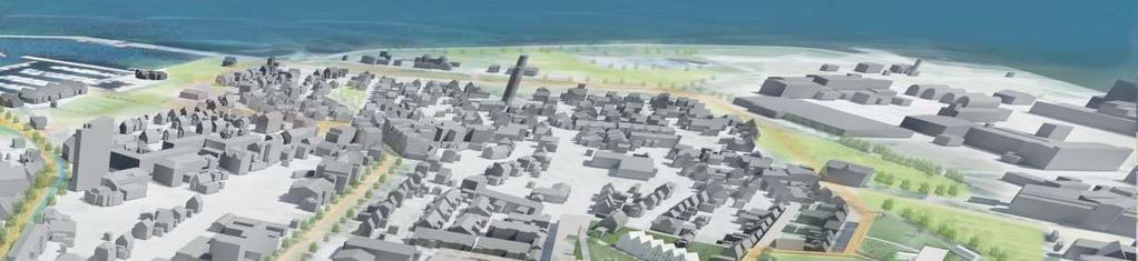


33 Axonometric view for the master plan Shows the new center connections to water and to the city garden 65 66
34 DETAILED AREA 1 - CENTRAL SQUARE Existing petrol station. Seven-story residential building 67 68


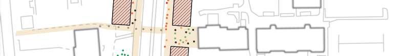
35 1. Tracking The existing movement shows how it is dif cult to pass the main street 111. The streets have been designed mainly for cars which limited the people s movement. The new proposal focus more on the pedestrian ow providing more connection. This includes the bike lanes
36 2. Mapping The activities that people perform are almost standing, watching and talking. There is no other activity is performed. The people observed for 2 weeks from 8:00 to 17:00 in different days The proposed activities are siting (Green), shopping (Red), Play with water or skating (Blue), talking (Black), standing and watching (Orange)


37 3. Activating 4. Forming The activities that people perform are almost standing, watching and talking. There is no other activity is performed. The people observed for 2 weeks from 8:00 to 17:00 in different days The activities that people perform are almost standing, watching and talking. There is no other activity is performed. The people observed for 2 weeks from 8:00 to 17:00 in different days 73 74
38 6. Transportation The activities that people perform are almost standing, watching and talking. There is no other activity is performed. The people observed for 2 weeks from 8:00 to 17:00 in different days 75 76
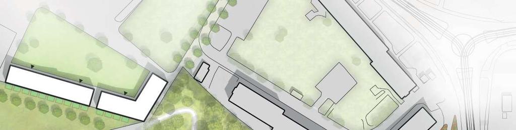
39 EXISTING SITUATION PROPOSED DETAILED PLAN - CENTRAL SQUARE 77 78


40 DETAILED PLAN - CENTRAL SQUARE N A B C A B C 79 80


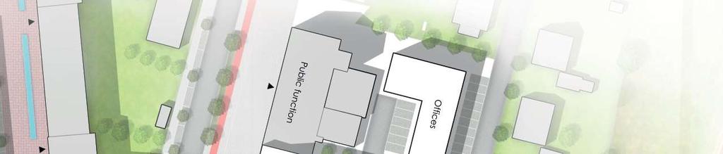
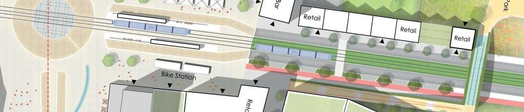
41 BIRD S EYE VIEW- CENTRAL SQUARE The new square accommodates the tram station and become the center of Höganäs which orient the visitors towards the museum area and to the sea


42 SECTION A-A SECTION B-B 83 84


43 SECTION C-C The historical water channel which excavated to transfer water from the harbor to the mine in Ryd is no more exist. The strategy of bringing back the water stream is very important for the storm water management, telling the history of the city, and strengthen its identity. Connect to the water by water


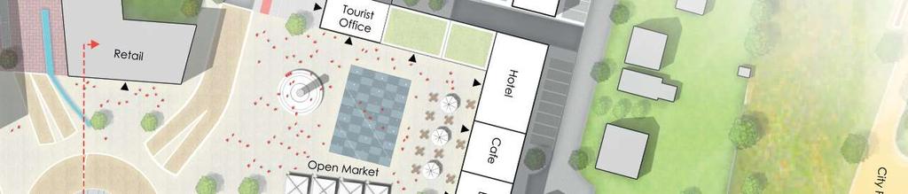
44 The main square conatins ERIC RUUTH statue as landmark, Höganäs Hotel, Ice skating, BAR, Tourist of ce, Open market,and Retail


45 Transparent bridge, green connection to the square, 2 lanes cycle path, permeable paving, open view to the new development, welcoming gate 89 90

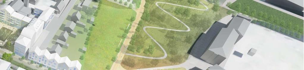
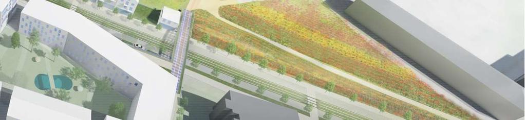
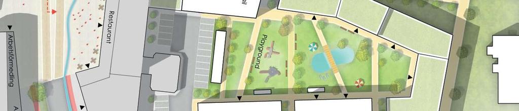
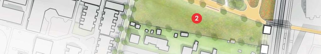
46 DETAILED PLAN AREA 2 CITY GARDEN The city Park in Höganäs is part of the proposed green network which aim to make the city more accessible to nature and more attractive. The green loop provides a green connections which welcome citizens and visitors to walk. It creates a memorable experience from the welcoming owers rise, through the forest and ending with Animals Park. Different experiences with all senses create a relation between people and spaces. Places where people want to spend more time in the community. Providing Connections to the city center and to other part of the city. 1. Tracking The garden is divided into smaller spaces which create different quality. The spaces provides different experience and feeling where it create memories in the following nine spaces: 1. ROMANTIC FLOWERS RISE: Brings welcoming feeling 2. MULTIFUNCTIONAL SPACE: Freedom Feeling 2. Activating 3. FOREST EXPERIENCE: Adventure feeling 4. GREEN AND WHITE STAGE: Excitement feeling Divide the garden into smaller spaces with different qualities and experience. 5. SPORT AND PLAY: Feeling energetic 6. AGRICULTURE : Feeling productive 7. AQUATIC EXPERIENCE: Relaxing feeling 8. Dogs Park: Friendly feeling 9. ANIMALS PARK: Friendly feeling 3. Forming Form the space with buildings and hide some of the big industrial buildings


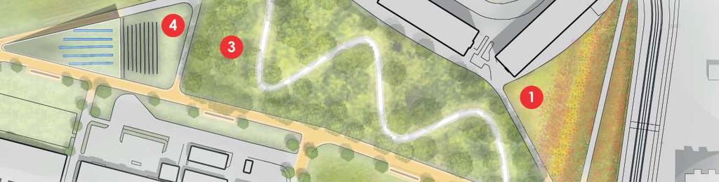
47 DETAILED PLAN - CITY GARDEN N 93 94
48
49 REFERENCES 7 Björkman, Jan (1973) Två torg i Höganäs Call to Action, Healthy Communities and Planning for the Public Realm, Ontario Professional Planners Institute, Canada. de Botton, A., How to Make an Attractive City, The School of Life, London Fraker, H., The Hidden Potential of Sustainable Neighborhoods: Lessons from Low-Carbon Gehl, J., Cities for People, DC Island Press, Washington. Gehl, J., & Svarre, B., How to Study Public Life, DC Island Press, Washington. Höganäs i siffror & stapler., 2016., Samhällsbyggnadsförvaltningen, Höganäs Höganäs Municipality, 2002, Översiktsplan för Höganäs kommun ÖP 2002, Höganäs, Sweden Höganäs Municipality, 2012, Fördjupning av Översiktsplanen för Höganäs och Väsby, Kommun. Höganäs Municipality, 2016, Översiktsplan för Höganäs kommun ÖP 2030, Höganäs, Sweden Miljökonsekvensbeskrivning, Höganäs, Sweden Jacobs, J., The Death and Life of Great American cities, Random House, New York, page: 238. Petersson, A. ( Historical Photos. Ranby, H., Höganäs från stenålder till millennieskifte, Grahns Tryckeri AB, Lund. Woolley, H., Sian, R. & Freedman, J., 2004, The Value of Public Spaces, create economic, social Region Skåne 2014, Adopted by the Regional Council on 17 June 2014, and environmental value, London: CABE spaces Facts About The Oresund Region, Geography,
50 99
York Road Arial View
 Arial View Bridge Ave YORK ROAD THE SITE TODAY View west down View west from View east The 1.5 ha site is located south of the and to the east of Queen Street. The site includes an existing car park, disused
HE VISION. Building a Better Connected Place
 HE VISION Building a Better Connected Place WALK INTO THE FUTURE. Life in Cranberry, 2030 Here s what our residents told us they wanted to see in their community by 2030: The Cranberry of 2030 is a place
A Vibrant Downtown. Chapter 5 Cary Public Art Opportunities 31
 A Vibrant Downtown Cary s vision for Downtown is a unique, vibrant, dynamic, pedestrian friendly location; a regional destination and a place to live, work, and recreate, according to the 2001 Town Center
City of Farmington. Downtown Plan. Amendment to the 1998 Master Plan Adopted October 11, 2004
 City of Farmington Amendment to the 1998 Master Plan Adopted October 11, 2004 Introduction Planning Background 1 Scope and Components of the Plan Amendment 2 Concept Introduction 3 Plan Concepts 3 Conceptual
4- PA - LD - LIVELY DOWNTOWN. LD - Background
 4- PA - LD - LIVELY DOWNTOWN LD - Background The downtown has been the service centre for the community since the city s inception and the area continues to supply people with their personal services,
Neighborhood Districts
 NEIGHBORHOOD DISTRICTS SEVEN MAIN DISTRICTS Neighborhood Districts While the Development Plan provides a broad-scale overview of the neighborhood, this section focuses on uses and relationships at the
Colchester Northern Gateway Master Plan Vision Review Draft. July 2016
 Colchester Northern Gateway Master Plan Vision Review Draft July 2016 Contents Introduction 4 Context 8 Purpose of the Report 8 Strategic Position 9 Overview of the Process 11 2012 Master Plan Vision 12
WELCOME and introduction
 1 WELCOME and introduction Mobility Hub Locations within Burlington STUDY OVERVIEW STUDY OBJECTIVES The City of Burlington is developing four Area Specific Plans, one for each of Burlington s Mobility
New-Cast Mixed-use Development Proposal King Street West, Newcastle, Ontario
 URBAN DESIGN BRIEF New-Cast Mixed-use Development Proposal King Street West, Newcastle, Ontario TABLE OF CONTENTS: 1.0 Executive Summary 2.0 Creating Vibrant and Sustainable Urban Places: Excerpts from
NORTH LAKE SPECIFIC PLAN AREA
 NORTH LAKE SPECIFIC PLAN AREA June 21, 2018 WELCOME Workshop Agenda Introduction Provide information about the program and introduce the team Background Information Share information about the North Lake
Mix of Uses Guide for Transit-Oriented Development MIX OF USES
 MIX OF USES Creating a Destination Magnet A diversity of uses such as retail, housing, offices, civic and entertainment within the TOD creates a destination magnet for transit users and TOD neighbors.
Town Center (part of the Comprehensive Plan)
") Town Center (part of the Comprehensive Plan) Mercer Island Town Center Looking North (2014) In 1994, a year-long process culminated in a set of design guidelines and code requirements for the Town Center
Town Center (part of the Comprehensive Plan) Mercer Island Town Center Looking North (2014) In 1994, a year-long process culminated in a set of design guidelines and code requirements for the Town Center
V. Vision and Guiding Principles
 V. Vision and Guiding Principles The Master Plan for the Powers Ferry Corridor seeks a foundation in the desires of the community. At times, various elements of the community offered opposing viewpoints,
Sustainably Repositioning Greyfield Sites. Greyfield Sites Anywhere
 Sustainably Repositioning Greyfield Sites Jim Constantine Looney Ricks Kiss Architects Todd Poole 4ward Planning Greyfield Sites Anywhere Pennsylvania Chapter American Planning Association Conference 2009
Welcome to the Oakridge Centre Open House
 Welcome to the Oakridge Centre Open House Why is the City hosting this event? This open house is to inform you of a rezoning application submitted to the City of Vancouver to amend the existing CD-1 (Comprehensive
2.1 Location and Size
 2.0 Context 7 2.1 Location and Size The Saanich Penninsula The study area is centrally located within the Town boundaries on the east side of Highway 17, which runs through Sidney in a north-south direction.
CAMBIE CORRIDOR PLAN
 1 WELCOME TO THE OPEN HOUSE PUBLIC REALM PLAN - CAMBIE CORRIDOR Thank you for coming to the Cambie Corridor Public Realm Open House! Place a dot where you live Please provide us with your comments and
3.1 community vision. 3.3 required plan elements
 Chapter 3 Community Form 3.1 community vision 3.2 Parks & landscaping concepts 3.3 required plan elements D R A F T 20 Community Form Chapter 3 3.0 Community form 3.1 community vision The Specific Plan
4 C OMMUNITY D ISTRICTS
 4 C OMMUNITY D ISTRICTS N ew development in the Area will include many different types of land uses, including a destination retail area that attracts people from all over the region; recreation opportunities
ELK GROVE GENERAL PLAN VISION
 2-1 CHAPTER 2: 2-2 CREATING OUR The Community Vision for Elk Grove, expressed through a Vision Statement and a series of Supporting Principles, is a declaration of the kind of community that Elk Grove
2.0 THE PLATINUM TRIANGLE VISION
 2.0 THE PLATINUM TRIANGLE VISION The envisions an exciting future for the area surrounding Angel Stadium of Anaheim, the Honda Center and The Grove of Anaheim. 2.1 Planning Principles In order to further
THE CIVIC DISTRICT DEVELOPMENT OPPORTUNITIES
 1 THE CIVIC DISTRICT DEVELOPMENT OPPORTUNITIES The Civic District is the physical and emotional heart of the downtown. It is also a major gateway into the central core, establishing the image and identity
QUESTION 8: What are your Public Realm priorities for implementation? What would you like to see happen first? TELL US WHAT YOU THINK
 Public Realm Plan How will the Public Realm Plan be implemented? The Public Realm Plan document will set out a vision for the next 30 years. Over time, Plan elements and aspects can be implemented as opportunities
Urban Design and Livability
 Urban Design and Livability City of Sacramento Planning Academy April 6, 2015 Bruce Monighan AIA Urban Design Manager, City of Sacramento How do we define cities in their characteristics of livability?
Downtown North Las Vegas Demonstration Site Project. Project Update
 Downtown North Las Vegas Demonstration Site Project Project Update 7.16.14 Presentation Overview Project Purpose and Process Planning Context Opportunities and Barriers Summary Community Input Preliminary
Proposed Reconstruction of Cleveland s Public Square
 Proposed Reconstruction of Cleveland s Public Square This information packet describes a proposed reconstruction of Cleveland s Public Square. The purpose of the reconstruction is to make Public Square
3.1 Existing Land Use
 3.0 Land Use This strategy has been developed taking into account the position of the Town of Sidney as the economic center of the Saanich Peninsula. It acknowledges existing land use patterns in the downtown
THEMES, VISION, + PRINCIPLES
 CHAPTER 2: THEMES, VISION, + PRINCIPLES This page intentionally left blank. 20 VISION DRAFT AUGUST 2018 2 2 THEMES, VISION, + GUIDING PRINCIPLES The Key Themes, Vision, and Guiding Principles presented
A PATTERN LANGUAGE (Christopher Alexander) List of Patterns 1. INDEPENDENT REGIONS 2. THE DISTRIBUTION OF TOWNS 3. CITY COUNTRY FINGERS
 List of Patterns 1. INDEPENDENT REGIONS 2. THE DISTRIBUTION OF TOWNS 3. CITY COUNTRY FINGERS") A PATTERN LANGUAGE (Christopher Alexander) List of Patterns 1. INDEPENDENT REGIONS 2. THE DISTRIBUTION OF TOWNS 3. CITY COUNTRY FINGERS 4. AGRICULTURAL VALLEYS 5. LACE OF COUNTRY STREETS 6. COUNTRY TOWNS
A PATTERN LANGUAGE (Christopher Alexander) List of Patterns 1. INDEPENDENT REGIONS 2. THE DISTRIBUTION OF TOWNS 3. CITY COUNTRY FINGERS 4. AGRICULTURAL VALLEYS 5. LACE OF COUNTRY STREETS 6. COUNTRY TOWNS
Exploring a new student life through the buildings in Bovisa. Zahra Ziaee Lorzad. Mc. Politecnico di Milano, 2014
 Exploring a new student life through the buildings in Bovisa By Zahra Ziaee Lorzad Mc. Politecnico di Milano, 2014 1 Problem statement The thesis questions the role and mutation of architecture in the
greenprint midtown SUSTAINABILITY ACTION PLAN 2012
 greenprint midtown SUSTAINABILITY ACTION PLAN 2012 MIDTOWN ALLIANCE SOUTHFACE ENERGY INSTITUTE RENAISSANCE PLANNING GROUP SUSTAINABLE ATLANTA PERKINS+WILL 2 GREENPRINT MIDTOWN 1. Introduction Sustainability
Create Policy Options Draft Plan Plan Approval. Public Consultation Events. Phase 2
 Background Grandview-Woodland Community Plan In the spring of 2012, the City of Vancouver embarked on a comprehensive community planning program in the Grandview-Woodland neighbourhood. The process has
1 October Dear Citizens of Charlotte and Mecklenburg County,
 1 October 2011 Dear Citizens of Charlotte and Mecklenburg County, As co-chairs of the Center City 2020 Vision Plan Steering Committee, we are proud to present the Center City 2020 Vision Plan, which sets
the multilayered, fragmented Trianglen station
 Movement & pause the multilayered, fragmented Trianglen station TOWARDS CITY CENTRE THE LIVING KNOT FUTURE MALMÖ CONNECTIONS trianglen is the new main underground train gateway to the greater Öresundregion
 Health Sciences City The available land area, although limited, combined with the unique partnership between the primary institutions and the supporting partnerships of the development interests within
The Master Plan Framework
 The Master Plan Framework The East Harbour Master Plan advances the development of 60 acres of former industrial lands east of the Don River. The Master Plan outlines a vision for a vibrant, transit-oriented
Title: South Britannia Community Centre Tobi Fenton
 Title: South Britannia Community Centre Tobi Fenton South Britannia is laid out in a grid of 120x60 meter blocks with Main Street oriented towards Howe Sound. The concentrated centre is located at the
Charles Eames Artist Studio AN APPLICATION OF PATTERN LANGUAGE TO THE ENTRANCE
 Charles Eames Artist Studio AN APPLICATION OF PATTERN LANGUAGE TO THE ENTRANCE MICHELLE HAY D263 DESIGN METHODS SPRING 2014 Contents 1 2 3 INTRODUCTION BACKGROUND CASE STUDY 3 4 12 INITIAL PLAN DESIGN
EXISTING COMPREHENSIVE PLAN
 EXISTING COMPREHENSIVE PLAN Town Center Land Use Element: V. LAND USE POLICIES Town Center Mercer Island's business district vision as described in "Your Mercer Island Citizen-Designed Downtown" was an
This Review Is Divided Into Two Phases:
 Semiahmoo Town Centre Review The purpose of this review: To review the Semiahmoo Town Centre Concept Plan, originally approved in 1993, to ensure that this centre will continue to serve the needs of South
ANCHOR TO ANCHOR. Rescale the street to create an iconic boulevard.
 ANCHOR TO ANCHOR Rescale the street to create an iconic boulevard. UR NE ER UV GO NE LA OBJECTIVES 1. Maintain appropriate traffic flow and prioritize commercial curb access 2. Mark gateways at the street
How can we improve mobility and access?
 How can we improve mobility and access? North King s Town is located fairly centrally within the city, but there are still multiple opportunities to improve mobility within the study area, including connections
Section 1 Introduction
 Section 1 Section 1,, describes the role of the Official Plan. The Official Plan is one of five growth management plans that was completed under the umbrella of Ottawa 20/20. 1.1 The Role of the Official
The urban block as a potential for sustainable urban design
 The Sustainable City X 69 The urban block as a potential for sustainable urban design M. Oikonomou Department of Urban Planning and Regional Development, Aristotle University of Thessaloniki, Greece Abstract
Port Lavaca Future Land Use
 Port Lavaca Future Land Use Introduction The City of Port Lavaca is beginning to see sustained growth, after many years of relative stable population. New single family homes, apartments, and businesses
LAND USE AMENDMENT DOWNTOWN COMMERCIAL CORE (WARD 7) MACLEOD TRAIL SE AND 5 AVENUE SE BYLAW 254D2017
 MACLEOD TRAIL SE AND 5 AVENUE SE BYLAW 254D2017") Page 1 of 10 EXECUTIVE SUMMARY This Land Use Amendment application seeks to redesignate a full downtown block (currently the YWCA site) from a Direct Control based on the CM-2 District (Land Use Bylaw
Page 1 of 10 EXECUTIVE SUMMARY This Land Use Amendment application seeks to redesignate a full downtown block (currently the YWCA site) from a Direct Control based on the CM-2 District (Land Use Bylaw
One of the components of the sustainable, traditional neighborhood is the neighborhood center.
 One of the components of the sustainable, traditional neighborhood is the neighborhood center. The neighborhood center defines a community s identity and is the place for events, leisure activities, public
Silverdale Regional Center
 Silverdale Regional Center Vision for Silverdale Regional Center The Silverdale Regional Center Plan (Plan) will guide the evolution of the Silverdale Regional Center from a collection of strip malls and
THE NEIGHBORHOOD TODAY
 THE NEIGHBORHOOD TODAY CORE AREA VISION How are we Good Urbanism A Site s DNA thinking about Elements of great Unique elements urban communities embedded in a place the site and design? ELEMENTS LIKE:
Town Center. Block 5 Existing multifamily residential units are expected to remain.
 Area Guidelines Germantown s districts should be developed as distinct communities with unique features that are supported through the guidelines. The guidelines not only help distinguish these districts
Improving life on Megacities in developing countries through public interconnected spaces. David Fernandes Felício
 Social Public Life Improving life on Megacities in developing countries through public interconnected spaces David Fernandes Felício When public spaces are successful [ ] they will increase opportunities
Good education Good living Green future
 D66 Groningen - english summary of the election programme - 2018-2022 Good education Good living Green future Together we make Groningen Highlights 2 Groningen has many things to offer: a vibrant cultural
SECTION ONE: INTRODUCTION. introduction
 introduction 1 INTRODUCTION Since it was first established in 1843 as a trading post for the Hudson s Bay Company, Victoria has evolved into a Provincial capital city that is recognized across Canada and
Inspiring Technovation
 1 2 Table of content List of table and figures... Executive summary... 1. Introduction... 2. Material and methods... 3. Results... 3.1 Today s facts about Versailles: a diagnostic approach... 3.1 Vision
Robbinsdale LRT Station. CDI Development Guidelines. August Overview
 Robbinsdale LRT Station August 2018 Overview The City of Robbinsdale may have the coolest opportunity site along the 13 mile stretch of the Bottineau LRT corridor / Blue Line extension. Located a block
Plano Tomorrow Vision and Policies
 Plano Tomorrow Vision and Policies PLANO TOMORROW PILLARS The Built Environment The Social Environment The Natural Environment The Economic Environment Land Use and Urban Design Transportation Housing
Lambeth Main Street Streetscape Improvements
 Lambeth Main Street Streetscape Improvements Open House October 5th, 2017 Agenda 1. Introduction 2. Project Background 3. Context 4. Project Objectives 5. Design Principles & Approach 6. Streetscape Design
Heads up Versus Heads Down Retail: the missing link between good public spaces and good markets?
 Heads up Versus Heads Down Retail: the missing link between good public spaces and good markets? Much can be learned about what makes places great by observing successful markets - and vice versa Project
UNION STUDIO Greater Kennedy Plaza!
 April May 2013 UNION STUDIO Greater Kennedy Plaza! It s time: Providence s civic plaza and transit hub is re-imagined as a vibrant urban gathering place 1 Kennedy Plaza Reborn THE TEAM Client: The City
ELMVALE ACRES SHOPPING CENTRE MASTER PLAN
 ELMVALE ACRES SHOPPING CENTRE MASTER PLAN Contents 1.0 INTRODUCTION... 2 2.0 LOCATION... 2 3.0 EXISTING CONTEXT... 2 4.0 VISION & GUIDING PRINCIPLES... 2 5.0 LAND USE AND BUILT FORM... 4 5.1 St. Laurent
REPORT BACK BROADSHEET 3 May 2016
 Paddington Place REPORT BACK BROADSHEET May 06 Architects and planners should work with the community first and then thinking about developers profits second. - Quote from participant at Paddington Place
K. SMART ASSOCIATES LIMITED
 Planning Justification Report Zoning By-Law Amendment 185 King Street North Waterloo, Ontario April 7th, 2017 Project Reference Number 16-245 K. SMART ASSOCIATES LIMITED CONSULTING ENGINEERS AND PLANNERS
2.0 Strategic Context 4
 2.0 Strategic Context 4 2.1 The Area Action Plan is a non-statutory plan, which forms a corporate policy document, expressing particular issues and areas of concern while also providing a vision for the
Chapter 4. Linking Land Use with Transportation. Chapter 4
 Chapter 4 Linking Land Use with Transportation Chapter 4 59 Chapter 4 Linking Land Use with Transportation Community Design and Transportation Program Introduction Since the 1950s, the predominant development
TRANSIT ORIENTED DEVELOPMENT PINELLAS COUNTY MPO LIVABLE COMMUNITIES INITIATIVE PINELLAS COUNTY COMPREHENSIVE PLAN AMENDMENTS
 PINELLAS COUNTY MPO LIVABLE COMMUNITIES INITIATIVE MODEL LAND DEVELOPMENT CODE TRANSIT ORIENTED DEVELOPMENT PINELLAS COUNTY COMPREHENSIVE PLAN AMENDMENTS MPO Livable Communities Initiative Goal: Improve
Sahuarita District & Phase 1 Master Plan. Town Council December 11, 2017
 Sahuarita District & Phase 1 Master Plan Town Council December 11, 2017 Visioning Study Visioning Process Advisory Group Meetings Community Questionnaire Town Center Case Studies Community Analysis The
Northwest commuter rail station US 36 BRT. Westminster Station
 Northwest commuter rail station Westminster Station US 36 BRT Westminster Center US 36 & Church Ranch Broomfield Flatiron/96 th St. US 36 & McCaslin Table Mesa Boulder Junction 13-month effort that will
Engagement Summary Gastown Streets: Local Business Visioning Workshop
 Engagement Summary Gastown Streets: Local Business Visioning Workshop Gastown s streets are in need of major repair and rehabilitation and we have a once in a lifetime opportunity to holistically plan
RELAXED URBAN LIVING AMONGST FRIENDLY FACES
 RELAXED URBAN LIVING AMONGST FRIENDLY FACES A BRIGHT FUTURE FULL OF GROWTH AND OPPORTUNITY At The Hugh, you ll feel the excitement around community growth in the comfort of your modern, open-plan apartment.
ANALYSIS OF PROPOSALS ERIK MØLLER ARKITEKTER KANOZI ARKITEKTER LILJEWALL ARKITEKTER
 ANALYSIS OF PROPOSALS ARKITEKTER ARKITEKTER ARKITEKTER 1 CRITERIA A. CONTINUITY B. EFFICIENCY C. QUALITY D. DIVERSITY E. ACCESSIBILITY How are the connections between adjacent neighborhoods and Region
Urban Design & Placemaking
 Urban Design & Placemaking What is Urban Design? Urban Design is the discipline of creating equitable, vibrant, and sustainable places with distinct identities. The profession pulls from other built environment
COMMUNITY ACTIONS for a SUSTAINABLE BARWON HEADS. February 2016
 COMMUNITY ACTIONS for a SUSTAINABLE BARWON HEADS February 2016 Acknowledgements Traditional Owners We acknowledge the traditional owners of this land and pay our respects to their elders past and present,
Developer s Program. The Station at East 54
 Developer s Program The Station at East 54 Existing Conditions The Station at East 54 is proposed for a 1.12 acre site at the northeast corner of Hamilton Road and Prestwick Road, tucked between the East
Mark-up of the effect of the proposed Bronte Village Growth Area OPA No.18 on the text of section 24, Bronte Village, of the Livable Oakville Plan
 Mark-up of the effect of the proposed Bronte Village Growth Area OPA No.18 on the text of section 24, Bronte Village, of the Livable Oakville Plan Notes: This document is provided for information purposes
[PLANNING RATIONALE] For Site Plan Control and Lifting of Holding Zone By-Law 101 Champagne Avenue. May 23, 2014
![[PLANNING RATIONALE] For Site Plan Control and Lifting of Holding Zone By-Law 101 Champagne Avenue. May 23, 2014](/thumbs/75/71599615.jpg "[PLANNING RATIONALE] For Site Plan Control and Lifting of Holding Zone By-Law 101 Champagne Avenue. May 23, 2014") [PLANNING RATIONALE] For Site Plan Control and Lifting of Holding Zone By-Law 101 Champagne Avenue May 23, 2014 Contents 1.0 Introduction... 2 2.0 Site Context... 2 2.1 Adjacent Uses... 2 Figure 1: Site
[PLANNING RATIONALE] For Site Plan Control and Lifting of Holding Zone By-Law 101 Champagne Avenue May 23, 2014 Contents 1.0 Introduction... 2 2.0 Site Context... 2 2.1 Adjacent Uses... 2 Figure 1: Site
DOWNTOWN GEORGETOWN PLANNING STUDY
 DOWNTOWN GEORGETOWN PLANNING STUDY Community Workshop #3 Thursday, May 4, 08 The Planning Partnership OVERVIEW OF STUDY, PROCESS & MILESTONES We are here PURPOSE OF THE STUDY To develop a clear vision
STUDY OF URBAN SMART GROWTH APPROACH BASED ON THE PRINCIPLES AND GUIDELINES FOR NEW PLANNING
 www.arpapress.com/volumes/vol23issue2/ijrras_23_2_05.pdf STUDY OF URBAN SMART GROWTH APPROACH BASED ON THE PRINCIPLES AND GUIDELINES FOR NEW PLANNING Abbas Matloubi Technical and constructive assistant,
Nader Obied Abd al raheem hathat. Dr. Farid S. Al-Qeeq
 Submit from Nader Obied Abd al raheem hathat Submit to Dr. Farid S. Al-Qeeq DEC. 2010 NEW URBANISM : is the most important planning movement this century, which emerged during the late 1980s and early
Ivywild On The Creek PRELIMINARY CREEK DISTRICT MASTER PLAN
 Ivywild On The Creek PRELIMINARY CREEK DISTRICT MASTER PLAN Introduction: Rejuvenating an extraordinary Creekside neighborhood THE CREEKSIDE DISTRICT The Ivywild On The Creek Neighborhood District Master
Pointe-Claire Community Destination
 Pointe-Claire Community Destination Lester John Vidal Sarah Gregoire-Caucci Gabriel Van Beverhoudt APRIL 2011 Table of Content 1. Executive Summary Problems & Solutions Current State Approach 2. Program
1 Introduction. Chapter. In this chapter:
 Chapter 1 Introduction In this chapter: 1.1 A Snapshot of the Region 1.2 Towards a Sustainable Region 1.3 The Provincial Context 1.4 Purpose and Organization The Regional Municipality of York Official
CITYWIDE PLANNING DIVISION
 2014-2019 CITYWIDE PLANNING DIVISION a five-year work program for long-range planning November 2016 TODAY S PRESENTATION 1. Overview 2. Planning Priorities 3. Topics/Focus Areas 5. Essential Practices
Chapter 2: OUTLINE PLANNING APPLICATION PROPOSALS. A New Garden Neighbourhood Matford Barton 17
 Chapter 2: OUTLINE PLANNING APPLICATION PROPOSALS A New Garden Neighbourhood Matford Barton 17 2.1. SUMMARY AND STATUS OF THE PROPOSALS 2.1.1. The parameter plans and associated wording in this chapter
Sub Area 2: Downtown Overland Park
 Downtown 132 2.12 encompasses over 600 acres and extends between 71st Street and 87 th Street including Downtown Overland Park. The area is home to several individual historic sites and structures, including
Public Art Plan. We have elected to submit Public Art Plans before or concurrently with the CSP Submittal per the FDP Manual
 Public Art Plan The intent of the Horizon Uptown Public Arts Program is to create great places that engage the community and leverage the neighborhood development and economic vitality. The Horizon Uptown
PINE CURVE REZONING. Property does not meet criteria for open space preservation and is not a candidate for a park
 PINE CURVE REZONING BACKGROUND Purchased as two parcels in 2001 and 2002 Annexed and Zoned Greater Downtown District Historic Center September 25, 2002 and October 7, 2002 WHAT THE PROJECT IS AND IS NOT
Parks Master Plan Implementation: Phase I Waterfront Use and Design REPORT #: September 7, 2016 File #
 0 'O DI Lan-171-14 1 - THE CORPORATION OF THE TOWN OF COBOURG..,. STAFF REPORT TO: FROM: Mayor and Members of Council Dean A. Hustwick, Director of Recreation and Culture DATE OF MEETING: Committee of
WELCOME! TO THE DOWNTOWN MASTER PLAN OPEN HOUSE
 PUBLIC OPEN HOUSE MARCH 21, 2017 WELCOME! TO THE DOWNTOWN MASTER PLAN OPEN HOUSE We ve already started talking with people about Downtown s opportunities PEDS Meeting Hosts Downtown Transportation Plan
The Village. Chapter 3. Mixed Use Development Plan SPECIFIC PLAN
 The Village SPECIFIC PLAN Chapter 3 3.1 INTRODUCTION 3.1.1 Purpose This Chapter describes the development regulations applicable to the Mixed-Use and Transit Center Planning Areas. These form-based regulations
SQUAMISH 2010 AND BEYOND COMMUNITY VISION
 Our plan has been imagined and created to be both pragmatic and visionary. At the core of the strategy is a consideration of the highway s role and its impact on the community. First and foremost in creating
The Floyds Fork Area Plan
 The Floyds Fork Area Plan Growth Framework and Design Principles Presented by: Wallace Roberts & Todd, LLC March 24, 2009 Ted Wathen / Quadrant Agenda Project overview and purpose Growth framework Design
What s in a Name Sustainability, Smart Growth, New Urbanism
 What s in a Name Sustainability, Smart Growth, New Urbanism Published in the Summer 2011 Issue of APA s The Commissioner Pete Pointner FAICP Planning commissioners frequently hear abstract terms bantered
Field trip report. Field trip transport planning, , 2 ECTS, 2017S
 Field trip report Field trip transport planning, 231.043, 2 ECTS, 2017S Transit-Oriented Development (TOD) initiated by private railway companies in Japan The example of Utsukushigaoka on the Tama Den-en
Policies and Code Intent Sections Related to Town Center
 Policies and Code Intent Sections Related to Town Center The Town Center Vision is scattered throughout the Comprehensive Plan, development code and the 1994 Town Center Plan. What follows are sections
V. Gateways GATEWAYS / V-1
 V. GATEWAYS / V-1 Many of Chesapeake s gateways are located on highways and call for bold and attractive designs that motorists can understand, appreciate, and enjoy. can also take the form of natural
Huddersfield Urban Design Framework. 3. Framework
 3. Framework The illustrative plan has been used as the basis for developing an urban design framework and strategy in Part 3 of this report. This is based on a series of regulatory plans that code the
DOWNTOWN VISIONING FORUM AGENDA JUNE 5, 2014
 DOWNTOWN VISIONING FORUM AGENDA JUNE 5, 2014 Welcome and Introductions Evolution of the Downtown Proposed Downtown Plan Overview and Process Have Your Say! Next Steps Closing Comments 1 WELCOME & INTRODUCTIONS
FUNDAMENTAL BUILDING BLOCKS
 FUNDAMENTAL BUILDING BLOCKS THE WEB OF GIBSONS - EXISTING Lacks Community Structure and Support Circulation, surface water flow and buildings are disjointed from the community Social neighbourhoods are
WELCOME. Welcome to this public exhibition about the future of the Aylesham Shopping Centre.
 WELCOME Welcome to this public exhibition about the future of the Aylesham Shopping Centre. This exhibition has been organised by Tiger Developments Ltd and members of the project team are available today
Case Study of Integrated Housing and Railway Development (Kohoku New Town and Yokohama City Metro Development)
") Case Study of Integrated Housing and Railway Development (Kohoku New Town and Yokohama City Metro Development) Project Division, Urban Development Bureau and Development Cooperation Division, International
Case Study of Integrated Housing and Railway Development (Kohoku New Town and Yokohama City Metro Development) Project Division, Urban Development Bureau and Development Cooperation Division, International