Realizing Rosslyn: a new era of opportunity GOODY CLANCY WITH KITTELSON & ASSOCIATES RHODESIDE & HARWELL FARR ASSOCIATES W-ZHA
|
|
|
- Darlene Ramsey
- 5 years ago
- Views:
Transcription


1 Realizing Rosslyn: a new era of opportunity 1
2 AGENDA 1. Welcome 5 min. 2. Overview 5 min. 3. Emerging Recommendations A. Building Height and Massing 40 min. B. 18 th Street Corridor Details 15 min. C. Air Rights Development 20 min. D. Rosslyn s East End Transportation & Public Open Space 30 min. 4. Wrap Up/Next Steps 5 min. 5. Adjournment 2

3 2. Overview - Study Area - Rosslyn Plan Framework Policies 3
4 Transportation Framework Policies KEY ELEMENTS Refined street grid 18 th Street Extension 2-way Lynn/Fort Myer Remove Fort Myer Drive tunnel Second Metro Station Enhanced bus service Right-sized sidewalks Bicycle facilities 4

5 Parks + Open Space Framework Policies KEY ELEMENTS The Esplanade 18 th Street Extension Gateway Park Rosslyn Plaza Park 1401 Wilson Park Freedom Park Boathouse Lively, diverse program 5

6 Urban Design, LU, Sustainability Framework Policies KEY ELEMENTS More housing (including affordable) Focused, strategic ground level land use Human scale architecture/design Sensitive transitions Improved streetscapes Green building strategies Energy and environment Urban tree canopy 6

7 Building Form + Height Framework Policies KEY ELEMENTS New building heights policy w/ varied heights across district Sensitive edge transitions Priority view corridors from Central Place observation deck Ground level view corridors More refined architecture, design treatments Prioritize community benefits 7

8 3. Emerging Recommendations By Topic: - Staff Presentation - Questions and County Board Discussion 8

9 3A. Building Height and Form Approach 9
10 3A. Building Height and Form Realize Rosslyn Background COUNTY BOARD CHARGE: Develop building height recommendations with more specific guidance for individual sites in the Rosslyn Coordinated Redevelopment District Conceptual guidance of 2002 & 2007 Board resolutions comprising a Taper Height Policy for Rosslyn proving too general to inform review of site plan proposals Factors to Address: Whether new buildings should be able to exceed 300 feet Recommended maximum building heights for each block Balancing of competing interests/planning goals How height can improve the ground plane Balancing prescription and flexibility Achieving appropriate transitions with adjacent areas 10
11 3A. Building Height and Form Realize Rosslyn Background METHODOLOGY: Applied 3D computer modeling and economic analysis to study several development scenarios for the RCRD Presented results from draft scenarios for extensive review and vetting, and iterative revisions Study identified a preferred 3D modeling scenario, which informed drafting of building form management framework (requirements and guidelines) 11
 may reduce density to a point of")
12 3A. 3A. Building Building Height Height and and Form Form Issues with with Taper Policy identified early early on on Wilson Blvd. sections looking north Scenario: height tapered; FAR reduced to fit Public observation deck level Minimizing height to achieve real taper (with Rosslyn s slope) may reduce density to a point of stalling or precluding redevelopment Scenario: height minimized; FAR maximized (FAR 10) Maximizing development potential while applying current taper policy would yield broad, boxy buildings in some cases with unmarketable floor plates Scenario: height varies higher/lower; FAR maximized (FAR 8-10) A Peaks and Valleys alternative with varied height could optimize overall performance of building form 12

13 3A. Building Height and Form Rosslyn needs alternative to the Taper Policy *NOTE: As modeled, average FAR for future redevelopment sites is approx. 7.5 FAR 13
14 3A. Building Height and Form A New Varied Building Heights Policy for Rosslyn GOAL: Develop a new varied building heights policy and regulatory framework for the RCRD, with emphasis on: 1. Providing increased clarity and predictability 2. Seeking best possible balanced outcome for the following goals/performance criteria: Sensitive Edge Transitions Priority View Corridors from Observation Deck Good Views from All Buildings Good Daylight Access to Buildings Ground Level View Corridors Balanced Sun/Shade Opportunities Great Ground Level Open Space and Circulation Marketable floor plates/buildings and flexibility on use Distinctive Skyline 14
15 3A. Building Height and Form Working within major constraints Achieving significant height variation challenged by several factors: Federal Aviation Administration (FAA) has not given determination of no hazard for any building above 470 ASL in Rosslyn 2 nd Generation of redevelopment entails replacing story buildings, requires 2 to 3 times density to be feasible Today, wide range of variance in each site s ratio of buildable footprint to site area 15

16 3A. Building Height and Form Every site has different starting point for fitting density Ground floor area as percentage of lot area varies between % Sites with lower percentages typically will need greater building height to reach densities that make redevelopment feasible 16


17 3A. Building Height and Form Lower height does not necessarily mean lower FAR Maximum Ground floor footprint Site area per land parcel(s) 1901 N. Moore St. Ground floor:site area = 100% Modeled FAR: 10± Height: Wilson Blvd. Ground floor:site area = 61% Modeled FAR: 9.0± Height:
 Moderate height variation Fewer sites at 470 ASL Variation through height contrasts on nearby sites SCENARIO C (8.")
18 3A. Building Height and Form Three Initial Scenarios for peaks and valleys SCENARIO A (9.5 FAR avg) Least height variation Most sites at 470 ASL Variation through multiple tower sites SCENARIO B (9.5 FAR avg) Moderate height variation Fewer sites at 470 ASL Variation through height contrasts on nearby sites SCENARIO C (8.8 FAR avg) Most height variation Fewest sites at 470 ASL Greater height contrast among nearby sites Key Comments Perpetuates status quo 10 FAR not to be assumed on all sites FARs promising for redevelopment Key Comments Form and massing better 10 FAR not to be assumed on all sites FARs promising for redevelopment Key Comments Form and massing preferred over A & B Skyline better, not great FARs too low for projects, Sites treated differently 18
19 3A. Building Height and Form Proposed scenario aerial view to northeast HIGHLIGHTS Achieves considerable height variation Supports FARs at levels that should encourage redevelopment Establishes several peaks across RCRD (outside of priority view corridors) Pattern of greater and lesser heights help achieve benefits of Peaks and Valleys 19

 Pattern of greater and lesser heights help achieve benefits of Peaks and")
20 3A. Building Height and Form Proposed scenario aerial view to northeast = peak areas Achieves considerable height variation Supports FARs at levels that should encourage redevelopment Establishes several peaks across RCRD (outside of priority view corridors) Pattern of greater and lesser heights help achieve benefits of Peaks and Valleys 20
21 3A. Building Height and Form Proposed scenario 2040 fly-around 21
22 3A. Building Height and Form Proposed scenario 2100 fly-around 22

23 3A. Building Height and Form Proposed scenario skyline view From northern end of Key Bridge, looking south 23 19

24 3A. Building Height and Form Proposed scenario skyline view From Lincoln Memorial area, looking west 24 20
25 3A. Building Height and Form Proposed scenario skyline view From Theodore Roosevelt Bridge area, looking west 25 20

26 3A. Building Height and Form Proposed scenario skyline view From Central Place observation deck, looking east Eye height: amsl 26

27 3A. Building Height and Form Proposed scenario skyline view From Iwo Jima Memorial, looking north 27


28 3A. Building Height and Form Proposal provides significant growth potential FAR Yields (as modeled), by site 85% of all redevelopment sites modeled at 9-10 FAR Redevelopment sites could yield 13.2 million sq. ft. of new growth in the RCRD (compared with 14.1 million sq. ft. if each site met 10 FAR) 28
29 3A. Building Height and Form Comparing Existing vs. Proposed: Density Element Existing C-O Rosslyn Proposed per Plan Base Density 3.8 FAR off/hotel; 4.8 FAR residential 3.8 FAR off/hotel; 4.8 FAR residential Max. Density Up to 10.0 FAR Up to 10.0 FAR Additional Guidance on Density Density Flexibility None None Form-based recommendations may limit densities below 10 FAR on certain sites Potential modifications above 10 FAR with: 1) Major plan goals, and/or 2) Transfer of Development Rights, and 3) Additional density fits within maximum form-based envelope 29
 12 10 8")


30 3A. Building Height and Form Floor Area Ratio (FAR) C-O Rosslyn Density Thresholds Office or Hotel Residential By Right Base Site Plan Maximum Densities By Right Standard Site Plan Max. Density/10FAR 30
31 3A. Building Height and Form Comparing Existing vs. Proposed: Building Height Element Existing C-O Rosslyn Proposed per Plan Heights Policy Building Height Limit Heights Certainty Taper Heights Policy, by resolution ( 02 and 07) that call for: Buildings of greatest height shall be in the core, nearest to Metro Heights should taper down closer to the RCRD boundary Up to 300 feet (w/ additional height on Central Place blocks) above average site elevation (a.s.e.) Low; interpretation of taper heights policy and Board resolutions done on a case-by-case basis Peaks and Valleys Policy, or an approach with varied building heights across the RCRD, as per the adopted Rosslyn Plan Framework (April 2014) Varies by Site (per map); Tower limits range from feet (a.s.e.) High; building heights map provides clear guidance on acceptable limits per block/site Heights Flexibility None; outside of Central Place, heights cannot exceed maximum of 300 feet to main roof Potential; on select sites, Board may approve modifications to height above noted limits 31
32 2. Building Height and Form Proposed Requirements Density (up to 10 FAR) Building Height Limits (per map) Building Step backs (per map) Proposed Design Guidelines Buildable Areas/Build-to Lines Tower Orientation View Corridors between Towers Tower Dimensions Land Use Tower Separation Building Height Variety 32


33 3A. Building Height and Form Building heights above average site elevation Addressing County Board approved scope of work question: What are the recommended maximum building heights for individual blocks in Rosslyn? 33

34 3A. Building Height and Form Building heights over/under 300 feet Building Heights 300 ft. or above Below 300 ft. Already developed Sites modeled below 9.0 FAR 34

35 3A. Building Height and Form Building heights flexibility, in select cases Modifications for height possible on select group of sites (see map), where height limits based on assumed office use for single tower sites Performance Criteria Floors above height limit must be housing Building volume above height limit may not exceed reduction from maximum building volume below height limit Height limit per Heights Map Additional height may be considered in certain circumstances Project must demonstrate additional height achieves compelling benefits for view corridors, shadow impacts, other goals More slender base 35

36 3A. Building Height and Form Building heights flexibility, candidate sites Candidate sites for additional height that could be approved by the County Board - Single tower - Assumed office use - Under the 470 asl 36
37 3A. Building Height and Form In summary, the proposed strategies will: Replace the existing Taper policy that is not sustainable Maintain significant growth potential for Rosslyn, and for the redevelopment of individual sites Protect public observation deck priority view corridors Include design flexibility for specific development proposals to fit well within larger buildable envelopes. Support the creation of new public open spaces and streets that are vital to the future or Rosslyn Balance optimal results across a range of other plan goals Provide greater clarity and predictability for future site plan development proposals 37
38 3A. Building Height and Form LRPC Advice Greater variation in heights than recommended by staff to improve views and increase solar access. Relatively lower density yield expectations to optimize design possibilities for individual projects. Set conservative height limits for buildings in the view sheds of the observation deck to maximize the quality of views and ensure the greatest likelihood of its success. Develop very specific implementing regulations and design guidelines to ensure a quality environment given density yield expectations. 38
39 3A. Building Height and Form Discussion Questions Does the proposed approach provide sufficient variation in building heights? Is the proposed approach to managing building form and density within a Peaks and Valleys policy moving in the right direction? Should the proposed approach maintain flexibility for building heights only for select sites and when proposals are found to compellingly meet building form goals? 39

40 3B. 18 th Street Implementation 40
 Metro Station Plaza International Place Ames Center Site Central Place Plaza (under construction) Rosslyn Plaza (PDSP proposal Under review) Black: existing,")
41 3B. 18 th Street Implementation 18 th Street extension, by segment 1401 Wilson Blvd./ 1400 Key Blvd. Site Plan (approved) Metro Station Plaza International Place Ames Center Site Central Place Plaza (under construction) Rosslyn Plaza (PDSP proposal Under review) Black: existing, approved, or under construction Red: to be achieved w/ future redevelopment 41


42 3B. 18 th Street Implementation Emerging Guidance on location and spatial attributes Recommended travel modes: (West of Fort Myer Dr.: Pedestrian/bicyclist access only; East of Lynn St.: Complete street with vehicular access) Minimum street width of 60 feet between building faces Direct visual and physical connections between Oak Street and Metro Station, and Arlington Ridge Road and Metro Station 60 View looking west to Metro from Arlington Ridge Rd. 42

43 3B. 18 th Street Implementation International Place density The Challenge: International Place must redevelop to extend 18 th Street from Lynn St. to Kent St., connecting on to Rosslyn Plaza, beyond In 2007, approval of Site Plan 335 involved shifting all of International Place s unused density to Central Place Existing building limited to 5.3 FAR, as built Economic analysis identified a minimum threshold of 8 FAR (in some cases higher) for redevelopment feasibility 43

44 3B. 18 th Street Implementation International Place density Potential approaches: Provide mechanism where density above 10.0 FAR could be approved, through modification by County Board Potentially remove building from larger site plan, with future redevelopment - when major plan goals are achieved Density above 3.8/4.8 FAR would still entail community benefits, or could involve transfer of development rights Additional density through redevelopment still needs to fit within recommended buildable envelope and maximum heights 44
45 3B. 18 th Street Implementation LRPC Advice Extend a unified character and apply the design requirements from Arlington Ridge Rd to Quinn St. Set a consistent minimum dimension of 60 feet between building faces. Establish the Arlington Ridge Rd. to Lynn St. and Oak St. to Quinn St. segments of the corridor as Pedestrian/Bicycle Priority Streets (MTP classification). Establish the Lynn St. to Oak St. segment as pedestrian and bicycle access only. Ensure strong view corridors in each segment and, if possible, a continuous fulllength view corridor. Develop design guidelines to achieve the most active possible streetscape. Consider upper floor step backs to allow for terraces overlooking the corridor and to increase sunlight reaching the street. Encourage redevelopment of International Place by establishing tools, including Transfer of Development Rights, to allow for density above current site plan limits. 45
46 3B. 18 th Street Implementation Discussion Questions Does the County Board agree with the approach to include recommended cross-sections, visual and physical connections, and minimum widths in the Sector Plan to frame the location of 18 th Street extension? Does the County Board agree that certain density tools are appropriate and necessary to incentivize redevelopment of International Place and achieve the full vision of the 18 th Street corridor? 46

47 3C. Potential Air Rights Development 47
48 3C. Air rights study Background County initiates Realize Rosslyn in fall 2012 Commonwealth of Virginia releases Request for Information (RFI) for air rights development over I-66 in Rosslyn (and East Falls Church) in summer 2013 County conducts own feasibility study in 2014 to address: Economic feasibility of air rights development in Rosslyn Scale of potential air rights development Key planning goals and challenges 48

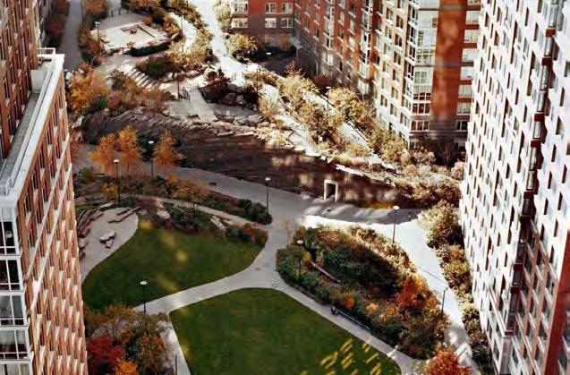
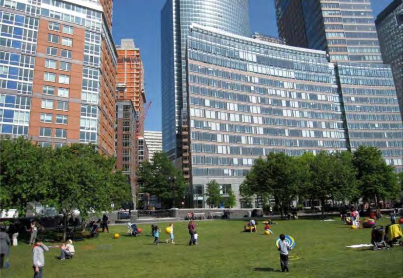
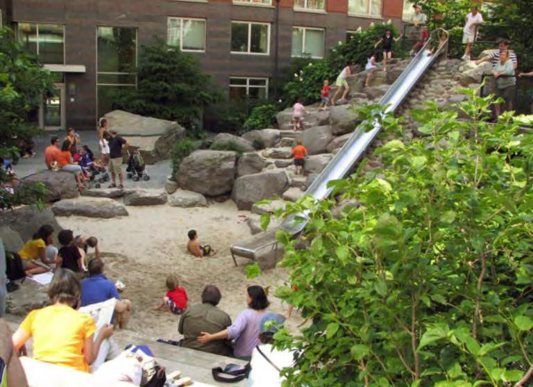
49 3C. Air rights study Study Area 49
 in study, yet Plan Framework envisions revitalized park space Reinforcing existing deck is half the cost of a new")
50 3C. Air rights study Key Assumptions MWAA-preferred height limits C-O Rosslyn parking standards Support cost of access to air rights and community benefits Included Site 3 (Gateway Park) in study, yet Plan Framework envisions revitalized park space Reinforcing existing deck is half the cost of a new deck 50


51 3C. Air rights study Potential for 2.5 million sf mixed-use development Site 1 Scenario Study 460,000sf office 220,000sf residential 10,000sf retail Waterview - Residential / Hotel Waterview - Office (Height: 242 ASE / 302 AMSL) Gateway Park Potomac Tower (Height: 237 ASE / 297 AMSL) Site 1: view from northeast 51
 for most sites Project involving site(s) 3 & 4 may be most economically feasible Currently")
52 3C. Air rights study Findings: Air rights as a long-term proposition Economic feasibility, vacancy rates, development pipeline, and complexity of project type suggests air rights as a long-term venture Sites with new deck likely at least 20 years out Rents need to increase by 13-15% (net inflation) for most sites Project involving site(s) 3 & 4 may be most economically feasible Currently 4,000,000 SF of net new development in pipeline for Rosslyn 52
53 3C. Air rights study Rosslyn Sector Plan Update Approach Staff recommends Rosslyn Sector Plan maintain current scope and only briefly address air rights development as item for future consideration, as follows: Identify broad planning goals and challenges County would like to see addressed if air rights development in this area is in fact pursued Include an implementation action item to continue to coordinate with the Commonwealth on exploring planning and development potential for the air rights sites, on an ongoing basis 53
54 3C. Air rights study LRPC Advice 54
55 3C. Air rights study Questions Does the County Board agree with generally maintaining the current scope for Realize Rosslyn, yet having the Sector Plan address the potential for air rights development in broad planning terms and aspirations, and conveying a County commitment to working with the Commonwealth on Virginia on exploring development options? 55

56 3D. Rosslyn s East End Transportation and Public Open Space 56
57 3D. Rosslyn East End Transportation and Public Open Space Street Connectivity & Esplanade Why strive for full connectivity? Street connectivity supports the public nature of the streets, site, proposed park, and esplanade Increase circulation options throughout Rosslyn Create complete streets that accommodate both vehicles and pedestrians Better integrate this edge site with its surroundings Provide opportunities for potential connectivity south (River Place) and east (air rights) 57


58 3D. Rosslyn East End Transportation and Public Open Space Street Connectivity & Esplanade 58


59 3D. Rosslyn East End Transportation and Public Open Space Street Connectivity & Esplanade 59


60 3D. Rosslyn East End Transportation and Public Open Space Street Connectivity & Esplanade Brooklyn Heights Promenade, NYC Shoemaker Green, University of Pennsylvania, Philadelphia Hoboken, NJ 60
61 3D. Rosslyn East End Transportation and Public Open Space What types of public spaces do we need? Destination Spaces Unique features, attracting visitors from the community, region and beyond (e.g. vista, monument, programmed events) Typically larger in size, can be multi-use in function Revitalizing Spaces Opportunity for respite, socializing, transition, reflection Form/amenity may vary: hardscape or soft-scape; small urban plazas, nature preserves, intimate spaces in larger parks. Seating, picnic tables, gardens, walking trails, public art Recreation Spaces Used for active recreation and leisure activities. Amenities can include playgrounds, sport facilities, dog parks, trails Depending on scale, can serve the neighborhood, the community, even the region Linking Spaces Connect other open spaces in an integrated, accessible network Often linear in form (e.g. trails, greenways, streets, linear plazas) Amenities include greenery and vegetation, seating, lighting, ecological corridors 61

62 3D. Rosslyn East End Transportation and Public Open Space Overview: Rosslyn s major parks Existing parks with new access, facilities, and other improvements Gateway Park Freedom Park Dark Star Park New park spaces adding exciting new experiences to Rosslyn The Esplanade Rosslyn Plaza Park 18 th Street Corridor 62
63 3D. Rosslyn East End Transportation and Public Open Space Rosslyn Plaza Park Type: Destination/Recreation Space Size: Acres Program Ideas: Festivals and live music Larger recreation courts (volleyball, basketball, multi-purpose courts) Small recreation courts (bocce, horseshoes, etc.) Children s play features Outdoor dining and retail Open, flexible lawn area Community canine area Outdoor table games Three general programming elements: Recreation and Activities Multiuse Green Space Retail Opportunities 63

64 3D. Rosslyn East End Transportation and Public Open Space Rosslyn Plaza Park: defining characteristics 64

65 3D. Rosslyn East End Transportation and Public Open Space Rosslyn Plaza Park: defining characteristics AREA EXCLUDING STREETS: 50,000 SF (1.2 acres) 65

66 3D. Rosslyn East End Transportation and Public Open Space Rosslyn Plaza Park: defining characteristics 66

67 3D. Rosslyn East End Transportation and Public Open Space Rosslyn Plaza Park: defining characteristics 67

68 3D. Rosslyn East End Transportation and Public Open Space Rosslyn Plaza Park: defining characteristics 68

69 3D. Rosslyn East End Transportation and Public Open Space Rosslyn Plaza Park: defining characteristics 69
 70")
70 3D. Rosslyn East End Transportation and Public Open Space Rosslyn Plaza Park: defining characteristics Jameson Square, Portland, OR (1 acre) 70

71 3D. Rosslyn East End Transportation and Public Open Space Rosslyn Plaza Park: defining characteristics 71
72 3D. Rosslyn East End Transportation and Public Open Space Rosslyn Plaza Park 1. Locate major space at intersection of 18 th and Esplanade 2. Locate major space at intersection of 18 th and Kent 72
73 3D. Rosslyn East End Transportation and Public Open Space Rosslyn Plaza Park Intersection of 18 th and Esplanade Creates open space terminus for 18 th Street Corridor at Esplanade (+) Provides potential synergies with Esplanade (+) Provides sense of openness and sky views (+) Good sunlight access in morning hours (+) Reduces conflicts between active recreation and surroundings (+) Further from Rosslyn Core (-) Limits retail potential at park edge (-) Limits some views from prime office site (-) 73
 Provides better retail potential along park edge (+) Increases some views from prime office site (+) Provides less openness to sky and connectivity to esplanade (-) Faces Kent Street")
74 3D. Rosslyn East End Transportation and Public Open Space Rosslyn Plaza Park Intersection of 18 th and Kent Celebrates frontage on 18 th Street and Kent Street/Freedom Park (+) Closer to Rosslyn Core (+) Provides better retail potential along park edge (+) Increases some views from prime office site (+) Provides less openness to sky and connectivity to esplanade (-) Faces Kent Street garage/service frontage edges (-) Potential conflicts, noise issues w/ surroundings (-) Potential constraints with direct sunlight access (-) 74
75 3D. Rosslyn East End Transportation and Public Open Space Rosslyn Plaza Park: Performance Criteria Provide a consolidated, primary open space of about 1 acre in size Accommodate a balanced mix of uses, including recreation, multiuse green space, and retail opportunities Building form and design should support the balanced mix of uses, including active recreation, and maximize sunlight opportunities on the public open space Provide visual and physical connectivity between the primary open space and 18 th Street, the Esplanade and other key routes to the space Maintain a generous view corridor down 18 th Street from Kent Street toward the esplanade If a building is located at the intersection of 18 th Street and the Esplanade, the building should be a signature building that responds to the surrounding open space and celebrates the view terminus 75
76 3D. Rosslyn East End Transportation and Public Open Space LRPC Advice Connectivity: Create new 17 th and 18 th Streets that connect Arlington Ridge Road on the plaza level to Kent Street. Connect Arlington Ridge Road on the plaza level via ramps to Wilson Boulevard on the south and 19 th Street on the north. Create an esplanade that parallels Arlington Ridge Road that could be extended to Gateway Park on the north and the Iwo Jima Memorial on the south. Open Space: Support staff s guidance on the location (Arlington Ridge Road frontage), size, and program opportunities for the Rosslyn Plaza open space. Affirm the staff proposal that the open space be comprised of multiple areas that can be combined to form an area of about two acres for both active and passive recreation. 76
77 3D. Rosslyn East End Transportation and Public Open Space Does the County Board agree with the proposed full connectivity among Arlington Ridge Road, 17 th and 18 th Streets, with an Esplanade paralleling Arlington Ridge Road? Is the proposed guidance for the size and program opportunities, particularly the focus on active recreation and multiuse green space, of the public open space envisioned in Rosslyn s East End generally moving in the right direction? Should the sector plan allow flexibility for the public open space envisioned in Rosslyn s East End to be located on Kent Street rather than on the Esplanade, provided it meets the proposed performance criteria? 77

78 5. Updated schedule and next steps 78
79 5. Updated Schedule Month Meetings Milestones February Rosslyn Process Panel (2/2) LRPC (2/18) March County Board Work Session (3/4) April Rosslyn Process Panel (TBD) Civic Associations (TBD,) Advisory Commissions (TBD) LRPC (TBD) Community Open House (TBD) May Planning Commission (RTA) County Board (RTA) June Planning Commission County Board (Action) 1 st Draft Plan for Public Review RTA Draft Plan issued Rosslyn Sector Plan Update Adoption 79
80 ADJOURNMENT 80
Adoption of the Rosslyn Sector Plan Site Plan Review Committee (SPRC) Meeting October 26, 2015
 Meeting October 26, 2015") Adoption of the Rosslyn Sector Plan Site Plan Review Committee (SPRC) Meeting October 26, 2015 Rosslyn Sector Plan Introduction Adopted by the County Board in July 2015 Reflects the new long range planning
Adoption of the Rosslyn Sector Plan Site Plan Review Committee (SPRC) Meeting October 26, 2015 Rosslyn Sector Plan Introduction Adopted by the County Board in July 2015 Reflects the new long range planning
GOODY CLANCY WITH KITTELSON & ASSOCIATES RHODESIDE & HARWELL FARR ASSOCIATES W-ZHA
 1 1. Welcome 5 min. 2. Follow-up from 9/22 / Corridor of Light, ground floor uses 20 min. 3. Small on-site open spaces / Overview of types, identities 15 min. 4. Rosslyn Plaza Park / Rosslyn Plaza PDSP
ARLINGTON COUNTY, VIRGINIA
 ARLINGTON COUNTY, VIRGINIA County Board Agenda Item Meeting of March 20, 2007 SUPPLEMENTAL REPORT #2 Additional and Revised Information DATE: March 20, 2007 SUBJECT: Request to Advertise Public Hearings
Rosslyn Sector Plan Implementation
 DEPARTMENT OF COMMUNITY PLANNING, HOUSING AND DEVELOPMENT Planning Division #1 Courthouse Plaza, 2100 Clarendon Boulevard, Suite 700 Arlington, VA 22201 TEL 703.228.3525 FAX 703.228.3543 www.arlingtonva.us
Rosslyn Plaza PDSP (SP #422) SPRC Staff Presentation
 SPRC Staff Presentation") Rosslyn Plaza PDSP (SP #422) SPRC Staff Presentation ote Guiding Principles included in this document are taken from the latest working draft of the Guiding Principles dated. The illustrations included
Rosslyn Plaza PDSP (SP #422) SPRC Staff Presentation ote Guiding Principles included in this document are taken from the latest working draft of the Guiding Principles dated. The illustrations included
GOODY CLANCY WITH KITTELSON & ASSOCIATES RHODESIDE & HARWELL FARR ASSOCIATES W-ZHA
 1 1. Welcome / Subcommittee introductions, role, goals, Realize Rosslyn process overview 10 min. 2. Existing parks/open space context 10 min. 3. The Rosslyn Plan framework / Parks & open space overview
Realizing Rosslyn: a new era of opportunity GOODY CLANCY WITH KITTELSON & ASSOCIATES RHODESIDE & HARWELL FARR ASSOCIATES W-ZHA
 Realizing Rosslyn: a new era of opportunity PRESENTATION OUTLINE 2 3 4 Building tops tour: what we observed 5 Building height/form and urban design: interrelated elements 6 WORK SEQUENCE 7 Building height/form
W i l s o n B o u l e v a r d & K e y B o u l e v a r d
 1 4 0 1 W i l s o n B o u l e v a r d & 1 4 0 0 K e y B o u l e v a r d R o s s l y n, A r l i n g t o n C o u n t y, V i r g i n i a S i t e P l a n R e v i e w C o m m i t t e e M e e t i n g # 8 0 4.
CRYSTAL CITY BLOCK PLAN # CCBP- G 1 DRAFT
 CRYSTAL CITY BLOCK PLAN # CCBP- G 1 DRAFT BLOCK G (Metro Market Square block) Long Range Planning Committee Meeting January 29, 2018 1 1. Introduction 2 1. LRPC Meeting Purpose Review of proposed Crystal
Appendix I ARLINGTON COUNTY SECTOR PLANS SUMMARY RECOMMENDATIONS RELATED TO PUBLIC SPACES
 Appendix I ARLINGTON COUNTY SECTOR PLANS SUMMARY RECOMMENDATIONS RELATED TO PUBLIC SPACES The County has developed Sector Plans for various planning areas within Arlington County s Metro corridors. Following
ARLINGTON COUNTY, VIRGINIA
 ARLINGTON COUNTY, VIRGINIA County Board Agenda Item Meeting October 15, 2005 DATE: September 28, 2005 SUBJECT: Request to Advertise the adoption of the 2005 Clarendon Sector Plan C. M. RECOMMENDATION:
TO: FROM: SUBJECT: Background
 TO: FROM: SUBJECT: Long Range Planning Committee and Zoning Committee of the Planning Commission Kellie Brown and Margaret Rhodes, Planning Division, CPHD DATE: June 8, 2017 Courthouse Square Implementation
Public Workshop. November 8, 2014 Key Elementary School
 Public Workshop November 8, 2014 Key Elementary School Agenda: I. Opening Remarks II. Overview of Study III. Review of Concept Plans IV. Q&A V. Break VI. Table Exercises VII. Wrap Up VIII. Adjournment
July 23, 2014 Wilson School. Working Group Meeting #3 Preliminary Site Analysis School Siting Considerations Guiding Principles
 July 23, 2014 Wilson School Working Group Meeting #3 Preliminary Site Analysis School Siting Considerations Guiding Principles Agenda Follow-Up from Meeting #2: WG & community feedback Presentations /
Courthouse Square Planning & Urban Design Study. Courthouse Square Working Group #13 October 15, 2014
 Courthouse Square Planning & Urban Design Study Courthouse Square Working Group #13 October 15, 2014 1 Courthouse Square Process Working Group Community Courthouse Square Advisory Groups & Civic Associations
Open Space Considerations
 Open Space Considerations Department of Parks & Recreation WESTERN ROSSLYN AREA PLANNING STUDY WORKING GROUP MEETING OCTOBER 9, 2014 1 Purpose of the Presentation Provide context of the Rosslyn park and
Gold Line Bus Rapid Transit Transit Oriented Development (BRTOD) Helmo Station Area Plan
 Helmo Station Area Plan") Appendix F Gold Line Bus Rapid Transit Transit Oriented Development (BRTOD) Helmo Station Area Plan Introduction and Purpose of the Plan The Gold Line Bus Rapid Transit facility is an eleven-mile dedicated
Appendix F Gold Line Bus Rapid Transit Transit Oriented Development (BRTOD) Helmo Station Area Plan Introduction and Purpose of the Plan The Gold Line Bus Rapid Transit facility is an eleven-mile dedicated
CRYSTAL CITY BLOCK PLAN # CCBP- G 1
 CRYSTAL CITY BLOCK PLAN # CCBP- G 1 BLOCK G (Metro Market Square block) Long Range Planning Committee Meeting #3 April 2, 2018 1 1. Tonight s Agenda 1. Introductory Remarks (Jane Siegel) 2. Follow-up from
DRAFT PLAN PRESENTATION
 DRAFT PLAN PRESENTATION 1.23.2018 AGENDA Process Project Schedule Results from Visioning Workshop Draft Plan Highlights Concept Plans Feedback Next Steps PROJECT SCHEDULE KICK-OFF WORKSHOP August 29 th
ARLINGTON COUNTY, VIRGINIA. County Board Agenda Item Meeting of March 15, 2014
 ARLINGTON COUNTY, VIRGINIA County Board Agenda Item Meeting of March 15, 2014 DATE: March 12, 2014 SUBJECT: Request to Advertise Public Hearings to consider the adoption of the Rosslyn Plan Framework (Attachment
Seneca Meadows. Block 4 Locate office, technology, and medical development adjacent to I Screen views of garage structures from I-270.
 Seneca Meadows Seneca Meadows has an industrial park in its southern end and a mixed-use employment area planned for the north end. The district benefits from extensive I-270 visibility, stream valley
POPS Advisory Committee Meeting May 31, 2018
 POPS Advisory Committee Meeting May 31, 2018 NOTE: This presentation is a working document, and some recommendations or ideas may have evolved or changed based on continued discussions and additional analyses.
Workshop 3. City of Burlington Waterfront Hotel Planning Study. September 14, The Planning Partnership
 Workshop 3 City of Burlington Waterfront Hotel Planning Study September 14, 2017 The Planning Partnership The Waterfront Hotel Planning Study 01 The Brant & Lakeshore Planning Study will establish a Strategic
ROSSLYN GATEWAY URBAN DESIGN MANUAL JULY 15, 2011 REVISED JANUARY 30, KOHN PEDERSEN FOX ASSOCIATES PC. All rights reserved.
 ROSSLYN GATEWAY URBAN DESIGN MANUAL JULY 15, 2011 REVISED JANUARY 30, 2012 OVERVIEW Rosslyn Gateway is mixed-use development located at the Virginia landing of the Francis Scott Key Bridge in Rosslyn,
VICTORIA DOWNTOWN DEVELOPMENT PLANNING
 VICTORIA DOWNTOWN DEVELOPMENT PLANNING A Vision & Guide for the Future Downtown Victoria thrives as a center for the community, offering a great mix of entertainment, culture, business, and recreational
City of Farmington. Downtown Plan. Amendment to the 1998 Master Plan Adopted October 11, 2004
 City of Farmington Amendment to the 1998 Master Plan Adopted October 11, 2004 Introduction Planning Background 1 Scope and Components of the Plan Amendment 2 Concept Introduction 3 Plan Concepts 3 Conceptual
18 May 2016 CAMPUS MASTER PLAN UPATE
 18 May 2016 CAMPUS MASTER PLAN UPATE Council of the Deans ( Over view) AGENDA Engagement & What We Heard Focus Elements: 1. Development Framework Plan 2. Campus Mobility 3. Campus Guidelines 4. Wayfinding
Arlington, Virginia is a worldclass
 EXECUTIVE S U M M A RY Arlington maintains a rich variety of stable neighborhoods, quality schools and enlightened land use policies, and received the Environmental Protection Agency s highest award for
Project Introduction Visioning. Next Steps. Slide 1
 Project Introduction Visioning QA Next Steps Slide 1 Good Gateway to Arlington Great Neighborhood Park for Rosslyn Slide 2 Existing Conditions Program Conceptual Strategies Slide 3 Existing Conditions
PLAN ELEMENTS WORKSHOP. April 5, 2016
 PLAN ELEMENTS WORKSHOP April 5, 2016 needs more housing. But there is no one-size fits-all solution. Every neighborhood has its own character. In some places, density is not only appropriate it is badly
Phase I Redevelopment Plan. First Community Meeting
 Hoboken Terminal and Yard Phase I Redevelopment Plan First Community Meeting May 31, 2011 One Hudson Place Phase I Redevelopment Plan Redevelopment Plan First Community Meeting Agenda 1. Redevelopment
Throughout. square. (Crystal City Vision Plan 2050)
") 1: Terms related to the PSMP document 1 public space (see also public realm, civic space) An open space designated on the regulating plan, accessible to all, including Plazas, Mini Parks, and Neighborhoods
1: Terms related to the PSMP document 1 public space (see also public realm, civic space) An open space designated on the regulating plan, accessible to all, including Plazas, Mini Parks, and Neighborhoods
The University District envisions, in its neighborhood
 Envisioning the University District Link Light Rail in Seattle s neighborhoods CIY OF SEALE CONCEP-LEVEL SAION AREA PLANNING RECOMMENDAION RESOLUION # 30165 EXHIBI L Vision 08.2000 he University District
ATTACHMENT. To the west, north, and east of the block, primarily singlefamily detached residential patterns, with some townhouses, predominate.
 COMMENT / REVISION MATRIX (as of ) for Washington and Kirkwood Special GLUP Study "Plus" and Concept Plan 1 2 Resolve inconsistency between American Legion site area noted in Map 1 1.36 AC 1.29 AC and
Midtown Greenway Land Use and Development Plan Executive Summary
 Midtown Greenway Land Use and Development Plan Executive Summary Introduction The Midtown Greenway Land Use and Development Plan sets policy direction for land use and development in the Midtown Greenway
SITE PLAN AREA. Met Park 6 Site Area (122,368 sf) Met Park 4/5 The Bartlett. Met Park 3 The Acadia. Met Park 2 The Millennium.
 Met Park 4/5 The Bartlett. Met Park 3 The Acadia. Met Park 2 The Millennium.") SITE PLAN AREA Met Park 4/5 The Bartlett Met Park 3 The Acadia Met Park 2 The Millennium Met Park 6 Site Area (122,368 sf) Met Park 1 The Gramercy Met Park 7 and 8 2 SUBJECT SITE Existing Use: Pentagon
SITE PLAN AREA Met Park 4/5 The Bartlett Met Park 3 The Acadia Met Park 2 The Millennium Met Park 6 Site Area (122,368 sf) Met Park 1 The Gramercy Met Park 7 and 8 2 SUBJECT SITE Existing Use: Pentagon
Corridor Vision. 1Pursue Minnehaha-Hiawatha Community Works Project. Mission of Hennepin County Community Works Program
 1Pursue Minnehaha-Hiawatha Community Works Project Minnehaha-Hiawatha Community Works is a project within the Hennepin Community Works (HCW) program. The mission of the HCW program is to enhance how the
ELMVALE ACRES SHOPPING CENTRE MASTER PLAN
 ELMVALE ACRES SHOPPING CENTRE MASTER PLAN Contents 1.0 INTRODUCTION... 2 2.0 LOCATION... 2 3.0 EXISTING CONTEXT... 2 4.0 VISION & GUIDING PRINCIPLES... 2 5.0 LAND USE AND BUILT FORM... 4 5.1 St. Laurent
Status Report: MD 355 Project
 Status Report: MD 355 Project OCTOBER 2006 M-NCPPC MONTGOMERY COUNTY PLANNING DEPARTMENT Summary of Community Comments, and break to the Results of the MD 355 Participation Session Brookside Gardens -
LAND USE AMENDMENT DOWNTOWN COMMERCIAL CORE (WARD 7) MACLEOD TRAIL SE AND 5 AVENUE SE BYLAW 254D2017
 MACLEOD TRAIL SE AND 5 AVENUE SE BYLAW 254D2017") Page 1 of 10 EXECUTIVE SUMMARY This Land Use Amendment application seeks to redesignate a full downtown block (currently the YWCA site) from a Direct Control based on the CM-2 District (Land Use Bylaw
Page 1 of 10 EXECUTIVE SUMMARY This Land Use Amendment application seeks to redesignate a full downtown block (currently the YWCA site) from a Direct Control based on the CM-2 District (Land Use Bylaw
Courthouse Square Implementation Comment/Response Matrix
 Courthouse Square Implementation /Response Matrix 1 Are open space symbols binding? GLUP No, open space symbols are not binding, as the GLUP is a policy instrument illustrating the County s future vision
This Review Is Divided Into Two Phases:
 Semiahmoo Town Centre Review The purpose of this review: To review the Semiahmoo Town Centre Concept Plan, originally approved in 1993, to ensure that this centre will continue to serve the needs of South
IMAGINE CLEARWATER. Community Workshop 3. November 2016
 IMAGINE CLEARWATER Community Workshop 3 November 2016 Imagine Clearwater has been a 6-month community-focused process to re-envision the downtown waterfront. VISIONING FRAMEWORK MASTER PLAN HOW CAN WE
Bloor Street East Potential Ravine Portal Overlook and Access Passage to the Rosedale Valley and Don River Valley Ravine, Toronto, Canada
 TRANSFORMATIVE IDEA 2. GREAT STREETS Bloor Street Christie Pits Park Bloor St Spadina Ave Bathurst St Shaw St 1 Recognize the significant public realm improvements along Bloor Street and extend and enhance
St. Kevin s Area Planning Collaborative
 Table of Contents page 2 EXECUTIVE SUMMARY 3 MISSION STATEMENT 4 NEIGHBORHOOD CONTEXT 6 STREET CHARACTER 7 SITE PARAMETERS 9 COMMUNITY CHARRETTE - VISIONING GROUP TABLE 1 11 GROUP TABLE 2 12 GROUP TABLE
SP #94, AREP Rosslyn City Center
 SP #94, AREP Rosslyn City Center 1700 & 1810 N. Moore Street Department of Community Planning, Housing, and Development County Board July 15, 2017 1 19 th Street N. Wilson Boulevard Location Rosslyn City
CHAPTER 7: VISION AND ACTION STATEMENTS. Noble 2025 Vision Statement
 CHAPTER 7: VISION AND ACTION STATEMENTS This chapter presents the vision, policy and action statements that transform the comprehensive planning study, an analysis of Noble s past, future trends and community
North Downtown Specific Plan MEMORANDUM
 North Downtown Specific Plan MEMORANDUM MEETING DATE: November 13, 2017 TO: Members of the North Downtown Specific Plan Advisory Committee FROM: Jeanine Cavalli, Senior Planner SUBJECT: Materials for the
Status Update (2006 vs. Now) Citizen s Advisory Committee February Plan for Prosperity
 Citizen s Advisory Committee February Plan for Prosperity") Status Update (2006 vs. Now) Citizen s Advisory Committee February 2018 Plan for Prosperity 2000 2017 2000 2017 Gardnerville Population 6,000 5,760 5746 5,500 5,000 5,067 5,550 5,165 5,394 5,412 5,250
Status Update (2006 vs. Now) Citizen s Advisory Committee February 2018 Plan for Prosperity 2000 2017 2000 2017 Gardnerville Population 6,000 5,760 5746 5,500 5,000 5,067 5,550 5,165 5,394 5,412 5,250
FOUR MILE RUN VALLEY WORKING GROUP AND CHARGE
 FOUR MILE RUN VALLEY WORKING GROUP AND CHARGE Adopted April 16, 2016 Amended July 19, 2016 Overview of Integrated Effort The overall goal of the Four Mile Run Valley (4MRV) initiative is to develop a comprehensive
Policies and Code Intent Sections Related to Town Center
 Policies and Code Intent Sections Related to Town Center The Town Center Vision is scattered throughout the Comprehensive Plan, development code and the 1994 Town Center Plan. What follows are sections
Town Center (part of the Comprehensive Plan)
") Town Center (part of the Comprehensive Plan) Mercer Island Town Center Looking North (2014) In 1994, a year-long process culminated in a set of design guidelines and code requirements for the Town Center
Town Center (part of the Comprehensive Plan) Mercer Island Town Center Looking North (2014) In 1994, a year-long process culminated in a set of design guidelines and code requirements for the Town Center
Public may provide comments on the GDP within the next two weeks (December 24)
") 25/70 General Development Plan (GDP) Public Meeting Wednesday, December 10, 2014 6:00 8:00 P.M. District 1 Police Station Community Room 1311 W 46th Ave, Denver, CO 80211 Council Woman Montero: This particular
25/70 General Development Plan (GDP) Public Meeting Wednesday, December 10, 2014 6:00 8:00 P.M. District 1 Police Station Community Room 1311 W 46th Ave, Denver, CO 80211 Council Woman Montero: This particular
chapter DESIGN GUIDELINES NEW RIVER MASTER PLAN REPORT
 chapter DESIGN GUIDELINES NEW RIVER MASTER PLAN REPORT .76 DESIGN GUIDELINES An Overview design guidelines NEW RIVER MASTER PLAN Design Guidelines can transform the image of a city. Specific, design-based
WRAPS Guiding Principles Working Group Survey Responses September 2014
 WRAPS Guiding Principles Working Group Survey Responses September 2014 # Question Q.1 Uses / Use Mix / Density / Affordable Housing Ideas 1 Develop with densities that reflect study area as extension of
ARLINGTON COUNTY, VIRGINIA. County Board Agenda Item Meeting of March 15, 2014
 ARLINGTON COUNTY, VIRGINIA County Board Agenda Item Meeting of March 15, 2014 DATE: March 12, 2014 SUBJECT: Request to Advertise Public Hearings to consider the adoption of the Rosslyn Plan Framework (Attachment
DENVER DESIGN DISTRICT GDP
 DENVER DESIGN DISTRICT GDP Urban Design Standards and Guidelines November 17, 2008 Amended February 3, 2016 City and County of Denver CF Property Management, Inc. C/O Denver Design District - Starboard
Strategic Growth Area #1 Northampton Boulevard Corridor Area
 Strategic Growth Area #1 Northampton Boulevard Corridor Area Description Strategic Growth Area #1 has established itself as a major employment center in Southside Hampton Roads. Opportunities exist to
Description of Preferred Alternative
 Chapter 2 Description of Preferred Alternative 2.1 Introduction This chapter of the programmatic Sammamish Town Center Sub-area Plan Final EIS provides a more detailed description of the Preferred Alternative
Scope of Services. River Oaks Boulevard (SH 183) Corridor Master Plan
 Corridor Master Plan") Scope of Services River Oaks Boulevard (SH 183) Corridor Master Plan PROJECT AREA The project area consists of the River Oaks Boulevard (SH 183) corridor bounded by SH 199 at the northern end and the Trinity
Scope of Services River Oaks Boulevard (SH 183) Corridor Master Plan PROJECT AREA The project area consists of the River Oaks Boulevard (SH 183) corridor bounded by SH 199 at the northern end and the Trinity
DRAFT. October Wheaton. Design Guidelines
 October 2011 DRAFT Wheaton Design Guidelines 2 Draft - Design Guidelines - Wheaton Sector Plan Contents 04 Section 1: Introduction 06 Section 2: Context 08 Section 3: Design Guidelines 09 Goal 1: Create
Clairtrell Area Context Plan
 Clairtrell Area Context Plan March 2005 Urban Development Services City Planning Contents 1. Introduction... 4 2. Development Structure... 6 2.1 Streets... 7 2.1.1 Sheppard Avenue and Bayview Avenue...
ROSSLYN PLAN FRAMEWORK
 ROSSLYN PLAN FRAMEWORK VISION PRINCIPLES AND POLICY DIRECTIVES TO GUIDE THE ROSSLYN SECTOR PLAN UPDATE DRAFT 2014.02.19 MARCH 2014 IMAGE COURTESY OF JBG COMPANIES. DRAFT 2014.02.19 ROSSLYN PLAN FRAMEWORK
Design Alternatives Workshop. Hilfiker Park Master Plan Workshop #2
 Design Alternatives Workshop Hilfiker Park Master Plan Workshop #2 Agenda for Tonight Staff Presentation (40 min) Introduction Master Plan Process Planning Context What We ve Heard So Far Design Alternatives
M i s s i o n B a y W a t e r f r o n t
 114 M i s s i o n B a y W a t e r f r o n t Character of the Area: The Mission Bay Waterfront extends from Pier 48 at China Basin Channel to 18th Street in the Central Basin. This area of the waterfront
ARLINGTON COUNTY, VIRGINIA. County Board Agenda Item Meeting of June 13, 2015
 ARLINGTON COUNTY, VIRGINIA County Board Agenda Item Meeting of June 13, 2015 DATE: June 10, 2015 SUBJECT: Request to Authorize Advertisement of Public Hearings by the Planning Commission and the County
3. VISION AND GOALS. Vision Statement. Goals, Objectives and Policies
 Vision Statement Queen Creek s interconnected network of parks, trails, open spaces and recreation opportunities provide safe and diverse activities and programs that sustain its unique, small town, equestrian
Colchester Northern Gateway Master Plan Vision Review Draft. July 2016
 Colchester Northern Gateway Master Plan Vision Review Draft July 2016 Contents Introduction 4 Context 8 Purpose of the Report 8 Strategic Position 9 Overview of the Process 11 2012 Master Plan Vision 12
Silver Line CPAM UPDATE. Transportation and Land Use Committee October 14, 2016
 Silver Line CPAM UPDATE Transportation and Land Use Committee October 14, 2016 Purpose Recap Project History and Map Changes Provide Overview of CPAM Components Discuss Transportation Impacts Discuss Fiscal
PINE CURVE REZONING. BACKGROUND Purchased as two parcels in 2001 and 2002
 BACKGROUND Purchased as two parcels in 2001 and 2002 WHAT THE PROJECT IS AND IS NOT A Rezoning establishes the land use standards for Annexed and Zoned Greater Downtown District Historic Center September
Urban Planning and Land Use
 Urban Planning and Land Use 701 North 7 th Street, Room 423 Phone: (913) 573-5750 Kansas City, Kansas 66101 Fax: (913) 573-5796 Email: planninginfo@wycokck.org www.wycokck.org/planning To: From: City Planning
ARLINGTON COUNTY, VIRGINIA. County Board Agenda Item Meeting of April 21, 2018 SUPPLEMENTAL REPORT
 ARLINGTON COUNTY, VIRGINIA County Board Agenda Item Meeting of April 21, 2018 SUPPLEMENTAL REPORT DATE: April 18, 2018 SUBJECT: Request to authorize advertisement of public hearings by the Planning Commission
Additional information about land use types is given in Chapter 5. Design guidelines for Centers and Neighborhoods are given in Chapter 7.
 4. Place Types Introduction In Albemarle County s Development Areas, the Neighborhood is the fundamental unit of community planning. The County s Neighborhood Model, an adopted part of the Comprehensive
Ivywild On The Creek PRELIMINARY CREEK DISTRICT MASTER PLAN
 Ivywild On The Creek PRELIMINARY CREEK DISTRICT MASTER PLAN Introduction: Rejuvenating an extraordinary Creekside neighborhood THE CREEKSIDE DISTRICT The Ivywild On The Creek Neighborhood District Master
Town Center. Block 5 Existing multifamily residential units are expected to remain.
 Area Guidelines Germantown s districts should be developed as distinct communities with unique features that are supported through the guidelines. The guidelines not only help distinguish these districts
Courthouse Square Planning & Urban Design Study
 Courthouse Square Planning & Urban Design Study Pedestrian Advisory Committee November 12, 2014 Kris Krider, AICP, Planning Supervisor Center for Urban Design and Research Department of Community Planning,
MAYFIELD WEST SECONDARY PLAN PHASE 2
 MAYFIELD WEST SECONDARY PLAN PHASE 2 Public Open House #3 February 25, 2010 Draft Preferred Land Use Scenario TOWN OF CALEDON PLANNING & DEVELOPMENT DEPARTMENT Open House Agenda TOWN OF CALEDON 1. Welcome
Urban Design Manual PLANNING AROUND RAPID TRANSIT STATIONS (PARTS) Introduction. Station Study Areas
 Introduction. Station Study Areas") 111111 PLANNING AROUND RAPID TRANSIT STATIONS (PARTS) Introduction The ION rapid transit system will link Waterloo, Kitchener and Cambridge through a central transit corridor (CTC). There are a number
111111 PLANNING AROUND RAPID TRANSIT STATIONS (PARTS) Introduction The ION rapid transit system will link Waterloo, Kitchener and Cambridge through a central transit corridor (CTC). There are a number
Arlington County. Envision Courthouse Square Planning and Urban Design Study 21 May 2014
 Arlington County Envision Courthouse Square Planning and Urban Design Study 21 May 2014 Cooper, Robertson & Partners Architecture, Urban Design with Buro Happold, HR&A, Kimley Horn, Nelson Nygaard, & Tactical
PUBLIC SPACES MASTER PLAN UPDATE (POPS) Joint Facilities Advisory Commission (JFAC) November 28, 2018
 Joint Facilities Advisory Commission (JFAC) November 28, 2018") PUBLIC SPACES MASTER PLAN UPDATE (POPS) Joint Facilities Advisory Commission (JFAC) November 28, 2018 1 AGENDA POPS Planning Context Timeline Public Input Final POPS Draft Next Steps 2 PLANNING CONTEXT
PUBLIC SPACES MASTER PLAN UPDATE (POPS) Joint Facilities Advisory Commission (JFAC) November 28, 2018 1 AGENDA POPS Planning Context Timeline Public Input Final POPS Draft Next Steps 2 PLANNING CONTEXT
Pedestrian and Bike Bridge LOGO
 6.2.2 Pedestrian and Bike Bridge The proposed pedestrian and bike crossing re-envisions the existing bridge at Pismo Creek on Cypress Street. The bridge is currently underutilized by vehicular through
Preliminary Recommendations Tk Takoma/Langley Crossroads Sector Plan
 Preliminary Recommendations Tk Takoma/Langley Crossroads Sector Plan Vision is to achieve a Transit Oriented, pedestrian friendly Community that Celebrates and builds upon the cultural Diversity of the
Urban Design Brief. Watson Parkway North & Watson Road North Guelph, Ontario. Prepared by Coletara Development
 Urban Design Brief Watson Parkway North & Watson Road North Guelph, Ontario Prepared by Coletara Development December, 2013 Urban Design Brief, Coletara Development 1 Introduction This Urban Design Brief
ARLINGTON COUNTY, VIRGINIA
 ARLINGTON COUNTY, VIRGINIA County Board Agenda Item Meeting of July 21, 2012 DATE: July 12, 2012 SUBJECT: SP #416 SITE PLAN AMENDMENT to modify condition #6 to eliminate requirement to provide a pedestrian
THE NEIGHBORHOOD TODAY
 THE NEIGHBORHOOD TODAY CORE AREA VISION How are we Good Urbanism A Site s DNA thinking about Elements of great Unique elements urban communities embedded in a place the site and design? ELEMENTS LIKE:
public review draft Key objectives for this chapter are:
 5 - parks & open space Providing a rich collection of outdoor places for informal gathering and recreation, as well as planned promotional activities and community events, is a key concept for Midtown.
Rosslyn Highlands Park + Coordinated Open Spaces Plan (Plan Adoption) County Board Meeting September 24, 2016
 County Board Meeting September 24, 2016") Rosslyn Highlands Park + Coordinated Open Spaces Plan (Plan Adoption) County Board Meeting September 24, 2016 BACKGROUND The County Board shall consider adoption of the proposed Rosslyn Highlands Park
Rosslyn Highlands Park + Coordinated Open Spaces Plan (Plan Adoption) County Board Meeting September 24, 2016 BACKGROUND The County Board shall consider adoption of the proposed Rosslyn Highlands Park
Westwood Shopping Center Sketch Plan, Plan # February 23, 2017 Item # 9
 Westwood Shopping Center Sketch Plan, Plan # 320170010 February 23, 2017 Item # 9 Westwood II Site 64,111 s.f. Manor Care site: vacant two story building HOC-Westwood Towers, 15 story tower To be considered
WEST LOOP DESIGN GUIDELINES CHECKLIST
 WEST LOOP DESIGN GUIDELINES CHECKLIST Section 1.0 General Strategies 1.1 DESIGN EXCELLENCE: ENCOURAGE HIGH QUALITY AND INNOVATIVE DESIGN OF NEW BUILDINGS WITHIN THE WEST LOOP WITHOUT BEING PRESCRIPTIVE
Wheaton CBD & Vicinity Sector Plan D E S I G N G U I D E L I N E S
 Wheaton CBD & Vicinity Sector Plan D E S I G N G U I D E L I N E S 1 a b s t r a c t This document contains the design guidelines the property owners, community members, and planners should use to implement
Courthouse Square Planning & Urban Design Study. Clarendon / Courthouse Civic Association October 21, 2014
 Courthouse Square Planning & Urban Design Study Clarendon / Courthouse Civic Association October 21, 2014 1 Courthouse Square Process Working Group Community Courthouse Square Advisory Groups & Civic Associations
North Fair Oaks Community Plan Summary and Information
 North Fair Oaks Community Plan Summary and Information WHAT IS THE NORTH FAIR OAKS COMMUNITY PLAN? The North Fair Oaks Community Plan is part of the San Mateo County General Plan, and establishes policies
Page 1 of 19 URBAN DESIGN FRAMEWORK FOR BOLTON STREET WATERFORD
 Page 1 of 19 URBAN DESIGN FRAMEWORK FOR BOLTON STREET WATERFORD 1.0 Introduction: The relocation of the City Council stores and depot from Bolton Street creates an exciting opportunity for development
SECTION TWO: Urban Design Concepts
 SECTION TWO: Urban Design Concepts The Gardnerville Plan for Prosperity shapes economic opportunities presented by regional growth. The Urban Design Concepts provide policies and concepts for land use,
WRAPS Site Studies. Cooper, Robertson & Partners. December 8, Page 1
 WRAPS Page 1 Realigned N. Pierce Street & Extension Base 1 FOR PRESENTATION TOTAL GSF OFFICE 346,000 RESIDENTIAL 795,000 POTENTIAL RETAIL 40,000 TOTAL 1,181,000 795 DU Open Space (Development Parcels)
1401 Wilson Boulevard SP #429
 1401 Wilson Boulevard SP #429 SPRC #2 Aaron Shriber, DCPHD Anthony Fusarelli, DCPHD September 19, 2013 ~ ARLINGTON VIRG I NIA Site Location 2 ~ L I NGTON A R VIRG I NIA GLUP Designation 3 ARLI N GTON VIJlG
Sub Area 2: Downtown Overland Park
 Downtown 132 2.12 encompasses over 600 acres and extends between 71st Street and 87 th Street including Downtown Overland Park. The area is home to several individual historic sites and structures, including
University of Saskatchewan CAMPUS MASTER PLAN. Senate Meeting Preliminary Presentation. April 21, 2018 DIALOG ECS DA WATT
 University of Saskatchewan CAMPUS MASTER PLAN Senate Meeting Preliminary Presentation April 21, 2018 DIALOG ECS DA WATT project process presentation agenda Stakeholder Engagement Project Control phase1
Draft Memorandum #1: Goals and Vision for Revitalization
 Keizer Revitalization Plan Draft Memorandum #1: Goals and Vision for Revitalization Submitted to: City of Keizer April 12, 2018 (revised) Prepared By: Angelo Planning Group and Otak, Inc. Project No. 17482.A
Chapter 1.0 Introduction
 Chapter 1.0 Introduction 1.1 Background The North Metro commuter rail line is part of the RTD FasTracks regional transit system expansion program to build more than 100 miles of rail transit throughout