South Fulton Parkway Transit Feasibility Study
|
|
|
- Christina Little
- 5 years ago
- Views:
Transcription


1 South Fulton Parkway Transit Feasibility Study
2 Study Purpose To conduct a high level assessment of potential transit improvements in the South Fulton Parkway Corridor through the evaluation of various transit service and land use scenarios Study Approach Assessment of Existing and Projected Conditions Development of Land Use Scenarios Projection of Transit Demand Identification of Needed Actions 2
3 3

4 Summary of Corridor Characteristics Study area currently characterized by low density development patterns and zoning Local jurisdictions have expressed desire to promote nodal development 90 percent of commuter trips destined for employment centers outside of the study area South Fulton Parkway designed to be a limited access facility Travel demand modeling results confirmed: Land use initiatives to promote smart growth needed within corridor to support transit Need for circulator routes to support premium services Phased approach needed due to uncertainty of time needed for development to occur 4

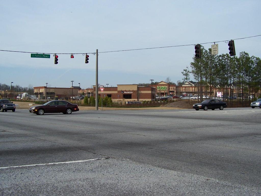
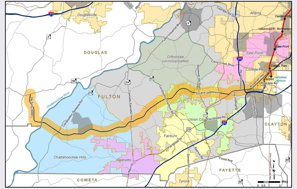
5 Snapshot of Major Intersections SR 92 5

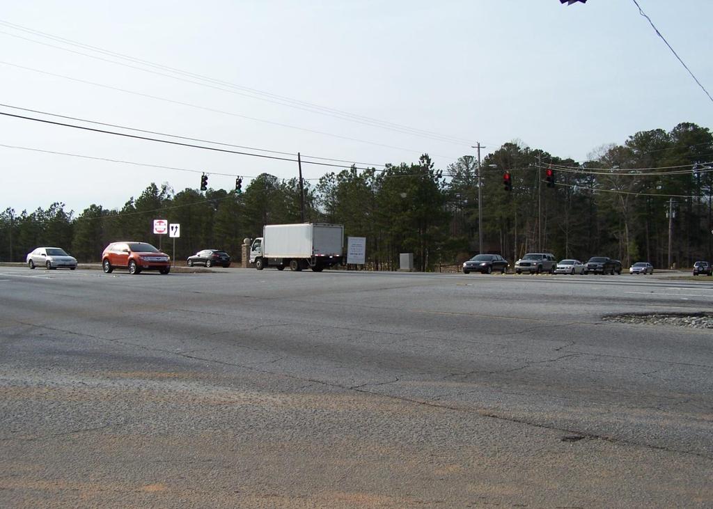
6 Snapshot of Major Intersections Stonewall Tell 6
7 Factors Influencing Recommendations The type of transit service along the South Fulton Parkway is contingent upon: Type of development that local jurisdictions along the corridor are willing to implement Cooperation/coordination with GDOT to accommodate the phased expansion of transit service 7

8 Potential Transit for South Fulton Administer Preference survey Identify locations for TOD Potential Immediate Enhancements Coordinate with GDOT & ARC for widening of Roosevelt Highway Enhance pedestrian access along Roosevelt Highway Upgrade local bus service along Old National Highway 8
9 Phase I - Schematic Station Concept for Commuter Bus Commuter travel demand sufficient per preference survey, Park-and-ride facilities built Operational improvements to South Fulton Parkway and connecting roadways to provide better access to park and ride facilities TOD plans developed by local jurisdictions Surrounding single-family development increases 9

10 Phase II - Schematic Station Concept for Enhanced Bus TOD Implementation begins at station area Parking facilities expanded Commuter travel demand increases Surrounding single-family development increases Development of Parkway South begins Old National LCI initiatives begin 10


11 Phase III - Schematic Station Concept for Fixed Guideway Services TOD Implementation maximized at station area Park-and-ride structure expanded Surrounding single-family development built-out Development of Parkway South complete Exclusive transit access modified Old National Highway redevelopment matures 11
12 Action Plan Local jurisdictions to create Task Force to: Establish overall vision for corridor Identify specific locations along South Fulton Parkway to focus TOD activities Address land use issues along corridor Local jurisdictions to create transit supportive zoning districts MARTA to conduct preference survey for initial commuter services MARTA and local jurisdictions to participate in GDOT access management study MARTA to continue to monitor corridor and plan for phased service improvements 12
13 Similar distance from CBD Mixture of suburban and rural development patterns Similar zoning and Master Plan needs Represents similar extension to existing rail system Development on greenfield site Station area development through private sector partnerships Phased implementation of transit service Examples for South Fulton Carrollton, TX Hillsboro, OR York Region, CAN 13


14 Primary activities include: Creation of Transit Center (TC) Zoning District, including design standards Establishing Tax Increment Financing District Land Acquisition Developing Station Area Master Plan Goals of the TC District: Carrollton, TX To capitalize on regional transit, freeways and arterial roadways by creating major urban and village centers To provide development and land use flexibility within framework of a form-based development code To provide mix of residential, retail and office uses in pedestrian-friendly district 14


15 Orenco Station: Hillsboro, OR Largest master-planned community on the MAX system Undertaken through partnership with private sector PacTrust Developer worked with TriMet and City of Hillsboro to develop Master Plan Built on greenfield Development close to station areas 15


16 VIVA: York Region, Canada Phased transit service Distinct, branded fleet of lowfloor, wide-door vehicles Queue-jumper lanes with firstin-line signal priority Created through a common vision for transit line Specific steps taken for TOD 16


17 What We Hope to Avoid South Fulton Parkway GA 400 GA 400 is a prime example of what results from unchecked sprawl along a new roadway in a suburban environment 17
Pine Island Road Corridor Master Plan
 RECOMMENDED DEVELOPMENT PLAN Figure 9: Del Prado Village District Conceptual Framework The Conceptual Framework (Figure 8) for development of the Pine Island Corridor is to encourage mixed-use development
REVIEW AND EVALUATION OF REGIONAL LAND USE
 REVIEW AND EVALUATION OF REGIONAL LAND USE AND TRANSPORTATION SCENARIOS #220831 Environmental Justice Task Force October 7, 2014 VISION 2050 Process Development of Guiding Vision for Land Use and Transportation
TRANSIT SUPPORTIVE DEVELOPMENT ANALYSIS
 7 TRANSIT SUPPORTIVE DEVELOPMENT ANALYSIS One of the key comments heard over and over through the public involvement process was that the region needs a more robust transit system to provide a viable alternative
Point A Point B Point C Point D. City of Hapeville Public Meeting July 25, 2017
 City of Hapeville Public Meeting July 25, 2017 Fulton County Transit Master Plan Overview Following last year s ¾-cent TSPLOST effort, the Mayors of the 14 Cities outside of Atlanta and the Fulton County
The transportation system in a community is an
 7 TRANSPORTATION The transportation system in a community is an important factor contributing to the quality of life of the residents. Without a sound transportation system to bring both goods and patrons
Project Update. Hillsborough County 2045 Population and Employment Projections and Allocations. Board of County Commissioners February 13, 2018
 Hillsborough County 2045 Population and Employment Projections and Allocations Project Update Board of County Commissioners February 13, 2018 What will Hillsborough County look like in 25 years? Working
Implementation Guide Comprehensive Plan City of Allen
 Implementation Guide 2030 Comprehensive Plan City of Allen DRAFT 2015 Implementation Guide Allen 2030 Comprehensive Plan INTRODUCTION The Comprehensive Plan serves as a guide for the growth and development
Northwest Rail Corridor and US 36 BRT Development Oriented Transit Analysis 4.4 STATION AREA FINDINGS
 4.4 STATION AREA FINDINGS Each station is different, and each one requires a separate set of recommendations based on the vision for the site. This section outlines an initial TOD strategy and recommendations
MORRISVILLE TRANSPORTATION PLAN TOWN COUNCIL PRESENTATION AUGUST 22, 2017
 TOWN COUNCIL PRESENTATION AUGUST 22, 2017 SCENARIO PLANNING CORRIDORS Town Hall Drive Baseline + 2 McCrimmon Parkway Baseline + 2 NC 54 Baseline + 2 7 subregion model runs determining carrying capacity
Tysons Circulator Study: Process and Preliminary Results Summary. March 2012
 Tysons Circulator Study: Process and Preliminary Results Summary March 2012 Background: 1. The Comprehensive Plan for the Tysons Corner Urban Center calls for a System of Circulators in Tysons Corner to:
CHAPTER 7: Transportation, Mobility and Circulation
 AGLE AREA COMMUNITY Plan CHAPTER 7 CHAPTER 7: Transportation, Mobility and Circulation Transportation, Mobility and Circulation The purpose of the Transportation, Mobility and Circulation Chapter is to
Transit Oriented Development. Overview
 Trammell Crow Residential Sean G. Hyatt, Managing Director Transit Oriented Development What is TOD? TOD in King County TOD Characteristics and Examples Veloce (Alexan Redmond TOD) About Trammell Crow
The Boomburb Downtown. Robert Lang, Ph.D. Arthur C. Nelson, Ph.D. FAICP Metropolitan Institute at Virginia Tech
 The Boomburb Downtown Robert Lang, Ph.D. Arthur C. Nelson, Ph.D. FAICP Metropolitan Institute at Virginia Tech Boomburbs Have over 100,000 residents and are mostly found in the Southwest U.S. Are not the
Lesson 6. Corridor Planning
 Lesson 6 Corridor Planning 1 Learning Outcomes Identify land use strategies and solutions that can be incorporated into multimodal transportation corridor plans Identify land use stakeholders and describe
DRAFT Civic Center Station Area Plan. Executive Summary
 DRAFT Civic Center Station Area Plan Executive Summary This project is funded in part through the Metropolitan Transportation Commission s Station Area Planning Program. The preparation of this report
Chapter 1: Introduction
 Chapter 1: Introduction The Penn Avenue Community Works Corridor Vision and Implementation Framework presents an integrated communitybased vision and a coordinated, long-term implementation framework for
12/9/2013. HOLLYWOOD/PINES CORRIDOR PROJECT AMPO 2013 Annual Conference October 24, Our Perspective. Broward.
 HOLLYWOOD/PINES CORRIDOR PROJECT AMPO 2013 Annual Conference October 24, 2013 Our Perspective Broward Fort Lauderdale 1 Broward Metropolitan Planning Organization Fort Lauderdale Fort Lauderdale Skyline
Cobb County Design Guidelines Mableton Parkway & Veterans Memorial Highway Community Design Workshop January 12, 2017
 Community Design Workshop January 12, 2017 Agenda Opening Remarks / Introductions Scope of Work Existing Conditions Key Issues / Opportunities VPS Summary Draft Vision & Goal Statement Implementation Concepts
Albert Lea. Redevelopment Plan. 701 Xenia Avenue South, Suite 300 Minneapolis, MN Tel: (763) Fax: (763) wsbeng.
 Fax: (763) wsbeng.") Albert Lea Redevelopment Plan 701 Xenia Avenue South, Suite 300 Minneapolis, MN 55416 Tel: (763) 541-4800 Fax: (763) 541-1700 wsbeng.com Albert Lea Redevelopment Plan Table of Contents Composite Districts...
Albert Lea Redevelopment Plan 701 Xenia Avenue South, Suite 300 Minneapolis, MN 55416 Tel: (763) 541-4800 Fax: (763) 541-1700 wsbeng.com Albert Lea Redevelopment Plan Table of Contents Composite Districts...
Corridor Vision. 1Pursue Minnehaha-Hiawatha Community Works Project. Mission of Hennepin County Community Works Program
 1Pursue Minnehaha-Hiawatha Community Works Project Minnehaha-Hiawatha Community Works is a project within the Hennepin Community Works (HCW) program. The mission of the HCW program is to enhance how the
Land Use & Transportation Primer
 Land Use & Transportation Primer Presented By Smitha Vijayan Center for Urban Transportation Studies University of Wisconsin-Milwaukee Role of Local Government Land use decision-making power mostly given
Knoxville Area Transit (KAT) Transit Development Plan Corridor Analysis
 Transit Development Plan Corridor Analysis") Knoxville Area Transit (KAT) Transit Development Plan Submitted to: Knoxville-Knox County Metropolitan Planning Commission Submitted by: PB Americas, Inc. Under contract to: The Corradino Group, Inc. October
Knoxville Area Transit (KAT) Transit Development Plan Submitted to: Knoxville-Knox County Metropolitan Planning Commission Submitted by: PB Americas, Inc. Under contract to: The Corradino Group, Inc. October
Executive Summary. NY 7 / NY 2 Corridor
 Executive Summary NY 7 / NY 2 Corridor Transportation and Land Use Study December 2005 Prepared for: Town of Colonie Capital District Transportation Committee Prepared by: Introduction: Land use decisions
3 MARKHAM NORTH-SOUTH LINK CORRIDOR PUBLIC TRANSIT IMPROVEMENTS ENVIRONMENTAL ASSESSMENT UPDATE
 3 MARKHAM NORTH-SOUTH LINK CORRIDOR PUBLIC TRANSIT IMPROVEMENTS ENVIRONMENTAL ASSESSMENT UPDATE The Rapid Transit Public/Private Partnership Steering Committee recommends the adoption of the recommendations
Bus Rapid Transit Route Planning Project
 Bus Rapid Transit Route Planning Project Executive Summary JUNE 2010 IBI Group with The Planning Center a Disclaimer This is a project for the Western Riverside Council of Governments (WRCOG), Bus Rapid
Transportation. Strategies for Action
 Transportation A major priority for the Overlake Neighborhood is to develop a multimodal transportation system. To achieve this system, a balance has to be found among travel, circulation and access needs;
Transit-Oriented Development
 Transit-Oriented Development Path to Sustainability West Windsor February 22, 2007 George S. Hawkins Context for Presentation NJ Future is a non-partisan, 501(c)3 non-profit organization. Offer perspective,
TRANSIT ORIENTED DEVELOPMENT PINELLAS COUNTY MPO LIVABLE COMMUNITIES INITIATIVE PINELLAS COUNTY COMPREHENSIVE PLAN AMENDMENTS
 PINELLAS COUNTY MPO LIVABLE COMMUNITIES INITIATIVE MODEL LAND DEVELOPMENT CODE TRANSIT ORIENTED DEVELOPMENT PINELLAS COUNTY COMPREHENSIVE PLAN AMENDMENTS MPO Livable Communities Initiative Goal: Improve
Chapter 1.0 Introduction
 Chapter 1.0 Introduction 1.1 Background The North Metro commuter rail line is part of the RTD FasTracks regional transit system expansion program to build more than 100 miles of rail transit throughout
Joint Meeting City Council and the Plan Commission. September 1st, 2015
 Joint Meeting City Council and the Plan Commission September 1st, 2015 1 The City Plan Commission shall recommend a City Plan for the physical development of the City Article IX Section 2 of the City of
POCKET COMMUNITY PLAN
 POCKET COMMUNITY PLAN Part Three : COMMUNITY PLAN AREAS AND SPECIAL STUDY AREAS CONTENTS Community Location... 3-P-3 Community Vision... 3-P-4 Community Profile... 3-P-4 Community Issues... 3-P-6 Land
Hurontario/Main Street Corridor Master Plan Mississauga and Brampton Building a new and integrated vision for the corridor
 Hurontario/Main Street Corridor Master Plan Mississauga and Brampton Building a new and integrated vision for the corridor Martin Powell, Commissioner of Transportation and Works, City of Mississauga Paper
Definitions. Average Daily Traffic Demand (ADT): The actual number or projected number of cars that pass a point in a 24-hour period.
: The actual number or projected number of cars that pass a point in a 24-hour period.") Definitions Access Management: A combination of physical techniques and transportation policies used to control the flow of traffic between roads and the surrounding lands. Alternative City Form Scenarios:
Definitions Access Management: A combination of physical techniques and transportation policies used to control the flow of traffic between roads and the surrounding lands. Alternative City Form Scenarios:
3. Urban Design in the Central Area
 3. Urban Design in the Central Area The Central Area Planning and Design Group assumes the responsibility to promote high quality urban and architectural design in the Central Area, plan and ensure the
Panama City Beach Community Redevelopment Agency Condo Con Property Owner Conference & Expo November 14, 2014
 Panama City Beach Community Redevelopment Agency Condo Con Property Owner Conference & Expo November 14, 2014 Front Beach Road CRA On November 30, 2000, the City created the Panama City Beach Community
Town of Oakville Streetscape Strategy
 Town of Oakville Streetscape Strategy Endorsed by PDC on February 10, 2014 (PD-011-14) Town of Oakville Streetscape Strategy [endorsed by PDC February 10, 2014] 0 Town of Oakville Streetscape Strategy
HE VISION. Building a Better Connected Place
 HE VISION Building a Better Connected Place WALK INTO THE FUTURE. Life in Cranberry, 2030 Here s what our residents told us they wanted to see in their community by 2030: The Cranberry of 2030 is a place
ORANGE COUNTY IMPLEMENTING THE FOUR C s
 ORANGE COUNTY IMPLEMENTING THE FOUR C s East Central Florida Corridor Task Force O R A N G E COUN TY P LA N N I N G DIVISION C O M M U N I T Y, E N V I R O N M E N T A L A N D D E V E L O P M E N T S E
Proposed Comprehensive Plan Strategies DRAFT for discussion June 28, 2017
 Proposed Comprehensive Plan Strategies DRAFT for discussion June 28, 2017 Land Use Rural Areas Refine the Farm and Forest area (FF) Update FF boundaries to account for existing lots less than five acres
7Page 72 CLEMMONS COMMUNITY COMPASS 5 DEVELOPMENT AND GROWTH
 5 Development and Growth WHHAATT DDOOEESS IITT I MMEEAANN TTOO BBEE SSUUSSTTAAI IINNAABBLLEE?? Many communities throughout the U.S. are taking on the challenge of becoming more sustainable. But what exactly
6 Growth Management Challenges and Opportunities
 6 Growth Management Challenges and Opportunities The Town has established a goal of attaining a 50% participation rate with respect to employment opportunities versus residential population. The Town s
Making TOD Work in the Heart of Suburban Sprawl
 Making TOD Work in the Heart of Suburban Sprawl Rocky Mountain Land Use Institute March 6, 2009 Speakers Ben Herman, FAICP, Principal Clarion Associates Darcie White, AICP, Principal Clarion Associates
Hillsborough County MPO Transit Study. Citizens Team Workshop Wednesday, February 28 th, 2006 Hillsborough Community College - Brandon
 Hillsborough County MPO Transit Study Citizens Team Workshop Wednesday, February 28 th, 2006 Hillsborough Community College - Brandon What is the MPO Transit Study? An effort to look at the full range
1.0 Introduction. Purpose and Basis for Updating the TMP. Introduction 1
 1.0 Introduction The Town of Castle Rock is situated between the metropolitan areas of Denver and Colorado Springs, amidst a unique terrain of rolling hills, mesas, ravines, and waterways. Like many Front
Existing Transportation System 5-1
 5-1 The Jackson County transportation system is served by several modes of transportation including streets and highways, multi-modal, non-motorized, rail, and aviation. While the focus of the transportation
4-Town Comprehensive Plan DRAFT 7/30/07
 4-Town Comprehensive Plan DRAFT 7/30/07 Acknowledgements ning Committee Town of Harrisburg Norman Roof Randy Nicol Town of Martinsburg Terry Thisse Paul Kelly Town of Montague Jan Bagdanowicz Wendy Perry
Public input has been an important part of the plan development process.
 Lakewood s Comprehensive Plan recognizes that transportation helps shape the community, and that the way the community provides for the safe and efficient movement of people affects the character of the
PLAN ELEMENTS WORKSHOP. April 5, 2016
 PLAN ELEMENTS WORKSHOP April 5, 2016 needs more housing. But there is no one-size fits-all solution. Every neighborhood has its own character. In some places, density is not only appropriate it is badly
CHAPTER 2: FUTURE LAND USE CONCEPTS
 CHAPTER 2: FUTURE LAND USE CONCEPTS INTRODUCTION The future land use concepts presented in this chapter are an expression of community support for a viable and vital US 50 Corridor. Land use recommendations
U T D N o r t h C a m p u s T O D and D o w n t o w n D e n t o n T O D
 U n i v e r s i t y o f T e x a s a t D a l l a s C i t y o f R i c h a r d s o n U T D N o r t h C a m p u s T O D and D o w n t o w n D e n t o n T O D Rick Leisner, AICP Assistant Director of Development
EXHIBIT A. Tax Increment Reinvestment Zone No. 1 (Town Center) First Amended Project Plan 1
 First Amended Project Plan 1") EXHIBIT A Tax Increment Reinvestment Zone No. 1 (Town Center) First Amended Project Plan 1 1 As amended by Resolution No. 2008-02-001(TR1R) of the Tax Increment Reinvestment Zone No.1, and approved to
EXHIBIT A Tax Increment Reinvestment Zone No. 1 (Town Center) First Amended Project Plan 1 1 As amended by Resolution No. 2008-02-001(TR1R) of the Tax Increment Reinvestment Zone No.1, and approved to
Tony Garcia, City-County Planning Commission & Beth Alden, Hillsborough MPO
 Tony Garcia, City-County Planning Commission & Beth Alden, Hillsborough MPO TOD Defined A compact neighborhood with housing, jobs and neighborhood services within easy walking distance of a transit station
TRANSPORTATION ELEMENT GOALS, OBJECTIVES, AND POLICIES
 TRANSPORTATION ELEMENT GOALS, OBJECTIVES, AND POLICIES GOAL 2 The City shall provide a safe, convenient, effective, and energy efficient multimodal transportation system which is coordinated with the Future
Seneca Meadows. Block 4 Locate office, technology, and medical development adjacent to I Screen views of garage structures from I-270.
 Seneca Meadows Seneca Meadows has an industrial park in its southern end and a mixed-use employment area planned for the north end. The district benefits from extensive I-270 visibility, stream valley
Route 5 Corridor Land Use and Transportation Plan
 N Y S M P O Integrated Transportation Planning & Community Design Processes ALBANY Great streets do not just happen... They are streets for both pedestrians and drivers. They have definition, a sense of
master plan of highways bus rapid transit amendment
 Scope of Work master plan of highways bus rapid transit amendment September 2011 Montgomery County Planning Department M-NCPPC MontgomeryPlanning.org 1 Scope of Work master plan of highways bus rapid transit
Integration of Trees into Roads Policy - the road to success -
 Integration of Trees into Roads Policy - the road to success - Trees, People and the Built Environment 3 City of Birmingham, UK April 5 th, 2017 Ian Buchanan Natural Heritage and Forestry Regional Municipality
CENTRAL AND EAST CORRIDORS
 HIGH-CAPACITY TRANSIT STUDY CENTRAL AND EAST CORRIDORS SEPTEMBER 2014 CORRIDOR REPORT: BALLARD-UNIVERSITY DISTRICT HIGH-CAPACITY TRANSIT CORRIDOR STUDY Ballard to University District Corridor Sound Transit
Selected Area Study. Vision Plan Draft
 East Polk County Selected Area Study Draft 10.30.08 Contents Guiding Principles...4 Context Conclusions...5 Current Context...8 Scenarios...9 Scenario: Status Quo...10 Scenario: Connected & Directed Growth...12
Northwest commuter rail station US 36 BRT. Westminster Station
 Northwest commuter rail station Westminster Station US 36 BRT Westminster Center US 36 & Church Ranch Broomfield Flatiron/96 th St. US 36 & McCaslin Table Mesa Boulder Junction 13-month effort that will
BROOKHILL NEIGHBORHOOD MODEL ZONING MAP AMENDMENT PREFACE TO APPLICATION
 BROOKHILL NEIGHBORHOOD MODEL ZONING MAP AMENDMENT PREFACE TO APPLICATION June 15, 2015 Revised: August 1, 2016 I. VISION Brookhill is a proposed community based upon the principles of Albemarle County
CITY COUNCIL AGENDA REPORT
 CITY COUNCIL AGENDA REPORT Subject: COUNCIL MOTION LRT ALIGNMENT REMOVAL FROM THE TRANSPORTATION MASTER PLAN On February 10, 2016 Councillor Hughes provided notice in accordance with Section 23 of Procedure
Northeast Ohio Areawide Coordinating Agency. Regional TOD Scorecard and Implementation Plan. July 28, 2016
 Northeast Ohio Areawide Coordinating Agency Regional TOD Scorecard and Implementation Plan July 28, 2016 Agenda Introduction and Overview Wrap-Up of Phase I Task 1: TOD Typology, Metrics, and Scorecard
The GATEWAYS Sub Area Master Plan. City of Walker
 The GATEWAYS Sub Area Master Plan City of Walker Introduction: The Walker City Commission and Planning Commission decided in 2011 to create a sub-area master plan for the Remembrance Road and Wilson Avenue
The Palisades Interstate Parkway and Henry Hudson Drive designated a New Jersey State Scenic Byway, 2005
 The Palisades Interstate Parkway and Henry Hudson Drive designated a New Jersey State Scenic Byway, 2005 What are scenic byways? How Did Scenic Byways Come About? National Scenic Byways Program Administered
FDOT D4 Complete Streets
 FDOT D4 Complete Streets Context Sensitive Solutions Directs that complete street solutions will complement the context of the community. Collaborative approach to decision making, project development,
Rio/29 Small Area Plan. Design Plan & Implementation Framework Open House - January 25, 2018
 Rio/29 Small Area Plan Design Plan & Implementation Framework Open House - January 25, 2018 MEETING PURPOSE PRESENTATION 1. Orient to the updated design plans 2. Introduce implementing options 3. Explain
LAND PARK COMMUNITY PLAN
 LAND PARK Community Plan Part Three : COMMUNITY PLAN AREAS AND SPECIAL STUDY AREAS SACRAMENTO 2030 GENERAL PLAN Contents Community Location...3-LP-3 Community Vision...3-LP-4 Community Profile...3-LP-4
Taming Tysons Corner Transforming the Quintessential Edge City
 Taming Tysons Corner Transforming the Quintessential Edge City Transit is the greatest catalyst for change at Tysons, but how do we take advantage of this billion-dollar investment? If transit is built
Urban Planning and Land Use
 Urban Planning and Land Use 701 North 7 th Street, Room 423 Phone: (913) 573-5750 Kansas City, Kansas 66101 Fax: (913) 573-5796 Email: planninginfo@wycokck.org www.wycokck.org/planning To: From: City Planning
Chapter 4. Linking Land Use with Transportation. Chapter 4
 Chapter 4 Linking Land Use with Transportation Chapter 4 59 Chapter 4 Linking Land Use with Transportation Community Design and Transportation Program Introduction Since the 1950s, the predominant development
Comprehensive Plan Advisory Panel Meeting #3
 Comprehensive Plan Advisory Panel Meeting #3 November 7, 2016 Agenda 1. September 19 th Meeting Notes 2. Summary of Focus Areas Charrette 3. Heart of the City Focus Area a. HOC2/Station Areas Concept &
NACCED/NACo CONFERENCE JULY 10, 2015
 NACCED/NACo CONFERENCE JULY 10, 2015 Regional Growth Framework 2 Regional Growth Framework Regional Priorities Preferred Growth Concept Tools to Support Local Governments 3 Top Priorities for the CONNECT
Planning for TOD Implementation at a Corridor Scale
 Planning for TOD Implementation at a Corridor Scale Catherine Cox Blair, Reconnecting America Presentation to DRCOG and the Sustainable Communities Initiative May 14, 2012 What is Reconnecting America?
dr. robert paterson Spring 2016
 sustainable land use planning community and regional planning dr. robert paterson Spring 2016 Contemporary land use planning requires an analysis and understanding of physical and social demographics,
Cherokee. Corporate Headquarters 111 East Hargett Street Suite 300 Raleigh, NC
 Cherokee Corporate Headquarters 111 East Hargett Street Suite 300 Raleigh, NC 27601 919-743-2500 Denver 4600 S. Ulster Street Suite 500 Denver, CO 80237 303-689-1460 London 41-43 Maddox Street London W1S
Mix of Uses Guide for Transit-Oriented Development MIX OF USES
 MIX OF USES Creating a Destination Magnet A diversity of uses such as retail, housing, offices, civic and entertainment within the TOD creates a destination magnet for transit users and TOD neighbors.
CONTENTS 2.0 A FRAMEWORK FOR SUSTAINABLE GROWTH 2.1 MANAGING SUSTAINABLE GROWTH THE VISION TO GOALS AND OBJECTIVES 2.3 MARKHAM STRUCTURE
 2 A Framework for Sustainable Growth 2.0 A FRAMEWORK FOR SUSTAINABLE GROWTH CONTENTS 2.1 MANAGING SUSTAINABLE GROWTH THE VISION TO 2031 2.2 GOALS AND OBJECTIVES 2.2.1 Protecting the Natural Environment
Welcome to Greenwood Village Corporate Capital of Colorado
 Welcome to Greenwood Village Corporate Capital of Colorado Greenwood Village Setting Incorporated: 1950 Land Area: 8.4 sq. miles + / - Budget $35M Debt $0 Reserve $20M Population Daytime: 50,000 Residents:
Chapter 3: Land Use and Local Planning
 3.1 Chapter 3: Land Use and Local Planning 2040 3.2 Chapter 3: Land Use and Local Planning CONTENTS Introduction 3.3 Coordinating Thrive MSP 2040 and Transportation Policy Plan 3.6 Coordination of Regional
BeltLine Corridor Environmental Study
 BeltLine Corridor Environmental Study Citywide Conversation on Transit and Trails April 2, 2009 Agenda & Introductions Introductions Environmental Study Process Overview of the BeltLine Project BeltLine
East Corridor Final Environmental Impact Statement
 East Corridor Final Environmental Impact Statement Alternatives Considered Operating Plan The requirements for opening day operations versus year 2030 are based on ridership and operations. Opening day
SMART Plan East-West Corridor Land Use Scenario & Visioning Planning
 SMART Plan East-West Corridor Land Use Scenario & Visioning Planning Implementation Plan Charrettes January 2018 Presentation Outline 1. SMART Plan and Land Use Visioning Study Overview 2. Live Polling
AGINCOURT SECONDARY PLAN
 1 AGINCOURT SECONDARY PLAN 1. AGINCOURT SECONDARY PLAN The following policies and principles apply to the area herein referred to as Agincourt, as outlined on Map 1-1. 1. GENERAL POLICIES 1.1 This Secondary
MAIN STREET ECONOMIC DEVELOPMENT STRATEGY
 MAIN STREET ECONOMIC DEVELOPMENT STRATEGY A PATHWAY TO A BETTER POUGHKEEPSIE DRAFT Working Paper #2: Planning Strategies Submitted December 1 st, 2015 to the City of Poughkeepsie LAND USE LAW CENTER PACE
MAYFIELD WEST SECONDARY PLAN PHASE 2
 MAYFIELD WEST SECONDARY PLAN PHASE 2 Public Open House #3 February 25, 2010 Draft Preferred Land Use Scenario TOWN OF CALEDON PLANNING & DEVELOPMENT DEPARTMENT Open House Agenda TOWN OF CALEDON 1. Welcome
TOWN OF NEW CASTLE - Master Plan Update
 Our Presentation Today (1) Recap the Master Planning Process To Date (2) Present the Outline of the Master Planning Work Plan (3) Present the Calendar for the Master Plan (4) Outline the scope of a Downtown
Public Open House. Yonge Street and Bernard Avenue (Bernard KDA) Planning Study Update Town of Richmond Hill. March 30, 2017
 Planning Study Update Town of Richmond Hill. March 30, 2017") Public Open House Yonge Street and Bernard Avenue (Bernard KDA) Planning Study Update Town of Richmond Hill March 30, 2017 Open House Review of Project Purpose and Process Policy Refresher Highlights of
Public Open House Yonge Street and Bernard Avenue (Bernard KDA) Planning Study Update Town of Richmond Hill March 30, 2017 Open House Review of Project Purpose and Process Policy Refresher Highlights of
Equitable Growth Through TOD Planning
 Equitable Growth Through TOD Planning Community Meeting # 2 November 2017 Goals Objectives Extend investment from downtown Connect neighborhoods physically and economically Enhance places based on local
TOD 203 CORRIDOR PLANNING and TOD
 2 CORRIDOR PLANNING and Scales of What You Will Learn The Transit Corridor Types of Corridors Objectives and Strategies for Transit and at the Corridor Level Main Street Corridor Planning and Your Trainers
CHARLES PUTMAN CHARLES PUTMAN AND ASSOCIATES, INC
 MEMORANDUM CHARLES PUTMAN & ASSOCIATES, INC. LAND DEVELOPMENT CONSULTANTS PLANNING ZONING PERMITTING 4722 NW Boca Raton Boulevard, Suite C-106 Boca Raton, Florida 33431 Phone: 561/994-6411 FAX: 561/994-0447
2.0 PURPOSE AND NEED. 2.1 Purpose. 2.2 Need Traffic Congestion in and around Downtown Derry
 2.0 PURPOSE AND NEED Taking into consideration agency and public input, the purpose and need for the Project was identified early in Project planning. As noted in Appendix A, for purposes of meeting the
South Yonge Street Corridor
 South Yonge Street Corridor Streetscape Master Plan Study Draft Final Executive Summary Prepared by: January 2012 In Partnership with: Introduction The Future... Yonge Street is at the forefront of York
EDMONTON: Changing the Way We Grow and the Way We Move
 EDMONTON: Changing the Way We Grow and the Way We Move Rhonda, Toohey, P.Eng. Transportation Department City of Edmonton Paper prepared for presentation at the Sustainable Urban Transportation Session
Design Speed / Target Speed Primer. Jim Rosenow AASHTO Technical Committee on Geometric Design June 12, 2018
 Design Speed / Target Speed Primer Jim Rosenow AASHTO Technical Committee on Geometric Design June 12, 2018 Predecessor research NCHRP Project 15-25 NCHRP Project 15-47 2 Predecessor research NCHRP Project
Corridor-Level Approaches to Creating Transit-Oriented Districts
 Corridor-Level Approaches to Creating Transit-Oriented Districts Dena Belzer Strategic Economics and Center for Transit-Oriented Development August 2011 5-year old partnership dedicated to improving practice
Corridors. Re-vitalize our Corridors and Gateways
 Corridors Re-vitalize our Corridors and Gateways Artist s rendering from the 287 Strategic Plan, 2015 Corridors are the major throughways of Loveland but they also provide important commercial, community
Midtown Corridor Alternatives Analysis. Appendix A - Initially Considered Alternatives Screening
 Midtown Corridor Alternatives Analysis Appendix A - Initially Considered Alternatives Screening Arterial BRT on Lake Street - Overall Rating: RATING Metropolitan Council recommendations stated in the Transportation
Planning Districts INTRODUCTION
 INTRODUCTION To facilitate detailed examination of development prospects for all areas of the community, Delano has been divided into 14 planning districts. The location of these planning districts is
Capital Projects in and near Odenton Town Center
 Capital Projects in and near Odenton Town Center Map ID Anne Arundel County Department of Public Works This project provides for the design, right of way acquisition, and construction of approximately