CHAIR AND MEMBERS PLANNING & ENVIRONMENT COMMITTEE JOHN M. FLEMING MANAGING DIRECTOR, PLANNING AND CITY PLANNER
|
|
|
- Brice Robbins
- 5 years ago
- Views:
Transcription
1 TO: FROM: SUBJECT: CHAIR AND MEMBERS PLANNING & ENVIRONMENT COMMITTEE JOHN M. FLEMING MANAGING DIRECTOR, PLANNING AND CITY PLANNER INDUSTRIAL LAND REVIEW: URBAN GROWTH BOUNDARY FOR FUTURE INDUSTRIAL GROWTH MEETING ON JUNE 17, 2014 RECOMMENDATION That, on the recommendation of the Managing Director, Planning & City Planner, the proposed by-law attached hereto as Appendix A BE INTRODUCED at the Municipal Council meeting of June 24, 2014 to take the following actions with respect to the Industrial Land Review: a) Schedule A Land Use of the Official Plan, attached as Schedule 1, BE AMENDED for inclusion of approximately 300 hectares of additional land within the Urban Growth Boundary (UGB) for industrial uses; and b) To change the designation of the subject lands identified for inclusion in the UGB as amended by clause a) above FROM Agriculture designation TO Urban Reserve- Industrial Growth designation, as identified in Schedule 1. IT BEING NOTED that a separate review has been initiated by the City to consider an amendment to Schedule A Land Use of the Official Plan to change approximately 100 to 120 hectares of land in the area south of Exeter Road, north of Dingman Drive, east of White Oak Road and west of the drainage ditch located to the west of the Provincial Ministry buildings FROM Light Industrial and General Industrial TO Urban Reserve-Community Growth, as identified on the Location Map attached as Appendix B. PREVIOUS REPORTS PERTINENT TO THIS MATTER March 17, 2014 April 23, 2013 December 18, 2012 December 4, 2012 Strategic Priorities and Policy Committee, Industrial Land Development Strategy Planning and Environment Committee, O-8014: Industrial Lands Review Public Participation Meeting Investment and Economic Prosperity Committee, A Path to Prosperity: Community Business Ideas to Stimulate our Economy Strategic Priorities and Policy Committee, O-8014: Industrial Lands Review March 5, 2012 Strategic Priorities and Policy Committee, Status of the 2011 Industrial Land Development Strategy Update RATIONALE 1. The proposed Amendment will add lands to the Urban Growth Boundary required to 1
2 meet the City s industrial land needs; 2. The proposed Amendment is consistent with strategic priorities of the City s Official Plan and the Industrial and City Structure policies of the Official Plan; 3. The proposed Amendment implements the City s Industrial Land Development Strategy; 4. The proposed Amendment is consistent with the Provincial Policy Statement 2014, in particular, sections 1.1.1; 1.1.2; 1.1.3; 1.3.1; and PURPOSE Based on an assessment of industrial land supply, projected land need, and previous Official Plan amendments that have re-designated industrial lands to other land uses, this report provides the members of the Planning and Environment Committee with a recommended expansion of the Urban Growth Boundary (UGB) to accommodate future industrial growth. Further, this report notes that in order to provide an adequate amount of appropriate lands for future industrial development, a separate review has been initiated by the City to consider a potential change in land use for an industrial-designated area that has been identified as having limited value for long-term industrial purposes. BACKGROUND In coordination with the five-year review of London s Official Plan, municipal Council has undertaken a comprehensive review of industrial lands. An assessment was undertaken to determine industrial land demand and supply factors and the associated need to expand the Urban Growth Boundary (UGB) for the inclusion of new industrial lands. This comprehensive assessment, entitled Industrial Lands Study, was presented to the Strategic Priorities and Policy Committee on December 4, The Industrial Lands Study provided the background for a recommended expansion of the Urban Growth Boundary. At the subsequent Council meeting of December 11, 2012, Council resolved that, following a public consultation process, Administration prepare an Official Plan Amendment for the expansion of the UGB for designation of new Urban Reserve-Industrial Growth lands. In accordance with Council resolution, the approved Industrial Lands Study was circulated for public and agency consultation. A public meeting was also held before the Planning and Environment Committee on April 23, 2013, to receive public input and provide an opportunity for interested property owners to request their parcels be considered as candidate sites for inclusion within the UGB for future industrial development. Evaluation criteria were prepared in alignment with the objectives of the City s 2014 ILDS as well as the industrial marketplace s land needs trends and demands. Evaluation criteria employed by an inter-departmental Staff team in assessment of candidate lands included: Alignment with economic development objectives and priorities; Suitability/affordability of municipal servicing; Proximity to the Provincial Highways or Veterans Memorial Parkway; Site topography and configuration; Environmental/natural heritage constraints; Existing land use and compatibility issues; Landowner interest in development; Agricultural land considerations including agricultural land capability and MDS requirements; Suitability for the extension of transit service; Compact urban form/logical extension of the urban area; The return on investment in previous infrastructure projects; 2
3 Parcel sizes and their suitability for land assembly; and The opportunity for spin-off benefits. RECOMMENDED UGB EXPANSION: HOW MUCH LAND? The recommended expansion of the Urban Growth Boundary for inclusion of lands to be designated Urban Reserve-Industrial Growth to accommodate future industrial development for the next 20 years is approximately 300 hectares (net developable). Combined with current vacant supply, the proposed expansion meets the needs of the Industrial Land Development Strategy (ILDS). The opportunity to review land needs, including opportunity for potential UGB expansions, takes place every five (5) years as part of the statutory comprehensive review and update of the Official Plan. Industrial Land Demand and Supply Factors The November 2012 Industrial Lands Study identified future industrial land demand and supply factors in association with the need to expand the City of London s Urban Growth Boundary for inclusion of new industrial lands. The Industrial Lands Study is the City of London s comprehensive review, in accordance with s of the 2014 Provincial Policy Statement. The Industrial Lands Study projects that the demand for industrial land will average slightly less than 20 hectares per year for a total demand over the next 20 year planning horizon projected to be approximately 350 ha. Since the 1996 establishment of the current Urban Growth Boundary, vacant industrial land supply has been reduced through site developments and some re-designations to non-industrial land uses. In cases where a municipality is seeking to add lands within its Urban Growth Boundary (Settlement Area) when there is no justification to add the lands, an equivalent amount of land is generally removed from within the UGB. In this instance, the City is not proposing to remove lands from within the UGB, so the City is relying on a potential deficit of lands identified for future urban development as part of its justification to add new industrial lands. The most significant re-designation has been through approval of the Southwest Area Plan (SWAP), which has had the net effect of reducing industrial land supply by approximately 345 hectares for re-designation to commercial and residential land uses. Within the Southwest Area Plan area, re-designation of the Light Industrial and Urban Reserve-Industrial Growth designations to Low Density Residential (LDR) designation accounts for approximately 180 hectares. The 180 hectares re-designated for LDR is identified for the purposes of the Industrial UGB expansion because LDR is the limiting factor for Community Growth UGB expansion. The City has a larger supply of medium and high density residential lands relative to projected market absorption. Thus re-designations for additional LDR lands within the current Urban Growth Boundary precluded expansion of the UGB for residential purposes during the latest Official Plan review for Community Growth. The remainder of the 345 ha re-designated in SWAP was changed to Medium Density Residential, Open Space and other designations. As of March 2014, and in accordance with the findings of the Industrial Land Development Strategy, the vacant industrial land supply across the city totals approximately 1,232 hectares. Planning Assessment for Urban Growth Boundary Expansion In accordance with the 2014 Provincial Policy Statement, the maximum supply of land permitted to be designated as Industrial is a 20 years supply. This is also in accordance Section Growth Management Policies of the Official Plan of the City of London. Given that the supply of vacant industrial lands (1,232 ha.) exceeds the 20-year projected demand for industrial lands (350 ha.), the reason for an expansion of the Urban Growth Boundary is based on the adequacy and suitability of the lands within the inventory, rather than the quantity of land in the inventory. Re-designation of Industrial Lands to Community Growth land uses, as identified below, is also part of the rationale for expansion of the UGB for future industrial development. 3
4 Subject to the findings of the ILDS, the current inventory does not provide an adequate supply of lands that meet target industrial sectors locational, size, and servicing needs. Without expanding the Urban Growth Boundary to improve the quality of available supply, London will not be positioned to take advantage of potential economic development and employment opportunities. Many parcels of the existing vacant inventory are small, located away from areas of market interest, scattered, not easily consolidated, adjacent to incompatible land uses or constrained by accessibility issues, servicing limitations, or natural heritage features. Industrial development since the Urban Growth Boundary was established has consumed most of the larger and more suitable parcels in the inventory. The supply has been depleted through sales of approximately 355 ha. since the establishment of the UGB. As such, prime industrial locations (accessible to Highway 401, large sites over 5 hectares) that are sought after by new industries are increasingly limited. Approximately 50% of the entire vacant inventory is now made up of parcels that are less than 1 hectare in size. Also, since the UGB was established, a significant area of land identified for future industrial development has been re-designated for nonindustrial uses through the SWAP. This has resulted in approximately 345 ha removed from the industrial land inventory. For the above mentioned reasons regarding availability, size, compatibility and constraints, it is not appropriate to re-designate these smaller properties to other land uses. The market trend, however, is for increasingly large properties. While half the inventory is 1 hectare or less, City land sales over the past 5 years have averaged 4.3 hectares per property. Recent industrial developments have been on even larger sites, such as Innovation Park, where industrial parcel sales have up to 10 hectares or more per property. This trend towards larger parcels is exacerbated by companies seeking parcels of a sufficient size that future expansions to operations may be accommodated on site. Trends in industries locational requirements also restrict the area of the City that may be considered prime industrial land for future development. The ILDS identifies six (6) strategic locations for future development, with the strategic locations outside of the Urban Growth Boundary demonstrating emphasis on highway accessibility (within a five minute drive, though many companies seek highway frontage), greenfield parcel sizes, and limited constraints to development. Recent site selection inquiries and attractions to London facilitated by the London Economic Development Corporation (LEDC) further narrows the site demands of London s target industrial sectors. LEDC has advised the following: Most recent inquires by industrial prospects have strongly preferred sites with Highway 401 proximity in the Veterans Memorial Parkway and Highbury Avenue areas; There has not been significant interest or inquires for sites west of Highbury Avenue; Most prospects compare London s sites to eastern locations, including Woodstock and Brantford amongst others; and LEDC notes that while London is midway between the Greater Toronto Area (GTA) and U.S.A. border, most recent inquires have compared London with the above noted eastern municipalities because of London and other comparator municipalities proximity to the GTA market and a greater pull towards the Toronto market. Removal of Industrial Lands RECOMMENDED UGB EXPANSION: HOW While the current industrial vacant land supply identifies a misalignment with the requirements of targeted industrial companies land demands, including highway and VMP proximity and suitable parcel sizes, configurations, and availability, the City of London is also constrained in its ability to expand the Urban Growth Boundary because of the large amount of land in the vacant 4
5 industrial land inventory. As noted above, the maximum amount of land that may be designated Industrial in an Official Plan in accordance with the 2014 Provincial Policy Statement is a supply for the projected land demand over the next twenty (20) years. Since London s supply is greater than projected demand, the City may only address deficiencies in the quality of land supply through an expansion of the UGB to match the lands that have been re-designated from Industrial to other land use designations during related and concurrent land reviews and area planning. Through this approach the City s supply beyond the projected 20 year demand will not increase; however, land deleted from the inventory for re-designation can be replaced with lands that are more suitable and will better position the City to take advantage of potential economic development and employment opportunities. It should be noted that Official Plan amendments resulting in changes from industrial to nonindustrial designations, including the concurrent Official Plan amendment for the White Oaks Business Park area, are reviewed against planning principles and objectives and determined to be appropriate on their merits. In some cases the changes come about as the result of more detailed area planning processes. In other cases the changes are warranted on the basis that the lands had a diminished viability for industrial use and are more appropriate for uses that are better suited to the changed circumstances in the area. Apart from changes to Open Space or Environmental Review to protect environmental features, none of the changes to re-designate industrial lands have occurred in the corridors that offer the best opportunity to attract and support industrial growth both now and in the future. Southwest Area Plan Through the Southwest Area Plan the City reviewed lands designated for industrial uses and determined that there was justification to remove 345 hectares of industrial land and redesignate them to residential and commercial purposes. Of the 345 hectares of lands that were re-designated, 180 hectares were re-designated to Low Density Residential. As previously noted, LDR is the limiting factor land use for Community Growth. As such, the change of land use which added approximately 180 ha of LDR within the current UGB precluded expansion of the UGB during the last land needs review for Community Growth land uses. White Oak Business Park The City of London has initiated an Official Plan Amendment to conduct a review of the land uses within the White Oak Business Park area. The review has been initiated as a result of two major landowners request that the City review the Industrial designation of their lands. The review will evaluate the existing industrial lands within the study area to determine if it is appropriate for them to be continued for industrial purposes or whether they should be redesignated to non-industrial uses (residential, commercial, institutional and open space). The study area includes lands south of Exeter Road, north of Dingman Drive, east of White Oak Road and west of the drainage ditch located to the west of the Provincial Ministry buildings (see attached map Appendix B ). The review was initiated based on the City receiving requests from two property owners within the White Oak Business Park area to have their lands considered for alternative land use scenarios. To consider a change in land use designation from industrial to non-industrial it has to be demonstrated that justification exists under the provisions of the Provincial Policy Statement (PPS) and the City s Official Plan. The policy framework of the PPS and the Official Plan provide direction and criteria for the conversion of employment lands. The section below summarizes the applicable policies of the PPS and the Official Plan to guide the review the industrial lands within the White Oak Business Park. The Employment Area policies contained Section of the PPS provide the following criteria that must be met in order for a conversion of employment lands to be justified. 1. The conversion may only be permitted through a comprehensive review; 5
6 2. It has to be demonstrated that the land is not required for employment purposes over the long term; and 3. That there is a need for the conversion. In addition to the policy framework set out in the PPS, conversion of lands within employment areas must be consistent with the Official Plan. Policy of the Official Plan provides a framework to evaluate proposals to permit the conversion of lands within employment areas to non-employment uses. White Oak Business Park Study Area Overview Comprehensive review The City of London has completed an industrial lands review. The review of industrial lands meets the definition of a comprehensive review as defined in the PPS. Based on a landowner request, there is an opportunity to have the re-designation of the lands within the White Oak Business Park study area considered as part of the Industrial Lands Review. Land is not required for employment purposes over the long term The Industrial Land Study was undertaken to assess future demand and the existing supply to determine whether justification exists under the provisions of the Provincial Policy Statement (PPS) and the City s Official Plan to expand the designated urban growth area to accommodate the forecasted industrial growth. The findings of the Study concluded that the inventory of vacant industrial lands is quantitatively sufficient to accommodate the projected demand for industrial land over the 20 year planning period. Therefore, the subject lands are not required to meets the needs of future industrial growth. Need for the conversion As part of the Official Plan Amendment lands within the study area will be assessed against the following criteria to determine if there is a need to convert the lands to non-industrial uses. Site location Parcel sizes and their suitability for land assembly Access to Hwy 401 interchanges Landowner interest in development Land use compatibility issues Environmental/Natural heritage/mds constraints It is important to note that lands within the study area currently designated in the Official Plan for non-industrial uses will be excluded from the review. It is assumed their current land use designations would remain unchanged. White Oak Business Park Study Area Context Interest in developing the lands for industrial purposes should be considered in the determination of whether to designate for industrial uses. In the study area a large portion of the lands have been designated industrial since prior to annexation, yet to date limited development has taken place on the lands. In addition, recent trends indicate prospective industrial enterprises are looking for development opportunities that are adjacent to the Hwy 401 and VMP corridor due its closer proximity to the Greater Golden Horseshoe area of Ontario. According to London Economic Development Corporation companies are finding older industrial parks less desirable and have preferred sites located within Forest City and Innovation Industrial Parks. For example, KL Products is a local London firm that chose to move from its Exeter Road location to build a new industrial plant in Innovation Park. To the west of the study area the re-designation of industrial lands through the Southwest Area Plan to non-industrial uses 6
7 has increased the proximity of sensitive land uses to White Oak Business Park. In the future this may increase the likelihood of land use conflicts between industrial and non-industrial uses. The potential land area that could be converted from industrial to non-industrial uses is 185 hectares. Of the 185 hectares of lands that could be re-designated, approximately hectares of lands could be re-designated for future community growth. With the potential to remove hectares of industrial lands within the White Oak Business Park and 180 hectares of industrial lands have been re-designated through the Southwest Area Plan there is a total of 295 hectares available that could be used to facilitate the expansion the Urban Growth Boundary for industrial lands, enabling the City to include more strategically located lands for industrial purposes. Financial Considerations of Removing Industrial Lands in White Oak Business Park area Since the early 2000s, the City has made significant infrastructure investments in the broader White Oak/Dingman area in support of future industrial development. Industrial growth projects in the area (sanitary and water infrastructure, and stormwater facility land purchases) have been funded from taxpayer-supported Capital Budget contributions to the Industrial Oversizing Reserve Fund as part of the City s policy to exempt industrial buildings from development charges (DCs). Approximately $9.6 million has been spent on the industrial growth share portion of external servicing, assuming that the subject lands would develop in the future with industrial uses. However, the re-designation of industrial lands through SWAP and the proposed additional lands for re-designation under the White Oak area proposal represent an over-investment by the City estimated at $6 million as the lands will now support non-industrial (and therefore non-exempt) uses. The result is that the subject lands have received infrastructure largely paid by non-development charges reserve fund sources, will have residential units/commercial space still paying development charges, and the City taxpayer having overspent to support industrial DC exemptions. Staff intends to review the alternatives associated with potential recovery of the previous taxpayer funded contributions that would result from the re-designation of the lands to nonindustrial uses. The options currently under consideration range from: the benefitting landowners being required to re-imburse the City for previous taxpayer investments in works serving their industrial lands (e.g. through developer contributions or area rating of these costs), the possible inclusion of provisions for funding of the subject works in the city wide DC rates, the City not recovering all or part of its capital investment in what was previously expected to be an industrial growth area, or a combination of the above. These matters will be reviewed in greater detail as part of the Official Plan Amendment application for the White Oaks Business Park study area. CANDIDATE PROPERTY ASSESSMENT FOR EXPANSION OF UGB In order to assess property owner interest and potential candidate sites for expansion of the Urban Growth Boundary, a public meeting was held on April 23, Submissions at the meeting have been assessed for alignment with Council-endorsed evaluation criteria, applicable provincial policy, land use planning goals and objectives, such as general policies requiring availability of industrial lands in Chapter 2 of the Official Plan, economic development objectives, servicing objectives, and goals of the ILDS. Requests for consideration of properties as candidate sites came from areas across the City. Landowner submissions, as well as areas 7
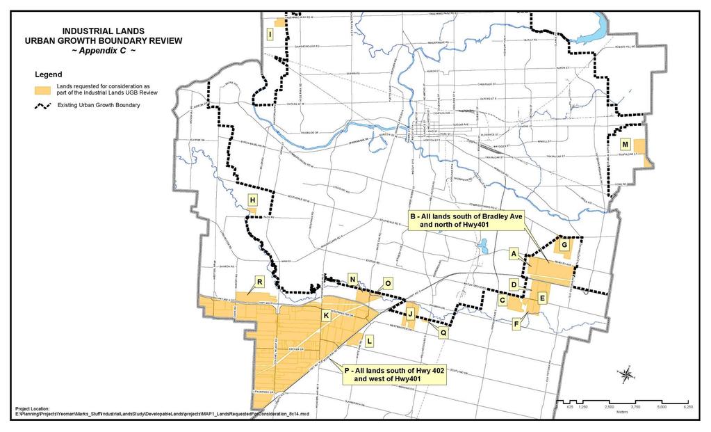
8 identified by Staff and the London Economic Development Corporation as potential industrial sites were assessed against the evaluation criteria developed in the Industrial Lands Study and ILDS. The evaluation criteria include the following objectives: Alignment with economic development objectives and priorities; Suitability/affordability of municipal servicing; Proximity to the Provincial Highways or Veterans Memorial Parkway; Site topography and configuration; Environmental/natural heritage constraints; Existing land use and compatibility issues; Landowner interest in development; Agricultural land considerations including agricultural land capability and MDS requirements; Suitability for the extension of transit service; Compact urban form/logical extension of the urban area; The return on investment in previous infrastructure projects; Parcel sizes and their suitability for land assembly; and The opportunity for spin-off benefits. Landowner Requested Properties Properties requested for consideration are shown in Appendix C, attached to this report. Properties requested for consideration through landowner submissions were evaluated against evaluation criteria, as outlined in the table below. The table shows a simple unweighted points scale from one (1) to three (3), with 1 representing the least favourable condition and 3 represents the most favourable condition. Hollow circles represent 1, half full circles represent 2, and solid circles represents 3. Properties requested for consideration were from the following addresses or areas and are identified alphabetically in the table below. A and 1913 Bradley Avenue; B. All lands south of Bradley Avenue and north of Hwy 401. C and 1687 Wilton Grove Road; D Wilton Grove Road; E. 1806, 1811 and 1874 Wilton Grove Drive; F Wilton Grove Road; G Commissioners Road East; H Pack Road; I Fanshawe Park Road West; J and 3356 Westminster Drive and 3045 Dingman Drive; K Westminster Drive; L Scotland Drive; M and 3085 Trafalgar Street; N White Oak Road; O White Oak Road; P. All lands south of Highway 402 and west of Highway 401; Q Wellington Road South; and R Murray Road. 8
9 Property Criteria A B C D E F G H I J K L M N O P Q R Meets requirements identified in recent inquiries/ attractions identified by LEDC Located within the 6 Strategic areas of ILDS Proximity to Hwy 401/402 or VMP Logical extension Contiguous to existing UGB Contiguous to existing Industrial Park Return on previous investments Exploits Highway interchanges Environmental constraints Servicing (capacity/ constraints) Compatibility with existing and Planned Uses Trigger Bradley Avenue interchange Potential residential conflict Parcel sizes and suitability for assembly Development or Acquisition concerns Long-term Industrial potential Simple Comparative Score Table 1: Summary of Evaluation of Landowner Requested Properties Requested sites demonstrated a range of locations, sizes, and degrees of alignment with the requirements of the Council-approved ILDS, which is the long-term strategy for industrial land acquisition, planning, development and marketing. Certain of the requested properties are in immediate adjacency to the City s successful Industrial Parks and provide for a logical extension of growth and servicing, help further the return on previous investments, provide spin-off benefits and enhance the marketability of growing Industrial Parks. Some of the candidate sites 9
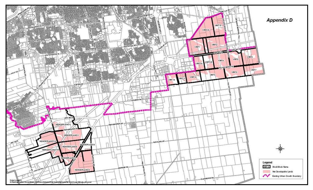
10 Criteria are located in the six strategic locational areas of the ILDS. Certain properties have frontage onto, and proximity to, the economic and investment corridor of the NAFTA highway and Veterans Memorial Parkway. Other requested candidate sites demonstrate locational limitations, servicing constraints or other constraints that limit the ability to meet the industrial marketplace s land requirements. Comprehensive Review of Larger Study Area Upon completion of the assessment of landowner requests, Staff widened the study area to assess additional lands that could potentially address the ILDS criteria for industrial land development. The study area is identified in Appendix D, attached to this report. The blocks of land identified in the study area of Appendix D were assessed against the same ILDS evaluation criteria as the landowner-requested properties. The findings of the study area assessment are summarized in the two tables that follow, which for reference are referred to as VMP Blocks for the eastern area and Wonderland Blocks for the western area. The same simple unweighted points scale from one (1) to three (3) is employed, with 1 representing the least favourable condition and 3 represents the most favourable condition. Hollow circles represent 1, half full circles represent 2, and solid circles represents 3. VMP Blocks 1 2 3A 3B Meets requirements identified in recent inquiries/attractions identified by LEDC Located within the 6 Strategic areas of ILDS Proximity to Hwy 401/402 or VMP Logical extension Contiguous to existing UGB Contiguous to existing Industrial Park Return on previous investments Exploits Highway interchanges Environmental constraints Servicing (capacity/ constraints) Compatibility with existing and Planned Land Uses Trigger Bradley Avenue interchange Potential residential conflict Parcel sizes and suitability for assembly Development or Acquisition concerns Long-term Industrial potential Simple Comparative Score (Rank) 35 (4) 39 (2) 41 (1) 28 (10) 31 (8) 32 (7) 41 (1) 33 (6) 34 (5) 31 (8) 41 (1) 41 (1) Table 2: Summary of Evaluation of the Eastern Portion of the Study Area ( VMP Blocks ) 29 (9) 33 (6) 38 (3) 10
11 Wonderland Blocks A 7B Criteria Meets requirements identified in recent inquiries/attractions identified by LEDC Located within the 6 Strategic areas of ILDS Proximity to Hwy 401/402 or VMP Logical extension Contiguous to existing UGB Contiguous to existing Industrial Park Return on previous investments Exploits Highway interchanges Environmental constraints Servicing (capacity/constraints) Compatibility with existing and Planned Land Uses Trigger Bradley Avenue interchange Potential residential conflict Parcel sizes and suitability for assembly Development or Acquisition concerns Long-term Industrial potential Simple Comparative Score (Rank) 32 (7) 32 (7) 29 (9) 29 (9) 29 (9) 29 (9) 32 (7) 32 (7) Table 3: Summary of Evaluation of the Western Portion of the Study Area ( Wonderland Blocks ) Further considerations for all candidate blocks of land include: environmental features; other City initiatives and potential impacts on those initiatives; potential for conflict with existing and planned uses including Agriculture or Community Growth areas; and the potential long-term viability of industrial uses in areas where significant requests for changes in land use have been addressed, including but not limited to the areas surrounding the Southwest Area Plan and White Oak Business Park study area. RECOMMENDED UGB EXPANSION AND NEXT STEPS In order to strategically capitalize on potential economic development opportunities, meet market land demands and trends, fulfil the land development goals of the ILDS, create spin-offs and further the return on previous investments in successful Industrial Parks, and logically and contiguously expand the Urban Growth Boundary, infrastructure and services, the UGB expansion identified in Schedule 1, attached, is recommended. This expansion also incorporates landowner requested areas with the highest scores on the evaluation, and therefore represents the most strategic locations to take advantage of potential economic development and employment opportunities over the next five (5) years. 11
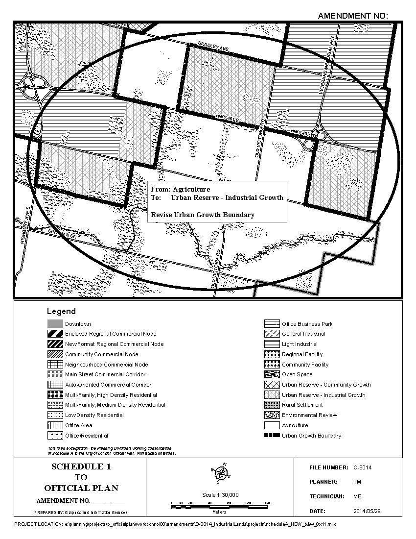
12 Areas were also reviewed against market intelligence provided by the London Economic Development Corporation regarding recent market interest and trends, as seen through recent inquiries about the City and attractions to the City. The market has demonstrated significant interest in large sites, in greenfield locations and in areas adjacent to Highway 401. Most companies recently inquiring are comparing London to municipalities further east towards the GTA and Greater Golden Horseshoe. As such, companies have shown strong interest in properties east of Highbury Avenue and shown limited interest in properties west of Highbury Avenue. Furthermore, the City of London also has a supply of vacant industrial land that is larger than the projected land demand for the next twenty (20) years. Under the 2014 Provincial Policy Statement, the maximum amount of land that may be designated for Industrial land use is a twenty (20) years supply. As such, the Urban Growth Boundary expansion is permitted based on the re-designation of Industrial lands to non-industrial land uses through related area planning and land needs reviews. Through such re-designations, the total land area designated for Industrial uses stays the same as it was prior to the re-designations of the related planning studies. The total expansion permitted is therefore approximately 300 hectares. This expansion maximizes Highway 401 frontage and exposure, extends and builds upon the Industrial Parks displaying sought-after attributes of the ILDS-targeted industrial sectors, including advanced manufacturing, Research, Development and Commercialization (R, D & C), agri-food processing, logistics and others. The proposed expansion of the UGB extends westward and southward from Innovation Park and southward and eastward from Forest City Industrial Park. The City may review land needs, including vacant supply and projected demands, every five (5) years as part of an Official Plan update. The recommended expansion meets the land development needs of the ILDS, and will be reviewed at a future date for the potential for further expansions for future industrial development. The proposed change in land use designation, identified in Schedule 1, is a change to Schedule A Land Use of the Official Plan. The change is to expand the Urban Growth Boundary and to redesignate lands within the expanded boundary in Schedule 1 from Agriculture designation to Urban Reserve Industrial Growth designation. Only the Agriculture designated lands are proposed for a change in land use. Environmental features, including those in Open Space and Environmental Review designations have been discounted from calculations for developable land areas and are not proposed for a change in land use. Appropriate studies will be required to determine buffers from environmental features. Required minimum distance separation (MDS) from existing livestock operations will also be adhered to because the city s livestock agriculture operations are a vital employer and economic sector of rural London and the surrounding agricultural region of Southwest Ontario. The proposed expansion is consistent with the Provincial Policy Statement 2014 and the City s Official Plan. The proposed Amendment will implement the Council-approved Industrial Land Development Strategy (ILDS) and ensure that the City has an adequate supply of industrial land at the appropriate size and in the appropriate locations to meet its industrial land demand requirements. 12
13 This report was developed with input from: Mark Johnson, Planner II; and Paul Yeoman, Manager I Development Finance. PREPARED BY: SUBMITTED BY: TRAVIS MACBETH, MCIP, RPP PLANNER II, LONG RANGE PLANNING AND RESEARCH GREGG BARRETT, AICP MANAGER, LONG RANGE PLANNING AND RESEARCH RECOMMENDED BY: JOHN M. FLEMING, MCIP, RPP MANAGING DIRECTOR, PLANNING AND CITY PLANNER May 30, 2014 TM/tm Attach. Y:\Shared\policy\CITY INITIATED FILES\8014O - UGB Industrial\PEC June 17, 2014 Staff Report - Industrial UGB Review.docx 13
14 Appendix "A" Bill No By-law No. C.P.1284( ) - A by-law to amend the Official Plan for the City of London, 1989, relating to Schedule A Land Use for the inclusion of lands within the Urban Growth Boundary and the change in use FROM Agriculture TO Urban Reserve Industrial Growth. follows: The Municipal Council of The Corporation of the City of London enacts as 1. Amendment No. to Schedule A Land Use of the Official Plan for the City of London Planning Area 1989, as contained the text attached hereto and forming part of this by-law, is adopted. 2. This by-law shall come into effect in accordance with subsection 17(38) of the Planning Act, R.S.O. 1990, c.p.13. PASSED in Open Council on June 24, Joe Fontana Mayor Catharine Saunders City Clerk First Reading June 24, 2014 Second Reading June 24, 2014 Third Reading June 24,
15 AMENDMENT NO. to the OFFICIAL PLAN FOR THE CITY OF LONDON A. PURPOSE OF THIS AMENDMENT The purpose of this Amendment is: 1. To amend Schedule A Land Use of the Official Plan, attached as Schedule 1, for inclusion of approximately 300 hectares of additional land within the Urban Growth Boundary (UGB) for industrial uses; and 2. To amend Schedule A Land Use of the Official Plan, to change the designation of the subject lands identified for inclusion in the UGB as amended by clause 1) above FROM Agriculture designation TO Urban Reserve-Industrial Growth designation, as identified in Schedule 1. B. LOCATION OF THIS AMENDMENT 1. This Amendment applies to land located north and south of Highway 401 near the Veterans Memorial Parkway and lands south and east of the Forest City Industrial Park, including lands south of Wilton Grove Road and east of the Highbury Avenue interchange and south of Highway 401 east of Cheese Factory Road, as identified in Schedule 1. C. BASIS OF THE AMENDMENT Based on a comprehensive review, including an assessment of industrial land supply, projected land need, and Official Plan amendments that have redesignated industrial lands to other land uses, an expansion of the Urban Growth Boundary (UGB) by approximately 300 hectares to accommodate future industrial growth is recommended. Proposed locations for expansion of the UGB to accommodate future industrial development are based on an evaluation of criteria that includes, but is not limited to, parcel sizes, locations, servicing, environmental and other constraints as well as market demands from target industrial sectors. D. THE AMENDMENT The Official Plan for the City of London is hereby amended as follows: 1. Schedule A - Land Use, to the Official Plan for the City of London Planning Area is amended by including approximately 300 hectares of additional lands within the Urban Growth Boundary (UGB) for industrial uses, as identified in attached Schedule 1; and 2. Schedule A - Land Use, to the Official Plan for the City of London Planning Area is amended by designating those lands identified for inclusion in the UGB in clause 1), above, located north and south of Highway 401 near the Veterans Memorial Parkway and lands south and east of the Forest City Industrial Park, including lands south of Wilton Grove Road and east of the Highbury Avenue interchange and south of Highway 401 east of Cheese Factory Road in the City of London, as indicated on Schedule 1 attached hereto, from Agriculture designation to Urban Reserve Industrial Growth designation. 15
16 16
17 Appendix "B" Location Map of White Oaks Business Park Study Area 17
18 18
19 Appendix C Properties Requested by Landowners to be considered for Inclusion in UGB 19
20 20
21 Appendix D Study Area for Industrial Lands Review 21
22 22
CHAIR AND MEMBERS PLANNING & ENVIRONMENT COMMITTEE JOHN M. FLEMING MANAGING DIRECTOR, PLANNING AND CITY PLANNER
 TO: FROM: SUBJECT: CHAIR AND MEMBERS PLANNING & ENVIRONMENT COMMITTEE JOHN M. FLEMING MANAGING DIRECTOR, PLANNING AND CITY PLANNER APPLICATION BY: THE CORPORATION OF THE CITY OF LONDON OUTDOOR PATIOS IN
9 CITY OF VAUGHAN OFFICIAL PLAN AMENDMENT NO BOCA EAST INVESTMENTS LIMITED
 9 CITY OF VAUGHAN OFFICIAL PLAN AMENDMENT NO. 631 - BOCA EAST INVESTMENTS LIMITED The Planning and Economic Development Committee recommends the adoption of the recommendations contained in the following
The Corporation of the Town of Milton
 Report To: From: Council Barbara Koopmans, Commissioner, Planning and Development Date: May 7, 2018 Report No: Subject: Making it Possible Positioning the Town s Strategy for Growth and Economic Development
6 Growth Management Challenges and Opportunities
 6 Growth Management Challenges and Opportunities The Town has established a goal of attaining a 50% participation rate with respect to employment opportunities versus residential population. The Town s
12 AMENDMENT NO. 149, TOWN OF MARKHAM HIGHWAY 404 NORTH SECONDARY PLAN
 12 AMENDMENT NO. 149, TOWN OF MARKHAM HIGHWAY 404 NORTH SECONDARY PLAN The Planning and Economic Development Committee recommends the adoption of the recommendation contained in the following report August
This page has been intentionally left blank.
 This page has been intentionally left blank. Chapter 3 3-2 3. Employment 3.A Niagara Economic Gateway 3.A.1 General The Niagara Economic Gateway comprises: a) The Gateway Economic Zone which includes all
MAYFIELD WEST SECONDARY PLAN PHASE 2
 MAYFIELD WEST SECONDARY PLAN PHASE 2 Public Open House #3 February 25, 2010 Draft Preferred Land Use Scenario TOWN OF CALEDON PLANNING & DEVELOPMENT DEPARTMENT Open House Agenda TOWN OF CALEDON 1. Welcome
Employment and Commercial Review Analysis of Policy Directions
 Employment and Commercial Review Analysis of Policy Directions Appendix A The following analysis is town staff s response to the policy directions provided by the consultants who prepared the Employment
The Corporation of the TOWN OF MILTON
 Report to: From: Chair & Members of the Administration & Planning Standing Committee W.F. Mann, Director of Planning and Development Date: April 16, 2012 PD 022-12 (Z19/11) Subject: Technical Report Proposed
Public Information Centre #1
 and Highway 401 Interchange Improvements WELCOME Public Information Centre #1 Veterans Memorial Parkway Extension and Highway 401 Interchange Improvements Study May 23, 2012 4 p.m. to 7 p.m. Brief Overview
ONTARIO MUNICIPAL BOARD
 PL 120483 ONTARIO MUNICIPAL BOARD Applicant/Appellant: 2124123 Ontario Limited Subject: OPA, Rezoning and Draft Plan of Subdivision Municipal Address: 3940 Highway 7 East Municipality: City of Markham
11 APPEAL BY LEBOVIC ENTERPRISES INC. AND REVLIS LTD. TO OFFICIAL PLAN AMENDMENT D , TOWN OF AURORA
 11 APPEAL BY LEBOVIC ENTERPRISES INC. AND REVLIS LTD. TO OFFICIAL PLAN AMENDMENT D09-09-03, TOWN OF AURORA The Planning and Economic Development Committee recommends the following: 1. The deputation by
THE CORPORATION OF THE TOWN OF OAKVILLE BY-LAW NUMBER
 THE CORPORATION OF THE TOWN OF OAKVILLE BY-LAW NUMBER 20012-08530 A by-law to adopt an amendment to the Official Plan of the Oakville Planning Area (Official Plan Amendment 198) Land North of Dundas Street.
Planning and Growth Management Committee. Chief Planner and Executive Director, City Planning Division. Pg12013 (File No NNY 34 OZ)
") 865 York Mills Road Official Plan Amendment Application Preliminary Report STAFF REPORT ACTION REQUIRED Date: February 28, 2012 To: From: Wards: Reference Number: Planning and Growth Management Committee
865 York Mills Road Official Plan Amendment Application Preliminary Report STAFF REPORT ACTION REQUIRED Date: February 28, 2012 To: From: Wards: Reference Number: Planning and Growth Management Committee
THAT the attached Terms of Reference for the Thornhill Centre Street Study be approved.
 COMMITTEE OF THE WHOLE AUGUST 18, 2003 THORNHILL CENTRE STREET STUDY PLANNING FILE: 15.92 Recommendation The Commissioner of Planning recommends: THAT the attached Terms of Reference for the Thornhill
Queen Street West - Zoning Amendment Application - Preliminary Report
 STAFF REPORT ACTION REQUIRED 944-952 Queen Street West - Zoning Amendment Application - Preliminary Report Date: February 6, 2013 To: From: Wards: Reference Number: Toronto and East York Community Council
Bostwick Road. Municipal Class Environmental Assessment. October 13, City of London. Bostwick Road Municipal Class Environmental Assessment
 Bostwick Road Municipal Class Environmental Assessment October 13, 2016 Welcome! Welcome to the first Public Information Centre for the Bostwick Road Municipal Class Environmental Assessment. Representatives
Edward R. Sajecki Commissioner of Planning and Building. Land Use Review- Former Parkway Belt West Lands- Fieldgate Drive and Audubon Boulevard
 Corporate Report Clerk s Files Originator s Files CD.04.FOR DATE: November 15, 2011 TO: FROM: SUBJECT: Chair and Members of Planning and Development Committee Meeting Date: December 5, 2011 Edward R. Sajecki
Report to: Development Services Committee Report Date: September 11, 2017
 ~RKHAM Report to: Development Services Committee Report Date: September 11, 2017 SUBJECT: PREPARED BY: Conceptual Master Plan for the Future Urban Area - Community Structure Plan and Key Policy Direction
CITY CLERK. Parkland Acquisition Strategic Directions Report (All Wards)
") CITY CLERK Clause embodied in Report No. 10 of the, as adopted by the Council of the City of Toronto at its meeting held on November 6, 7 and 8, 2001. 10 Parkland Acquisition Strategic Directions Report
CITY CLERK Clause embodied in Report No. 10 of the, as adopted by the Council of the City of Toronto at its meeting held on November 6, 7 and 8, 2001. 10 Parkland Acquisition Strategic Directions Report
Services Department B September 10, 2007
 Report To: Development Services Committee Item: Date of Report: DS-07-246 September 5, 2007 From: Commissioner, Development File: Date of Meeting: Services Department B7200-0001 September 10, 2007 Subject:
PDS June 1, 2016 Page 1. Planning and Development Committee. MEETING DATE: Wednesday, June 01, 2016
 Page 1 REPORT TO: Planning and Development Committee MEETING DATE: Wednesday, June 01, 2016 SUBJECT: ROPA 12: Project Initiation Report Regional Official Plan Amendment (ROPA # 12) Watercourse Policies
MAYFIELD WEST SECONDARY PLAN PHASE 2
 MAYFIELD WEST SECONDARY PLAN PHASE 2 Council Information Workshop February 16, 2010 Draft Preferred Land Use Plan TOWN OF CALEDON PLANNING & DEVELOPMENT DEPARTMENT Workshop Agenda TOWN OF CALEDON 1. Welcome
John M. Fleming Managing Director, Planning and City Planner. Old East Village Dundas Street Corridor Secondary Plan Draft Terms of Reference
 Report to Planning and Environment Committee To: From: Subject: Chair and Members Planning & Environment Committee John M. Fleming Managing Director, Planning and City Planner Old East Village Dundas Street
1 Introduction. Chapter. In this chapter:
 Chapter 1 Introduction In this chapter: 1.1 A Snapshot of the Region 1.2 Towards a Sustainable Region 1.3 The Provincial Context 1.4 Purpose and Organization The Regional Municipality of York Official
Woodburn Comprehensive Plan Growth Management Goals and Policies
 Goal Woodburn Comprehensive Plan Growth Management Goals and Policies G-1. The City's goal is to manage growth in a balanced, orderly and efficient manner, consistent with the City s coordinated population
Official Plan Amendment for Scarborough Rapid Transit (SRT) Extension Final Report
 Extension Final Report") STAFF REPORT ACTION REQUIRED Official Plan Amendment for Scarborough Rapid Transit (SRT) Extension Final Report Date: April 27, 2010 To: From: Wards: Reference Number: Planning and Growth Management Committee
STAFF REPORT ACTION REQUIRED Official Plan Amendment for Scarborough Rapid Transit (SRT) Extension Final Report Date: April 27, 2010 To: From: Wards: Reference Number: Planning and Growth Management Committee
Official Plan Review
 Official Plan Review Summary Report - The Built Environment August 2014 Part 1: Introduction Planning for a healthy, prosperous and sustainable community is an important goal for our municipality. From
St. Lawrence Neighbourhood Focused Area - Official Plan Amendment Status Report
 STAFF REPORT ACTION REQUIRED St. Lawrence Neighbourhood Focused Area - Official Plan Amendment Status Report Date: May 21, 2015 To: From: Wards: Reference Number: Toronto and East York Community Council
Intention to Designate under Part IV, Section 29 of the Ontario Heritage Act 844 Don Mills Road and 1150 Eglinton Avenue East
 STAFF REPORT ACTION REQUIRED Intention to Designate under Part IV, Section 29 of the Ontario Heritage Act 844 Don Mills Road and 1150 Eglinton Avenue East Date: September 7, 2016 To: From: Toronto Preservation
2. Shaping Waterloo Region s Urban Communities
 2. Much of the region s growth over the past several decades has occurred in suburban areas that separated where people live from where they work and shop. This pattern of growth has increased the need
8 Oak Street - Official Plan and Zoning By-law Amendment Application - Preliminary Report
 STAFF REPORT ACTION REQUIRED 8 Oak Street - Official Plan and Zoning By-law Amendment Application - Preliminary Report Date: March 17, 2014 To: From: Wards: Reference Number: Planning and Growth Management
Presentation Outline. Southwest Area Plan. Slide 1. Slide 2. Presentation to the Committee of the Whole. September 20, 2011
 Slide 1 Southwest Area Plan Presentation to the Committee of the Whole September 20, 2011 Slide 2 Presentation Outline City-Wide Growth Planning Link Official Plan Policies Current Situation and Projections
Edward R. Sajecki Commissioner of Planning and Building
 Corporate Report Clerk s Files Originator s Files CD.03.POR DATE: TO: FROM: SUBJECT: Chair and Members of Planning and Development Committee Meeting Date: February 27, 2012 Edward R. Sajecki Commissioner
Master Environmental Servicing Plan & Secondary Plan
 East Side Lands Stage 2 1 Master Environmental Servicing Plan & Secondary Plan Public Information Centre #1 June 16, 2016 Welcome! Today s Agenda Please sign in at the front desk. 5:30 pm 6:30 pm: Open
COLVER ROAD INDUSTRIAL CONCEPT PLAN
 COLVER ROAD INDUSTRIAL CONCEPT PLAN A CONCEPTUAL LAND USE AND TRANSPORTATION PLAN FOR TA-4 AN URBAN RESERVE AREA OF THE CITY TALENT City of Talent Adopted by City Council Resolution No., June, 2015 PART
Master Environmental Servicing Plan & Secondary Plan
 1 East Side Lands Stage 2 Master Environmental Servicing Plan & Secondary Plan Public Consultation Centre #4 March 20, 2018 Welcome! Today s Agenda Please sign in at the registration table. 6:00 pm 6:30
CONSULTING SERVICES FOR THE WHITEBELT VISIONING EXERCISE ADDENDUM TO THE GTA WEST LAND USE STUDY WORK PROGRAM
 CONSULTING SERVICES FOR THE WHITEBELT VISIONING EXERCISE ADDENDUM TO THE GTA WEST LAND USE STUDY 1. Introduction WORK PROGRAM The Town of Caledon is a large, local municipality located in the Greater Toronto
HEMSON IV EMPLOYMENT LAND CONVERSION
 28 IV EMPLOYMENT LAND CONVERSION The appropriateness of permitting changes to the City s employment land supply is considered within the context of the adequacy of the supply to accommodate growth projected
Growing Community Urban Settlement Area and Hidden Valley Settlement Area
 Town of Huntsville Official Plan Review - POLICY BACKGROUND PAPER Growing Community Urban Settlement Area and Hidden Valley Settlement Area BACKGROUND: Through the Provincial Policy Statement (PPS), the
1-17 Anndale Drive, Bales Avenue and Glendora Avenue Zoning Amendment Application Preliminary Report
 STAFF REPORT ACTION REQUIRED 1-17 Anndale Drive, 31-35 Bales Avenue and 22-70 Glendora Avenue Zoning Amendment Application Preliminary Report Date: August 20, 2007 To: From: Wards: Reference Number: North
Town of Newmarket 395 Mulock Drive P.O. Box 328, Newmarket, Ontario, L3Y 4X7. Website: newmarket.ca Phone:
 Town of Newmarket 395 Mulock Drive P.O. Box 328, Newmarket, Ontario, L3Y 4X7 Email: info@newmarket.ca Website: newmarket.ca Phone: 905-895-5193 Natural Heritage System Boundary Refinement: Vacant Lot West
and Richmond Street West - Official Plan Amendment Application - Preliminary Report
 STAFF REPORT ACTION REQUIRED 822-838 and 860-862 Richmond Street West - Official Plan Amendment Application - Preliminary Report Date: August 14, 2017 To: From: Wards: Reference Number: Toronto and East
The Regional Municipality of Halton. Chair and Members of the Planning and Public Works Committee
 The Regional Municipality of Halton Report To: From: Chair and Members of the Planning and Public Works Committee Art Zuidema, Commissioner, Legislative and Planning Services Date: October 4, 2017 Report
30 and 44 Zorra Street - Zoning By-law Amendment Application - Preliminary Report
 STAFF REPORT ACTION REQUIRED 30 and 44 Zorra Street - Zoning By-law Amendment Application - Preliminary Report Date: March 14, 2016 To: From: Wards: Reference Number: Etobicoke York Community Council Director,
SUBJECT: Revised proposed new official plan recommended for adoption
 Page 1 of Report PB-04-18 SUBJECT: Revised proposed new official plan recommended for adoption TO: FROM: Planning and Development Committee Department of City Building Report Number: PB-04-18 Wards Affected:
DRAFT. & Secondary Plan Study. East Side Lands- Stage 2. Planning Rationale Report
 East Side Lands- Stage 2 Master Environmental SERVICING Plan & Secondary Plan Study Planning Rationale Report Draft April 24, 2018 QUALITY MANAGEMENT Issue/Revision First Issue Revision 1 Revision 2 Remarks
3 TOWN OF WHITCHURCH-STOUFFVILLE OFFICIAL PLAN AMENDMENT NOS. 116 & 117
 3 TOWN OF WHITCHURCH-STOUFFVILLE OFFICIAL PLAN AMENDMENT NOS. 116 & 117 The Planning and Economic Development Committee recommends the adoption of the recommendations contained in the following report,
NEW REGIONAL OFFICIAL PLAN HIGH LEVEL PROCESS & FRAMEWORK
 NEW REGIONAL OFFICIAL PLAN HIGH LEVEL PROCESS & FRAMEWORK Why A New Official Plan Originally the role of Regionally Planning and content of Regional Official Plan (1970s) primarily focused on protecting
WITNESS STATEMENT Of. Ronald Blake. On behalf of the Intervenor The Corporation of the City of Markham
 Filed: 2013-06028 EB-2012-0451 Exhibit L.EGD.COM.2 Page 1 of 7 WITNESS STATEMENT Of Ronald Blake On behalf of the Intervenor The Corporation of the City of Markham In the matter of an application by Enbridge
Land Use Amendment in Southwood (Ward 11) at and Elbow Drive SW, LOC
 at and Elbow Drive SW, LOC") 2018 November 15 Page 1 of 10 EXECUTIVE SUMMARY This land use amendment application was submitted by Rick Balbi Architect on 2017 August 31 on behalf of Sable Developments Ltd, and with authorization from
2018 November 15 Page 1 of 10 EXECUTIVE SUMMARY This land use amendment application was submitted by Rick Balbi Architect on 2017 August 31 on behalf of Sable Developments Ltd, and with authorization from
Official Plan Review: Draft Built Form Policies
 PG.30.1 REPORT FOR ACTION Official Plan Review: Draft Built Form Policies Date: May 15, 2018 To: Planning and Growth Management Committee From: Chief Planner and Executive Director, City Planning Division
1.0 PLANNING MARKHAM S FUTURE CONTENTS
 1-1 Planning Markham s Future 1.0 PLANNING MARKHAM S FUTURE CONTENTS 1.1 THE PURPOSE OF THE OFFICIAL PLAN 1.2 THE MARKHAM CONTEXT 1.3 THE REGULATORY CONTEXT 1.3.1 Province of Ontario 1.3.2 York Region
4121 Lawrence Avenue East Rezoning Application Preliminary Report
 STAFF REPORT ACTION REQUIRED 4121 Lawrence Avenue East Rezoning Application Preliminary Report Date: October 11, 2011 To: From: Wards: Reference Number: Scarborough Community Council Director, Community
Figure 1- Site Plan Concept
 Figure 1- Site Plan Concept Parking will be provided underground on three levels at rate of 1.0 space/ unit; this rate includes all visitors parking. MMM Group has prepared a parking assessment (April,
THE CORPORATION OF THE TOWN OF OAKVILLE BY-LAW NUMBER
 THE CORPORATION OF THE TOWN OF OAKVILLE BY-LAW NUMBER 2017-120 A by-law to adopt an amendment to the Livable Oakville Plan, Official Plan Amendment Number 20 (Downtown Oakville Growth Area) WHEREAS the
20 & 50 Ashtonbee Road, 1920 & 1940 Eglinton Avenue East, and 880, 890 & 900 Warden Avenue Zoning Amendment Application Final Report
 STAFF REPORT ACTION REQUIRED 20 & 50 Ashtonbee Road, 1920 & 1940 Eglinton Avenue East, and 880, 890 & 900 Warden Avenue Zoning Amendment Application Final Report Date: August 16, 2012 To: From: Wards:
Goal 14 Urbanization
 Urbanization The residents of Benton County value the rural character that still exists in much of the County, the distinction that has been maintained between settlement areas and resource lands and open
112 College Street Zoning Amendment Application Preliminary Report
 ~TORONTO REPORT FOR ACTION 112 College Street Zoning Amendment Application Preliminary Report Date: January 25, 2019 To: Toronto and East York Community Council From: Director, Community Planning, Toronto
646 Kingston Road - Official Plan Amendment and Zoning Amendment Applications - Preliminary Report
 STAFF REPORT ACTION REQUIRED 646 Kingston Road - Official Plan Amendment and Zoning Amendment Applications - Preliminary Report Date: December 8, 2014 To: From: Wards: Reference Number: Toronto and East
Report Regarding Site Plan Control for 55 Wellspring Way (File No. SP-06-16)
") Report Regarding Site Plan Control for 55 Wellspring Way (File No. SP-06-16) Executive Summary: The purpose of this report is to provide Council with information regarding site plan control under Section
Report Regarding Site Plan Control for 55 Wellspring Way (File No. SP-06-16) Executive Summary: The purpose of this report is to provide Council with information regarding site plan control under Section
Sustainable Growth. Sustainable Growth
 2 Sustainable Growth Sustainable Growth SUSTAINABLE GROWTH 2.1 COMMUNITY VISION... 2-5 2.2 THE CITY SYSTEM... 2-7 2.2.1 AREAS... 2-7 2.2.2 CITY-WIDE SYSTEMS... 2-8 2.2.3 PROVINCIAL PLAN BOUNDARIES AND
2450 Victoria Park Avenue Official Plan Amendment Application Preliminary Report
 STAFF REPORT ACTION REQUIRED 2450 Victoria Park Avenue Official Plan Amendment Application Preliminary Report Date: December 19, 2012 To: From: Wards: Reference Number: Planning and Growth Management Committee
Eglinton Avenue East & 50 Thermos Road - Official Plan Amendment Application Preliminary Report
 STAFF REPORT ACTION REQUIRED 1966 2050 Eglinton Avenue East & 50 Thermos Road - Official Plan Amendment Application Preliminary Report Date: March 15, 2016 To: From: Wards: Reference Number: Scarborough
STUDY AREA LOCATION & CONTEXT:
 UNLOCKING THE POTENTIAL OF THE KEATING CROSS ROAD BUSINESS CORRIDOR A PLAN TO CREATE + RETAIN JOB-GENERATING BUSINESSES AND TO GUIDE INFRASTRUCTURE INVESTMENT The Keating Cross Road Corridor (the Keating
240 and 242 Finch Avenue West Zoning By-law Amendment Application Preliminary Report
 REPORT FOR ACTION 240 and 242 Finch Avenue West Zoning By-law Amendment Application Preliminary Report Date: March 1, 2019 To: North York Community Council From: Director, Community Planning, North York
The West Vaughan Employment Area Secondary Plan Policies
 Part 2: The West Vaughan Employment Area Secondary Plan Policies 2.1 General Policies It is the policy of Council: 2.1.1. That the West Vaughan Employment Area (the WVEA), identified on Schedule 1, will
THE CITY OF VAUGHAN BY-LAW BY-LAW NUMBER A By-law to adopt Amendment Number 1 to the Official Plan of the Vaughan Planning Area.
 THE CITY OF VAUGHAN BY-LAW BY-LAW NUMBER 015-2014 A By-law to adopt Amendment Number 1 to the Official Plan of the Vaughan Planning Area. NOW THEREFORE the Council of the Corporation of the City of Vaughan
1.0 Purpose of a Secondary Plan for the Masonville Transit Village
 Report to Planning and Environment Committee To: Chair and Members Planning & Environment Committee From: John M. Fleming Managing Director, Planning and City Planner Subject: Masonville Transit Village
1120 Haist Street - Pelham Arena Community Co-Design Recommendation Report Haist Street - Pelham Arena Community Co-Design Recommendation Report
 1120 Haist Street - Pelham Arena Community Co-Design Executive Summary: In May, 2017 the Town retained the services of The Planning Partnership to undertake a community design charrette process to determine
PSRC REVIEW REPORT & CERTIFICATION RECOMMENDATION
 PSRC REVIEW REPORT & CERTIFICATION RECOMMENDATION KITSAP COUNTY COUNTYWIDE PLANNING POLICIES July 2, 2012 BACKGROUND A major emphasis of the Washington State Growth Management Act (GMA) is the need to
TOWN OF BRUDERHEIM Report to the capital region board
 TOWN OF BRUDERHEIM Report to the capital region board Introduction to the Town of Bruderheim Municipal Development Plan amendment and Relation to the CRB Evaluation Criteria 02 march 2017 1 Introduction
Director, Community Planning, North York District
 STAFF REPORT ACTION REQUIRED Oakwood Avenue Arts District Official Plan Amendment Final Report Date: September 12, 2008 To: From: Wards: Reference Number: North York Community Council Director, Community
844 Don Mills Road & 1150 Eglinton Avenue East - Official Plan Amendment Application - Preliminary Report
 STAFF REPORT ACTION REQUIRED 844 Don Mills Road & 1150 Eglinton Avenue East - Official Plan Amendment Application - Preliminary Report Date: July 10, 2014 To: From: Wards: Reference Number: Planning and
2 STATUTORY PUBLIC MEETING AND INFORMATION REPORT FOR PUBLIC MEETING ON AMENDMENT NO. 62 TO THE YORK REGION OFFICIAL PLAN
 2 STATUTORY PUBLIC MEETING AND INFORMATION REPORT FOR PUBLIC MEETING ON AMENDMENT NO. 62 TO THE YORK REGION OFFICIAL PLAN Pursuant to Section 17(15) of the Planning Act, as amended, the Regional Planning
Emery Village Road 2A Municipal Class Environmental Assessment Study
 PW12.11 STAFF REPORT ACTION REQUIRED Emery Village Road 2A Municipal Class Environmental Assessment Study Date: March 30, 2016 To: From: Wards: Reference Number: Public Works and Infrastructure Committee
PLANNING JUSTIFICATION REPORT
 PLANNING JUSTIFICATION REPORT 55 DELHI STREET CITY OF GUELPH PREPARED FOR: VESTERRA PROPERTY MANAGEMENT PREPARED BY: LABRECHE PATTERSON & ASSOCIATES INC. SCOTT PATTERSON, BA, CPT, MCIP, RPP PRINCIPAL,
POLICY AMENDMENT AND LAND USE AMENDMENT KILLARNEY/GLENGARRY (WARD 8) NW CORNER OF RICHMOND ROAD AND 33 STREET SW BYLAWS 1P2015 AND 7D2015
 NW CORNER OF RICHMOND ROAD AND 33 STREET SW BYLAWS 1P2015 AND 7D2015") Page 1 of 13 EXECUTIVE SUMMARY This application seeks to redesignate an RC-2 (Residential Contextual One/Two Dwelling) parcel to MC-Gd72 (Multi-Residential Contextual Grade-Oriented) to allow for multi-residential
Page 1 of 13 EXECUTIVE SUMMARY This application seeks to redesignate an RC-2 (Residential Contextual One/Two Dwelling) parcel to MC-Gd72 (Multi-Residential Contextual Grade-Oriented) to allow for multi-residential
8 & 10 Donalda Crescent Official Plan & Rezoning Application Final Report
 STAFF REPORT ACTION REQUIRED 8 & 10 Donalda Crescent Official Plan & Rezoning Application Final Report Date: July 26, 2010 To: From: Wards: Reference Number: Scarborough Community Council Director, Community
Official Plan Amendment to Further Protect Heritage Views of City Hall, Old City Hall and St. James Cathedral - Preliminary Report
 STAFF REPORT ACTION REQUIRED Official Plan Amendment to Further Protect Heritage Views of City Hall, Old City Hall and St. James Cathedral - Preliminary Report Date: June 6, 2017 To: From: Toronto and
Cc~tporate Sers~ic:es
 tg * Cc~tporate Sers~ic:es Csrmcil and Adnrirristrativs Services April 26,201 1 ". RE(;lr?N (1;. 1q.1 i Town of Caledon Region of Peel ci E~iliS DEP? Attn: Karen Landry, Director of Attn: Carol Reig, Regional
ADMINISTRATION RECOMMENDATION(S) 2018 January 25. That Calgary Planning Commission recommend APPROVAL of the proposed Land Use Amendment.
 2018 January 25. That Calgary Planning Commission recommend APPROVAL of the proposed Land Use Amendment.") Page 1 of 9 EXECUTIVE SUMMARY This land use amendment proposes to redesignate a parcel from DC Direct Control District to Multi-Residential Contextual Grade-Oriented (M-CG) District to allow for multi-residential
Page 1 of 9 EXECUTIVE SUMMARY This land use amendment proposes to redesignate a parcel from DC Direct Control District to Multi-Residential Contextual Grade-Oriented (M-CG) District to allow for multi-residential
LU Encourage schools, institutions, and other community facilities that serve rural residents to locate in neighboring cities and towns.
 Application No. 891627: Comprehensive Plan Text Amendment - Rural School Policies - Amend policies consistent with State Legislation allowing schools in the rural area and extension of sewer service to
LAND USE AMENDMENT CORNERSTONE (WARD 3) 60 STREET NE AND COUNTRY HILLS BOULEVARD NE MAP 26NE BYLAW 22D2017
 60 STREET NE AND COUNTRY HILLS BOULEVARD NE MAP 26NE BYLAW 22D2017") Page 1 of 14 EXECUTIVE SUMMARY This Land Use Amendment application covers an area of 43.76 hectares ± (108.14 acres ±) located in northeast Calgary, bound by Country Hills Boulevard NE to the south and
Page 1 of 14 EXECUTIVE SUMMARY This Land Use Amendment application covers an area of 43.76 hectares ± (108.14 acres ±) located in northeast Calgary, bound by Country Hills Boulevard NE to the south and
Edward R. Sajecki Commissioner of Planning and Building. Region of Halton Proposed Regional Official Plan Amendment for 5768 Ninth Line
 Corporate Report Clerk s Files Originator s Files MG.11.MIL DATE: TO: FROM: SUBJECT: Chair and Members of Planning and Development Committee Meeting Date: April 3, 2006 Edward R. Sajecki Commissioner of
General Committee Presentation. Paddy Kennedy, MCIP, RPP Dillon Consulting Limited
 General Committee Presentation Paddy Kennedy, MCIP, RPP Dillon Consulting Limited November 2012 Location of Area 3 Fitch St. Prince Charles Dr. Area 3 First Ave Thorold Rd. Study Purpose At the time that
13 THORNHILL YONGE STREET STUDY IMPLEMENTATION CITY OF VAUGHAN OPA 669 AND TOWN OF MARKHAM OPA 154
 13 THORNHILL YONGE STREET STUDY IMPLEMENTATION CITY OF VAUGHAN OPA 669 AND TOWN OF MARKHAM OPA 154 The Planning and Economic Development Committee recommends the adoption of the recommendations contained
1071 King Street West Zoning Amendment Application - Preliminary Report
 STAFF REPORT ACTION REQUIRED 1071 King Street West Zoning Amendment Application - Preliminary Report Date: August 9, 2012 To: From: Wards: Reference Number: Toronto and East York Community Council Director,
II PREVIOUS REPORTS PERTINENT TO THIS MATTER II
 ~ ~~ ~~~ ~ ~~ ~ ~~~~ ~ ~~ ~~ ~~~~ ~ Agenda Item # Page # TO: FROM: -..-.-I- 3UBJCL I CHAIR AND MEMBERS ENVIRONMENT AND TRANSPORTATION COMMITTEE MEETING ON OCTOBER 17,2005 DAVID A. LECKIE, P. ENG DIRECTOR
K. SMART ASSOCIATES LIMITED
 Planning Justification Report Zoning By-Law Amendment 185 King Street North Waterloo, Ontario April 7th, 2017 Project Reference Number 16-245 K. SMART ASSOCIATES LIMITED CONSULTING ENGINEERS AND PLANNERS
141 GEORGE STREET PLANNING RATIONALE
 141 GEORGE STREET PLANNING RATIONALE MINOR ZONING BY-LAW AMENDMENT NOVEMBER 2, 2016 PLANNING RATIONALE 223 McLeod Street Ottawa, ON K2P 0Z8 613.730.5709 fotenn.com INTRODUCTION FOTENN Consultants is acting
Draft Amendment Provides details regarding ROPA 47 s purpose and effect. Related Processes Highlights other ongoing processes of note in the area
 An Amendment to Address a Shortfall of Employment Lands in the Town of Halton Hills Premier Gateway Employment Area Public nformation Centre Wednesday November 1, 2017 6:30p.m. - 8:30p.m. Hillcrest United
Background Summary Report
 Background Summary Report May 2014 Submitted by Macaulay Shiomi Howson Ltd. In association with AMEC MMM Group Brook McIlroy Inc. Hemson Consulting Ltd. Table of Contents 1. Introduction... 1 2. Why is
11.4 Highway 400 North Employment Lands Secondary Plan APPROVED BY THE ONTARIO MUNICIPAL BOARD ON NOVEMBER 21, 2011
 11.4 Highway 400 North Employment Lands Secondary Plan APPROVED BY THE ONTARIO MUNICIPAL BOARD ON NOVEMBER 21, 2011 11.4.1 General 11.4.1.1. as approved by the Ontario Municipal Board on November 21, 2011,
Variation No 1: Dundalk & Environs Development Plan Core Strategy
 Variation No 1: Dundalk & Environs Development Plan 2009-2015 Core Strategy Adopted on 29 th August 2011 CONTENTS Page Section 1 1.0 Synopsis 1 1.1 Background Document 1 1.2 Variation of Dundalk and Environs
SUBJECT: Proposed Downtown Mobility Hub Precinct Plan and Proposed Official Plan Policies
 Page 1 of Report PB-81-17 SUBJECT: Proposed Downtown Mobility Hub Precinct Plan and Proposed Official Plan Policies TO: FROM: Committee of the Whole Planning and Building Department Report Number: PB-81-17
HEMSON C o n s u l t i n g L t d.
 INVENTORY & ASSESSMENT OF INTENSIFICATION OPPORTUNITIES City of Brampton Discussion i Paper for Public Review C o n s u l t i n g L t d. November 2008 EXECUTIVE SUMMARY This report is one of the key background
5 TOWN OF MARKHAM OFFICIAL PLAN AMENDMENT NO. 144 MILLIKEN MAIN STREET SECONDARY PLAN
 5 TOWN OF MARKHAM OFFICIAL PLAN AMENDMENT NO. 144 MILLIKEN MAIN STREET SECONDARY PLAN The Planning and Economic Development Committee recommends the following: 1. The communication from Brendan O Callaghan,
22 Metropolitan Rd - Official Plan Amendment Application - Preliminary Report
 STAFF REPORT ACTION REQUIRED 22 Metropolitan Rd - Official Plan Amendment Application - Preliminary Report Date: January 29, 2013 To: From: Wards: Planning and Growth Management Committee Chief Planner
6 AMENDMENT NO. 637 TO THE VAUGHAN OFFICIAL PLAN (VAUGHAN 400 NORTH EMPLOYMENT AREA SECONDARY PLAN)
") Report No. 3 of the Planning and Economic Development Committee Regional Council Meeting of March 24, 2011 6 AMENDMENT NO. 637 TO THE VAUGHAN OFFICIAL PLAN (VAUGHAN 400 NORTH EMPLOYMENT AREA SECONDARY
Report No. 3 of the Planning and Economic Development Committee Regional Council Meeting of March 24, 2011 6 AMENDMENT NO. 637 TO THE VAUGHAN OFFICIAL PLAN (VAUGHAN 400 NORTH EMPLOYMENT AREA SECONDARY