CITY OF NORCROSS LILLIAN WEBB PARK REDEVELOPMENT AREAS
|
|
|
- Gavin Holland
- 5 years ago
- Views:
Transcription
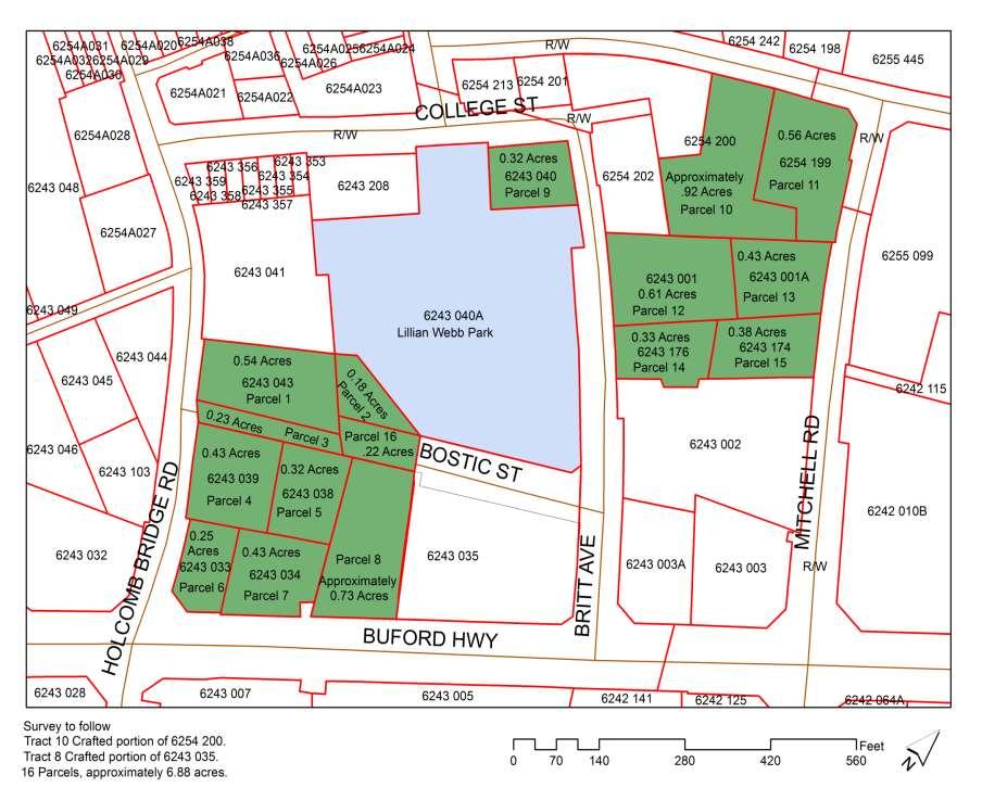
1 7/2/2016 CITY OF NORCROSS LILLIAN WEBB PARK REDEVELOPMENT AREAS 2016 Potential Development Around Lillian Webb Park The Lillian Webb Park Development Project is located north of Buford Highway; east of Holcomb Bridge Road; west of Britt Avenue and south of College Street, Norcross City Hall, and the historic downtown area. Proposed sites are well-matched for investment, and the locations are attractive development areas, as they are central to city amenities- in particular, Historic Downtown Norcross. Each site has an existing infrastructure of utilities, roads, sidewalks, etc. The corner of Buford Highway and Holcomb Bridge Road has been established by staff and council as a recognized gateway. Landmarks will be placed within the short-term.

, developed in 2008- is a four-acre park offering an interactive fountain/splash pad, stone tiered waterfall and plaza, gazebo and public")

2 Lillian Webb Redevelopment Areas Lillian Webb Park Development Objectives/Overview The City of Norcross/Downtown Development Authority is seeking design-build development proposals for a mixed-use development around Lillian Webb Park, furthering an investment into our city and its people. Emphasis will be placed on mixed-use (retail, office, living), to improve and complement existing structures. Lillian Webb Park (named after the City s mayor emeritus), developed in is a four-acre park offering an interactive fountain/splash pad, stone tiered waterfall and plaza, gazebo and public bathrooms. The park is central to the Project area and is considered value-added. The park is constantly in use by both residents and visitors, and is considered our community center. It is estimated to have 750 thousand+ users, per year-a plus for retail development! The project will include strategies and measurable metrics for new building around the park. Sixteen (16) parcels are included in the build, totaling 6.88 plus/minus acres. The parcels are owned/managed by the Downtown Development Authority of Norcross through IGAs with the City. Parcel numbers, maps, and individual acreage are found throughout this Plan. To promote development, a TAD (Tax Allocation District-see description, page 10) has been created. The TAD allows the City to assist with parking structures and stormwater infrastructure upgrades or installation. Utilities, some sidewalks and certain environmental studies are already considered complete. Council has given direction as to project included parcels, building heights, etc. These parameters may be found, beginning page 5. The Project focuses on the north and south areas surrounding Lillian Webb Park. Completed, it will become our new urban center. Mixed-use commercial, office and residential complexes, completed as one development, and constructed simultaneously, is the City s preference. pg. 1
3 Other new planned amenities include a proposed 22,000 sq. ft. regional library with lower level parking. The library parking deck will be built with possible underground connectivity to a developer s parking deck. This would create better ingress and egress for both projects, with entrance/exits at Britt Avenue and Buford Highway. The library building is in cooperation with Gwinnett County and is NOT included in this RFP, but mentioned to show other value-added improvements. An additional 150+ space multi-level parking deck near the corner of Britt and College Street is desired within the development, along with possible additional building atop the deck. It is expected this project will become the catalyst for continued growth throughout the city, but in particular, the entire width of our city, along Buford Highway. All public-private initiatives that enhance our vision or improve project completion will be considered. Parcel boundaries are drawn as an overview of the proposed project and are for comprehension purposes, only. They do not represent an exact area. A total survey has been performed. All coordinates and boundary lines will be agreed during deliberation with the chosen developer. RFP Timeline Summary, timeline and instructions are found: Bid Posting pg. 2
 pg.")
4 NEW LIBRARY SITE PROPOSED DEVELOPMENT BUFORD HIGHWAY PROPOSED DEVELOPMENT CURRENT LILLIAN WEBB PARK-OVERLOOKING PROPOSED PROJECT SOUTH AREA at BUFORD HIGHWAY (AREA AT TREE LINE as MARKED) pg. 3
5 Project- North Historic Downtown COLLEGE ST. Parcel boundaries are drawn as an overview of the proposed project, and are for comprehension purposes, only. They do not represent an exact area. A total survey has been performed. All coordinates and boundary lines will be agreed during deliberation with the chosen developer. The northern end of the project consists of seven (7) parcels: 9. Tax Id# , 0.32 acres 10. Tax Id# (crafted parcel), 0.92 acres 11. Tax Id# , 0.56 acres 12. Tax Id# , 0.61 acres 13. Tax Id# A, 0.43 acres 14. Tax Id# , 0.33 acres 15. Tax Id# , 0.38 acres Parcel #9 is closest to the historic downtown area and Norcross City Hall. Development of this parcel is reserved for commercial improvement which may include restaurants, shopping, etc. Parcel #9 is closest to the town center and has the greatest visibility to/from the downtown area. Adjacent to parcel #9 (at left) is the entrance to Lillian Webb Park, a series of fountains, splash pad and gazebo. Parcel #9 had significant rock blasting during the construction of the park splash pad and waterfall. It is desired to have a parking deck just behind our Community Center, theater, within parcels #10- #13, with possible entrances at both Britt Avenue and Mitchell Road. The parking deck would serve Project North, the Community Center, theater, and downtown area. pg. 4

 Parcels: 1. Tax Id# 6243 043, 0.54 acres 2. Tax Id# (crafted parcel), 0.18 acres 3.")
, 0.73 acres 16. Crafted portion of R/W, 0.23 acres Parcel #8 is adjacent to the proposed public library with a parking deck.")
6 Project- South Parcel boundaries are an overview of the proposed project, and are for comprehension purposes, only. They do not represent an exact area. A total survey has been performed. All coordinates and boundary lines will be agreed during deliberation with the chosen developer. The southern side of the project area is adjacent to Buford Highway, a busy retail corridor, and is considered the new gateway into our city (at Holcomb Bridge Road and Buford Highway). Its northern corner is bordered by a newer, four-acre, Lillian Webb Park. Included are eight (9) Parcels: 1. Tax Id# , 0.54 acres 2. Tax Id# (crafted parcel), 0.18 acres 3. Tax Id# (crafted parcel), Tax Id# , 0.43 acres 5. Tax Id# , 0.32 acres 6. Tax Id# , 0.25 acres 7. Tax Id# , 0.43 acres 8. Tax Id# (crafted parcel of ), 0.73 acres 16. Crafted portion of R/W, 0.23 acres Parcel #8 is adjacent to the proposed public library with a parking deck. This parcel would be well served as a parking deck, with possible interaction with the library and their deck, on cooperative ingress and egress. The park s project building concept will include an urban center that combines commercial building (restaurants, shopping, offices, etc.) with residential. Some residential units have already been built as the Parkside project (private development). Buford Highway is approved for a new median and sidewalks. Work is beginning, now. pg. 5 CURRENT & APPROVED BUFORD HIGHWAY MEDIAN, RESPECTIVELY
7 Total Proposed Redevelopment Area Parcel boundaries are an overview of the proposed project, and are for comprehension purposes, only. They do not represent an exact area. A total survey has been performed. All coordinates and boundary lines will be agreed during deliberation with the chosen developer. Historic Downtown Total Project-Included Parcels (16 Total), (Green Areas) 1. Tax Id# , 0.54 acres 2. Tax Id# (crafted parcel), 0.18 acres 3. Tax Id# (crafted parcel), 0.23 acres 4. Tax Id# , 0.43 acres 5. Tax Id# , 0.32 acres 6. Tax Id# , 0.25 acres 7. Tax Id# , 0.43 acres 8. Tax Id# (crafted parcel), 0.73 acres 9. Tax Id# , 0.32 acres 10. Tax Id# (crafted parcel), 0.92 acres 11. Tax Id# , 0.56 acres 12. Tax Id# , 0.61 acres 13. Tax Id# A, 0.43 acres 14. Tax Id# , 0.33 acres 15. Tax Id# , 0.38 acres 16. Crafted Parcel, 0.22 acres pg. 6
8 Project- Adjacent to Park Lillian Webb Park is a four-acre park offering an interactive fountain/splash pad; stone tiered waterfall and plaza, gazebo and public bathrooms. The park is central to the project. Proximity to Government Facilities A full city government is conveniently located within one block of Project North-this affords the builder convenience opportunities with permitting and city staff interaction. Staff positions include: City Manager Economic Development Community Development Court Services Cultural Arts and Community Center General Government Administration & City Clerk Fully Staffed Police Department Public Relations Public Works, Utilities, and Parks Welcome Center and Museum Proximity to Historic Downtown A new town within historic downtown Norcross, is conceptualized and will provide even greater opportunities for citizens and their visitors. This new town is seen as a welcomed addition to our existing community center. The historic retail center is one block from Project North, making the Project location, highly desirable. Connectability Interstate 85 is approximately 3.5 miles from the site; multiple office parks within 1 mile; and many centralized businesses within the SAME area. Downtown Atlanta is just a short trip, at an estimated 21.0 miles. We are close to just about everything, but our perfect size allows us to be still considered a small town. Time Magazine recently listed Norcross among the 100 Most Genius Places in the United States. pg. 7
9 Existing and Future Parking A proposed 22,000 sq. ft. Regional library is to be built at the corner of Buford Highway and Britt Rd., which will include a 1-2 level parking deck. The library parking deck will be built with possible underground connectivity to our project, for a second parking deck. In addition, a 150+ space multi-level parking deck near the corner of Britt and College Street is also desired within the development- to serve the northern project. Project-Zoning-DCD-Requirements/Restrictions Project development is located within a zoning district /Design Concept Development (DCD). The general purpose of DCD zoning is to promote resourcefulness and ingenuity in concept planning, to obtain a more desirable environment. The developer benefits from better utilization, and flexibility in design. Design, however, must ensure the development is in accordance with the character of the total city. Rezoning of the Project area to (DCD Zoning) was accomplished by Council vote, October 6, 2015, with the following conditions. Please see map on the next page (Also contains areas outside the Project area): 1) The property fronting on South Peachtree Street shown in red outline with white fill, titled AREA A on the map below will be: a. Limited in height to no more than 45. b. Allow no more than three (3) story buildings c. Allow an F.A.R. (Floor Area Ratio) of 2.0 d. Allow residential (non-apartment) densities of up to 24 units/acre e. Required to meet all other elements of the DCD district, & Architectural Review Board standards, prior to approval of any development proposal. 2) The portion of the site outlined in green with green fill, titled AREA B will be: a. Limited to a building of four (4) stories, 60 maximum building height. b. Allow an FAR of 2.0 c. Allow residential densities of 35 units per acre d. Required to meet all other elements of the DCD district, & Architectural Review Board standards, prior to approval of any development proposal. 3) Rental apartment units (if needed in your concept)will be: a. Limited to 35 percent of the total residential unit count within the TAD area (not to exceed 100 units.) b. Rental apartment units are allowed only in AREA "B" on the map. c. The City and DDA will approve the allocation of apartment units and density based on the project's merits. 4) All development proposals under this zoning shall require a Developer s public hearing, as well as the following public hearings: 1) the Downtown Development Authority, 2) the Architectural Review Board (ARB), and 3) the Planning & Zoning Board (P&Z) prior to review and a final decision from the Mayor and Council. 5) All plans must meet the requirements of the DCD ordinance. pg. 8
 allows faster permitting and approval time.")
10 PROJECT- DCD ZONING REQUIREMENTS/RESTRICTIONS For more information: Zoning Restrictions Overlay/RAOD Restrictions The current Redevelopment Overlay District (RAOD) allows faster permitting and approval time. The District was created to: Encourage efficient land use and redevelopment plans Encourage the revitalization of underused areas Provide guidelines for architectural design, landscaping, signage, and other criteria for the area s enhancement The entire project is within the Tier 2 RAOD district: District MAP, Purpose & Applicability, Update RAODClarification issues? Contact our Community Development Department: Jon.davis@norcrossga.net Utilities Utilities have been identified. Water and Sewer Capacity, Storm Water Some components are in place, and many have been identified. A chart specific to water and sewer may be found on page 18. pg. 9

11 Tax Allocation District (TAD) TAD #1 was approved by City Council, April 6, 2015, and certified by the Gwinnett County Tax Commissioner (base certified), December 22, TAD #1 has been approved by Gwinnett County. Overview: The purpose of a Tax Allocation District is to improve economic and social conditions within the area The Development Authority has recognized public infrastructure as our part of the TAD: Structured parking and a centralized stormwater detention area are needed for redevelopment Lillian Webb Park pg. 10


12 Completed or Planned Public Investment Transportation Access Two Gwinnett County bus routes currently serve the Lillian Webb Development Project at Buford Highway. Routes 10-A and 10-B have service between 6 a.m. and 10 p.m. providing connection service to larger transportation- MARTA. Buford Highway at Project South is a four-lane highway (with an additional turn lane). Buford Highway spans several counties. Pedestrian Improvements Sidewalks at the Buford Highway corridor have been approved; sidewalks around Lillian Webb Park are already in place. pg. 11


13 Proposed Parking Decks 1. It is desired to have a parking deck just behind our Community Center and Theatre with possible entrances at both Britt Avenue and Mitchell Road. The parking deck would serve Project North and our downtown area. Building atop the deck is also desired. SAMPLE 2. A second parking deck is desired, adjacent to a proposed library at Buford Highway and Britt Ave. The library parking deck will be built with possible underground connectivity to our project. Project Site Library Site Possible Underground Connectivity to Library Parking Gwinnett County Public Library Studies pg. 12

14 Intersection Improvements & Traffic Flow Mobility-Buford Highway Project Approved improvements to Buford Highway- an ARC/ LCI Concept study has been performed and the importance of this corridor to the Development Project area, detailed. Currently, the roadway is characterized by multiple driveways and heavily congested peak hour conditions the proposed project will add a raised median and the roadway widened. Completion should promote better traffic mobility and beautification of the Buford Highway District. Typical-Proposed Buford Highway Median & Street Improvements Project Size- Available Acreage Sixteen lots consisting of total acres (plus/minus) Parcel boundaries an overview of the proposed project and are for comprehension purposes, only. They do not represent an exact area. A total survey has been completed. All coordinates and boundary lines will be negotiated and agreed during deliberation with the chosen developer. Environmental Study/Surveys Phase I and/or Phase II have been completed for some city owned/dda properties. Surveys will be available to the selected developer(s) LCI Study and Implementation A consultant team, management team, city council members and citizens analyzed and identified current assets and challenges of the downtown area, eventually developing a vision for the next few years. Action items have been prioritized and are used as a guide for future development. Outlying Park areas, specifically the areas around Lillian Webb Park were identified, resulting in a top catalyst project : 3-4 story mixed use with retail and residential, parking deck wrapped with townhouses, and additional infill retail. Goals: 1. Create a well-connected, walkable community with a distinct sense of place 2. Encourage a sustainable, mixed-use development and redevelopment along existing commercial corridors 3. Preserve single-family residential neighborhoods 4. Plan for transit 5. Look for opportunities to add to or enhance existing green-space 6. Encourage beautification of existing high-traffic streets For more information: 2011 LCI Study or NorcrossGA.net pg. 13
15 2034 Comprehensive Plan The 2034 Comprehensive Plan is a policy guide for making rezoning and capital investment decisions. The Plan sets policies for City officials and staff concerning future development. Both the downtown and outlying areas are included. For more information: 2034 Comprehensive Plan or NorcrossGA.net Citizens heavily rely on both these plans when discussing new development. Incentives Opportunity Zone Project South, bordered by Buford Highway/ U.S. 23, is within the Zone CID Support Parcels 6, 7 and 8 (page 6) are additionally supported by the CID TAD TAD #1 has been approved by the Norcross City Council and Gwinnett County. pg. 14

16 Proposed New Gwinnett County Public Library & Parking pg. 15


17 Unofficial Renderings Library design has not been finalized for publication. Buford Highway A proposed 22,000 sq. ft. Regional Gwinnett County library will be built at the corner of Buford Highway and Britt Rd., which will include a 1-2 level parking deck. The library parking deck will be built with possible underground connectivity to our project, for a second parking deck. Final drawings and development meetings are scheduled. Work is expected to begin this year. Above the underground library parking deck, stairs from Buford Highway and a pedestrian plaza are being planned. Differing views, setbacks, sidewalk sections and footprint studies compiled by the Development Authority can be found this link: Norcrossdda.com The drawings DO NOT represent what is to be built, but were complied in an effort to assist with available resources and possibilities. pg. 16


18 Proposed Retail Strategy Plan Ongoing and current reviews by a proactive city staff to identify key area retail and retail improvements resulted in a requested need of a Retail Strategy Program/Plan of certain city areas. Population Growth & Labor Force 2011 ANNEXATION INCURRED POPULATION SPIKE pg. 17

19 Lillian Web Park DDA 7 Proposed Library Water and Sewer Lines Around Lillian Webb Park pg. 18
20 The Lillian Webb Park Development project brings together City of Norcross and Downtown Development Authority (DDA) staff, as well as private members, to comprehensively plan for an exciting finalization of our park area, at the beginning of a new economy. The Norcross Downtown Development Authority (DDA) nurtures our growth and has established ordinances and resolutions to jump-start projects. Consisting of a board of seven diversified members, they are empowered to revitalize our downtown district. They understand the vision of citizens and the council, but overall understand development. They just get it, overall. Further plans, studies, photos, and maps: or use the links, below. Developers desiring to submit a request for proposal should take into consideration the following items. Each, in some way, will affect the building area. LCI Study 2034 Comprehensive Plan RAOD Information DCD Zoning Requirements/Restrictions Streetscape Project 2010 Parking Study Buford Highway Median & Pedestrian Project Buford Highway Lane Improvements Architectural Review Board Planning & Zoning Proposed Gwinnett County Library Foundation Plan for Park and Two Pads Firms desiring to respond to this opportunity should submit your Proposal: City Bid Site For additional information: City of Norcross Economic Development Department pg. 19
21 pg. 20
GPA FALL 2017 CONFERENCE
 Change in Doraville Doraville at the beginning of a new era Design Doraville (Comp. Plan) adopted in 2016 Doraville Town Center Masterplan LCI (2005) Downtown Doraville Masterplan LCI (2010) 2014 Adoption
CHAPTER 7: Transportation, Mobility and Circulation
 AGLE AREA COMMUNITY Plan CHAPTER 7 CHAPTER 7: Transportation, Mobility and Circulation Transportation, Mobility and Circulation The purpose of the Transportation, Mobility and Circulation Chapter is to
Secrest Short Cut and Monroe Expressway Small Area Plan AUGUST 29, 2018
 Secrest Short Cut and Monroe Expressway Small Area Plan AUGUST 29, 2018 Background and Process Monroe Expressway will be open by the end of 2018 Union County and Indian Trail identified a need to revisit
EXISTING COMPREHENSIVE PLAN
 EXISTING COMPREHENSIVE PLAN Town Center Land Use Element: V. LAND USE POLICIES Town Center Mercer Island's business district vision as described in "Your Mercer Island Citizen-Designed Downtown" was an
March 14, :30 p.m.-city Hall
 March 14, 2012 6:30 p.m.-city Hall Board of Mayor and Commissioners (BOMC) Citizens, Property and Business Owners Planning and Zoning Board (P&Z) Downtown Development Authority (DDA) Architectural Review
Allen Street Civic District Redevelopment Area Plan Redevelopment Plan & Proposal State College Planning Commission State College Redevelopment
 Allen Street Civic District Redevelopment Area Plan Redevelopment Plan & Proposal State College Planning Commission State College Redevelopment Authority September 17, 2015 Discussion Points Overview of
Policies and Code Intent Sections Related to Town Center
 Policies and Code Intent Sections Related to Town Center The Town Center Vision is scattered throughout the Comprehensive Plan, development code and the 1994 Town Center Plan. What follows are sections
4.1.3 LAND USE CATEGORIES
 4.1.3 LAND USE CATEGORIES a. City Center District The City Center District incorporates the existing character and mix of uses in downtown Belmont to encourage redevelopment and new development in keeping
Implementation Guide Comprehensive Plan City of Allen
 Implementation Guide 2030 Comprehensive Plan City of Allen DRAFT 2015 Implementation Guide Allen 2030 Comprehensive Plan INTRODUCTION The Comprehensive Plan serves as a guide for the growth and development
PLAN ELEMENTS WORKSHOP. April 5, 2016
 PLAN ELEMENTS WORKSHOP April 5, 2016 needs more housing. But there is no one-size fits-all solution. Every neighborhood has its own character. In some places, density is not only appropriate it is badly
Description of Preferred Alternative
 Chapter 2 Description of Preferred Alternative 2.1 Introduction This chapter of the programmatic Sammamish Town Center Sub-area Plan Final EIS provides a more detailed description of the Preferred Alternative
Status Update (2006 vs. Now) Citizen s Advisory Committee February Plan for Prosperity
 Citizen s Advisory Committee February Plan for Prosperity") Status Update (2006 vs. Now) Citizen s Advisory Committee February 2018 Plan for Prosperity 2000 2017 2000 2017 Gardnerville Population 6,000 5,760 5746 5,500 5,000 5,067 5,550 5,165 5,394 5,412 5,250
Status Update (2006 vs. Now) Citizen s Advisory Committee February 2018 Plan for Prosperity 2000 2017 2000 2017 Gardnerville Population 6,000 5,760 5746 5,500 5,000 5,067 5,550 5,165 5,394 5,412 5,250
3.5 Historic Old Town Character Area
 3.5 Historic Old Town Character Area Downtown Suwanee is characterized by two areas: Historic Old Town and Town Center. Due to their proximity and similar purposes, the two areas can function together
CHAPTER 3 VISION, GOALS, & PLANNING PRINCIPLES. City of Greensburg Comprehensive Plan. Introduction. Vision Statement. Growth Management Goals.
 CHAPTER 3 VISION, GOALS, & PLANNING PRINCIPLES Introduction The Greensburg Comprehensive Plan is intended as a working community document. A combination of long and short-term goals, this document is intended
V. Vision and Guiding Principles
 V. Vision and Guiding Principles The Master Plan for the Powers Ferry Corridor seeks a foundation in the desires of the community. At times, various elements of the community offered opposing viewpoints,
A. WHAT IS A GENERAL PLAN?
 I. Introduction A. WHAT IS A GENERAL PLAN? A general plan is the planning guideline for the future of a city. It contains goals and policies which regulate urban development, the protection of the natural
Staff Report to the North Ogden City Planning Commission
 Staff Report to the North Ogden City Planning Commission SYNOPSIS / APPLICATION INFORMATION Application Request: Concept review on a legislative application to rezone land located at approximately 1750
Executive Summary. NY 7 / NY 2 Corridor
 Executive Summary NY 7 / NY 2 Corridor Transportation and Land Use Study December 2005 Prepared for: Town of Colonie Capital District Transportation Committee Prepared by: Introduction: Land use decisions
PINE CURVE REZONING. Property does not meet criteria for open space preservation and is not a candidate for a park
 PINE CURVE REZONING BACKGROUND Purchased as two parcels in 2001 and 2002 Annexed and Zoned Greater Downtown District Historic Center September 25, 2002 and October 7, 2002 WHAT THE PROJECT IS AND IS NOT
REQUEST Current Zoning: O-15(CD) (office) Proposed Zoning: TOD-M(CD) (transit oriented development mixed-use, conditional)
 (office) Proposed Zoning: TOD-M(CD) (transit oriented development mixed-use, conditional)") Rezoning Petition 2016-117 Zoning Committee Recommendation January 4, 2017 REQUEST Current Zoning: O-15(CD) (office) Proposed Zoning: TOD-M(CD) (transit oriented development mixed-use, conditional) LOCATION
Rezoning Petition 2016-117 Zoning Committee Recommendation January 4, 2017 REQUEST Current Zoning: O-15(CD) (office) Proposed Zoning: TOD-M(CD) (transit oriented development mixed-use, conditional) LOCATION
124 Subarea Visions. Vision Plan. A. Nelessen Associates, INC I Visioning I Planning I Urban Design
 Subareas 124 Subarea Visions The next seven sections describe specific recommendations tailored to each subarea. Each subarea is discussed separately except for certain aspects of 95th Street and Antioch
Bourne Downtown Site Planning
 Prepared for: The Town of Bourne, MA In Cooperation with: Bourne Financial Development Corporation Prepared by:, Inc. June 24, 2009 Table of Contents Introduction and Summary... 1 Site Existing Conditions...
12 January 12, 2011 Public Hearing APPLICANT: TAILWIND DEVELOPMENT GROUP,LLC PROPERTY OWNER: CITY OF VIRGINIA BEACH
 12 January 12, 2011 Public Hearing APPLICANT: TAILWIND DEVELOPMENT GROUP,LLC PROPERTY OWNER: CITY OF VIRGINIA BEACH STAFF PLANNER: Faith Christie REQUEST: Conditional Change of Zoning (from PD-H1 Planned
Urban Planning and Land Use
 Urban Planning and Land Use 701 North 7 th Street, Room 423 Phone: (913) 573-5750 Kansas City, Kansas 66101 Fax: (913) 573-5796 Email: planninginfo@wycokck.org www.wycokck.org/planning To: From: City Planning
Table of Contents. Elm Avenue Improvement Plan City of Waco, Texas. Introduction 1. Existing Context 1 Figure 1 2.
 Table of Contents Introduction 1 Existing Context 1 Figure 1 2 Plan Guidelines 3 Future Urban Form 4 The West-End 4 Main Street 6 The East-End 7 Figure 2 9 Public Improvement Recommendations 7 General
Windsor Locks Transit-Oriented Development Planning Grant Request. Project Background
 Windsor Locks Transit-Oriented Development Planning Grant Request Project Background Downtown Windsor Locks runs along Main Street in the vicinity of the intersection of Routes 159 and 140. The current
Definitions. Average Daily Traffic Demand (ADT): The actual number or projected number of cars that pass a point in a 24-hour period.
: The actual number or projected number of cars that pass a point in a 24-hour period.") Definitions Access Management: A combination of physical techniques and transportation policies used to control the flow of traffic between roads and the surrounding lands. Alternative City Form Scenarios:
Definitions Access Management: A combination of physical techniques and transportation policies used to control the flow of traffic between roads and the surrounding lands. Alternative City Form Scenarios:
THE 355/270 CORRIDOR:
 THE 355/270 CORRIDOR: Strategic Ideas for Sustaining a Livable Work Place Project Summary ACCESS LIFE DESIGN HEALTH WORK Montgomery County Planning Department The Maryland-National Capital Park and Planning
Hockessin Community Redevelopment Plan
 Hockessin Community Redevelopment Plan 3.1 Introduction The Community Redevelopment Plan for the Village of Hockessin is the result of the people s vision for a distinct village center that serves as the
Northwest Rail Corridor and US 36 BRT Development Oriented Transit Analysis 4.4 STATION AREA FINDINGS
 4.4 STATION AREA FINDINGS Each station is different, and each one requires a separate set of recommendations based on the vision for the site. This section outlines an initial TOD strategy and recommendations
This Review Is Divided Into Two Phases:
 Semiahmoo Town Centre Review The purpose of this review: To review the Semiahmoo Town Centre Concept Plan, originally approved in 1993, to ensure that this centre will continue to serve the needs of South
Port Lavaca Future Land Use
 Port Lavaca Future Land Use Introduction The City of Port Lavaca is beginning to see sustained growth, after many years of relative stable population. New single family homes, apartments, and businesses
VILLAGE OF CLEMMONS PLANNING BOARD DRAFT STAFF REPORT
 VILLAGE OF CLEMMONS PLANNING BOARD DRAFT STAFF REPORT PETITION INFORMATION Docket # C-226 Staff Megan Ledbetter Petitioner(s) JBJH Properties, LLC Owner(s) JBJH Properties, LLC Subject Property 5892-49-1766
The transportation system in a community is an
 7 TRANSPORTATION The transportation system in a community is an important factor contributing to the quality of life of the residents. Without a sound transportation system to bring both goods and patrons
A. Background Summary of Existing Challenges and Potential Possibilities. 1. Summary of Existing Assets and Potential Opportunities
 A. Background 1 A Main Street Master Plan Study was performed and completed in October of 2007. The study was initiated to review current land uses and development patterns along Main Street, from Parrish
ROAD CLOSURE AND LAND USE AMENDMENT SILVER SPRINGS (WARD 1) NORTHEAST OF NOSEHILL DRIVE NW AND SILVER SPRINGS ROAD NW BYLAWS 2C2018 AND 29D2018
 NORTHEAST OF NOSEHILL DRIVE NW AND SILVER SPRINGS ROAD NW BYLAWS 2C2018 AND 29D2018") Page 1 of 19 EXECUTIVE SUMMARY This application proposes redesignating two parcels in the community of Silver Springs from Special Purpose Future Urban Development (S-FUD) District and undesignated road
Page 1 of 19 EXECUTIVE SUMMARY This application proposes redesignating two parcels in the community of Silver Springs from Special Purpose Future Urban Development (S-FUD) District and undesignated road
Status Report: MD 355 Project
 Status Report: MD 355 Project OCTOBER 2006 M-NCPPC MONTGOMERY COUNTY PLANNING DEPARTMENT Summary of Community Comments, and break to the Results of the MD 355 Participation Session Brookside Gardens -
STAFF SUMMARY FOR S17-02 SPECIAL USE PERMIT APPLICATION
 APPLICATION SUMMARY Case Number: S17-02 Request: STAFF SUMMARY FOR S17-02 SPECIAL USE PERMIT APPLICATION SUP application in order to develop a convenience food store. Applicant: Property Owner(s): Cindee
St. Clair Avenue West Area Transportation Master Plan
 1 (Between Keele Street and Old Weston Road) Public Information Centre 1 December 2, 2015 2 Welcome Welcome to the first Public Information Centre for the St. Clair Avenue West Area. The panels will present
PINE CURVE REZONING. BACKGROUND Purchased as two parcels in 2001 and 2002
 BACKGROUND Purchased as two parcels in 2001 and 2002 WHAT THE PROJECT IS AND IS NOT A Rezoning establishes the land use standards for Annexed and Zoned Greater Downtown District Historic Center September
Cobb County Design Guidelines Mableton Parkway & Veterans Memorial Highway Community Design Workshop January 12, 2017
 Community Design Workshop January 12, 2017 Agenda Opening Remarks / Introductions Scope of Work Existing Conditions Key Issues / Opportunities VPS Summary Draft Vision & Goal Statement Implementation Concepts
BROOKLYN PARK / 85TH AVE LRT STATION CDI DEVELOPMENT GUIDELINES DRAFT
 August 2018 Page intentionally left blank The Brooklyn Park Library adjacent to the 85th Ave LRT Station Area. OVERVIEW The Blue Line LRT Extension / Bottineau corridor offers a unique opportunity to leverage
MAIN STREET ECONOMIC DEVELOPMENT STRATEGY
 MAIN STREET ECONOMIC DEVELOPMENT STRATEGY A PATHWAY TO A BETTER POUGHKEEPSIE DRAFT Working Paper #2: Planning Strategies Submitted December 1 st, 2015 to the City of Poughkeepsie LAND USE LAW CENTER PACE
M E M O R A N D U M July 27, 2018
 M E M O R A N D U M July 27, 2018 To: Southlake 2035 Corridor Planning Committee From: Kenneth Baker, Sr. Director of Planning and Development Services Subject: Item #6 First National Bank Purpose Review,
The Private Role in a Public-Private Partnership. Ask Me Anything Conference May 30, 2018
 The Private Role in a Public-Private Partnership Ask Me Anything Conference May 30, 2018 1 Thoughts to Share Today Schmit+Associates Essential Elements of a P3 Community Vision Market Demand Economic Viability
ELMVALE ACRES SHOPPING CENTRE MASTER PLAN
 ELMVALE ACRES SHOPPING CENTRE MASTER PLAN Contents 1.0 INTRODUCTION... 2 2.0 LOCATION... 2 3.0 EXISTING CONTEXT... 2 4.0 VISION & GUIDING PRINCIPLES... 2 5.0 LAND USE AND BUILT FORM... 4 5.1 St. Laurent
5 TOWN OF MARKHAM OFFICIAL PLAN AMENDMENT NO. 144 MILLIKEN MAIN STREET SECONDARY PLAN
 5 TOWN OF MARKHAM OFFICIAL PLAN AMENDMENT NO. 144 MILLIKEN MAIN STREET SECONDARY PLAN The Planning and Economic Development Committee recommends the following: 1. The communication from Brendan O Callaghan,
TOWN COUNCIL / PLANNING COMMISSION
 Workshop #3 TOWN COUNCIL / PLANNING COMMISSION January 20, 2011 Consultant Team In Attendance Tonight BMS Design Group Nevada City and San Francisco Michael Smiley, AICP, ASLA Partner-in-Charge Nancy L.
COMMUNITY DESIGN. GOAL: Create livable and attractive communities. Intent
 COMMUNITY DESIGN Intent An attractive, well-designed County will attract quality development, instill civic pride, improve the visual character of the community, and create a strong, positive image for
Town Center. Block 5 Existing multifamily residential units are expected to remain.
 Area Guidelines Germantown s districts should be developed as distinct communities with unique features that are supported through the guidelines. The guidelines not only help distinguish these districts
Acknowledgments. City of East Peoria. City of Washington. Aldermen. Commissioners. Staff. Staff. Planning Consultant. David Mingus, Mayor
 City of East Peoria & City of Washington ILLINOIS ROUTE 8-SUNNYLAND CORRIDOR PLAN August 30, 2010 8 GTON WASHIN 8 Acknowledgments City of Washington Gary W. Manier, Mayor Aldermen Bob Brucks, Ward I Jim
LAND USE AMENDMENT DOWNTOWN COMMERCIAL CORE (WARD 7) MACLEOD TRAIL SE AND 5 AVENUE SE BYLAW 254D2017
 MACLEOD TRAIL SE AND 5 AVENUE SE BYLAW 254D2017") Page 1 of 10 EXECUTIVE SUMMARY This Land Use Amendment application seeks to redesignate a full downtown block (currently the YWCA site) from a Direct Control based on the CM-2 District (Land Use Bylaw
Page 1 of 10 EXECUTIVE SUMMARY This Land Use Amendment application seeks to redesignate a full downtown block (currently the YWCA site) from a Direct Control based on the CM-2 District (Land Use Bylaw
FUTURE LAND USE ELEMENT
 FUTURE LAND USE ELEMENT GOAL I: To create and sustain a great place to live, play, and prosper Objective 1: The City of Ocala shall incorporate the principles and strategies of the Ocala 2035 Vision into
Welcome. Walk Around. Talk to Us. Write Down Your Comments
 Welcome This is an information meeting introducing the applications for proposed redevelopment of the Yorkdale Shopping Centre site at 3401 Dufferin Street and 1 Yorkdale Road over the next 20+ years,
PLANNING COMMISSION. Agenda Item # 3.
 PLANNING COMMISSION Agenda Item # 3. CASE SUMMARY Conditional District Rezoning Planning Commission February 4, 2015 CD-9-215 Jeff Walton, 341-3260, jeff.walton@wilmingtonnc.gov Staff recommendation CONDITIONAL
Small Area Plan. South Gateway
 Small Area Plan Adopted May 12, 2008 South Gateway Purpose. The South Gateway Small Area Plan defines the City s expectations for the future of the southern entrance to the City at Interstate 85 and Highway
City of Royalton Comprehensive Land Use Plan 2005 to Revision February 8, 2011
 City of Royalton Comprehensive Land Use Plan 2005 to 2015 2011 Revision February 8, 2011 PART ONE: INTRODUCTION TO THE COMPREHENSIVE PLAN 1.0 Purpose and Introduction The Comprehensive Land Use Plan provides
ARISE: The Rock Renaissance Area Redevelopment & Implementation Strategy
 2014 Professional Awards 1 ARISE: The Rock Renaissance Area Redevelopment & Implementation Strategy Janesville, WI Completed December 2014 Analysis & Planning Purpose of Project 2 The purpose of the Rock
Point A Point B Point C Point D. City of Hapeville Public Meeting July 25, 2017
 City of Hapeville Public Meeting July 25, 2017 Fulton County Transit Master Plan Overview Following last year s ¾-cent TSPLOST effort, the Mayors of the 14 Cities outside of Atlanta and the Fulton County
VICTORIA DOWNTOWN DEVELOPMENT PLANNING
 VICTORIA DOWNTOWN DEVELOPMENT PLANNING A Vision & Guide for the Future Downtown Victoria thrives as a center for the community, offering a great mix of entertainment, culture, business, and recreational
CITY OF PUYALLUP. Background. Development Services
 CITY OF PUYALLUP Development Services 333 South Meridian Puyallup WA 98371 To: City Council From: Katie Baker, AICP, Planning Division Re: South Hill Neighborhood Plan Adoption Date: (Meeting date: February
Sewanee Village + Request for Builder/Developer Proposals
 Sewanee Village + Request for Builder/Developer Proposals Contact: Frank X. Gladu Special Assistant to the Vice Chancellor University of the South 735 University Ave Version 3 Sewanee TN 37383 Released:
Land Use Amendment in Southwood (Ward 11) at and Elbow Drive SW, LOC
 at and Elbow Drive SW, LOC") 2018 November 15 Page 1 of 10 EXECUTIVE SUMMARY This land use amendment application was submitted by Rick Balbi Architect on 2017 August 31 on behalf of Sable Developments Ltd, and with authorization from
2018 November 15 Page 1 of 10 EXECUTIVE SUMMARY This land use amendment application was submitted by Rick Balbi Architect on 2017 August 31 on behalf of Sable Developments Ltd, and with authorization from
Scope of Services. River Oaks Boulevard (SH 183) Corridor Master Plan
 Corridor Master Plan") Scope of Services River Oaks Boulevard (SH 183) Corridor Master Plan PROJECT AREA The project area consists of the River Oaks Boulevard (SH 183) corridor bounded by SH 199 at the northern end and the Trinity
Scope of Services River Oaks Boulevard (SH 183) Corridor Master Plan PROJECT AREA The project area consists of the River Oaks Boulevard (SH 183) corridor bounded by SH 199 at the northern end and the Trinity
Tyvola & Archdale Transit Station Area Plan. June 5, 2008
 Tyvola & Archdale Transit Station Area Plan Second Public Meeting June 5, 2008 Presentation Outline 1. Purpose and Process 2. Station Area Overview 3. Plan Recommendations 4. Comments Received and Proposed
Atlanta BeltLine Subarea 3 Master Plan Update
 Atlanta BeltLine Subarea 3 Master Plan Update April 14, 2018 Workshop Meeting 1 22 miles, connecting 45 neighborhoods 22 MILES of transit 46 MILES of streetscapes and complete streets 33 MILES of urban
178 Carruthers Properties Inc.
 178 Carruthers Properties Inc. Planning Rationale for 178 Carruthers Avenue Site Plan Control Application June 2014 Table of Contents 1.0 Introduction 2.0 Overview of Subject Property 3.0 Current Zoning
NEIGHBORHOOD DESIGN ELEMENT
 NEIGHBORHOOD DESIGN ELEMENT INTRODUCTION The following recommendations constitute an urban design oriented "neighborhood analysis" of Plantation. It is an optional Comprehensive Plan Element. The five
PRELIMINARY CONDITIONAL USE SUBMITTAL CHECKLIST REQUIREMENTS
 This checklist must accompany your submittal as the cover page. CONDITIONAL USE Application Submittal Checklist for PRELIMINARY AND FINAL APPROVAL Per Winter Park Land Development Code Sec. 58-90 PRELIMINARY
University Parkway Corridor Plan. Public Workshop Sept. 18, 2017
 University Parkway Corridor Plan Public Workshop Sept. 18, 2017 AGENDA 1. Overview of Process 2. Study Area 3. Components of the Plan 4. What We Know 5. What We Have Heard 6. Tonight s Input 7. Next Steps
REQUEST FOR QUALIFICATIONS
 REQUEST FOR QUALIFICATIONS VILLAGE OF HAMBURG COMPREHENSIVE ZONING/LAND USE REGULATIONS UPDATE Prepared By: Village of Hamburg 100 Main Street Hamburg, New York 14075 Village of Hamburg RFQ Page 1 of 10
Tyvola & Archdale Transit Station Area Plan. May 15, 2008
 Tyvola & Archdale Transit Station Area Plan First Public Meeting May 15, 2008 Presentation Outline 1. Purpose and Process 2. Station Area Overview 3. Plan Recommendations Vision Land Use Transportation
City of Fairfax, Virginia City Council Work Session
 City of Fairfax, Virginia City Council Work Session Agenda Item # 12a City Council Meeting 5/8/2018 TO: FROM: SUBJECT: Honorable Mayor and Members of City Council Robert Sisson, City Manager Request of
Project Goal. RRRC Living Towns Planning Workshp. Town of Halifax Revitalization Project. Dynamic Planning & Management Duo: July 12, 2006
 Project Goal Town of Halifax Revitalization Project RRRC Living Towns Planning Workshp July 12, 2006 Town of Halifax Halifax County *** Revitalization Project Goal*** To create Economic Opportunity and
EXECUTIVE SUMMARY DRAFT CHAPTER 1 INTRODUCTION EXECUTIVE SUMMARY
 CHAPTER 1 EXECUTIVE SUMMARY INTRODUCTION Through the joint efforts of the City of Tulsa planning staff and the Land Services division of Indian Nations Council of Governments (INCOG), the Berryhill Land
12/9/2013. HOLLYWOOD/PINES CORRIDOR PROJECT AMPO 2013 Annual Conference October 24, Our Perspective. Broward.
 HOLLYWOOD/PINES CORRIDOR PROJECT AMPO 2013 Annual Conference October 24, 2013 Our Perspective Broward Fort Lauderdale 1 Broward Metropolitan Planning Organization Fort Lauderdale Fort Lauderdale Skyline
Planning Districts INTRODUCTION
 INTRODUCTION To facilitate detailed examination of development prospects for all areas of the community, Delano has been divided into 14 planning districts. The location of these planning districts is
DRAFT PLAN PRESENTATION
 DRAFT PLAN PRESENTATION 1.23.2018 AGENDA Process Project Schedule Results from Visioning Workshop Draft Plan Highlights Concept Plans Feedback Next Steps PROJECT SCHEDULE KICK-OFF WORKSHOP August 29 th
Subarea 4 Indian Creek. Vision The combination of park networks and transportation amenities make Subarea 4 the greenest hub in the Corridor.
 indian creek 180 extends south from 101st Street to I-435. The I-435 and Metcalf intersection is one of the primary intersections in the Kansas City Metro Area. The area includes several residential neighborhoods
ARLINGTON COUNTY, VIRGINIA
 ARLINGTON COUNTY, VIRGINIA County Board Agenda Item Meeting October 15, 2005 DATE: September 28, 2005 SUBJECT: Request to Advertise the adoption of the 2005 Clarendon Sector Plan C. M. RECOMMENDATION:
City of Farmington. Downtown Plan. Amendment to the 1998 Master Plan Adopted October 11, 2004
 City of Farmington Amendment to the 1998 Master Plan Adopted October 11, 2004 Introduction Planning Background 1 Scope and Components of the Plan Amendment 2 Concept Introduction 3 Plan Concepts 3 Conceptual
NEC of Central Avenue and Indian School Road
 NEC of Central Avenue and Indian School Road For this location, there are two applicable plans that provide guidance on development. The two plans include the Indian School Specific Plan (1991) and the
Date: April 10, 2017 City Council Work Session April 24, 2017: Status Report on the Comprehensive Plan Update and Transportation Master Plan
 AGENDA REPORT To: From: By: Honorable Mayor and City Council Members Warren Hutmacher, City Manager Sharon Ebert, Director Community Development Date: April 10, 2017 Agenda: City Council Work Session April
DRAFT Land Use Chapter
 Stevens Creek Urban Village DRAFT 1 18 17 Land Use Chapter INTRODUCTION This Land Use Chapter describes how the Stevens Creek Urban Village will accommodate the growth that is planned for it in the Envision
Public may provide comments on the GDP within the next two weeks (December 24)
") 25/70 General Development Plan (GDP) Public Meeting Wednesday, December 10, 2014 6:00 8:00 P.M. District 1 Police Station Community Room 1311 W 46th Ave, Denver, CO 80211 Council Woman Montero: This particular
25/70 General Development Plan (GDP) Public Meeting Wednesday, December 10, 2014 6:00 8:00 P.M. District 1 Police Station Community Room 1311 W 46th Ave, Denver, CO 80211 Council Woman Montero: This particular
Clairtrell Area Context Plan
 Clairtrell Area Context Plan March 2005 Urban Development Services City Planning Contents 1. Introduction... 4 2. Development Structure... 6 2.1 Streets... 7 2.1.1 Sheppard Avenue and Bayview Avenue...
Ivywild On The Creek PRELIMINARY CREEK DISTRICT MASTER PLAN
 Ivywild On The Creek PRELIMINARY CREEK DISTRICT MASTER PLAN Introduction: Rejuvenating an extraordinary Creekside neighborhood THE CREEKSIDE DISTRICT The Ivywild On The Creek Neighborhood District Master
ALBEMARLE COUNTY CODE CHAPTER 18 ZONING SECTION 20A NEIGHBORHOOD MODEL - NMD
 CHAPTER 18 ZONING SECTION 20A NEIGHBORHOOD MODEL - NMD Sections: 20A.1 PURPOSE AND INTENT 20A.2 STATUS AS A PLANNED DEVELOPMENT DISTRICT 20A.5 CODES OF DEVELOPMENT 20A.6 PERMITTED USES 20A.7 RESIDENTIAL
Welcome! to Keller Town Hall
 Welcome! to Keller Town Hall Keller Town Center Planning a New Downtown What is Keller Town Center? A new, growing downtown district planned as an urban village A combination of retail and office spaces,
Long Branch Sector Plan
 June 2012 Long Branch is one of Montgomery County s most affordable, older communities and has served as a gateway community, especially for newly arriving immigrants, since the 1960s. Many within this
14 October 10, 2012 Public Hearing APPLICANT: MPB, INC
 14 October 10, 2012 Public Hearing APPLICANT: MPB, INC PROPERTY OWNER: MUNDEN & ASSOCIATES, LP STAFF PLANNER: Karen Prochilo REQUEST: Conditional Change of Zoning (AG-1 & AG-2 to Conditional O-2) ADDRESS
Chapter Master Planned Communities (MPC) District
 District") Sections 14.53.010 Purpose and Intent 14.53.020 Applicability 14.53.030 Procedure 14.53.040 MPC Standards 14.53.050 Required Findings 14.53.010 Purpose and Intent Chapter 14.53 Master Planned Communities
Sections 14.53.010 Purpose and Intent 14.53.020 Applicability 14.53.030 Procedure 14.53.040 MPC Standards 14.53.050 Required Findings 14.53.010 Purpose and Intent Chapter 14.53 Master Planned Communities
Developer s Program. The Station at East 54
 Developer s Program The Station at East 54 Existing Conditions The Station at East 54 is proposed for a 1.12 acre site at the northeast corner of Hamilton Road and Prestwick Road, tucked between the East
IMPLEMENTATION STRATEGIES. In This Chapter. Goals & Strategies 182 Project List 183 Future Land Use 186 CHAPTER 11 IMPLEMENTATION STRATEGIES
 In This Chapter Goals & Strategies 182 Project List 183 Future Land Use 186 11 IMPLEMENTATION STRATEGIES NORTH AUGUSTA, SC 2017 COMPREHENSIVE PLAN 179 Individual commitment to a group effort that is what
Mark-up of the effect of the proposed Bronte Village Growth Area OPA No.18 on the text of section 24, Bronte Village, of the Livable Oakville Plan
 Mark-up of the effect of the proposed Bronte Village Growth Area OPA No.18 on the text of section 24, Bronte Village, of the Livable Oakville Plan Notes: This document is provided for information purposes
Lower Merion Commercial Districts Issues and Characteristics Handbook November 2013
 Lower Merion Commercial Districts Issues and Characteristics Handbook November 2013 DRAFT TOWNSHIP-WIDE VISION: To maintain and enhance commercial areas to complement the surrounding high-quality residential
Proposed Comprehensive Plan Strategies DRAFT for discussion June 28, 2017
 Proposed Comprehensive Plan Strategies DRAFT for discussion June 28, 2017 Land Use Rural Areas Refine the Farm and Forest area (FF) Update FF boundaries to account for existing lots less than five acres
Volume 2: Implementation Plan
 Volume 2: Implementation Plan February 25 th 2002 Implementation Introduction This document outlines the steps that should be taken to implement the Washington Heights Neighborhood Plan. The City Council
The Lower SaLuda Greenway
 The Lower SaLuda Greenway InITIaTIve a FLourIShInG Greenway. a hub For economic GrowTh. a ConneCTIon BeTween CoMMunITIeS. In April 2017 the Michael J. Mungo Foundation and Lexington County commissioned
Metro. Activity Center Design Guidelines. Recommendations For Developing Focused, Mixed-Use Commercial/Residential Centers
 Metro Activity Center Design Guidelines Recommendations For Developing Focused, Mixed-Use Commercial/Residential Centers Metro Activity Centers What is a MAC? Legacy, the adopted guide for the future growth