Draft TISCORNIA ESTATE SPECIFIC PLAN/EIR
|
|
|
- Douglas Hicks
- 5 years ago
- Views:
Transcription
1 Draft TISCORNIA ESTATE SPECIFIC PLAN/EIR Submitted
2 CONTENTS 1. PLAN SUMMARY II. INTRODUCTION
3 IX. SPECIFIC PLAN RELATIONSHIPS X. XI.
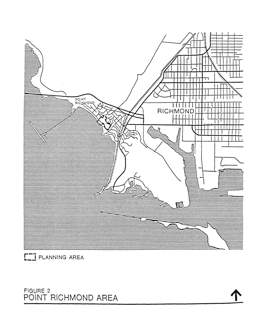
4 List of Figures 1. Regional Location 2. Point Richmond Area 3. Planning Area 4. Study Area Vicinity
5
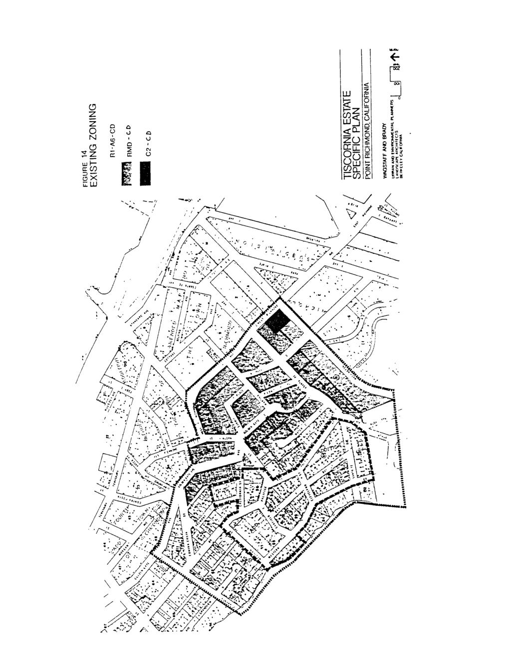
6 Table I SUMMARY DATA PLANNING AREA LOCATION PLANNING AREA SIZE PARCELIZATION

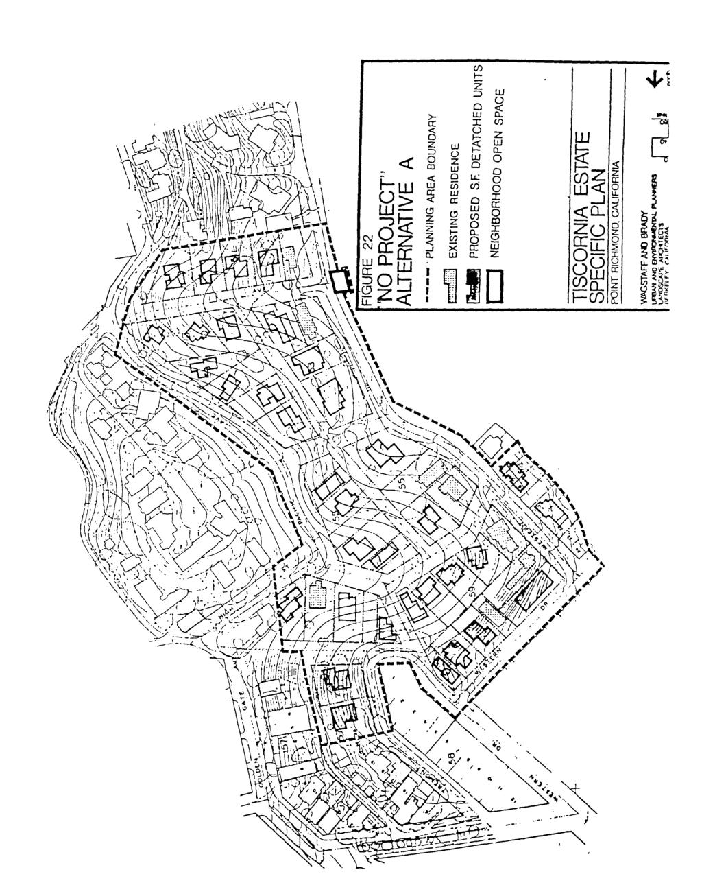
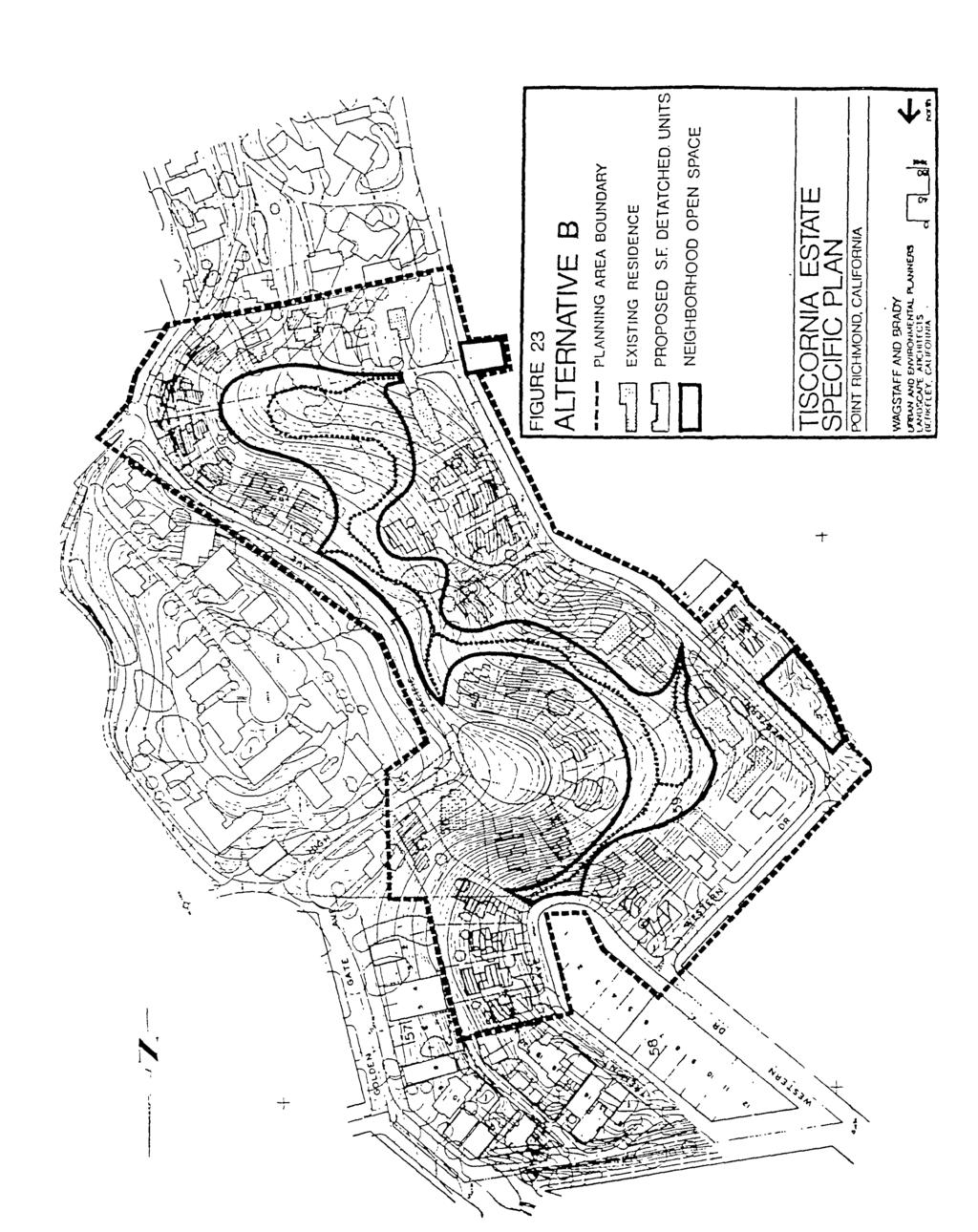
7 open space area will consist of the upper elevations of the planning area including the prominent central knoll west
8
9 II. INTRODUCTION A. PLAN PURPOSE This document constitutes a specific plan and master environmental assessment for the future
10 tion 6540.
11 Fearing again that the property might be developed piecemeal by Shean, the Point Richmond neighborhood residents submitted
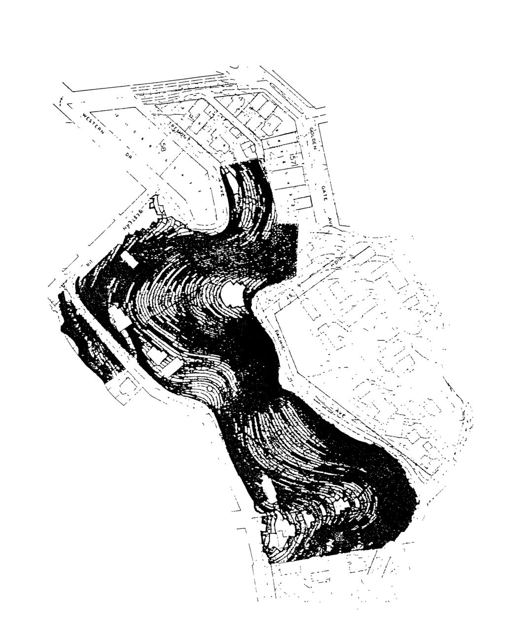
12
13 III. PLANNING AREA A. REGIONAL LOCATION As illustrated
14
15
16
17
18
19 fig 5, aerial photograph, fanfold front
20
21 tion,
22
23
24 Table 2 PLANNING AREA OWNERSHIP AND PARCELIZATION Owner Block 1.
25 Table 2, continued PLANNING AREA OWNERSHIP
26 Table
27 IV. PLAN GOALS The list
28 9. Link recreational opportunities within the planning area to offsite local and regional facilities through appropriate alignment of trail systems and access points. Provide
29 7. Design development on slopes above 15 percent with special attention to controlling erosion
30 8. The plan should be easily implemented by the city planning staff with reasonable administrative review requirements.
31 V. LAND
32
33

34 A minimum of two offstreet parking spaces per dwelling unit is required of the plan. Spaces will
35 family residential development proposed for the planning area should not be of any one particular style
36 (1) Front Yards: Front yard setbacks shall be no less than twenty (20) percent of the depth
37 (3) A detailed soil and geologic investigation of all sites will be required prior to approval
38
39
40 FIGURE 10 BUILDING DESIGN GUIDELINES
41 (1) Each dwelling unit will be required to have two permanently maintained offstreet parking spaces. Each parking space shall not be less than ten (10) feet wide by twenty (20) feet long. (2) Other requirements for parking spaces (i.e., location, covering, etc.) will be
42

43 prior to approval of use permits. The character and basic elements that should be incorporated into the design of the open space system are described below. a. Area East of Western Drive. This open space area consists primarily of the planning area's steep upper slopes, including
44 (1)
45 (c) The close proximity of private residences is both a reason for limiting access to the area (due to potential noise conflicts, etc.) and a natural deterrent
46
47 VI. CIRCULATION ELEMENT This section of the plan identifies a specific set of circulation policies that will be adequate to accommodate the growth proposed by the plan while maintaining the character of the existing circulation system. These policies include roadway standards for planning area roadways, related road improvement standards for the planning area, descriptions of offsite roadway improvements necessary to accommodate planning area buildout, suggested construction sequences, estimated costs,
48
49 B. INTERNAL ROADWAY IMPROVEMENTS Figure 11 diagrams the recommended road system to serve planning area needs at full buildout. Five general improvements or alterations to the planning area road system
50 widened
51 5. Onstreet Parking The narrow width of existing streets does not facilitate safe, onstreet parking. In order
52 D. CIRCULATION ELEMENT POLICIES 1. Development approvals shall be conditional on applicant provision of the roadway needs

53 VII. PUBLIC FACILITIES ELEMENT
54
.")
55 The District currently provides water within the planning area from 6-inch water mains located in Western Drive, Tremont Avenue, and Santa Fe Avenue (see Figure 13 for location). These mains are still in good condition and are adequately sized
56

57 C. STORM DRAINAGE 1. Existing Planning Area Drainage There are three (3) major drainage swales that carry planning area runoff. In addition to planning area runoff, the swales in the center and southern end of the planning area carry runoff from the slopes above the planning area by these culverts under Pacific
58 natural or rural character of the neighborhood and should not degrade the visual character
59 The closure of Pacific Avenue to all but emergency vehicles will ensure fire access along this street without conflict from other traffic
60 request that the city approve the neighborhood for the undergrounding of utilities. PG&E allocates limited funds annually to each jurisdiction within their service area for undergrounding. Jurisdictions must supplement these funds to cover undergrounding costs. PG&E
61 VIII. FINANCING AND IMPLEMENTATION ELEMENT The policies and guidelines of this specific plan are intended to provide for orderly development in the planning area. This section of the plan makes recommendations regarding the administrative, financing, development review, and regulatory approaches that should be followed to effectively implement this specific plan.
62
63 Table 4 ON- AND OFFSITE CAPITAL IMPROVEMENTS REQUIRED BY THE SPECIFIC PLAN Type of Improvement Streets and Parking Improvements That Benefit All Property Owners Installation Water Distribution System Sewage Collection System Storm Drainage System Utility Undergrounding
64 fits
65 responsibility of the owner(s) of those parcels located along Pacific and Bishop avenues.
66 and Casey Drive will
67
68 Table 5 ESTIMATED COST RESPONSIBILITIES FOR CAPITAL IMPROVEMENTS Improvement Road System 1 Extension

69 IX. SPECIFIC PLAN RELATIONSHIPS TO LOCAL GENERAL PLAN GOALS AND POLICIES The planning area
70 "5. Provide for the recreational and cultural needs of the community with a variety of opportunities for leisure time activity available in each neighborhood and in the community in Conformance with standards established by the Recreation Commission
71 "a. Single-family detached units, townhouses, and garden court apartments; terraced apartments that follow steep hillside contours;
72 The Richmond Coastline Plan,
73
74
75
76 Area Additive District is combined with the R-1 (or other basic) district, the lot area, front
77 within

78 Service actively discourages activities
79 Plan design guidelines recommend that concrete grout capping
80
81 X. ENVIRONMENTAL IMPACTS A. INTRODUCTION The following section provides a documentation of environmental impacts, assuming full realization of land use and circulation policies recommended in the specific plan. This environmental impact component
82 250 units. The Brickyard Landing residential 310-unit condominium development now under construction
83 provided at this location, and the steep bluff that separates the houses from the shoreline acts as a natural deterrent to potential trespassers. 3. Mitigation Measures
84 FIGURE
85
86 along
87 rounding roadways. Assuming that each single-family residential unit would gener-
88 FIGURE
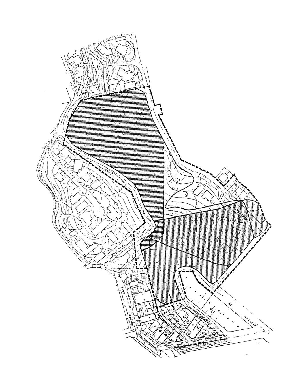
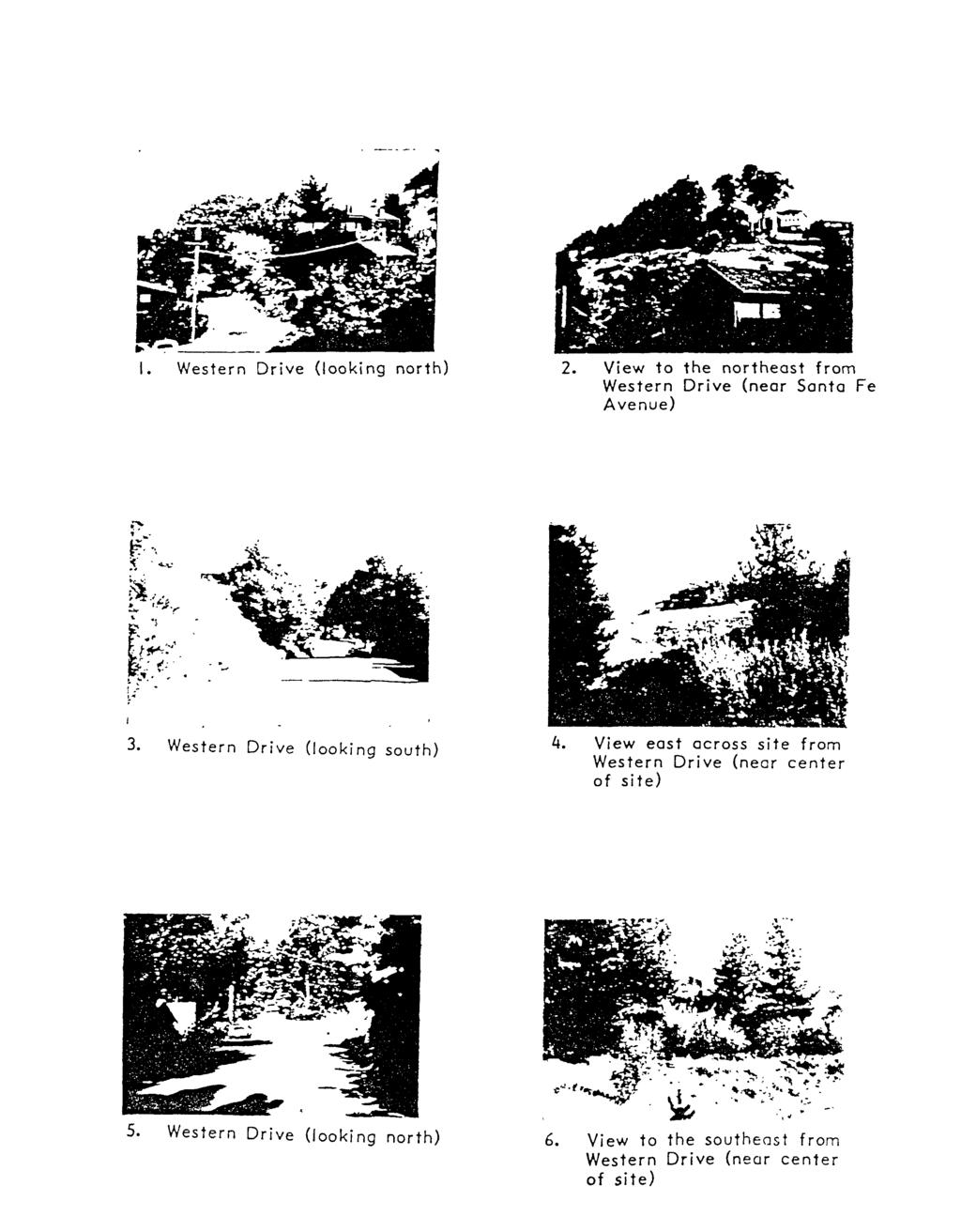
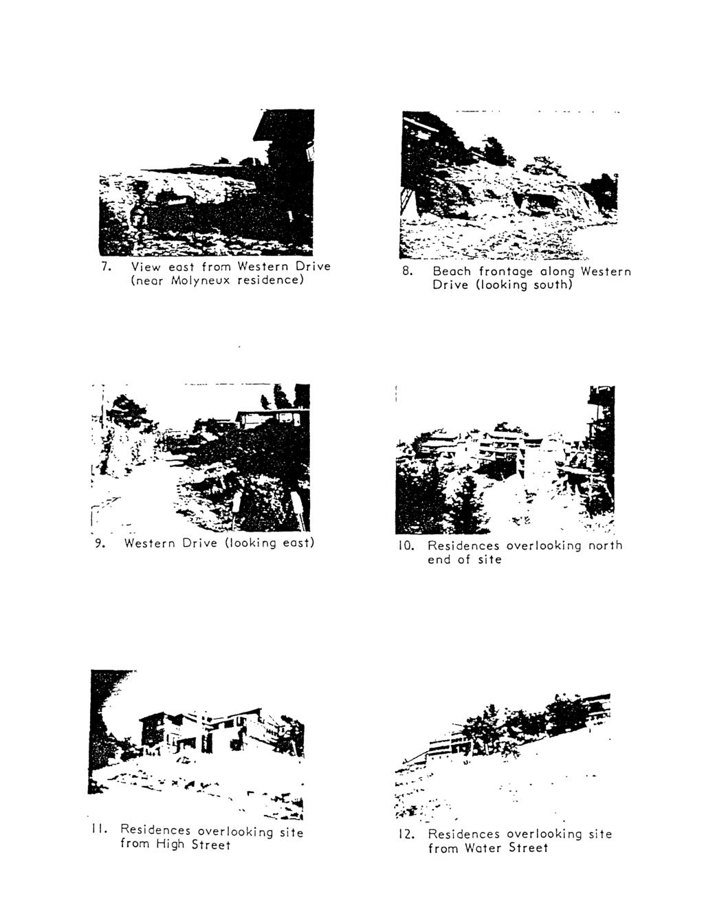
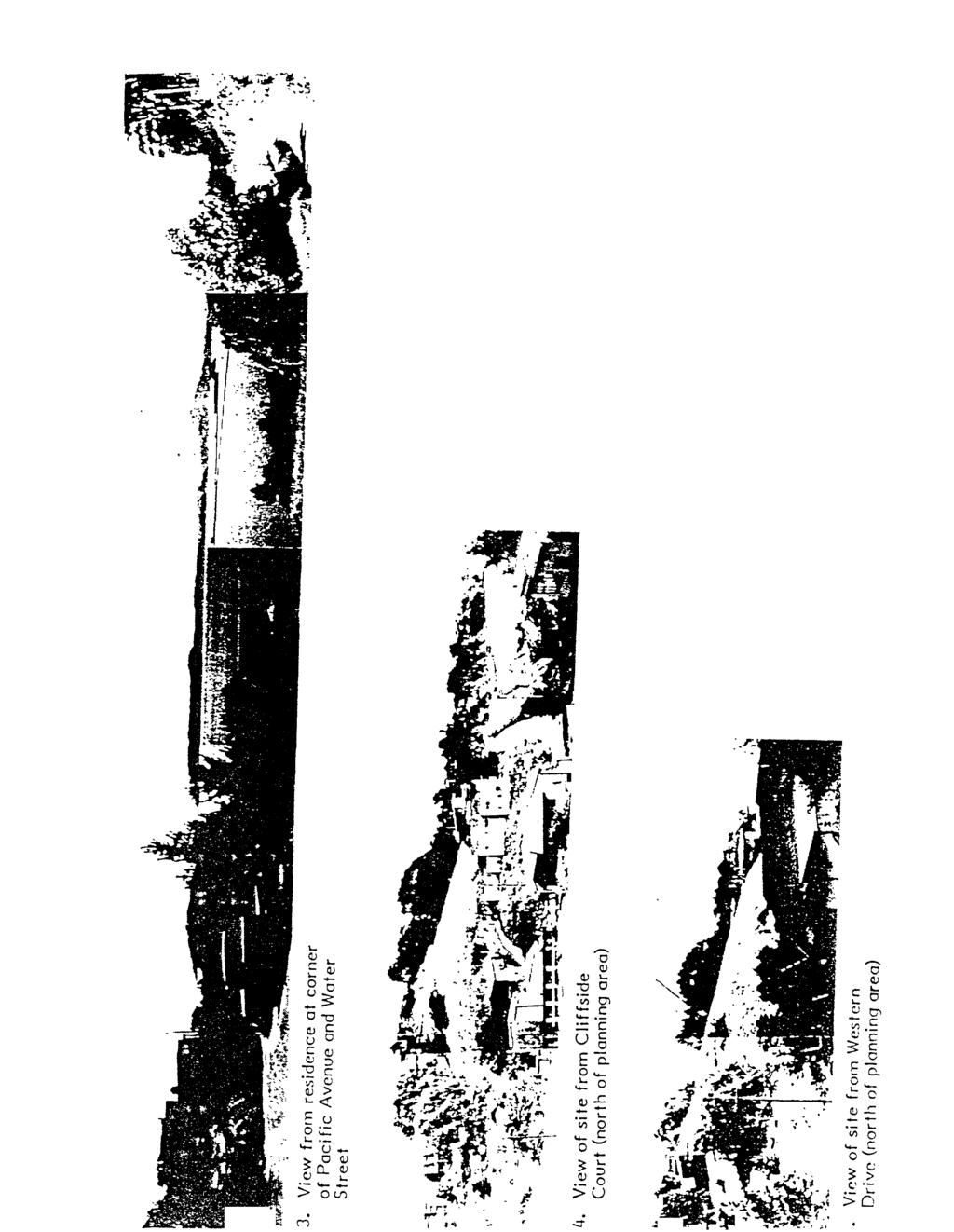
89 be on fire protection services. Fire Department vehicles would be able to easily reach all units; however, all of the longer vehicles would be required to back down the culs-de-sac
90 opment have not been incorporated in the plan because of the desire of local residents to maintain the area's existing rural character. The plan does recommend a number

91 ning area developers. Estimates of these costs are included in the Financing and Implementation Element (Section VIII) of this plan. Ongoing costs associated with sewer service would
92
93 who will
94 (1)
95 " In order to preserve visual access to the Bay and the regional landscape, urge that new residential developments on sloping or waterfront sites be grouped or clustered... " Urge that new residential, commercial and industrial development in the Coastline Area attempt
96
97 FIGURE 18 VIEWS OF PLANNING AREA FROM SURROUNDING AREAS

98 The portion

99 Bay. Where the planning area extends across Western Drive to the shoreline, the absence of development permits focused views out to the Bay.
100
101 FIGURE
102
103
104
105

106
107 a. Effect on Views of Planning Area from Surrounding Points (1) Areas North of the Site. The plan calls for development on the lower slopes adjacent to Western Drive and Tremont Avenue. This will increase density of development and remove some open space areas that now exist but would have little significant visual impact. The grassy knoll and eucalyptus grove, which are the most prominent visual elements
108 view, because vehicular access (except

109 a. Historic Resources. A review of the historic documentation for the Point Richmond region indicates that
110 The development plans
111 The planning area topography consists
112
113 FIGURE
114
115 FIGURE 21 GEOLOGY
116
117
, coyote brush (Baccharis pilularis), and poison oak (Rhus diversiloba).")
118 Scotch broom (Cytisus scoparius) covers large areas of the site, especially within and surrounding the drainage swales. Other shrub species include toyon (Heteromeles arbutifolia), coyote brush (Baccharis pilularis), and poison oak (Rhus diversiloba). The rest of the site is covered with grassland species common to disturbed areas. Species noted during site surveys were vetch, lupine, chickweed, sourgrass, mullein, convolvulus, California poppy, wild radish, fennel, and several species of grass. Ice plant (Carpobrotus spp.)
119

120 Major open space areas
121 FIGURE
122 cels under
123
124

125 of design standards and development guidelines would lead to significant impacts on views into

126 these areas long-range views would
127
128 facilitate additional development on isolated lots in the surrounding area, but would not create any development potential that does not already exist. The improvements proposed
129 Ray Ostrander, Facility Engineer, Pacific Bell Bill McGowan, Associate Civil Engineer, East
130
131 APPENDIX A. LEVEL OF SERVICE AND CAPACITY DEFINITIONS ROADWAY
132
133 APPENDIX
City Center Specific Plan Amendments And Background Report City of Richmond. PLANNING COMMISION FINAL DRAFT January, 2001
 City Center Specific Plan Amendments And Background Report City of Richmond PLANNING COMMISION FINAL DRAFT January, 2001 TABLE OF CONTENTS Page LIST OF TABLES... LIST OF FIGURES... INDEX... OVERVIEW...
ARTICLE IV: DEVELOPMENT STANDARDS 404 MASTER PLANNING
 IV 13 404 MASTER PLANNING Master Planning through the Site Analysis (Master Planning Site Analysis) or Planned Development (Master Planning Planned Development) is provided to encourage development which
Urban Planning and Land Use
 Urban Planning and Land Use 701 North 7 th Street, Room 423 Phone: (913) 573-5750 Kansas City, Kansas 66101 Fax: (913) 573-5796 Email: planninginfo@wycokck.org www.wycokck.org/planning To: From: City Planning
City of Lafayette Study Session Staff Report Design Review Commission
 ++ City of Lafayette Study Session Staff Report Design Review Commission Meeting Date: January 08, 2018 Staff: Subject: Chris Juram, Planning Technician SS12-17 Miramar Homebuilders, R-20 Zoning: Request
3.10 LAND USE SETTING PROJECT SITE EXISTING LAND USE DESIGNATIONS AND ZONING. General Plan Land Use Designations.
 This section of the Draft EIR addresses the existing land uses on and adjacent to the project site and discusses the potential impacts of the proposed project on existing land uses. Key issues addressed
Holmberg & Howe, Land Surveyors and Civil Engineers Zoning District: R-35
 Development Impact Statement Name of Project: Red Tail Drive Acreage: 13.5 Acres± Type of Project: Residential Subdivision Owner: 96 East Street Development, LLC Location: rear of 112 East Street Parcel
Ten Mile Creek Planning Area
 PLANNING AREA POLICIES TEN MILE CREEK Ten Mile Creek Planning Area Location and Context The Ten Mile Creek Planning Area ( Ten Mile Creek area ) is located south of the current Boise AOCI, generally south
IV.B. VISUAL RESOURCES
 IV.B. VISUAL RESOURCES ENVIRONMENTAL SETTING Existing Visual Character Project Site The project site is located at 17331-17333 Tramonto Drive in the Pacific Palisades community of the City of Los Angeles
Covenant Design Review Committee Supplemental Design Criteria
 Covenant Design Review Committee Supplemental Design Criteria FENCESandWALLS ne of the defining characteristics of Rancho Santa Fe is the open character of its landscape. The Ranch s unique appearance
City of Lafayette Staff Report
 City of Lafayette Staff Report For: By: Design Review Commission Greg Wolff, Senior Planner Meeting Date: April 27, 2015 Subject: SS03-15 Gundi & Peter Younger (Owners), R-40 Zoning: Request for a Study
Institutional Master Plan The Arnold Arboretum of Harvard University
 Institutional Master Plan The Arnold Arboretum of Harvard University Submitted to: Boston Redevelopment Authority One City Hall Square Boston, MA 02201 Submitted by: The Arnold Arboretum of Harvard University
AWH REPORT OF THE PLANNING AND DEVELOPMENT DEPARTMENT FOR APPLICATION FOR REZONING ORDINANCE TO PLANNED UNIT DEVELOPMENT
 AWH REPORT OF THE PLANNING AND DEVELOPMENT DEPARTMENT FOR APPLICATION FOR REZONING ORDINANCE TO PLANNED UNIT DEVELOPMENT MAY 8, 2014 The Planning and Development Department hereby forwards to the Planning
OP Council Resolution June 16, Planning and Development Services
 OP-08-01 Council Resolution June 16, 2008 Planning and Development Services Kingsgate Landing Outline Plan Table of Contents 1.0 Introduction 1 1.1 Purpose of Plan 1 1.2 Plan Area Location 1 1.3 Ownership
Master Plan Objectives and Policies
 Master Plan Objectives and Policies Introduction This chapter identifies the Park issues and recommended policies established by this Master Plan. The issues were identified through meetings with staff,
MASTER PLAN. 201 Planning Concepts. Chapter 2
 Chapter 2 MASTER PLAN 201 Planning Concepts 202 Master Land Use Plan 203 Affordable Housing Program 204 Parks, Open Space, and Recreation Trails 205 Grading Concept 206 Circulation Plan 207 Landscape Concept
Cumberland Comprehensive Plan Town Council adopted August 2003, State adopted June 2004 TABLE OF CONTENTS
 TABLE OF CONTENTS I. Executive Summary A. Scope of the Comprehensive Plan I-2 B. Plan Development Process I-3 C. Plan Format I-3 D. Acknowledgements I-4 II. Demographic Analysis A. Introduction II-1 B.
UNIVERSITY OF MICHIGAN:
 Chapter Eight UNIVERSITY OF MICHIGAN: North Campus I. Introduction The University of Michigan currently owns approximately 800 acres of land in the northeast section of Ann Arbor. North Campus refers to
I539. Smales 2 Precinct
 I539. Smales 2 Precinct I539.1. Precinct Description The Smales 2 Precinct applies to a 4.8 hectare block of land located on the southern side of Northcote Road and fronting Lake Pupuke, Takapuna. The
PLANNED UNIT DEVELOPMENT & SUBDIVISION STAFF REPORT Date: May 18, 2017
 & PUD-0000102-2017 PLANNED UNIT DEVELOPMENT & SUBDIVISION STAFF REPORT Date: May 18, 2017 NAME SUBDIVISION NAME Dauphin Creek Estates Subdivision Dauphin Creek Estates Subdivision LOCATION CITY COUNCIL
Urban Fringe Subarea Plan
 Urban Fringe Subarea Plan Updated February 27, 2018 Table of Contents Page I. Existing Goals and Policy Framework 2 A. Growth Management Act (GMA) B. County-wide Planning Policies C. Whatcom County Comprehensive
Asbury Chapel Subdivision Sketch Plan
 Asbury Chapel Subdivision Sketch Plan PART 1: PROJECT SUMMARY Applicant: NVR Inc. Project Size: +/- 76.13 acres Parcel Numbers: 02101112,02116101,02116112, 02116113 Current Zoning: Transitional Residential
NOTICE OF PREPARATION OF A DRAFT ENVIRONMENTAL IMPACT REPORT
 NOTICE OF PREPARATION OF A DRAFT ENVIRONMENTAL IMPACT REPORT TO: SUBJECT: Interested Parties Notice of Preparation of a Draft Environmental Impact Report for the Marywood Residential Development project.
Infill Residential Design Guidelines
 Infill Residential Design Guidelines Adopted March 23, 2004 Amended September 10, 2013 City of Orange Community Development Department Planning Division Phone: (714) 744-7220 Fax: (714) 744-7222 www.cityoforange.org
CHECKLIST FOR PHASE II DRAINAGE REPORT
 I. COVER SHEET CHECKLIST FOR PHASE II DRAINAGE REPORT A. Name of Project B. Address C. Owner D. Developer E. Engineer F. Submittal date and revision dates as applicable II. GENERAL LOCATION AND DESCRIPTION
SECTION II SECTION II STATEMENT OF GOALS, OBJECTIVES, PRINCIPLES, ASSUMPTIONS, POLICIES AND STANDARDS
 STATEMENT OF GOALS, OBJECTIVES, PRINCIPLES, ASSUMPTIONS, POLICIES AND STANDARDS 1 2 STATEMENT OF GOALS, OBJECTIVES, PRINCIPLES, ASSUMPTIONS, POLICIES AND STANDARDS INTRODUCTION The New Jersey Municipal
SECTION 1 CLEARING /GRADING PERMIT APPLICATION:
 PLEASE REFER TO THE CLEARING & GRADING PERMIT CHECKLIST BELOW FOR SUBMITTAL REQUIREMENTS. SECTION 1 CLEARING /GRADING PERMIT APPLICATION: PROJECT ADDRESS (Street, Suite #): Parcel(s) #: Total Site Area
SPECIFIC PLAN Requirements
 CITY OF LANCASTER PLANNING DEPARTMENT 44933 Fern Avenue, Lancaster, California 93534 (661) 723-6100 SPECIFIC PLAN Requirements Purpose The purpose of a specific plan is to provide for the logical development
OFFICE CONSOLIDATION SECONDARY PLAN AREA 22 THE BRAMALEA SOUTH INDUSTRIAL SECONDARY PLAN
 OFFICE CONSOLIDATION SECONDARY PLAN AREA 22 THE BRAMALEA SOUTH INDUSTRIAL SECONDARY PLAN November 2010 EXPLANATORY NOTES (Secondary Plan Area 22) General (pertaining to all secondary plan office consolidations)
STORMWATER MANAGEMENT CODES ANALYSIS RICHLAND COUNTY, SC SITE PLANNING ROUNDTABLE
 STORMWATER MANAGEMENT CODES ANALYSIS RICHLAND COUNTY, SC SITE PLANNING ROUNDTABLE Codes analyses for each subcommittee were completed to assist participants of the Richland County Site Planning Roundtable.
ROAD CLOSURE AND LAND USE AMENDMENT SILVER SPRINGS (WARD 1) NORTHEAST OF NOSEHILL DRIVE NW AND SILVER SPRINGS ROAD NW BYLAWS 2C2018 AND 29D2018
 NORTHEAST OF NOSEHILL DRIVE NW AND SILVER SPRINGS ROAD NW BYLAWS 2C2018 AND 29D2018") Page 1 of 19 EXECUTIVE SUMMARY This application proposes redesignating two parcels in the community of Silver Springs from Special Purpose Future Urban Development (S-FUD) District and undesignated road
Page 1 of 19 EXECUTIVE SUMMARY This application proposes redesignating two parcels in the community of Silver Springs from Special Purpose Future Urban Development (S-FUD) District and undesignated road
Urban Design Brief December 23, 2015 Southside Construction Group Official Plan & Zoning By-Law Amendment
 Urban Design Brief Proposed Official Plan & Zoning By-Law Amendment 3244, 3263 and 3274 Wonderland Road South Southside Group December 23, 2015 TABLE OF CONTENTS Page No. INTRODUCTION... 1 SECTION 1 LAND
City of Lafayette Study Session Staff Report Design Review Commission
 City of Lafayette Study Session Staff Report Design Review Commission Meeting Date: April 24, 2017 Staff: Payal Bhagat, Senior Planner Subject: HDP18-15 & HDP31-15 Ramesh Patel & Melcor Development (Owners),
1.0 Circulation Element
 5/9/18 1.0 Circulation Element 1.1 Introduction As growth and development occur in Apache County, enhancements to its circulation system will be necessary. With time, more roads will be paved and air and
9 th Street Sub Area Plan
 9 th Street Sub Area Plan In the 1990 s, when the Township prepared the last Master Plan, the 9 th Street corridor was studied as part of a larger 9 th Street Focus Area that included the West Main Street
Project: Developer/Designer: Reviewer: I. Narrative: 1. Project Description: Describes the nature and purpose of the land disturbing activity.
 City of Charlottesville, Virginia Erosion and Sediment Control Plan Review Checklist 610 East Market Street, Charlottesville, VA 22902 Telephone 434-970-3182; Fax 434-970-3359 Project: Developer/Designer:
GENERAL PLAN CONSISTENCY ANALYSIS
 GENERAL PLAN CONSISTENCY ANALYSIS Prepared by Planning Staff 10/28/2013 APPLICABLE GOALS, POLICIES AND PROGRAMS FROM the LAND USE CHAPTER Goal LU-1 Policy LU-1.1 Policy LU-1.2 Goal LU-2 Protect the character
Existing Conditions Summary (Draft for Review)
") Existing Conditions Summary (Draft for Review) Prepared by March 16, 2015 Bird s-eye-view of Norwalk in 1899 (Cropped) Existing Conditions Summary (Draft for Review) March 16, 2015 Table of Contents 1.
Existing Conditions Summary (Draft for Review) Prepared by March 16, 2015 Bird s-eye-view of Norwalk in 1899 (Cropped) Existing Conditions Summary (Draft for Review) March 16, 2015 Table of Contents 1.
INTRODUCTION. 1.1 What is a General Plan? 1.2 Requirements for a General Plan. 1.3 Introduction to Monterey County
 1.1 What is a General Plan? INTRODUCTION California state law requires each city and county to adopt a comprehensive, long-term general plan for the physical development of the county or city, and any
SITE PLAN REVIEW APPLICATION AND CHECKLIST
 SITE PLAN REVIEW APPLICATION AND CHECKLIST PROJECT SUMMARY: Project Name: City/ETA Location: City ETA (Application fee & number of copies needed are based on location) Property Location (Legal Description
COLVER ROAD INDUSTRIAL CONCEPT PLAN
 COLVER ROAD INDUSTRIAL CONCEPT PLAN A CONCEPTUAL LAND USE AND TRANSPORTATION PLAN FOR TA-4 AN URBAN RESERVE AREA OF THE CITY TALENT City of Talent Adopted by City Council Resolution No., June, 2015 PART
HALF MOON BAY LOCAL COASTAL PROGRAM. d), JOHN M. St>NGER ASSOCIATES INC S.F.' CA EIOO VISUAL RESOURCES OVERLAY.
, JOHN M. St>NGER ASSOCIATES INC S.F.' CA EIOO VISUAL RESOURCES OVERLAY.") VISUAL RESOURCES OVERLAY Old Downtown Jl&& Scenic Hillsides Ocean Views from Highway 1 HALF MOON BAY LOCAL COASTAL PROGRAM d), JOHN M. St>NGER ASSOCIATES INC S.F.' CA. 94114 EIOO 217 CHAPTER 7: VISUAL
VISUAL RESOURCES OVERLAY Old Downtown Jl&& Scenic Hillsides Ocean Views from Highway 1 HALF MOON BAY LOCAL COASTAL PROGRAM d), JOHN M. St>NGER ASSOCIATES INC S.F.' CA. 94114 EIOO 217 CHAPTER 7: VISUAL
PLANNING COMMISSION. Submitted
 PLANNING COMMISSION City Hall 1275 Main Street El Centro, CA 92243 Submitted PLANNING COMMISSION ACTION ITEM (1844) Meeting: 05/10/16 12:00 AM Department: Community Development Category: Public Hearing
CITY OF CYPRESS 5275 Orange Avenue Cypress, California (714) DESIGN REVIEW COMMITTEE PERMIT PROCESS
 DESIGN REVIEW COMMITTEE PERMIT PROCESS") CITY OF CYPRESS 5275 Orange Avenue Cypress, California 90630 (714) 229-6720 DESIGN REVIEW COMMITTEE PERMIT PROCESS 1. Discuss project with Planning staff to determine zoning regulations, any unusual characteristics
CITY OF CYPRESS 5275 Orange Avenue Cypress, California 90630 (714) 229-6720 DESIGN REVIEW COMMITTEE PERMIT PROCESS 1. Discuss project with Planning staff to determine zoning regulations, any unusual characteristics
CHAPTER 22 Rural Open Space Community Developments
 CHAPTER 22 Rural Open Space Community Developments Section 22.1 Description and Purpose The intent of this Chapter is to offer property owners an alternative to traditional zoning requirements for rural
APPENDIX C: STORMWATER CONTROL PLAN
 APPENDIX C: STORMWATER CONTROL PLAN STORM WATER MANAGEMENT PLAN FOR PLEASANT HILL, CALIFORNIA Prepared for Compliance with the Clean Water Program (C.3) and the San Francisco Bay Regional Water Quality
APPENDIX A SIMPLIFIED APPROACH TO STORMWATER MANAGEMENT FOR SMALL PROJECTS. In West Sadsbury Township, Chester County, Pennsylvania
 APPENDIX A SIMPLIFIED APPROACH TO STORMWATER MANAGEMENT FOR SMALL PROJECTS In West Sadsbury Township, Chester County, Pennsylvania TABLE OF CONTENTS I. Introduction 3 II. Importance of Stormwater Management
City of Richmond. Engineering Design Specifications
 City of Richmond Design Specifications June 2008 CITY OF RICHMOND ENGINEERING DESIGN SPECIFICATIONS JUNE 2008 THIS DOCUMENT DETAILS THE MINIMUM STANDARDS TO BE USED FOR THE DESIGN OF ENGINEERING PROJECTS
STAFF REPORT FOR STANDARD COASTAL DEVELOPMENT PERMIT #CDP FEBRUARY 26, 2015 CPA - 1 PO BOX 238 APTOS, CA 94001
 STAFF REPORT FOR STANDARD COASTAL DEVELOPMENT PERMIT #CDP 2014-0030 FEBRUARY 26, 2015 CPA - 1 OWNER/APPLICANT: AGENT: REQUEST: HANS HEIM PO BOX 238 APTOS, CA 94001 JAMES HAY PO BOX 762 MENDOCINO, CA 95460
Venice Pumping Plant Dual Force Main Project Draft EIR
 City of Los Angeles 5.9 LAND USE PLANS 5.9.1 Environmental Setting Venice Pumping Plant Dual Force Main Project Draft EIR The Project lies within the bounds of Los Angeles County and the City of Los Angeles.
ENVIRONMENTAL IMPACT REPORT COMPREHENSIVE GENERAL PLAN AND ZONING ORDINANCE SCH NUMBER:
 ENVIRONMENTAL IMPACT REPORT FOR THE CITY OF BANNING COMPREHENSIVE GENERAL PLAN AND ZONING ORDINANCE SCH NUMBER: 2005011039 Prepared for: City of Banning 99 East Ramsey Street Banning, CA 92220 Prepared
ARTICLE 3 LANDSCAPING AND SCREENING REQUIREMENTS
 ARTICLE 3 CHAPTER 4 LANDSCAPING AND SCREENING REQUIREMENTS SEC 3.401 SEC 3.402 (D) (E) PURPOSE: The purpose of this Chapter is to establish minimum standards for the design, installation, and maintenance
COMPLIANCE CHECKLIST HILLSIDE RESIDENTIAL DESIGN GUIDELINES MANUAL
 COMPLIANCE CHECKLIST HILLSIDE RESIDENTIAL DESIGN GUIDELINES MANUAL The following checklist summarizes development guidelines and standards. See the appropriate section for a complete explanation of the
Chapter 4 - Preparation of Stormwater Site Plans
 Chapter 4 - Preparation of Stormwater Site Plans The Stormwater Site Plan is the comprehensive report containing all of the technical information and analysis necessary for the City to evaluate a proposed
General Location Annex, Rezone & Preliminary Plat Lansdowne Addition, Unit Three
 NEWFOUNDLAND I-5 Agricultural District Subject Site SUNDANCE ANDERSON Single Family Residential CHRISTY PUD Agricultural District Highway Business General Location Annex, Rezone & Preliminary Plat Lansdowne
Draft Rhode Island Stormwater Design and Installation Standards Manual
 Draft Rhode Island Stormwater Design and Installation Standards Manual Summary The May 2009 Public Review Draft version of the RI Stormwater Design and Installation Standards Manual consists of approximately
Description of Preferred Alternative
 Chapter 2 Description of Preferred Alternative 2.1 Introduction This chapter of the programmatic Sammamish Town Center Sub-area Plan Final EIS provides a more detailed description of the Preferred Alternative
SECTION 7A: WHAKARONGO RESIDENTIAL AREA
 SECTION 7A: WHAKARONGO RESIDENTIAL AREA CONTENTS 7A.1 Introduction 1 7A.2 Resource Management Issues 1 7A.3 Objectives and Policies 1 7A.4 Methods 4 7A.5 Residential Zone 4 7A.5.1 Rules: Controlled Activities
Article 10: Landscaping and Buffering
 10.01: Purpose Article 10: Landscaping 10.01: Purpose The purpose of this article is to: A) Promote and protect the interest of the public convenience, comfort, prosperity, or general welfare in accordance
PART 1: PROJECT SUMMARY. The application is Attachment A. The site plan is Attachment B.
 Belleterre Subdivision Sketch Plan Town Board 8.7.17 Belleterre Subdivision Sketch Plan PART 1: PROJECT SUMMARY Applicant: Bowman Development Project Size: +/- 20.85 acres Parcel Number: 01115104 and 01115121
6 PORT SYDNEY SETTLEMENT AREA
 Section 6 Port Sydney Page 61 6 PORT SYDNEY SETTLEMENT AREA 6.1 Basis and Principles Village of Port Sydney Waterfront Community Existing Services 6.1.1 Port Sydney is an historic settlement that has developed
F. The following uses in the HR District: attached single-family dwellings, condominiums, and institutional uses; and
 1102 DESIGN REVIEW 1102.01 PURPOSE AND APPLICABILITY Section 1102 is adopted to provide standards, criteria, and procedures under which design review may be approved. Design review is required for: A.
Table of Contents TABLE OF CONTENTS SECTION TITLE PAGE
 TABLE OF CONTENTS SECTION TITLE PAGE 1 INTRODUCTION AND OVERVIEW 1-1 1.1 Purpose and Need 1-1 1.2 Goals and Objectives 1-3 1.3 Overview of the Planning Process 1-5 1.4 Federal and State Requirements and
COMMUNITY DEVELOPMENT SERVICES PLANNING AND BUILDING DEPARTMENT PLACERVILLE OFFICE:
 COMMUNITY DEVELOPMENT SERVICES PLANNING AND BUILDING DEPARTMENT http://www.edcgov.us/devservices/ PLACERVILLE OFFICE: LAKE TAHOE OFFICE: 2850 Fair Lane Court, Placerville, CA 95667 924 B Emerald Bay Rd.
Springbrook Oaks Specific Plan. August 2, City of Newberg P.O. Box 970 Newberg, OR (503)
") Springbrook Oaks Specific Plan August 2, 1999 ity of Newberg P.O. Box 970 Newberg, OR 97132 (503) 537-1240 Springbrook Oaks Specific Plan - Final - Adopted August 2, 1999 Page 1 THE SPRINGBROOK OAKS SPEIFI
Springbrook Oaks Specific Plan August 2, 1999 ity of Newberg P.O. Box 970 Newberg, OR 97132 (503) 537-1240 Springbrook Oaks Specific Plan - Final - Adopted August 2, 1999 Page 1 THE SPRINGBROOK OAKS SPEIFI
Notice of Preparation of an Environmental Impact Report and Scoping Meeting for the Canyon Lane Roadway Improvements Development Project
 of an Environmental Impact Report and Scoping Meeting for the As the Lead Agency, the County of San Mateo (County) will prepare an Environmental Impact Report (EIR) for the (project), and would like your
Example Codes. City of Brentwood, Tennessee Brentwood Hillside Protection Overlay District Summary
 Example Codes City of Brentwood, Tennessee Brentwood Hillside Protection Overlay District Summary The City of Brentwood in July 2007 adopted a Hillside Protection (HP) Overlay District to address the problems
PRELIMINARY PLAT DESIGN REQUIREMENTS Updated 4/8/2016
 PRELIMINARY PLAT DESIGN REQUIREMENTS Updated 4/8/2016 The following items are required for the preliminary plat. Numbers correspond with those on the example preliminary plat. RENO COUNTY SUBDIVISION REQUIREMENTS
Urban Design Brief 1576 Richmond Street City of London
 Urban Design Brief City of London Treadstone Developments October 31, 2014 Urban Design Brief October 31, 2014 TABLE OF CONTENTS Page No. INTRODUCTION... 1 SECTION 1 LAND USE PLANNING CONCEPT... 1 1.1
City of Grande Prairie Development Services Department KENNEDY DEVELOPMENTS LTD. OUTLINE PLAN OP-09-01
 City of Grande Prairie Development Services Department KENNEDY DEVELOPMENTS LTD. OUTLINE PLAN OP-09-01 July 27, 2009 TABLE OF CONTENTS 1.0 Introduction... 1 1.1 Plan Area Location & Context... 1 1.2 Ownership
ORDINANCE NO WHEREAS, the City of Kalama has many areas of timberland and open areas inside its City limits adjacent to residential areas;
 ORDINANCE NO. 1342 AN ORDINANCE OF THE CITY OF KALAMA, WASHINGTON ADOPTING A NEW KALAMA MUNICIPAL CODE CHAPTER 17.20 ESTATE LOT FLOATING ZONE TO PROVIDE TRANSITIONAL ZONING OPTIONS FOR RESIDENTIAL DEVELOPMENT
Gruene River Place PDD CONCEPT PLAN AND DEVELOPMENT STANDARDS
 Gruene River Place PDD CONCEPT PLAN AND DEVELOPMENT STANDARDS GRUENE RIVER PLACE PLANNED DEVELOPMENT DISTRICT As per Section 3.5, Chapter 144 of the City s Zoning Ordinance To: The Planning & Zoning Commission
5.1 AESTHETICS AND VISUAL RESOURCES Physical Setting
 5.1 AESTHETICS AND VISUAL RESOURCES 5.1.1 Physical Setting Aesthetic values are an important aspect in establishing the identity, sense of place, and quality of life in a community. Natural features in
ENVIRONMENTAL INITIAL STUDY BERKELEY CITYWIDE POOLS MASTER PLAN
 ENVIRONMENTAL INITIAL STUDY FOR THE BERKELEY CITYWIDE POOLS MASTER PLAN CITY OF BERKELEY PARKS RECREATION AND WATERFRONT DEPARTMENT SEPTEMBER 1, 2009 ENVIRONMENTAL INITIAL STUDY BERKELEY CITYWIDE POOLS
Hidden Pointe Landscape Master Plan. June, archi terra
 Hidden Pointe Landscape Master Plan June, 2006 t h e archi terra g r o u p 1 Table of Contents Background Purpose and Goals of the Master Plan Master Plan Process Existing Conditions Entrance Hidden Pointe
DCA , Stormwater Quality and Facilities Ordinance June 23, 2009
 PROPOSED NEW SECTION 10.486 Stormwater Quality and Detention Facilities, Public Streets. A. Purpose. It is the City s policy to maintain the natural hydrology and preserve water quality by mitigating the
Beautification Advisory Committee Mission Statement and Goals & Objectives
 Beautification Advisory Committee Mission Statement and Goals & Objectives 2011-2012 MISSION STATEMENT To advise the Marco Island City Council on beautifying the community s landscape in a way consistent
IV. Development in the Rural Overlay District
 Intracoastal Waterway Route 17 Route 168 Great Dismal Swamp VIRGINIA NORTH CAROLINA IV. Development in the Rural Overlay District IV-1 Route 17 in Chesapeake s Rural Overlay District affords distant views
VISUAL QUALITY POLICIES
 VISUAL QUALITY POLICIES The County will: GOALS AND OBJECTIVES 4.1 Protection of Visual Quality a. Protect and enhance the natural visual quality of San Mateo County. b. Encourage positive visual quality
Advanced Site Inventory Activity
 9-12 ACTIVITY Advanced Site Inventory Activity 9-12 ACTIVITY Summary: Students investigate various elements of their Schoolyard Habitats site, including climate, land use, and human impact. Grade Level:
Non-Metallic Mining Reclamation Checklist
 Eau Claire County DEPARTMENT OF PLANNING AND DEVELOPMENT Eau Claire County Courthouse, Rm. 1510 721 Oxford Avenue Eau Claire, Wisconsin 54703-5481 (715) 839-4741 f Housing & Community Development 839-6240
PLANNED UNIT DEVELOPMENT PUD For The Proposed Antietam Subdivision Escambia County, Florida. Introduction
 PLANNED UNIT DEVELOPMENT PUD For The Proposed Antietam Subdivision Escambia County, Florida Introduction The project is located in Escambia County approximately 0.75 + miles north of the US Highway 90,
Non-Residential&Multi-Family PropertyCreditManual
 CityofRichmond DepartmentofPublicUtilities StormwaterManagementProgram Non-Residential&Multi-Family PropertyCreditManual ApprovedFebruary2011 City of Richmond Stormwater Non-Residential & Multi-Family
Coco Palms Community Development District. Engineer s Report Infrastructure Improvements
 Coco Palms Community Development District Engineer s Report Infrastructure Improvements Prepared for Coco Palms Community Development District Board of Supervisors Miami-Dade County, Florida Prepared by
NAPA COUNTY PUBLIC WORKS Standards & Specifications
 Roadway Design & Construction Manual (Table of Contents) 1. Chapter 1: General Provisions 1.1 Short Title 1.2 Jurisdiction 1.3 Purpose and Effect 1.4 Enactment Authority 1.5 Amendment and Revisions 1.6
TENTATIVE MAP CHECKLIST
 Business License 707.648.4357 www.cityofvallejo.net Central Permit Center 555 Santa Clara Street Vallejo CA 94590 Building 707.648.4374 Planning 707.648.4326 TENTATIVE MAP CHECKLIST Public Works/Engineering
APPLICATION FOR REZONING PROPERTY CITY OF HOLLAND, MICHIGAN. Name of Applicant. Address, and Phone # of Applicant
 APPLICATION FOR REZONING PROPERTY CITY OF HOLLAND, MICHIGAN Name of Applicant Address, Email and Phone # of Applicant Name and Address of Owner (if other than applicant) Ownership Interest of Applicant
VANDEN MEADOWS SPECIFIC PLAN TABLE OF CONTENTS Page 1.0 INTRODUCTION SUMMARY Schools Foxboro Parkway
 0 VANDEN MEADOWS SPECIFIC PLAN TABLE OF CONTENTS Page 1.0 INTRODUCTION 6 1.1. SUMMARY 6 1.1.1. Schools 11 1.1.2. Foxboro Parkway 11 1.1.3. Improvements to Leisure Town Road 11 1.1.4. New Neighborhood Park
SITE PLAN REVIEW ITEMS - REFERENCE CHECKLIST
 City of Seminole 9199 113 th Street N. Seminole, FL 33772 Ph: (727) 392-1966 Fx: (727) 319-6583 SITE PLAN REVIEW ITEMS - REFERENCE CHECKLIST Note: This checklist is designed to aid designers in the review
Bourne Downtown Site Planning
 Prepared for: The Town of Bourne, MA In Cooperation with: Bourne Financial Development Corporation Prepared by:, Inc. June 24, 2009 Table of Contents Introduction and Summary... 1 Site Existing Conditions...
Zoning Ordinance Chapter 10
 CHAPTER 10 - WASHES SECTION 10.0 GENERAL: A. The purpose of this Ordinance is to establish standards for development in or near Major and Minor Washes as defined in Appendix A Glossary of Terms and Definitions
RESIDENTIAL PLANNED UNIT DEVELOPMENT / SUBDIVISION AND REZONING CONCEPT AND DEVELOPMENT STAGE PLAN SUBMITTAL NARRATIVE
 RESIDENTIAL PLANNED UNIT DEVELOPMENT / SUBDIVISION AND REZONING CONCEPT AND DEVELOPMENT STAGE PLAN SUBMITTAL NARRATIVE DEVELOPMENT TEAM DONEGAL SOUTH Maple Grove, Minnesota March 27, 2017 Applicant/Developer/Builder:
Stafford County Strategic Plans
 Stafford County Strategic s Strategic Department Description Date Adopted Board of Supervisors Priorities Fiscal Responsibility Education Public Safety Infrastructure Economic Development Service Excellence
LONDONDERRY PLANNING BOARD SITE PLAN APPLICATION & CHECKLIST
 LONDONDERRY PLANNING BOARD SITE PLAN APPLICATION & CHECKLIST Planning Department Date Stamp Design Review Formal Application All information provided and submitted with this Application Checklist shall
East Panorama Ridge Concept Plan Amendment
 Page 1 of 7 L003 : East Panorama Ridge Concept Plan Amendment Corporate NO: L003 Report COUNCIL DATE: March 4, 2002 REGULAR COUNCIL LAND USE TO: Mayor & Council DATE: February 27, 2002 FROM: General Manager,
HAMLET OF KINGMAN AREA STRUCTURE PLAN
 HAMLET OF KINGMAN AREA STRUCTURE PLAN Prepared by: Austrom Consulting Ltd. Page 1 of 19 Table of Contents TABLE OF CONTENTS... 2 1. BACKGROUND... 3 1.1 PLAN AREA... 3 1.2 PLAN PURPOSE... 3 1.3 LEGISLATIVE
WATERS EDGE AT DOBBS FERRY DRAFT ENVIRONMENTAL IMPACT STATEMENT VOLUME I
 WATERS EDGE AT DOBBS FERRY DRAFT ENVIRONMENTAL IMPACT STATEMENT VOLUME I Atilda, Fairlawn and Constance Avenues Village of Dobbs Ferry Town of Greenburgh Westchester County, New York Tax Lot Numbers Section
The purpose of the requirements in this Article is to provide for landscaping and screening of parking and other outdoor areas that will:
 XIII. LANDSCAPING & SCREENING A. Purpose The purpose of the requirements in this Article is to provide for landscaping and screening of parking and other outdoor areas that will: 1. Protect residential
CHAPTER ADDITIONAL REQUIREMENTS IN THE NC, NEIGHBORHOOD COMMERCIAL ZONE
 CITY OF MOSES LAKE MUNICIPAL CODE CHAPTER 18.31 ADDITIONAL REQUIREMENTS IN THE NC, NEIGHBORHOOD COMMERCIAL ZONE Sections: 18.31.010 Purpose 18.31.020 Minimum Lot Area 18.31.030 Setbacks 18.31.040 Maximum
Development Guidelines - Florin-Vineyard Community Plan Administrative Draft
 TABLE OF CONTENTS 1.0 INTRODUCTION... 1-1 1.1 Purpose and Intent... 1-1 1.2 Setting... 1-1 1.3 Land Use Summary... 1-3 2.0 RESIDENTIAL LAND USES... 2-1 2.1 Residential Densities... 2-1 2.2 Existing Neighborhood
2.4 COMMERCIAL POLICIES
 2.4 COMMERCIAL POLICIES The major goal of the commercial sector is to create a distinct and viable commercial district that will provide a variety of commercial services to meet the needs of both the local