Landscape considerations in Forests & Woodlands. Jill Bullen, Senior Landscape Specialist
|
|
|
- Bryce Brooks
- 5 years ago
- Views:
Transcription

1 Landscape considerations in Forests & Woodlands Jill Bullen, Senior Landscape Specialist
 Standards and requirements International agreements/conventions Assessment of forestry proposals")
2 UK Forestry Standard (UKFS) Sustainable forest management Landscape sub-section (S6.4, page 96) Standards and requirements International agreements/conventions Assessment of forestry proposals for approval & compliance

3 Woodlands for Wales Vision 50+ years Wales will be known for its high-quality woodlands that enhance the landscape, are appropriate to local conditions and have a diverse mixture of species and habitats Forestry strategy 6 outcomes include: Woodlands that are better adapted to deliver a full range of benefits, including urban woodlands NRW forestry remit 10 areas of action include Recognition of Woodland for Wales outcomes and the forest sector when taking forward Integrated Natural Resource Management and an ecosystems approach to decision making Welsh Government 5-year action plan Target of 2,000 hectares of new planting per annum

4 UKFS & Landscape Convention European Landscape Convention, UK signed 24/02/06 an area as perceived by people, whose character is the result of the action and interaction of natural and human factors all Landscapes matter, living, working places, shared cultural and natural heritage 4

5 date example footer Landscape and SMNR UKFS Landscape (p96) Natural components geology, landform, soils, watercourses, climate Human influences land use, land management, settlement Aesthetic qualities visual and sensory impressions Cultural values historical, social and personal associations 5

6 The principles of forest design, informed by the landscape context, should be applied to ensure landscape and visual aspects are appropriately addressed. Forests should be designed and managed to take account of:

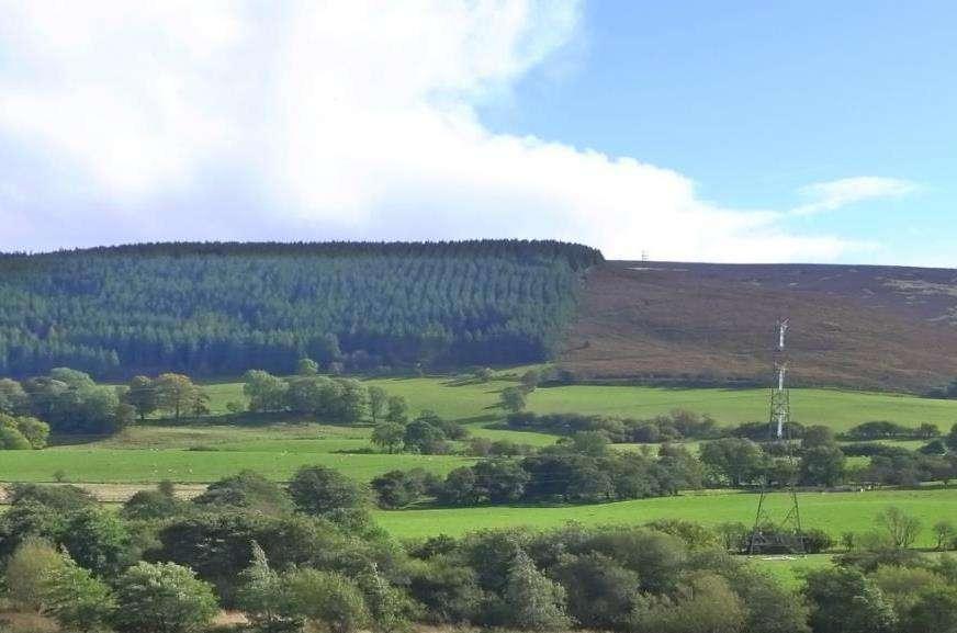
7 Landscape Character, use to Identify key characteristics, qualities and distinctiveness Understand what is important and why Historic character, context, value and patterns Relate to opportunities for change & management guidelines Inform forest design Is woodland already a characteristic of the landscape? What type of woodland: broadleaved/conifer/mixed? Scale of landscape and woodland: large or small copses? How can woodland relate to landform? Will it contribute positively to character and scenic quality? Will it contribute to special qualities, designed landscapes? Where can I find this information?

8 Landscape and visual sensitivities to change Designated and highly valued landscapes Strong sense of place Historic field patterns, features, designed landscape Prominent natural skyline, distinct features, rock outcrops Very open with fragile habitats e.g. marsh, bog, heath, species-rich grassland High visibility overall (landform) and importance of views Scale: open and panoramic, enclosed and intimate Receptors: settlements/roads/prows/open Access/National Trails Sensitivity of receptors: residents/visitors/viewpoints, landscapes of high value


9 Landscape Character Assessment Landscape summary, key characteristics, qualities, sense of place National Landscape Landscape Character LANDMAP 5 spatial datasets Character Areas Areas National scale Regional/authority scale Local scale 48 NLCAs + management guidelines + management guidelines + evaluation landscape importance + most detailed resource to use


10 LANDMAP landscape baseline Detailed surveys of landscape information Understand historic landscape patterns Interrelationships between people, places and resources Important characteristic features: retain visibility to, integrate in open ground Opportunities and management recommendations Geological Landscape Visual & Historic Cultural Landscape Habitats Sensory Landscape Landscape ~ surveys 10

 National")

11 Seascape Character Assessment Seascape summary, key characteristics, qualities, sense of place, relationship land and sea National Marine Seascape Character Seascape Character Assessment Character Areas Areas (Ynys Mon, SNPA, PCNPA) National scale 50 at national scale Local scale SCA for coastal 29 MCAs + management guidelines woodlands + management guidelines + most detailed resource to use
: conserve and enhance natural beauty, take into account needs of agriculture, forestry, rural industries, economic and social needs.")
12 Landscape Designations National Parks (3) purposes: conserve and enhance natural beauty, wildlife and cultural heritage and to promote opportunities for understanding and enjoyment of the special qualities Areas of Outstanding Natural Beauty (5): conserve and enhance natural beauty, take into account needs of agriculture, forestry, rural industries, economic and social needs. Meet recreation demand when consistent with conservation of natural beauty 25% Wales internationally designated by law, nationally important, equal status - living, working landscapes Management Plan identifying special qualities, Action Plan, State of Report Special Landscape Areas High landscape importance, non-statutory but within LDP/SPG Designated for their intrinsic physical, environmental, visual, cultural and historical value Use SLA descriptions to understand what is important, key characteristics to retain and opportunities for improvement
13 Heritage Coasts (14) Scenically outstanding, undeveloped, unspoilt coast, inland to ~1.5 miles Register of Historic Parks & Gardens (statutory) (~400) Protect and conserve historic and visual character and manage change Register of Landscapes of Historic Interest in Wales (58) To understand Outstanding and Special historic interest and character LANDMAP Landscape Baseline for Wales Outstanding and High evaluated landscapes are of national and county importance UNESCO World Heritage Sites (3 + 1 candidate) UNESCO Geoparks (2) Tranquil Areas Map of Wales

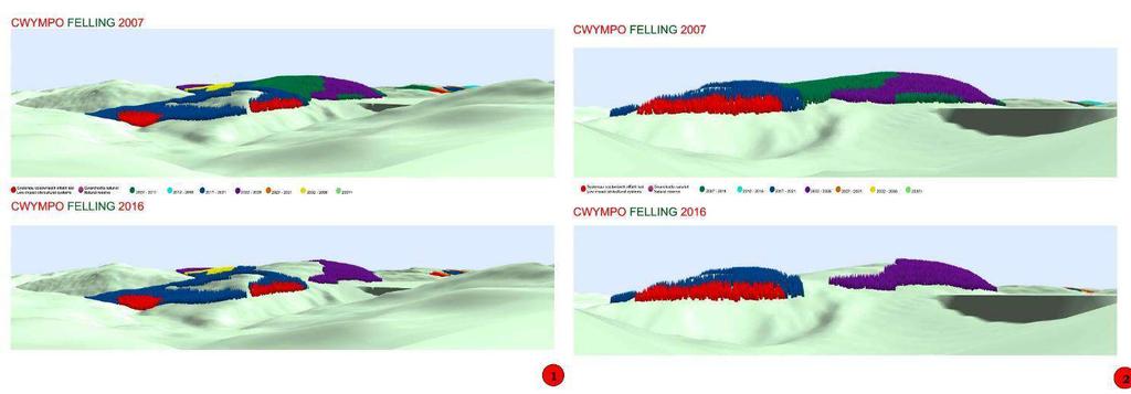
14 Where existing forests do not meet the UKFS Requirements for Forests and Landscape, improvements should be made when management opportunities arise New planting Felling and restocking Design does not meet UKFS requirements Forests should be designed and managed to take account of:


15 Shape in the landscape Forest boundaries, graded edges, interlocking shapes Perceived internal shapes from species, coupes, roads What are dominant influences: landform/landcover? Use landform: irregular/rugged, rolling mosaics/field patterns? Discordant/pleasing? Natural patterns and forms, integration, outliers? Link to landscape character and pattern? Geometric/regular or organic


16 Landform as a dominant influence Visual forces Up the valleys, hollows, concave landforms take treeline higher Down the spurs, ridges, convex landforms drop treeline Flat landscapes drawn to horizons Don t cut across landform with virtual rulers! Careful on crossing skylines, or favour low points Don t slavishly follow fence lines when landform is prominent Think branches & twigs landform general shape form & finer landform for edges
 Wooded Landscape")


17 Enclosure as a dominant influence Irregular Fieldscape Winding lanes, species+ hedgerows, copses, AW Regular Fieldscape Geometric shapes, plantations (medieval/strip/enclosure) Wooded Landscape >50% cover Mosaic landscapes woodland patchwork 20-50%, <10ha, hedgerow trees (59% Wales) Reinforce/relate to existing fieldscape pattern Relate woodlands to hedgerows and hedgerow trees Strengthen woodland/mosaic character where decline is evident Enhance connectivity Don t mask important historic fieldscapes Extensive forests in enclosed areas are less appropriate, consider multiple medium


18 Scale Relationship of key elements (e.g. woodland) within the whole landscape. Intimate: personal scale, gardens Small: community scale, woodland clearings, small field or woodland units, restricted views Medium: moderate scale Large: observer feels small, wide valleys or woodlands Vast: mountain ranges, extensive forests, plains (scale may increase with expanse of view) Important for size of woodland and management units: coupes, species, open spaces Smaller scale in valley bottoms, increasing in scale on hilltops and mountains 1/3 rd and 2/3 rds Oddities: small blocks isolated in an open large landscape skyline scaling
 Diverse: Widespread variation, broad range of elements")


19 Diversity of elements, form, colour, texture Uniform: Unvarying Simple: Little variation (not = landscape value, character or quality) Diverse: Widespread variation, broad range of elements Complex: Complete variation, little recognisable pattern Diversity Seasonal interest can introduce diversity Diversity of structure/age and species composition appears as different textures Features, water, open areas, geological/historic features, Panoramic/framed views Diversity may be more characteristic of lowlands than uplands Work with landscape character, important to retain local distinctiveness


20 Unity Repetition of similar elements or qualities to give a sense of unity/consistency Unity: Woodlands are in harmonious character with landscape Well integrated woodlands that appear to of belong Disunity: Significant disruption to sense of unity Unbalanced, not compatible, jar (size/shape/edges/monotony )


21 Spirit of place, Special Tranquillity Spiritual response Sense of place Veteran trees Rocks and deep mosses Historic monuments Intangible cultural heritage Water Breathtaking views Types of views/viewers Conserve and enhance Provide access to Network and connect with

22 Management and visibility in historic landscapes
23
24
25
26


27 All Landscapes matter Contribute to local landscape character and distinctiveness Understand sensitivity and value Retain the experience of sense of place Locally appropriate landscape change Conserve and enhance important landscapes Enhance landscapes to contribute to wellbeing Apply Forest Design principles for positive outcomes Opportunity to improve existing woodlands Long wooded landscape legacy for new Diolch Thankyou
LANDMAP Methodology Overview
 LANDMAP Methodology Overview June 2017 Jill Bullen, Senior Landscape Specialist jill.bullen@cyfoethnaturiolcymru.gov.uk 0300 065 4706 (Please note this is an information document and not a training presentation)
- - - Key Characteristics
 S23 Dyffryn Dysynni Reproduced from the Ordnance Survey map with the permission of Ordnance Survey on behalf of the Controller of Her Majesty s Stationery Office, Crown copyright Licence No. 100023387
Lower Sensitivity. VS Classification Level 2: Exposed Upland/Plateau
 S05 Y Moelwynion Reproduced from the Ordnance Survey map with the permission of Ordnance Survey on behalf of the Controller of Her Majesty s Stationery Office, Crown copyright Licence No. 100023387 Location
LANDSCAPE CHARACTER ASSESSMENT
 THE COUNTY DURHAM LANDSCAPE CHARACTER ASSESSMENT FOREWORD The landscape of County Durham is one of great contrast and diversity. From the North Pennines in the west to the Durham Coast in the east it contains
S08 Dyffryn Y Ddwyryd
 S08 Dyffryn Y Ddwyryd Reproduced from the Ordnance Survey map with the permission of Ordnance Survey on behalf of the Controller of Her Majesty s Stationery Office, Crown copyright Licence No. 100023387
Lower Sensitivity. VS Classification Level 2: Hills, Lower Plateau & Scarp Slopes (74%)/ Lowland Valleys (17%) / Exposed Upland/Plateau (7%)
/ Lowland Valleys (17%) / Exposed Upland/Plateau (7%)") S06 Coedwig Gwydyr Reproduced from the Ordnance Survey map with the permission of Ordnance Survey on behalf of the Controller of Her Majesty s Stationery Office, Crown copyright Licence No. 100023387 Location
S06 Coedwig Gwydyr Reproduced from the Ordnance Survey map with the permission of Ordnance Survey on behalf of the Controller of Her Majesty s Stationery Office, Crown copyright Licence No. 100023387 Location
LANDSCAPES FOR EVERYONE: CREATING A BETTER FUTURE. A shared vision of why we must treasure our landscapes and how Government can help
 LANDSCAPES FOR EVERYONE: CREATING A BETTER FUTURE A shared vision of why we must treasure our landscapes and how Government can help BRITAIN S DIVERSE LANDSCAPES NEED CHAMPIONS A consortium of national
Lower Sensitivity. VS Classification Level 2: Exposed Upland/Plateau
 S02 Y Carneddau Reproduced from the Ordnance Survey map with the permission of Ordnance Survey on behalf of the Controller of Her Majesty s Stationery Office, Crown copyright Licence No. 100023387 Location
SUSTAINABLE MANAGEMENT
 . Sustainable Management.1 The Concept of Sustainable Management The concept of sustainable management recognises there are limits to the use of natural and physical resources and there is a need to balance
Lower Sensitivity. VS Classification Level 2: Exposed Upland/Plateau
 S04 Moel Hebog Reproduced from the Ordnance Survey map with the permission of Ordnance Survey on behalf of the Controller of Her Majesty s Stationery Office, Crown copyright Licence No. 100023387 Location
Landscape Guidelines. Landscape type: Valley Pasture Character areas: Frome Valley Pasture Stour Valley Pasture. Landscape change
 Landscape type: Valley Pasture Character areas: Frome Valley Pasture Stour Valley Pasture The valley pasture landscape type is found along the lower reaches of the Stour and Frome, formed from alluvial
Potential sources of guidance for EIA opinions and consents for Glastir Woodland Creation schemes
 EIA guidance Potential sources of guidance for EIA s and consents for Glastir Woodland Creation schemes Every Glastir Woodland Creation plan requires an Environment Impact Assessment (EIA) to assess whether
LANDSCAPE GUIDELINES. Countryside & Coastal Countryside Environments. Landscape, Natural Character & Amenity Values Guide
 Landscape, Natural Character & Amenity Values Guide Copyright WDC 2009 Version A2 18May09 Environmental Services Group Publication Countryside & Coastal Countryside Environments START HERE Quality Land
Lower Sensitivity. VS Classification Level 2: Exposed Upland/Plateau (86%)/ Upland Valleys (10%)
/ Upland Valleys (10%)") S09 Y Mignient Reproduced from the Ordnance Survey map with the permission of Ordnance Survey on behalf of the Controller of Her Majesty s Stationery Office, Crown copyright Licence No. 100023387 Location
S09 Y Mignient Reproduced from the Ordnance Survey map with the permission of Ordnance Survey on behalf of the Controller of Her Majesty s Stationery Office, Crown copyright Licence No. 100023387 Location
Wind energy development in the South Pennines landscape
 Wind energy development in the South Pennines landscape Programme for today Background Policy context South Pennines landscape Impacts of wind energy development The South Pennines Wind Energy Landscape
Tables of Criteria and Matrices for Landscape Assessment (LSCA & LVIA)
") Carly Tinkler CMLI Environmental, Landscape and Colour Consultancy 46 Jamaica Road, Malvern, Worcestershire WR14 1TU Tel +44 (0)7711 538854 carlytinkler@hotmail.co.uk Tables of Criteria and Matrices for
Carly Tinkler CMLI Environmental, Landscape and Colour Consultancy 46 Jamaica Road, Malvern, Worcestershire WR14 1TU Tel +44 (0)7711 538854 carlytinkler@hotmail.co.uk Tables of Criteria and Matrices for
6 Landsc apes and rur al char ac
 LANDSCAPES AND RURAL CHARACTER QLDC PROPOSED DISTRICT PLAN [PART TWO] DECISION VERSION ter 6 Landsc apes and rur al char ac 6.1 Purpose Appendix C QLDC DISTRICT PLAN [PART TWO] DECISION VERSION 6 Landsc
S18 Mynyddoedd Yr Aran
 S18 Mynyddoedd Yr Aran Reproduced from the Ordnance Survey map with the permission of Ordnance Survey on behalf of the Controller of Her Majesty s Stationery Office, Crown copyright Licence No. 100023387
PART 5 - NATURAL AND PHYSICAL ENVIRONMENT
 CONTENTS...PAGE 5.1 INTRODUCTION...3 5.2 NATURAL RESOURCES...4 5.3 PHYSICAL RESOURCES...4 5.4 COASTAL ENVIRONMENT...4 5.5 HERITAGE FEATURES...4 5.6 HAZARDS...4 5.7 SUMMARY...4 ISTHMUS SECTION - OPERATIVE
Guidance for Wind Turbine Development in the Dorset AONB
 Photo 1: Rew Manor Farm, West Dorset, chalk downland landscape (Planning application ref: 1/D/09/001280 1 ) Scale & siting: 12m to hub / 16m to blade tip. A well sited small scale turbine, grouped with
Guidance for Wind Turbine Development in the Dorset Area of Outstanding Natural Beauty
 DRAFT January 2012 Guidance for Wind Turbine Development in the Dorset Area of Outstanding Natural Beauty Photo 1: Rew Manor Farm, West Dorset, chalk downland landscape (Planning application ref: 1/D/09/001280
LANDSCAPE CHARACTER ASSESSMENT INFORMING and FACILITATING CHANGE LISW CPD DAY
 LANDSCAPE CHARACTER ASSESSMENT INFORMING and FACILITATING CHANGE LISW CPD DAY Christine Tudor BA Hons, Dip LP., MPhil., CMLI, FRGS. Senior Specialist Landscape & Seascape 1 The need for informed Change
Landscape Guidelines. Landscape type: Chalk Ridge/Escarpment Character areas:
 Landscape type: Chalk Ridge/Escarpment Character areas: Purbeck Ridge North Dorset Escarpment South Dorset Escarpment West Dorset Escarpment Landscape change Policy driven farming changes over the last
Appendix One. Landscape. Areas of Outstanding Landscape Value: Criteria for Selection. Landscape Character
 Areas of Outstanding Value: Criteria for Selection The dimensions of landscape are landscape character and landscape quality. The analysis of landscape character and quality draws heavily on the visual
Statutory and Non-Statutory Designated Sites and Ecology
 Statutory and Non-Statutory Designated Sites and Ecology The National Planning Policy Framework considers the conservation and enhancement of the natural environment in chapter 11 paragraphs 109-119, where
Rolling Wooded Pasture Lulworth Wooded Pasture Rempstone Wooded Pasture
 Landscape type: Character areas: Rolling Wooded Pasture Lulworth Wooded Pasture Rempstone Wooded Pasture The rolling wooded pasture landscape type is found around the margins of the Dorset Heaths. Although
Visual Impact Rating Form - Instructions
 Visual Impact Rating Form Instructions Project Name: Baron Winds Project EDR Project No: 13039 Date: 05.16.17 Reference: Visual Impact Rating Form - Instructions These instructions are intended to guide
Landscape Guidelines. Landscape type: Wooded Hills Character areas: Landscape change. Planning guidelines
 Landscape type: Wooded Hills Character areas: Axe Valley Hills Wootton Hills Chideock Hills Powerstock Hills Powerstock Woods Landscape change Policy driven farming changes over the last sixty years, resulting
TOPIC PAPER 2: Links to other sustainability tools
 TOPIC PAPER 2: INTRODUCTION 1.1 Landscape Character Assessment can inform a range of other sustainability tools and methodologies. Equally these other tools may assist in reaching decisions concerning
coastal plain coastal plain
 NORFOLK O R F O L K COAST C O A SAONB T A O NIntegrated B I n t elandscape g r a t e d L Guidance a n d s c a p e G u i d a n c e 1 Integrated landscape character MAP 23a - Coastal Plain Key Plan This
North York Moors National Park Authority Planning Committee
 Item 8 North York Moors National Park Authority Planning Committee 12 December 2013 Consultation from Redcar and Cleveland Borough Council on proposed Wind Farm at Bank Field Guisborough 1. Purpose of
Cotswolds AONB Landscape Strategy and Guidelines. June 2016
 Cotswolds AONB Landscape Strategy and Guidelines June 2016 Cotswolds AONB Landscape Strategy and Guidelines Introduction The evolution of the landscape of the Cotswolds AONB is a result of the interaction
Northland Regional Landscape Assessment Worksheet
 Northland Regional Landscape Assessment Worksheet DESCRIPTION AND CHARACTERISATION Component Land Types (refer to list overleaf) Volcanic cones Geology (including geopreservation sites) Soil Types Unit
A Research Framework for the Archaeology of Wales Version 01, Final Paper Neolithic and Earlier Bronze Age
 NEOLITHIC AND EARLIER BRONZE AGE Introduction The introduction of farming around 4000 BC had a dramatic impact on the landscape of Wales and fundamentally changed they ways in which people lived and interacted.
Landscape values, people and change
 Landscape values, people and change Chris Bolton, Principal Specialist, Landscape Europarc Conference, Killarney 1 st October 2014 Topics ELC, CBD, Ecosystem services - Integration Natural and Social science
Settlement Boundaries Methodology North Northumberland Coast Neighbourhood Plan (August 2016)
") Introduction This background paper sets out a methodology for the definition of settlement boundaries in the North Northumberland Coast Neighbourhood Plan. The neighbourhood plan is planning positively
Introduction This background paper sets out a methodology for the definition of settlement boundaries in the North Northumberland Coast Neighbourhood Plan. The neighbourhood plan is planning positively
Landscape Policy in Ireland insights from the Heritage Council
 Landscape Policy in Ireland insights from the Heritage Council Ian Doyle Head of Conservation What am I going to talk about? What is landscape? European Landscape Convention Local landscape projects Methods
DESIGN AND MANAGEMENT PART 3 HA 57/92 NEW ROADS INTEGRATION WITH RURAL LANDSCAPES SUMMARY
 DESIGN MANUAL FOR ROADS AND BRIDGES VOLUME 10 SECTION 1 ENVIRONMENTAL DESIGN AND MANAGEMENT NEW ROADS PART 3 HA 57/92 NEW ROADS INTEGRATION WITH RURAL LANDSCAPES SUMMARY This Advice Note gives guidance
25/08/2017 1
 1 2 3 4 5 6 Position of the observer at the same level of the viewing plane Position of the observer at the same level of the viewing plane 7 Lower position of the observer with respect to the plane Lower
Response to Review Panel Stage 2 Consultation on Designated Landscapes in Wales. UK Environmental Law Association s Wales Working Party
 Response to Review Panel Stage 2 Consultation on Designated Landscapes in Wales UK Environmental Law Association s Wales Working Party The UK Environmental Law Association (UKELA) aims to make the law
WALES ONLY INTERIM ADVICE NOTE 135/10 (W) LANDSCAPE AND VISUAL EFFECTS ASSESSMENT
 LANDSCAPE AND VISUAL EFFECTS ASSESSMENT") Interim Advice Note 135/10 (W) Landscape and Visual Effects Assessment INTERIM ADVICE NOTE 135/10 (W) LANDSCAPE AND VISUAL EFFECTS ASSESSMENT WALES ONLY Summary This Interim Advice Note provides instructions
Interim Advice Note 135/10 (W) Landscape and Visual Effects Assessment INTERIM ADVICE NOTE 135/10 (W) LANDSCAPE AND VISUAL EFFECTS ASSESSMENT WALES ONLY Summary This Interim Advice Note provides instructions
Environmental Assessment (Scotland) Act 2005: Clackmannanshire Council Sustainability Strategy Scoping Request
 Act 2005: Clackmannanshire Council Sustainability Strategy Scoping Request") TAYSIDE & CLACKMANNANSHIRE Tel: 01738 458582(direct line) Fax: 01738 458616 e-mail addresses: denise.reed@snh.gov.uk Niall Urquhart Team Leader Sustainability Clackmannanshire Council Kilncraigs Greenside
TAYSIDE & CLACKMANNANSHIRE Tel: 01738 458582(direct line) Fax: 01738 458616 e-mail addresses: denise.reed@snh.gov.uk Niall Urquhart Team Leader Sustainability Clackmannanshire Council Kilncraigs Greenside
B - Coalfield River Corridor Landscape Character Type
 B - Coalfield River Corridor Landscape Character Type Landscape Character Type - Coalfield River Corridor The Coalfield River Corridors Landscape Character Type is located in the two converging valleys
tributary farmland tributary farmland
 NORFOLK O R F O L K COAST C O A SAONB T A O NIntegrated B I n t elandscape g r a t e d L Guidance a n d s c a p e G u i d a n c e 1 Integrated landscape character MAP 23a - Landscape Character Type - Tributary
Woodland Conservation and the Master Plan
 1 WHAT IS A MASTER PLAN? A Vision for the Future of Your Community Woodland Conservation and the Master Plan Goals Objectives Strategies 2 How Will Your Community Look? TREE PRESERVATION AND THE MASTER
Daugleddau. Seascape Character Area Name: No: Near Picton Point on Daugleddau. Looking east from Cleddau Bridge. Ancient oaks at water's edge
 No: 33 Seascape Character Area Name: Daugleddau Near Picton Point on Daugleddau Ancient oaks at water's edge Looking east from Cleddau Bridge 33-1 Summary Description The reaches of the Daugleddau and
Blackdown Hills Area of Outstanding Natural Beauty Management Plan
 Blackdown Hills Area of Outstanding Natural Beauty Management Plan 2014 2019 The Blackdown Hills Area of Outstanding Natural Beauty (AONB) covers 370 square kilometres (143 square miles) of unspoilt countryside
Summary Note on Landscape and Visual Impact and Mitigation
 East Anglia TWO Offshore Windfarm Appendix 4.4 Summary Note on Landscape and Visual Impact and Mitigation Preliminary Environmental Information Volume 3 Document Reference EA2-DEVWF-ENV-REP-IBR- 000799_004
our Vision The Dorset Area of Outstanding Natural Beauty Partnership is working towards a future in which:
 The Dorset Area of Outstanding Natural Beauty Partnership is working towards a future in which: our Vision Local people and visitors are inspired by the Area of Outstanding Natural Beauty (AONB) landscape
ICOMOS-IFLA PRINCIPLES CONCERNING RURAL LANDSCAPES AS HERITAGE
 ICOMOS-IFLA PRINCIPLES CONCERNING RURAL LANDSCAPES AS HERITAGE Adopted by the 19th ICOMOS General Assembly, New Delhi, India, 15 December 2017 PREAMBLE Rural landscapes are a vital component of the heritage
Route Alignment Options Summary Report
 Brechfa Forest Connection Project February 2014 Summary report 1. RSK Environment Ltd (RSK) was commissioned by Western Power Distribution (WPD) to provide environmental consultancy support services for
Wildlife and Countryside Link s Landscape Scale Conservation position statement
 Wildlife and Countryside Link s Landscape Scale Conservation position statement February 2010 Wildlife and Countryside Link (Link) brings together over 30 voluntary organisations concerned with the conservation
Review of East Dunbartonshire Local Landscape Areas, A Light Touch Review
 Review of East Dunbartonshire Local Landscape Areas, A Light Touch Review Local Landscape Area (LLA) Review in Local Development Plan Process 2011 - SNH advise existing landscape designations are reviewed
Appendix 17A Scenic Quality Rating Forms
 1 2 Appendix 17A Scenic Quality Rating Forms UNITED STATES DEPARTMENT OF THE INTERIOR BUREAU OF LAND MANAGEMENT SCENIC QUALITY RATING SUMMARY Date: March 7, 2018 Landscape Character Unit: N/A Key Observation
DUNSFOLD NEIGHBOURHOOD PLAN Site Selection Policies
 DUNSFOLD NEIGHBOURHOOD PLAN Site Selection Policies The criteria for assessing sites for future housing and business development in Dunsfold are set out below. (Development criteria, covering what it is
North York Moors National Park. Management Plan A WIDER VIEW
 North York Moors National Park Management Plan A WIDER VIEW North York Moors National Park Management Plan A WIDER VIEW Adopted November 2012. First review: December 2016. Copyright 2012 North York Moors
Seascapes and Marine Planning in Wales
 Wales Landscape Partnership Seascapes and Marine Planning in Wales Synopsis of technical Seminar The Future Inn, Cardiff Bay Tuesday 25 th March 2014 Seascapes and Marine Planning in Wales Page 1 SEASCAPES
GREEN NETWORK APPLICATIONS IN ESTONIA
 GREEN NETWORK APPLICATIONS IN ESTONIA Kalev Sepp, Tuuli Veersalu, Martk Külvik Estonian University of Life Sciences 1 WHY? BACKGROUND - POLITICAL By adopting the Pan-European Biological and Landscape Diversity
UNCLASSIFIED. Risk of Flooding from Reservoirs - Severn River Basin District
 UNCLASSIFIED Flood Risk Maps Risk of Flooding from Reservoirs - Severn Why have we produced these maps what can they be used for? Under the Flood Risk Regulations Natural Resources Wales have worked in
Brockholes Wetland and Woodland Nature Reserve, Preston Lancashire
 Newlands Brockholes Wetland and Woodland Nature Reserve, Preston Lancashire Nature s Gateway to Lancashire NEWLANDS Brockholes: site profile Brockholes Wetland and Woodland Nature Reserve project area
IDENTIFY, ANALYSE, CHARACTERISE THE LANDSCAPE TO ACT, IMPROVE THE KNOWLEDGE
 WORKSHOP I: Wednesday 2 October Thursday 3 October 2013 Ingrid Sarlöv Herlin ECLAS, SLU, Alnarp, Sweden, Graham Fairclough Univ. of Newcastle, UK IDENTIFY, ANALYSE, CHARACTERISE THE LANDSCAPE TO ACT, IMPROVE
Toddington Central Bedfordshire Stage 3 Green Belt Study December 2017
 Toddington Central Bedfordshire Stage 3 Green Belt Study December 2017 Site: ALP086 - Middle Lakes, Toddington Site size (ha): 2.83 Site: ALP086 - Middle Lakes, Toddington Site size (ha): 2.83 Site description
Priority Delivery Areas for Landscape Scale Conservation in the South West ( )
") Priority Delivery Areas for Landscape Scale Conservation in the South West (2011-15) Together, this set of Biodiversity Delivery Areas (BDAs) represents an ambitious vision to establish a network of strategic
Priority Delivery Areas for Landscape Scale Conservation in the South West (2011-15) Together, this set of Biodiversity Delivery Areas (BDAs) represents an ambitious vision to establish a network of strategic
ROCHFORD LOCAL DEVELOPMENT FRAMEWORK: Sustainability Appraisal/ Strategic Environmental Assessment. Rochford Core Strategy Preferred Options Document
 ROCHFORD LOCAL DEVELOPMENT FRAMEWORK: Sustainability Appraisal/ Strategic Environmental Assessment Non Technical Summary Rochford Core Strategy Preferred Options Document October 2008 SUSTAINABILITY APPRAISAL
The analysis of key visual characteristics and attributes that contribute to variations in the
 15.0 CHIGWELL/CHIGWELL ROW 15.1 Overview 15.1.1 Chigwell and Chigwell Row settlements are situated in the south of Epping Forest District, to the south of Abridge and southwest of Stapleford Abbotts. Both
7. Landscape. Introduction
 Introduction Our landscapes provide us with a Marlborough identity and are an integral part of the Marlborough environment. Landscapes are distinct spatial areas influenced by location-specific processes
World Heritage Cultural Landscapes
 International Expert Workshop on Integrity & Authenticity of World Heritage Cultural Landscapes Dec 11, 2007 - Dec 12, 2007 Aranjuez, Spain Patricia M. O Donnell, FASLA, AICP, IFLA, ICOMOS Heritage Landscapes,
North York Moors National Park Authority
 North York Moors Item 10 25 June 2012 Review of National Park Management Plan 1. Purpose of the Report 1.1 To present the final version of the Plan for formal adoption by the Authority. 2. Introduction
Suffolk Coast & Heaths Area of Outstanding Natural Beauty Management Plan Landscapes for Life Logo SCH AONB Logo
 Suffolk Coast & Heaths Area of Outstanding Natural Beauty Management Plan 2018-2023 Landscapes for Life Logo SCH AONB Logo 1 CONTENTS FOREWORD SECTION 1: Introduction and Document Purpose 1.1 Introduction
B4. Te tiaki taonga tuku iho - Natural heritage
 B4. Te tiaki taonga tuku iho - Natural heritage Tuia I runga, tuia i raro, tuia ki te waonui a Tiriwa Bind the life forces of heaven and earth to the great realm of Tiriwa B4.1. Issues Auckland s distinctive
Scottish Natural Heritage. Better places for people and nature
 Scottish Natural Heritage Better places for people and nature Contents Summary... 3 SNH approach... 5 Place-making in policy and practice... 6 Developing the contribution of the natural heritage to place-making...
APPENDIX 4. 5 ST AGNES LOCAL LANDSCAPE CHARACTER ASSESSMENT TABLE ST AGNES BEACON
 APPENDIX 4. 5 ST AGNES LOCAL LANDSCAPE CHARACTER ASSESSMENT TABLE ST AGNES BEACON CHARACTER AREA: ST AGNES BEACON DATE OF ASSESSMENT May 2016 Character Attribute Landscape reference guide ST AGNES BEACON
3.1 This evidence is based on the landscape and visual impact assessment included in Chapter 10 and Appendix I of the EIS.
 LANDSCAPE & VISUAL 1 QUALIFICATIONS AND EXPERIENCE 1.1 My name is Raymond Holbeach and I am a Regional Director for RPS Planning & Environment with full responsibility for management of the RPS Belfast
Snowdonia National Park Authority: Eryri Local Development Plan
 Snowdonia National Park Authority: Eryri Local Development Plan Strategic Environmental Assessment and Sustainability Appraisal SA Report Addendum - Proposed s (September 2010) CHAPTER 1: INTRODUCTION
South West Nature Map - A Planners Guide
 South West Nature Map - A Planners Guide Helping to Shape Spatial Planning for Biodiversity in Local Development Frameworks Working together for wildlife CONTENTS Foreword 1.0 Introduction 1.1 Purpose
Section 6A 6A Purpose of the Natural Features and Landscapes Provisions
 Section 6A 6A Purpose of the Natural Features and Landscapes Provisions This Chapter addresses the protection and management of natural features and landscapes within the City. The City has a number of
Wageningen Environmental Research
 Wageningen Environmental Research Monitoring the touristic values of European landscape 10-2-2017, Martin Goossen Overview - Introduction - Application - Results - Conclusion Introduction Mires and bogs
INTERIM ADVICE NOTE 135/10 LANDSCAPE AND VISUAL EFFECTS ASSESSMENT
 Interim Advice Note 135/10 INTERIM ADVICE NOTE 135/10 LANDSCAPE AND VISUAL EFFECTS ASSESSMENT Summary This Interim Advice Note provides instructions on the assessment of landscape and visual effects of
Appendices. Contents. Appendices - Sep 1997 CP-1 AP-1
 Appendices Contents 1. Goals for Protected Areas in British Columbia... AP-3 2. Guiding Principles for Protected Areas... AP-4 3. Resource and Recreation Use Guidelines for Protected Areas... AP-5 4. Aboriginal
Criteria for the Selection of SINCs in the Mid-Valleys Area
 Criteria for the Selection of Sites of Importance for Nature Conservation in the County Boroughs of Blaenau Gwent, Caerphilly, Merthyr Tydfil and Rhondda Cynon Taff (the Mid-Valleys Area ) Prepared by
Neighbourhood Planning Local Green Spaces
 Neighbourhood Planning Local Green Spaces Introduction... 2 1. Why green space is important... 4 2. Neighbourhood plans and green space... 6 3. Evidence... 8 Statutory designations... 9 Green space audit...
A Sense of Tranquillity, A Strong Feeling of Remoteness and Dark Night Skies
 A Sense of Tranquillity, A Strong Feeling of Remoteness and Dark Night Skies A Consultation About Planning Policy This document sets out our current thinking on how we may develop new planning policy for
Viewpoint 1. Location: View from Murch Road on the north eastern boundary of Application Site. Viewing south / southwest.
 Application Site (eastern field) Former site of St. Cyres Lower School Murch Road 1 Location: View from Murch Road on the north eastern boundary of Application Site. Viewing south / southwest. Baseline
Landscape Character Assessment
 Landscape Character Assessment What Is It? Survey of the county landscapes For what purpose? To analyse and define character Says Who? Planning and Development Act 2000 Applications To provide a basis
Stockport Landscape Character Assessment and Landscape Sensitivity Study Produced for Stockport Metropolitan Borough Council
 Stockport Landscape Character Assessment and Landscape Produced for Stockport Metropolitan Borough Council Final Report Prepared by LUC August 2018 Front cover photograph: The edge of Ludworth Moor, looking
Tāhuhu whakaruruhau ā-taone The sheltering ridge pole
 B2. Tāhuhu whakaruruhau ā-taone - Urban growth and form B2.1. Issues Tāhuhu whakaruruhau ā-taone The sheltering ridge pole Auckland s growing population increases demand for housing, employment, business,
Call for Proposals. Heritage, natural capital and ecosystem services: case studies. Project No: Date of Issue: Tuesday 14 th November 2017
 Call for Proposals Heritage, natural capital and ecosystem services: case studies Project No: 7705 Date of Issue: Tuesday 14 th November 2017 Summary Historic England is seeking expressions of interest
INTEGRATION OF LANDSCAPE IN LAND USE PLANNING POLICY IN RELATION TO THE NEW EUROPEAN LANDSCAPE CONVENTION
 INTEGRATION OF LANDSCAPE IN LAND USE PLANNING POLICY IN RELATION TO THE NEW EUROPEAN LANDSCAPE CONVENTION Prof. Michel PRIEUR C.R.I.D.E.A.U. FRE 6062 CNRS/INRA UNIVERSITY OF LIMOGES - FRANCE MAY 2004 The
Glossary. Acceptable Levels of Quality The lowest standard permissible in the constituents' view.
 Glossary Acceptable Levels of Quality The lowest standard permissible in the constituents' view. Aesthetics (Esthetics) Generally, the study, science, or philosophy dealing with beauty and with judgments
Draft Stillwater 2030 Comprehensive Plan- Goals and Policies
 Draft Stillwater 2030 Comprehensive Plan- Goals and Policies Instructions- Review each goal and policy and discuss with group any changes, deletions for additions to the list using your groups pen. Keep
CHAPTER 10 AESTHETICS
 CHAPTER 10 AESTHETICS CHAPTER 10 AESTHETICS This section identifies and evaluates key visual resources in the project area to determine the degree of visual impact that would be attributable to the project.
LANDSCAPE CHARACTER AND VISUAL CAPACITY STUDY
 LANDSCAPE CHARACTER AND VISUAL CAPACITY STUDY PROPOSED RESIDENTIAL ALLOCATION BARHAM COURT FARM BARHAM, KENT REF. NO. 3046_ RP_001 STATUS: INFORMATION REVISIONS DOCUMENT CREATED: 10/04/32014 REVISION A
Your Dartmoor SUMMARY
 The National Park Developing the Plan The Plan Delivering the Plan Your Dartmoor SUMMARY Dartmoor National Park Management Plan 2014-2019 2014 www.yourdartmoor.org 1 INTRODUCTION Introduction 1.1 At 954
SETTLEMENT ASSESSMENT PROFORMA
 SETTLEMENT ASSESSMENT PROFORMA Surveyors(s):Clare Sheridan Character Area: Park Estate = Midland Rd, Severn Rd, Festival Rd, Park Rd, Willow Rd, Rylands Rd. Date: Feb Weather: cloudy Look through all the
SOUTH TIPPERARY LANDSCAPE CHARACTER ASSESSMENT PHASE ONE UPLANDS
 CUNNANE STRATTON REYNOLDS SOUTH TIPPERARY LANDSCAPE CHARACTER ASSESSMENT PHASE ONE UPLANDS CUNNANE STRATTON REYNOLDS 3 Molesworth Place, Dublin 2 South Tipperary County Council September 2006 South Tipperary
FERMANAGH AND OMAGH DISTRICT COUNCIL. Position Paper Five. Environmental Assets
 FERMANAGH AND OMAGH DISTRICT COUNCIL Position Paper Five Environmental Assets May 2015 Environmental Assets of Fermanagh and Omagh District Council Purpose: Content: To provide members with an overview
Conserving Nature Through Tourism? Issues of tourism and Protected Areas. Professor Andrew Holden
 Conserving Nature Through Tourism? Issues of tourism and Protected Areas Professor Andrew Holden Kenya video https://www.youtube.com/watch?v=rdck9 SgdEZY Reflection What does the term natural environment
d r a i n e d coastal marshes
 NORFOLK O R F O L K COAST C O A SAONB T A O NIntegrated B I n t elandscape g r a t e d L Guidance a n d s c a p e G u i d a n c e d r a i n e d coastal marshes Annie Cowper Johnson 1 Integrated landscape
Western Sydney Parklands Australia s Largest Urban Park
 Western Sydney Parklands Australia s Largest Urban Park 37 WLA 1 MAGAZINE 21 38 WESTERN SYDNEY PARKLANDS AUSTRALIA S LARGEST URBAN PARK Large urban parks have dual roles to play in meeting the demands
How to win. Saving wildlife sites
 How to win Saving wildlife sites Written by Alan Stanley on behalf of Friends of the Earth Edited by Helen Barron Cover photo by Michael Leach/Oxford Scientific Films ISBN 1857503392 All rights reserved