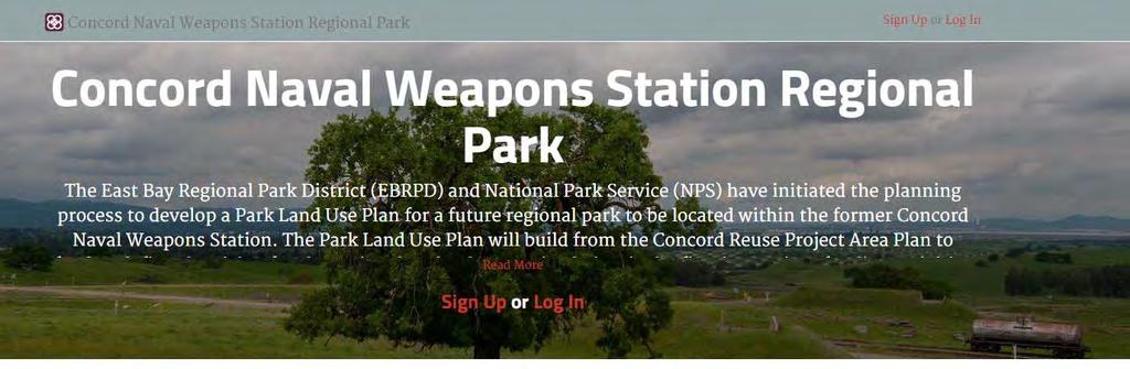
Concord Hills Regional Park Land Use Plan
|
|
|
- Willis Hamilton
- 5 years ago
- Views:
Transcription


1 Photo by Stephen Joseph Public Meeting #2: Design Concepts Review November 19, 2015
 Presentation Project")

 Groups Report")
2 Agenda Photo by Stephen Joseph 1) Welcome 2) Presentation Project Background and Status Existing Conditions, Opportunities, and Constraints Alternatives Overview 3) Small Group Exercise 4) Groups Report Back 5) Conclusions and Next Steps
3 The PlaceWorks Team Leaders in Open Space and Public Access Planning Integrated Science, Planning, Design, and Environmental Review Team Members Include: HT Harvey & Associates (Biology) Siegel & Strain Architects; Trachtenberg Architects Donna Graves (Public History) Land Economics Consultants Timothy C. Best (Geology; Trails) BFK (Engineering) Environmental Science Associates (Cultural Resources, Hydrology, Traffic)
 Beverly Lane,")


4 Key Project Partners East Bay Regional Park District (Lead) Beverly Lane, Director Diane Burgis, Director Brian Holt, Principal Planner National Park Service Gretchen Stromberg, Chief of Planning and Administration City of Concord

5 Project Background and Status Concord Naval Weapons Station EDC Future Regional Park Site

6 Concord Community Area Plan Comprised of 5,046 Acres 786 Acres: City Parks and Greenways 2,537 Acres: Conservation Open Space A transit-oriented district with the flavor of city life 12,000 New Housing Units 6.1 million SF Commercial Community and regional facilities Source: CRP Area Plan, 2012
7 Park Land Use Plan Purpose: Guide Development and Operation of the Future Regional Park Schedule Existing Conditions Report- July 2015 Alternative Park Land Use Plans ( Present- Winter, 2016) Draft Park Land Use Plan (Winter, Spring, 2016) Environmental Review (Winter, Fall, 2016) Adoption of Final Land Use Plan (Late Fall, 2016) Avenues for Community Input: Stakeholder Committee Public Meetings Online Engagement


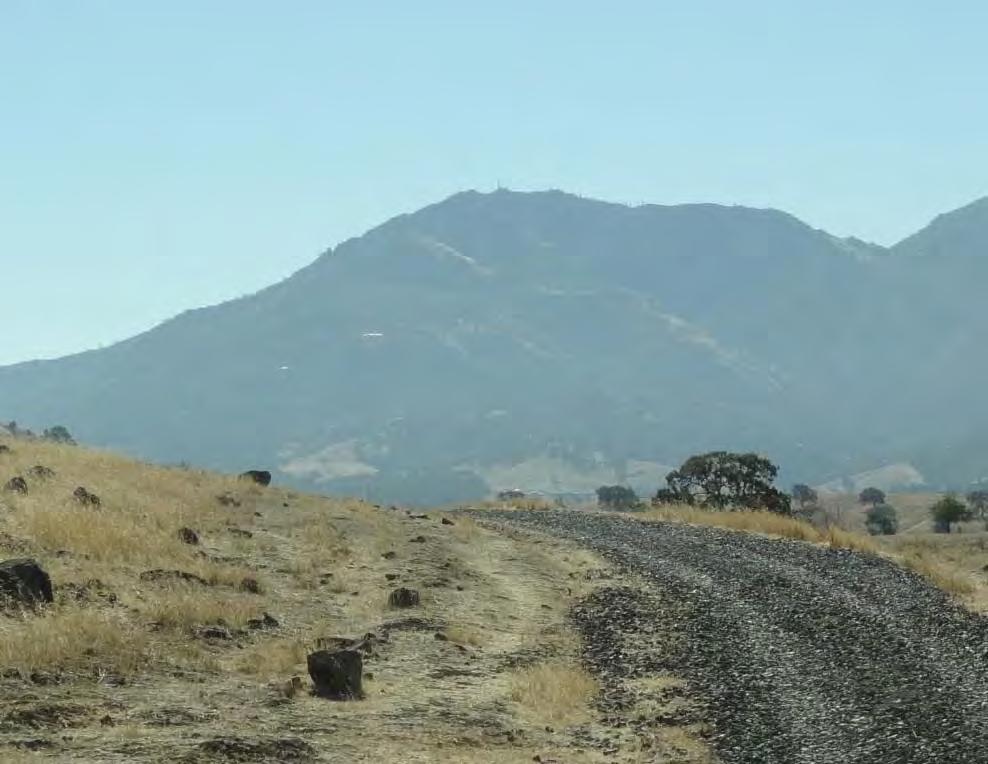
8 Existing Conditions, Opportunities and Constraints Existing Conditions Overview Photo by Stephen Joseph

9 Regional Context Open Space and Trail Connections Black Diamond Mines Regional Park and Mount Diablo State Park Juan Bautista de Anza National Historic Trail Contra Costa Canal to Delta de Anza Regional Trail Community Connections
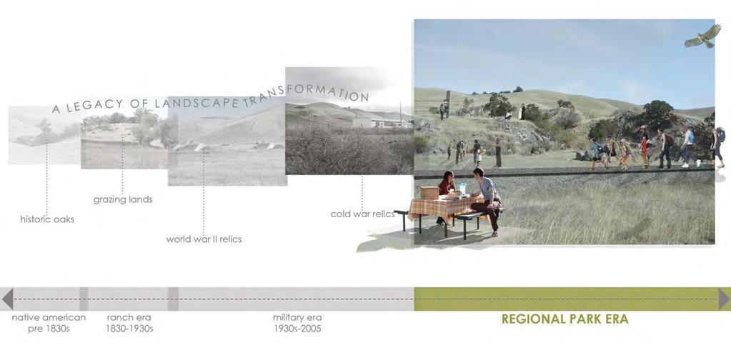
10 Historical Context


 Photo by")
11 Historical Context Native American and Mission Periods (4,000 BCE to 1821) Mexican and Early American Period (1821 to 1895) Cistern Building (Constructed in 1930s) Photo by Stephen Joseph


12 Historical Context Port Chicago Naval Magazine (Est. 1942) Explosion and Mutiny Trial (1944) Source: Allen, The Port Chicago Mutiny, 1993


13 Historical Context Expansion of CNWS to Inland Area (1944) Magazines constructed Civilian Protests Cold War Era Source: Keibel, Behind the Barbed Wire, 2006 Sources: Allen, The Port Chicago Mutiny, 1993 and Lincoln Cushing, Docs Populi


14 Natural Resources Biological Resources I Water Resources I Remediation Underway Photo by Stephen Joseph


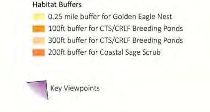
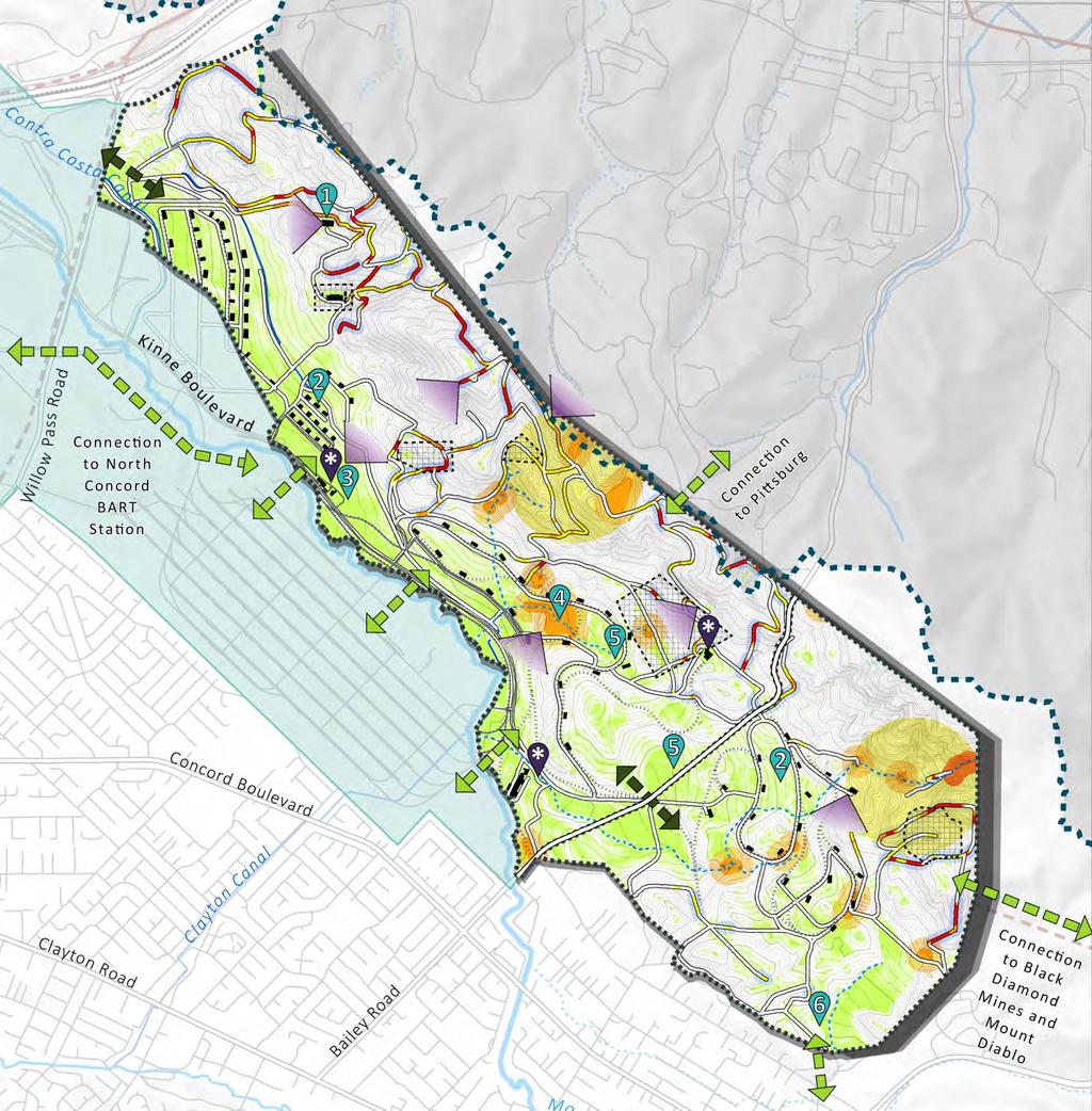
15 Opportunities and Constraints: Natural Resources Conservation Zone 1: No Park Uses Conservation Zone 2: Limited Park Uses Park Use Zone Overlay


16 Road and Rail Network 17.7 miles of paved road 25.3 miles of dirt roads 14.5 miles of railroad Canals Contra Costa Canal Clayton Lateral


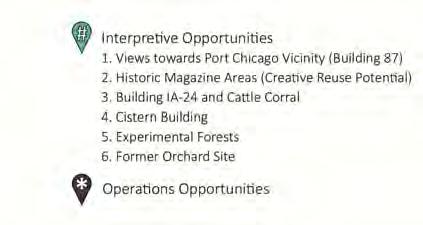
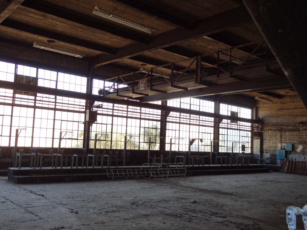
17 Structures Building 87 Building 1A-24 Complex Southwestern Complex Bldg. 97

18 Opportunities and Constraints

19 Opportunities Open Space that is Highly Accessible to Urban Populations A Critical Linkage for Regional Open Space and Trails A Historic and Ecological Landscape that Resonates A Sustainable Park Model Protection of Resources: Biological, Cultural, and Visual


 Resource Reuse")
20 Public Meeting #1: Vision Major Themes: Interpretation of cultural and natural history Access and connectivity Balance park use with conservation Park amenities (camping, magazine use, recreational rail, observatory, concessions) Resource Reuse Sustainability

21 Online Engagement Priorities Ranking

22 Alternative Land Use Concepts
 Recreational Uses Multi-use Trail Network Picnic Areas using Magazines Outdoor Classrooms Camping Amphitheatre Educational/Event")
23 Similarities between Alternatives Resource Protection emphasized in Conservation Zones Access and Circulation Regional Trail Connections Same Vehicular Access Points No through-road (public) Recreational Uses Multi-use Trail Network Picnic Areas using Magazines Outdoor Classrooms Camping Amphitheatre Educational/Event Facility

24 Similarities between Alternatives Joint Use Visitor Center Reuse of Building IA-24 Similar Programming Interpretive Sites and Content Operations Caretaker Residence Corporation Yard at Southwestern Complex

25 Alternatives Overview: Key Differences Approach to Interpretive Programming Road and Trail Network Distribution and type of Park Uses and Facilities Joint Use Visitor Center Complex Approach to Magazine Reuse

26 Alternative A- Interpretive Zones xxx

27 Alternative A- Park Uses and Facilities Northern Area Loop Service and Emergency Road in northern area Caretakers Residence at Building 87 Site Public Road to Visitor Center only

28 Alternative A- Park Uses and Facilities Central and Southern Area Public Road to education/event facility at Building 97 Site Public loop road with picnic areas Ridge trail within Park Multiple loop trails Walk-in Neighborhood Access Backcountry campsite Community Orchard
29 Alternative A: Visitor Center Complex xxx
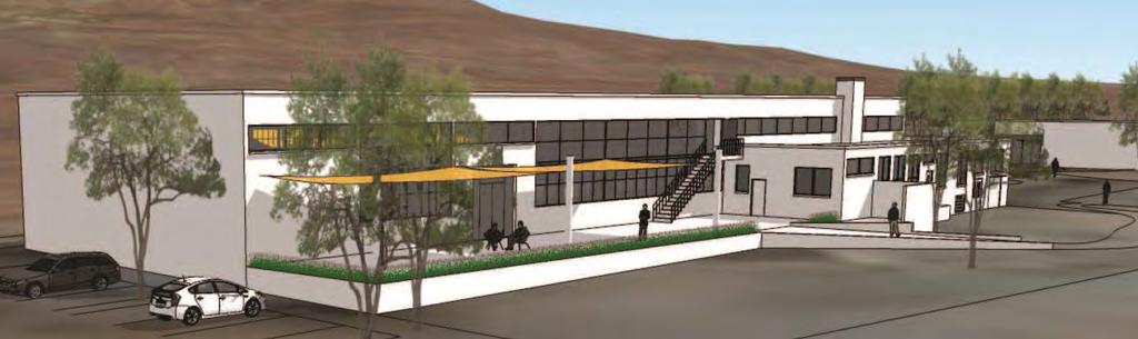
30
31

32 Alternative A: Visitor Center Complex

33 Magazine Reuse xxx
34 Magazine Reuse xxx
35 Magazine Reuse

36 Magazine Reuse: Picnic Facilities
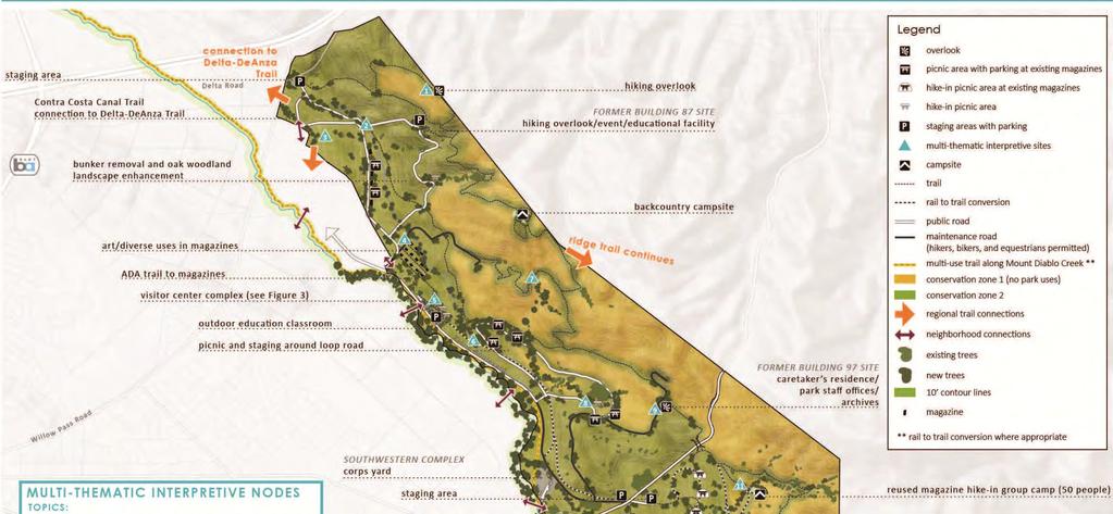

37 Alternative B- Interpretive Nodes xxx

38 Alternative B Increased Tree Planting Northern Area Public Loop Road to Educational/Event Facility Backcountry campsite
 No roads in Southern Area Emphasis on Rail-to-Trail Ridge Trail connects through adjacent property Group Camp Sites")
39 Alternative B Central and Southern Area Public Loop Road around Cistern Pond Area with picnic sites Staging Areas at Bailey Road (no Public Roads) No roads in Southern Area Emphasis on Rail-to-Trail Ridge Trail connects through adjacent property Group Camp Sites (2)
40 Alternative B xxx

41 Magazine Reuse

42 Magazine Reuse: Community Uses xxx
43 Questions?
44 Small Group Exercise 1. Introductions 2. Select facilitator, timekeeper, and note-taker 3. Select an Alternative to work from 4. Complete Activities #1, 2, and 3 5. Select spokesperson 6. Turn in Activity Board

45 Conclusions and Next Steps Photo by Stephen Joseph
46 Conclusions and Next Steps Opportunities for Public Input: Alternative Park Land Use Plans (Winter, 2016) Draft Park Land Use Plan (Spring, 2016) Environmental Review (Fall, 2016) Adoption of Final Land Use Plan (Late Fall, 2016) For Project Updates and to Share your Thoughts: Questions and Comments? Contact Brian Holt, Principal Planner, East Bay Regional Parks District
47 For project updates and opportunities to share your thoughts, go to: Questions or comments? Brian Holt, Principal Planner East Bay Regional Parks District
Concord Hills Regional Park Land Use Plan and EIR
 Concord Hills Regional Park Land Use Plan and EIR EBPRD/NPS Visioning Workshop August 11, 2015 10:00am-4:00pm Draft Meeting Summary OVERVIEW This workshop built upon a preliminary visioning meeting from
Project Team. 2M Associates. City of Saratoga. HT Harvey Biology. PlaceWorks. NV5 Infrastructure. Tom Origer Associates History/Archeology
 Project Team City of Saratoga John Cherbone, Director of Public Works Iveta Harvancik, Senior Engineer PlaceWorks Isabelle Minn, Principal-in-Charge Isby Fleischmann, Project Manager Kyle Simpson, CEQA
Saratoga Quarry Park Master Plan
 Project Team City of Saratoga John Cherbone, Director of Public Works Iveta Harvancik, Senior Engineer PlaceWorks Isabelle Minn, Principal-in-Charge Isby Fleischmann, Project Manager Kyle Simpson, CEQA
April 21, 2007 CCRP Workshop Summary
 April 21, 2007 CCRP Workshop Summary Group 1 1. Reuse around BART with a lot of housing and jobs 2. Greenway around creek 3. Transit and auto connection all through the site from Kirker Pass to Port Chicago
Fort Ord Regional Trails Planning
 Fort Ord Regional Trails Planning FORA Board July 11, 2014 Josh Metz, Associate Planner Overview Base Reuse Plan (BRP) trails planning context Trails planning in FORA jurisdictions and related entities
SCC PRD (2016) COUNTY PARK MASTER PLAN
 COUNTY PARK MASTER PLAN") SCC PRD (2016) COUNTY PARK MASTER PLAN MASTER PLAN UPDATE PARKS AND RECREATION COMMISSION NOVEMBER 7, 2018 PURPOSE OF THE MASTER PLAN The Sanborn County Park Master Plan will provide the Department with
SCC PRD (2016) COUNTY PARK MASTER PLAN MASTER PLAN UPDATE PARKS AND RECREATION COMMISSION NOVEMBER 7, 2018 PURPOSE OF THE MASTER PLAN The Sanborn County Park Master Plan will provide the Department with
Charles P. Johnson and Associates. Annapolis Landscape Architects
 Charles P. Johnson and Associates Annapolis Landscape Architects AGENDA Introduction Project Limits and Scope Site Analysis Opportunities & Constraints Program Goals Image Boards Design Alternatives Pros
DOMINION BOULEVARD CORRIDOR STUDY AND ECONOMIC DEVELOPMENT STRATEGIC PLAN A MODEL FOR CHESAPEAKE S FUTURE
 DOMINION BOULEVARD CORRIDOR STUDY AND ECONOMIC DEVELOPMENT STRATEGIC PLAN A MODEL FOR CHESAPEAKE S FUTURE Overview I. Draft Plan Process II. Draft Plan Overview a. Market Analysis b. Master Land Use Plan
(Exhibit A) Site Plan Adoption Detail and Support Information
 Site Plan Adoption Detail and Support Information") McCormick Park Master Site Plan (Exhibit A) Site Plan Adoption Detail and Support Information July, 2003 McCormick Park Site Plans.... 2-3 McCormick Park Site Plan Comparison... 4 Basic Assumptions about
McCormick Park Master Site Plan (Exhibit A) Site Plan Adoption Detail and Support Information July, 2003 McCormick Park Site Plans.... 2-3 McCormick Park Site Plan Comparison... 4 Basic Assumptions about
18 May 2016 CAMPUS MASTER PLAN UPATE
 18 May 2016 CAMPUS MASTER PLAN UPATE Council of the Deans ( Over view) AGENDA Engagement & What We Heard Focus Elements: 1. Development Framework Plan 2. Campus Mobility 3. Campus Guidelines 4. Wayfinding
Draft Cary Community Plan Review Part 3: Shop, Engage, Serve, Special Area Plans, Other Updates. October 27, 2015 Police Department Training Room
 Draft Cary Community Plan Review Part 3: Shop, Engage, Serve, Special Area Plans, Other Updates Committee for the Future October 27, 2015 Police Department Training Room AGENDA 1. Welcome and Call to Order
Task Force Meeting December 11, 2007
 Martial Cottle Park Master Plan with State Park General Plan Elements Task Force Meeting December 11, 2007 Agenda 1. Welcome and Introductions 2. Accept Task Force Meeting #1 Summary 3. Community Workshop
Design Alternatives Workshop. Hilfiker Park Master Plan Workshop #2
 Design Alternatives Workshop Hilfiker Park Master Plan Workshop #2 Agenda for Tonight Staff Presentation (40 min) Introduction Master Plan Process Planning Context What We ve Heard So Far Design Alternatives
Delaware River Waterfront Corporation
 Delaware River Waterfront Corporation Delaware River Waterfront Corporation Created in January 2009 to replace Penn s Landing Corporation o Open, accountable, effective leadership o New Board of Directors
INDEPENDENCE BOULEVARD AREA PLAN. June 24, 2008
 INDEPENDENCE BOULEVARD AREA PLAN Public Meeting #1 June 24, 2008 Tonight s Agenda Introduction Welcome and Ground Rules Overview Presentation Purpose of the Plan What Brings Us Here? A Tour of the Corridor
WEST OAKLAND SPECIFIC PLAN & DRAFT ENVIRONMENTAL IMPACT REPORT
 WEST OAKLAND SPECIFIC PLAN & DRAFT ENVIRONMENTAL IMPACT REPORT Landmarks Preservation Advisory Board Public Hearing February 10, 2014 1 Specific Plan Overview Plan Area is generally bounded by I-580 to
Danvers High Street I-1 District Study
 Danvers High Street I-1 District Study Presentation of Final Recommendations Planning Board Presentation June 26 th, 2018 1 Introductions Metropolitan Area Planning Council Sam Cleaves AICP, Principal
Tyvola & Archdale Transit Station Area Plan. May 15, 2008
 Tyvola & Archdale Transit Station Area Plan First Public Meeting May 15, 2008 Presentation Outline 1. Purpose and Process 2. Station Area Overview 3. Plan Recommendations Vision Land Use Transportation
CITY CLERK. Parkland Acquisition Strategic Directions Report (All Wards)
") CITY CLERK Clause embodied in Report No. 10 of the, as adopted by the Council of the City of Toronto at its meeting held on November 6, 7 and 8, 2001. 10 Parkland Acquisition Strategic Directions Report
CITY CLERK Clause embodied in Report No. 10 of the, as adopted by the Council of the City of Toronto at its meeting held on November 6, 7 and 8, 2001. 10 Parkland Acquisition Strategic Directions Report
Atlanta BeltLine. Subareas 9 & 10. Master Plan Updates. March 26, Washington Park Jamboree 1
 Atlanta BeltLine Subareas 9 & 10 Master Plan Updates March 26, 2018 Washington Park Jamboree 1 22 miles, connecting 45 neighborhoods 22 MILES of transit 46 MILES of streetscapes and complete streets 33
Maplewood Avenue Downtown Complete Street Project
 Maplewood Avenue Downtown Complete Street Project Second Public Meeting January 24, 2018 Welcome and Introduction of Project Team City Planning and Public Works Staff City of Portsmouth Juliet Walker Planning
W&OD PARK MASTER PLAN. The City s Greenest Street. DRAFT W&OD Trail Master Plan v4.docx Page 1
 W&OD PARK MASTER PLAN Adopted XXX-XX-XXXX The City s Greenest Street DRAFT W&OD Trail Master Plan v4.docx Page 1 Introduction and Purpose The Washington & Old Dominion Railroad Regional Park (W&OD) (which
Natomas Vision Plan and PLNP
 Natomas Vision Plan 20030171 and PLNP2014-00172 Department of Community Development Planning and Environmental Review Leighann Moffitt Sub-Agenda 1. Staff Presentation Leighann Moffitt, County Planning
2035 General Plan Update and Belmont Village Specific Plan. Joint Study Session with the City Council and Planning Commission April 12, 2016
 2035 General Plan Update and Belmont Village Specific Plan Joint Study with the City Council and Planning Commission April 12, 2016 Agenda 1. Welcome and Introductions 2. General Plan Update Status of
FORT MISSOULA REGIONAL PARK
 FORT MISSOULA REGIONAL PARK Master Plan Refinement/ Design Development www.missoulaparks.org DHM Design/WGM Group December 3, 2008 Master Plan Report Fort Missoula Regional Park Guiding Principals i 6/14/01
Summary Community Workshop #6 Beacon Day School Saturday, November 14, :00 a.m. 12:00 p.m.
 Summary Community Workshop #6 Beacon Day School Saturday, November 14, 2009 9:00 a.m. 12:00 p.m. Workshop Format and Process The City of Oakland is preparing a Specific Plan that will help define and determine
India Basin/Hunters Point Shoreline Community Workshop May 21, 2008
 India Basin/Hunters Point Shoreline Community Workshop May 21, 2008 Workshop Agenda Welcome Process Overview Context & Existing Conditions Presentation of Draft Concepts Land Use and Open Space Priorities
Albion Hills Conservation Area Master Plan. Public Information Session
 Albion Hills Conservation Area Master Plan Public Information Session 1 03.25.2014 Meeting Agenda 1. Project Introduction Property History Current Use Master Plan Process 2. Draft Vision Goals and Objectives
Don Mills Crossing Study and Celestica Lands Development Application Community Meeting, Open House, and Breakout Discussions
 Consultation Summary Don Mills Crossing Study and Celestica Lands Development Application Community Meeting, Open House, and Breakout Discussions This report is not intended to provide a verbatim transcript
Mendota Heights 2040 Comprehensive Plan Draft Vers
 4 Parks and Trails The City of Mendota Heights boasts a variety of recreational and open space opportunities. Few cities can claim access to regional trails, riverside and lakeside parks, scenic bluffs
Cobb County Design Guidelines Mableton Parkway & Veterans Memorial Highway Community Design Workshop January 12, 2017
 Community Design Workshop January 12, 2017 Agenda Opening Remarks / Introductions Scope of Work Existing Conditions Key Issues / Opportunities VPS Summary Draft Vision & Goal Statement Implementation Concepts
Mission Bay Park Master Plan Update: Fiesta Island Amendment (Information) Mission Bay Park Committee October 3, 2017
 Mission Bay Park Committee October 3, 2017") Mission Bay Park Master Plan Update: Fiesta Island Amendment (Information) Mission Bay Park Committee October 3, 2017 Tonight s Agenda Introduction & Project Overview Proposed Circulation Changes Overview
Mission Bay Park Master Plan Update: Fiesta Island Amendment (Information) Mission Bay Park Committee October 3, 2017 Tonight s Agenda Introduction & Project Overview Proposed Circulation Changes Overview
Scope of Services. River Oaks Boulevard (SH 183) Corridor Master Plan
 Corridor Master Plan") Scope of Services River Oaks Boulevard (SH 183) Corridor Master Plan PROJECT AREA The project area consists of the River Oaks Boulevard (SH 183) corridor bounded by SH 199 at the northern end and the Trinity
Scope of Services River Oaks Boulevard (SH 183) Corridor Master Plan PROJECT AREA The project area consists of the River Oaks Boulevard (SH 183) corridor bounded by SH 199 at the northern end and the Trinity
Welcome to the LYNX Blue Line Extension Transit Station Area Plans Public Workshop No. 3. Presentation will begin at 6:00 P.M.
 Welcome to the LYNX Blue Line Extension Transit Station Area Plans Public Workshop No. 3 Presentation will begin at 6:00 P.M. Meeting Agenda Blue Line Extension (BLE) Project Update LYNX Blue Line Extension
Public may provide comments on the GDP within the next two weeks (December 24)
") 25/70 General Development Plan (GDP) Public Meeting Wednesday, December 10, 2014 6:00 8:00 P.M. District 1 Police Station Community Room 1311 W 46th Ave, Denver, CO 80211 Council Woman Montero: This particular
25/70 General Development Plan (GDP) Public Meeting Wednesday, December 10, 2014 6:00 8:00 P.M. District 1 Police Station Community Room 1311 W 46th Ave, Denver, CO 80211 Council Woman Montero: This particular
Report to: Development Services Committee Report Date: April 24, 2017
 SUBJECT: Cornell Rouge National Urban Park Gateway - Report on Design Charrette and Next Steps PREPARED BY: Lilli Duoba, MES, MCIP, RPP, Manager, Natural Heritage (ext. 7925) REVIEWED BY: Marg Wouters,
Whitemarsh Comprehensive Plan Update: Housing & Land Use. Public Workshop #3: September 20, 2018
 Whitemarsh Comprehensive Plan Update: Housing & Land Use Public Workshop #3: September 20, 2018 Agenda Welcome Process Recap What We ve Heard The Plan Framework Review of Recommended Actions Land Use Housing
THE GARDEN CITY PLAN. City of St. Catharines Official Plan. City of St. Catharines
 THE GARDEN CITY PLAN City of St. Catharines Official Plan City of St. Catharines August 2010 APPROVAL INFORMATION This Official Plan of the City of St. Catharines Planning Area, known as the Garden City
City of Nogales General Plan
 Open Space, Parks, Recreation and Trails City of Nogales General Plan Residents of Nogales place a high priority in the development of a comprehensive system of open space, parks, recreation and trails
Potential Green Infrastructure Strategies May 6, 2015 Workshop
 Potential Green Infrastructure Strategies May 6, 2015 Workshop Background The City of Cortland is developing the Tioughnioga Urban Headwaters Green Infrastructure Action Plan with funding from the National
South of Eastern Strategic Direction Status Update
 STAFF REPORT ACTION REQUIRED South of Eastern Strategic Direction Status Update Date: July 10, 2014 To: From: Planning and Growth Management Committee Chief Planner and Executive Director, City Planning
U T D N o r t h C a m p u s T O D and D o w n t o w n D e n t o n T O D
 U n i v e r s i t y o f T e x a s a t D a l l a s C i t y o f R i c h a r d s o n U T D N o r t h C a m p u s T O D and D o w n t o w n D e n t o n T O D Rick Leisner, AICP Assistant Director of Development
PG&E WINTERS GAS OPERATIONS AND TECHNICAL TRAINING CENTER
 PG&E WINTERS GAS OPERATIONS AND TECHNICAL TRAINING CENTER CEQA scoping Meeting March 19 th, 2014 Winters City Council Chambers - 6:30 pm AGENDA FOR THE MEETING 6:30 Welcome (John Donlevy) 6:40 Overview
HUMBER BAY PARK PROJECT - BUILDING CONCEPT
 WELCOME 1 Humber Bay Park, with its system of trails, rugged shoreline, and dramatic views, is a unique and rare waterfront experience within the larger metropolitan Toronto area offering a place for quiet,
Remi Mendoza City Planning Academy March 13, 2017
 Remi Mendoza City Planning Academy March 13, 2017 1 What is the General Plan? The 2030 General Plan 5-Year Update (2035 General Plan) Questions and Answers 2 Guidebook for development and growth Required
Call for Artists for: Design and Construction of Environmental Art Activation Story Mill Community Park, Bozeman, MT
 Call for Artists for: Design and Construction of Environmental Art Activation Story Mill Community Park, Bozeman, MT Seeking artists to design, fabricate and install art elements in the nature sanctuary
Tyvola & Archdale Transit Station Area Plan. June 5, 2008
 Tyvola & Archdale Transit Station Area Plan Second Public Meeting June 5, 2008 Presentation Outline 1. Purpose and Process 2. Station Area Overview 3. Plan Recommendations 4. Comments Received and Proposed
CHAPPLES PARK MASTER PLAN
 CHAPPLES PARK MASTER PLAN Presentation of Preliminary Development Options Public Open House #2 Wednesday November 2 nd, 2016 TONIGHT S AGENDA 1. Welcome & Introductions 2. Presentation by Sierra Planning
Subject: 30 Otis Street, Evaluation of Shadow on Proposed 11th and Natoma Park
 Date: September 5, 2018 To: Recreation and Park Commission Capital Committee Through: Philip A. Ginsburg, General Manager Toks Ajike, Director, Capital & Planning Division From: Brian Stokle, Planner,
City of Grande Prairie Development Services Department KENNEDY DEVELOPMENTS LTD. OUTLINE PLAN OP-09-01
 City of Grande Prairie Development Services Department KENNEDY DEVELOPMENTS LTD. OUTLINE PLAN OP-09-01 July 27, 2009 TABLE OF CONTENTS 1.0 Introduction... 1 1.1 Plan Area Location & Context... 1 1.2 Ownership
AN INNOVATIVE GREEN REDEVELOPMENT APPROACH. Bruce Greer, P.E. Manager, Environmental Services
 AN INNOVATIVE GREEN REDEVELOPMENT APPROACH Bruce Greer, P.E. Manager, Environmental Services Joseph Shefchek, M.S. Chief Environmental Officer Alliant Energy Corporation www.alliant-energy.com Sonya Newenhouse,
ADOPTION OF THE REVISED OPEN SPACE AND CONSERVATION ELEMENT OF THE GENERAL PLAN
 TO: FROM: SUBJECT: Honorable Mayor and City Council Planning Department ADOPTION OF THE REVISED OPEN SPACE AND CONSERVATION ELEMENT OF THE GENERAL PLAN RECOMMENDATION: It is recommended that the City Council:
Gold Line Bus Rapid Transit Transit Oriented Development (BRTOD) Helmo Station Area Plan
 Helmo Station Area Plan") Appendix F Gold Line Bus Rapid Transit Transit Oriented Development (BRTOD) Helmo Station Area Plan Introduction and Purpose of the Plan The Gold Line Bus Rapid Transit facility is an eleven-mile dedicated
Appendix F Gold Line Bus Rapid Transit Transit Oriented Development (BRTOD) Helmo Station Area Plan Introduction and Purpose of the Plan The Gold Line Bus Rapid Transit facility is an eleven-mile dedicated
BURTON STATION STRATEGIC GROWTH AREA PLAN UPDATE PUBLIC MEETING 3/26/18
 BURTON STATION STRATEGIC GROWTH AREA PLAN UPDATE PUBLIC MEETING 3/26/18 1 WHERE WE ARE? 2 PRIMARY OBJECTIVES OF THE PLAN UPDATE 1. Update the land use designation for Burton Station Village to reflect
Edgeley Pond + Park Public Meeting
 Edgeley Pond + Park Public Meeting February 21, 2017 Purpose of the meeting This Public Meeting is an opportunity for you to review the project background, process and provide input. City of Vaughan staff
BISCUIT RUN PARK MASTER PLAN
 BOARD OF SUPERVISORS November 14, 2018 BISCUIT RUN PARK MASTER PLAN COUNTY OF ALBEMARLE ANHOLD ASSOCIATES Contents Project Introduction Property Background County Park Planning Process Existing Site &
CHAPTER 1 Introduction
 CHAPTER 1 Introduction From sea to summit, Lane County covers almost 4,800 square miles of diverse Oregon landscape. Stretching from the Pacific Ocean through the Coastal Range, the Willamette Valley to
IMPLEMENTING SOMERSET COUNTY S INVESTMENT FRAMEWORK
 IMPLEMENTING SOMERSET COUNTY S INVESTMENT FRAMEWORK SMART CONSERVATION THROUGH SMART GROWTH NJ LAND CONSERVATION RALLY March 22, 2014 Laurette Kratina, PP, AICP, Supervising Planner Somerset County Planning
Agenda. 3. Outstanding Items. How it would work (DRP) Urban Design Guidelines language in Sector Plan (Concepts) vs. Guidelines Document (Detail)
 Urban Design Guidelines language in Sector Plan (Concepts) vs. Guidelines Document (Detail)") Work Session #14 Planning Board June 9, 2016 Agenda 1. Big Picture Items to Confirm Upfront 2. Detailed Topics for Conversation a) Park Impact Payment b) Priority Sending Sites - Additional Incentives
Work Session #14 Planning Board June 9, 2016 Agenda 1. Big Picture Items to Confirm Upfront 2. Detailed Topics for Conversation a) Park Impact Payment b) Priority Sending Sites - Additional Incentives
Review of Opportunity Area C Draft Comprehensive Plan and Draft BOS Follow-On Motions. Special Working Group Meeting March 4, 2015
 Review of Opportunity Area C Draft Comprehensive Plan and Draft BOS Follow-On Motions Special Working Group Meeting March 4, 2015 The slides that follow identify where the draft Comprehensive Plan has
Northwest LRT Downtown to. Northwest Edmonton Study. Public Workshops
 Northwest LRT Downtown to Northwest Edmonton Study Public Workshops March 23 & 24, 2010 Welcome Thank you all for attending Welcome Introductions Welcome Our Team s Commitment to You for Tonight To provide
MEETING PURPOSE AND OVERVIEW
 MEETING PURPOSE AND OVERVIEW On February 23, 2012, the City of Elk Grove hosted the first of two community workshops related to the Southeast Policy Area. The workshop was held from 6:00 8:30 p.m. in the
Community Engagement Committee Meeting #1 December 10, :30pm-8:30pm
 Community Engagement Committee Meeting #1 December 10, 2014 6:30pm-8:30pm Welcome and Introductions Dana Murdoch Minneapolis Park and Recreation Board Project Manager Ryan French Walker Art Center Director
UPDATE ON THE INDEPENDENCE BOULEVARD AREA PLAN. Citizen Advisory Group Meeting March 3, 2011
 UPDATE ON THE INDEPENDENCE BOULEVARD AREA PLAN Citizen Advisory Group Meeting March 3, 2011 Purpose: Why are we here? To provide an update on the Independence Boulevard Area Plan 1. Overview of the ULI
PUBLIC ENGAGEMENT & SIX THEMES OF THE PLAN
 Connecting the heart of Eagle to the soul of the river - Kathy Chandler-Henry, Commissioner Eagle County CHAPTER 1 PUBLIC ENGAGEMENT & SIX THEMES OF THE PLAN town of eagle - river corridor plan 1 PUBLIC
Clarksburg Master Plan Concept and the Clarksburg Town Center. Planning Regulating Building
 Master Plan Concept and the Town Center Planning Regulating Building Overview with CTC PHED T&E Dec 12, 2011 outline Location Master Plan Concept Staging Approved Preliminary Plans Infrastructure Town
Southward Community Recreation and Sports Park Southward Community Recreation and Sports Park Concept Design Images and Information.
 Concept Design Images and Information Please note that this information is concept only at this point. These are not engineered drawings and the project has not yet gone to tender. The intention of this
CHAPTER 1. Ms. Guajardo s Class - Central Elementary CH 1 1
 INTRODUCTION CHAPTER 1 Ms. Guajardo s Class - Central Elementary CH 1 1 1.1 SETTING South Centre City is a linear corridor south of Downtown Escondido paralleling Centre City Parkway and South Escondido
Las Colonias Park Master Plan
 2013 Las Colonias Park Master Plan City of Grand Junction June 2013 Introduction Las Colonias Park, a 101 acre parcel on the edge of the Colorado River south of downtown, was deeded to the City of Grand
Isabel Neighborhood Plan: Alternatives
 Isabel Neighborhood Plan: Alternatives Presented by: Lori Parks, Associate Planner February 2, 2015 Agenda 1. Background on BART to Livermore 2. Isabel Neighborhood Plan 3. Alternative Scenarios 4. General
Martin Pastucha, Director of Public Works Karen Ginsberg, Director of Community and Cultural Services
 Information Item Date: August 11, 2015 To: From: Subject: Mayor and City Council Martin Pastucha, Director of Public Works Karen Ginsberg, Director of Community and Cultural Services Reed Park Improvement
CAMPUS MASTER PLAN UPATE
 19 MAY 2016 CAMPUS MASTER PLAN UPATE Metropolitan Planning Organization AGENDA Introductions Planning Scope Observation & Analysis: Mobility Systems Campus Development Plan Mobility Planning Scenarios
Arkansas River Corridor
 Planning for Access Welcome to the Access Project. This project is a recreational planning effort in response to an interest by regional communities along the Arkansas River corridor. The project plan
8implementation. strategies
 PROGRAM STRATEGIES 8implementation strategies T he implementation actions of this chapter are designed to support and carry out the land use, economic development, transportation, urban design, and program
WELCOME TO THE CHOUTEAU GREENWAY DESIGN, DEVELOPMENT AND CONSTRUCTION WORKING GROUP!
 WELCOME TO THE CHOUTEAU GREENWAY DESIGN, DEVELOPMENT AND CONSTRUCTION WORKING GROUP! Chouteau Greenway Steering Committee and Working Groups Overview Overview January 9, 2019 Chouteau Greenway will transform
Atlanta BeltLine, Inc. Pathways to Urban Sustainability
 Atlanta BeltLine, Inc. Pathways to Urban Sustainability September 30, 2010 WHAT IS THE ATLANTA BELTLINE? Transit 22-mile loop Parks 1300 + new acres Trails 33 miles Jobs & Economic Development 20 areas,
Community Meeting #2.1
 Community Meeting #2.1 Thursday, October 20, 2016, 7:00 p.m. to 9:00 p.m. Eliot Elementary School, 475 Old Gilroy Street, Gilroy, CA 95020 Meeting Summary The City of Gilroy held its third community meeting
Ivywild On The Creek PRELIMINARY CREEK DISTRICT MASTER PLAN
 Ivywild On The Creek PRELIMINARY CREEK DISTRICT MASTER PLAN Introduction: Rejuvenating an extraordinary Creekside neighborhood THE CREEKSIDE DISTRICT The Ivywild On The Creek Neighborhood District Master
Visioning Committee Kick-Off Meeting
 Visioning Committee Kick-Off Meeting June 11, 2018 The Team Project management, technical analysis, implementation, report preparation Public engagement, park review Recreation facilities review, operations
BROOKHILL NEIGHBORHOOD MODEL ZONING MAP AMENDMENT PREFACE TO APPLICATION
 BROOKHILL NEIGHBORHOOD MODEL ZONING MAP AMENDMENT PREFACE TO APPLICATION June 15, 2015 Revised: August 1, 2016 I. VISION Brookhill is a proposed community based upon the principles of Albemarle County
Phase I Redevelopment Plan. First Community Meeting
 Hoboken Terminal and Yard Phase I Redevelopment Plan First Community Meeting May 31, 2011 One Hudson Place Phase I Redevelopment Plan Redevelopment Plan First Community Meeting Agenda 1. Redevelopment
Crofton Manor 2803 West 41st Avenue WHAT WE HEARD. Public Consultation: Phase 1
 Crofton Manor 2803 West 41st Avenue WHAT WE HEARD Public Consultation: Phase 1 Background CROFTON MANOR What s Happening The City of Vancouver is undertaking a planning and public engagement process to
1 October Dear Citizens of Charlotte and Mecklenburg County,
 1 October 2011 Dear Citizens of Charlotte and Mecklenburg County, As co-chairs of the Center City 2020 Vision Plan Steering Committee, we are proud to present the Center City 2020 Vision Plan, which sets
Welcome. Walk Around. Talk to Us. Write Down Your Comments
 Welcome This is an information meeting introducing the applications for proposed redevelopment of the Yorkdale Shopping Centre site at 3401 Dufferin Street and 1 Yorkdale Road over the next 20+ years,
SF RECREATION & PARK DEPARTMENT URBAN TRAILS PROGRAM
 SF RECREATION & PARK DEPARTMENT URBAN TRAILS PROGRAM TRAIL IMPROVEMENTS October 5, 2011 TRAIL IMPROVEMENTS 6:30 8:00 p.m. AGENDA WELCOME & INTRODUCTION URBAN TRAILS PROGRAM OVERVIEW TRAIL IMPROVEMENTS
Daniels Park Master Plan
 Daniels Park Master Plan Prepared for: Douglas County & The City and County of Denver October, 2007 EXHIBIT A Contents Daniels Park Overview 2 Project History & Goals 2-3 Regional Context Map 4 Park Zone
MAYFIELD VILLAGE GREENWAY TRAIL
 1 Shared use 10 wide asphalt all purpose trail Includes 60 ft. steel truss bridge, 549 ft. of boardwalk, three underpasses Connects Village center to Library, Metroparks, and Village recreational areas
Secrest Short Cut and Monroe Expressway Small Area Plan AUGUST 29, 2018
 Secrest Short Cut and Monroe Expressway Small Area Plan AUGUST 29, 2018 Background and Process Monroe Expressway will be open by the end of 2018 Union County and Indian Trail identified a need to revisit
DRAFT PLAN PRESENTATION
 DRAFT PLAN PRESENTATION 1.23.2018 AGENDA Process Project Schedule Results from Visioning Workshop Draft Plan Highlights Concept Plans Feedback Next Steps PROJECT SCHEDULE KICK-OFF WORKSHOP August 29 th
Niagara National Heritage Area
 Niagara National Heritage Area What is a National Heritage Area? It is a regional place where natural, cultural, historic and recreational resources combine to form a nationally distinctive landscape and
CITY of NOVI CITY COUNCIL
 CITY of NOVI CITY COUNCIL Agenda Item P November 23, 2015 SUBJECT: Approval to expand the scope of the Master Plan for La nd Use Contract to include a study of entire Grand River Avenue corridor, including
LINCOLN COUNTY COMMONS - REVISED MASTER PLAN. Lincoln County Public Meetings June 26-27, 2018, 6pm
 LINCOLN COUNTY COMMONS - REVISED MASTER PLAN Lincoln County Public Meetings June 26-27, 2018, 6pm PROJECT OVERVIEW Lincoln County is preparing a Refined Master Plan for facilities at the Lincoln County
Green System Planning Day 4 SALA Vancouver Summer Program
 Green System Planning Day 4 SALA Vancouver Summer Program OUTLINE 1. Lecture 1 Green Networks Cynthia Girling 2. Break 3. Lecture 2 Principles of Park Planning Jeff Fitzpatrick 4. Photo of the Day assignment
Subarea 4 Indian Creek. Vision The combination of park networks and transportation amenities make Subarea 4 the greenest hub in the Corridor.
 indian creek 180 extends south from 101st Street to I-435. The I-435 and Metcalf intersection is one of the primary intersections in the Kansas City Metro Area. The area includes several residential neighborhoods
The transportation system in a community is an
 7 TRANSPORTATION The transportation system in a community is an important factor contributing to the quality of life of the residents. Without a sound transportation system to bring both goods and patrons
Por favor, levanten la mano si necesita traduccion en espanol Please raise your hand if you need Spanish translation
 FEDERAL BOULEVARD CORRIDOR WIDE STUDY PUBLIC MEETING #1 APRIL 27, 2016 Por favor, levanten la mano si necesita traduccion en espanol Please raise your hand if you need Spanish translation HDR DESIGN WORKSHOP
CAMPUS PLACEMAKING: CAC WORK SESSION. August 23, 2018
 CAMPUS PLACEMAKING: CAC WORK SESSION August 23, 2018 AGENDA Public Realm Framework Overview & Discussion (~20 minutes) Health & Wellness Report Overview & Discussion (~15 minutes) Riverfront Update & Discussion
2 STATUTORY PUBLIC MEETING AND INFORMATION REPORT FOR PUBLIC MEETING ON AMENDMENT NO. 62 TO THE YORK REGION OFFICIAL PLAN
 2 STATUTORY PUBLIC MEETING AND INFORMATION REPORT FOR PUBLIC MEETING ON AMENDMENT NO. 62 TO THE YORK REGION OFFICIAL PLAN Pursuant to Section 17(15) of the Planning Act, as amended, the Regional Planning
Vision & Land Use. Discussion. Historic Preservation Plan. Foggy Bottom Campus Plan:
 Vision & Land Use Foggy Bottom Campus Plan: 2006-2025 Historic Preservation Plan Discussion Community Meeting Presentation August 2, 2006 Presentation Format Overview Sherry Rutherford, GW Foggy Bottom
Pittsburg/Bay Point BART Master Plan
 Pittsburg/Bay Point BART Master Plan Workshop #1 June 24, 2009 Workshop Agenda Sign-in and Introductions What is a Master Plan and how does it affect me? Existing Conditions and Project Information Strengths