Joint Meeting City Council and the Plan Commission. September 1st, 2015
|
|
|
- Hilda Williamson
- 5 years ago
- Views:
Transcription
1 Joint Meeting City Council and the Plan Commission September 1st,

2 The City Plan Commission shall recommend a City Plan for the physical development of the City Article IX Section 2 of the City of Waco Charter 2
3 Comprehensive Plan History 1958 Inner-City Redevelopment 1967 A New Image for Waco 1983 Improving the Quality of Development 2000 Preserve and Improve the Quality of Life Recently ( ) Imagine Waco: A Plan for Greater Downtown Near North Side Master Plan Future Land Use for McLennan County Community Visioning Project Economic Development Plan-Upjohn Plan Thoroughfare Plan Waco Metropolitan Area Downtown Transportation Plan 3
4 Sustainable Development Sustainable Development Development that meets the needs of the present without compromising the ability of future generations to meet their own needs. Sustainability addresses the following issues: More efficient use of increasingly scarce resources Fiscal Sustainability Healthier and safer communities Protection of the environment Preservation of open space Improved mobility Shared benefits 4
5 Initial Citizen Participation Fall Staff conducted 4 standard public input meetings at various locations around Waco. Conducted continuous online public input process consisting of: Surveys Questionnaires Interactive maps Citizen idea submission Photo surveys 5
6 Issues 1. Poverty reduction 2. Workforce development 3. Targeted job creation 4. Employment accessibility 5. Neighborhood diversity 6. Public health 7. Education 8. Downtown/Riverfront development 9. Neighborhood revitalization 10. Resource conservation 11. Open space preservation 12. Flood plain and wetlands protection 13. Historic preservation 14. Urban sprawl prevention 15. Optimum mobility 6
7 Components of the Comprehensive Plan Goals and Objectives Economic Development Growth Management Transportation Utilities Housing Livability Environment Implementation 7
8 Economic Development 8

9 Percent of City Population Living Up to 200% of Poverty, (excludes students) 9
10 Metropolitan Waco Commuting Patterns Employed Residents 42,535 Living and Working in the City 22,017 City Employment 67,017 10
11 Recommendations Bring Jobs to City Residents Encourage manufacturers to locate in the inner city, which would directly alleviate the transportation barrier faced by many residents The parcel could also be located near existing daycare centers, resolving another key barrier The development would improve the city s tax base 11

12 Map 2.3: Potential Employment Centers and Persons Living Below Census Defined Poverty Level 12
13 Growth Management 13
14 City of Waco and Extraterritorial Jurisdiction Change in Developed Uses: 1995 to

15 Location of Acreage Developed Since 1995 by Jurisdiction* *Within McLennan County 15
16 70.0% 65.0% 60.0% 55.0% Change in Percentage of County Population: 1970 to % 45.0% City of Waco Outside of Waco 40.0% 35.0% 30.0%

17 McLennan County Independent School District Boundaries 17

18 Projected Population Change: 2010 to 2040 Trend Scenario Traffic Analysis Zones 18
19 Projected Population Change: 2010 to 2040 City Plan Adopted Scenario Traffic Analysis Zones 19
20 Major Issues Addressed by the Land Use Plan Poverty Aging / Inadequate Infrastructure Suburban / Exurban growth Increasing demand for city services Declining resources 20
21 Land Use Plan Categories Rural Residential Low Density, Low Impact Development Focus on Open Space Preservation Density bonuses for Cluster Development Low Density Residential Single-Family Residential Varying lot sizes up to 10 units per acre Limited compatible uses providing services Medium Density Residential Office Flex Mix of residential types Limited office & neighborhood commercial 21 Walkable scale, support public transit
22 Land Use Plan Categories Office Industrial Flex Mix of compatible office, commercial & light industrial uses Limited high density residential Jobs to People Mixed Use Flex Mix of retail, office & high density residential Walkable scale, support public transit Mixed Use Core City Center Mix of very high density residential with office and supportive retail Highly walkable Preservation of historic structures & adaptive reuse 22
23 Land Use Plan Categories Industrial Nuisance-free industrial uses & compatible commercial or office Institutional Educational and medical facilities located on large campuses. Open Space Parks & Recreational Areas Flood zone risk areas 23
24 Land Use Location Considerations Existing Development vs. Vacant Land Flood Plain / Escarpment Existing & Proposed Transportation Arterial & Freeway Thoroughfares Bicycle & Pedestrian Transit Routes Utilities Existing & Proposed Access Employment Centers Childcare Healthcare Recreation 24
25 Map 3.4: Land Use Plan Designations Within Waco Corporate Limits 25

26 Land Use Plan Designations Waco Extraterritorial Jurisdiction 26
27 Development Nodes Purpose Focus areas for new future residential & employment Mix of commercial, office, medium density residential Scale of each node intended to be walkable & bicycle friendly Future population and employment density at a level which supports public transit 27
28 Development Nodes General Location Criteria Mix of Urban & Suburban environments Geographical dispersed Representative of a range of demographics Basic infrastructure and services exist or in close proximity 28

29 Proposed Development Nodes 30
30 2013 Land Use within Downtown Development Node Right of Way, 26.6% Other Developed, 15.8% Residential, 3.1% Commercial & Office, 14.7% Park, 4.1% Vacant, 23.4% Industrial, 8.0% 31
31 2013 Land Use within South Bosque Development Node Other Developed, 0.7% Other Undeveloped, 0.7% Agriculture, 42.6% Residential, 29.4% Right of Way, 21.4% Park, 0.0% Vacant, 2.3% Commercial & Office, 0.9% Industrial, 0.3% 32
32 100.0 Walkability Index by Development Node Current Short-Term Goal Long-Term Goal
33 Growth Areas Purpose Ensure that future growth patterns reinforce guiding principles, goals & objectives of the Plan Sustainability Identify priorities for future population and growth Serve as a guide for the provision of infrastructure and city services Contribute to the drafting of the City s Capital Improvements Program and Budget 35
34 Growth Area Recommendations 36
35 Growth Management Recommendation Encourage Sustainable Development Practices Changes to zoning & subdivision ordinance Provide flexibility in design and plan conformity bonuses Cluster Development Preservation of Open Space & Rural Uses Residential density provided through clustering of developments Consider Adoption of Impact Fees New development pays for costs associated with expansion of public infrastructure One-time charge applied to new development 37
36 Growth Management Recommendation Expand the use of Public Improvement Districts and Tax Increment Financing Revise Design Criteria for Economic Incentives Insure development contributes to long term stability of neighborhoods Consider Adoption of Stormwater Utility Fee 38
37 Growth Management Recommendation Develop Capital Improvements Programs that support achievement of the goals and objectives of The City Plan Adopt set of weighted criteria to give priority to sustainable projects Utilize whole life costing Revise Annexation Policy Advance Coordination with Property Owners Development of Service Plan for Infrastructure and Service Extensions Evaluate Fiscal Impact 39
38 Transportation 40
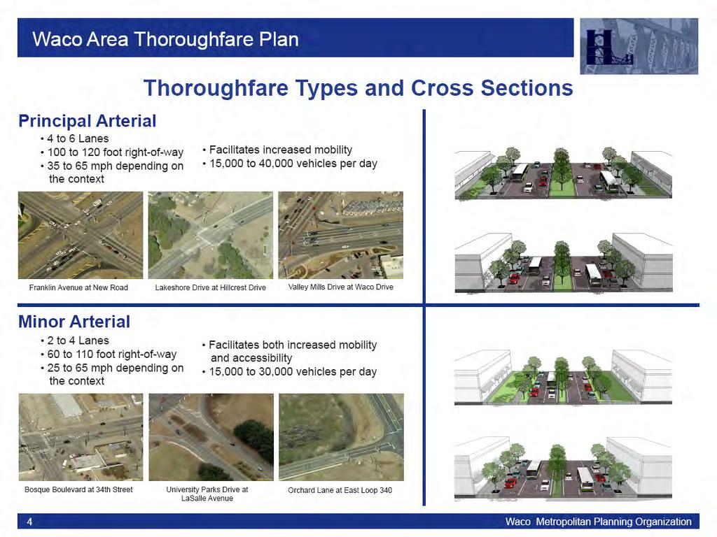
39 Thoroughfare Plan Adopted in 2013 Identify future thoroughfare corridors Location, alignment and function Identify appropriate design characteristics Context Sensitive Solutions Design recommendations vary by neighborhood context 41
40 42

41 Waco Regional Thoroughfare Plan Thoroughfare Classifications & Area Types Waco Urbanized Area 43
42 Selected Bicycle & Pedestrian Design Elements Strategy City Center Urban Suburban Rural Sidewalks on both sides of the Street Median Refuge Areas Reduced Corner Radius Desirable Desirable Desirable May be Appropriate Appropriate Appropriate Appropriate Not Appropriate Desirable Appropriate May be Appropriate Not Appropriate Bicycle Lanes Desirable Desirable Appropriate May be Appropriate Paved Shoulders Bicycle Parking Not Appropriate Not Appropriate May be Appropriate Desirable Desirable May be Appropriate Desirable May be Appropriate 44
43 Metropolitan Transportation Plan (MTP) Identify regional transportation goals Identify projects to be constructed or implemented by 2040 Projects that help achieve plan goals Includes regionally significant projects from each mode Highways, Public Transportation, Aviation, Rail Inclusion required for federally funded highway & transit projects Projects must be constrained against a realistic estimate of future revenues 45
44 MTP Primary Challenges 1. Further dispersion of population and employment to suburban and rural areas 2. Concentration of poverty within urban core 3. Limited financial resources 4. Air Quality 46
45 McLennan County Percent of Workers with Travel Times greater than 60 Minutes by Mode 30.0% 25.0% 20.0% 15.0% 10.0% 5.0% 0.0% Drove Alone Carpool Public Transportation Walked Other Total All Modes Source: US Dept of Commerce; Bureau of the Census American Community Survey 2008 to
46 MTP Draft Project Recommendations Strategy 1: Strategic Highway Expansions Top Priority: IH-35 reconstruction through Waco Strategy 2: Maintain Existing Infrastructure in State of Good Repair Strategy 3: Improve Connectivity to Essential Services Realignment of Waco Transit System Strategy 4: Reduce Transportation Related Injuries and Fatalities Strategy 5: Maximize System Efficiency Strategy 6: Improve Regional Livability 48

47 Map 8.2: Conceptual Realignment of Waco Transit Fixed Route System 49
48 Map 4.2: Regionally Significant Highway Projects 50

49 Map 8.6: Strategy 6: Regional Livability Priority Corridors Bicycle Facilities 51

50 Map 8.6: Strategy 6: Regional Livability Priority Corridors Pedestrian Facilities 52
51 Other Transportation Priorities Pavement Management System Traffic Signals Expanded Bicycle & Pedestrian Networks Passenger Rail Downtown Depot Transit Oriented Development 53
52 Utilities 54
53 Utility Infrastructure Same balanced population growth projections as other plan sections Evaluation of impact to future water supply Consistency with growth management recommendations Focus on improvements to existing infrastructure 55
54 Water CIP Projects by Type & Estimated Cost Renewal, $34,441, Plan, $82,486, Plan, $122,847, Plan, $47,340,200 56

55 Wastewater CIP Projects by Type & Estimated Cost Rehabilitation WMARSS $4,632, % Gravity Sewer / Force Main $54,240, % Asset Renewal $112,272, % WMARSS $53,928, % Lift Station $14,928, % TOTAL: $240,000,000 57
56 Map 5.1: Proposed Water Utility Improvements 58
57 Map 5.2: Proposed Wastewater Utility Improvements 59
58 Stormwater 2003 Plan identified $35 million in projects Plan never implemented Severe drought since 2009 No funding source or revenue stream Recommend establishment of stormwater utility fee 60
59 Stormwater Capital Costs from 2003 Plan Regional Detention $17,067,031 47% Planning $2,548,300 7% Conveyance $14,332,679 40% Buyouts $1,993,548 6% 61
60 Housing 62
61 Neighborhood & Housing Context Neighborhood One of the most important considerations in selecting a place to live More than a sum of structures. Defined by a sense of community and livability enjoyed by its residents Housing and Neighborhood Development are inextricably connected 63
62 2500 Total Lots vs. Built Lots: 1994 to 2011 City of Waco 2000 Number of Lots Houses Built Available Lots Highway 84 Corridor China Spring West Waco Remainder of Waco 64

63 Residential Subdivisions Submitted Since 1994 City of Waco and Extraterritorial Jurisdiction 65
64 Total Residential Building Permits 2007 to 2014 by Census Tract 66
65 Vacant Property Available for Development
66 Residential Structures Tagged for Repairs
67 65.0% Percent Owner-Occupied Housing Units City of Waco: 1970 to Present 60.0% 55.0% 50.0% 45.0% 40.0%
68 $1,700 Median Mortgage Costs & Gross Rent: 2009 to 2013 Average $1,500 $1,300 $1,100 $900 Gross Rent Mortgage $700 $500 Waco McLennan County State of Texas United States Peer City Average Peer County Average 70
69 45.0% Housing Costs as a Percent of Household Income: 2009 to 2013 Average 40.0% 35.0% 30.0% Owner Occupied Renter Occupied 25.0% 20.0% Waco McLennan County State of Texas United States Peer City Average Peer County Average 71
70 Housing Cost Burden Households spending greater than 30% of income on housing 35.1% of all Waco households 48.1% of moderate income ($56,188) 73.8% of low income ($41,600) 70.3% of extremely low income ($15,600) Total of 14,600 low to moderate income households 72
71 Single Family Housing Units Constructed or Rehabilitated by Non-Profits 73
72 Proposed Strategies Neighborhood Preservation Maintain & Restore / Rehab Restore / Rehab & Redevelop Development & Redevelopment Guidance Urban Core District 74
73 Proposed Residential Strategy Areas 75
74 Housing Recommendations Amend the land use plan and zoning ordinance to encourage more mixed use development Strengthen building code and zoning ordinance enforcement Implement a periodic inspection program for residential rental properties Adopt guidelines for the sale of tax foreclosed and City owned properties Consider using Public Improvement Districts or Reinvestment Zones to stabilize neighborhoods 76
75 Livability 77
76 Livability Livability is the sum of the factors that add up to a community s quality of life: including the built and natural environments; economic prosperity; health and safety; social stability; educational opportunity; and cultural, entertainment and recreational possibilities. - Partners for Livable Communities 78
77 Livability Categories Parks and Recreation Urban Design Streetscape & Walkability Connectivity Building Form Historic Preservation Preservation of Rural Character Arts & Culture Public Health 79
78 Environment 80
79 Environment Categories Climate Low Impact Development Water Conservation & Quality Energy Conservation Air Quality Waste Management 81
80 Air Quality Waco enjoys good air quality Region is has been close to maximum allowable levels of ozone High ozone levels are a known threat to human health EPA has proposed implementation of new lower ozone standards Metro Areas violating EPA standards are required to identify strategies to return to compliance 82
81 76 Waco 8-hour Ozone Design Values: 2007 to 2014 Parts per Billion Year Design Value Current EPA Standard Discussed Standard * 3 year Reporting Periods 83
82 Implementation Recommendations Plan Commission continue as the advisory committee for the Plan and implementation. Plan be updated every 5 years. Annual implementation report with priorities. Future planning effort should be consistent with the Comprehensive Plan Implementation efforts should go through a vigorous public involvement period. 84
83 Implementation All zoning, subdivision, development and CIP decisions should be evaluated for conformance of the Plan. Overhaul of zoning, subdivision and development ordinances needed Creation of a CIP scoring matrix based on the Plan 85
84 Draft Plan available Next Steps Public Comment Period during Sept. and October Neighborhood Meetings Public Meetings Sept. 24 th, 28 th & 29 th Plan Commission Action in October City Council Action in November 86
Implementation Guide Comprehensive Plan City of Allen
 Implementation Guide 2030 Comprehensive Plan City of Allen DRAFT 2015 Implementation Guide Allen 2030 Comprehensive Plan INTRODUCTION The Comprehensive Plan serves as a guide for the growth and development
CHAPTER 12 IMPLEMENTATION
 CHAPTER 12 IMPLEMENTATION The 2010 Town of Denton Comprehensive Plan is intended to capture a vision of the future of Denton. As such, it provides a basis for a wide variety of public and private actions
A BLUEPRINT FOR BROCKTON A CITY-WIDE COMPREHENSIVE PLAN
 A BLUEPRINT FOR BROCKTON A CITY-WIDE COMPREHENSIVE PLAN Public Meeting October 2016 1 Plan Summary and Discussion Public Meeting May 4 2017 City of Brockton Bill Carpenter, Mayor Department of Planning
The transportation system in a community is an
 7 TRANSPORTATION The transportation system in a community is an important factor contributing to the quality of life of the residents. Without a sound transportation system to bring both goods and patrons
Cumberland Region Tomorrow is a private, non-profit, citizen based regional organization working with Greater Nashville Regional Council
 Cumberland Region Tomorrow is a private, non-profit, citizen based regional organization working with Greater Nashville Regional Council and others in the public and private sectors, dedicated to planning
ITEM #8. Regional Smart Growth Program. Regional Smart Growth Program. Presentation Overview. Coast Highway Vision and Stategic Plan.
 Regional Smart Growth Program Economic Development Commission What is Smart Growth? Adopted as part of the Regional Comprehensive Plan (RCP) RCP provides vision for region based on Smart Growth and sustainability
Plano Tomorrow Vision and Policies
 Plano Tomorrow Vision and Policies PLANO TOMORROW PILLARS The Built Environment The Social Environment The Natural Environment The Economic Environment Land Use and Urban Design Transportation Housing
TREASURE COAST REGIONAL PLANNING COUNCIL M E M O R A N D U M. To: Council Members AGENDA ITEM 5H
 TREASURE COAST REGIONAL PLANNING COUNCIL M E M O R A N D U M To: Council Members AGENDA ITEM 5H From: Date: Subject: Staff October 17, 2008 Council Meeting Local Government Comprehensive Plan Review Draft
Warren County/Bowling Green Focus 2030 Comprehensive Plan VOLUME 1 INDEX
 Appendix 5: Index VOLUME 1 INDEX A Aesthetics ES-6, FLU-15, FLU-17, FLU-24, NCR-7 Agricultural Base FLU-18, FLU-20 Agricultural Centers, Rural FLU-11 Agricultural District NCR-17-NCR-18 Agricultural Economy
EXHIBIT A. Tax Increment Reinvestment Zone No. 1 (Town Center) First Amended Project Plan 1
 First Amended Project Plan 1") EXHIBIT A Tax Increment Reinvestment Zone No. 1 (Town Center) First Amended Project Plan 1 1 As amended by Resolution No. 2008-02-001(TR1R) of the Tax Increment Reinvestment Zone No.1, and approved to
EXHIBIT A Tax Increment Reinvestment Zone No. 1 (Town Center) First Amended Project Plan 1 1 As amended by Resolution No. 2008-02-001(TR1R) of the Tax Increment Reinvestment Zone No.1, and approved to
Definitions. Average Daily Traffic Demand (ADT): The actual number or projected number of cars that pass a point in a 24-hour period.
: The actual number or projected number of cars that pass a point in a 24-hour period.") Definitions Access Management: A combination of physical techniques and transportation policies used to control the flow of traffic between roads and the surrounding lands. Alternative City Form Scenarios:
Definitions Access Management: A combination of physical techniques and transportation policies used to control the flow of traffic between roads and the surrounding lands. Alternative City Form Scenarios:
S A C R A M E N T O C O U N T Y JACKSON HIGHWAY & GRANT LINE EAST VISIONING STUDY
 JACKSON HIGHWAY & GRANT LINE EAST S A C R A M E N T O C O U N T Y P L A N N I N G D E P A R T M E N T SUMMARY AND WORKBOOK November 19, 2008 History of the Visioning Study Sacramento County has two growth
TOD 101 CREATING LIVABLE COMMUNITIES WITH TRANSIT
 1 CREATING LIVABLE COMMUNITIES WITH TRANSIT What are transit Centered Communities? Benefits of Partnerships to Support and Implement What You Will Learn Portland s Pearl District Your Trainers Today Catherine
SECTION 1 Introduction...1. SECTION 2 Regional Context Criteria for Planning Districts Description of Planning District...
 Table of Contents SECTION 1 Introduction...1 SECTION 2 Regional Context...2 2.1 - Criteria for Planning Districts...2 2.2 - Description of Planning District...2 SECTION 3 Goals & Objectives...5 SECTION
Introduction. Chapter 1. Purpose of the Comprehensive Plan Plan Organization Planning Process & Community Input 1-1
 Chapter 1 Introduction Lakewood 2025: Moving Forward Together Purpose of the Comprehensive Plan Plan Organization Planning Process & Community Input 1-1 Purpose of the Comprehensive Plan The Comprehensive
CHAPTER 7: Transportation, Mobility and Circulation
 AGLE AREA COMMUNITY Plan CHAPTER 7 CHAPTER 7: Transportation, Mobility and Circulation Transportation, Mobility and Circulation The purpose of the Transportation, Mobility and Circulation Chapter is to
HOUSING ELEMENT GOALS, OBJECTIVES, AND POLICIES
 HOUSING ELEMENT GOALS, OBJECTIVES, AND POLICIES Goal 6 Maintain and enhance the supply of decent, safe, energy efficient and affordable housing and maximize viable options and opportunities for present
Concord Community Reuse Project Goals and Guiding Principles. Overarching Goals (OG)
") Concord Community Reuse Project Goals and Guiding Principles Overarching Goals (OG) No priority is implied by the order of presentation of the goals and guiding principles. Overarching goals for the Concord
Concord Community Reuse Project Goals and Guiding Principles Overarching Goals (OG) No priority is implied by the order of presentation of the goals and guiding principles. Overarching goals for the Concord
Sacramento Area Council of Governments (SACOG)
") Sacramento Area Council of Governments (SACOG) The Blueprint Vision The SACOG Board of Directors adopted the Preferred Blueprint Scenario in December 2004, a bold vision for growth that promotes compact,
Sacramento Area Council of Governments (SACOG) The Blueprint Vision The SACOG Board of Directors adopted the Preferred Blueprint Scenario in December 2004, a bold vision for growth that promotes compact,
Developer s Program. The Station at East 54
 Developer s Program The Station at East 54 Existing Conditions The Station at East 54 is proposed for a 1.12 acre site at the northeast corner of Hamilton Road and Prestwick Road, tucked between the East
Official Plan Review
 Official Plan Review Summary Report - The Built Environment August 2014 Part 1: Introduction Planning for a healthy, prosperous and sustainable community is an important goal for our municipality. From
SECTION II SECTION II STATEMENT OF GOALS, OBJECTIVES, PRINCIPLES, ASSUMPTIONS, POLICIES AND STANDARDS
 STATEMENT OF GOALS, OBJECTIVES, PRINCIPLES, ASSUMPTIONS, POLICIES AND STANDARDS 1 2 STATEMENT OF GOALS, OBJECTIVES, PRINCIPLES, ASSUMPTIONS, POLICIES AND STANDARDS INTRODUCTION The New Jersey Municipal
LAND USE MODEL UPDATE. Planning and Land Use Advisory Committee Meeting #2 September 4, 2014
 1 LAND USE MODEL UPDATE Planning and Land Use Advisory Committee Meeting #2 September 4, 2014 2 Presentation Outline Introduction and Recap Model Process Study Design Place Types Suitability Factors 3
Table L-1 Summary Action Strategy. Action Item Timing Status Responsible Agency
 CHAPTER 4: CIRCULATION ELEMENT ISSUE #1: MAJOR THOROUFARES AND TRANSPORTATION ROUTES A balanced transportation system for Fontana is provided that meets the mobility needs of current and future residents
CHAPTER 7: VISION AND ACTION STATEMENTS. Noble 2025 Vision Statement
 CHAPTER 7: VISION AND ACTION STATEMENTS This chapter presents the vision, policy and action statements that transform the comprehensive planning study, an analysis of Noble s past, future trends and community
SUMMERSIDE / MT. CARMEL REINVESTMENT CORRIDOR COMMUNITY DEVELOPMENT STRATEGY
 SUMMERSIDE / MT. CARMEL REINVESTMENT CORRIDOR COMMUNITY DEVELOPMENT STRATEGY FEBRUARY 2013 I. Location of the Summerside/Mt. Carmel Reinvestment Corridor The Summerside/Mt. Carmel Reinvestment Corridor
Stafford County Strategic Plans
 Stafford County Strategic s Strategic Department Description Date Adopted Board of Supervisors Priorities Fiscal Responsibility Education Public Safety Infrastructure Economic Development Service Excellence
A larger version of this map is located on the last page of this PDF.
 MAP Committee Input McLoughlin Area Draft Vision Map A larger version of this map is located on the last page of this PDF. 1. The map above is intended to portray a vision for the McLoughlin area. It highlights
2030 Comprehensive Plan VISION STATEMENT
 RESOURCE DOCUMENT for Steering Committee Meeting #2 July 12, 2017 2030 Comprehensive Plan VISION STATEMENT Steering Committee from 2008 Established the Lauderdale s Vision as: Creating a livable, lovable
EXISTING COMPREHENSIVE PLAN
 EXISTING COMPREHENSIVE PLAN Town Center Land Use Element: V. LAND USE POLICIES Town Center Mercer Island's business district vision as described in "Your Mercer Island Citizen-Designed Downtown" was an
TRANSPORTATION ELEMENT GOALS, OBJECTIVES, AND POLICIES
 TRANSPORTATION ELEMENT GOALS, OBJECTIVES, AND POLICIES GOAL 2 The City shall provide a safe, convenient, effective, and energy efficient multimodal transportation system which is coordinated with the Future
Port Lavaca Future Land Use
 Port Lavaca Future Land Use Introduction The City of Port Lavaca is beginning to see sustained growth, after many years of relative stable population. New single family homes, apartments, and businesses
2040 LUP is a part of the Comprehensive Plan and carries the same legal authority. Economic Challenges
 1.1. Guiding Anchorage s Growth Where will new residents settle over the next two decades? Where will people work, shop, and play? Will there be enough room to grow? How will Anchorage look? Will growth
Chapter 1: Introduction
 Chapter 1: Introduction The Penn Avenue Community Works Corridor Vision and Implementation Framework presents an integrated communitybased vision and a coordinated, long-term implementation framework for
Welcome to the Oakridge Centre Open House
 Welcome to the Oakridge Centre Open House Why is the City hosting this event? This open house is to inform you of a rezoning application submitted to the City of Vancouver to amend the existing CD-1 (Comprehensive
Secrest Short Cut and Monroe Expressway Small Area Plan AUGUST 29, 2018
 Secrest Short Cut and Monroe Expressway Small Area Plan AUGUST 29, 2018 Background and Process Monroe Expressway will be open by the end of 2018 Union County and Indian Trail identified a need to revisit
BAGBY STREET RECONSTRUCTION PROJECT OCTOBER 2, 2015
 BAGBY STREET RECONSTRUCTION PROJECT OCTOBER 2, 2015 CLAIRE HEMPEL, PLA, AICP, LEED GA PREPARED BY Aspen Asheville Austin Chicago Denver Dubai Houston Lake Tahoe Los Angeles MIDTOWN : A MODEL OF URBAN DEVELOPMENT
Planning Districts INTRODUCTION
 INTRODUCTION To facilitate detailed examination of development prospects for all areas of the community, Delano has been divided into 14 planning districts. The location of these planning districts is
Sorted citizen input comments in review of Blount County plans July, August, and September 2007
 Sorted citizen input comments in review of Blount County plans July, August, and September 2007 The following presents sorted citizen input comments from three sessions held in July, August and September
Atlanta BeltLine Subarea 3 Master Plan Update
 Atlanta BeltLine Subarea 3 Master Plan Update April 14, 2018 Workshop Meeting 1 22 miles, connecting 45 neighborhoods 22 MILES of transit 46 MILES of streetscapes and complete streets 33 MILES of urban
The West Vaughan Employment Area Secondary Plan Policies
 Part 2: The West Vaughan Employment Area Secondary Plan Policies 2.1 General Policies It is the policy of Council: 2.1.1. That the West Vaughan Employment Area (the WVEA), identified on Schedule 1, will
IMPLEMENTING SOMERSET COUNTY S INVESTMENT FRAMEWORK
 IMPLEMENTING SOMERSET COUNTY S INVESTMENT FRAMEWORK SMART CONSERVATION THROUGH SMART GROWTH NJ LAND CONSERVATION RALLY March 22, 2014 Laurette Kratina, PP, AICP, Supervising Planner Somerset County Planning
New Partners for Smart Growth Conference February 5, 2010
 Dan Stroh, Planning Director City of Bellevue Planning and Community Development Bellevue, WA New Partners for Smart Growth Conference February 5, 2010 Summary of Project Long-range plan update for Bel-Red
Silverdale Regional Center
 Silverdale Regional Center Vision for Silverdale Regional Center The Silverdale Regional Center Plan (Plan) will guide the evolution of the Silverdale Regional Center from a collection of strip malls and
SECTION ONE: INTRODUCTION. introduction
 introduction 1 INTRODUCTION Since it was first established in 1843 as a trading post for the Hudson s Bay Company, Victoria has evolved into a Provincial capital city that is recognized across Canada and
Lesson 6. Corridor Planning
 Lesson 6 Corridor Planning 1 Learning Outcomes Identify land use strategies and solutions that can be incorporated into multimodal transportation corridor plans Identify land use stakeholders and describe
Visioning Statement and Guiding Principles
 Visioning Statement and Guiding Principles Planning for the Future The General Plan The General Plan represents Woodland's shared vision of the future and defines a path to lead the community toward its
City of Palm Coast 2035 Comprehensive Plan - Goals, Objectives, and Policies EXECUTIVE SUMMARY
 EXECUTIVE SUMMARY INTRODUCTION The original Comprehensive Plan, with two adopted planning timeframes, was adopted in 2004, following the City s incorporation in 1999. The first timeframe is five (5) years
40 Years of Smart Growth Arlington County s Experience with Transit Oriented Development in the Rosslyn-Ballston Metro Corridor
 40 Years of Smart Growth Arlington County s Experience with Transit Oriented Development in the Rosslyn-Ballston Metro Corridor A presentation by the Arlington County Department of Community Planning,
REVIEW AND EVALUATION OF REGIONAL LAND USE
 REVIEW AND EVALUATION OF REGIONAL LAND USE AND TRANSPORTATION SCENARIOS #220831 Environmental Justice Task Force October 7, 2014 VISION 2050 Process Development of Guiding Vision for Land Use and Transportation
IMPLEMENTATION STRATEGIES. In This Chapter. Goals & Strategies 182 Project List 183 Future Land Use 186 CHAPTER 11 IMPLEMENTATION STRATEGIES
 In This Chapter Goals & Strategies 182 Project List 183 Future Land Use 186 11 IMPLEMENTATION STRATEGIES NORTH AUGUSTA, SC 2017 COMPREHENSIVE PLAN 179 Individual commitment to a group effort that is what
HELPING SMALL TOWNS AND RURAL AREAS THRIVE
 EPA Office of Sustainable Communities HELPING SMALL TOWNS AND RURAL AREAS THRIVE Village of Vinton, Texas May 30, 2013 Katharine Ange, AICP Renaissance Planning Group Overview of Workshop Discussion of
THE GARDEN CITY PLAN. City of St. Catharines Official Plan. City of St. Catharines
 THE GARDEN CITY PLAN City of St. Catharines Official Plan City of St. Catharines August 2010 APPROVAL INFORMATION This Official Plan of the City of St. Catharines Planning Area, known as the Garden City
Comprehensive Plan. Faribault, Minnesota. Hoisington Koegler Group Inc. Claybaugh Preservation Architecture Inc. Howard R. Green Company Bonz/REA
 Comprehensive Plan Faribault, Minnesota Adopted by the Faribault City Council July 8, 2003 prepared for: prepared by: Hoisington Koegler Group Inc. Claybaugh Preservation Architecture Inc. Howard R. Green
This page intentionally blank.
 This page intentionally blank. Parks, Recreation, and Open Space Chapter Relationship to Vision Vision Parks, Recreation and Open Space Chapter Concepts County Government. County government that is accountable
3. VISION AND GOALS. Vision Statement. Goals, Objectives and Policies
 Vision Statement Queen Creek s interconnected network of parks, trails, open spaces and recreation opportunities provide safe and diverse activities and programs that sustain its unique, small town, equestrian
G. RECREATION AND OPEN SPACE ELEMENT. The following summarizes the Recreation and Open Space Element:
 G. RECREATION AND OPEN SPACE ELEMENT The purpose of the Element is to provide the framework and direction for a comprehensive system of public and private sites for recreation, including, but not limited
Prepared for the Citizens of Forsyth County by the City-County Planning Board
 Prepared for the Citizens of Forsyth County by the City-County Planning Board Bryce A. Stuart Municipal Building 100 East First Street, Winston-Salem, NC 27101 336.727.8000 www.cityofws.org/planning www.legacy2030.com
Economic Development & Housing Council Committee Comprehensive Plan Update September 20, 2005
 1 Economic Development & Housing Council Committee Comprehensive Plan Update September 20, 2005 Purpose To update the Committee on the ForwardDallas! Plan, including: Status Anticipated Products Public
DEVELOPMENT FRAMEWORK POST 2030 LAND USE PLAN INTRODUCTION
 INTRODUCTION Oak Grove s Comprehensive Plan identifies a future Metropolitan Urban Service Area (MUSA). The Metropolitan Council does not anticipate extending utilities to this area prior to 2030. The
Sustainably Repositioning Greyfield Sites. Greyfield Sites Anywhere
 Sustainably Repositioning Greyfield Sites Jim Constantine Looney Ricks Kiss Architects Todd Poole 4ward Planning Greyfield Sites Anywhere Pennsylvania Chapter American Planning Association Conference 2009
CHAPTER 3 VISION, GOALS, & PLANNING PRINCIPLES. City of Greensburg Comprehensive Plan. Introduction. Vision Statement. Growth Management Goals.
 CHAPTER 3 VISION, GOALS, & PLANNING PRINCIPLES Introduction The Greensburg Comprehensive Plan is intended as a working community document. A combination of long and short-term goals, this document is intended
TOWN OF NEW CASTLE - Master Plan Update
 Our Presentation Today (1) Recap the Master Planning Process To Date (2) Present the Outline of the Master Planning Work Plan (3) Present the Calendar for the Master Plan (4) Outline the scope of a Downtown
DALY CITY VISIONING PROCESS COMMUNITY WORKSHOP 3 MAY 8, 2008
 DALY CITY VISIONING PROCESS COMMUNITY WORKSHOP 3 MAY 8, 2008 PROCESS General Plan - a statement of the community s values, vision and aspirations for now and into the future... Timeframe LONG TERM - 2030
AWH REPORT OF THE PLANNING AND DEVELOPMENT DEPARTMENT FOR APPLICATION FOR REZONING ORDINANCE TO PLANNED UNIT DEVELOPMENT
 AWH REPORT OF THE PLANNING AND DEVELOPMENT DEPARTMENT FOR APPLICATION FOR REZONING ORDINANCE TO PLANNED UNIT DEVELOPMENT MAY 8, 2014 The Planning and Development Department hereby forwards to the Planning
City of Hermosa Beach Administrative Policy #
 City of Hermosa Beach Administrative Policy # SUBJECT: Living Streets Policy Date: Approved by: City Council Authority: Public Works Department & Community Development Department Mayor, PURPOSE The City
Guiding Principles, Objectives, Strategies and Policies
 Guiding Principles, Objectives, Strategies and Policies Section 1 Introduction These Guiding Principles were adopted as part of the 1999 Athens-Clarke County Comprehensive Plan and are carried over, in
The Five Components of the McLoughlin Area Plan
 The Five Components of the McLoughlin Area Plan This documents contains the complete language of the five components of the McLoughlin Area Plan: The Vision Statement The Values The Guiding Principles
Subject: Hendry County Evaluation and Appraisal Report Letter of Understanding - Identification of Major Issues
 HENDRY COUNTY PLANNING & ZONING DEPARTMENT POST OFFICE BOX 2340 165 S. LEE STREET LABELLE, FLORIDA 33975 (863) 675-5240 FAX: (863) 675-5317 SUNCOM 744-4750 November 16, 2007 Mr. Mike McDaniel, Chief Office
Integrated Urban Development. April Reflections from the NZPI Study Tour of Portland, Seattle and Vancouver
 Integrated Urban Development April 2009 Reflections from the NZPI Study Tour of Portland, Seattle and Vancouver Integrated Urban Development Urban Growth Management Transportation Transit Orientated Mixed
Growth Management Planning in the Central Puget Sound Region. Today s Presentation. Puget Sound Region. New Partners for Smart Growth
 Growth Management Planning in the Central Puget Sound Region New Partners for Smart Growth Denver, CO January 2006 Today s Presentation Regional growth management in central Puget Sound, WA Regional geographies
Dyersville Downtown Plan. Open House October 24, 2017
 Dyersville Downtown Plan Open House October 24, 2017 What is a Comprehensive Plan? - Vision - Guidance for decisions - Basis for regulations What is a Downtown Plan? - Understand priorities - Identify
3. ELEMENTS OF THE METRO VISION 2035 PLAN
 3. ELEMENTS OF THE METRO VISION 2035 PLAN What is Metro Vision and why does it matter? For more than 50 years, DRCOG has championed a regional perspective on key issues facing the metropolitan area and
WEST OAKLAND SPECIFIC PLAN Final Plan. 2. Vision & Goals. 2.1 Community-Based Goals and Objectives
 WEST OAKLAND SPECIFIC PLAN Final Plan 2. Vision & Goals 2.1 Community-Based Goals and Objectives June 2014 2: Vision & Goals The vision of the West Oakland Specific Plan is to see this remarkable community
THE POLICY FRAMEWORK FOR WALKABLE COMMUNITIES. Community Technical Assistance Program Building Active Communities Institute March 2016
 THE POLICY FRAMEWORK FOR WALKABLE COMMUNITIES Community Technical Assistance Program Building Active Communities Institute March 2016 ACTIVE COMMUNITIES BACK THEN ACTIVE COMMUNITIES BACK THEN Lifestyle
South Davis County COMMUNITY SPOTLIGHT
 South Davis County COMMUNITY SPOTLIGHT Davis/SLC Community Connector Bus Rapid Transit line connecting SLC & Davis County RTP Phase 1 Project Generate 3,100 average weekday riders Relieve congestion on
Citizen Comment Staff Response Staff Recommended Revision Planning Committee
 Citizen Comment Staff Response Staff Recommended Revision Planning Committee Area No. 1: Owner desires retail land uses. Area No. 1a: Owner of two small parcels adjacent to Area No. 1 desires retail land
FUNDING CORRIDOR REVITALIZATION
 FUNDING CORRIDOR REVITALIZATION Integrated corridor planning for the 21 st Century America Planning Association Annual Conference Atlanta, GA April 27, 2014 Mariia Zimmerman, MZ Strategies, LLC mariia@mzstrategies.com
Living in Albemarle County s Urban Places
 Living in Albemarle County s Urban Places ALBEMARLE COUNTY, VIRGINIA A Closer Look at Albemarle s Approach to Managing Growth and Creating Quality Urban Environments www.albemarle.org Page 2 Living in
6 Growth Management Challenges and Opportunities
 6 Growth Management Challenges and Opportunities The Town has established a goal of attaining a 50% participation rate with respect to employment opportunities versus residential population. The Town s
40 Years of Smart Growth Arlington County s Experience with Transit Oriented Development in the Rosslyn-Ballston Metro Corridor
 40 Years of Smart Growth Arlington County s Experience with Transit Oriented Development in the Rosslyn-Ballston Metro Corridor A presentation by the Arlington County Department of Community Planning,
2018 Northampton Township Comprehensive Plan
 2018 BUCKS COUNTY, PENNSYLVANIA What is a? A comprehensive plan is a municipality s main policy document that details the collective vision for the future, the historic, environmental, and cultural facilities
KEY FINDINGS. Community Engagement + Research
 PROJECT OVERVIEW PROJECT OVERVIEW PROJECT OVERVIEW KEY FINDINGS Community Engagement + Research Community Engagement Community Issues Workshop Steering Committee Workshop City Council/Planning Workshop
FUTURE LAND USE ELEMENT
 FUTURE LAND USE ELEMENT GOAL I: To create and sustain a great place to live, play, and prosper Objective 1: The City of Ocala shall incorporate the principles and strategies of the Ocala 2035 Vision into
Chapter 4. Linking Land Use with Transportation. Chapter 4
 Chapter 4 Linking Land Use with Transportation Chapter 4 59 Chapter 4 Linking Land Use with Transportation Community Design and Transportation Program Introduction Since the 1950s, the predominant development
2.7 ac park. TOTAL 5,403 DU 1,297,900 sf 1,105,450 sf 3.87 ac 5,563 DU 1,121,200 sf 1,105,450 sf 3.87 ac
 PLAN AMENDMENT 2013-I-B1: SEVEN CORNERS SPECIAL STUDY Summary of Pre-staffing Comments Planner: Bernard Suchicital bsuchi@fairfaxcounty.gov (703) 324-1254 Background On October 29, 2013, the Board of Supervisors
Chapter 3: Land Use and Local Planning
 3.1 Chapter 3: Land Use and Local Planning 2040 3.2 Chapter 3: Land Use and Local Planning CONTENTS Introduction 3.3 Coordinating Thrive MSP 2040 and Transportation Policy Plan 3.6 Coordination of Regional
THE TOWN OF WASAGA BEACH
 THE TOWN OF WASAGA BEACH Downtown Development Master Plan Committee of the Whole Presentation January 26 th 2017 Uses within this designation should reflect a dependence on tourism as opposed to the permanent
Transportation. Strategies for Action
 Transportation A major priority for the Overlake Neighborhood is to develop a multimodal transportation system. To achieve this system, a balance has to be found among travel, circulation and access needs;
A. WHAT IS A GENERAL PLAN?
 I. Introduction A. WHAT IS A GENERAL PLAN? A general plan is the planning guideline for the future of a city. It contains goals and policies which regulate urban development, the protection of the natural
COMMUNITY DESIGN. GOAL: Create livable and attractive communities. Intent
 COMMUNITY DESIGN Intent An attractive, well-designed County will attract quality development, instill civic pride, improve the visual character of the community, and create a strong, positive image for
7Page 1 CLEMMONS COMMUNITY COMPASS 1 PLAN OVERVIEW
 1 Plan Overview WHAT IS I THE CLEMMONS COMMUNITY COMPASS? The Clemmons Community Compass is our community s comprehensive plan. It serves as our blueprint and provides direction for the future of the Village
Staff Report and Recommendation
 Community Planning and Development Planning Services 201 W. Colfax Ave., Dept. 205 Denver, CO 80202 p: 720.865.2915 f: 720.865.3052 www.denvergov.org/cpd TO: City Council Neighborhoods and Planning Committee
BUDGETING FOR OUTCOMES TRINITY RIVER CORRIDOR
 BUDGETING FOR OUTCOMES TRINITY RIVER CORRIDOR Trinity River Corridor Team Members: Kelly High, Streets Department Megan Lam, Office of Financial Services Mike Mikeska, Dallas Water Utilities Diana Ochoa,
3.0 PROJECT DESCRIPTION
 3.0 PROJECT DESCRIPTION 3.1 BACKGROUND Under California law (Government Code Section 65300 et seq.), every city and county is required to have a general plan. The general plan is to be comprehensive and
International Blvd. TOD Plan Public Workshop #1
 International Blvd. TOD Plan Public Workshop #1 Add photos or project images September 21 and 22, 2010 Workshop Purpose Introduce the public to the Project Review and discuss the existing conditions analysis
What s in a Name Sustainability, Smart Growth, New Urbanism
 What s in a Name Sustainability, Smart Growth, New Urbanism Published in the Summer 2011 Issue of APA s The Commissioner Pete Pointner FAICP Planning commissioners frequently hear abstract terms bantered
1.0 PROJECT PURPOSE AND NEED
 1.0 PROJECT PURPOSE AND NEED The FasTracks Plan includes the extension of the Central Corridor from its current terminus at 30th/Downing to a connection to the East Corridor commuter rail service planned
REZONING GUIDE. Zone Map Amendment (Rezoning) - Application. Rezoning Application Page 1 of 3. Return completed form to
 - Application. Rezoning Application Page 1 of 3. Return completed form to") Zone Map Amendment (Rezoning) - Application COMMUNITY PLANNING & DEVELOPMENT REZONING GUIDE Rezoning Application Page 1 of 3 PROPERTY OWNER INFORMATION* CHECK IF POINT OF CONTACT FOR APPLICATION Property
Zone Map Amendment (Rezoning) - Application COMMUNITY PLANNING & DEVELOPMENT REZONING GUIDE Rezoning Application Page 1 of 3 PROPERTY OWNER INFORMATION* CHECK IF POINT OF CONTACT FOR APPLICATION Property
495/MetroWest Development Compact Plan Citizen Planner Training Collaborative Conference. March 17, 2012
 495/MetroWest Development Compact Plan Citizen Planner Training Collaborative Conference March 17, 2012 Project Process Local and Regional Priority Areas Growth Scenarios Transportation Investment Categories