Salisbury Road, Marlborough. Outline Planning Application Environmental Statement: Non-technical Summary
|
|
|
- Felicia Curtis
- 5 years ago
- Views:
Transcription


1 Salisbury Road, Marlborough Outline Planning Application Environmental Statement: Non-technical Summary
2 Copyright and Non-Disclosure Notice The contents and layout of this report are subject to copyright owned by Amec Foster Wheeler ( Amec Foster Wheeler Environment & Infrastructure UK Limited 2014). save to the extent that copyright has been legally assigned by us to another party or is used by Amec Foster Wheeler under licence. To the extent that we own the copyright in this report, it may not be copied or used without our prior written agreement for any purpose other than the purpose indicated in this report. The methodology (if any) contained in this report is provided to you in confidence and must not be disclosed or copied to third parties without the prior written agreement of Amec Foster Wheeler. Disclosure of that information may constitute an actionable breach of confidence or may otherwise prejudice our commercial interests. Any third party who obtains access to this report by any means will, in any event, be subject to the Third Party Disclaimer set out below. Third-Party Disclaimer Any disclosure of this report to a third party is subject to this disclaimer. The report was prepared by Amec Foster Wheeler at the instruction of, and for use by, our client named on the front of the report. It does not in any way constitute advice to any third party who is able to access it by any means. Amec Foster Wheeler excludes to the fullest extent lawfully permitted all liability whatsoever for any loss or damage howsoever arising from reliance on the contents of this report. We do not however exclude our liability (if any) for personal injury or death resulting from our negligence, for fraud or any other matter in relation to which we cannot legally exclude liability.
3
4
5 v Contents 1. Non-technical Summary What is proposed and what is the purpose of the Environmental Statement? Why is the proposed development required? What is at the Site and in the surrounding area at the moment? What development is proposed? What alternatives have been considered What does the Environmental Impact Assessment process involve? What are the likely predicted effects of the proposed development and are they likely to be significant? Air quality Historic Environment Landscape and visual Biodiversity Water environment Other environmental issues Conclusions What happens next? Where can more information be found? 14 Figure 1 The Site location 2 Figure 2 Land uses within the proposed development 4 Figure 3 Biodiversity measures within the proposed development 11
6 vi
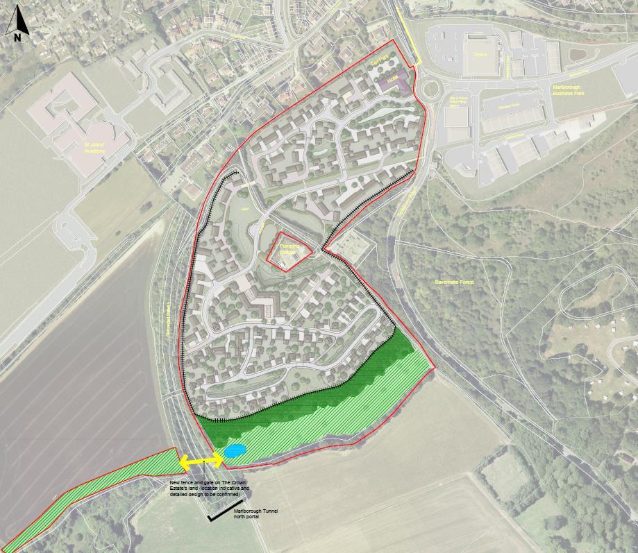
7 1 1. Non-technical Summary 1.1 What is proposed and what is the purpose of the Environmental Statement? The Crown Estate is applying for outline planning consent to develop an area of land known as Salisbury Road to the south of Marlborough in Wiltshire. This land is described in this report as the Site and covers an area of 14.3 hectares (ha). The planning application for this proposed development is accompanied by an Environmental Statement, as required under The Town and Country Planning (Environmental Impact Assessment) Regulations 2011 (SI 1824) (the EIA Regulations ). The preparation of this Environmental Statement, which has been undertaken by Amec Foster Wheeler Environment & Infrastructure Limited (Amec Foster Wheeler), forms part of the Environmental Impact Assessment (EIA) for the proposed development. This report is the Non-Technical Summary of the Environmental Statement. It summarises the content and conclusions of the Environmental Statement, to which readers should refer for further information. The following sections of the Non-Technical Summary describe: Why the proposed development is required; What land uses are present on the Site at the moment; What the proposed development would comprise; What alternatives have been considered; What does the EIA process involve; and What are the likely significant effects of the proposed development. The location of the Site is shown in Figure 1 with the boundary of the Site shown by the red line.

8 2 Figure 1 The Site location 1.2 Why is the proposed development required? The proposed development is needed to meet future demand for new housing. Wiltshire Council has undertaken studies to identify the likely demand for housing in the future and concluded that there is a need for 920 new dwellings between 2006 and 2026 within the town Marlborough and the surrounding villages. 537 houses have already been provided for which leaves 363 still needed. The proposed development is allocated in Wiltshire Council s plans for 220 homes to help contribute towards this need.
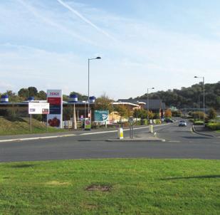
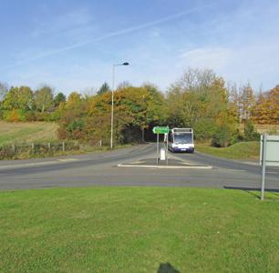
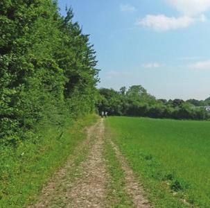
9 3 1.3 What is at the Site and in the surrounding area at the moment? The Site is currently arable agricultural land. A footpath (which is a Public Right of Way) runs through the middle of the Site in an approximate north-south direction. The field boundaries predominantly comprise hedgerows with standard trees. To the north, the Site is bordered by housing, with houses along the roads of Upper Churchfields and Cherry Orchard being the closest to the Site, together with a former adult training centre (now closed) and St John s School and Community College. To the south of the Site is a water pumping station and also an electricity substation. Further to the south and to the west is open farmland. To the south-east is Savernake Forest Site of Special Scientific Interest (this is a designated nature conservation site of national importance), which is also a Registered Park and Garden. To the east of the Site on the opposite side of the A346 is Marlborough Business Park providing a range of employment uses, a supermarket and a petrol station. 1.4 What development is proposed? The Crown Estate is applying for outline planning consent for: Up to 220 houses (up to two and half storeys in height); A hotel (up to three storeys in height); A new access road off the Salisbury Road / Blenheim Road roundabout; An area of short-term parking for use by parents/guardians dropping off children to go to St John s Academy within the centre of the development; Enhancements to the Public Right of Way running through the Site so that this can be used for pedestrian and cycle access to St Johns Academy and the town centre to the north; Open space and landscaping including children s play areas and amenity greenspace; A sustainable drainage system, which is a natural approach to managing drainage in and around a developments by holding back water that runs-off from a development using features such as balancing ponds; Associated works and services such as drainage infrastructure, footpaths and roads; and A new pedestrian crossing would be included on Salisbury Road linking the site with Tesco and Marlborough Business Park. The Crown Estate is applying for outline planning permission and plans to sell the Site to a developer which would then be responsible for applying for a second, more detailed level of planning permission, referred to as Reserved Matters. The proposed development is likely to be built over a four year period starting in 2016 and finishing in 2020.


10 4 The proposed land uses and buildings heights for the proposed development are shown in Figure 2. Figure 2 Land uses within the proposed development
11 5 1.5 What alternatives have been considered No alternatives to the Site have been considered as the Site was allocated by Wiltshire Council in a planning policy document known as the Wiltshire Core Strategy. However alternative layouts were considered as part of the design process. The Crown Estate originally considered a smaller site boundary enclosing an area of approximately nine hectares. This was a similar site area to that proposed originally by Wiltshire Council. The Crown Estate carried out initial consultation over the nine hectare area with Marlborough Town Council in Subsequently, technical studies identified several constraints within the Site including underground pipelines. This means that a larger area is required if the development is to accommodate 220 dwellings. Discussions with Wiltshire Council established that an assessment of the landscape and visual effects of the proposed development should be undertaken to establish how far south the development should be built. The public were consulted on these proposals in October Further studies have since been undertaken to determine the location of land uses within the proposed development. As a result of these studies, the hotel would be located in the north-eastern corner of the Site to minimise the effects from noise and traffic associated with the hotel on those living within the proposed development. The landscape and visual assessment identified how far up the slope within the southern part of the Site built development could go without having a likely significant adverse effect on the setting of Marlborough or the North Wessex Downs Area of Outstanding Natural Beauty. Ecological surveys have identified the species present on-site, which has influenced the design of the greenspace that would be created within the Site and the planting measures needed to ensure that these species are not likely to be significantly affected or the law that protects them is contravened. 1.6 What does the Environmental Impact Assessment process involve? EIA is a process that involves identifying and assessing a proposed development s likely environmental effects, both positive and negative, where these effects have the potential to be likely to be significant. This involves identifying how people and the environment could be affected by the proposed development and incorporating measures within the development to avoid, minimise or offset adverse effects and, where appropriate, to deliver environmental enhancements. Environmental information that is relevant to the assessment of the scheme, the assessment of potential likely significant effects, the evaluation of their significance and other relevant information is set out in an Environmental Statement. Nearly all development has some kind of effect, but the EIA process is about identifying whether these effects are likely to be significant or not. This Non-Technical Summary summarises the assessment and the conclusions as to whether the environmental effects of the proposed development are likely to be significant. Readers should refer to chapters 6 to 11 of the Environmental Statement (Volume 2 Main Report) and Volume 3 Appendices for more detailed technical information on the assessment, baseline information and methodologies which were used to assess the environmental effects of the proposed development. Separate reports (for example a Transport Assessment and Design and Access Statement) have also been completed in support of the planning application.
12 6 1.7 What are the likely predicted effects of the proposed development and are they likely to be significant? Air quality The proposed development could affect air quality in its vicinity and in Marlborough as a result of additional road traffic on local roads and a subsequent increase in pollutant emissions from vehicles. Wiltshire Council already monitors levels of air quality pollutants within Marlborough and the results from this show that Government targets in relation to air quality (known as air quality objectives) are being exceeded for nitrogen dioxide, a pollutant associated with vehicle emissions. If a local authority finds any places where these objectives are not likely to be achieved, it must declare an Air Quality Management Area there. Then the local authority will put together a plan to improve the air quality. Consequently, Wiltshire Council has declared the town of Marlborough, including the area where the Site is situated, to be an Air Quality Management Area. Amec Foster Wheeler has assessed the changes in nitrogen dioxide and particulate matter from the additional traffic flows that would be likely to result from the proposed development, as these are the pollutants most associated with road traffic. The concentrations of these pollutants were determined at the locations of residential properties along Salisbury Road which are likely to be exposed to any changes in emissions. As pollutant concentrations decrease with increasing distance from a road, these provided a worst-case assessment for all the receptors in the area with the potential to experience effects. The predicted concentrations of nitrogen dioxide and particulate matter, both with and without traffic from the development in 2021 (the year after which the development would be complete), were compared against the air quality objectives. The results showed that the additional traffic would not result in the air quality objectives for either nitrogen dioxide or particulate matter being exceeded. Therefore those currently living along Salisbury Road and in the wider area as well as the new residents living in the proposed development would not experience significant effects in relation to emissions from road traffic. Significant effects from increased dust during construction of the development would not occur as several standard measures would be put in place by the construction contractor to control dust emissions. Such measures would include covering stockpiles of material and vehicles entering and leaving the Site, regular sweeping of the access roads around the Site and dampening down of materials Historic Environment The Site is in close proximity to the historic town of Marlborough and was part of Savernake Forest in the medieval period; in 1200 AD the forest covered an area of some 100 square miles. By the early post-medieval period the Site was farmland and was likely part of the landholding belonging to St Margaret s Priory, part of the Gilbertine Order; the priory formerly stood to the north-east of the Site on the east side of the Salisbury Road in Marlborough. Archaeological evaluation has established the presence of finds and features of Late Neolithic and Iron Age within the Site but it is unlikely that there is any archaeological interest for the periods following prehistory.
13 7 There are no designated heritage assets 1 within the Site but there are several in the surrounding area, as summarised below. There are 430 listed buildings within 5km of the Site, of which 250 are in Marlborough; 176 of these within Marlborough Conservation Area, approximately 440m to the north of the Site. The closest listed building is Salisbury Road Lodge Gate which is a Grade II listed building 250m east of the Site, on the opposite side of the A346 Salisbury Road; Tottenham House and Savernake Forest is an extensive Grade II* registered park and garden, the boundary of which partly borders the eastern boundary of the Site; There are 33 scheduled monuments within 5km of the Site, which comprise a range of prehistoric, Roman and medieval sites, including a number of barrows. The closest scheduled monument is Castle Mound, locally known as the mount, 730m to the north-west of the Site, in the grounds of Marlborough School; and The World Heritage Site (WHS) of Stonehenge, Avebury and Associated Sites is also 4.3km to the west north-west of the Site at its nearest point. There is the potential that the change at the Site from arable land to built development could affect the setting of some of these heritage assets. However, the assessment has found that none of these effects are likely to be significant for the reasons summarised below. Effects on Tottenham House and Savernake Forest registered park and garden, would not be significant as views of the proposed development would be limited to those from part of the northern edge of the park, from where the proposed development would be seen alongside Marlborough Business Park and therefore would have little bearing on the asset; Effects on Salisbury Road Lodge Gate listed building would be not significant as the proposed development would form just one part of its overall setting, which already comprises an urban edge as it is located on the outskirts of Marlborough; Marlborough Conservation Area has very limited views towards the Site. Where changes to views have been identified, the development would be seen against the urban extent of the town and over a distance where the character of the proposed development would be difficult to discern against the rest of Marlborough, reducing the potential for any discernible contrast in character. Therefore effects would be not significant; and Effects on the setting of several scheduled monuments (Earthworks on Marlborough Common, Village settlement on Barton Down, Enclosure on Ogbourne Down and Bowl barrow 500m west of The Row) would not be significant largely because of the distance between the Site and the scheduled monument, which means that the proposed development would form a very small part of the overall setting of the asset. 1 Designated heritage assets include World Heritage Sites, Scheduled Monuments, Listed Buildings, Protected Wreck Sites, Registered Park or Gardens, Registered Battlefields and Conservation Areas which have been designated under relevant legislation.
14 8 Surveys to identify the potential for archaeological remains at the Site have been undertaken, involving geophysical survey and the excavation of trial trenches. These have shown that there are two broad areas of archaeological interest and potential within the Site. Within the northern part of the Site, the surveys found remains of early prehistoric (Late Neolithic) date. Due to their depth below the surface these features would be likely to be disturbed by the digging of foundations and trenches for services such as water and electricity. During these works, further investigation would therefore be undertaken to excavate and record these remains and, with these measures in place, effects would be not significant. Within the south-western part of the Site archaeological features relating to Iron Age activity were found. The construction of the proposed development would result in the loss of these features. However it is likely that, in the absence of the proposed development, these would be damaged and, eventually, lost completely due to disturbance from ploughing. The construction of the development would provide an opportunity to record the features before they are lost and overall the loss of these remains would be not significant Landscape and visual Landscape The site is located on the southern edge of Marlborough and is wholly set within the North Wessex Downs Area of Outstanding Natural Beauty (AONB). The site consists of two arable fields on the rising southern valley sides of the River Kennet and is surrounded by strong tree belts and woodland. The valley setting of the site and surrounding tree belts mean that the northern portion of the Site (immediately adjacent to Marlborough) is well screened whereas on rising ground to the south there is clear visibility between the Site and Marlborough. From these elevated southern parts of the site Marlborough is clearly visible cascading down the northern valley sides. The site lies beyond the existing settlement boundary but the influence of the town is strong, in particular as a consequence of the recently completed supermarket and industrial estate. Detailed consideration was given as part of the design process to how far up the slope to the south of the site new residential development could extend without adversely effecting the setting of Marlborough and views from the surrounding area, including the AONB. Mitigation incorporated into the scheme design is not solely focused on screening or hiding the development, but also takes inspiration from the existing built form in Marlborough on the opposite slopes. The cascading roofscape of the town contributes positively to the overall townscape character and its influence on the surrounding countryside. By reflecting this characteristic of the existing town, the proposed development represents a conscious and planned extension to the settlement. The assessment concludes that the development would deliver significant and beneficial effects to the townscape character. The proposed development would completely alter the character of the Site itself. The main landscape change would be associated with the permanent loss of the agricultural land and the introduction of new built form across the site. However, the assessment concludes that the localised nature of these changes and the sympathetic layout retaining key features would ensure that these effects are not significant.
15 9 Due to local topography and tree cover and due to the clear and distinct relationship between the Site and the existing settlement, the proposed development would not adversely affect the character or special qualities of the surrounding landscape. The empty, open downland so distinctive of the AONB would not be affected, nor the wooded plateau. Overall, the effect of this development upon the integrity, special qualities and character of the AONB, the townscape of Marlborough and the surrounding landscape character would be slight/moderate (not significant). The effect would reduce to negligible as tree cover matures and coalesces within the development, over a period of approximately 15 years. Visual effects The assessment concludes that distant views of the proposed development would be possible from some footpaths on the high downlands within the AONB. It concludes that by virtue of distance and the gradual coalescing of street and garden trees within the development, these changes in views would not represent significant effects. The assessment concludes that two groups of receptors would experience significant visual effects as a result of the proposed development. These are people using the public footpath that crosses the site north to south (who would therefore experience very close range views of the development where now there are arable fields) and motorists on the A346 Salisbury Hill. The significance of the change to views experienced by these motorists is a product of the valued gateway nature of the site on this route and the immediacy of the proposed development in views from it. The assessment concludes that the effect would be significant, however the design intent would be to create a positive new gateway to the town with a high quality design Biodiversity Desk studies and survey work have established that bats and dormice which are present in and around the Site, as well as the nearby Savernake Forest Site of Special Scientific Interest (SSSI; a nature conservation site of national importance), have the potential to be significantly affected by the proposed development. In addition, there is the potential for the legislation protecting badger and common reptile species to be contravened during development. The desk study and survey work established that bats hibernate within Marlborough Tunnel, part of a former railway line, and use the Site for commuting and foraging, with the woodland strip along the southern edge being an especially important commuting corridor between the Tunnel and Savernake Forest. To ensure that people living within the new development do not disturb the bats, a secure fence and gate would be provided on The Crown Estate s land to the north of the Tunnel to prevent public access around the Tunnel entrance. The bats could also be disturbed by the lighting and general activity associated with both the construction and occupation of the development. However new meadow and woodland planting would provide a buffer between the developed area and the Tunnel. Fencing along the southern edge of the development would prevent light spill on to the woodland to the south, with any residual light spill minimised by mature woodland planting.
16 10 Bats within the Tunnel and the wider area could also be affected by a loss of habitat which they use for foraging on invertebrate prey. Compensation for this habitat loss would be provided by the buffer planting described above, as well as further meadow planting adjacent to the proposed development. The meadow area near the Tunnel entrance would also include a pond which would provide a further source of insects for bats. With all the above mentioned measures in place, effects on bats are not likely to be significant. No badger setts are located within the area to be developed but a further survey for badger setts would be carried out prior to construction, and any new setts that could be affected by the proposed development would be avoided or closed under licence from Natural England. Measures would be put in place during construction to prevent harm to foraging badgers. In addition, new woodland, meadow and scrub planting would provide additional foraging resources for the local badger population. With these measures in place the legislation protecting badger would not be contravened by the development. To ensure that dormice are not affected by a loss of habitat the proposed development would compensate for the small amount (approximately 20m) of hedgerow that would be removed for the new access points into the Site with new woodland planting. To minimise the risk of predation of dormice by cats from the proposed development, catproof fencing would be erected between the development and the main areas of dormouse habitat. With these measures in place there are not likely to be significant effects on the local dormice population. To ensure that the reptiles are not killed during construction works, the reptiles would be moved away from areas of construction to the areas of new meadow habitat created next to the proposed development, which would also include habitat features to support reptiles. The legislation protecting reptiles would therefore not be contravened. Increased traffic along the A346 as a result of the development could increase the deposition of nitrogen-based air pollutants within the Savernake Forest SSSI. However, such effects would only take place within 40m of the road, thus affecting only a small percentage of the Forest. Taking into consideration predicted improvements in air quality during the lifetime of the development, the assessment found that air quality effects on the SSSI would not be likely to be significant. Breeding birds within Savernake Forest SSSI could be affected by increased numbers of visitors as a result of the proximity of the proposed development. The assessment found that the relatively small number of additional visitors likely to result from the development, compared with the existing population of Marlborough, was not likely to have a significant adverse effect in this regard. The measures that will be incorporated into the proposed development in relation to biodiversity are shown on Figure 3.

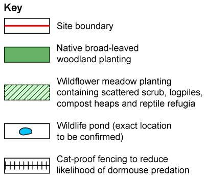
17 11 Figure 3 Biodiversity measures within the proposed development
18 Water environment The Site sits within the catchment of the River Kennet, although no watercourses flow across the Site. The majority of the Site is covered by a thin soil directly beneath which is the Chalk bedrock. The water table in the Chalk is located approximately 14 to 25 metres below ground level. Data collected at the Site indicate that groundwater quality is good. The southern part of the Site is within the Inner Source Protection Zone for a groundwater borehole from which water is abstracted to provide a public water supply for the town of Marlborough. This makes this part of the Site vulnerable to pollution or ground disturbance. Therefore several measures have been incorporated into the proposed development with the objective of avoiding such effects, including adherence to guidance prepared by the Environment Agency. With these measures in place significant effects on the drinking water supply are not likely. A Sustainable Drainage System would be included as part of the proposed development. Water draining from buildings rooftops would percolate into the ground via a sealed downpipe to a soakaway at each house. This would ensure that this clean water recharges the groundwater, from where it can be abstracted for local water supply. Drainage from the driveways at each house and the access roads (which could contain small concentrations of contaminants such as oils and heavy metals) would be directed via grass-lined channels (known as swales) to infiltration ponds, where it could percolate into the ground well away from the groundwater Source Protection Zone for the public water supply borehole to the north of the Site. In the proposed development the swales would be lined with an impermeable membrane beneath the soil of the swale. With these measures in place there would be no likely significant effects on the public drinking water supply. The flood risk at the Site from rivers is low. The high permeability of the Chalk aquifer underlying the Site and the depth to groundwater make the likelihood of a flood event low. Although the existing water supply infrastructure does not have sufficient capacity to meet the additional supply required by the new occupants of the proposed development, Thames Water, as the relevant statutory undertaker for water supply, has a duty to make sure that water can be supplied without abstraction licences being breached. For example, additional abstraction from the nearby River Kennet could only take place under the terms of Thames Water s abstraction licence issued by the Environment Agency. If this was not sufficient Thames Water would be required to provide water from other sustainable sources. There would therefore be no likely significant effects relating to abstraction. The developer will be required to put in place water efficiency measures such as making sure the appliances installed within the houses are water efficient. These measures will ensure that significant effects from increased water abstraction to supply the development are avoided.
19 Other environmental issues Early in the EIA process it was identified that the following effects were unlikely to be significant and therefore did not require detailed assessment. Reasons are provided below as to why these effects are not likely to be significant. Traffic and transport: An analysis of the increase in traffic flows during peak morning and evening hours has shown that the increase would be well below 10%. This is the threshold set out in guidance developed by the Institute of Environmental Management and Assessment, above which there is a need for a detailed assessment because of the potential for significant effects on pedestrians, cyclists and drivers in terms of delays, accidents, safety, fear and intimidation. Hence such effects would not be significant; Construction noise: During construction, measures would be put in place to control noise levels and all work would be limited to standard daytime working hours so that local people are not disturbed at quieter times of the day and night. As a result of these measures, the effects of construction noise on local people would not be significant; Traffic noise: A 25% increase in road traffic flows is needed for a one decibel increase in road traffic noise levels, which is the minimum change that studies have shown can be detected by the human ear in the short term. As discussed above, the increase in traffic flows as a result of the proposed development would be less than 10% and therefore audible increases in road traffic noise are unlikely. Hence there is not likely to be a significant effect on people as a result of the increase; Noise from the proposed hotel: Equipment which would be used at the hotel (such as extractor fans) would be located so that it does not front on to houses. If required, additional assessment would be undertaken at the detailed design stage of the hotel so that a noise limit for this equipment could be set. Socio-economics: The proposed development would create some jobs associated with the hotel. However, whilst beneficial, the number of jobs created is unlikely to be substantial enough to have a significant effect on local people searching for employment. To ensure that those living in the new development would not overload local services such as schools, healthcare facilities, community facilities such as libraries and leisure facilities, the developer would be required to provide funding to increase the provision of these services in the wider area. With this increased provision, there would not be likely to be any significant effects on local people; Land quality: An initial desk study has identified that the Site is likely to be free from soil and groundwater contamination. Once planning permission has been granted a more detailed study involving testing of soils would be undertaken to confirm this. Measures would be put in place to remove or remediate the contamination if any was found, thereby avoiding any significant effects; and Agricultural land: The amount of best and most versatile agricultural land that would be lost would be less than 0.1% of all of this type of land within Wiltshire. Such a small loss would not be significant.
20 Conclusions The assessment describes how a range of environmental measures have been built into the scheme s design to mitigate potentially adverse effects and deliver wider benefits. As a consequence, the only likely significant environmental effects as a result of the scheme are: Positive effects on the townscape of Marlborough; Negative effects on views from the Public Right of Way running through the site; and Negative effects on views from road users on the A346. There are no other significant effects identified in the assessment. 1.8 What happens next? Prior to determining the planning application, Wiltshire Council will seek advice from the Environment Agency, Natural England and other organisations. Members of the public will also be able to comment on the planning application. The normal period for determining a planning application such as this is 16 weeks. 1.9 Where can more information be found? The ES is available to view at Wiltshire Council s offices at the following address. County Hall, Bythesea Road, Trowbridge, Wiltshire BA14 8JN And online at
University Park, Worcester Non Technical Summary December 2011
 University Park, Worcester Non Technical Summary December 2011 Introduction UW Wrenbridge LLP, a Joint Venture Company of the University of Worcester and Wrenbridge Land Ltd (the Applicants ) intend to
Replacement Golf Course Facilities and Residential Development, Churston. Environmental Statement Non-Technical Summary
 Replacement Golf Course Facilities and Residential Development, Churston Environmental Statement Non-Technical Summary July 2011 Reproduced from the Ordnance Survey s map with the permission of the Controller
BREEDON NORTHERN LIMITED
 Non Technical Summary CONTENTS 1 INTRODUCTION... 1 2 SITE DESCRIPTION... 1 3 DESCRIPTION OF THE DEVELOPMENT... 6 4 NEED FOR THE DEVELOPMENT... 8 5 KEY ISSUES CONSIDERED IN THE ENVIRONMENTAL IMPACT ASSESSMENT...
Grantham Southern Quadrant Link Road Environmental Statement
 Grantham Southern Quadrant Link Road Environmental Statement Non Technical Summary Introduction Lincolnshire County Council (LCC) is submitting a planning application for the proposed implementation of
Longbridge Town Centre Phase 2 Planning Application
 Longbridge Town Centre Phase 2 Planning Application Non-Technical Summary of the Environmental Statement December 2013 Introduction A full application for Planning Permission has been submitted to Birmingham
South Whitehaven, Cumbria EIA
 South Whitehaven, Cumbria EIA Environmental Statement - Non Technical Summary June 2013 in association with 1. Introduction Story Homes is applying to Copeland Borough Council (CBC) for a new residential
LONDON BRIDGE STATION ENVIRONMENTAL STATEMENT NON-TECHNICAL SUMMARY
 LONDON BRIDGE STATION ENVIRONMENTAL STATEMENT NON-TECHNICAL SUMMARY June 2011 1 EXECUTIVE SUMMARY 2 INTRODUCTION CONTENTS Page 2.1 Introduction 4 2.2 The Site 4 3 THE DEVELOPMENT 3.1 What is it? 5 3.2
Welcome to our exhibition
 Welcome to our exhibition The Homes & Communities Agency (HCA) welcomes you to this public exhibition explaining our proposals for the redevelopment of the former Lea Castle Hospital site. About the Homes
ABBEY MANOR GROUP/SAINSBURY S SUPERMARKETS LTD
 ABBEY MANOR GROUP/SAINSBURY S SUPERMARKETS LTD Mixed Use Development including Business Park and Foodstore Land at Bunford Park, Bunford Lane, Yeovil Environmental Statement: Non-Technical Report June
NON-TECHNICAL SUMMARY
 Proposed Sand and Gravel Extraction and Associated Processing Operations with Restoration to a Mixture of Agriculture and Nature Conservation including Areas of Shallow Water at Hedgeley, Northumberland
Land at BROOK STREET PROPERTIES TENCREEK FARM, LISKEARD. Environmental Statement: Non-Technical Summary
 BROOK STREET PROPERTIES TENCREEK FARM, LISKEARD Land at Environmental Statement: Non-Technical Summary Introduction Brook Street Properties is applying to Cornwall Council for outline planning permission
The Trustees of the Standen Estate Land South of Clitheroe Non-Technical Summary
 1 The Trustees of the Standen Estate Land South of Clitheroe Non-Technical Summary 1. Introduction This report summarises the results of an assessment that has been undertaken to determine how a proposed
Barvills Solar Farm Environmental Statement Non-Technical Summary
 Barvills Solar Farm Environmental Statement Non-Technical Summary 13 March 2015 Produced for Prepared by St John s House Queen Street, Manchester M2 5JB Contents Contents... 2 1 Introduction... 3 1.1 Development
Sustainability Statement. Whitby Business Park Area Action Plan
 Sustainability Statement Whitby Business Park Area Action Plan November 2014 Contents Page 1. Introduction 1 2. Scoping 3 3. Sustainability Appraisal of Options 6 4. Assessment of Draft Area Action Plan
The Place Solar Farm
 The Place Solar Farm Environmental Statement Non-Technical Summary 28 August 2014 Produced for Prepared by St John s House Queen Street, Manchester M2 5JB Contents Contents... 2 1 Introduction... 3 1.1
LAND AT MIDDLETON STONEY ROAD AND HOWES LANE, BICESTER ENVIRONMENTAL STATEMENT NON-TECHNICAL SUMMARY. June 2017 Our Ref: Q70433
 LAND AT MIDDLETON STONEY ROAD AND HOWES LANE, BICESTER ENVIRONMENTAL STATEMENT NON-TECHNICAL SUMMARY June 2017 Our Ref: Q70433 Contents 1 INTRODUCTION... 2 2 SITE DESCRIPTION... 5 3 EIA METHODOLOGY...
LAND SECURITIES REDEVELOPMENT OF NEWNHAM COURT SHOPPING VILLAGE, MAIDSTONE
 LAND SECURITIES REDEVELOPMENT OF NEWNHAM COURT SHOPPING VILLAGE, MAIDSTONE Land at Environmental Statement: Non-Technical Summary Introduction Land Securities plc is applying to Maidstone Borough Council
ES 5. Drakelow Park. Environmental Statement. Volume 5: Non Technical Summary. Lead Author Waterman Energy, Environment and Design Ltd
 Drakelow Park ES 5 Environmental Statement Volume 5: Non Technical Summary Lead Author Waterman Energy, Environment and Design Ltd April 2009 Environmental Statement Volume 5: Non-Technical Summary DRAKELOW
ABOUT CALA HOMES CALA HOMES
 WELCOME Welcome to this public consultation event for our proposed development on land to the east of Salisbury Road, in Hungerford. Thank you for taking the time to come along today. Homes and Wates Developments
Statement of Community Involvement LAND OFF SOUTHDOWN ROAD HORNDEAN, HAMPSHIRE
 LAND OFF SOUTHDOWN ROAD HORNDEAN, HAMPSHIRE CONTENTS Page 1. Introduction 3 2. Pre-application Discussions 4 3. The Consultation Process 5 4. Consultation Feedback 7 5. Responses to Consultation Feedback
Meridian Water Phase 1 Application
 Meridian Water Phase 1 Application MW11 Environmental Statement Non-Technical Summary London Borough of Enfield March 2016 Contents 1 Introduction 1 2 The proposed development 2 3 Evolution of the proposed
Neighbourhood Planning Site Assessment Pro-forma and Guide Version 2
 Neighbourhood Planning Site Assessment Pro-forma and Guide Version 2 September 2014 Site HNP 006 Land East of Stanbridge Road and North of Lower Road 1. Background information Site location and use Site
LAND AT HOWES LANE, BICESTER ENVIRONMENTAL STATEMENT NON-TECHNICAL SUMMARY. March 2017 Our Ref: Q70433
 LAND AT HOWES LANE, BICESTER ENVIRONMENTAL STATEMENT NON-TECHNICAL SUMMARY March 2017 Our Ref: Q70433 Contents 1 INTRODUCTION AND SITE DESCRIPTION... 1 2 EIA METHODOLOGY... 5 3 ALTERNATIVES... 6 4 DESCRIPTION
Cranbrook EXPANSION ENVIRONMENTAL STATEMENT: NON-TECHNICAL SUMMARY PRODUCED BY DAVID LOCK ASSOCIATES
 Cranbrook EXPANSION ENVIRONMENTAL STATEMENT: NON-TECHNICAL SUMMARY PRODUCED BY DECEMBER 2014 CRANBROOK EXPANSION AREAS ENVIRONMENTAL STATEMENT NON TECHNICAL SUMMARY Submitted in support of Outline Planning
Site ref: AS06 Site Name or Address: Murreys Court, Agates Lane
 Site ref: AS06 Site Name or Address: Murreys Court, Agates Lane Proposed Land Use: Total Site Area (Ha): Housing 1.85 Ha Description: It is understood that the owner has no plans to dispose of the site
Response by the Wiltshire Archaeological and Natural History Society
 Highways England Consultation A303 Stonehenge Response by the Wiltshire Archaeological and Natural History Society Background About the Society Founded in 1853 to educate the public by promoting, fostering
Wyvern Park Skipton Environmental Statement. Non-technical Summary - April 2015
 Wyvern Park Skipton Environmental Statement Non-technical Summary - April 2015 BWB Consulting Ltd Whitehall Waterfront 2 Riverside Way Leeds LS1 4EH Telephone: +44(0)113 233 8000 Copyright This Report
LAND AT WEST YELLAND. Environmental Statement Non-Technical Summary Welbeck Strategic Land LLP
 LAND AT WEST YELLAND Environmental Statement Non-Technical Summary Welbeck Strategic Land LLP May 2014 Quality Management Issue/revision Issue 1 Revision 1 Revision 2 Revision 3 Remarks Draft FINAL Date
A303 Stonehenge. Amesbury to Berwick Down Scheme Assessment Report Appendix D CSR and Policy Assessment. Volume 6
 A0 Stonehenge Amesbury to Berwick Down Scheme Assessment Report Appendix D CSR and Policy Assessment Volume 6 September 2017 Appendix D Client Scheme Requirements (CSRs) and Policy Assessment D.1 CSR Assessment
Land North of Gallows Hill, Warwick
 Land North of Gallows Hill, Warwick Environmental Statement: Non Technical Summary Copyright and Non-Disclosure Notice The contents and layout of this report are subject to copyright owned by AMEC ( AMEC
7 Scoping and Introduction to the Assessments
 7 Scoping and Introduction to the Assessments 7.1 Scope of the assessments 7.1.1 Rule 8 of the TWR makes provision for an applicant to request a scoping opinion from the SoS indicating the information
Bloor Homes Stubbocks Walk North Hertfordshire ENVIRONMENTAL STATEMENT NON-TECHNICAL SUMMARY
 Bloor Homes Stubbocks Walk North Hertfordshire ENVIRONMENTAL STATEMENT NON-TECHNICAL SUMMARY December 2016 Environmental Statement: Non-Technical Summary Stubbocks Walk, North Hertfordshire J S Bloor
SPG 1. * the northern and western sections which are open fields used for pasture and grazing;
 SPG 1 1.0 INTRODUCTION This development brief is based on the allocation of the Priors Hall site for employment and countryside recreational purposes in the Corby Borough Local Plan. The brief is intended
HS2 Environment. Protecting the environment
 HS2 Environment Protecting the environment Approach to mitigation EIA Regulations require an ES to include a description of the measures envisaged in order to avoid, reduce and, if possible, remedy significant
PERSIMMON HOMES (SW) LIMITED LAND AT ADDINGTON, LISKEARD ENVIRONMENTAL STATEMENT NON-TECHNICAL SUMMARY
 LIMITED LAND AT ADDINGTON, LISKEARD ENVIRONMENTAL STATEMENT NON-TECHNICAL SUMMARY") PERSIMMON HOMES (SW) LIMITED LAND AT ADDINGTON, LISKEARD ENVIRONMENTAL STATEMENT NON-TECHNICAL SUMMARY APRIL 2010 INTRODUCTION This document is the Non-Technical Summary (NTS) of an Environmental Statement
PERSIMMON HOMES (SW) LIMITED LAND AT ADDINGTON, LISKEARD ENVIRONMENTAL STATEMENT NON-TECHNICAL SUMMARY APRIL 2010 INTRODUCTION This document is the Non-Technical Summary (NTS) of an Environmental Statement
The Town and Country Planning (Environmental Impact Assessment) (Wales) Regulations 2016, Regulation 13 Scoping Opinion
 (Wales) Regulations 2016, Regulation 13 Scoping Opinion") Mr Graham Clark Berrys Newchurch Farm Kinnersley Hereford HR3 6QQ BY EMAIL The Town and Country Planning (Environmental Impact Assessment) (Wales) Regulations 2016, Regulation 13 Scoping Opinion SC/2017/0001
Mr Graham Clark Berrys Newchurch Farm Kinnersley Hereford HR3 6QQ BY EMAIL The Town and Country Planning (Environmental Impact Assessment) (Wales) Regulations 2016, Regulation 13 Scoping Opinion SC/2017/0001
Moat Lane Regeneration Project Environmental Statement
 AECOM Environment Towcester Regeneration Ltd. October 2012 Moat Lane Regeneration Project Environmental Statement Non-Technical Summary Prepared by:... Checked by:... Sophie Collins Scott Wilson Environmental
Land at Weymouth Gateway Proposed hotel and pub / restaurant Non-technical summary. Premier Inns Ltd February 2011
 February 2011 Introduction NTS.1 In April 2007, New Look Retailers Ltd submitted an outline planning application to Weymouth and Portland Borough Council to redevelop the Mount Pleasant Business Park
INTRODUCTION. Land south of Bishopswood Lane, Tadley
 0 INTRODUCTION THE SITE Introduction Gladman Developments Ltd. has successfully invested in communities throughout the UK over the past 0 years, developing high quality and sustainable residential, commercial
Environmental Statement
 Non-technical summary (NTS) Introduction Site description and development proposals Environmental issues and methodology Air quality Community and social effects Cultural heritage: designated heritage
NON-TECHNICAL SUMMARY
 NON-TECHNICAL SUMMARY THE HIDE, BISHOP AUCKLAND PROPOSED ECO CHALET DEVELOPMENT NON-TECHNICAL SUMMARY 1 Introduction 1.1.1 This non-technical summary for the (ES) prepared in relation to the proposed eco-chalet
Public Consultation. Land at Monks Farm, North Grove. Welcome
 Welcome Welcome to our public exhibition for development on Land at Monks Farm, orth Grove. Gallagher Estates and Gleeson Strategic Land are preparing an outline planning application for new homes, open
VALLEY PARK, DIDCOT. Non-Technical Summary. December On behalf of Taylor Wimpey UK Limited, Persimmon Homes and Hallam Land Management Ltd.
 VALLEY PARK, DIDCOT Non-Technical Summary December 2014 On behalf of Taylor Wimpey UK Limited, Persimmon Homes and Hallam Land Management Ltd. CONTENTS 1 Introduction... 2 2 The Proposed Development...
LAND NORTH OF NETHERHOUSE COPSE, FLEET
 REPORT N O 70020067 LAND NORTH OF NETHERHOUSE COPSE, FLEET ENVIRONMENTAL STATEMENT VOLUME 3:NON-TECHNICAL SUMMARY OF THE ENVIRONMENTAL STATEMENT PUBLIC JUNE 2016 LAND NORTH OF NETHERHOUSE COPSE, FLEET
Former RAF Sealand Site EIA
 Praxis (Holdings) Ltd. Former RAF Sealand Site EIA Environmental Statement - Non Technical Summary February 2012 in association with P a g e 1 1. Introduction Praxis (Holdings) Ltd. is applying to Flintshire
Elvetham Chase, Fleet. Environmental Statement: Non-Technical Summary. November New Fetter Lane London EC4A 1AZ United Kingdom
 Elvetham Chase, Fleet Environmental Statement: Non-Technical Summary November 2016 A Ne w F e tte r P lace 8-10 New Fetter Lane London EC4A 1AZ United Kingdom T +44 (0) 20 7467 1470 F +44 (0) 20 7467 1471
HRA PLANNING Chartered Town Planning and Environmental Consultants
 HRA PLANNING Chartered Town Planning and Environmental Consultants Screening Statement for the Purposes of Determining the need for Appropriate Assessment Proposed development of 74 no. residential units
London Road, Derker. Non Technical Summary. Introduction
 London Road, Derker Non Technical Summary Introduction The Oldham Rochdale Housing Market Pathfinder was set up to tackle longstanding problems of poor quality housing and to provide the framework for
DEFGH. Crystal Place Park. Environmental Impact Assessment (EIA) Elin Thomas and Emily Low Waterman Environmental
 Elin Thomas and Emily Low Waterman Environmental") DEFGH Crystal Place Park Environmental Impact Assessment (EIA) Elin Thomas and Emily Low Waterman Environmental 10.12.07 EIA Presentation Content What is EIA? Legal Requirements Process Q&A Key Topics
DEFGH Crystal Place Park Environmental Impact Assessment (EIA) Elin Thomas and Emily Low Waterman Environmental 10.12.07 EIA Presentation Content What is EIA? Legal Requirements Process Q&A Key Topics
Chapter 4. Route Window C12: Mile End Park and Eleanor Street Shafts
 Chapter 4 Route Window C12: Mile End Park and Eleanor Street Shafts 48 Crossrail Amendment of Provisions 4 Route Window C12: Mile End Park and Eleanor Street Shafts Location plan of Mile End Park and Eleanor
PINEWOODS HOLIDAY PARK: HORSE PADDOCK. Non-Technical Summary
 PINEWOODS HOLIDAY PARK: HORSE PADDOCK June 2014 1 Introduction 1.1 The existing Pinewoods Holiday Park is located approximately 1 km to the north of Wells-nextthe-Sea on the north Norfolk coast. Pinewoods
Ref: A073350/SM/sm Date: 13 September 2013
 Ref: A073350/SM/sm Date: 13 September 2013 Ian Parkinson Development Control Team Leader Planning Portsmouth City Council Civic Offices Guildhall Square Portsmouth PO1 2AY Dear Ian LIGHT & GLEAVE VILLA
ROCHFORD LOCAL DEVELOPMENT FRAMEWORK: Sustainability Appraisal/ Strategic Environmental Assessment. Rochford Core Strategy Preferred Options Document
 ROCHFORD LOCAL DEVELOPMENT FRAMEWORK: Sustainability Appraisal/ Strategic Environmental Assessment Non Technical Summary Rochford Core Strategy Preferred Options Document October 2008 SUSTAINABILITY APPRAISAL
Examination of South Cambridgeshire Local Plan
 Matter SC6A - Policy SS/5 Waterbeach New Town Historic England( formerly English Heritage) 874 Rep Nos 59748, 60250, 60253 Examination of South Cambridgeshire Local Plan Historic England, Hearing Statement
9 Archaeology & Cultural Heritage
 High Clachaig Wind Farm Scoping Report Page 56 9 Archaeology & Cultural Heritage 9.1 Introduction Cultural heritage in this context means the above- and below-ground archaeological resources, built heritage,
NON-TECHNICAL SUMMARY
 Hybrid outline/detailed planning application comprising an outline planning application for 196 residential dwellings, landscaping, open space, estate roads and infrastructure, plus 4 permanent gypsy and
Date: TOWN AND COUNTRY PLANNING (ENVIRONMENTAL IMPACT ASSESSMENT) REGULATIONS 2011: REGULATION 13 SCOPING OPINION
 REGULATIONS 2011: REGULATION 13 SCOPING OPINION") PLANNING & BUILDING CONTROL Tracy Harvey Head of Planning & Building Control Rob Wells Savills Innovation Court 121 Edmund Street Birmingham B3 2HJ Our Ref: 5/16/3441 E-mail: Date: planning@stalbans.gov.uk
PLANNING & BUILDING CONTROL Tracy Harvey Head of Planning & Building Control Rob Wells Savills Innovation Court 121 Edmund Street Birmingham B3 2HJ Our Ref: 5/16/3441 E-mail: Date: planning@stalbans.gov.uk
UTT/17/2075/FUL - (BERDEN) (Referred to Committee by Councillor Janice Loughlin. Reason: In the Public Interest)
 (Referred to Committee by Councillor Janice Loughlin. Reason: In the Public Interest)") UTT/17/2075/FUL - (BERDEN) (Referred to Committee by Councillor Janice Loughlin. Reason: In the Public Interest) PROPOSAL: LOCATION: APPLICANT: Amendments to the design of a scheme for a 49.99MW battery
UTT/17/2075/FUL - (BERDEN) (Referred to Committee by Councillor Janice Loughlin. Reason: In the Public Interest) PROPOSAL: LOCATION: APPLICANT: Amendments to the design of a scheme for a 49.99MW battery
Thornton Road, Pickering Environmental Statement Non-Technical Summary. January 2016
 Thornton Road, Pickering Environmental Statement Non-Technical Summary January 2016 EIA Quality This Environmental Statement, and the Environmental Impact Assessment (EIA) carried out to identify the significant
Environmental Impact Assessment for Waterway Restoration Projects. Chris John, Technical Director Ecus Ltd.
 Environmental Impact Assessment for Waterway Restoration Projects Chris John, Technical Director Ecus Ltd. Environmental Impact Assessment for Waterway Restoration Projects What is Environmental Impact
PERRYFIELDS BROMSGROVE. ENVIRONMENTAL STATEMENT - NON-TECHNICAL SUMMARY December 2015
 PERRYFIELDS BROMSGROVE ENVIRONMENTAL STATEMENT - NON-TECHNICAL SUMMARY December 2015 Environmental Statement Non-technical summary CONTENTS 1 Introduction 2 The Site and local context 3 Description of
Ward: Southbourne. Outline application with all matters reserved. Erection of 5 no. dwellings and associated works.
 Parish: Southbourne Ward: Southbourne SB/16/00205/OUT Proposal Site Outline application with all matters reserved. Erection of 5 no. dwellings and associated works. Dunkirk South Lane Southbourne Emsworth
Site Assessment Technical Document Appendix A: Glossary
 Central Bedfordshire Council www.centralbedfordshire.gov.uk Site Assessment Technical Document Appendix A: Glossary July 2017 1.1.11-1 - ii Appendix A: Glossary Term Agricultural Land Classification AONB
Land to the North of Main Road, Wybunbury
 Land to the North of Main Road, Wybunbury Environmental Statement Non-Technical Summary November 2014 Land to the North of Main Road, Wybunbury Environmental Statement Non-Technical Summary Prepared on
Kings Road Industrial Development, Immingham. Environmental Impact Assessment. Non Technical Summary
 Environmental Impact Assessment Non Technical Summary Report prepared by: Ecus Ltd. Brook Holt 3 Blackburn Road Sheffield S61 2DW 0114 266 9292 December 2013 Page left intentionally blank INTRODUCTION
Land at Rampton Road. Cottenham
 Land at Rampton Road Cottenham Introduction TEP is preparing an outline planning application for 54 dwellings on 6.9 hectares of land adjacent to Rampton Road, Cottenham on behalf of the owners Cambridgeshire
Kilnw Envir ood Vale onmental Statement Volume 3: Non Technical Summary July 2010
 Kilnwood Vale Environmental Statement Volume 3: Non Technical Summary July 2010 Kilnwood Vale Environmental Impact Assessment Environmental Statement Volume 3 KILNWOOD VALE ENVIRONMENTAL STATEMENT NON-TECHNICAL
17A. Wind Microclimate
 17A. Wind Microclimate 17A.1 Introduction 17A.1.1 17A.1.2 17A.1.3 17A.1.4 This Chapter, which has been prepared by Waterman and BMT, provides further information with regard to the potential wind microclimate
Dormouse Method Statement
 , Northamptonshire A Report on behalf of April 2013 CONTENTS 1.0 Introduction 1.1 Purpose of this Method Statement 1.2 Site Background 1.3 Dormouse Ecology & Legal Protection 2.0 Methodology 2.1 Tool Box
NON TECHNICAL SUMMARY
 NON TECHNICAL SUMMARY INTRODUCTION NTS.1 CEMEX UK Properties Limited is applying for planning permission to South Cambridgeshire District Council (SCDC) for the redevelopment of the former CEMEX cement
MAIDSTONE MEDICAL CAMPUS LTD LAND AT NEWNHAM PARK, MAIDSTONE
 MAIDSTONE MEDICAL CAMPUS LTD LAND AT NEWNHAM PARK, MAIDSTONE Land at Environmental Statement: Non-Technical Summary Introduction Maidstone Medical Campus Ltd is applying to Maidstone Borough Council for
Re-location of Rugby Farmers Mart
 Re-location of Rugby Farmers Mart LaSalle Investment Management Barberry Logo here Environmental Statement Non-Technical Summary August 2017 Re-location of Rugby Farmers Mart Non-Technical Summary Report
Non-technical summary
 Non-technical summary Introduction NTS.1 is applying for outline planning permission for a residential development of up to 80 dwellings on land at Hambrook, on the northern fringe of Bristol. NTS.2 An
Proposed World-Class Hotel at Former Royal High School, Regent Road, Edinburgh
 Duddingston House Properties and Urbanist Hotels Proposed World-Class Hotel at Former Royal High School, Regent Road, Edinburgh Environmental Statement Non-Technical Summary 3rd September 2015 www.oldroyalhighschool.com
Blandford Forum Town Council, Blandford St Mary Parish Council and Bryanston Parish Council
 Blandford Forum Town Council, Blandford St Mary Parish Council and Bryanston Parish Council Blandford + Neighbourhood Plan 2 Pre-Submission Plan Consultation (November 2018) Representations submitted on
Carterton Construction Ltd is bringing forward plans for up to 85 new family homes and extra care facilities on land east of Burford.
 Welcome Carterton Construction Ltd is bringing forward plans for up to 85 new family homes and extra care facilities on land east of. We are at the early stages of designing our proposals and have a number
Request for a Scoping Opinion by Provectus. Proposed Surface Mining of Coal on Land west off the A61, Hill Top Farm, Clay Cross, Derbyshire
 Request for a Scoping Opinion by Provectus Proposed Surface Mining of Coal on Land west off the A61, Hill Top Farm, Clay Cross, Derbyshire January 2012 Contents 1 Introduction & Background... 1 2 Site
LONGDEN VILLAGE DEVELOPMENT STATEMENT
 LONGDEN VILLAGE DEVELOPMENT STATEMENT 2017-2027 1 Longden Development Statement 2017-2027 15/01/18 1. Background 1.1 Longden Village Longden village is a very rural and traditional community first mentioned
SOUTH CAMBRIDGESHIRE DISTRICT COUNCIL. Planning and New Communities Director
 SOUTH CAMBRIDGESHIRE DISTRICT COUNCIL REPORT TO: Planning Committee 5 June 2013 AUTHOR/S: Planning and New Communities Director S/0747/13/FL HISTON Construction of Car Park at Histon Baptist Church, Station
CALA Homes is preparing a planning application for a development of up to 36 new homes, including a mix of properties to meet local demand.
 WELCOME Welcome to this public consultation event for our proposed development on land to the south of Twelve Leys in Wingrave. Thank you for taking the time to come along today. Homes is preparing a planning
M4 Corridor around Newport Environmental Statement Volume 3: Appendices
 Environmental Statement Volume 3: Appendices Environmental Statement Volume 3: Appendices At Issue March 2016 CVJV/AAR 3 rd Floor Longross Court, 47 Newport Road, Cardiff CF24 0AD Volume 3: Contents 1
NON TECHNICAL SUMMARY
 CONTENTS Introduction...1 Site Setting and Description...3 Proposed Development...3 Proposed Time Extension...4 Proposed Lateral Extension...4 Improvement of the main access road (Downs Lane)...4 Restoration
PANSHANGER QUARRY, Hertfordshire
 PANSHANGER QUARRY, Hertfordshire Proposed enhanced restoration of Phases F & H Briefing Note 1 March 2015 INERT (INACTIVE) RESTORATION MATERIALS, CONTROLS AND OPERATIONS 1 Introduction This briefing note
Town and Country Planning (Environmental Impact Assessment Regulations) 2011 SCOPING OPINION
 2011 SCOPING OPINION") Town and Country Planning (Environmental Impact Assessment Regulations) 2011 SCOPING OPINION Application Site and Description of Development Proposed new quarry at Culham, Oxfordshire Land and Mineral
Town and Country Planning (Environmental Impact Assessment Regulations) 2011 SCOPING OPINION Application Site and Description of Development Proposed new quarry at Culham, Oxfordshire Land and Mineral
Longbridge East : Site Wide and Phase One Development
 Longbridge East : Site Wide and Phase One Development Non-Technical Summary of the August 2011 Introduction St Modwen Developments Ltd intend to submit a new outline planning application for Longbridge
Cardiff International Sports Village Waterfront Development Volume IV : Non-Technical Summary of the Environmental Statement
 Greenbank Partnerships Ltd October 2012 Cardiff International Sports Village Waterfront Development Volume IV : Non-Technical Summary of the Environmental Statement Environmental Statement - Non Technical
Rochford District Council Allocations Development Plan Document: Discussion and Consultation Document Sustainability Appraisal
 Option SWH1 Balanced Communities Option SWH1 1 To ensure the delivery of high quality sustainable communities where people want to live and work Will it ensure the phasing of infrastructure, including
WELCOME. Welcome and thank you for visiting today.
 WELCOME Welcome and thank you for visiting today. Bellway Homes Ltd (Yorkshire) are preparing a reserved matters planning application for a residential development of 293 homes at land North of Yew Tree
Welcome to our public exhibition
 About our development Welcome to our public exhibition This exhibition gives you the chance to view and comment on our proposals for a new residential development of 165 high-quality homes, along with
Dolphingstone Farm, Prestonpans Environmental Statement. Non-Technical Summary. June Waterman Energy, Environment & Design Limited
 Dolphingstone Farm, Prestonpans Environmental Statement June 2015 Waterman Energy, Environment & Design Limited Third Floor, South Suite, 8 Nelson Mandela Place, Glasgow, G2 1BT, United Kingdom Introduction
LAND AT PARK MILL FARM, PRINCES RISBOROUGH ENVIRONMENTAL STATEMENT SUPPLEMENT NON-TECHNICAL SUMMARY
 LAND AT PARK MILL FARM, PRINCES RISBOROUGH ENVIRONMENTAL STATEMENT SUPPLEMENT NON-TECHNICAL SUMMARY May 2016 CONTENTS CONTENTS... i 1 Introduction... 1 2 The Proposed Development... 3 3 Need and Alternatives
Introduction. Welcome to this consultation regarding the draft redevelopment proposals for the former CeramTec factory on Sidmouth Road, Colyton.
 Introduction Welcome to this consultation regarding the draft redevelopment proposals for the former CeramTec factory on Sidmouth Road, Colyton. We are currently considering options for the mixed-use redevelopment
XII IX VIII NON-TECHNICAL SUMMARY OF ENVIRONMENTAL STATEMENT. Redevelopment of the Laverstoke Mill Complex
 Laverstoke Mill XI XII Redevelopment of the Laverstoke Mill Complex I X NON-TECHNICAL SUMMARY OF ENVIRONMENTAL STATEMENT November 29 IX VIII St James Group Ltd Berkeley House, 19 Portsmouth Road, Cobham,
Project Wellesley. Environmental Statement Volume 1 Non-Technical Summary
 Project Wellesley Environmental Statement Volume 1 Non-Technical Summary November 2012 2 Prepared For Rob Sanderson Defence Infrastructure Organisation Sutton Coldfield Prepared By AMEC Environment & Infrastructure
A38 Derby Junctions. Preliminary Environmental Information Report: Non-Technical Summary
 Preliminary Environmental Information Report: Preliminary Environmental Information Report Report No: P01 S4 September 2018 Table of contents Introduction... 1 The proposed scheme... 2 Scheme details...
South Macclesfield Development Area Environmental Statement Non-Technical Summary March 2017
 South Macclesfield Development Area Environmental Statement March 2017 Contents 1.0 Introduction... 2 1.1 Background... 2 1.2 Environmental Assessment... 2 1.3 Site Description... 2 2.0 The Proposals...
Peckham Peckham Area Vision Map
 Area Vision Map PNAAP13 PNAAP8 Sumner Road Surrey Canal Walk Bird in Bush Park Key: NSP Site Allocations PNAAP Allocations Greenspace Low Line Cycle Network Primary Shopping Areas Square Surrey Canal Walk
Reserved Matters application for a site that straddles the boundary between CBC and BBC
 BBC APPLICATION 15/02682/MAR NUMBER CBC APPLICATION CB/15/04294/RM NUMBER LOCATION Wixams Land at former storage depot, Bedford Road, Wilstead Bedfordshire PROPOSAL Reserved Matters Application for Strategic
Ashtead Neighbourhood Forum Site Assessment AS07 Old Chalk Pit, Pleasure Pit Road. Site ref: AS07 Site address: Old Chalk Pit, Pleasure Pit Road
 Site ref: AS07 Site address: Old Chalk Pit, Pleasure Pit Road Proposed Land Use: Total Site Area (Ha): Housing 0.7ha Description: The site was formally an old chalk pit that has been partially filled and
Burnley and Pendle Strategic Outline Business Case. Environmental Report
 Burnley and Pendle Strategic Outline Business Case Environmental Report July 2015 Document control sheet BPP 04 F8 version 17 July 2014 Project: SOBC Client: Lancashire County Council Project Number: B2237505