Pedestrian and Cycle Bridge Feasibility Study Report Summary
|
|
|
- Ralf Mitchell Holland
- 5 years ago
- Views:
Transcription


1 Pedestrian and Cycle Bridge Feasibility Study Report Summary For London Borough of Richmond July 2018
2 OBJECTIVES The primary objective of introducing a new bridge across the Thames in Richmond is to improve connectivity, thereby increasing access to homes, jobs, services, leisure activities and transport links. The full list of objectives is identified below: Provide a more pleasant and safer journey experience for pedestrians and cyclists who currently suffer from poor amenity on existing bridges. Improve the health and wellbeing of residents and others by affecting a mode shift from motorised modes to walking and cycling, and by encouraging new trips to be made by active modes. Provide a more direct and coherent route for short journeys over the river and to link into the wider network for longer trips. This will help to connect people to homes, jobs, services, leisure activities and public transport nodes. Support the potential for growth and regeneration. Contribute to improving the public realm and public spaces around the bridge, and help to activate these areas. A new crossing which meets the above objectives will contribute towards the delivery of a number of policies and proposals in the Mayor s Transport Strategy including: Healthy streets and healthy people: MTS Policy 1: reduce dependency on cars in favour of active, efficient and sustainable modes of travel MTS Policy 2: seek to make London a city where people choose to walk and cycle more often MTS Policy 3: adopt Vision Zero for road danger in London MTS Policy 5: prioritise space efficient modes of transport to tackle congestion and improve the efficiency of streets for the movement of people and goods New homes and jobs: MTS Policy 21: ensure that new homes and jobs in London are delivered in line with the transport principles of Good Growth
3 APPROACH The approach to the study has been structured with the aim to answer the following key questions: Where are the most promising locations for new cycle/pedestrian bridges? What level of demand is there for the new bridges compared to the existing bridges? What potential issues and constraints may impact on implementing the bridges? What opportunities do the bridges provide for improving connectivity? Will the bridges provide value for money? The study has been split into two key stages: Stage 1: Desktop Review, Data Collection and Location Shortlisting Stage 2: Appraisal of Specific Sites


4 CONTEXT EXISTING BRIDGES 4 LB Hammersmtih & Fulham LB Hounslow LB Richmond LB Richmond RB Kingston Elmbridge BC
5 CONTEXT EXISTING BRIDGES Bridge Design type, completion date Length Width Cycle Lane? Access Other features 12-Hour Ped. Count 12-Hour Cycle Count Total count Hammersmith Bridge Suspension Bridge, 2 piers (1887) 210m 13m No, on road only Steps + footway/ road Narrow traffic lanes, veh/day 3,872 1,923 5,795 Barnes Footbridge Deck arch bridge, 2 piers (1895) Chiswick Bridge Deck arch bridge, 2 piers (1933) 124m 2.4m No, foot bridge only Steps Runs alongside railway bridge 185m 21m Yes - shared with pedestrians Steps + shared use path 1, ,479 40,000 veh/day Kew Bridge Arch, 2 piers (1903) 360m 23m Yes - shared with pedestrians Richmond Footbridge Deck arch bridge, 3 piers (1894) Steps + shared use path - 76m 8m No, foot bridge only Steps Split into two 2m walkways Twickenham Bridge Arch, 2 piers (1933) 118m 20m Yes - shared with pedestrians Steps + shared use path - 1,665 1,041 2, , ,456 Richmond Bridge Stone arch bridge, 4 piers (1777) 91m 11m No, on road only Steps + footway/ road Narrow traffic lanes, 35,000 veh/day 5,258 1,457 6,715 Teddington Footbridge Suspension, single span (1889) 100m 3m No, foot bridge only Steps + ramps - 1,544 1,042 2,585 Kingston Bridge Stone Arch, 4 piers (1828) 116m 24m Yes shared with pedestrians Steps + shared use path 50,000 veh/day 4,781 2,302 7,084 Hampton Court Bridge Concrete Arch, 2 piers (1933) 97m 21m Yes shared with pedestrians Road - 3,899 1,457 5,356
6 CONTEXT EXISTING DEMAND


7 WALKING AND CYCLING DEMAND - APPROACH Key assumptions made regarding demand, including 2km/8km catchment, no mode shift from tube/rail, mode shift targets cycling/walking The scale of development is relatively low, with around 2,000 residential units, 26,000sqm education, 90,000sqm office and 25,000sqm retail space planned within a 2km catchment of the bridges. The largest residential development in relatively close proximity is 910 units, which is located about 1km from bridge 21b
8 SHORTLISTED SITES
9 SHORTLISTED SITES DISCOUNTED
10
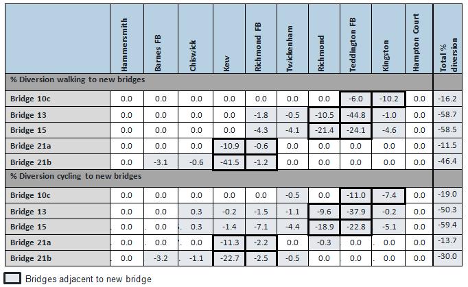
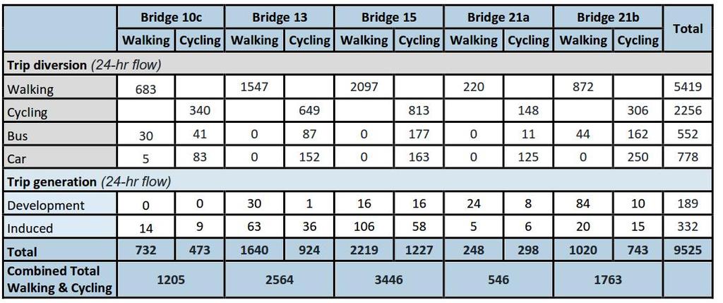
11 SHORTLISTED BRIDGE LOCATIONS - DEMAND
12 DEMAND COMPARED TO EXISTING BRIDGES 1. Bridge pedestrian and cycle trips, 5th busiest bridge 2. Bridge pedestrian and cycle trips, 6th busiest bridge 3. Bridge 21b 1763 pedestrian and cycle trips, 7th busiest bridge 4. Bridge 10c 1205 pedestrian and cycle trips, 10th busiest bridge 5. Bridge 21a 546 pedestrian and cycle trips, 11th busiest bridge
13 DEMAND COMPARED TO EXISTING BRIDGES
14 DEMAND COMPARED TO EXISTING BRIDGES
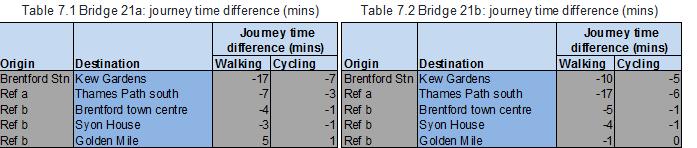
15 ACCESSIBILITY BRIDGES 21A & 21B
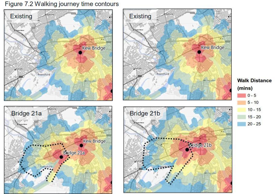
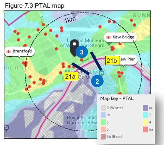
16 ACCESSIBILITY BRIDGES 21A & 21B
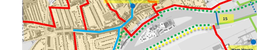
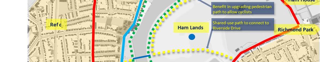
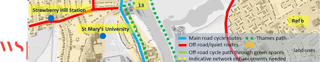
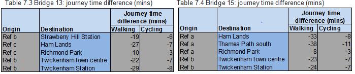
17 ACCESSIBILITY BRIDGES 13 & 15
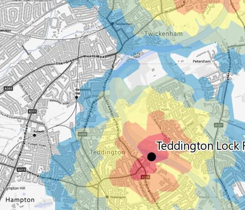
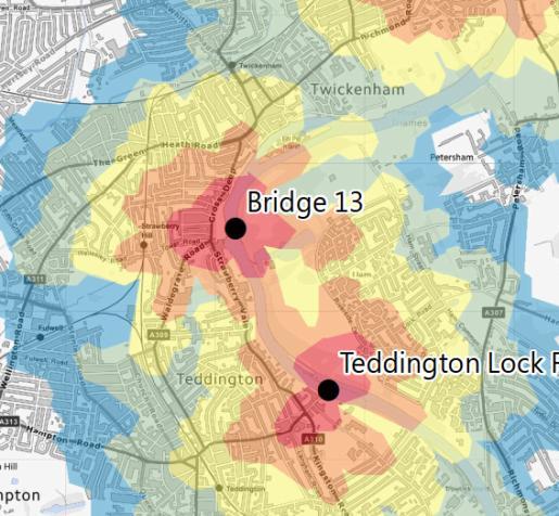
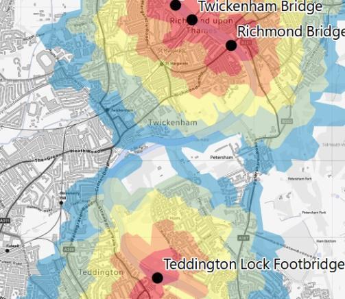
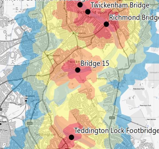
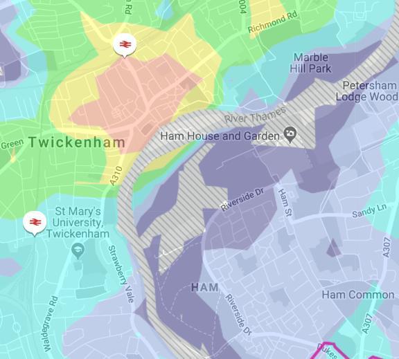
18 ACCESSIBILITY BRIDGES 13 & 15 Figure 7.5 Walking journey time isochrones Figure 7.6 PTAL map 3 1b a 2 13
")


19 ACCESSIBILITY BRIDGES 10C Journey time difference (mins) Origin Destination Walking Cycling Ref a Richmond Park -5-1 Ref a Sainsbury's 3-1 Ref b Hampton Wick 0 0 Ref b St Mary's University -9-3


20 ACCESSIBILITY BRIDGES 10C Figure 7.8 Walking journey time isochrones Existing Bridge 10c Figure 7.9 PTAL map 1a 1b 3 10c 6a

21 BRIDGE DESIGN Figure 8.1 Bridge design types Precast concrete beams Figure 8.3 Bridge design assumptions Steel composite Steel truss Steel tied arch Cable stayed
22 LANDING SITE CONSIDERATIONS Site specific assessment of the constraints and risks for each location, which include the following: Land ownership Network connections Aesthetic and heritage sensitivities Flood risk Moorings Conservation areas Protected trees Visual intrusion Opportunities Potential for commercial activity and/or development Local area enhancement


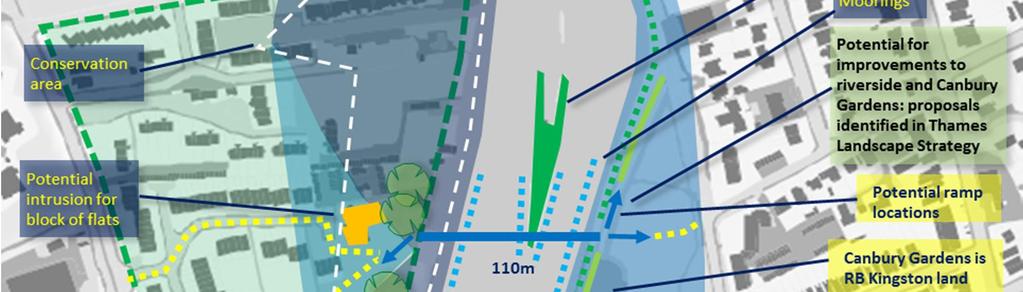
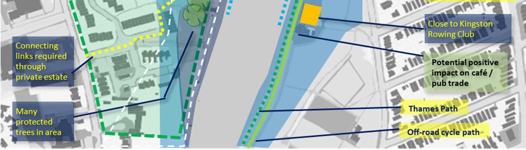
23 LANDING SITE CONSIDERATIONS BRIDGE 10C Figure 8.5 Bridge 10c location: views from Canbury Gardens

24 LANDING SITE CONSIDERATIONS BRIDGE 10C
 LANDING SITE CONSIDERATIONS")


25 View north along Thames Path(east side) LANDING SITE CONSIDERATIONS BRIDGE 13 Figure 8.7 Bridge 13 location View west to Radnor Gardens View east through Ham Lands where new shared use path is required to connect to Riverside Drive


26 LANDING SITE CONSIDERATIONS BRIDGE 13 Figure 8.6 Bridge13 landing site considerations


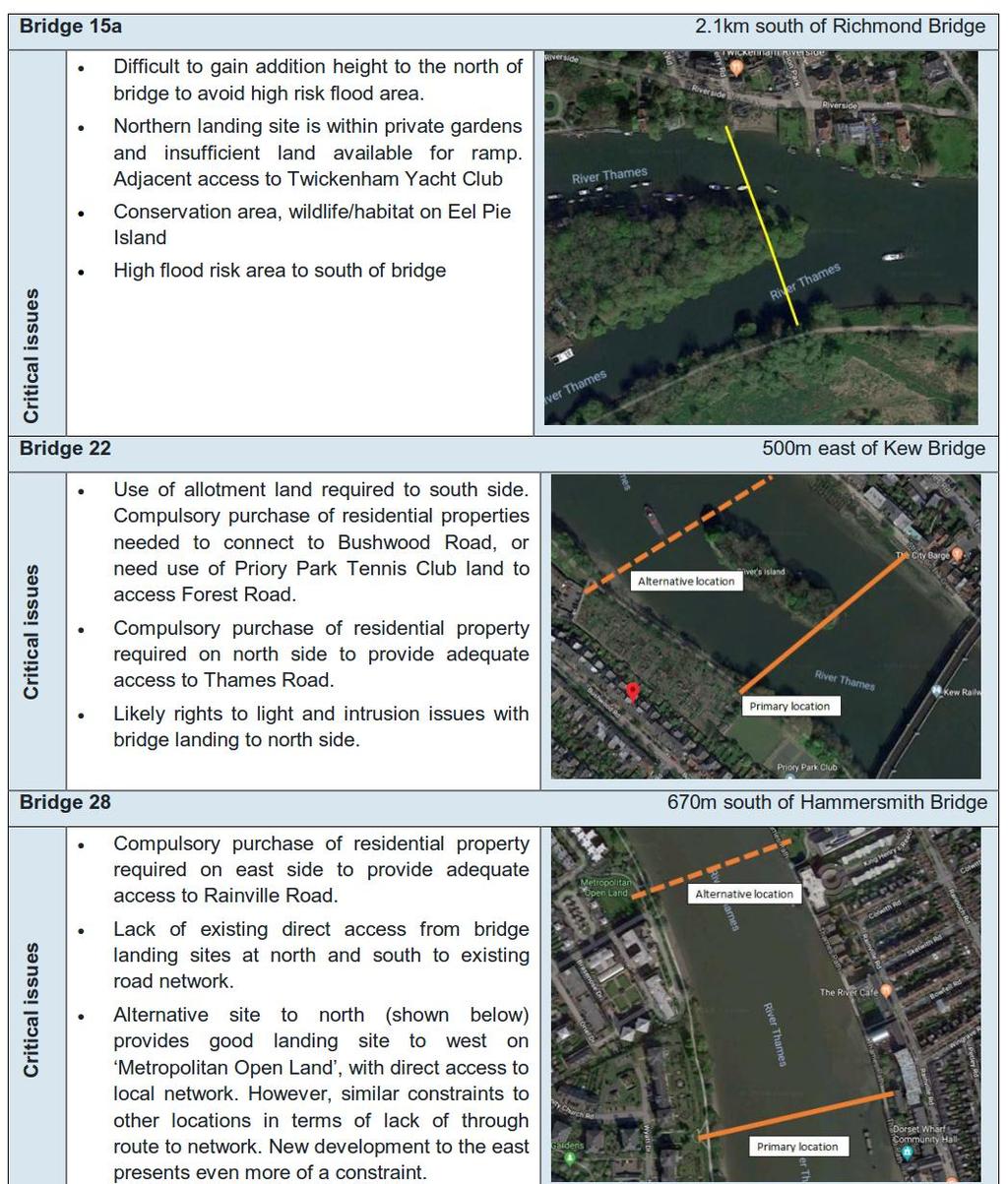
27 LANDING SITE CONSIDERATIONS BRIDGE 15 Figure 8.9 Bridge 15 location View east to Ham Street car park Bridge will connect to existing road on northside of Orleans Gardens Figure 8.10 Bridge 15 location View east to Orleans Gardens


28 LANDING SITE CONSIDERATIONS BRIDGE 15 Figure 8.8 Bridge15 landing site considerations


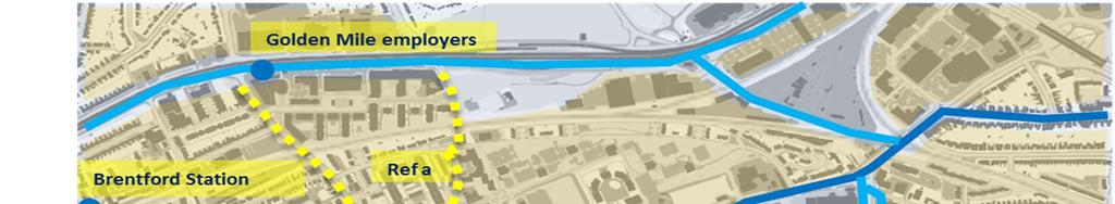
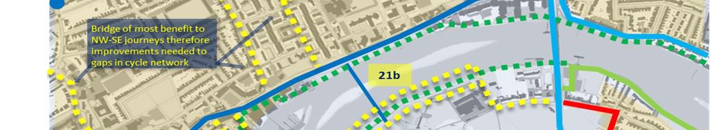
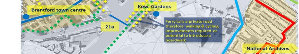
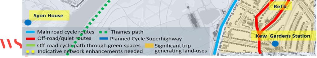
29 LANDING SITE CONSIDERATIONS BRIDGE 21A & 21B Figure 8.12 Bridge 21a location View west to Ferry Wharf View north towards Kew Bridge View west to Brentford Ait View south to Kew Gardens car park


30 LANDING SITE CONSIDERATIONS BRIDGE 21A & 21B Figure 8.11 Bridge21a and 21b landing site considerations

31 LANDING SITE CONSIDERATIONS SUMMARY

32 LANDING SITE CONSIDERATIONS SUMMARY
33 LANDING SITE ASSESSMENT Ref Landing Site Considerations - Key Criteria for Stage 2 Review Table 8.3 Landing site assessment Criteria Scoring Bridges RED AMBER GREEN 10c a 21b Comments 1 Land ownership Not publicly accessible 3 Planning areas Over approved planning areas. Public space or a public accessible space one side of bridge 4 Green Spaces N/A Not a green space Over planning areas with pending decision or in planning areas where the landing site could be incorporated into design. Public space or a public accessible space both sides of bridge Outside any identified planning areas. Is a green space. Assumption that long term improvement can be made to green space and temporary impacts can be mitigated. 10c - north side private, 21a north side private, 21b south side private Site 21b - Waterman s Park, planning application in to redevelop for moorings 5 Protected vistas, heritage and aesthetic sensitivities Significant impact Minor impact No impact Thames Strategy (not a formal document) mentions vista from Richmond Hill close to protected vista.15 - Twickenham riverside contains historic residential buildings (not protected).21b aethetic sensitivities as close to protected vista. 6 Flood risk High Probability Medium Probability Low or Very Low probability 7 Moorings and other river uses (e.g. boatyards, rowing clubs) Signficant presence/historical significance Minor presence/historical significance 8 Topography Land drops away on egress fromlanding site at 5-6m say and level from river bank 9 Conservation areas/ Site of Nature Importance 10 Protected trees Both side of bridge within these areas Large number of protected trees One side of bridge within these areas Small number of protected trees No presence/historical significance Landing is high (say above 8m) and/or space to raise ground levels as integrated solution (e.g. parks). Neither side of bridge within these areas No protected trees 10c - moorings on all banks including island 21b - A315 to north of Watermans Park 3-4m above landing point 11 Proximity to residential buildings < 20m to residential building. Approx. 20m from building with windows facing landing point If: a) bridge landing arrives significantly far from a residential area (> 20m); b) is not a residential building; c) there are no windows facing the bridge landing. 12 Sevice Utilities 13 Listed building 14 Building of townscape merit N/A Requirement for improvements to 15 connecting links Potential for commercial activity and/or 16 development Assumed all landing sites have the same level of complexity. The footprint of a listed building forms part of landing site. Substantial improvements required Assumed all landing sites have the same level of complexity. Adjacent to listed building The footprint of a building of townscape merit forms part of landing site. Small-scale improvements required Assumed all landing sites have the same level of complexity. No listed building No building of townscape merit Very minor improvements required No potential Limited potential Significant potential 17 Potential for local area enhancement No potential Limited potential Significant potential 13- Substantial length new links required through Ham Lands e.g. café potential for 21a 21b north side, 15 northside
34 BUSINESS CASE ASSESSMENT Strategic Case


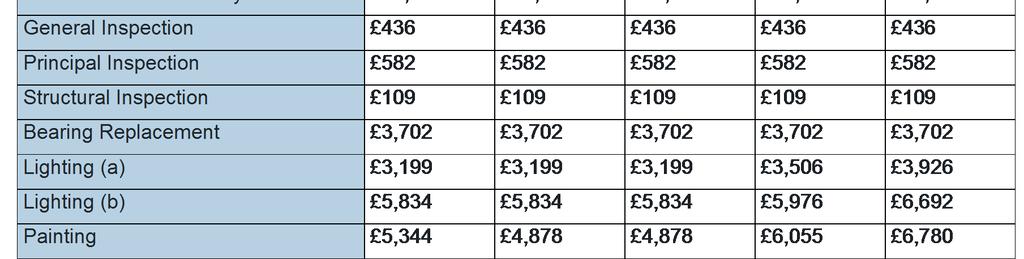
35 BUSINESS CASE ASSESSMENT - COSTS
36 BUSINESS CASE ASSESSMENT - BENEFITS Quantified Benefits The following impacts of the bridge have been quantified and valued: Journey time savings Safety Ambience Health Emissions Absenteeism Decongestion Net Benefit to Passengers and Private Sector (including tax impacts) PV 1a. User Benefit - Time Saving 27,910,527 1b. User Benefit - Ambience 52,781 1c. User Benefit - Absenteeism 810,105 1d. User Benefit - Health Benefit 613, Revenue Benefit 3. Non User Benefits - Road Decongestion 2,657, Non User Benefits - Noise, Air Quality, Greenhouse Gases, Accident Benefits and Others 118, Indirect Taxation -76,407 Sub-Total (a) 32,086,300 Costs to Government (broad transport budget) 1. Grant (Capital) Costs 8,631, Operating and Maintenance Costs 1,511,700 Sub-Total (b) 10,143,651 Net Present Value (NPV) (a-b) 21,942,649 Benefit Cost Ratio to Government (BCR) (a/b) 3.16 Wider Economic Benefits Impact (c) Net Present Value including Wider Economic Benefits (NPV) (a+c-b) 21,942,649 Benefit Cost Ratio to Government (BCR) including Wider Economic Benefits ((a+c)/b) 3.16 Bridge Modification to Calculated Demand -20% -10% -5% Central +5% +10% +20% 10c a b

37 APPRAISAL SUMMARY Summary of bridge features and outputs


38 APPRAISAL SUMMARY Impacts assessment Achieving project objectives

39 APPRAISAL SUMMARY Delivery risks Recommendations
ARCADIAN THAMES WALKS
 Thames Landcape Strategy Hampton to Kew Annual Review 2008 15 ARCADIAN THAMES WALKS Below is one of the TLS Arcadian Thames Walks that will lead you around the fascinating River Thames on your doorstep.
Shift Rapid Transit Public Participation Meeting May 3, 2017
 Shift Rapid Transit Public Participation Meeting May 3, 2017 Shift Rapid Transit Initiative Largest infrastructure project in the city s history. Rapid Transit initiative will transform London s public
Public realm strategy
 Mayor of London 71 new pedestrian bridge across the river strategic green links to the river Chapter 7 Public realm strategy new linear park improved road environment improved river walk indicative masterplan
North Somerset Council Local Development Framework
 North Somerset Council Local Development Framework Sites and Policies Development Plan Document Evidence Paper Re-opening Portishead Railway Line and Options for the Location of Portishead Railway Station
Response to the London Bridge Area Vision and Site Allocations within the New Southwark Plan
 1 Melior Place London SE1 3SZ 020 7407 4701 teamlondonbridge.co.uk info@teamlondonbridge.co.uk 28 April 2017 Response to the London Bridge Area Vision and Site Allocations within the New Southwark Plan
Victoria Bridge Municipal Class EA Civic Works Committee
 Municipal Class EA John Pucchio, P. Eng., Project Manager June 19 2018 Introduction Existing Conditions Municipal Class EA Proposed Bridge Proposed Road Reconstruction Proposed Improvements Construction
GLEN ROAD PEDESTRIAN BRIDGE ENVIRONMENTAL ASSESSMENT STUDY PUBLIC INFORMATION CENTRE #2 OCTOBER 24, 2017
 GLEN ROAD PEDESTRIAN BRIDGE ENVIRONMENTAL ASSESSMENT STUDY PUBLIC INFORMATION CENTRE #2 OCTOBER 24, 2017 Glen Road Pedestrian Bridge Class Environmental Assessment 1 WELCOME! Welcome to the second Public
The Duke s River: Revitalising the link between the River Crane and the River Thames
 The Duke s River: Revitalising the link between the River Crane and the River Thames The project The eastern section of the Duke of Northumberland s River runs for approximately four kilometres, from where
Whitchurch Bridge Approach Road
 Approach Road Addendum to Report for Highway Widening On behalf of The Company Project Ref: 36466/ Rev: 0 Date: March 2017 Office Address: Caversham Bridge House, Waterman Place, Reading, Berkshire RG1
Golden Mile Transport Group THE GOLDEN MILE A BRIGHT FUTURE
 Golden Mile Transport Group THE GOLDEN MILE A BRIGHT FUTURE STUDY AREA South Ealing Osterly Park Chiswick Brentford Kew 85 Hectares/2.25 Miles GOLDEN MILE Stakeholder Workshop Dec 10th Format The first
13. London Bridge London Bridge Area Vision
 13. 13.1. Area Vision 13.1.1. is: A globally significant central London business district which is home to international business headquarters; Internationally renowned for its prominent riverfront location
Chapter 10 Route window W17 Middlegreen Road, St Mary s Road and Trenches bridges. Transport for London
 Chapter 10 Route window W17 Middlegreen Road, St Mary s Road and Trenches bridges Transport for London MIDDLEGREEN ROAD, ST MARY S ROAD AND TRENCHES BRIDGES 10 Route window W17 Middlegreen Road, St Mary
APPENDIX 1: SITE ALLOCATIONS. GREAT WEST CORRIDOR Local Plan Review
 APPENDIX 1: SITE ALLOCATIONS GREAT WEST CORRIDOR Local Plan Review 1000 Great West Road Ward: Brentford Address: 1000 Great West Road Brentford TW8 9DW Source: Call for sites 2016 PTAL: 2 Site Area (ha):
Vision for East Cowes
 Vision for East Cowes A better East Cowes for now and the future The East Cowes Regeneration project is a major regeneration scheme on the Isle of Wight. It will create a vibrant community with a long-term
Peckham Peckham Area Vision Map
 Area Vision Map PNAAP13 PNAAP8 Sumner Road Surrey Canal Walk Bird in Bush Park Key: NSP Site Allocations PNAAP Allocations Greenspace Low Line Cycle Network Primary Shopping Areas Square Surrey Canal Walk
16. Peckham Peckham Area Vision
 16. 16.1. Area Vision 16.1.1. is: A lively town centre providing a range of daytime and night time activities on Rye Lane including a Library, a Leisure Centre and many independent retailers which specialise
St. Clair Avenue West Area Transportation Master Plan
 1 (Between Keele Street and Old Weston Road) Public Information Centre 1 December 2, 2015 2 Welcome Welcome to the first Public Information Centre for the St. Clair Avenue West Area. The panels will present
Wallingford Neighbourhood Plan
 Wallingford Neighbourhood Plan Introduction What is neighbourhood planning? Neighbourhood planning was introduced by the Localism Act 2011 to give local people more influence over how development comes
Welcome to the Oakridge Centre Open House
 Welcome to the Oakridge Centre Open House Why is the City hosting this event? This open house is to inform you of a rezoning application submitted to the City of Vancouver to amend the existing CD-1 (Comprehensive
Making the case for Sustainable Transport Project Potential
 Making the case for Sustainable Transport Project Potential The Structural Investment Fund (SIF) Strategy for Greater Lincolnshire identifies the barriers to growth identified by having poor transport
heuston gateway: sections heuston gateway: regeneration strategy and development framework plan
 B B1 A B1 B C A heuston gateway: sections B B1 C 117 4.3.3 Zoning The station is the central hub of the area and this function must be preserved and developed. However large areas of the Heuston Station
Design Review Report Llanfoist to Abergavenny Footbridge DCFW Ref: 118 Meeting of 10th August 2016
 Design Review Report Llanfoist to Abergavenny Footbridge DCFW Ref: 118 Meeting of 10 th August 2016 Declarations of Interest Panel members, observers and other relevant parties are required to declare
Date: 23 January Grange and Riverside Ward. Deputy Chief Executive
 Item No. 8. Classification: Open Date: 23 January 2012 Meeting Name: Bermondsey Community Council Report title: Ward(s) or groups affected: From: Section 106 Release Report for the provisional allocation
London Bridge London Bridge Area Vision Map
 Area Vision Map Borough Market Southwark Cathedral NSP54 Hay s Galleria Key: NSP Site Allocations Greenspace Low Line Thames Path Cycle Network Primary Shopping Areas Borough High Street Tube Station NSP51
Rotherhithe Rotherhithe Area Vision Map
 Area Vision Map CWAAP1 Improved pedestrian and cycle links to the wider area Improved link from town centre to River Thames and docks CWAAP2 Brunel Museum NSP79 CWAAP3 Proposed Thames Crossing Station
OTHER STATUTORY AND NON-STATUTORY BODIES
 Project, a floating barge converted as a study centre for use by schools and other organisations, and the Environment Centre in Richmond town centre. Hounslow has its Brentford Initiative and a particular
Evesham 7. Reasoned Justification
 95 Reasoned Justification 7.1 Evesham is situated within the Vale of Evesham and has an estimated population of 22,800 (2009 Mid-Term Population Estimates). As a main town it provides a wide range of services
Evaluation Criteria. Detailed Evaluation Criteria
 Evaluation Criteria Detailed Evaluation Criteria Community Well-being A safe and socially inclusive service that improves access to key community destinations and provides transportation choices for Calgarians.
Welcome to our public exhibition on London Square s plans to redevelop the B&Q site on Smugglers Way. from Monday 10th October 2016.
 WELCOME Welcome to our public exhibition on London Square s plans to redevelop the B&Q site on Smugglers Way. Aerial view of existing site Our plans are for a mixed use development which will provide new
 CGI looking up Market Street towards the Church of Christ the Saviour Welcome St George would like to welcome you to our public exhibition about the progress made at Dickens Yard and our future plans.
Site Allocations. REG 107 Appendix 1 Part B. february 2014
 Site Allocations Proposed submission local plan REG 107 Appendix 1 Part B february 2014 site allocations overview map of proposed site allocations overview map to be inserted prior to consultation 2 site
Longbridge Town Centre Phase 2 Planning Application
 Longbridge Town Centre Phase 2 Planning Application Non-Technical Summary of the Environmental Statement December 2013 Introduction A full application for Planning Permission has been submitted to Birmingham
5. Bankside and The Borough 5.1. Bankside and The Borough Area Vision
 5. 5.1. Area Vision 5.1.1. are: A globally significant central London business district which is home to international business headquarters; At the heart of the commercial and cultural life of the capital
Our City Centre is a vibrant, creative and welcoming destination, with a modern business, cultural, shopping, leisure and residential offer
 3. Sheffield in 2034 Our City sits at the heart of a strong, distinctive and internationally successful City Region economy which supports innovation and enterprise Our City Centre is a vibrant, creative
Tall Buildings Strategy
 Chapter 8 Tall Building Strategy Mayor of London 115 existing & consented tall buildings effect on views of palace of westminster Chapter 8 Tall Buildings Strategy tall building cluster upto 150m with
here today Public exhibition
 Public exhibition here today Find out more about Central England Co-operative and Hawkstone Vale Developments Ltd s redevelopment proposal to bring new retail and community facilities to Wilnecote. The
Integrated Urban Development. April Reflections from the NZPI Study Tour of Portland, Seattle and Vancouver
 Integrated Urban Development April 2009 Reflections from the NZPI Study Tour of Portland, Seattle and Vancouver Integrated Urban Development Urban Growth Management Transportation Transit Orientated Mixed
Kew WHS and the challenges of the regeneration of Brentford
 Kew WHS and the challenges of the regeneration of Brentford Andrew Williams, Director of Estates & Capital Development Georgina Darroch, World Heritage Site Coordinator The Property The Royal Botanic
STATEMENT OF OBJECTION TO THE PROPOSED DEVELOPMENT OF LAND AT CHURCH CLIFF DRIVE FILEY
 STATEMENT OF OBJECTION TO THE PROPOSED DEVELOPMENT OF LAND AT CHURCH CLIFF DRIVE FILEY You will be aware that Scarborough borough council have adopted a new local plan that includes land at Church Cliff
Meridian Water Phase 1 Application
 Meridian Water Phase 1 Application MW11 Environmental Statement Non-Technical Summary London Borough of Enfield March 2016 Contents 1 Introduction 1 2 The proposed development 2 3 Evolution of the proposed
Can town centres retain the social heart of our communities?
 Urban Design Group Solent - June 2013 Can town centres retain the social heart of our communities? Examples of strategic masterplanning and public realm design to re-invent urban centres Peter Frankum
Taking forward the All London Green Grid
 Taking forward the All London Green Grid Foreword Earlier this year, the Mayor published the All London Green Grid Supplementary Planning Guidance to the London Plan which set the vision, and framework,
Scottish Natural Heritage. Better places for people and nature
 Scottish Natural Heritage Better places for people and nature Contents Summary... 3 SNH approach... 5 Place-making in policy and practice... 6 Developing the contribution of the natural heritage to place-making...
6. Bermondsey 6.1. Bermondsey Area Vision
 6. 6.1. Area Vision 6.1.1. is: An inner-london neighbourhood characterised by modest worker ho associated with the historic Rotherhithe docks and local manufacturing industries such as biscuits, jam, vinegar
Overview Report. Proposed Development
 Overview Report Proposed Development the construction of a 1km cycle/pedestrian trail including a new footbridge, new car park and entrance road at Drumshanbo Lock and a new pedestrian/cycle road crossing,
Valuing the social benefits of local infrastructure in Workington, ibuild briefing paper 9
 Valuing the social benefits of local infrastructure in Workington, ibuild briefing paper 9 March, 2015 Arthur Affleck ibuild, Newcastle University Jane Gibbon Newcastle University Business School The paper
NERVIÓN LINEAR PARK GREEN WAY, SALBIO STATION-OLAKO SECTION PROVINCIAL COUNCIL OF ALAVA.
 NERVIÓN LINEAR PARK GREEN WAY, SALBIO STATION-OLAKO SECTION PROVINCIAL COUNCIL OF ALAVA. Año 2017 GOOD PRACTICE PROPOSAL: NERVIÓN LINEAR PARK GREEN WAY, SALBIO STATION-OLAKO SECTION, CARRIED OUT BY THE
Chapter 9 Route window W18 Slough station. Transport for London
 Chapter 9 Route window W18 Slough station Transport SLOUGH STATION 9 Route window W18 Slough station 9.6 Wexham Road bridge worksite north; and Wexham Road bridge worksite south. Uxbridge Road bridge
Bridge Type Assessment and Evaluation
 16M-01410-01 (3216026) Glen Road Pedestrian Bridge EA Study Bridge Type Assessment and Evaluation Factor Group/Criteria Alternative 1: Steel girder with two inclined steel legs Alternative 2: Steel girder
Chapter 03 Planning framework
 Vauxhall Nine Elms Battersea Opportunity Area Planning Framework Chapter 03 Planning framework Mayor of London 25 preferred option - 16,000 residential units 20,000-25,000 jobs northern line extension
Chapter 7 Route window W20 Dover Road and Leigh Road bridges. Transport for London
 Chapter 7 Route window W20 Dover Road and Leigh Road bridges Transport for London ROUTE WINDOW W20 7 Route window W20 Dover Road and Leigh Road bridges Transport for London 7.6 7.7 7.8 Baseline conditions
Horwood Map of London, Westminster & Southwark First edition
 Barratt London is developing plans in tandem with Southwark Council and TfL to transform the southern end of Blackfriars Road. The residential-led, mixed-use scheme will deliver new private and affordable
Workshop 3. City of Burlington Waterfront Hotel Planning Study. September 14, The Planning Partnership
 Workshop 3 City of Burlington Waterfront Hotel Planning Study September 14, 2017 The Planning Partnership The Waterfront Hotel Planning Study 01 The Brant & Lakeshore Planning Study will establish a Strategic
Welcome to our public exhibition
 About our development Welcome to our public exhibition This public exhibition gives you the opportunity to view and comment on our proposals to create a new residential development on land adjacent to
Notting Hill Housing & The Development Team
 Notting Hill Housing & The Development Team Welcome to Notting Hill Housing s first consultation event about the sites. Notting Hill is one of the most innovative housing associations in the UK and one
Appendix D: Locality Office panels
 Crest Nicholson Developments Ltd and Sainsbury s Proposed Redevelopment: East Street, Farnham Public Consultation Report Appendix D: Locality Office panels May 2008 Halogen New planning application Our
Creative co-design public realm project The Moorings, Thamesmead
 Tender Specification Creative co-design public realm project The Moorings, Thamesmead 1. Introduction Thamesmead is a community of 46,000 people in SE London, on the south bank of the River Thames, built
Hudson Group North America LLC
 Hudson Group North America LLC Mr. John Palmieri, Director Boston Redevelopment Authority One City Hall Square Boston, MA 02201 August 30, 2010 RE: 120 Kingston Street Development, Notice of Project Change
Christine Toner, Consultation Leader
 9. FAIRVIEW STREET FOOTBRIDGE REBUILD General Manager responsible: General Manager, City Environment Group, DDI 941-8608 Officer responsible: Unit Manager, Transport and Greenspace Author: Christine Toner,
Elephant and Castle. Elephant and Castle Area Vision Map. Elephant and Castle. 216 New Southwark Plan Proposed Submission Version NSP42 NSP49 NSP44
 Area Vision Map Lamberth North Station Waterloo Road Southwark Station NSP49 NSP43 Blackfriars Rd St George s Road Borough Road NSP48 Great Suffolk Street NSP42 NSP44 NSP45 Borough Station Newington Gardens
ROCHFORD LOCAL DEVELOPMENT FRAMEWORK: Sustainability Appraisal/ Strategic Environmental Assessment. Rochford Core Strategy Preferred Options Document
 ROCHFORD LOCAL DEVELOPMENT FRAMEWORK: Sustainability Appraisal/ Strategic Environmental Assessment Non Technical Summary Rochford Core Strategy Preferred Options Document October 2008 SUSTAINABILITY APPRAISAL
17A. Wind Microclimate
 17A. Wind Microclimate 17A.1 Introduction 17A.1.1 17A.1.2 17A.1.3 17A.1.4 This Chapter, which has been prepared by Waterman and BMT, provides further information with regard to the potential wind microclimate
WELCOME TO OPEN HOUSE TWO November 28, 2018
 Langstaff Road Weston Road to Highway 7 Class Environmental Assessment Study WELCOME TO OPEN HOUSE TWO November 28, 2018 Please sign in and join our mailing list Study Overview York Region is conducting
4 RESIDENTIAL ZONE. 4.1 Background
 4 RESIDENTIAL ZONE 4.1 Background The residential areas within the City are characterised by mainly lowrise dwellings sited on individual allotments. Past architectural styles, settlement patterns and
Town and Country Planning Act 1990 Section 79 and Town and Country Planning (Inquiries Procedure) (England) Rules 2000
 (England) Rules 2000") Town and Country Planning Act 1990 Section 79 and Town and Country Planning (Inquiries Procedure) (England) Rules 2000 Statement of Case of Royal Botanic Gardens, Kew Application by Starbones Ltd. Land
Town and Country Planning Act 1990 Section 79 and Town and Country Planning (Inquiries Procedure) (England) Rules 2000 Statement of Case of Royal Botanic Gardens, Kew Application by Starbones Ltd. Land
WINCHESTER TOWN 3.1 LOCATION, CHARACTERISTICS & SETTING
 WINCHESTER TOWN 3.1 LOCATION, CHARACTERISTICS & SETTING 3.1.1 The area referred to by the City Council, as Winchester Town, consists of the Winchester Wards plus the adjoining built up areas of Badger
A303 Stonehenge. Amesbury to Berwick Down Scheme Assessment Report Appendix D CSR and Policy Assessment. Volume 6
 A0 Stonehenge Amesbury to Berwick Down Scheme Assessment Report Appendix D CSR and Policy Assessment Volume 6 September 2017 Appendix D Client Scheme Requirements (CSRs) and Policy Assessment D.1 CSR Assessment
Welcome. Green Line LRT. Beltline Alignment Options. Stay engaged! Follow the Green Line story at calgary.ca/greenline
 Welcome Green Line LRT Beltline Alignment Options Stay engaged! Follow the Green Line story at calgary.ca/greenline Green Line LRT Why are we here? Our Challenge Determine the best alignment in the Beltline.
Welcome to this public consultation event for the proposed South Western Relief Road. Thank you for taking the time to come along.
 WELCOME Welcome to this public consultation event for the proposed South Western Relief Road. Thank you for taking the time to come along. The South Western Relief Road (SWRR) route is proposed in Stratford-on-Avon
Land use strategy. Chapter 4. high density mixed use. mixed use housing. limited intensification. market consolidation. industrial intensification
 Chapter 04 Land use strategy Mayor of London 31 high density mixed use mixed use housing Chapter 4 Land use strategy limited intensification market consolidation industrial intensification aerial image
The purpose of tonight s PIC is to:
 The purpose of tonight s PIC is to: Provide an overview of the work completed to date and a summary of the Class EA process being followed; Provide a summary of public input received so far, including
CITY OF LONDON LOCAL PLAN. January 2015
 CITY OF LONDON LOCAL PLAN January 2015 1 2 CITY OF LONDON LOCAL PLAN Adopted 15th January 2015 Philip Everett BSc., CEng, MICE Director of the Built Environment Department of the Built Environment, City
Page 1 of 19 URBAN DESIGN FRAMEWORK FOR BOLTON STREET WATERFORD
 Page 1 of 19 URBAN DESIGN FRAMEWORK FOR BOLTON STREET WATERFORD 1.0 Introduction: The relocation of the City Council stores and depot from Bolton Street creates an exciting opportunity for development
10. East Dulwich East Dulwich Area Vision
 10. 10.1. Area Vision 10.1.1. is: A predominantly residential area characterised by mostly medium density housing, including many family homes. Many parts of have retained historic character and it includes
COURTHOUSE CAMPUS BARNSLEY Executive Summary March 2010
 COURTHOUSE CAMPUS BARNSLEY Executive Summary March 2010 Estell Warren Cartwright Pickard Buro Happold King Sturge BWA Barnsley Metropolitan Borough Council introduction Courthouse Campus is the last major
HURSTPIERPOINT SAYERS COMMON PARISH COUNCIL
 HURSTPIERPOINT SAYERS COMMON PARISH OFFICE TRINITY ROAD HURSTPIERPOINT HASSOCKS WEST SUSSEX BN6 9UY TEL: 01273 833264 FAX: 01273 834976 E-MAIL: HURSTPIERPOINT.PC@BTINTERNET.COM WEB SITE: WWW.HURSTPIERPOINT-PC.ORG.UK
Keystone Business Park Precinct Structure Plan North East Industrial Precinct. Part 2 Design Principles
 Keystone Business Park Precinct Structure Plan North East Industrial Precinct Part 2 Design Principles Context Issues Services Landform Issues Geotech and contamination Ecology Traffic and access Issues
WELCOME GYPSY LANE. Wider Site Location plan. Proposals for the development of LAND OFF FOXLYDIATE LANE WEBHEATH. Proposals for the development of
 WELCOME The developers are preparing an outline planning application for a residential led development and need the community s views in order to develop the proposals further WHAT IS PROPOSED? A high
Energy Efficient Strategies for Urban Transportation Planning
 EinT2018 3 rd International Conference ENERGY in TRANSPORTATION 2018 Energy Efficient Strategies for Urban Transportation Planning Prof. Dr. Doaa M. El-Sherif, PhD, Arch. Email: doaa_elsherif@yahoo.com
Appendix A. Planning Processes. Introduction
 1 Planning Processes Introduction This appendix outlines a number of planning processes which are used in the Auckland Region to support the effective management of development in the region s rural and
Welcome. Who are we? The Site. ZM Land and Capital and Plutus Estates (WGC) Ltd. Metropolitan
 Ltd. Metropolitan") Welcome Welcome to today s exhibition regarding the former Shredded Wheat Factory. Please take a look at the information we have provided on these exhibition boards and speak with a member of the team,
Welcome Welcome to today s exhibition regarding the former Shredded Wheat Factory. Please take a look at the information we have provided on these exhibition boards and speak with a member of the team,
WELCOME TO THE PUBLIC INFORMATION CENTRE. Please Sign In
 WELCOME TO THE PUBLIC INFORMATION CENTRE Replacement of Oxtongue Lake Narrows Bridge & Oxtongue River Bridge, Highway 60 (G.W.P. 93-89-00 & G.W.P. 5550-04-00) Class Environmental Assessment (Group B) Please
LONDON BRIDGE STATION ENVIRONMENTAL STATEMENT NON-TECHNICAL SUMMARY
 LONDON BRIDGE STATION ENVIRONMENTAL STATEMENT NON-TECHNICAL SUMMARY June 2011 1 EXECUTIVE SUMMARY 2 INTRODUCTION CONTENTS Page 2.1 Introduction 4 2.2 The Site 4 3 THE DEVELOPMENT 3.1 What is it? 5 3.2
Place Brief. National Collections Facility (NCF site)
") Place Brief. National Collections Facility (NCF site) Contents 1.0 Purpose 2.0 Location and Proposal 3.0 Vision and Aim 4.0 Placemaking Principles 5.0 Conclusion Plan 1 Location Plan Plan 2 Placemaking
Place Brief. National Collections Facility (NCF site) Contents 1.0 Purpose 2.0 Location and Proposal 3.0 Vision and Aim 4.0 Placemaking Principles 5.0 Conclusion Plan 1 Location Plan Plan 2 Placemaking
Ipswich Issues and Options for the Ipswich Local Plan Review, August 2017, Public Consultation
 Ipswich Issues and Options for the Ipswich Local Plan Review, August 2017, Public Consultation Having reviewed the issues and options documents, the Society has made the following response: Part 1 Strategic
Site ref: AS06 Site Name or Address: Murreys Court, Agates Lane
 Site ref: AS06 Site Name or Address: Murreys Court, Agates Lane Proposed Land Use: Total Site Area (Ha): Housing 1.85 Ha Description: It is understood that the owner has no plans to dispose of the site
Public Meeting #3 May 9, 2009 MVVA Team
 Public Meeting #3 May 9, 2009 MVVA Team Welcome to the third Public Meeting for the Lower Don Lands Municipal Class Environmental Assessment (EA) Infrastructure Master Plan and Keating Channel Precinct
Commissioners Road West Realignment Environmental Assessment
 City of London Commissioners Road West Realignment Environmental Assessment Public Information Centre No. 1 March 30, 2017 Welcome to the Public Information Centre This first Public Information Centre
Purpose of Open House #3
 Public Meeting #3 May 9, 2009 MVVA Team Purpose of Open House #3 The main purpose of this Open House is to present and seek input on the: Evaluation of transportation and infrastructure design alternatives
WELCOME TO PUBLIC INFORMATION CENTRE #2. Please Sign In
 WELCOME TO PUBLIC INFORMATION CENTRE #2 Replacement of Oxtongue Lake Narrows Bridge & Oxtongue River Bridge, Highway 60 (G.W.P. 93-89-00 & G.W.P. 5550-04-00) Class Environmental Assessment (Group B) Please
Milburngate House Site, Durham City. Design and Development Brief for Consultation. Summary for Public Consultation
 Milburngate House Site, Durham City Design and Development Brief for Consultation Summary for Public Consultation October 2011 Introduction to the Brief Background The Milburngate House site is a large
Eastbourne Borough Council. Summary Proof of Evidence Of Barry John Cansfield BA (Hons), BTP, MRTPI on behalf of PRLP
, BTP, MRTPI on behalf of PRLP") Eastbourne Borough Council (Arndale Centre and surrounding Land at Terminus Road, Sutton Road and Ashford Road) (Compulsory Purchase Order 2015) Section 226 (1)(a) of the Town and Country Planning Act
Eastbourne Borough Council (Arndale Centre and surrounding Land at Terminus Road, Sutton Road and Ashford Road) (Compulsory Purchase Order 2015) Section 226 (1)(a) of the Town and Country Planning Act
WELCOME. Thanks for visiting Hadley Property Group s exhibition on its initial plans to redevelop land at Bath Road in Totterdown.
 WELCOME Thanks for visiting Hadley Property Group s exhibition on its initial plans to redevelop land at Bath Road in Totterdown. This exhibition is to inform you about our plans to transform the disused
Droitwich Spa 6. Reasoned Justification
 87 Droitwich Spa 6 Reasoned Justification 6.1 Droitwich Spa is identified in the settlement hierarchy (Policy SWDP1) as a main town being the largest settlement in Wychavon District with an estimated population
Welcome to our latest public exhibition to show the final proposals prior to submission for the Homebase site on Manor Road.
 Welcome 01 Welcome to our latest public exhibition to show the final proposals prior to submission for the Homebase site on Manor Road. The purpose of this exhibition is to display the scheme in more detail
Victoria Street Pedestrian Bridge
 Township of Centre Wellington Victoria Street Pedestrian Bridge Class Environmental Assessment County of Wellington & Township of Centre Wellington Badley Bridge Replacement/Rehabilitation (County of Wellington),
BROMLEY-BY-BOW SUPPLEMENTARY PLANNING DOCUMENT (ADOPTED - APRIL 2017)
") BROMLEY-BY-BOW SUPPLEMENTARY PLANNING DOCUMENT (ADOPTED - APRIL 2017) CONTENTS 1. Introduction 4 PART A: SETTING THE SCENE 6 2. Background, purpose and structure of this SPD 6 3. Planning Policy Framework
BROMLEY-BY-BOW SUPPLEMENTARY PLANNING DOCUMENT (ADOPTED - APRIL 2017) CONTENTS 1. Introduction 4 PART A: SETTING THE SCENE 6 2. Background, purpose and structure of this SPD 6 3. Planning Policy Framework
Sheffield Victoria Station Development Prospectus January 2014
 6 Billion extra GVA growth for Sheffield City Region s economy Sheffield Victoria Station Development Prospectus January 2014 Document produced by Sheffield City Council Introduction The construction of
Rochford District Council Allocations Development Plan Document: Discussion and Consultation Document Sustainability Appraisal
 Option SWH1 Balanced Communities Option SWH1 1 To ensure the delivery of high quality sustainable communities where people want to live and work Will it ensure the phasing of infrastructure, including
GLEN ROAD PEDESTRIAN BRIDGE ENVIRONMENTAL ASSESSMENT STUDY PUBLIC INFORMATION CENTRE #1 SEPTEMBER 28, 2016
 GLEN ROAD PEDESTRIAN BRIDGE ENVIRONMENTAL ASSESSMENT STUDY PUBLIC INFORMATION CENTRE #1 SEPTEMBER 28, 2016 Glen Road Pedestrian Bridge Class Environmental Assessment WELCOME! Welcome to the first Public