ARCHAEOLOGICAL DESK- BASED ASSESSMENT MAYLANDS GATEWAY HEMEL HEMPSTEAD HERTFORDSHIRE
|
|
|
- Norman Dorsey
- 5 years ago
- Views:
Transcription

1 ARCHAEOLOGICAL DESK- BASED ASSESSMENT MAYLANDS GATEWAY HEMEL HEMPSTEAD HERTFORDSHIRE JUNE 2016
2 Local Planning Authority: Dacorum Borough Council Site centred at: TL Author: Paul Clark BA MCIfA Approved by: Simon Mortimer MA( Oxon ) MCIfA Report Status: FINAL CgMs Limited No part of this report is to be copied in any way without prior written consent. Every effort is made to provide detailed and accurate information, however, CgMs Limited cannot be held responsible for errors or inaccuracies within this report. Issue Date: June 2016 CgMs Ref: PGC/SM/21374/02 Ordnance Survey maps reproduced with the sanction of the controller of HM Stationery Office. Licence No: AL
3 Contents Executive Summary 1.0 Introduction and Scope of Study 2.0 Planning Background and Development Plan Framework 3.0 Geology and Topography 4.0 Archaeological and Historical Background, including Assessment of Significance 5.0 Site Conditions, the Proposed Development and Impact on Heritage Assets 6.0 Conclusions Sources Consulted Appendix 1: Gazetteer of Designated Heritage Assets and HER Data List of Illustrations Figure 1 Site location Figure 2 Designated Heritage Assets Figure 3 HER Monuments Figure 4 HER Events Figure 5 LIDAR Plot Figure 6 Geophysical Survey Figure 7 Geotechnical test pit location plan Figure 8 Trial Trench location plan Figure Ordnance Survey Preliminary Drawing Figure Tithe Map Figure Ordnance Survey Figure Ordnance Survey Figure Ordnance Survey Figure Ordnance Survey Figure 15 Archaeological potential shown on cut/fill plan List of Plates Plate 1 View west across north-eastern part of site Plate 2 View north-west across north-eastern part of site Plate 3 View south-west across western part of site Plate 4 View west along northern site boundary Plate 5 View south along terrace in western part of site Plate 6 View south across former building in western part of site Plate 7 View north-east across former running track Plate 8 View south-east across former caravan park CgMs Ltd 1 PGC/SM/21374/02
4 Executive Summary This desk-based assessment considers hectares of land proposed for development at. The assessment provides a description of archaeological assets potentially affected by the development of the site and addresses the information requirements of Government s National Planning Policy Framework, particularly paragraph 128 and Policy CS27 of the Dacorum Borough Council s Core Strategy. There are no designated heritage assets or non-designated heritage assets on the proposed development site and there will be no impact upon any designated heritage assets or their settings within the wider area. The northern part of the site is located within an Area of Archaeological Significance associated with a Scheduled Ancient Monument located to the north of the site within the Hales Park area. A separate report has been prepared giving consideration to built heritage assets. This concludes that there are no impacts on the setting of any designated built heritage assets outside of the site. Following early pre-application discussions with Alison Tinniswood, Historic Environment Advisor at Hertfordshire County Council, an iterative programme of archaeological work has been undertaken within the site, with Written Schemes of Investigation for each element agreed with the LPA, comprising cart-based detailed geophysical survey; archaeological observation and recording of geotechnical trial pits and trial trenching. This has confirmed that whilst the site has been extensively terraced in the recent past there are zones that retain archaeological features. These are focused within the centre and north-western extents of the site, where there is evidence for Roman activity, including a corn drier and associated pits and ditches. A single Iron Age ditch was also identified. It has been agreed with the Historic Environment Advisor that the heritage interest in the site can be safe-guarded by an appropriately worded archaeological condition. This will secure the implementation of a programme of archaeological excavation, recording and subsequent offsite assessment, analysis and reporting of any significant deposits that cannot be preserved in situ. Trenching has not yet been possible in the area of the stables or former tennis court and there will be a requirement for further evaluative work (and potentially mitigation) in these areas. The conditioned works will mitigate the effects of development and the archaeological interest in the site will be preserved by record. CgMs Ltd 2 PGC/SM/21374/02
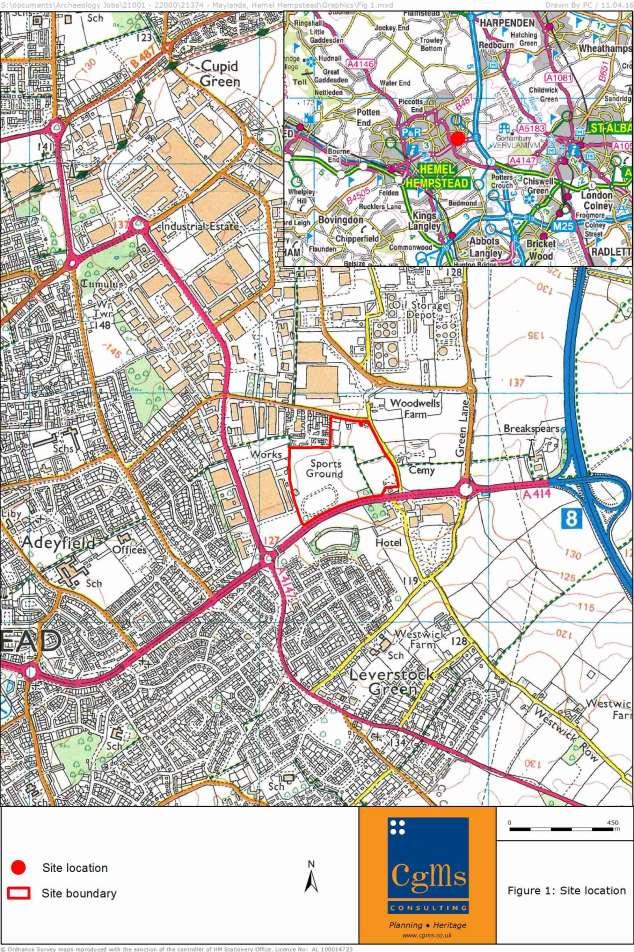
5 1.0 INTRODUCTION AND SCOPE OF STUDY 1.1 This desk-based assessment of land at Maylands Gateway, Hemel Hempstead, Hertfordshire has been researched and prepared by CgMs Consulting on behalf of Prologis. 1.2 The site, also referred to as the study site, is located on the eastern edge of Hemel Hempstead, comprising approximately hectares of land centred at National Grid Reference TL (Figure 1). The site is bounded to the south by Breakspear Way, to the east by Buncefield Lane, to the north by Wood Lane End and residential properties and to the west by commercial properties. 1.3 This assessment has been prepared in compliance with the National Planning Policy Framework, to identify and provide a description of the significance of archaeological assets on the site and the likely effects of future development. This study concentrates on identifying any archaeological interest in the site and assessing the potential impact of development on the archaeological significance of any identified assets. A separate report has been prepared giving consideration to built heritage assets (CgMs 2016). This report concludes that there are no impacts on the setting of any designated built heritage assets outside of the site. 1.4 The assessment comprises an examination of evidence in the Hertfordshire Historic Environment Record (HER), Hertfordshire Archives and Local Studies, and online resources. It also incorporates the results of a geophysical survey of the site, undertaken in January 2016, the archaeological monitoring of geotechnical test pits in February 2016 and an archaeological trial trench evaluation, undertaken in March and April Information regarding Scheduled Monuments, Registered Parks and Gardens, Registered Battlefields and Listed Buildings was obtained from the Hertfordshire HER and Historic England s National Heritage List for England. Information on Conservation Areas was sought from Dacorum Borough Council. The assessment incorporates published and unpublished material, and charts historic land-use through a map regression exercise. A site inspection for this report was undertaken on 14th January 2016, and subsequent monitoring meetings during the monitoring of the geotechnical test pits and the trial trenching were held on 24th March and 5th April respectively. 1.6 The study provides an assessment of the archaeological potential of the site and the significance of any archaeological assets within and around the site. As a result, the assessment enables relevant parties to identify and assess the impact of the proposed development and identify any necessary mitigation measures. CgMs Ltd 3 PGC/SM/21374/02
6 2.0 PLANNING BACKGROUND AND DEVELOPMENT PLAN FRAMEWORK 2.1 In considering any planning application for development, the local planning authority will be guided by the policy framework set by government planning policy, by current Development Plan policy and by other material considerations. National Planning Policy Framework 2.2 In 2012, the Government published the National Planning Policy Framework (NPPF), which replaced previous national policy relating to heritage and archaeology Section 12 of the NPPF, entitled Conserving and enhancing the historic environment provides guidance for planning authorities, property owners, developers and others on the conservation and investigation of heritage assets. Overall, the objectives of Section 12 of the NPPF can be summarised as seeking the: Delivery of sustainable development Understanding the wider social, cultural, economic and environmental benefits brought by the conservation of the historic environment, and Conservation of England's heritage assets in a manner appropriate to their significance Section 12 of the NPPF recognises that intelligently managed change may sometimes be necessary if heritage assets are to be maintained for the long term. Paragraph 128 states that planning decisions should be based on the significance of the heritage asset, and that the level of detail supplied by an applicant should be proportionate to the importance of the asset and should be no more than sufficient to review the potential impact of the proposal upon the significance of that asset Heritage Assets are defined in Annex 2 of the NPPF as: a building, monument, site, place, area or landscape positively identified as having a degree of significance meriting consideration in planning decisions, because of its heritage interest. They include designated heritage assets (as defined in the NPPF) and assets identified by the local planning authority during the process of decision-making or through the plan-making process Annex 2 also defines Archaeological Interest as a heritage asset which holds or potentially could hold, evidence of past human activity worthy of expert investigation at some point. Heritage assets with archaeological interest are the primary source of evidence about the substance and evolution of places, and of the people and cultures that made them. CgMs Ltd 4 PGC/SM/21374/02
7 2.2.5 A Designated Heritage Asset comprises a World Heritage Site, Scheduled Monument, Listed Building, Protected Wreck Site, Registered Park and Garden, Registered Battlefield or Conservation Area Significance is defined as: The value of a heritage asset to this and future generations because of its heritage interest. This interest may be archaeological, architectural, artistic or historic. Significance derives not only from a heritage asset s physical presence, but also from its setting In short, government policy provides a framework which: Protects nationally important designated Heritage Assets (which include World Heritage Sites, Scheduled Ancient Monuments, Listed Buildings, Protected Wreck Sites, Registered Parks and Gardens, Registered Battlefields or Conservation Areas) Protects the settings of such designations In appropriate circumstances seeks adequate information (from desk based assessment and field evaluation where necessary) to enable informed decisions Provides for the excavation and investigation of sites not significant enough to merit in-situ preservation. Planning Practice Guidance 2.3 The NPPG is a web-based resource which is to be used in conjunction with the NPPF. It is aimed at planning professionals and prescribes best practice within the planning sector. The relevant section is entitled Conserving and enhancing the historic environment. The guidance given in this section is effectively a condensed version of the PPS5 Practice Guide and sets out the best practice to applying government policy in the NPPF. Local Plan 2.4 Dacorum Borough Council s Core Strategy was adopted on 25 September The policy relating to heritage in the Core Strategy is CS27.; POLICY CS27: Quality of the Historic Environment All development will favour the conservation of heritage assets. The integrity, setting and distinctiveness of designated and undesignated heritage assets will be protected, conserved and if appropriate enhanced. Development will positively conserve and enhance the appearance and character of conservation areas. Negative features and problems identified in conservation area appraisals will be ameliorated or removed. Features of known or potential archaeological interest will be surveyed, recorded and wherever possible retained. Supplementary planning documents will provide further guidance. CgMs Ltd 5 PGC/SM/21374/02
8 2.5 Therefore in considering the archaeological implications of the proposed planning application for development, the local planning authority will be guided by the policy framework set by government (NPPF), planning practice guidance (NPPG), and Policy CS27 of the Dacorum Borough Council Core Strategy. 2.6 Dacorum Borough Council produced a Development Brief for Maylands Gateway in May The document identifies a cluster of sites, which includes the HCA ownership, as being suitable for commercial, mixed use development. CgMs Ltd 6 PGC/SM/21374/02
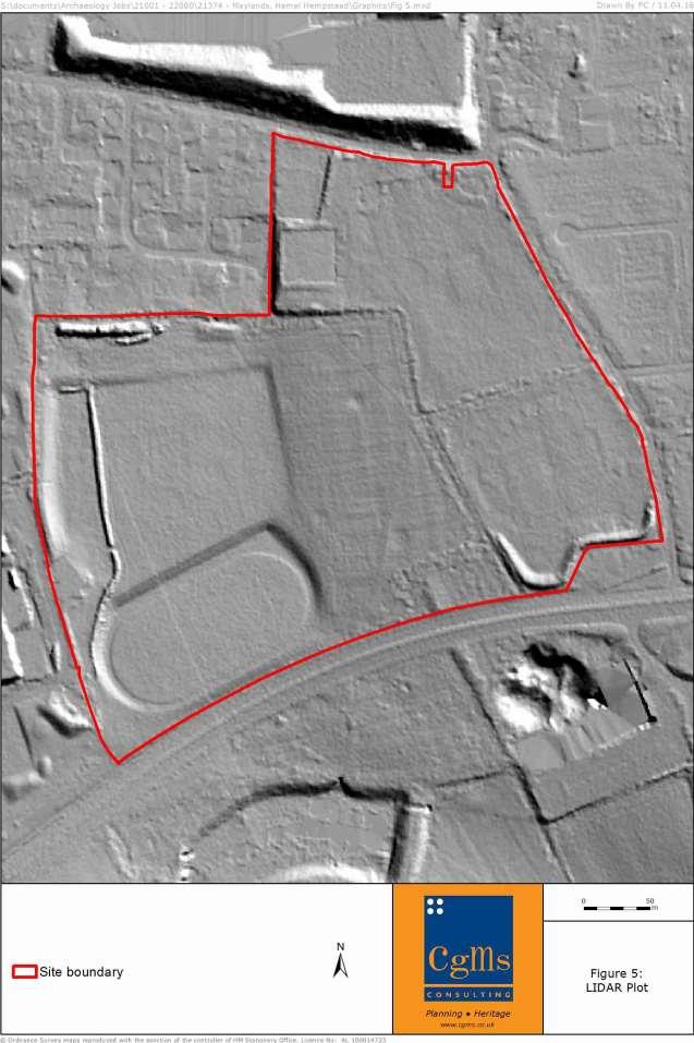
9 3.0 GEOLOGY AND TOPOGRAPHY 3.1 Geology The British Geological Survey (BGS) 1:50,000 records the solid geology of the northern part of the site as clay, silt and sand of the Lambeth Group, and chalk belonging to the Lewes Nodular Chalk Formation/Seaford Chalk Formation across the southern part of the site This is overlain by superficial deposits of clay, silt, sand and gravel belonging to the Clay-with-Flints Formation across most of the site, with no superficial deposits recorded for the north-eastern and north-western corners, and a portion of the southern part of the site. ( The trench evaluation (Albion Archaeology 2016b) identified made ground of up to 1.5m in depth, in 12 of the trenches excavated. The distribution of the majority of the trenches containing made ground indicated that it had been used to fill a dry valley (visible in the northern hedged boundary of the site). As the made ground had been used to level the site, it was thickest over the deepest part of the dry valley, which was aligned north/south and was around 150m wide Across the rest of the site the topsoil comprised m of friable dark grey-black clay-silt, overlying subsoil (only present where no terracing had taken place), comprising m of friable mid orange-brown clay-silt. 3.2 Topography The study site is located to the east of Hemel Hempstead, with the eastern part of the site on a gently south-west facing slope. The western part of the site has been terraced to form a playing field and running track (Figure 5) The site slopes from 137m AOD in the north-eastern corner to 128m at the southern boundary. The running track is at 126.5m AOD. CgMs Ltd 7 PGC/SM/21374/02
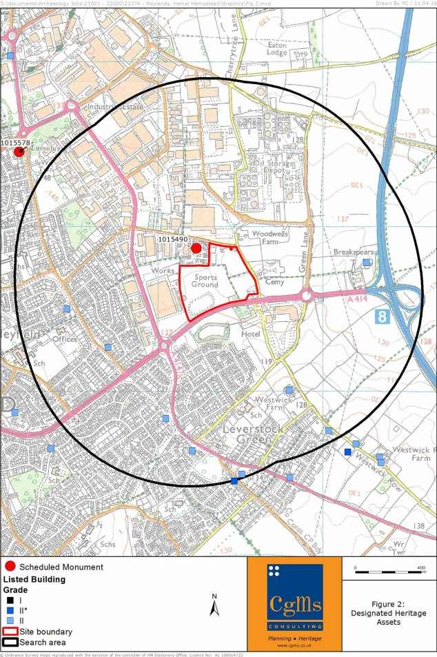
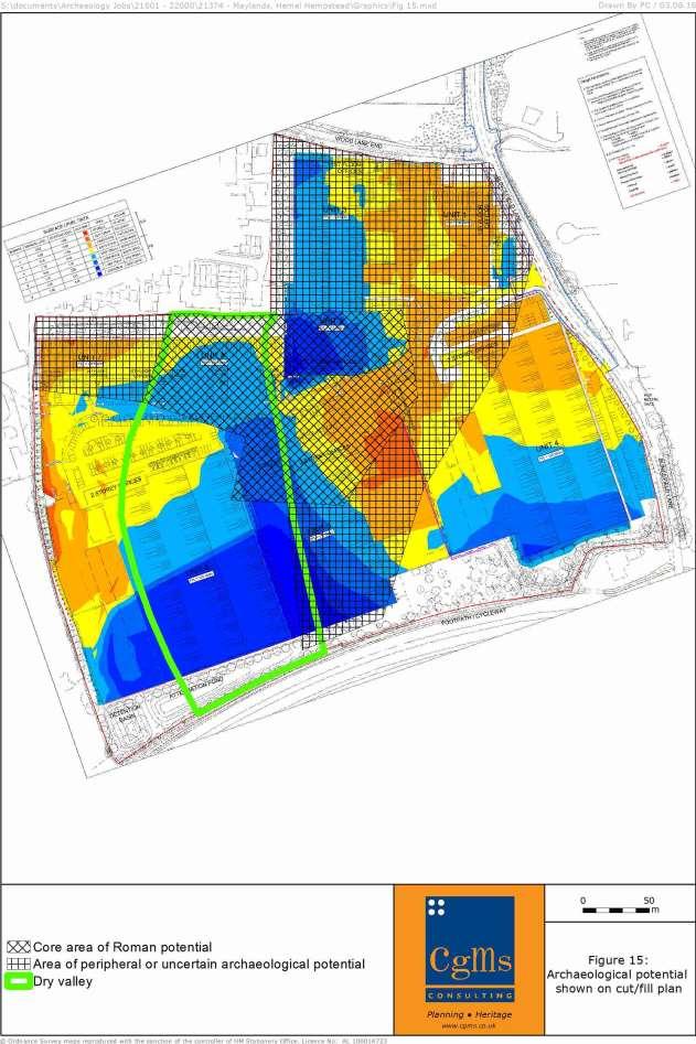
10 4.0 ARCHAEOLOGICAL AND HISTORICAL BACKGROUND, INCLUDING ASSESSMENT OF SIGNIFICANCE 4.1 Timescales used in this report are as follows. Prehistoric Palaeolithic 450,000 BC - 10,001 BC Mesolithic 10,000 BC - 4,001 BC Neolithic 4,000 BC - 1,801 BC Bronze Age 1,800 BC BC Iron Age 600 BC - AD 42 Historic Roman AD AD Saxon/Early Medieval AD AD Medieval AD AD Post Medieval AD AD Modern AD Present 4.2 Introduction This chapter reviews existing archaeological evidence for the site and the archaeological/historical background of the general area based on a consideration of evidence in the National Heritage List for England, Hertfordshire Historic Environment Record (HER) and various on-line sources for the study site and a surrounding 1km search area. It also considers the results of fieldwork undertaken in support of the current application A gazetteer of designated heritage assets, archaeological monuments and archaeological investigations and events is provided at Appendix 1. This chapter also considers the potential for as yet undiscovered archaeological assets on the site, in accordance with the NPPF. Chapter 5 subsequently considers site conditions and whether any theoretical potential identified in this chapter is likely to survive. 4.3 Designated Heritage Assets Data obtained from Historic England and the Local Planning Authority confirms that there are no designated heritage assets (Listed Buildings, Scheduled Monuments, Conservation Areas, Registered Battlefields or Parks and Gardens) on the study site (Figure 2). CgMs Ltd 8 PGC/SM/21374/02
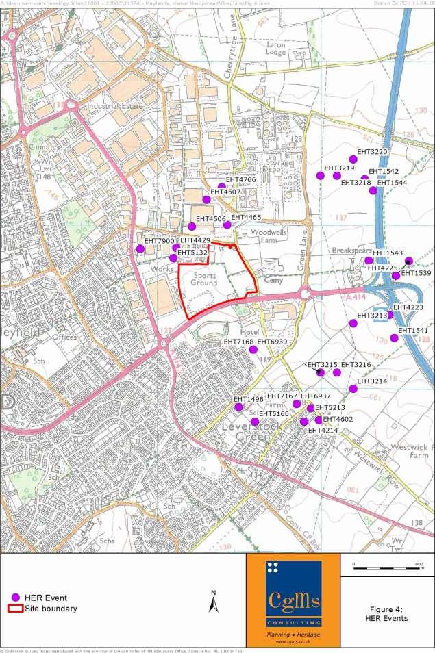
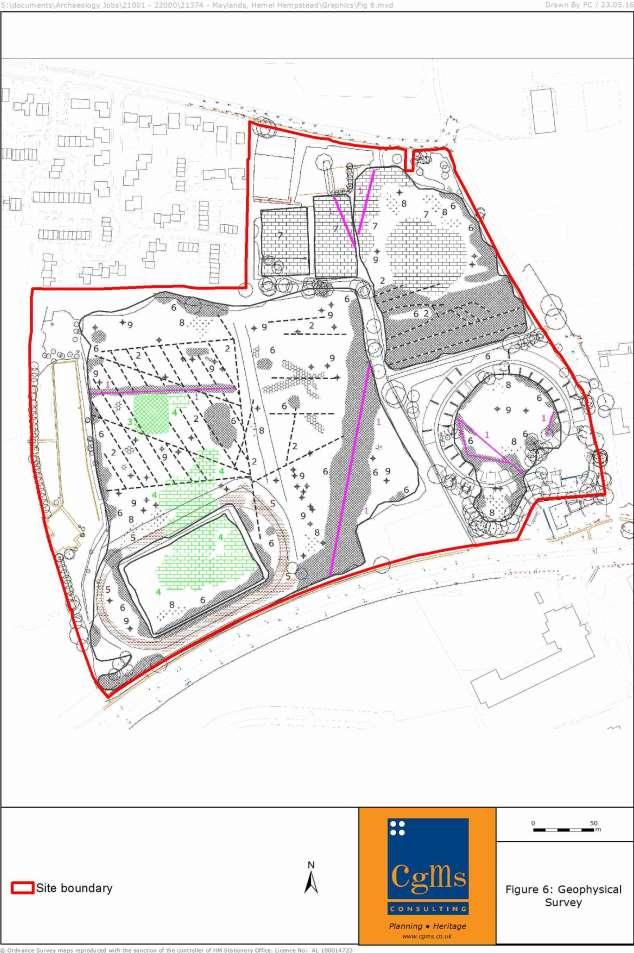
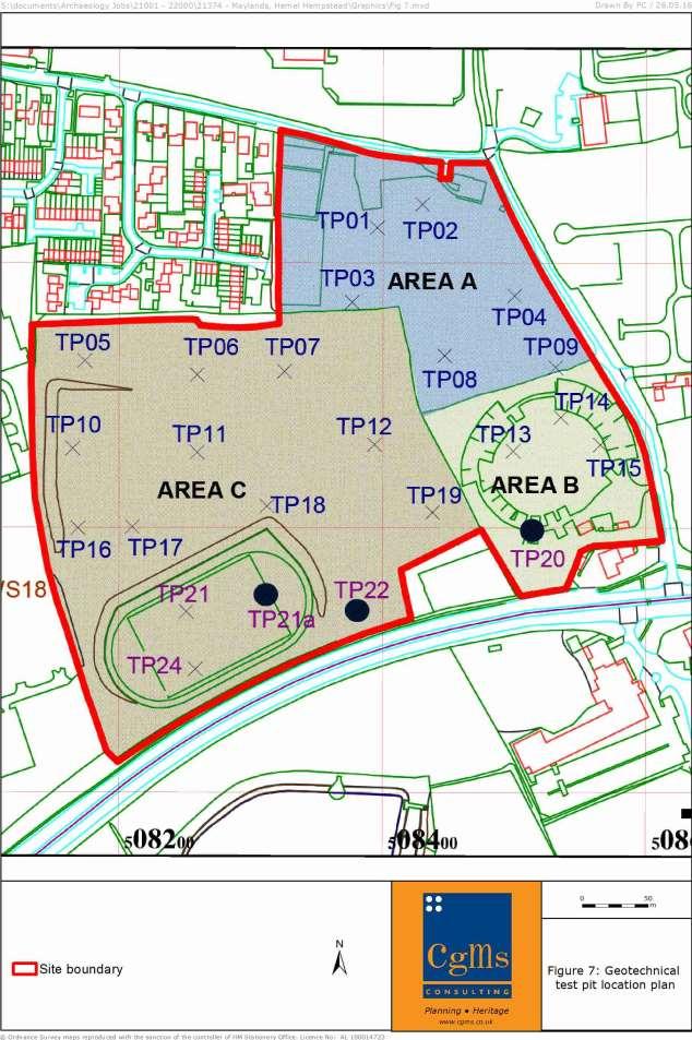
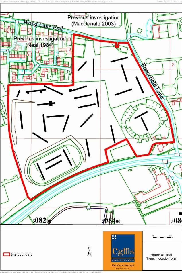
11 4.3.2 The closest Scheduled Monument to the study site is the Romano-Celtic temple complex at Wood Lane End (List Entry number ), 60m west of the study site at its closest point. There are no further Scheduled Monuments within the search area A separate report has been prepared giving consideration to built heritage assets (CgMs 2016). This report concludes that there are no impacts on the setting of any designated built heritage assets outside of the site A gazetteer of designated heritage assets within the search area is included at Appendix Non-Designated Heritage Assets and other archaeological monuments The data provided by the HER contains no Monument records within the study site, although the northern half of the site is located within an Archaeological Alert Area (DAC_38) relating to the Romano-Celtic temple complex at Wood Lane End. There are 60 Monuments within the search area (Figure 3). A gazetteer of HER records is included in Appendix Fieldwork undertaken in support of the current application has afforded a better understanding of the archaeology present, allowing the refinement of the previous theoretical Archaeological Alert Area, into core and peripheral areas of activity (Figure 15). 4.5 Previous Archaeological Investigations A geophysical survey (Stratascan 2016; Figure 6) has been undertaken across the study site, which identified no anomalies of archaeological origin, with all the anomalies identified of a modern or natural origin. These included features related to the sports fields and former running tracks, land drains, buried services, made ground, magnetic disturbance and scattered magnetic debris Archaeological monitoring (Albion Archaeology 2016a; Figure 7) was maintained during the excavation of 24 geotechnical testpits within the study site. This identified a single possible undated archaeological feature towards the centre of the site. In the eastern part of the study site limited landscaping was identified, comprising a small area of potential terrace build up. In contrast, the south-western part of the site appeared to have been heavily landscaped A subsequent trial trench evaluation (Albion Archaeology 2016b; Figure 8) was undertaken, comprising 28 trenches. This identified archaeological features within 17 trenches, comprising a late Neolithic/early Bronze Age pit, an Iron Age ditch, Roman CgMs Ltd 9 PGC/SM/21374/02
12 ditches/gullies, pits, postholes and a drying oven, and post-medieval quarry pits. Despite the proximity to the Scheduled Romano-Celtic temple complex, the Roman evidence from the trial trenches appeared to be domestic or agricultural in nature, not religious The nature and distribution of Roman features led to the identification of core and peripheral areas. The core area contained the drying oven, ditches/gullies, pits, and postholes. The peripheral areas identified contained significantly fewer features mainly ditches and produced smaller quantities of finds. It is likely that the core area represents domestic and agricultural activity and the peripheral areas adjacent fields The trenches also identified evidence for a palaeochannel, with twelve trenches containing modern made ground up to 1.8m thick, which appeared to have been dumped into a dry valley, caused by the palaeochannel, to level the ground prior to the construction of the sports ground. The survival of buried topsoil and subsoil suggests that in most places the made ground was deposited directly onto the existing ground surface. Due to considerable modern earthmoving within the study site, in some areas truncated archaeological features survive buried at a substantial depth, whilst elsewhere well-preserved features occur immediately beneath the modern subsoil. 4.6 Prehistoric The evaluation trenching of the study site (Albion Archaeology 2016b) identified a single sub-circular Prehistoric pit, measuring 0.65m in diameter and 0.33m deep. It contained thirteen pieces of worked flint broadly dating to the late Neolithic/early Bronze Age. An Iron Age ditch, measuring 1.4m wide and 0.74m deep was also identified, alongside further probable residual Iron Age pottery The HER records finds of Palaeolithic finds from Ellingham s Pit, 650m west-north-west of the site, including flint axes (540, 1303) and other flint artefacts (2276 & 7315) Four Neolithic/Bronze Age pits (16448) were excavated ahead of M1 widening works, 980m north-east of the site. Late Bronze Age to Early Iron Age pits, postholes and a ditch (16356; 16447) were also identified ahead of the works, as was a substantial assemblage of Prehistoric lithics (9642) Excavation 85m north of the site identified transitional late Bronze Age to early Iron Age activity (9203), including pits, ditches and post holes, with a further probable Prehistoric ditch (11824) recorded 50m north-west of the site. CgMs Ltd 10 PGC/SM/21374/02
13 4.6.5 The HER records further Prehistoric findspots, including Mesolithic and Neolithic flint tools (10812), a Neolithic flint arrowhead (585) and a Bronze Age knife (584) within the search area When the site is stripped it is likely that there will be a limited number of Neolithic/Bronze Age pits and it would not be surprising to find greater evidence of a Late Iron Age precursor to the Roman enclosures. 4.7 Roman The trial trenching undertaken across the site (Albion Archaeology 2016b) identified that the main focus of Roman activity, comprising a drying oven, ditches/gullies, pits, and postholes was located centrally within the study site. The pottery recovered suggested the majority of the features were 1st 2nd century in date. The drying oven, of the common T-shaped form, was constructed from up to four courses of broken tegulae, with a small number of bricks. Large amounts of grains and glume bases were recovered from the oven, representing accidentally burnt debris from the parching or drying of hulled wheat spikelets A large Romano-British pit was notable for the finds recovered from it, comprising a large quantity of ceramic building material and flint nodules. Rather than being a structural feature, it is likely that this material represents demolition debris derived from buildings within the adjacent temple complex. Some of the ditches excavated were on similar alignments to the boundaries identified within the temple complex, and most of these features probably defined fields/enclosures, although a pair of parallel features may relate to a trackway A Scheduled Romano-Celtic temple complex at Wood Lane End (List Entry number ; 94), thought to have been constructed during the early part of the second century AD, is located 60m west of the site. This comprises an extensive rectilinear temenos (sacred precinct), measuring some 85m north-west/south-east and 75m north east-south west, enclosed by a boundary wall. Within the temenos a subrectangular temple was identified, which may have stood to a height of at least 15m. A second building attached to the outer face of the north western wall has been interpreted as a schola (place of learning). Remains of a rectangular ancillary building were discovered to the south west of the schola, outside the temenos. The complex was extended during the mid-second century AD by the addition of a small bath suite just within the entrance to the temenos and a small square shrine or mausoleum was erected some 10m south-east of the temple. The complex appears to have fallen into disuse at the end of the second century AD, and may have been demolished to provide building materials for the fortification of Verulamium (St Albans) which was CgMs Ltd 11 PGC/SM/21374/02
14 constructed at this time. After demolition the area was given over to agriculture and post holes discovered during the investigations suggest that animal stockades were constructed over the site of the complex, remaining in use into the fourth century Despite the proximity to the temple complex, the nature of the evidence identified by the evaluation within the study site appears to have been domestic and agricultural in nature, rather than religious Roman pits and postholes (6824) were identified 100m north of the site by evaluation trenching, with ditches (9204) forming part of a probable field system identified by excavation, 140m north-west of the site Work to the west side of the M1 in advance of widening uncovered late Iron Age- Roman features including a trackway, lime kilns, a corn-drying oven, a field system, and part of a double-ditched curvilinear enclosure, with pits and postholes relating to possible structures in the enclosed area (10908). A possible Roman building (6823) is recorded on the HER, 800m east of the site Further evidence for Roman buildings (9622), was recorded by excavation at Leverstock Green, 890m south-east of the site. The possible route of a Roman road (4568) has been identified, 550m south-west of the site at its closest point The site contains evidence of Roman activity and shares alignments with the nearby Scheduled temple complex, which it appears broadly contemporary with. However, the evidence from the study site appears to represent domestic and agricultural activity, rather than an extension of the religious complex. 4.8 Saxon and Medieval No evidence dating to these periods was identified by the geophysical survey (Stratascan 2016), the monitoring of test pits (Albion Archaeology 2016a) or the trial trenching (Albion Archaeology 2016b) undertaken on the study site The district of Hamele (Hemel Hempstead) was given to the Bishop of London in 705 AD by Offa, King of Essex. It is recorded in the 1086 Domesday Survey as being a settlement located in the Hundred of Danish (Hertfordshire), with a total population of 23 a relatively large settlement Evidence of ridge and furrow cultivation (9205) was revealed by the excavation to the north of Wood End Lane, 100m north of the site, illustrating that this area found use as agricultural land during the Medieval period. Ahead of widening works for the M1, a CgMs Ltd 12 PGC/SM/21374/02
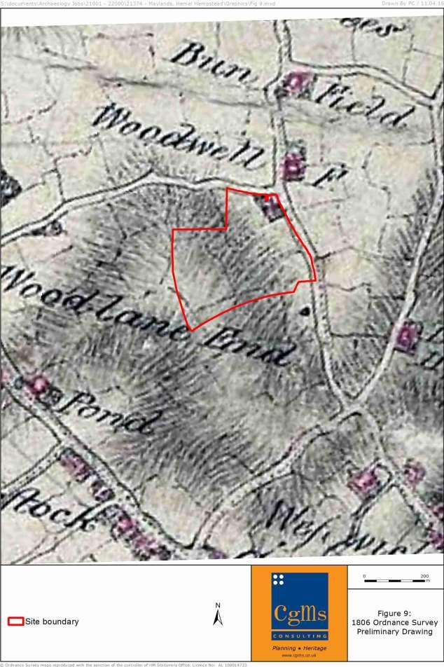
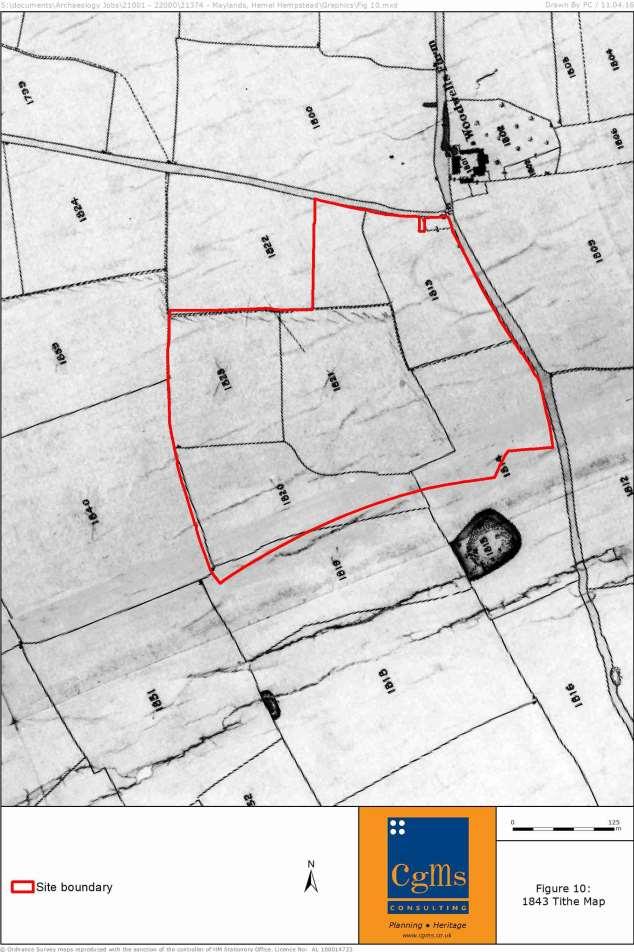
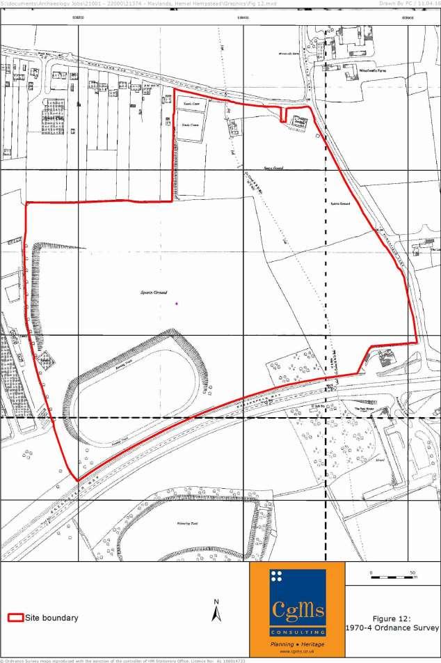
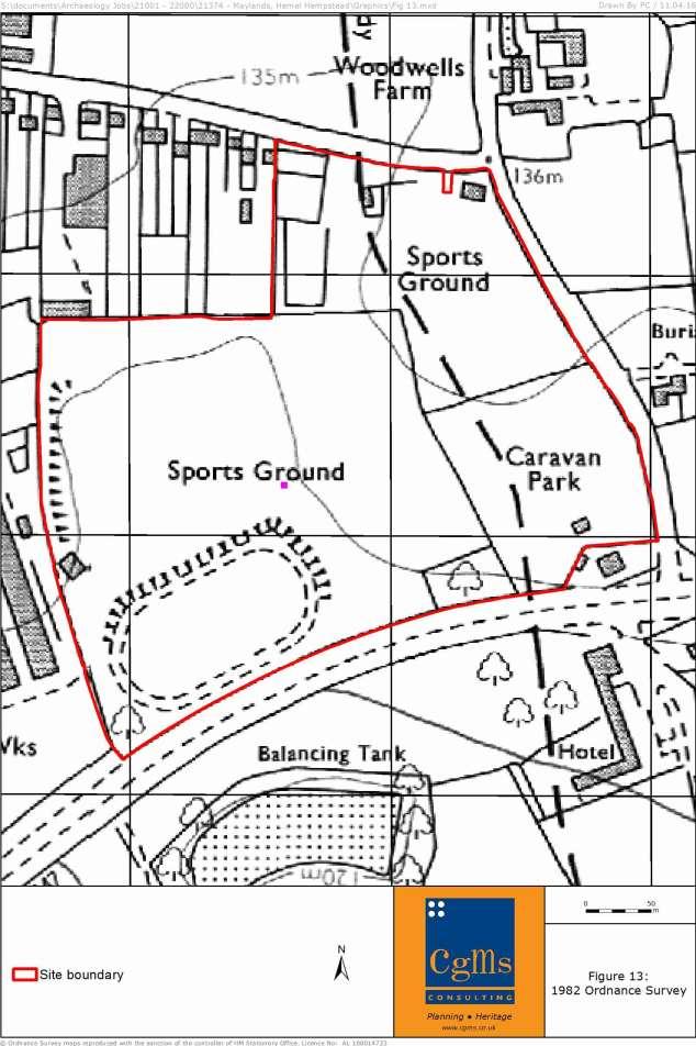
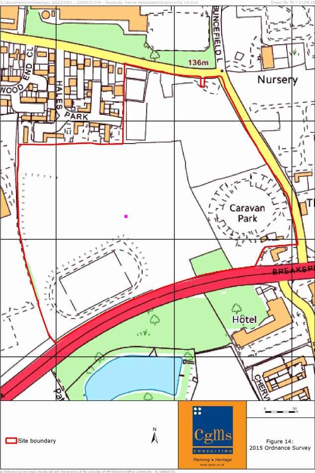
15 Medieval lime kiln, structure, oven and boundary ditches (9643), Medieval pits and postholes (16357; 16470), and possible Medieval trackway (16358) were excavated The evaluation of the study site did not identify any evidence dating to these periods, and the site appears to have been located outside areas of settlement. It is, therefore, considered to have a low potential for significant remains dating to the Saxon and Medieval period. 4.9 Post-Medieval and Modern The Post-Medieval/Modern records in the HER within the search area relate to buildings/monuments of a well-defined extent and nature that generally add little to the understanding of the study site s archaeological potential, and are therefore not discussed in any further detail The 1806 Ordnance Survey Preliminary drawing (Figure 9) shows the study site formed from a number of small fields. A small building is shown located in the northeastern corner of the site. Buncefield Lane to the east and Wood Lane End to the north are shown extant The 1843 Hemel Hempstead Tithe map (Figure 10) shows the site further subdivided, with the building in the north-eastern corner now demolished The 1879 Ordnance Survey (Figure 11) shows some consolidation of the fields, with the study site now formed predominantly from three fields, with a small area of plantation shown in the middle of the southern boundary The 1964 Ordnance Survey (not illustrated) shows the construction of Breakspear Way, forming the study site s southern boundary The Ordnance Survey (Figure 12) shows the construction of the terraced running track in the south-west corner of the study site. Further earthworks are shown against the western site boundary, adjacent to a sports pavilion. Another pavilion is shown in the north-eastern corner of the site, with more buildings and tennis courts shown further west The 1982 Ordnance Survey (Figure 13) labels the south-eastern part of the site as a Caravan Park, with a single building shown in this area The 2015 Ordnance Survey (Figure 14) shows further detail within the caravan park, of a circular hardstanding arrangement, and the demolition of the sports pavilions. CgMs Ltd 13 PGC/SM/21374/02
16 4.9.9 During these periods the study site was initially under agricultural use, before being used for sports grounds and a caravan park. It has a low potential for significant remains dating to the Post-Medieval and Modern periods. CgMs Ltd 14 PGC/SM/21374/02
17 4.10 Assessment of Significance Paragraph 128 of the NPPF states that planning decisions should be based on the significance of the heritage asset, and that the level of detail supplied by an applicant should be proportionate to the importance of the asset and should be no more than sufficient to review the potential impact of the proposal on the significance of that asset The assessment has established that there are no designated heritage assets on the proposed development site The Scheduled Romano-Celtic temple complex at Wood Lane End (List Entry number ; 94), comprising buried remains, is located 60m west of the site. The complex was originally identified in 1966 during the laying of a sewer pipe and was more fully investigated in advance of building work in for the residential properties that currently surround the temple complex. The remains of the temple complex only survive within the rear gardens of these properties, which front Hales Park. It is significant for its evidential value and setting does not form part of its significance Romano-Celtic temples were built and used throughout the Roman period from the mid first century AD to the late fourth/early fifth century AD. They were widespread throughout southern and eastern England, and they are rare nationally with only about 150 sites recorded in England. In view of their rarity and their importance in contributing to the picture of Roman religious practice, all Romano-Celtic temples with surviving archaeological potential are considered to be of national importance. The significance of the temple complex is vested in its evidential value and its potential to contribute to our understanding of this rare monument type. Its current setting is limited to its immediate environs, comprising the rear gardens of modern domestic dwellings, and it does not contribute to its significance. Development within the study site will not, therefore, impact upon the significance of this monument The trial trenching of the study site (Albion Archaeology 2016b) identified Roman remains that appeared to represent domestic and agricultural activity, comprising a drying oven, ditches/gullies, pits, and postholes. This Roman settlement appears to have been broadly contemporary with the temple complex, although given the possibility that the drying oven reuses building material from the complex, it appears some components date to after the temple complex (or part of it) had been dismantled. CgMs Ltd 15 PGC/SM/21374/02
18 The Roman remains present within the study site are significant for their evidential value. The study site forms part of the wider Roman landscape, surrounding the temple complex, and excavation of this Roman evidence will allow a deeper understanding of the historical development of this landscape, and contribution to local and regional research agendas. It will help to understand the landscape context of the Scheduled temple site, but the remains preserved within the study site are of a very different character to the temple complex. This and the effects of modern development truncating many of the features means that the archaeology on the site is of local to regional importance, significant for its evidential value and the potential to enhance our understanding of the wider landscape surrounding the Scheduled Monument It is likely that mitigation on the site will also identify a limited number of Neolithic/Bronze Age pits and it would not be surprising to find greater evidence of a Late Iron Age precursor to the Roman enclosures such evidence would be significant for its evidential value. CgMs Ltd 16 PGC/SM/21374/02
19 5.0 SITE CONDITIONS, THE PROPOSED DEVELOPMENT & IMPACT ON HERITAGE ASSETS 5.1 Site Conditions A site visit for this report was undertaken on 14th January 2016 (Plates 1-8), and subsequent monitoring meetings during the monitoring of the geotechnical test pits and the trial trenching were held on 24th March and 5th April respectively. The site is formed from two large fields, a disused caravan park and a small plantation of trees against the southern boundary Hardstanding and planting relating to the former caravan park (Plate 8) survive in the south-eastern corner of the site. The foundations of a former sports pavilion (Plate 6) survive against the western boundary, adjacent to an area of hardstanding for a car park. There were 2 tennis courts and stable buildings in the north western corner of the northern field The two large fields were under short grass so conditions were good for the identification of earthwork features; fairly widespread remodelling of the ground surface in the south-western part of the site for its previous use as a sports field was apparent. The intrusive investigations confirmed that significant earthmoving has been undertaken within the site. 5.2 The Proposed Development The study site is being proposed for the construction of new storage and distribution units, each with ancillary office space, to deliver approximately 55,000m 2 of new commercial floorspace (Use Class B8). 5.3 Impact on Heritage Assets There are no designated heritage assets on the proposed development site and there will be no impact upon any designated heritage assets or their settings within the wider area Trial trenching has identified a probable core area of Roman remains towards the centre of the site, flanked by areas of lower potential Areas of archaeological remains within the study site will be impacted upon by development, and require mitigation prior to construction. Until construction details, including foundations are available, it will not be possible to define the exact areas for mitigation. It is likely that in some of the areas of fill that preservation in situ of the archaeological remains will be possible in particular in the area of the former dry CgMs Ltd 17 PGC/SM/21374/02
20 valley (Figure 15), where up to 1.5m of made ground seals any archaeological horizons. CgMs Ltd 18 PGC/SM/21374/02
21 6.0 CONCLUSIONS 6.1 This archaeological desk-based assessment draws together the available archaeological, historic, topographic and land-use information in order to clarify the significance and archaeological potential of land proposed for development at. 6.2 It addresses the information requirements set out in the National Planning Policy Framework (NPPF) and Policy CS27 of the Dacorum Borough Council s Core Strategy, and provides the proportionate response sought by the NPPF. 6.3 There are no designated heritage assets or non-designated heritage assets on the proposed development site and there will be no impact upon any designated heritage assets or their settings within the wider area. The northern part of the site is located within an Area of Archaeological Significance associated with a Scheduled Ancient Monument located to the north of the site within the Hales Park area. 6.4 Following early pre-application discussions with Alison Tinniswood, Historic Environment Advisor at Hertfordshire County Council, an iterative programme of archaeological work has been undertaken within the site, with Written Schemes of Investigation for each element agreed with the LPA, comprising cart-based detailed geophysical survey; archaeological observation and recording of geotechnical trial pits and trial trenching. This has confirmed that whilst the site has been extensively terraced in the recent past there are zones that retain archaeological features. These are focused within the centre and north-western extents of the site, where there is evidence for Roman activity, including a corn drier and associated pits and ditches. A single Iron Age ditch was also identified. 6.5 It has been agreed with the Historic Environment Advisor that the heritage interest in the site can be safe-guarded by an appropriately worded archaeological condition. This will secure the implementation of a programme of archaeological excavation, recording and subsequent off-site assessment, analysis and reporting of any significant deposits that cannot be preserved in situ. Trenching has not yet been possible in the area of the stables or former tennis court and there will be a requirement for further evaluative work (and potentially mitigation) in these areas. 6.6 The conditioned works will mitigate the effects of development and the archaeological interest in the site will be preserved by record. CgMs Ltd 19 PGC/SM/21374/02
22 SOURCES CONSULTED General National Heritage List for England ( Heritage Gateway ( Hertfordshire Historic Environment Record (HER) Hertfordshire Archives and Local Studies Dacorum Borough Council ( Bibliographic ALBION ARCHAEOLOGY, 2016a. : Archaeological Observation and Recording of Geotechnical Test Pitting, report 2016/43 ALBION ARCHAEOLOGY, 2016b. : Archaeological Trial Trench Evaluation, report 2016/92 CGMS, Built Heritage Statement in respect of Maylands Gateway, Hemel Hempstead, Hertfordshire, report JCG21458 DCMS, Scheduled Monuments. Identifying, protecting, conserving and investigating nationally important archaeological sites under the Ancient Monuments and Archaeological Areas Act March 2010 ENGLISH HERITAGE, Conservation Principles: Policies and Guidance for the Sustainable Management of the Historic Environment HISTORIC ENGLAND, Historic Environment Good Practice Advice in Planning: Note 3 The Setting of Heritage Assets SOIL SURVEY, Soil survey of England and Wales, Soil Map 1:250,000 Sheet 4 STRATASCAN, Maylands Gateway, Hemel Hempstead, report J9444 Cartographic 1843 Hemel Hempstead Tithe map Ordnance Survey 1:2, , 1898, 1924, , , 1993, 1996 Ordnance Survey 1:10,560/1:10, , 1899, , 1938, 1947, 1960, 1964, 1982, 1992, 1996, 2006, 2015 CgMs Ltd 20 PGC/SM/21374/02
23 CgMs Ltd 21 PGC/SM/21374/02
24 CgMs Ltd 22 PGC/SM/21374/02
25 CgMs Ltd 23 PGC/SM/21374/02
26 CgMs Ltd 24 PGC/SM/21374/02
27 CgMs Ltd 25 PGC/SM/21374/02
28 CgMs Ltd 26 PGC/SM/21374/02
29 CgMs Ltd 27 PGC/SM/21374/02
30 CgMs Ltd 28 PGC/SM/21374/02
31 CgMs Ltd 29 PGC/SM/21374/02
32 CgMs Ltd 30 PGC/SM/21374/02
33 CgMs Ltd 31 PGC/SM/21374/02
34 CgMs Ltd 32 PGC/SM/21374/02
35 CgMs Ltd 33 PGC/SM/21374/02
36 CgMs Ltd 34 PGC/SM/21374/02
37 CgMs Ltd 35 PGC/SM/21374/02


38 Plate 1. View west across north-eastern part of site Plate 2. View north-west across north-eastern part of site CgMs Ltd 36 PGC/SM/21374/02


39 Plate 3. View south-west across western part of site Plate 4. View west along northern site boundary CgMs Ltd 37 PGC/SM/21374/02


40 Plate 5. View south along terrace in western part of site Plate 6. View south across former building in western part of site CgMs Ltd 38 PGC/SM/21374/02


41 Plate 7. View north-east across former running track Plate 8. View south-east across former caravan park CgMs Ltd 39 PGC/SM/21374/02
42 APPENDIX 1: GAZETTEER OF DESIGNATED HERITAGE ASSETS AND HER DATA HER Name & Location Date Number Description Monuments 94 ROMANO-CELTIC TEMPLE/MAUSOLEUM, WOOD LANE END, TL Roman HEMEL HEMPSTEAD Roman building remains found during the laying of a sewer pipe in 1966 were partly investigated 540 TWO PALAEOLITHIC FLINT AXES, ELLINGHAM'S PIT, TL Palaeolithic LEVERSTOCK GREEN 584 BRONZE AGE KNIFE, HEMEL HEMPSTEAD TL Bronze Age 585 FLINT ARROWHEAD, HEMEL HEMPSTEAD TL Neolithic 1303 PALAEOLITHIC TOOLS, ELLINGHAM'S PIT, LEVERSTOCK TL Palaeolithic GREEN, HEMEL HEMPSTEAD Ovate flint handaxes 2276 PALAEOLITHIC FLINT, ELLINGHAM'S PIT, LEVERSTOCK TL Palaeolithic GREEN 4568 PART OF SUPPOSED LINE OF ROMAN ROAD, 'ELSTREE TO TL Roman EATON BRAY', THROUGH HEMEL HEMPSTEAD Part of Viatores' route 169, through Leverstock Green and Hemel Hempstead 6823 POSSIBLE ROMAN BUILDING, BREAKSPEARS FARM, ST TL Roman MICHAELS 'Roman pottery and the 'rectangular plan' of a building were observed during the construction of the M1 at Breakspears Farm' 6824 ROMAN FEATURES, WOOD LANE END, HEMEL HEMPSTEAD Pits and post holes dating to the Roman period, found behind the warehouses TL Roman 7121 SITE OF POST-MEDIEVAL BRICK KILN, HIGH STREET GREEN, HEMEL HEMPSTEAD Site of a brick kiln, identified from the 1843 tithe map. The site is now occupied by houses 7122 SITE OF POST-MEDIEVAL KILN, SOUTH OF MAYLAND'S WOOD, HEMEL HEMPSTEAD Probable brick kiln 7126 SITE OF HIGHFIELD BRICKWORKS, MAYLAND WOOD, HEMEL HEMPSTEAD Extensive 19th century brickworks 7315 FLINT IMPLEMENTS, HIGHFIELD BRICKYARD, HEMEL HEMPSTEAD 'At the Highfield brickyard, northward of Wood Lane End, flint implements have been found by Sir John Evans' 9038 CROPMARKS OF CIRCULAR ENCLOSURE, WESTWICK ROW FARM, ST MICHAELS 9042 CROPMARKS OF LINEAR DITCHES, WESTWICK ROW FARM, ST MICHAELS 9043 CROPMARKS OF LINEAR FEATURES, ST MICHAELS Parallel linear marks which may be archaeological, or pipelines 9203 LATE BRONZE AGE/EARLY IRON AGE FEATURES, N OF WOOD LANE END, HEMEL HEMPSTEAD Pits, postholes and pottery 9204 ROMAN DITCHES, NORTH OF WOOD LANE END, HEMEL HEMPSTEAD Probably a field system 9205 RIDGE AND FURROW, N OF WOOD LANE END, HEMEL HEMPSTEAD 9622 ROMAN BUILDINGS, HANDPOST LODGE, LEVERSTOCK GREEN A ditch containing Roman building materials, and traces of a structure 9642 PREHISTORIC FLINT ASSEMBLAGE, M1 JUNCTION 8, ST MICHAELS High densities of chipped flint tools found in MEDIEVAL LIME KILN AND OTHER FEATURES, M1 JUNCTION 8, ST MICHAELS RURAL 12th-13th century post-built structure, ditches and lime kiln 9739 SITE OF LAWRENCE'S OR BOTTOM HOUSE FARM, GREEN LANE, LEVERSTOCK GREEN Post-medieval farmstead demolished in the mid 19th century TL TL TL TL TL TL TL TL TL TL TL TL TL TL Post Medieval Post Medieval Post Medieval Palaeolithic Unknown Unknown Unknown Modern Roman Later Bronze Age to Earlier Iron Age Roman Medieval to Post Medieval Roman Prehistoric Medieval Post Medieval CgMs Ltd 40 PGC/SM/21374/02
43 10535 SITE OF POST-MEDIEVAL FARMHOUSE, WESTWICK FARM, WESTWICK ROW 'Tudor' farmhouse demolished in the mid 19th century WESTWICK FARM, WESTWICK ROW Post-medieval farmstead with 17th century barns, altered in the mid 19th century HOLLOW WAY, SOUTH OF WESTWICK FARM, WESTWICK ROW Traces of a hollow way, the old course of Pancake Lane FLINT IMPLEMENTS, 8 BURLEIGH ROAD, LEVERSTOCK GREEN Tools and waste, apparently in situ FEATURES, S OF M1 JUNCTION 8, ST MICHAELS 1st and 2nd century features on the north side of a stream LONG CROSS SILVER PENNY, 87 LEVERSTOCK GREEN ROAD, LEVERSTOCK GREEN SITE OF BRICKFIELD AND KILN, TILEKILN LANE, BENNETTS END, HEMEL HEMPSTEAD PROBABLE PREHISTORIC DITCH, NEAR WOOD END CLOSE, HEMEL HEMPSTEAD Ditch containing flints and a single sherd LATE IRON AGE PIT, HANDPOST LODGE, LEVERSTOCK GREEN Pit containing pottery and fired clay SITE OF HANDPOST LODGE, LEVERSTOCK GREEN 1930s house on the site of an older building SITE OF POST-MEDIEVAL HOUSE, HANDPOST LODGE, LEVERSTOCK GREEN 18th century or earlier house, replaced in the 1930s PARCHMARKS AND POST-MEDIEVAL FINDS, LEVERSTOCK GREEN PRIMARY SCHOOL, LEVERSTOCK GREEN Post-medieval pit and marks of possible clay pits LATE BRONZE AGE/EARLY IRON AGE FEATURES, BUNCEFIELD DEPOT, HEMEL HEMPSTEAD Ditch and pits scattered over an area west of the motorway MEDIEVAL FEATURES, NW OF M1 JUNCTION 8, HEMEL HEMPSTEAD Group of pits or postholes which may represent a building ROMAN OR MEDIEVAL TRACKWAY, N OF M1 JUNCTION 8, HEMEL HEMPSTEAD Track or hollow way which is possibly medieval LATE BRONZE TO EARLY IRON AGE FEATURES, M1 JUNCTION 8, HEMEL HEMPSTEAD Structures, pits, and cremations NEOLITHIC-EARLY BRONZE AGE PITS, M1 JUNCTION 8, HEMEL HEMPSTEAD Four pits containing flint tools TL TL TL TL TL TL TL TL TL TL TL TL TL TL TL TL TL Post Medieval Post Medieval Post Medieval Lower Mesolithic to Late Neolithic Late Iron Age to Early Roman Medieval Post Medieval Prehistoric Late Iron Age Modern Post Medieval Post Medieval Later Bronze Age to Earlier Iron Age Medieval Early Roman to Medieval Later Bronze Age to Earlier Iron Age Early Neolithic to Earlier Bronze Age Roman ROMAN DITCHES AND PITS, M1 JUNCTION 8, HEMEL HEMPSTEAD TL DITCH AND MEDIEVAL PITS, BREAKSPEARS FARM, GREEN TL Undated LANE, HEMEL HEMPSTEAD Medieval Ten pits, two containing medieval pottery, and a ditch; possibly all the same date UNDATED PIT AND POST HOLE, BOUNDARY WAY, HEMEL TL Unknown HEMPSTEAD Two small undated features SITE OF BUNCEFIELD, BUNCEFIELD LANE, HEMEL HEMPSTEAD TL Post Medieval Post-medieval hamlet within 'Bunce Field' SITE OF THREE CHERRYTREES FARM, THREE CHERRY TREES TL Post Medieval LANE, HEMEL HEMPSTEAD One of two adjacent post-medieval farmsteads with this name SITE OF THREE CHERRYTREES FARM, THREE CHERRY TREES TL Post Medieval LANE, HEMEL HEMPSTEAD One of two adjacent post-medieval farmsteads with this name, this one demolished in the late 19th century SITE OF HIGHSTREET FARM, HIGH STREET GREEN, HEMEL TL Post Medieval HEMPSTEAD 19th century planned farmstead SITE OF COXPOND FARM, LEVERSTOCK GREEN ROAD, HEMEL TL Post Medieval HEMPSTEAD Post-medieval farmstead, demolished before LITTLE COXPOND FARMHOUSE, LEVERSTOCK GREEN ROAD, TL Post Medieval CgMs Ltd 41 PGC/SM/21374/02
44 HEMEL HEMPSTEAD 16th century timber-framed house, apparently once a small farmhouse SITE OF WOODWELL'S FARM, BUNCEFIELD LANE, HEMEL HEMPSTEAD Post-medieval farmstead with possible medieval origins SITE OF WOODLANE END FARM, LEVERSTOCK GREEN, HEMEL HEMPSTEAD Post-medieval farmstead in an area of orchards, gentrified in the earlier 20th century and demolished to make way for post-war housing SITE OF THE SARACEN'S HEAD, LEVERSTOCK GREEN, HEMEL HEMPSTEAD Post-medieval public house rebuilt in the mid 19th century and demolished in the mid 20th century DELL COTTAGE, WESTWICK ROW, HEMEL HEMPSTEAD Post-medieval house HOLY TRINITY CHURCH, BEDMOND ROAD, LEVERSTOCK GREEN 1840s Decorated Gothic church SITE OF BAPTIST CHAPEL, BEDMOND ROAD, LEVERSTOCK GREEN Listed Buildings Grade II* NORTHEND COTTAGE, BEDMOND ROAD, LEVERSTOCK GREEN, HEMEL HEMPSTEAD TL TL TL TL TL TL TL Post Medieval Post Medieval Post Medieval Post Medieval Post Medieval Post Medieval Post Medieval Grade II BREAKSPEARS FARM, GREEN LANE, LEVERSTOCK GREEN TL Post Medieval HILL FARM, LEVERSTOCK GREEN, HEMEL HEMPSTEAD TL Post Medieval LEVERSTOCK GREEN FARM, LEVERSTOCK GREEN, HEMEL HEMPSTEAD TL Post Medieval THE CRAB TREE, LEVERSTOCK GREEN, HEMEL HEMPSTEAD TL Post Medieval CgMs Ltd 42 PGC/SM/21374/02
Land adjacent to Dingle Dock, Front Street, East Garston
 Land adjacent to Dingle Dock, Front Street, East Garston An Archaeological Watching Brief for Dr J Davies by Jo Pine Thames Valley Archaeological Services Site Code DEG99/82 January 2000 Summary Site name:
Ivol Buildings, Woodcote Road, South Stoke, Oxfordshire
 Ivol Buildings, Woodcote Road, South Stoke, Oxfordshire An Archaeological Watching Brief For Christ Church, Oxford by Pamela Jenkins Thames Valley Archaeological Services Ltd Site Code IBSS 04/03 March
Chitty Farmhouse Extension, Wall Lane, Silchester, Hampshire
 Chitty Farmhouse Extension, Wall Lane, Silchester, Hampshire An Archaeological Watching Brief For In Touch by Andrew Mundin Thames Valley Archaeological Services Ltd Site Code CFS 08/52 May 2008 Summary
Garage Site, Foots Cray High Street, Sidcup, Kent, London Borough of Bexley
 Garage Site, Foots Cray High Street, Sidcup, Kent, London Borough of Bexley An Archaeological Evaluation for Mizen Design Build by Andy Taylor Thames Valley Archaeological Services Ltd FOC 07 September
ARCHAEOLOGICAL S E R V I C E S. Land north of Orchard Close, Hallow, Worcestershire. Archaeological Evaluation. by Kyle Beaverstock
 T H A M E S V A L L E Y ARCHAEOLOGICAL S E R V I C E S Land north of Orchard Close, Hallow, Worcestershire Archaeological Evaluation by Kyle Beaverstock Site Code: OCW15/224 (SO 8285 5848) Land north of
Meales Farm, Sulhamstead, West Berkshire
 Meales Farm, Sulhamstead, West Berkshire An Archaeological Watching Brief For Mr. Robert Astor by Steve Ford Thames Valley Archaeological Services Ltd Site Code CHH02/29 May 2002 Summary Site name: Meales
Archaeology and Planning in Greater London. A Charter for the Greater London Archaeology Advisory Service
 Archaeology and Planning in Greater London A Charter for the Greater London Archaeology Advisory Service THE PURPOSE OF THE CHARTER This Charter sets out how English Heritage will provide archaeological
Archaeological Investigation in advance of Development at 2 Palace Cottages, Charing Palace, Charing, Kent
 Archaeological Investigation in advance of Development at 2 Palace Cottages, Charing Palace, Charing, Kent Site Code CHAR-EV-14 NGR 95412 49439 Date of Report 18/12/2014 Swale and Thames Archaeological
Archaeological evaluation at Willowdene, Chelmsford Road, Felsted, Essex
 Archaeological evaluation at Willowdene, Chelmsford Road, Felsted, Essex August 2013 report prepared by Ben Holloway on behalf of Mr Anthony McGurren Planning reference: UTT/13/0235 CAT project ref.: 13/07g
ARCHAEOLOGICAL EVALUATION AT THE FORMER WATTON GARDEN CENTRE, NORWICH ROAD, WATTON, NORFOLK OCTOBER 2003 (Accession number WAT)
") NORTHAMPTONSHIRE ARCHAEOLOGY NORTHAMPTONSHIRE COUNTY COUNCIL NOVEMBER 2003 (Planning Application No: 3PL/1997/048/0 ARCHAEOLOGICAL EVALUATION AT THE FORMER WATTON GARDEN CENTRE, NORWICH ROAD, WATTON, NORFOLK
NORTHAMPTONSHIRE ARCHAEOLOGY NORTHAMPTONSHIRE COUNTY COUNCIL NOVEMBER 2003 (Planning Application No: 3PL/1997/048/0 ARCHAEOLOGICAL EVALUATION AT THE FORMER WATTON GARDEN CENTRE, NORWICH ROAD, WATTON, NORFOLK
Newcombe House & Kensington Church Street
 Newcombe House & Kensington Church Street Archaeological Evaluation September 2017 Summary Site name: Newcombe House, Kensington Church Street, Notting Hill, London Grid reference: TQ 25318 80372 Site
Archaeological Evaluation and Assessment of Land at Kent Cottage, 19 Chapel Street, Hythe, Kent
 Archaeological Evaluation and Assessment of Land at Kent Cottage, 19 Chapel Street, Hythe, Kent Planning Application Y13/0463/SH Date of Report: 29/04/2015 Report for Marc Carney SWAT. ARCHAEOLOGY Swale
Archaeological Evaluation and Assessment of Land at Minnis Beeches, Canterbury Road, Swingfield, Dover, Kent
 Archaeological Evaluation and Assessment of Land at Minnis Beeches, Canterbury Road, Swingfield, Dover, Kent NGR: TQ 6307 1545 Site Code: MB-EV-10 (Planning Consent Y10/0311/SH) Report for Thorndene Ltd.
Bridge House, Ham Island, Old Windsor, Berkshire
 Bridge House, Ham Island, Old Windsor, Berkshire An Archaeological Watching Brief for Mr A Chadwick by Alan Ford Thames Valley Archaeological Services Site Code BHHI98/55 August 1998 Bridge House, Ham
Archaeological trial-trenching evaluation: New Hall School, The Avenue, Boreham, Essex. July 2015
 Archaeological trial-trenching evaluation: New Hall School, The Avenue, Boreham, Essex report prepared by Ben Holloway on behalf of New Hall School Planning reference: 14/01846/FUL CAT project ref.: 15/04i
A Research Framework for the Archaeology of Wales Version 01, Final Paper Neolithic and Earlier Bronze Age
 NEOLITHIC AND EARLIER BRONZE AGE Introduction The introduction of farming around 4000 BC had a dramatic impact on the landscape of Wales and fundamentally changed they ways in which people lived and interacted.
An Archaeological Evaluation at Granta Cottages, Newmarket Road, Great Chesterford, Essex. August 2015
 An Archaeological Evaluation at Granta Cottages, Newmarket Road, Great Chesterford, Essex August 2015 by Pip Parmenter and Ben Holloway on behalf of Mr G Elmer and Mrs L King CAT project ref.: 15/06a NGR:
New horse training area, Manor Farm, Great Kimble, Buckinghamshire
 New horse training area, Manor Farm, Great Kimble, Buckinghamshire An Archaeological Watching Brief For Redwing Structures (Marlow) Limited by Andy Taylor Thames Valley Archaeological Services Ltd Site
Northbury Farm, Castle End Road, Ruscombe, Berkshire
 Northbury Farm, Castle End Road, Ruscombe, Berkshire An Archaeological Watching Brief For Sir Colin and Lady Southgate by Danielle Milbank Thames Valley Archaeological Services Ltd Site Code NFR 07/120
Land at Downsview Avenue, Storrington, West Sussex
 Land at Downsview Avenue, Storrington, West Sussex An Archaeological Evaluation for Bellwinch Homes Limited by Andy Taylor Thames Valley Archaeological Services Ltd Site Code DAS 04/21 March 2004 Summary
ARCHAEOLOGICAL S E R V I C E S. Hurley Manor, High Street, Hurley, Berkshire. Archaeological Evaluation. by James McNicoll-Norbury
 T H A M E S V A L L E Y ARCHAEOLOGICAL S E R V I C E S Hurley Manor, High Street, Hurley, Berkshire Archaeological Evaluation by James McNicoll-Norbury Site Code: HMH14/51 (SU 8252 8378) Hurley Manor,
Appletree, Thames Street, Sonning Berkshire
 Appletree, Thames Street, Sonning Berkshire An Archaeological Watching Brief for Mr and Mrs A Popham by Sian Anthony Thames Valley Archaeological Services Ltd Site Code ATS 02/83 October 2002 Summary Site
Epsom Water Works, East Street, Epsom, Surrey
 Epsom Water Works, East Street, Epsom, Surrey An Archaeological Desk-Based Assessment for St James Homes Ltd by Steve Ford Thames Valley Archaeological Services Site Code ESE99/85 December 1999 Epsom Water
Archaeological evaluation on land at Mersea Fleet Way, Chelmer Road, Braintree, Essex, CM7 3PZ
 Archaeological evaluation on land at Mersea Fleet Way, Chelmer Road, Braintree, Essex, CM7 3PZ by Laura Pooley figures by Ben Holloway and Emma Holloway fieldwork by Ben Holloway, Robin Mathieson, Nigel
Pinnocks Wood Equestrian Centre, Burchett s Green, Maidenhead, Berkshire
 Pinnocks Wood Equestrian Centre, Burchett s Green, Maidenhead, Berkshire An Archaeological Watching Brief For Mr David Eyles by Andrew Mundin Thames Valley Archaeological Services Ltd Site Code POB 08/69
National Character Area 70 Melbourne Parklands
 Summary The are a landscape of rolling farmland, parkland and woodland on the northern flanks of the ridge between Burton upon Trent and Swadlincote. The land slopes down to the River Trent, which borders
Elm Park, Station Road, Ardleigh, Essex, CO7 7RT: archaeological watching brief on installation of new water pipe
 Elm Park, Station Road, Ardleigh, Essex, CO7 7RT: archaeological watching brief on installation of new water pipe November 2015 report prepared by Howard Brooks BA FSA MCIfA on behalf of Partnerships in
ARCHAEOLOGICAL S E R V I C E S. Manor Farm, Launton, Bicester, Oxfordshire. Archaeological Watching Brief. by Aiji Castle. Site Code: LBO13/220
 T H A M E S V A L L E Y ARCHAEOLOGICAL S E R V I C E S Manor Farm, Launton, Bicester, Oxfordshire Archaeological Watching Brief by Aiji Castle Site Code: LBO13/220 (SP 6035 2285) Manor Farm, Launton, Bicester,
High Speed Rail (London- West Midlands)
") High Speed Rail (London- West Midlands) Draft Environmental Minimum Requirements Annex 3: Draft Heritage Memorandum November 2013 ESA 4.4 High Speed Rail (London- West Midlands) Draft Environmental Minimum
High Speed Rail (London- West Midlands) Draft Environmental Minimum Requirements Annex 3: Draft Heritage Memorandum November 2013 ESA 4.4 High Speed Rail (London- West Midlands) Draft Environmental Minimum
Land South-West of Mill Co age, Gidding Road, Sawtry, Cambridgeshire Evalua on Report
 Land South-West of Mill Coage, Gidding Road, Sawtry, Cambridgeshire Evaluaon Report August 2017 Client: CgMs Consulng Issue No: 1 OA East Report No: 2080 NGR: TL 1623 8329 Oxford Archaeology Ltd i 3 August
MONITORING REPORT: No. 283
 MONITORING REPORT: No. 283 Dunluce Castle Visitor Centre Option Site D Magheracross Co. Antrim AE/14/109E Dermot Redmond List of Contents Site Specific Information 1 Account of the Monitoring 2 Discussion
Archaeological monitoring at Clintons, Bury Green, Little Hadham, Hertfordshire April 2008
 Archaeological monitoring at Clintons, Bury Green, Little Hadham, Hertfordshire April 2008 report prepared by Ben Holloway on behalf of Charles Britton Equestrian Construction CAT project ref.: 08/3b NGR:
Glue Pot Farm, Edwards Lane, Bramfield, Suffolk. BMF 024
 Glue Pot Farm, Edwards Lane, Bramfield, Suffolk. BMF 024 Archaeological Evaluation Report SCCAS Report No. 2013/107 Client: Keith Frost Architectural Design Services Author: Linzi Everett August 2013 SCCAS
Interim Statement on Archaeological Evaluation on land immediately to the east of the Manor Lodge, Manor Lane, Sheffield, South Yorkshire
 Archaeological Research & Consultancy at the University of Sheffield Research School of Archaeology West Court 2 Mappin Street Sheffield S1 4DT Phone 0114 2225106 Fax 0114 2797158 Interim Statement 1107.2
New Media Building, Goldsmiths College, New Cross, London Borough of Lewisham
 New Media Building, Goldsmiths College, New Cross, London Borough of Lewisham An Archaeological Evaluation for Willmott Dixon Construction by Andy Taylor Thames Valley Archaeological Services Ltd Site
Historic England Advice Report 26 August 2016
 Case Name: Kingsland Castle Case Number: 1435892 Background Historic England has been asked to review the scheduling for Kingsland Castle. The land on which the monument lies is understood to be for sale.
9 Archaeology & Cultural Heritage
 High Clachaig Wind Farm Scoping Report Page 56 9 Archaeology & Cultural Heritage 9.1 Introduction Cultural heritage in this context means the above- and below-ground archaeological resources, built heritage,
Archaeological Monitoring of Land at 29 Royal Pier Road, Gravesend, Kent
 Archaeological Monitoring of Land at 29 Royal Pier Road, Gravesend, Kent Site Code ROY/WB/15 Report for Dr Maxted Date of report 06/10/2015 SWAT ARCHAEOLOGY Swale and Thames Archaeological Survey Company
Gryme s Dyke, Stanway Green
 Gryme s Dyke, Stanway Green A short assessment of the archaeological impact of contractor s groundworks at the southern end of the Gryme s Dyke Middle earthwork February 2000 Archive report on behalf of
Archaeological evaluation at Stables, Hatch Farm, Fen Lane, Bulphan, Essex, RM14 3RL
 Archaeological evaluation at Stables, Hatch Farm, Fen Lane, Bulphan, Essex, RM14 3RL November-December 2016 by Laura Pooley figures by Ben Holloway and Emma Holloway fieldwork by Ben Holloway and Alec
White Cliffs Business Park, Dover, Kent
 White Cliffs Business Park, Dover, Kent Archaeological Desk-Based Assessment Report Project Code: WCBP-DA-15 Planning Ref: Pre-application NGR: 631378 144379 Report No: 2016/4 Archive No: 3671 July 2016
Stanwick Neighbourhood Plan
 Stanwick Neighbourhood Plan Heritage Audit Stanwick Neighbourhood Plan Steering Group August 2015 Purpose of the Heritage Audit It is a core planning principle within National Planning Policy Framework
Centre for Archaeological Fieldwork Evaluation/Monitoring Report No Monitoring Report No. 201
 Monitoring Report No. 201 Land adjacent to 58 Drumreagh Road Drumreagh Ballygowan Co. Down LICENCE NO.: AE/10/91E BRIAN SLOAN 1 Site Specific Information Site Name: Land adjacent to 58 Drumreagh Road,
EVALUATION REPORT No. 300
 EVALUATION REPORT No. 300 Southwest of 2A Cloughey Road, Portaferry, Co. Down Licence No.: AE/135/85E Sapphire Mussen Report Date: 14 th May 2015 Site Specific Information Site Name: [Southwest of 2a]
Proposed Retirement Village Cole Green Way, Hertford. Archaeology Statement
 RETIREMENT LIVING MADE BETTER Proposed Retirement Village Cole Green Way, Hertford Archaeology Statement Woodlands Retirement Village RETIREMENT LIVING MADE BETTER Retirement Living Made Better Archaeology
13.0 ARCHAEOLOGY AND CULTURAL HERITAGE
 13.0 ARCHAEOLOGY AND CULTURAL HERITAGE Introduction 13.1 This chapter of the ES assesses the likely significant effects of the Overall Development in terms of archaeology and cultural heritage and is supported
Archaeological evaluation at Redbank, Bury Water Lane, Newport, Essex, CB11 3TZ
 Archaeological evaluation at Redbank, Bury Water Lane, Newport, Essex, CB11 3TZ March 2017 by Laura Pooley figures by Ben Holloway and Emma Holloway fieldwork by Ben Holloway with Harvey Furniss and Elliott
Merrowdene, Earleydene, Sunninghill, Berkshire
 Merrowdene, Earleydene, Sunninghill, Berkshire An Archaeological Watching Brief For Mr and Mrs Jackson by Andy Taylor Thames Valley Archaeological Services Ltd Site Code MES 05/88 January 2006 Summary
New Swimming Pool,West Meon House, West Meon, Hampshire
 New Swimming Pool,West Meon House, West Meon, Hampshire An Archaeological watching brief and building recording for Mr and Mrs Younger by Danielle Milbank Thames Valley Archaeological Services Ltd Site
Examination of South Cambridgeshire Local Plan
 Matter SC6A - Policy SS/5 Waterbeach New Town Historic England( formerly English Heritage) 874 Rep Nos 59748, 60250, 60253 Examination of South Cambridgeshire Local Plan Historic England, Hearing Statement
ARCHAEOLOGICAL S E R V I C E S. Becks, Park Lane, North Newington, Banbury, Oxfordshire. Archaeological Watching Brief.
 T H A M E S V A L L E Y ARCHAEOLOGICAL S E R V I C E S Becks, Park Lane, North Newington, Banbury, Oxfordshire Archaeological Watching Brief by Andy Mundin Site Code: BPN16/105 (SP 4207 3978) Becks, Park
Archaeological evaluation at New Hall School, The Avenue, Boreham, Chelmsford, Essex, CM3 3HS
 Archaeological evaluation at New Hall School, The Avenue, Boreham, Chelmsford, Essex, CM3 3HS December 2016 by Laura Pooley with contributions by Stephen Benfield figures by Ben Holloway and Emma Holloway
Evaluation/Monitoring Report No. 243
 60m NORTH OF 64 BALLYGROOBANY ROAD BALLYNAHINCH RICHHILL COUNTY ARMAGH LICENCE NO.: AE/12/91E NAOMI CARVER 1 Site Specific Information Site Name: site 60m north of 64 Ballygroobany Road, Ballynahinch,
Useful Studio 1st Floor, The Clove Building 4 Maguire Street, Butler s Wharf London SE1 2NQ
 Ms M Barlow Useful Studio 1st Floor, The Clove Building 4 Maguire Street, Butler s Wharf London SE1 2NQ Our ref: PL00049085 By email: michelle.b@usefulstudio.co.uk 12 th December 2016 Dear Ms Barlow, Re:
DACORUM GOLDEN PARSONAGE Great Gaddesden Brief Description Principal Building: Approach: Stable block other utilitarian buildings: Walled Garden:
 HERTFORDSHIRE GARDENS TRUST LOCAL LIST: DACORUM Present Name of Site GOLDEN PARSONAGE Historic Name (if known) Parish/Town Great Gaddesden National Grid Reference of Principal Building: TL051 125 Present
Archaeological evaluation: land to the rear of Clare Road, Braintree, Essex
 Archaeological evaluation: land to the rear of 41-45 Clare Road, Braintree, Essex March 2014 commissioned by Mr Mark Plummer report prepared by Ben Holloway and Howard Brooks Planning reference: 13/000585/FUL,
Old Town Hall, Market Place, Faringdon, Oxfordshire
 Old Town Hall, Market Place, Faringdon, Oxfordshire Building Recording and Archaeological Watching Brief for Great Faringdon War Memorial Trust by Jamie Preston and Steve Ford Thames Valley Archaeological
NAA SITE REF: HG2-22 CHURCH STREET, BOSTON SPA LEEDS LDF SITE ALLOCATIONS PLAN PRE-SUBMISSION CHANGES (FEBRUARY 2017) HERITAGE REPRESENTATIONS
 HERITAGE REPRESENTATIONS") NAA LEEDS LDF SITE ALLOCATIONS PLAN PRE-SUBMISSION CHANGES (FEBRUARY 2017) HERITAGE REPRESENTATIONS Northern Archaeological Associates Ltd. Marwood House Harmire Enterprise Park Barnard Castle Co. Durham
NAA LEEDS LDF SITE ALLOCATIONS PLAN PRE-SUBMISSION CHANGES (FEBRUARY 2017) HERITAGE REPRESENTATIONS Northern Archaeological Associates Ltd. Marwood House Harmire Enterprise Park Barnard Castle Co. Durham
Downton Manor, Downton, near Lymington, Hampshire
 Downton Manor, Downton, near Lymington, Hampshire An Archaeological Evaluation for New Milton Sand and Gravel by Sian Anthony Thames Valley Archaeological Services Ltd Site Code DMD03/20 May 2003 Summary
INTRODUCTION CURRENT APPLICATION
 05/01805/FUL & 05/01807/LBC ERECTION OF A SINGLE DWELLING HOUSE WITH ANCILLARY ACCOMMODATION AT Flamingo Zoological Gardens, Olney Road, Weston Underwood FOR Mr A J Crowther (as amended by letter dated
Designations protecting the historic designed landscape
 Historic Landscape Project Designations protecting the historic designed landscape A. Key national designations affecting the historic environment: 1. Listed buildings 2. Scheduled Monuments (generally
Forterra- Kimbolton Red Multi (sample ordered but awaited)
") Adeyfield church Discharge of pre- commencement planning conditions Planning reference: 4/00518/13/MFA To be read in conjunction with revised drawings: 1115 PL2-01D1 / 1115 PL2-02b / 1115 PL2-03B Pre-
Adeyfield church Discharge of pre- commencement planning conditions Planning reference: 4/00518/13/MFA To be read in conjunction with revised drawings: 1115 PL2-01D1 / 1115 PL2-02b / 1115 PL2-03B Pre-
PANSHANGER QUARRY, Hertfordshire
 PANSHANGER QUARRY, Hertfordshire Proposed enhanced restoration of Phases F & H Briefing Note 1 March 2015 INERT (INACTIVE) RESTORATION MATERIALS, CONTROLS AND OPERATIONS 1 Introduction This briefing note
Replacement Golf Course Facilities and Residential Development, Churston. Environmental Statement Non-Technical Summary
 Replacement Golf Course Facilities and Residential Development, Churston Environmental Statement Non-Technical Summary July 2011 Reproduced from the Ordnance Survey s map with the permission of the Controller
Greater London. Greater London 6/42 (D.01.M001) TQ
 TQ") Authority 6/42 (D.01.M001) TQ 54207390 ST. JAME'S INVESTMENTS, LOWFIELD STREET AND MARKET STREET, DARTFORD Environmental Statement. Archaeology. Volume 9 of 10 AOC Archaeology Group Twickenham : AOC Archaeology
Authority 6/42 (D.01.M001) TQ 54207390 ST. JAME'S INVESTMENTS, LOWFIELD STREET AND MARKET STREET, DARTFORD Environmental Statement. Archaeology. Volume 9 of 10 AOC Archaeology Group Twickenham : AOC Archaeology
What is fieldwalking?
 Cambridge Archaeology Field Group May 2012 What is fieldwalking? Archaeological fieldwalking (or Surface Artefact Collection as it is sometimes known) is the systematic recovery and recording of artefacts
XSW11, Plumstead Portal worksites, Interim Statement for NLBH. 1 Introduction Site Methodology and fieldwork objectives...4
 Contents 1 Introduction...4 2 Site Methodology and fieldwork objectives...4 2.1 NLBH Methodology... 4 2.2 NLBH Fieldwork Objectives... 5 3 Provisional Results...6 3.1 NLBH various features... 6 3.2 Shelter
5 Gratton Terrace London NW2 6QE. Reference: 17/5094/HSE Received: 4th August 2017 Accepted: 7th August 2017 Ward: Childs Hill Expiry 2nd October 2017
 Location 5 Gratton Terrace London NW2 6QE Reference: 17/5094/HSE Received: 4th August 2017 Accepted: 7th August 2017 Ward: Childs Hill Expiry 2nd October 2017 Applicant: WSD (Gratton) Ltd Proposal: The
Settlement Boundaries Methodology North Northumberland Coast Neighbourhood Plan (August 2016)
") Introduction This background paper sets out a methodology for the definition of settlement boundaries in the North Northumberland Coast Neighbourhood Plan. The neighbourhood plan is planning positively
Introduction This background paper sets out a methodology for the definition of settlement boundaries in the North Northumberland Coast Neighbourhood Plan. The neighbourhood plan is planning positively
Monitoring Report No. 166
 Monitoring Report No. 166 No. 2a Loughadian Road Poyntzpass County Down AE/08/189 Nick Beer Site Specific Information Site Address: 2a Loughadian Road, Poyntzpass. Townland: Loughadian SMR No.: DOW 033:034
Plaistow and Ifold Neighbourhood Plan Pre-Submission Consultation Draft
 Mrs Beverley Weddell Clerk to Plaistow And Ifold Parish Council Lock House Lodge Knightons Lane Dunsfold, GU8 4NU. Dear Mrs Weddell, Our ref: Your ref: Telephone Fax HD/P5402/ 01483 252040 18 th October
an Inspector appointed by the Secretary of State for Communities and Local Government
 Appeal Decision Site visit made on 6 November 2017 by Rachel Walmsley BSc MSc MA MRTPI an Inspector appointed by the Secretary of State for Communities and Local Government Decision date: 19 th January
Newcourt Masterplan. November Exeter Local Development Framework
 Newcourt Masterplan November 2010 Exeter Local Development Framework Background The Exeter Core Strategy Proposed Submission sets out the vision, objectives and strategy for the development of Exeter up
Archaeological evaluation on land at Unit 1, Waltham Hall, Bambers Green Road, Takeley, Essex, CM22 6PF
 Archaeological evaluation on land at Unit 1, Waltham Hall, Bambers Green Road, Takeley, Essex, CM22 6PF by Laura Pooley figures by Ben Holloway and Emma Holloway fieldwork by Ben Holloway with Jane Roberts
North East Region TYNE & WEAR 1 /315 (B ) NZ
 NZ") TYNE & WEAR Newcastle Upon Tyne 1 /315 (B.05.6311) NZ 28016514 138 FOSSWAY, WALKER An Archaeological Desk-Based Assessment for a Proposed Development at 138 Fossway, Walker GeoQuest Associates Consett
TYNE & WEAR Newcastle Upon Tyne 1 /315 (B.05.6311) NZ 28016514 138 FOSSWAY, WALKER An Archaeological Desk-Based Assessment for a Proposed Development at 138 Fossway, Walker GeoQuest Associates Consett
05/04/2016. Who are archaeologists and what do we do? Archaeology and the Planning Process and Some Helpful Tips
 Archaeology and the Planning Process and Some Helpful Tips Who are archaeologists and what do we do? Curators (local authorities, HS, RCAHMS) Consultants Contractors Academics (Higher Education) Community
12 TH ANNUAL CHILTERNS AONB PLANNING CONFERENCE ENGLISH HERITAGE: HISTORIC ENVIRONMENT GOOD PRACTICE ADVICE
 12 TH ANNUAL CHILTERNS AONB PLANNING CONFERENCE ENGLISH HERITAGE: HISTORIC ENVIRONMENT GOOD PRACTICE ADVICE MARTIN SMALL HISTORIC ENVIRONMENT PLANNING ADVISER ENGLISH HERITAGE Policy ENGLISH HERITAGE GOOD
Windsor Berkshire. Archaeological Watching Brief. King Edward VII Car Park Extension. Archaeological Watching Brief Report
 King Edward VII Car Park Extension Windsor Berkshire Archaeological Watching Brief Report March 202 Client: Royal Borough of Windsor and Maidenhead Issue No: OA Job No: 5242 NGR: SU 972 779 Archaeological
GREENFORD HALL & ADJOINING LAND
 GREENFORD HALL & ADJOINING LAND CONTENTS 1. Introduction 1. Introduction 2. Urban Context 2.1 The Site and Surroundings 2.2 Urban Context Map 2.3 Access and Movement 3. Planning Context 3.1 Planning History
Archaeological monitoring and recording at 26 Beaver Close, Colchester, Essex, CO3 9DZ
 Archaeological monitoring and recording at 26 Beaver Close, Colchester, Essex, CO3 9DZ May 2017 by Adam Tuffey and Laura Pooley figures by Sarah Carter, Chris Lister and Adam Tuffey fieldwork by Alec Wade
Public Consultation. Land at Monks Farm, North Grove. Welcome
 Welcome Welcome to our public exhibition for development on Land at Monks Farm, orth Grove. Gallagher Estates and Gleeson Strategic Land are preparing an outline planning application for new homes, open
Dear Ms Blewett. By to: Longmore House Salisbury Place Edinburgh EH9 1SH
 By email to: Jo.Blewett@transport.gov.uk Ms Jo Blewett A9 Dualling Team Transport Scotland Buchanan House 58 Port Dundas Road Glasgow G4 0HF Longmore House Salisbury Place Edinburgh EH9 1SH Adele.Shaw@hes.scot
GUILDFORD BOROUGH GREEN BELT AND COUNTRYSIDE STUDY
 GUILDFORD BOROUGH GREEN BELT AND COUNTRYSIDE STUDY Volume II - Addendum On behalf of Guildford Borough Council PPG Ref : BNL.0287 April 2014 COPYRIGHT The conents of this document must not be copied or
ABOUT CALA HOMES CALA HOMES
 WELCOME Welcome to this public consultation event for our proposed development on land to the east of Salisbury Road, in Hungerford. Thank you for taking the time to come along today. Homes and Wates Developments
6A St John s Road, Wallingford Oxfordshire
 6A St John s Road, Wallingford Oxfordshire An Archaeological Evaluation Stage 2 for Spearcliff Estates Ltd by Steve Ford Thames Valley Archaeological Services Ltd Site SJW03/116 January 2004 Summary Site
Date: TOWN AND COUNTRY PLANNING (ENVIRONMENTAL IMPACT ASSESSMENT) REGULATIONS 2011: REGULATION 13 SCOPING OPINION
 REGULATIONS 2011: REGULATION 13 SCOPING OPINION") PLANNING & BUILDING CONTROL Tracy Harvey Head of Planning & Building Control Rob Wells Savills Innovation Court 121 Edmund Street Birmingham B3 2HJ Our Ref: 5/16/3441 E-mail: Date: planning@stalbans.gov.uk
PLANNING & BUILDING CONTROL Tracy Harvey Head of Planning & Building Control Rob Wells Savills Innovation Court 121 Edmund Street Birmingham B3 2HJ Our Ref: 5/16/3441 E-mail: Date: planning@stalbans.gov.uk
University Park, Worcester Non Technical Summary December 2011
 University Park, Worcester Non Technical Summary December 2011 Introduction UW Wrenbridge LLP, a Joint Venture Company of the University of Worcester and Wrenbridge Land Ltd (the Applicants ) intend to
Malden Green Farm, Worcester Park, Surrey, Royal Borough of Kingston
 Malden Green Farm, Worcester Park, Surrey, Royal Borough of Kingston An Archaeological Evaluation and Desk-Based Assessment for Bewley Homes by Steve Ford Thames Valley Archaeological Services Site Code
Mapping produced by the Bedfordshire and Luton Biodiversity Recording and Monitoring Centre
 Mapping produced by the Bedfordshire and Luton Biodiversity Recording and Monitoring Centre Chalton Parish Green Infrastructure Plan Methodology In April 2007 Chalton Parish Council were approached with
Billington Parish Green Infrastructure Plan
 Billington Billington Parish Green Infrastructure Plan Methodology Following a presentation to the Annual Parish Meeting, The Greensand Trust was invited to attend the next Parish Council Meeting. The
MONITORING REPORT: No. 289
 MONITORING REPORT: No. 289 21 Ballynarrig Road Ballydarrog Co. Derry AE/14/213E Dermot Redmond Site Specific Information Site Name: 21 Ballynarrig Road, Limavady Townland: Ballydarrog SMR No. : LDY 016:004
Lancaster Conservation Area Appraisal. Character Area 8. Cathedral
 Lancaster Conservation Area Appraisal Character Area 8. Cathedral March 2013 118 3.8 Character Area 8. Cathedral 3.8.1. Definition of Special Interest "This character area is distinctive for the fine group
APP/G1630/W/15/
 Appeal Decision Site visit made on 20 October 2015 by William Fieldhouse BA (Hons) MA MRTPI an Inspector appointed by the Secretary of State for Communities and Local Government Decision date: 20 November
3. Neighbourhood Plans and Strategic Environmental Assessment
 1. Introduction This report sets out a draft Screening Determination for the Preston Parish Council s Neighbourhood Plan and has been prepared by rth Hertfordshire District Council. The purpose of the
Bolder Academy, MacFarlane Lane Isleworth, London Borough of Hounslow
 Bolder Academy, MacFarlane Lane Isleworth, London Borough of Hounslow Ref: 115350.01 January 2017 wessexarchaeology Bolder Academy MacFarlane Lane Isleworth London Borough of Hounslow Prepared for: Arcadis
Perth and Kinross Council Development Management Committee 8 June Pre-Application Report by Development Quality Manager
 Perth and Kinross Council Development Management Committee 8 June 2016 5(3)(i) 16/259 Pre-Application Report by Development Quality Manager Residential development at St Martins Road, Land 120 metres West
LAND SOUTH OF MONMOUTH ROAD, RAGLAN, MONMOUTHSHIRE HERITAGE STATEMENT. Pegasus Group PREPARED BY PEGASUS GROUP ON BEHALF OF RICHBOROUGH ESTATES LTD
 LAND SOUTH OF MONMOUTH ROAD, RAGLAN, MONMOUTHSHIRE HERITAGE STATEMENT PREPARED BY PEGASUS GROUP ON BEHALF OF RICHBOROUGH ESTATES LTD Pegasus Group P17-1744 MARCH 2018 Land South of Monmouth Road, Raglan,
Persimmon Homes Thames Valley Date received: 2 nd April week date(major): 2 nd July 2014 Ward: Nascot
: 2 nd July 2014 Ward: Nascot") PART A Report of: DEVELOPMENT MANAGEMENT SECTION HEAD Date of Committee: 26 th June 2014 Site address: Rounton, 28, Nascot Wood Road Reference Number: 14/00497/REM Description of Development: Reserved
PART A Report of: DEVELOPMENT MANAGEMENT SECTION HEAD Date of Committee: 26 th June 2014 Site address: Rounton, 28, Nascot Wood Road Reference Number: 14/00497/REM Description of Development: Reserved
EAST OF ENGLAND OFFICE
 Mr Philip Isbell Direct Dial: 01223 582751 Mid Suffolk District Council 131 high Street Our ref: P00524468 Needham Market Ipswich Suffolk IP6 8DL 18 January 2017 Dear Mr Isbell T&CP (Development Management
LYTTELTON GRAVING DOCK PUMPHOUSE (M36/327), CYRUS WILLIAMS QUAY, LYTTELTON: REPORT ON ARCHAEOLOGICAL MONITORING
, CYRUS WILLIAMS QUAY, LYTTELTON: REPORT ON ARCHAEOLOGICAL MONITORING") LYTTELTON GRAVING DOCK PUMPHOUSE (M36/327), CYRUS WILLIAMS QUAY, LYTTELTON: REPORT ON ARCHAEOLOGICAL MONITORING HNZ AUTHORITY 2016/248EQ LUKE TREMLETT AND ANNTHALINA GIBSON UNDERGROUND OVERGROUND ARCHAEOLOGY
LYTTELTON GRAVING DOCK PUMPHOUSE (M36/327), CYRUS WILLIAMS QUAY, LYTTELTON: REPORT ON ARCHAEOLOGICAL MONITORING HNZ AUTHORITY 2016/248EQ LUKE TREMLETT AND ANNTHALINA GIBSON UNDERGROUND OVERGROUND ARCHAEOLOGY