PRELIMINARY DESIGN + DEVELOPMENT PLAN
|
|
|
- Piers Marsh
- 5 years ago
- Views:
Transcription


1 WELCOME! To The Public Open House May 30 th, 2017 HARBOUR WEST PARKS


2 Vision Project Overview The City s vision for Port Credit Harbour West Parks is to develop a vibrant waterfront destination that integrates programmable and flexible multi-use civic spaces, continuous water s edge promenade, open green spaces and facilities that support waterfront recreational uses with the natural and cultural heritage features of the project area. Purpose of Project The purpose of this design and development plan is to refine the Class EA Large Block Concept Plan into a development plan with detailed costing for: Port Credit Memorial Park West Lakeshore Road bridge underpass Marina Park Rivergate Easement ***J.C. Saddington Park is excluded from scope of the current phase due to budget.


3 Background Policy Context There have been several policy documents which have led to the development of the Class EA which preceded this design study, they include: Old Port Credit Village Heritage Conservation District Plan - Update is currently underway Mississauga Waterfront Parks Strategy Mississauga Official Plan Lake Ontario Integrated Shoreline Strategy (CVC)


4 Evolution of the Project What s Happened So Far... Project is moving ahead from the PCHWP Environmental Study Report (2013). Many of the elements were determined during this process. We are moving forward with the design based on the Class EA. Details and refinements to the design will be determined during this process and your feedback will help to determine the final elements. Project Timing Preliminary Design and Development Plan Detailed Design, Agency Consultation and Approvals Construction - subject to budget approval, phasing and outcome of the Region s Front Street Station Class EA
5 Tonight s Meeting Purpose of Meeting Explanation of Stations STAGE SCREEN The purpose of tonight s meeting is to give you an update on the status of the PCHWP project. We also would like to get your feedback on the 3 concept options being considered for Marina Park and Port Credit Memorial Park West. Each of the stations that have been set up in the room tonight represent one of the three options that have been proposed for Port Credit Memorial Park West & Marina Park. Each option is slightly different than the last. Every station will illustrate the layout of each option by having the following: Concept Station Seating for Presentation Concept Station We ask that you help us by providing Panel with Option Layout Plan your feedback at each of the Option Panel with Illustrative Cross Sections Stations on our Dot Matrix activity, Panel with Photosimulation Perspective Images drawing on the maps, providing Panel with Dot Matrix Activity. Chart containing information on sticky notes, and also elements within the option for rating with sticky by providing your thoughts on the dots. Feedback Forms provided when you A large format plan will be available on the table sign in. adjacent to the panels. Concept Station General Info STAIRS


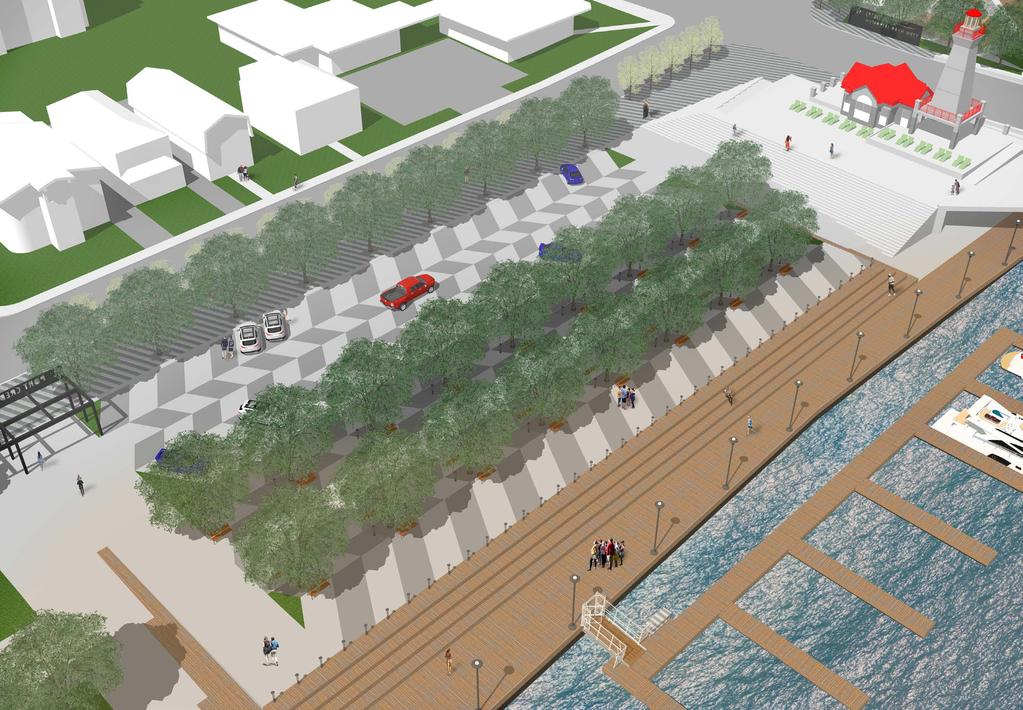
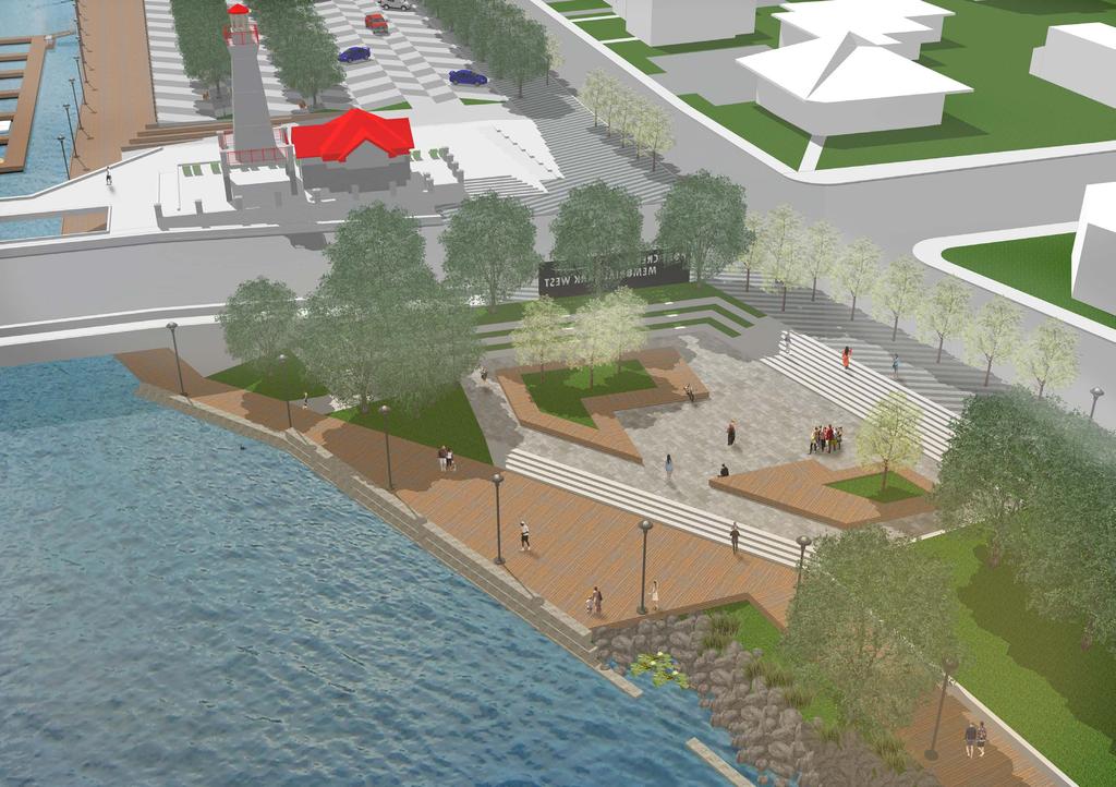
6 Concept 1 Layout RETAIN EXISTING NATURALIZED SLOPE IMPROVED STREETSCAPE NON-MOTORIZED LAUNCH RAMP CAR-TRAILER PARKING FRONT STREET SOUTH IMPROVED STREETSCAPE PARKING/EVENT SPACE LAKESHORE ROAD WEST PARKING FRONT STREET NORTH LAWN NATURALIZATION LAWN LOOKOUT THE DON ROWING CLUB OF MISSISSAUGA RAMP NATURALIZATION IMPROVED COASTAL EDGE MISSISSAUGA CANOE CLUB RAMP LAWN CIVIC PLAZA CREDIT RIVER SHADE STRUCTURE CREDIT RIVER SECURED CHARTER BOAT DOCKS FISH CLEANING STATIONS LOOKOUT CONCEPT 1: BUILDING ON THE EA PORT CREDIT HARBOUR WEST PARKS - PRELIMINARY CONCEPTS
7 Concept 1 Perspective
8 Concept 1 Cross Section PRESERVED TREE SHADE STRUCTURE IMPROVED COASTAL EDGE GRANULAR LAUNCH RAMP OFFLINE ZONE PARKLAND QUEING BIOSWALE CAR-TRAILER EXIT CAR-TRAILER ANGLED PARKING CAR-TRAILER ENTER IMPROVED STREETSCAPE/ WATERFRONT TRAIL PARALLEL PARKING N BOUND S BOUND EXISTING STREETSCAPE 2.5 m 3.5 m 3.5 m FRONT STREET S 9.5 m SOUTH SECTION - WEST PARKS MARINA PARK: CONCEPT 1


9 Concept 1 - Table of Features What do you think? Concept Elements Example Image Please indicate your support. Concept Elements Example Image Please indicate your support. Lookout Naturalization Shade Structure Improved Coastal Edge River Promenade Improved Streetscape Fish Cleaning Stations Non-motorized Launch Ramp Secured Charter Boat Docks Car-Trailer Parking Civic Plaza Parking / Event Space


10 Concept 2 Layout RETAIN EXISTING NATURALIZED SLOPE SMALL INFORMAL AMPHITHEATRE ELEVATED LANDING AND BRIDGE REORIENTATION NON-MOTORIZED LAUNCH RAMP IMPROVED STREETSCAPE PARK GATEWAY PARKING/EVENT SPACE LAKESHORE ROAD WEST IMPROVED STREETSCAPE FRONT STREET NORTH LAWN LAWN NATURALIZATION MISSISSAUGA CANOE CLUB RAMP FRONT STREET SOUTH LOOKOUT IMPROVED COASTAL EDGE THE DON ROWING CLUB OF MISSISSAUGA RAMP LAWN CIVIC PLAZA PLANTED TERRACING NATURALIZATION CREDIT RIVER CHARTER BOAT ACCESS ROUTE WAVE BREAK FISH CLEANING STATION SECURED CHARTER BOAT DOCKS CREDIT RIVER LOOKOUT CONCEPT 2: CHARTER BOATS RELOCATED SOUTH & MOTORIZED BOAT LAUNCH REMOVED PORT CREDIT HARBOUR WEST PARKS - PRELIMINARY CONCEPTS
11 Concept 2 Perspective


12 Concept 2 Cross Sections PRESERVED TREES LAKESHORE WEST BRIDGE CREDIT RIVER IMPROVED COASTLINE EDGE STEPS CIVIC PLAZA STEPS IMPROVED STREETSCAPE/ MULTIUSE TRAIL PARALLEL PARKING 2.5 m N BOUND 3.25m 3.25 m RIGHT TURN 3 m EXISTING SIDEWALK PC MEMORIAL PARK WEST - WEST PARKS CIVIC PLAZA: CONCEPT 2 FRONT STREET N PRESERVED TREE PRESERVED TREE PRESERVED TREE SHORELINE PROTECTION EDGE RIVER PROMENADE PLANTED TERRACING TERRACED PATH UPPER LAWN IMPROVED STREETSCAPE/ MULTIUSE TRAIL PARALLEL PARKING N BOUND 2.5 m 3.5 m S BOUND 3.5 m EXISTING STREETSCAPE NORTH SECTION - WEST PARKS MEMORIAL PARK: CONCEPT 2 FRONT STREET N 9.5 m


13 Concept 2 Cross Sections IMPROVED COASTAL EDGE PEDESTRIAN ZONE/CHARTER BOAT ACCESS PLANTED TERRACING CONCRETE PATH RAISED NATURALIZED PLANTER IMPROVED STREETSCAPE/ WATERFRONT TRAIL PARALLEL PARKING N BOUND 2.5 m 3.5 m S BOUND 3.5 m EXISTING STREETSCAPE FRONT STREET S 9.5 m SOUTH SECTION - WEST PARKS MARINA PARK: CONCEPT 2 SECURED CHARTER BOAT DOCKS RIVER PROMENADE DECKED SEATING EDGE PEDESTRIAN ZONE/CHARTER BOAT ACCESS ROUTE SHADED PEDESTRIAN TERRACE ANGLED PARKING PARKING ACCESS WAY ANGLED PARKING IMPROVED STREETSCAPE/ WATERFRONT TRAIL PARALLEL PARKING N BOUND S BOUND EXISTING STREETSCAPE NORTH SECTION - WEST PARKS MARINA PARK: CONCEPT m 6 m PARKING/MULTI USE EVENT AREA 17 m 5.5 m 2.5 m 3.5 m 3.5 m FRONT STREET S 9.5 m


14 Concept 2 - Table of Features What do you think? Concept Elements Example Image Please indicate your support. Concept Elements Example Image Please indicate your support. Lookout Civic Plaza Charter Boat Access Route Planted Terracing / Raised Naturalized Planter Wave Break Small Informal Amphitheatre Fish Cleaning Station Improved Streetscape Secured Charter Boat Docks Elevated Landing and Bridge Reorientation River Promenade Parking / Event Space Park Gateway Lawn Non-Motorized Launch Ramp Motorized Boat Launch Removed Charter Boats Relocated South


15 Concept 3 RETAIN EXISTING NATURALIZED SLOPE SMALL INFORMAL AMPHITHEATRE ELEVATED LANDING AND BRIDGE REORIENTATION IMPROVED STREETSCAPE PARK GATEWAY PARKING/EVENT SPACE FRONT STREET SOUTH LAKESHORE ROAD WEST IMPROVED STREETSCAPE FRONT STREET NORTH LAWN LAWN LOOKOUT NATURALIZATION IMPROVED COASTAL EDGE MISSISSAUGA CANOE CLUB RAMP THE DON ROWING CLUB OF MISSISSAUGA RAMP LAWN PLANTED TERRACING NATURALIZATION CREDIT RIVER CIVIC PLAZA SHORT TERM PUBLIC DOCKING NON-MOTORIZED LAUNCH RAMP CREDIT RIVER LOOKOUT CHARTER BOATS RELOCATED ACROSS RIVER FOR IMPROVED WATER SAFETY AND SECURITY CONCEPT 3: CHARTER BOATS & MOTORIZED BOAT LAUNCH RAMP REMOVED PORT CREDIT HARBOUR WEST PARKS - PRELIMINARY CONCEPTS


16 UTILITIES APPROX. 12 M HIGH Concept 3 Cross Sections PRESERVED TREE IMPROVED STREETSCAPE/ WATERFRONT TRAIL PARALLEL PARKING 2.5 m NORTH BOUND 3.5 m SOUTH BOUND 3.5 m EXISTING SIDEWALK PROPOSED ROADWAY 9.5 m SOUTH SECTION - WEST PARKS ROADWAY AND WATERFRONT TRAIL EXISTING ROADWAY 12 m FRONT STREET S IMPROVED COASTAL EDGE GRASS TERRACES WITH CONCRETE SEAT WALLS CONCRETE PATH IMPROVED STREETSCAPE/ WATERFRONT TRAIL PARALLEL PARKING N BOUND S BOUND EXISTING STREETSCAPE PLANTED TERRACING 2.5 m 3.5 m 3.5 m FRONT STREET S 9.5 m SOUTH SECTION - WEST PARKS MARINA PARK: CONCEPT 3

17 Concept 3 Front Street - Street View Perspective


18 Service Access Naturalization Parking/Large Event Flex Space Parking Area Open Green Space Multi-use Civic Space Existing Building Most Recent Sediment Removal Sculling Boats Rowing Club MARINA PARK PORT CREDIT MEMORIAL PARK (WEST) N t S Potential Conflict Zone Motorized Boat Traffic Non-Motorized Boat Traffic Canoe Club t n Fro Motorized Boat Launch Non-Motorized Boat Launch Rivergate Easement Natural Shore Edge Hard Shore Edge Streetscape Enhancement Lookout Project Boundary Vehicular Circulation On-Road Cycling Waterfront Trail Trail LEGEND Rivergate apartment Lighthouse Non-Motoized Boats Credit River Motor Boats Charter Boats Lakeshore Rd W Seasonal + Vistor Motor Boats Circulation HARBOUR WEST PARKS Front St S


19 Concept 3 - Table of Features What do you think? Concept Elements Example Image Please indicate your support. Concept Elements Example Image Please indicate your support. Lookout Improved Streetscape Relocated Charter Boats Parking / Event Space River Promenade Elevated Landing and Bridge Reorientation Non-Motorized Launch Ramp Park Gateway Short Term Public Docking Small Informal Amphitheatre Civic Plaza Lawn Planted Terracing Naturalization
Mississauga Waterfront. Parks Strategy - Draft
 Potential configuration for river s edge seating. Boating on Credit River: A regatta Boating on Credit River: Active enjoyment 5.2 Port Credit Memorial Park West Priority Park 5.2.1 Site Opportunities
Workshop 3. City of Burlington Waterfront Hotel Planning Study. September 14, The Planning Partnership
 Workshop 3 City of Burlington Waterfront Hotel Planning Study September 14, 2017 The Planning Partnership The Waterfront Hotel Planning Study 01 The Brant & Lakeshore Planning Study will establish a Strategic
Waterfront Development Master Plan
 PORT of VANCOUVER USA Vancouver, WA Waterfront Development Master Plan DRAFT - FINAL CONCEPTUAL MASTER PLAN PROJECT TEAM NBBJ Heritage Research Associates JLA Kittelson Associates Leland Consulting Group
Table 8-4: Road Classification Local Roads, second table, of Chapter 8 Create a Multi-Modal City, be amended by adding the following:
 1 Port Street East Official Plan Amendment APPENDIX 3 Amendments to Mississauga Official Plan Table 8-4: Road Classification Local Roads, second table, of Chapter 8 Create a Multi-Modal City, be amended
4 Study Findings. Port Credit District. Port Credit District
 4 Study Findings Section 4 Study Findings: Port Credit contains the district vision statement, a summary of public input (including stakeholder input) and a series of recommendations for public policies
LAKEVIEW VILLAGE VISION & MASTERPLAN PRESENTATION TO CITY OF MISSISSAUGA. April 9, 2018
 LAKEVIEW VILLAGE VISION & MASTERPLAN PRESENTATION TO CITY OF MISSISSAUGA April 9, 2018 AGENDA Introduction Vision Plan Comparison The Big Moves Trail Connections Plan Overview Districts Conveyance Comparison
JACKsON STREET PIER CONCEPTUAL DESIGN PACKAGE SEPTEMBER 21, 2017
 JACKsON STREET PIER CONCEPTUAL DESIGN PACKAGE SEPTEMBER 21, 2017 JACKsON STREET PIER Process outline DESIGN PROCESS OVERVIEW: Sandusky s Jackson Street Pier Conceptual Design process included input from
Inspiration Port Credit. Exploring the Options Public Engagement March 26, 2013
 Inspiration Port Credit Exploring the Options Public Engagement March 26, 2013 Port Credit Port Credit Foundations Change has been happening in Port Credit for years. Source: City of Mississauga, Mississauga
Online Survey Results 1 Port Street East
 Online Survey Results 1 Port Street East Inspiration Port Credit is about envisioning a bright, new future for the Port Credit waterfront. Through an online survey in the fall of 2014, we asked what the
BRADENTON RIVERWALK EXPANSION MASTER PLAN
 BRADENTON RIVERWALK EXPANSION MASTER PLAN INTRODUCTION & AGENDA Process Update Community Engagement Summary Center for Active Design (CfAD) Recommendations Context and Existing Conditions Master Plan Alternatives
Chairman and Members of the Planning and Development Committee. Thomas S. Mokrzycki, Commissioner of Planning and Building
 LA.09.TOR (Toronto) DATE: TO: FROM: SUBJECT: Chairman and Members of the Planning and Development Committee Thomas S. Mokrzycki, Commissioner of Planning and Building Central Waterfront Secondary Plan
Welcome! HORSESHOE BAY PARK. Welcome!
 Welcome! HORSESHOE BAY PARK Welcome! Where are we in the process? Today we would like your input on how Horseshoe Bay Park can be upgraded to serve the community s needs better. CONSULT STAKEHOLDERS TAKE
Workshop #3 June 13, 2016
 Downtown Ocoee Master Plan Workshop #3 June 13, 2016 Our Team Our Team and Tonight s Goal Quick Recap: Why a Downtown Plan? How are we developing the plan? How can you still be involved? What s left to
Welcome. Community Consultation Meeting November 28, Review and discuss the Bathurst Quay Neighbourhood Plan Framework
 Welcome Community Consultation Meeting November 28, 2016 Why Are We Here Today? Review and discuss the Bathurst Quay Neighbourhood Plan Framework Review and discuss an Action Plan for Implementation Next
City of Plattsburgh DRI: Downtown Streetscapes & Riverfront Access. Downtown Streetscape and Riverfront Access Design
 City of Plattsburgh DRI: Downtown Streetscapes & Riverfront Access Welcome Thank you for coming this evening. Agenda PART I - Project Context The Downtown Revitalization Program Our DRI Projects Other
APPENDIX K WINDSOR OFFICIAL PLAN
 CEAA ENVIRONMENTAL ENVIRONMENTAL IMPACT ASSESSMENT AMBASSADOR BRIDGE ENHANCEMENT PROJECT Replacement Span and Plaza Expansion APPENDIX K WINDSOR OFFICIAL PLAN Avalon Consulting Professionals of Ontario,
Glen Road Pedestrian Bridge Environmental Assessment
 Glen Road Pedestrian Bridge Environmental Assessment Presentation to Design Review Panel July 18, 2017 Glen Road Pedestrian Bridge Class Environmental Assessment STUDY AREA Bloor Street East Streetscape
Ashbridges Bay Erosion and Sediment Control Project
 Ashbridges Bay Erosion and Sediment Control Project Project Brief Overview Toronto and Region Conservation Authority, in partnership with the City of Toronto, intends to carry out remedial erosion control
CITY OF VAUGHAN D R A F T YONGE STREET STUDY. June 2008 YOUNG + WRIGHT /IBI GROUP ARCHITECTS DILLON CONSULTING LTD.
 CITY OF VAUGHAN June 2008 YOUNG + WRIGHT /IBI GROUP ARCHITECTS GHK SUSTAINABILITY INTERNATIONAL + LIVABILITY (CANADA) LTD. = COMMUNITY VALUE DILLON CONSULTING LTD. Public Open House Tonight s Meeting WELCOME
City of Poughkeepsie Waterfront Redevelopment Strategy. Poughkeepsie Waterfront Redevelopment Strategy
 City of Poughkeepsie Waterfront Redevelopment Strategy Poughkeepsie Waterfront Redevelopment Strategy City of Poughkeepsie Prime Assets: Major Waterfront Advantages: - Central City of the Hudson River
Lakeview and Port Credit District Policies Review Public Engagement Process
 Lakeview and Port Credit District Policies Review Public Engagement Process Brook McIlroy Planning + Urban Design/PACE Architects MSAi Architects Poulos and Chung Transportation Engineers December 11,
lakeway mixed use tract open space plan
 LEGEND:. UNDISTURBED NATURAL AREA. ENTRY STATEMENT BUILT INTO HILLSIDE. R.O.W. PLANTING (STREET TREES/LIGHTS). HEB ENTRY DRIVE 5. BIO-FILTRATION IN MEDIAN 6. MAIN ENTRY @ MAIN STREET. EXISTING TREES TO
Please read the entire document
 projects impacting the waterfront revitalization area. The waterfront revitalization area of the town will have to subareas to the west and east of the village. Page 6 of 6 Wayfinding master plan create
ROME WATERFRONT VILLAGE PROJECT NARRATIVE January 25, 2018
 January 25, 2018 The Rome Waterfront Village project is intended to foster the revitalization of the area between South James Street and Erie Boulevard north of the Erie Canal as well as improve public
Public Meeting #3 May 9, 2009 MVVA Team
 Public Meeting #3 May 9, 2009 MVVA Team Welcome to the third Public Meeting for the Lower Don Lands Municipal Class Environmental Assessment (EA) Infrastructure Master Plan and Keating Channel Precinct
Purpose of Open House #3
 Public Meeting #3 May 9, 2009 MVVA Team Purpose of Open House #3 The main purpose of this Open House is to present and seek input on the: Evaluation of transportation and infrastructure design alternatives
Baselands Trails Master Plan Public Meeting. April 28, 2015 Fire Academy, 895 Eastern Avenue, Toronto 6:30 p.m. to 9:00 p.m.
 Baselands Trails Master Plan Public Meeting April 28, 2015 Fire Academy, 895 Eastern Avenue, Toronto 6:30 p.m. to 9:00 p.m. Baselands Trails Master Plan Meeting Purpose To present and get feedback on:
North Shore Trail. Council Meeting June 10, 2002
 North Shore Trail Council Meeting June 10, 2002 Process Guiding Principles Inventory and Analysis Preliminary Concepts (4) Final Concept Phasing Strategy Estimated Costs OVERVIEW Purpose: Prepare an overall
Hamilton Pier 7&8 Public Meeting and Workshop #1
 Hamilton Pier 7&8 Public Meeting and Workshop #1 May 12, 2015 May 01, 2015 Meeting Agenda 6:30 Doors Open 6:30-6:45 Review Boards 6:45-7:10 Introductions and Presentation Study Overview Policy Background
1 Port Street East: Delivering on the Vision. Andrew Whittemore Director, City Planning Strategies. Ruth Marland. TOPCA May 23, 2017
 1 Port Street East: Delivering on the Vision Andrew Whittemore Director, City Planning Strategies Ruth Marland TOPCA May 23, 2017 Strategic Leader, City Planning Strategies Mary Ellen Bench City Solicitor
burlington mobility hubs study Downtown Burlington Mobility Hub
 burlington mobility hubs study Downtown Burlington Mobility Hub Draft Precinct Plan Workbook PIC #3, September 7, 2017 downtown mobility hub objectives City staff and their consultants are proposing an
Welcome. Tannery and Waterworks Parks Shoreline Improvements Environmental Assessment. Public Information Centre #1 November 27, pm to 8 pm
 Welcome Tannery and Waterworks Parks Shoreline Improvements, Environmental Assessment Tannery and Waterworks Parks Shoreline Improvements Environmental Assessment #1 6 pm to 8 pm Why We Are Here Tannery
Community Conversation. Thursday, March 30, James St N 7:00 pm 9:15 pm
 Community Conversation Thursday, March 30, 2017 294 James St N 7:00 pm 9:15 pm Start Time Agenda item Presenter / Facilitator 7:00 Welcome & Agenda Overview Diedre Rozema (City of Hamilton) Participation
Public Consultation Summary: Lakeview Place Making Workshop January 30, 2008.
 Page 1 of 11 Public Consultation Summary: Lakeview Place Making Workshop January 30, 2008. 1.0 Introduction: On January 30, 2008 the City of Mississauga, in conjunction with the consulting team of Brook
SALEM FOREST RIVER PARK PRELIMINARY POOL AREA ASSESSMENT & MASTER PLAN STUDY. For the City of Salem
 SALEM PRELIMINARY POOL AREA ASSESSMENT & MASTER PLAN STUDY For the City of Salem 6-13-17 This process undertaken by Weston & Sampson is to outline preliminary ideas only of what possibilities exist for
PUBLIC REALM STUDY AREA
 WELCOME PUBLIC REALM STUDY AREA WHAT IS PUBLIC REALM? Welcome to the Ballina Town Public Realm public consultation event. Mayo Council is in the process of producing a Public Realm Strategy for Ballina
5.0 P A R K R E C O M M E N D A T I O N S
 5.0 P A R K R E C O M M E N D A T I O N S 5.1 Confederation Park The analysis of Confederation Park recognizes that it, along with City Hall, is the symbolic heart of Kingston. While the existing layout
Bathurst Quay Neighbourhood Plan. Community Consultation Meeting November 28, 2016
 Bathurst Quay Neighbourhood Plan Community Consultation Meeting November 28, 2016 1 Tonight s Agenda Background A Neighbourhood Plan for Bathurst Quay An Action Plan for Success Policy Directions and Next
Scarborough Waterfront Project
 Scarborough Waterfront Project Public Information Centre #1 Environmental Assessment Terms of Reference September 10, 2014 Agenda Open House Presentation 7:00 to 7:30 pm Presentation 7:30 to 8:15 pm History
VEHICULAR AND PEDESTRIAN CIRCULATION
 This perspective sketch communicates the intended character and quality of a proposed streetscape design. Locate benches near a major intersection where people tend to gather. Seating and lighting provide
APPENDIX L3. Table of Contents. SWP EA Information Sheets
 E N V I R O N M E N T A L A S S E S S M E N T APPENDIX L3 SWP EA Information Sheets Table of Contents EA Info Sheet 1... L3-1 EA Info Sheet 2... L3-3 EA Info Sheet 3... L3-5 EA Info Sheet 4... L3-7 SCARBOROUGH
GLEN ROAD PEDESTRIAN BRIDGE ENVIRONMENTAL ASSESSMENT STUDY PUBLIC INFORMATION CENTRE #2 OCTOBER 24, 2017
 GLEN ROAD PEDESTRIAN BRIDGE ENVIRONMENTAL ASSESSMENT STUDY PUBLIC INFORMATION CENTRE #2 OCTOBER 24, 2017 Glen Road Pedestrian Bridge Class Environmental Assessment 1 WELCOME! Welcome to the second Public
OPPORTUNITIES AND CONSTRAINTS - OXBOW PARK ENTRANCE AND PUT-IN
 OPPORTUNITIES AT OXBOW EXISTING WETLANDS Site is undeveloped and we can design a park that works well from the start. SAND BEACH Potential to eliminate invasive species. DEBRIS (CONCRETE, OLD CARS) VEGETATION
WELCOME Tuesday, May 29th 6:30-9:00 p.m. Waterside Inn Port Credit, Mississauga
 One Port Street Community Consultation Session #1 WELCOME Tuesday, May 29th 6:30-9:00 p.m. Waterside Inn Port Credit, Mississauga Agenda 6:30 Welcome & Opening Remarks 6:50 Presentation 7:30 Roundtable
I-90 ALLSTON INTERCHANGE A MULTIMODAL TRANSPORTATION PROJECT PUBLIC INFORMATION MEETING SEPTEMBER 18, 2014 JACKSON MANN COMMUNITY CENTER
 I-90 ALLSTON INTERCHANGE A MULTIMODAL TRANSPORTATION PROJECT PUBLIC INFORMATION MEETING SEPTEMBER 18, 2014 JACKSON MANN COMMUNITY CENTER 1 Project Need Deteriorating viaduct requiring replacement All Electronic
CHAPTER 5 Public Realm Improvements
 5.1 OVERVIEW This chapter focuses on the public realm, that is, spaces within and directly adjacent to public rights-of-way (ROWs), including streets, Oso Creek, the rail corridor, and the freeway edge.
Mark-up of the effect of the proposed Bronte Village Growth Area OPA No.18 on the text of section 24, Bronte Village, of the Livable Oakville Plan
 Mark-up of the effect of the proposed Bronte Village Growth Area OPA No.18 on the text of section 24, Bronte Village, of the Livable Oakville Plan Notes: This document is provided for information purposes
The Master Plan Framework
 The Master Plan Framework The East Harbour Master Plan advances the development of 60 acres of former industrial lands east of the Don River. The Master Plan outlines a vision for a vibrant, transit-oriented
Don Mills Crossing Study and Celestica Lands Development Application Community Meeting, Open House, and Breakout Discussions
 Consultation Summary Don Mills Crossing Study and Celestica Lands Development Application Community Meeting, Open House, and Breakout Discussions This report is not intended to provide a verbatim transcript
Cold Lake Marina Master Plan
 Cold Lake Marina Master Plan Intro to Team Moffatt & Nichol is recognized throughout the world for our role in the revitalization and redevelopment of urban waterfronts, including the evolution of modern
Mississippi Drive Corridor Revitalization. A DestinationTransportation Project...
 Mississippi Drive Corridor Revitalization A DestinationTransportation Project... Mississippi Drive Corridor Revitalization Welcome! Tonight s Agenda: Further define the Scope of the Project Discuss the
Stakeholders Advisory Working Groups (SAWGs) Smart Growth and TOD Land Use (#11) SAWG Meeting
 Smart Growth and TOD Land Use (#11) SAWG Meeting") Presentation - Part II Tappan Zee Bridge/I-287 Corridor Project July 21, 2010 Slide 1. David Kooris (Regional Plan Association) welcomed members of the Land Use Stakeholders Advisory Working Groups (SAWGs)
Presentation - Part II Tappan Zee Bridge/I-287 Corridor Project July 21, 2010 Slide 1. David Kooris (Regional Plan Association) welcomed members of the Land Use Stakeholders Advisory Working Groups (SAWGs)
Emerson Park Master Plan Update. Public Meeting III August 27, 2014
 Emerson Park Master Plan Update Public Meeting III August 27, 2014 Meeting Agenda: Project Update Presentation of Master Plan Components Discussion and Feedback The Path Forward: Building on the Concept
NORTH LAKE SPECIFIC PLAN AREA
 NORTH LAKE SPECIFIC PLAN AREA June 21, 2018 WELCOME Workshop Agenda Introduction Provide information about the program and introduce the team Background Information Share information about the North Lake
Adelaide Street / Canadian Pacific Railway (CPR) Grade Separation. Public Information Centre #1
 Grade Separation. Public Information Centre #1") 1 Adelaide Street / Canadian Pacific Railway (CPR) Why Are We Here? 2 The purpose of Public Information Centre (PIC) #1 is to: Introduce the study Provide the study background and context Identify the
1 Adelaide Street / Canadian Pacific Railway (CPR) Why Are We Here? 2 The purpose of Public Information Centre (PIC) #1 is to: Introduce the study Provide the study background and context Identify the
Naomi Weiss, Executive Director, DBPA Jason Jeffries, Project Manager, City of Daytona Beach
 Naomi Weiss, Executive Director, DBPA Jason Jeffries, Project Manager, City of Daytona Beach Nottingham Plan 2002 Adopted Redevelopment Plan 2002 Riverfront Action Plan 2004 Downtown Vision Plan 2007
Ringsend & Irishtown Local Environmental Improvement Plan
 Ringsend & Irishtown Local Environmental Improvement Plan Study Area East Link Bridge St. Patrick s Boat Club Ringsend Technical Institute Stella Maris Boat Club St. Patrick s Church Ringsend Library Ringsend
WHAT WE LEARNED FROM YOU
 PUBLIC CONSULTATION SUMMARY WHAT WE LEARNED FROM YOU Prepared By: in conjunction with: Poulos and Chung Ltd. Terraprobe Baird and Associates Philips Engineering Ltd. City of Mississauga Waterfront Parks
Sub-committee on Harbour Plan Review of Harbour-front Enhancement Committee. Ninth Meeting
 Sub-committee on Harbour Plan Review of Harbour-front Enhancement Committee Ninth Meeting Date: 5 October 2005 Time: 3:30pm Venue: Conference Room 15/F, North Point Government Offices, 333 Java Road, North
Lynn Waterfront Master Plan
 Lynn Waterfront Master Plan DECEMBER ALTERNATIVES PRESENTATION City of Lynn / EDIC ZHA / GEI Work Schedule June Kick-Off June September Site Analysis & Property Owner / Stakeholder Meetings September Analysis
City of Burlington Official Plan Review: Indian Point Character Area Study. April 2, 2013 Public Visioning Workshop
 City of Burlington Official Plan Review: Indian Point Character Area Study April 2, 2013 Public Visioning Workshop Tonight s Schedule 6:30 6:35 City s Introduction 6:35 7:05 Consultant Presentation 7:05
Thank you for coming to the Rail Corridor Land Use Study Public Meeting.
 01 Welcome! Thank you for coming to the Rail Corridor Land Use Study Public Meeting. Tonight is an opportunity to learn about the Land Use Study for the Rail Corridor Site. In Fall 2016, Toronto City Council
PORT OF VANCOUVER WATERFRONT DEVELOPMENT. Concept Development Plan City Center Redevelopment Authority April 20, 2017
 PORT OF VANCOUVER WATERFRONT DEVELOPMENT Concept Development Plan City Center Redevelopment Authority April 20, 2017 Port History PORT ESTABLISHED 1912 TERMINAL 1 ACQUIRED 1925 GWM SIGNS LEASE 1935 HARBOR
PHASE 3-4 PARKS SOUTH PARK AND CHANNEL PARK
 PHASE 3-4 PARKS SOUTH PARK AND CHANNEL PARK Sheet List L1.0 L2.0 L3.0 L4.0 L5.0 L6.0 L7.0 L8.0 L9.0 L10.0 L11.0 L12.0 L13.0 L14.0 L15.0 L16.0 L17.0 L18.0 L19.0 L20.0 L21.0 L22.0 Cover Open Space Context
Mavis Road Class Environmental Assessment
 Mavis Road Class Environmental Assessment Public Information Centre #2 Wednesday November 9, 2016 6:00 to 8:00 p.m. Please sign in and complete a comment sheet Review the displays on your own or join in
ALTERNATIVE STATION AREA -
 ALTERNATIVE STATION AREA - THE 10 TH STREET GARDEN STATION Two alternative land use scenarios and designs are illustrated here: Scheme A - Transit-Oriented Development High to Mid-Density Residential /Office
MEETING MINUTES. Attendees
 Page 1 of 9 MEETING MINUTES Subject: Bayfront Industrial Area Renewal Strategy Focus Group Meeting #2 Date and Time: Thursday, May 24, 2018 4:00 p.m.-6:30 p.m. Location: The Eva Rothwell Centre, Boardroom,
HUMBER BAY PARK PROJECT - BUILDING CONCEPT
 WELCOME 1 Humber Bay Park, with its system of trails, rugged shoreline, and dramatic views, is a unique and rare waterfront experience within the larger metropolitan Toronto area offering a place for quiet,
Town of Whitby Waterfront Parks and Open Space Master Plan Final Report, January 2016
 CMS 20-16 Attachment #1 Town of Whitby Waterfront Parks and Open Space Master Plan Final Report, January 2016 Table of Contents Waterfront Master Plan Study Overview i Introduction 1 Overall Waterfront
City Center Neighborhood Plan
 [1] City Center Neighborhood Plan As adopted by Ordinance No. 2014-09-049 and amended by Ordinance Nos. Formerly CBD Neighborhood as adopted by Ordinance No. 8868 and amended by Ordinance Nos. 8946, 9693,
Lambeth Main Street Streetscape Improvements
 Lambeth Main Street Streetscape Improvements Open House October 5th, 2017 Agenda 1. Introduction 2. Project Background 3. Context 4. Project Objectives 5. Design Principles & Approach 6. Streetscape Design
BATHURST QUAY NEIGHBOURHOOD PLAN IMPLEMENTATION. Streetscape & Public Realm Improvement Plan - Canada Malting Silo Site and Eireann Quay
 BATHURST QUAY NEIGHBOURHOOD PLAN IMPLEMENTATION Streetscape & Public Realm Improvement Plan - Canada Malting Silo Site and Eireann Quay Bryan Bowen, Waterfront Secretariat November 25, 2017 Presentation
A. Selma Park, Davis Bay and Wilson Creek
 A. Selma Park, Davis Bay and Wilson Creek This waterfront neighbourhood consists of three separate community areas, linked by Highway 101, but with different character, land use patterns and future potential.
PORT CREDIT MEMORIAL ARENA
 March 24, 2009 Heritage Committee The Team & Schedule Team owned/operated facility ZAS Architects John George Landscape Architect Halsall Structural Engineers Jain and Associates Mechanical and Electrical
Pointe-Claire Community Destination
 Pointe-Claire Community Destination Lester John Vidal Sarah Gregoire-Caucci Gabriel Van Beverhoudt APRIL 2011 Table of Content 1. Executive Summary Problems & Solutions Current State Approach 2. Program
Transportation Master Plan Environmental Assessment
 Transportation Master Plan Environmental Assessment AUGUST, 2014 Waterfront Toronto / Perkins + Will Lower Yonge Transportation Master Plan Environmental Assessment Contents Executive Summary 1 1 Introduction
Public Workshop 2 December 11, 2014 OLIN
 Public Workshop 2 December 11, 2014 OLIN TRIPLE IMAGE PANORAMA A NEW VISION FOR THE RIVERFRONT PROMENADE Burlington s Riverfront has historically been a defining character of the City s identity. This
Toronto Complete Streets Guidelines
 c. DTAH 58 60 3.1 70 3.2 Performance Measurement 71 3.3 Exceptions Chapter 3 describes the five general steps in the street design process. Not all projects follow these steps, as the number of steps and
Fifth and Detroit Street Design May 2017 Capital Improvements Committee. DOWNTOWN Street Design
 1 Fifth and Detroit Street Design May 2017 Capital Improvements Committee Agenda 2 Review Street Configuration Prior Meeting Review Outreach Synopsis Functional Street Design Refinements Curb Edge, Turning
Lynn Waterfront Master Plan
 Lynn Waterfront Master Plan Public Meeting #2 December 10th, 2018 1 Project Schedule Update September 26, 2018 December 10, 2018 Development of the Master Harbor Plan Amendment and Revised Waterfront Master
AMBLESIDE WATERFRONT
 Overview: An Integrated Vision for the Waterfront The waterfront concept plan shown above is the result of 40 years of acquiring, planning and improving a publicly-owned waterfront. Consistent community
Derby-Shelton Bridge Pedestrian and Bicyclist Enhancements [1]
![Derby-Shelton Bridge Pedestrian and Bicyclist Enhancements [1]](/thumbs/96/128011958.jpg "Derby-Shelton Bridge Pedestrian and Bicyclist Enhancements [1]") nhancements [1] STATUS OF PROJECT: The project has recently moved from the Preliminary Design Phase to the Final Design Phase following the most recent Public Involvement Meeting held on January 9, 2019
nhancements [1] STATUS OF PROJECT: The project has recently moved from the Preliminary Design Phase to the Final Design Phase following the most recent Public Involvement Meeting held on January 9, 2019
Cleveland Park Streetscape and Drainage Improvement Project 1
 Cleveland Park Streetscape and Drainage Improvement Project 1 Urban Context Washington, D.C. Connecticut Avenue Cleveland Park Streetscape and Drainage Improvement Project 2 Neighborhood Context Contributing
IMAGINE CLEARWATER. Community Workshop 3. November 2016
 IMAGINE CLEARWATER Community Workshop 3 November 2016 Imagine Clearwater has been a 6-month community-focused process to re-envision the downtown waterfront. VISIONING FRAMEWORK MASTER PLAN HOW CAN WE
PORT WHITBY COMMUNITY
 PORT WHITBY COMMUNITY SECONDARY PLAN UPDATE COMMUNITY IMPROVEMENT PLAN URBAN DESIGN GUIDELINES September 2015 DRAFT PROPOSED AMENDMENT NUMBER # to the Whitby Official Plan PURPOSE: The intent of this Amendment
MEMORANDUM. This memo deals with proposed amendments to previously issued Development Permit No for Park Royal North.
 MEMORANDUM Date: August 28, 2015 Our File: 1010-20-15-062 To: Design Review Committee From: Lisa Berg, Senior Community Planner Re: Amendment to Development Permit for Park Royal North This memo deals
Lakefront Downtown Action Plan Phase I June 2008
 Lakefront Downtown Action Plan Phase I June 2008 Downtown Development Authority City of Lake Charles Lakefront Overview DDA Chairman Rick Richard DPZ Lakefront Plan May 5 th 2007 $18.5M City Bond Issue
COW BAY DEVELOPMENT LANDS
 PRINCE RUPERT PORT AUTHORITY COW BAY DEVELOPMENT LANDS MARCH 28TH, 2012 % of Completion 0 25 50 75 100 4 guiding principles & OBJECTIVES COMMUNITY FEEDBACK BUSINESS & COW BAY MERCHANT FEEDBACK COMMUNITY
Illustrative Development Plan
 Illustrative Development Plan December 7, 005 045 Sansome St., Studio 3 San Francisco, CA 94 Area A - Increase visibility to waterfront and aquatic center from the Embarcadero - Provide streets rather
Notice of Preparation (NOP) of an Environmental Impact Report and Public Scoping Meeting for the Alameda Shipways Residential Project
 of an Environmental Impact Report and Public Scoping Meeting for the Alameda Shipways Residential Project") Notice of Preparation (NOP) of an Environmental Impact Report and Public Scoping Meeting for the Notice is hereby given that the City of Alameda, Lead Agency, will prepare an Environmental Impact Report
Notice of Preparation (NOP) of an Environmental Impact Report and Public Scoping Meeting for the Notice is hereby given that the City of Alameda, Lead Agency, will prepare an Environmental Impact Report
Highland Falls Waterfront Redevelopment Feasibility Study Village Board Meeting March 20, 2017
 Village Board Meeting March 20, 2017 Agenda I. Public Meeting #1 Visioning Summary II. Public Meeting #2 Comment Summary III. IV. IV. Case Study: Milton Train Station Schematic Design Concepts Schedule/Next
open house 3 CITY OF SALEM Downtown Streetscape Plan
 open house 3 Streetscape concepts CITY OF SALEM Downtown Streetscape Plan analysis concepts we are here refined concepts & document Feb 13th 1 2 3 apr 18th KICKOFF OPEN HOUSE Streetscape Work Group Walking
The purpose of tonight s PIC is to:
 The purpose of tonight s PIC is to: Provide an overview of the work completed to date and a summary of the Class EA process being followed; Provide a summary of public input received so far, including
Recreational Pathway Crossing of Richmond Street Municipal Class Environmental Assessment. Public Information Centre #2 April 22, 2015
 Recreational Pathway Crossing of Richmond Street Municipal Class Environmental Assessment Public Information Centre #2 April 22, 2015 1. Study Process PHASE 1 PHASE 2 PHASE 3 PHASE 1 : Problem/Opportunity
BEMIDJI CITY COUNCIL Work Session Agenda Monday July 9, 2012
 BEMIDJI CITY COUNCIL Work Session Agenda Monday July 9, 2012 City Hall Conference Room 5:30 p.m. 1. CALL TO ORDER / ROLL CALL 2. REVIEW PARK PLANS FOR PAUL BUNYAN PARK, LIBRARY PARK AND SOUTH SHORE BAUER
Waterlily Playscape Committee Waterlily Playscape, Waterlily Park, Ocean Shores Draft Concept Plan. G Issue D 14/07/16
 Waterlily Playscape Committee Waterlily Playscape, Waterlily Park, Ocean Shores Draft Concept Plan Issue D 14/07/16 New two level wharf for fishing and interacting with waters edge (exact location to be
Access Management: An Overview
 Figures 1-5 Below Evolution of development along a highway. In the early stages, land along the road is used for farming with little traffic generated. As time passes, the highway corridor becomes a de
Four Big Ideas. Three Key Opportunities. Principles. Draft Place Making Master Plan. 1. The Foreshore 2. Green Links. 3.
 project background Four Big Ideas 1. The Healthy Thriving Place. An International Focus 3. Reclaiming Mooloolaba 4. The Resort Heart of the Coast In November 01 a big ideas workshop was held involving
St. Clair Avenue West Area Transportation Master Plan
 1 (Between Keele Street and Old Weston Road) Public Information Centre 1 December 2, 2015 2 Welcome Welcome to the first Public Information Centre for the St. Clair Avenue West Area. The panels will present
WELCOME! 8 8:30 6: TH STREET IMPROVEMENTS. Open House. Presentation & Q&A
 WELCOME! 168 TH STREET IMPROVEMENTS 6:30 Open House 7 8 Presentation & Q&A 8 8:30 Open House WELCOME Todd Pfitzer City of Omaha Engineer Bob Stubbe City of Omaha Public Works Director Jon Meyer Project