Kanata Light Rail Transit Planning and Environmental Assessment Study
|
|
|
- Joseph Cobb
- 5 years ago
- Views:
Transcription

1 Kanata Light Rail Transit Planning and Environmental Assessment Study Public Open House #2 Transportation Services Department December 7, 2017
2 Agenda Review study progress Confirm the Preferred Corridor Design Alternatives Light Maintenance and Storage Facility Preliminary Recommended Plan Next Steps 1
 Strategic opportunity to review possibility of Stage 3 to extend service further west")
3 Context for the Study Confederation Line nearing completion (2018) Stage 2 Extension of Confederation Line West to Moodie and Baseline Stations is proceeding (2023) Strategic opportunity to review possibility of Stage 3 to extend service further west 2
4 Study Goals Determine the Preferred Corridor; Determine the Recommended Plan for LRT alignment and stations; and Determine project staging and implementation based on future ridership and affordability. 3
5 Study Schedule Pre-Planning Phase Spring 2017: Existing Conditions & Corridor Selection *Consultation Group Meetings* *Public Open House 1* EA Phase Summer/Fall 2017: Evaluation of Designs *Meet with Stakeholders and Consultation Groups* Spring 2018: Commence Transit Project Assessment Process Fall/Winter 2017: Recommended Plan *Consultation Group Meetings* *Public Open House 2* *Present to Committee and Council* 4
 Documented in Environmental Project Report")
6 Study Process Environmental Assessment requirements addressed through Transit Project Assessment Process (TPAP) Documented in Environmental Project Report (EPR) 5
7 What We Heard Expressed support for Corridor 8 Do not support Corridor 13 Consider how to provide a supporting transit network to better serve Kanata & Stittsville Extend corridor 8 beyond Canadian Tire Centre, towards Hazeldean How to cross Highway 417 Connectivity to stations Transit-Oriented Development potential Future ridership numbers 6
8 Confirm the Preferred Corridor 7
9 Additional Corridor Evaluation Further assessment of Corridors 1, 5, 8, 13 was undertaken Terminus modified in each corridor Evaluated new scenarios against same criteria used in initial evaluation Used ridership projections from City Transportation model All scenarios provide increased transit ridership versus the Transportation Master Plan Base Scenario (2031 Affordable Network) 8

10 Preferred Corridor - 8A Provides rapid transit spine, supports approved transit corridors, development patterns Good connection to Kanata North should be provided to enhance network Extension to Hazeldean further increases ridership, improves network connectivity and provides additional transit-oriented development opportunities Ridership Potential & Network Connectivity TOD & City Building Opportunities Natural Environment Impacts Social Environment Impact Complexity Capital & Operational Costs + + 9
11 Alternative Design Evaluation 10
12 Alternative Designs Generally, the LRT will follow the same alignment as previously approved Transitway EA s Alternative designs have been developed and evaluated for: March/Eagleson Station Terry Fox Station to Palladium segment 11
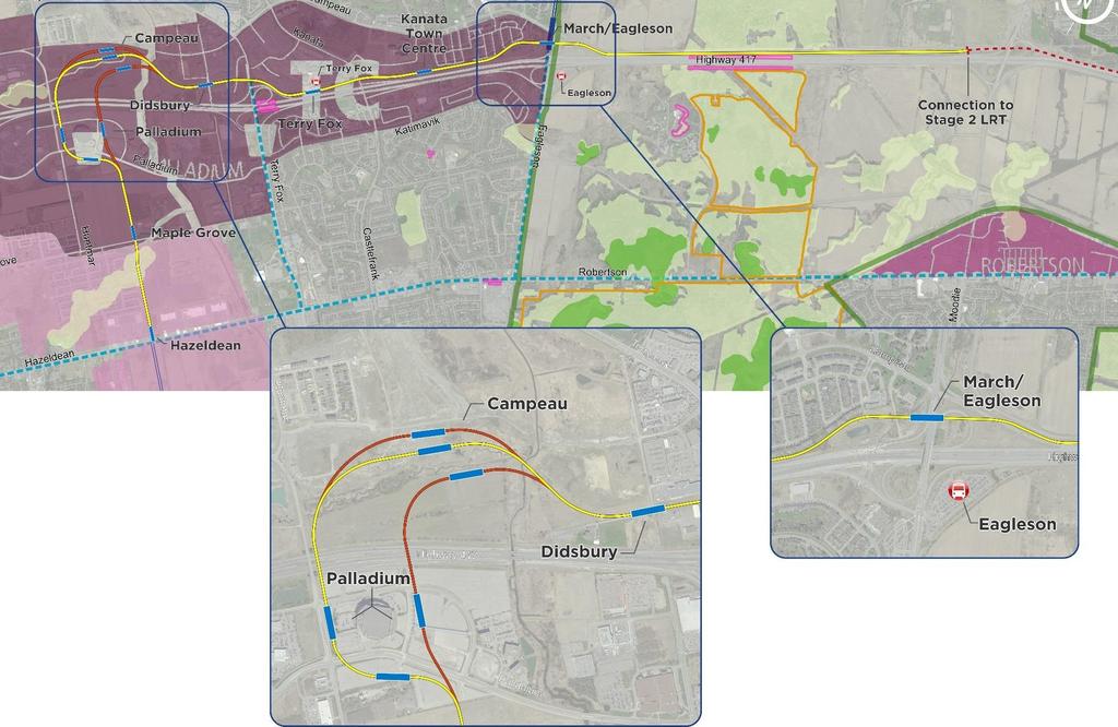
13 Alternative Designs 12

14 March/Eagleson Station LRT will follow previously studied and approved BRT alignment Main considerations in developing a preferred design at this location include: Station connectivity Transit/traffic operations Land use compatibility Cost 13
15 March/Eagleson Station Alternative 1 Limited impact to Ontario Provincial Police (OPP) facility Bus terminal / Passenger pick-up and drop-off adjacent to station Supports good station connectivity and access Impact to BRT connection 14

16 March/Eagleson Station Alternative 2 Maintains BRT connection Requires relocation of OPP facility Bus terminal is complex, and removed from LRT platforms 15

17 March/Eagleson Station Alternative 3 Impact to BRT connection Impacts OPP facility but may not require relocation Bus terminal further away from LRT platforms 16
18 March/Eagleson Station Preferred: Alternative 1 Minimizes impact on the OPP facility, Watt s Creek and adjacent lands Provides for a bus terminal immediately adjacent to the station Supports good station connectivity and access 17
19 March/Eagleson Station Preferred Alternative Next Steps Additional work will be undertaken as part of station planning to consider: Station connectivity Traffic analysis / intersection design The location and design of a new pedestrian/ cycling bridge over Highway 417 to the existing Park and Ride. 18

20 6 Alternatives identified based on stakeholder feedback Considers changes to Campeau Road and Feedmill Creek Opportunities to address impacts on land development / property Integration with future road network Terry Fox to Palladium 19
21 Terry Fox to Palladium Alternatives evaluated based on multiple criteria within the following categories Transportation System Compatibility Maximize Ridership Potential Compatibility with Planned/Existing Communities Social Environment Natural Environment Cost 20

22 Terry Fox to Palladium Alternative 1 Station location provides good coverage of existing/ proposed land uses Best opportunity for city building and station integration with public realm Good alignment geometry, with larger radius horizontal curves Proximity to adjacent residential community across Campeau an issue due to elevated guideway and station Blocks development frontage along Campeau Transportation System Compatibility Maximize Ridership Potential Compatibility with Planned/Existing Communities Social Environment Natural Environment Cost 21
23 Terry Fox to Palladium Alternative 2 Station location provides good coverage of existing/ proposed land uses Good opportunity for city building and station integration with public realm Good alignment geometry, with larger radius horizontal curves Guideway further away from adjacent residential community Allows for development frontage along Campeau Transportation System Compatibility Maximize Ridership Potential Compatibility with Planned/Existing Communities Social Environment Natural Environment Cost 22
24 Terry Fox to Palladium Alternative 3 Impact to development on adjacent lands as alignment bisects property Station on east side of Canadian Tire Centre more difficult to integrate with existing and future development opportunities Guideway further away from adjacent residential community Alters previously identified and approved Carp River crossing Transportation System Compatibility Maximize Ridership Potential Compatibility with Planned/Existing Communities Social Environment Natural Environment Cost 23

25 Terry Fox to Palladium Alternative 4 Significant impact to development and access on adjacent lands Station would be challenging to connect into future road network Guideway further away from adjacent residential community Alters previously identified and approved Carp River crossing Transportation System Compatibility Maximize Ridership Potential Compatibility with Planned/Existing Communities Social Environment Natural Environment Cost 24
26 Terry Fox to Palladium Alternative 5 Minimizes impact to development lands by placing alignment along south edge of property, adjacent to Highway 417 Station would be challenging to connect into future road network Reduced catchment area of station with Highway 417 barrier Minimal natural environment impacts Skewed crossing of Highway 417 will be challenging Transportation System Compatibility Maximize Ridership Potential Compatibility with Planned/Existing Communities Social Environment Natural Environment Cost 25

27 Terry Fox to Palladium Alternative 6 No station north of Highway 417 Does not serve development lands or existing communities Station on east side of Canadian Tire Centre more difficult to integrate with existing and future development opportunities. Minimal natural environment impacts Transportation System Compatibility Maximize Ridership Potential Compatibility with Planned/Existing Communities Social Environment Natural Environment Cost 26
28 Terry Fox to Palladium Summary Options Transportation System Compatibility Maximize Ridership Potential Compatibility with Planned/Existing Communities Social Environment Natural Environment Costs SUMMARY 27
29 Terry Fox to Palladium Preferred: Alternative 2 Makes best use of the previously approved rapid transit corridor and lands; Places Campeau Station far enough north to serve the area effectively; Provides for good access and visibility of rapid transit to the surrounding community; Can be integrated along south edge of planned development; Provides for a tangent/ 90 degree crossing of Highway
30 Light Maintenance and Storage Facility 29
 Daily inspection and servicing Operator hand-off/hand-over Overnight storage of")
31 LMSF Activities Heavy maintenance activities will be concentrated at Belfast MSF LMSF activities include: Interior/exterior cleaning Minor repairs (seats, windows, doors) Daily inspection and servicing Operator hand-off/hand-over Overnight storage of trains 30
32 Light Maintenance and Storage Facility Extension of LRT to Kanata requires additional analysis of LMSF options Expansion of Moodie LMSF Additional LMSF further west Additional storage further west 31
33 LMSF Site Evaluation 9 potential sites identified Potential sites must be: Close to mainline (< m ideal) Large (12-16 ha), regular-shaped site ideal A continuous parcel (not assembled group of parcels) Process similar to previous evaluation for Belfast, Woodroffe, Moodie 32

34 Moodie LMSF 33

35 Additional LMSF Potential Sites 34
36 LMSF Site Evaluation Sites evaluated on a range of criteria: Social Environment Facility Operations Effects to local residents Site safety Transportation network Land uses Heritage / Culture Biophysical Environment Soil types Contaminated materials Key natural features Greenbelt Flood plains LMSF site servicing LRT operations Economics Property 35
37 LMSF Evaluation Results Site Moodie Effects to local residents Site safety Transportation Network Land uses Heritage / Culture Soil types Contaminated Materials Features Greenbelt Key Natural Floodplains MSF site Servicing Property LRT Operations 36

38 Preliminary Preferred LMSF Alternative The preliminary preferred LMSF alternative is to expand the Moodie Drive site previously identified by Stage 2. Discussions with the NCC are ongoing. Requires some NCC property Requires realignment of Corkstown Road 37
39 Preliminary Recommended Plan 38

40 Preliminary Recommended Plan Ultimate Moodie LMSF Ultimate Moodie LMSF 39


41 Elevated Guideway Allows for flow of vehicles and traffic underneath Provides visibility Successful in other cities 40


42 Concept Station Designs Being developed for each station Consistent with design vision along Confederation Line and fully accessible 41

43 Preliminary Recommended Plan 42
44 Next Steps Based on feedback from consultation groups and public, project team will: Confirm and refine the recommended plan Confirm the preferred LMSF location Undertake environmental impact assessment Present recommendations to City Transportation Committee and Council (March/April, 2018) Issue Notice of Commencement (TPAP) 43
45 QUESTIONS? Contact: Angela Taylor (613) Ext
The Commissioner of Engineering and Public Works recommends that this report be received for information purposes.
 COMMITTEE OF THE WHOLE FEBRUARY 1, 2011 407 TRANSITWAY - ENVIRONMENTAL PROJECT REPORT MINISTRY OF TRANSPORTATION CITY WIDE Recommendation The Commissioner of Engineering and Public Works recommends that
SCARBOROUGH SUBWAY EXTENSION. Scarborough Subway Extension. Final Terms of Reference
 Scarborough Subway Extension Final Terms of Reference 1 1.0 Introduction and Background 1.1 Introduction Toronto City Council recently confirmed support for an extension of the Bloor-Danforth Subway from
Rapid Transit Implementation Working Group September 14, 2017
 Rapid Transit Implementation Working Group September 14, 2017 BACKGROUND Council approved the Rapid Transit Master Plan and Updated Business Case on July 25, 2017. Approval of the RTMP confirmed the BRT
SCARBOROUGH RAPID TRANSIT ENVIRONMENTAL PROJECT REPORT CHAPTER 2 PROJECT DESCRIPTION. Table 2-4: North Segment Alignment Analysis 2-21
 Table 2-4: North Segment Alignment Analysis 2-21 SCARBOROUGH RAPID TRANSIT Based on the above analysis (detailed analysis is contained in Appendix A-4), North Alignment 3 is preferred because it: Has the
Evaluation Criteria. Detailed Evaluation Criteria
 Evaluation Criteria Detailed Evaluation Criteria Community Well-being A safe and socially inclusive service that improves access to key community destinations and provides transportation choices for Calgarians.
Stage 2 ION: Light Rail Transit (LRT) from Kitchener to Cambridge
 from Kitchener to Cambridge") Stage 2 ION: Light Rail Transit (LRT) from Kitchener to Cambridge Public Consultation Centre No. 3 Cambridge City Hall, November 21, 2 8 p.m. Preston Memorial Auditorium, November 28, 4 8 p.m. Public Information
Stage 2 ION: Light Rail Transit (LRT) from Kitchener to Cambridge Public Consultation Centre No. 3 Cambridge City Hall, November 21, 2 8 p.m. Preston Memorial Auditorium, November 28, 4 8 p.m. Public Information
Western Light Rail Transit Corridor Planning and Environmental Assessment Study. Public Open House #2 25 April 2013
 Western Light Rail Transit Corridor Planning and Environmental Assessment Study Public Open House #2 25 April 2013 1 Presentation Overview 2 1. Where We Began Background and Study Area 2. Understanding
PLANNING RATIONALE FOR ZONING BY-LAW AMENDMENT MINTO COMMUNITIES INC. ARCADIA RESIDENTIAL STAGES 3 & 4 ARCADIA COMMERCIAL STAGE 2 CITY OF OTTAWA
 PLANNING RATIONALE FOR ZONING BY-LAW AMENDMENT MINTO COMMUNITIES INC. ARCADIA RESIDENTIAL STAGES 3 & 4 ARCADIA COMMERCIAL STAGE 2 CITY OF OTTAWA Prepared for: MINTO COMMUNITIES INC. 180 Kent Street, Suite
WHAT IS THE PURPOSE OF THE OPEN HOUSE?
 WHAT IS THE PURPOSE OF THE OPEN HOUSE? OPEN HOUSE PURPOSE The purpose of the open house is to provide an update on the study process and introduce the preliminary concept alternatives. The open house provides
Eglinton West LRT Update
 Eglinton West LRT Update Community Consultation Update May 16, 2016 Background Rapid transit along Eglinton Ave between Kennedy Station and Pearson Airport was included in the Metrolinx Regional Transportation
Gold Line Bus Rapid Transit Transit Oriented Development (BRTOD) Helmo Station Area Plan
 Helmo Station Area Plan") Appendix F Gold Line Bus Rapid Transit Transit Oriented Development (BRTOD) Helmo Station Area Plan Introduction and Purpose of the Plan The Gold Line Bus Rapid Transit facility is an eleven-mile dedicated
Appendix F Gold Line Bus Rapid Transit Transit Oriented Development (BRTOD) Helmo Station Area Plan Introduction and Purpose of the Plan The Gold Line Bus Rapid Transit facility is an eleven-mile dedicated
Welcome. Green Line LRT. Beltline Alignment Options. Stay engaged! Follow the Green Line story at calgary.ca/greenline
 Welcome Green Line LRT Beltline Alignment Options Stay engaged! Follow the Green Line story at calgary.ca/greenline Green Line LRT Why are we here? Our Challenge Determine the best alignment in the Beltline.
Tysons Circulator Study: Process and Preliminary Results Summary. March 2012
 Tysons Circulator Study: Process and Preliminary Results Summary March 2012 Background: 1. The Comprehensive Plan for the Tysons Corner Urban Center calls for a System of Circulators in Tysons Corner to:
3 MARKHAM NORTH-SOUTH LINK CORRIDOR PUBLIC TRANSIT IMPROVEMENTS ENVIRONMENTAL ASSESSMENT UPDATE
 3 MARKHAM NORTH-SOUTH LINK CORRIDOR PUBLIC TRANSIT IMPROVEMENTS ENVIRONMENTAL ASSESSMENT UPDATE The Rapid Transit Public/Private Partnership Steering Committee recommends the adoption of the recommendations
Appendix B-13: Community Stakeholders Group Meeting Materials and Minutes
 Appendix B-13: Community Stakeholders Group Meeting Materials and Minutes PREPARED BY IBI Group and WSP London s Rapid Transit Initiative Community Stakeholder Group Meeting Summary Report for October
Rapid Transit Implementation Working Group
 Rapid Transit Implementation Working Group October 12, 2017 1 Agenda 1. Consultation Update 2. Technical Work Update 3. LTC Rapid Transit Integration 4. Next Steps 2 Consultation Update 3 Consultation
Commissioners Road West Realignment Environmental Assessment
 City of London Commissioners Road West Realignment Environmental Assessment Public Information Centre No. 1 March 30, 2017 Welcome to the Public Information Centre This first Public Information Centre
Port Credit Local Advisory Panel October 20 th Meeting
 Port Credit Local Advisory Panel October 20 th Meeting Focus Of This Evening s Meeting: 1. Hurontario Main Street Higher Order Transit Study 2. Port Credit Mobility Hub & GO Station Parking Structure Study
London s Bus Rapid Transit System
 London s Bus Rapid Transit System HERITAGE WORKSHOP November 7, 2017 1 Agenda 1. Introductions 2. Overview of Transit Project Assessment Process 3. Archaeology and Heritage Approval Process 4. Role of
Shift Rapid Transit Public Participation Meeting May 3, 2017
 Shift Rapid Transit Public Participation Meeting May 3, 2017 Shift Rapid Transit Initiative Largest infrastructure project in the city s history. Rapid Transit initiative will transform London s public
Route 110 Alternatives Analysis
 Route 110 Alternatives Analysis Public Meeting #1 December 15, 2014 Source: Town of Babylon Agenda Welcome/Introduction Hon. Antonio A. Martinez Deputy Supervisor, Town of Babylon Update on East Farmingdale
1.3 TRANSIT VISION 2040 FROM VISION TO ACTION THEME 1: PUTTING TRANSIT AT THE CENTRE OF COMMUNITIES. Fully integrate transit with community planning
 TRANSIT VISION 2040 FROM VISION TO ACTION TRANSIT VISION 2040 defines a future in which public transit maximizes its contribution to quality of life with benefits that support a vibrant and equitable society,
East Corridor Final Environmental Impact Statement
 East Corridor Final Environmental Impact Statement Alternatives Considered Operating Plan The requirements for opening day operations versus year 2030 are based on ridership and operations. Opening day
Northwest Rail Corridor and US 36 BRT Development Oriented Transit Analysis 4.4 STATION AREA FINDINGS
 4.4 STATION AREA FINDINGS Each station is different, and each one requires a separate set of recommendations based on the vision for the site. This section outlines an initial TOD strategy and recommendations
METRO Gold Line BRT CBAC Meeting. August 23, 2018
 METRO Gold Line BRT CBAC Meeting August 23, 2018 1 Today s Topics Introductions Corridor Management Committee Update Public Engagement Update History of Alignment Project Scope Discussions Upcoming CBAC
Local Growth Planning in North Central Green Line Communities
 2018 April 30 Page 1 of 6 EXECUTIVE SUMMARY This report outlines a high-level scope for local growth planning for north central Green Line communities. The catalyst for this review is the significant investments
1 INTRODUCTION Purpose Project Background PROJECT CONTEXT Background The Capital City Downtown Plan...
 Attachment 3 Contents CONTENTS 1 INTRODUCTION... 3 Purpose... 3 Project Background... 3 2 PROJECT CONTEXT... 9 Background... 9 The Capital City Downtown Plan... 9 The LRT Expansion Plan - LRT Downtown
Summary of Changes for the Comprehensive Draft Proposed Official Plan Amendment
 Summary of Changes for the Comprehensive Draft Proposed Official Plan Amendment Note: Due to the broad scope of the Official Plan Review, this list is not exhaustive of the extent of changes in the comprehensive
Northwest Corridor LRT Line to Irving/DFW Public Meeting No. 1 Project Overview
 LRT Line to Irving/DFW Public Meeting No. 1 Project Overview January 21, 2004 Agenda Purpose Corridor Background Environmental Impact Assessment Public Involvement Plan Project Schedule Purpose Project
Second Line West Pedestrian/Cyclist Crossing of Highway 401 Class EA. Second Line West Pedestrian/Cyclist Crossing of Highway 401 Class EA
 1 1 Purpose of Public Information Centre #2 To provide interested and/or potentially affected stakeholders with an opportunity to participate in the planning and decision-making process for this Municipal
West Broadway Transit Study Initial Screening of Alternatives Memo
 West Broadway Transit Study Initial Screening of Alternatives Memo 5/22/2015 Prepared by the SRF Consulting Group Team for Table of Contents Purpose... 1 Methodology... 1 Screening... 5 Screening Criteria...
PUBLIC OPEN HOUSE HURONTARIO-MAIN CORRIDOR SECONDARY PLAN
 PUBLIC OPEN HOUSE HURONTARIO-MAIN CORRIDOR SECONDARY PLAN Tuesday, February 28, 2012 6pm 9pm 1 st Floor Atrium, City Hall 2 Wellington Street West, Brampton 1 POLICY FRAMEWORK The 2006 Provincial Growth
Southwest Transitway Extension Baseline Road to Norice Street. Environmental Assessment Minor Modification Report
 Southwest Transitway Extension Baseline Road to Norice Street Environmental Assessment Minor Modification Report September 2009 Environmental Assessment Minor Modification Report Southwest Transitway
Midtown Corridor Alternatives Analysis. Appendix A - Initially Considered Alternatives Screening
 Midtown Corridor Alternatives Analysis Appendix A - Initially Considered Alternatives Screening Arterial BRT on Lake Street - Overall Rating: RATING Metropolitan Council recommendations stated in the Transportation
Declarations of Pecuniary Interest under the Municipal Conflict Of Interest Act
 Regional Municipality of Waterloo Heritage Planning Advisory Committee Minutes February 8, 2018 5:00 PM Regional Administrative Headquarters, Room 110 150 Frederick Street, Kitchener Present were: Councilor
UNIVERSITY CITY AREA PLAN. Volume Two: Implementation Plan
 UNIVERSITY CITY AREA PLAN Volume Two: Implementation Plan Transforming the University City MSD into the vibrant, people-oriented place envisioned in the University City Plan will occur incrementally through
I-84 Hartford Project Open Planning Studio #12. April 25, 2017
 I-84 Hartford Project Open Planning Studio #12 April 25, 2017 Meeting Agenda 1. I-84 Hartford Project alternatives update 2. Multimodal station area planning 3. I-84 / I-91 Interchange Study coordination
Relief Line Project Assessment
 Relief Line Project Assessment Stakeholder Advisory Meeting #4 May 30, 2016 Tonight s Meeting PURPOSE To present and discuss: Results of the evaluation of potential alignments Emerging preferred alignment
South Corridor Rapid Transit Project Public Kick-Off Meeting
 Department of Transportation and Public Works (DTPW) South Corridor Rapid Transit Project Public Kick-Off Meeting Wednesday, May 31, 2017 Please use same 4 pictures from Fact Sheet 1 Meeting Overview Miami-Dade
Bostwick Road. Municipal Class Environmental Assessment. October 13, City of London. Bostwick Road Municipal Class Environmental Assessment
 Bostwick Road Municipal Class Environmental Assessment October 13, 2016 Welcome! Welcome to the first Public Information Centre for the Bostwick Road Municipal Class Environmental Assessment. Representatives
Alta Vista Transportation Corridor Environmental Study Report November 2005
 Alta Vista Transportation Corridor Environmental Study Report November 2005 6.0 ALTERNATIVE DESIGNS The Preferred Solution to providing additional transportation system capacity through the AVTC study
This application has been applied for with support of an Outline Plan to provide the technical details for the site s development.
 Page 1 of 13 EXECUTIVE SUMMARY This application consists of a Land Use Amendment application proposing redesignation from Special Purpose Future Urban Development (S-FUD) District to an assortment of multiresidential,
CHAIR AND MEMBERS CIVIC WORKS COMMITTEE MEETING ON JULY 17, 2017
 TO: FROM: CHAIR AND MEMBERS CIVIC WORKS COMMITTEE MEETING ON JULY 17, 2017 KELLY SCHERR, P.ENG., MBA, FEC MANAGING DIRECTOR, ENVIRONMENTAL & ENGINEERING SERVICES AND CITY ENGINEER SUBJECT: HIGH SPEED RAIL
WELCOME TO OPEN HOUSE TWO November 28, 2018
 Langstaff Road Weston Road to Highway 7 Class Environmental Assessment Study WELCOME TO OPEN HOUSE TWO November 28, 2018 Please sign in and join our mailing list Study Overview York Region is conducting
Northwest LRT Downtown to. Northwest Edmonton Study. Public Workshops
 Northwest LRT Downtown to Northwest Edmonton Study Public Workshops March 23 & 24, 2010 Welcome Thank you all for attending Welcome Introductions Welcome Our Team s Commitment to You for Tonight To provide
REVIEW AND EVALUATION OF REGIONAL LAND USE
 REVIEW AND EVALUATION OF REGIONAL LAND USE AND TRANSPORTATION SCENARIOS #220831 Environmental Justice Task Force October 7, 2014 VISION 2050 Process Development of Guiding Vision for Land Use and Transportation
3.0 THE RECOMMENDED CONCEPT PLAN
 3.0 THE RECOMMENDED CONCEPT PLAN 3.1 The Vision The Vision for Kanata West is a new urban community which focusses on employment and provides a full range of corporate opportunities for knowledge-based
Relief Line Project Assessment
 Relief Line Project Assessment Public Information Centre April 5, 2017 Tonight s Meeting PURPOSE To review the preferred alignment for the Local Segment. AGENDA 6:30 Open House 7:00 Presentation / Discussion
Services Department B September 10, 2007
 Report To: Development Services Committee Item: Date of Report: DS-07-246 September 5, 2007 From: Commissioner, Development File: Date of Meeting: Services Department B7200-0001 September 10, 2007 Subject:
CITY COUNCIL AGENDA REPORT
 CITY COUNCIL AGENDA REPORT Subject: COUNCIL MOTION LRT ALIGNMENT REMOVAL FROM THE TRANSPORTATION MASTER PLAN On February 10, 2016 Councillor Hughes provided notice in accordance with Section 23 of Procedure
Hurontario/Main Street Corridor Master Plan Mississauga and Brampton Building a new and integrated vision for the corridor
 Hurontario/Main Street Corridor Master Plan Mississauga and Brampton Building a new and integrated vision for the corridor Martin Powell, Commissioner of Transportation and Works, City of Mississauga Paper
AGINCOURT SECONDARY PLAN
 1 AGINCOURT SECONDARY PLAN 1. AGINCOURT SECONDARY PLAN The following policies and principles apply to the area herein referred to as Agincourt, as outlined on Map 1-1. 1. GENERAL POLICIES 1.1 This Secondary
Mavis Road Class Environmental Assessment
 Mavis Road Class Environmental Assessment Public Information Centre #2 Wednesday November 9, 2016 6:00 to 8:00 p.m. Please sign in and complete a comment sheet Review the displays on your own or join in
Agenda Standing Policy Committee on Infrastructure Renewal and Public Works January 31, 2013 REPORTS
 Agenda Standing Policy Committee on Infrastructure Renewal and Public Works January 31, 2013 REPORTS Item No. 1 Amendment of the Transportation Master Plan to Reflect the Recommendation of the Southwest
TORONTO TRANSIT COMMISSION REPORT NO.
 Form Revised: February 2005 TORONTO TRANSIT COMMISSION REPORT NO. MEETING DATE: AUGUST 26, 2009 SUBJECT: REQUEST FOR APPROVAL OF THE SCARBOROUGH-MALVERN LRT ENVIRONMENTAL ASSESSMENT STUDY ACTION ITEM RECOMMENDATION
SOUTHWEST TRANSITWAY (STAGE 2) PUBLIC OPEN HOUSE
 PUBLIC OPEN HOUSE") WELCOME! SOUTHWEST TRANSITWAY (STAGE 2) PUBLIC OPEN HOUSE Monday, November 18, 2013 3:30 to 5:30PM and 7:00 to 9:00PM Tuesday, November 19, 2013 3:30 to 5:30PM and 7:00 to 9:00PM Welcome to the Southwest
WELCOME! SOUTHWEST TRANSITWAY (STAGE 2) PUBLIC OPEN HOUSE Monday, November 18, 2013 3:30 to 5:30PM and 7:00 to 9:00PM Tuesday, November 19, 2013 3:30 to 5:30PM and 7:00 to 9:00PM Welcome to the Southwest
COUNCIL ATTACHMENT 2 HIGHWAY 7 CORRIDOR AND VAUGHAN NORTH-SOUTH LINK
 COUNCIL ATTACHMENT 2 HIGHWAY 7 CORRIDOR AND VAUGHAN NORTH-SOUTH LINK Welcome! The purpose today is to: Present the Study Background; Describe Alignment Alternatives Analyzed; Present the Evaluation of
Burloak Drive Grade Separation
 Burloak Drive Grade Separation Transit Project Assessment Process Public Meeting #1 March 30, 2017 GO Lakeshore West Service Plan Weekday Rush Hour 15-minute, two-way service between Aldershot* and Union
Edward R. Sajecki Commissioner of Planning and Building
 Corporate Report Clerk s Files Originator s Files CD.04.HUR DATE: TO: FROM: Chair and Members of Planning and Development Committee Meeting Date: April 14, 2014 Edward R. Sajecki Commissioner of Planning
CITY OF VAUGHAN EXTRACT FROM COUNCIL MEETING MINUTES OF JUNE 7, 2016
 Item 5, Report No. 26, of the Committee of the Whole (Working Session), which was adopted without amendment by the Council of the City of Vaughan on June 7, 2016. 5 MUNICIPAL CLASS ENVIRONMENTAL ASSESSMENT
Laird in Focus Community Information Session
 Laird in Focus Community Information Session Tuesday, December 5, 2017 St. Anslem Catholic School, 182 Bessborough Drive Session 1: 5:30 pm - Presentation and Question and Answer Period 6:15 pm - Breakout
Master Environmental Servicing Plan & Secondary Plan
 1 East Side Lands Stage 2 Master Environmental Servicing Plan & Secondary Plan Public Consultation Centre #4 March 20, 2018 Welcome! Today s Agenda Please sign in at the registration table. 6:00 pm 6:30
3 Development Process 3.1 Stage One page Stage Two page Stage Three page CENTRAL PICKERING DEVELOPMENT PLAN
 3 Development Process 3.1 Stage One page 24 3.2 Stage Two page 25 3.3 Stage Three page 28 22 CENTRAL PICKERING DEVELOPMENT PLAN The Central Pickering Development Plan establishes the key elements of new
1.4 TRANSIT VISION 2040 FROM VISION TO ACTION THEME 1: PUTTING TRANSIT AT THE CENTRE OF COMMUNITIES. Fully integrate transit with community design
 TRANSIT VISION 2040 FROM VISION TO ACTION TRANSIT VISION 2040 defines a future in which public transit maximizes its contribution to quality of life with benefits that support a vibrant and equitable society,
Rapid Transit Implementation Working Group Transit Oriented Development and Transit Villages January 12, 2017
 Rapid Transit Implementation Working Group Transit Oriented Development and Transit Villages January 12, 2017 Purpose of Presentation Highlight opportunities for Transit-Oriented Development in London
Richmond Road Complete Street Meeting #1, April 25, 2016
 Richmond Road Complete Street Meeting #1, April 25, 2016 Agenda Overview Richmond Road Complete Street Other Ongoing Studies Discussion Map buses/day removed from Sir John A. Macdonald Parkway Confederation
SUBJECT: Proposed Downtown Mobility Hub Precinct Plan and Proposed Official Plan Policies
 Page 1 of Report PB-81-17 SUBJECT: Proposed Downtown Mobility Hub Precinct Plan and Proposed Official Plan Policies TO: FROM: Committee of the Whole Planning and Building Department Report Number: PB-81-17
METRO Gold Line BRT CMC Meeting
 METRO Gold Line BRT CMC Meeting April 26, 2018 Today s Topics Welcome and Introductions Project Overview CMC Roles and Responsibilities Current Project Baseline: Scope and Cost Estimate Overview Municipal
RESOLUTION NO. R Refining the route, profile and stations for the Downtown Redmond Link Extension
 RESOLUTION NO. R2018-32 Refining the route, profile and stations for the Downtown Redmond Link Extension MEETING: DATE: TYPE OF ACTION: STAFF CONTACT: Capital Committee Board PROPOSED ACTION 09/13/2018
CHAIR AND MEMBERS STRATEGIC PRIORITIES AND POLICY COMMITTEE MEETING ON MAY 15, 2017
 TO: FROM: CHAIR AND MEMBERS STRATEGIC PRIORITIES AND POLICY COMMITTEE MEETING ON MAY 15, 2017 KELLY SCHERR, P.ENG., MBA, FEC MANAGING DIRECTOR, ENVIRONMENTAL & ENGINEERING SERVICES AND CITY ENGINEER SUBJECT:
Municipal Class EA Study Public Information Centre No. 1 December 13, :00 pm 7:00 pm. Please sign in so we can keep you updated on this study
 Reconstruction of Regional Road 45 (Creek Road) Between Regional Road 27 (River Road) and Regional Road 63 (Canborough Road) in the Township of Wainfleet Municipal Class EA Study Public Information Centre
EXECUTIVE SUMMARY. 1. Introduction
 EXECUTIVE SUMMARY 1. Introduction 1.1 Background In the past few years, Ottawa s high technology community has presented the region with a tremendous opportunity to grow and flourish. While high technology
Isabel Neighborhood Plan: Alternatives
 Isabel Neighborhood Plan: Alternatives Presented by: Lori Parks, Associate Planner February 2, 2015 Agenda 1. Background on BART to Livermore 2. Isabel Neighborhood Plan 3. Alternative Scenarios 4. General
Portage Parkway Environmental Assessment Public Information Centre No. 1
 City of Vaughan Portage Parkway Environmental Assessment Public Information Centre No. 1 November 25, 2015 Welcome to the Public Information Centre This first Public Information Centre (PIC) introduces
Chapter 1.0 Introduction
 Chapter 1.0 Introduction 1.1 Background The North Metro commuter rail line is part of the RTD FasTracks regional transit system expansion program to build more than 100 miles of rail transit throughout
Point A Point B Point C Point D. City of Hapeville Public Meeting July 25, 2017
 City of Hapeville Public Meeting July 25, 2017 Fulton County Transit Master Plan Overview Following last year s ¾-cent TSPLOST effort, the Mayors of the 14 Cities outside of Atlanta and the Fulton County
BeltLine Corridor Environmental Study
 BeltLine Corridor Environmental Study Citywide Conversation on Transit and Trails April 2, 2009 Agenda & Introductions Introductions Environmental Study Process Overview of the BeltLine Project BeltLine
Adelaide Street / Canadian Pacific Railway (CPR) Grade Separation. Public Information Centre #1
 Grade Separation. Public Information Centre #1") 1 Adelaide Street / Canadian Pacific Railway (CPR) Why Are We Here? 2 The purpose of Public Information Centre (PIC) #1 is to: Introduce the study Provide the study background and context Identify the
1 Adelaide Street / Canadian Pacific Railway (CPR) Why Are We Here? 2 The purpose of Public Information Centre (PIC) #1 is to: Introduce the study Provide the study background and context Identify the
2 STATUTORY PUBLIC MEETING AND INFORMATION REPORT FOR PUBLIC MEETING ON AMENDMENT NO. 62 TO THE YORK REGION OFFICIAL PLAN
 2 STATUTORY PUBLIC MEETING AND INFORMATION REPORT FOR PUBLIC MEETING ON AMENDMENT NO. 62 TO THE YORK REGION OFFICIAL PLAN Pursuant to Section 17(15) of the Planning Act, as amended, the Regional Planning
City of Toronto. Emery Village Transportation Master Plan
 City of Toronto Emery Village Transportation Master Plan May 2009 Emery Village Transportation Master Plan Toronto, ON May 2009 Consulting Inc. 100 York Blvd., Suite 300 Richmond Hill, ON L4B 1J8 Tel:
Case Study Presentation of the Downtown Brampton Flood Protection Class EA
 Case Study Presentation of the Downtown Brampton Flood Protection Class EA Presented by: Kenneth M. Dion, Project Director Port Lands Integration, Waterfront Toronto (formerly Senior Manager, TRCA) At:
Re: Hazeldean Road - Minto Potters Key Subdivision Responses to Resident Concerns
 November 28, 2015 D07-16-14-0013 Councillor Shad Qadri 110 Laurier avenue west Ottawa, Ontario K1P 1J1 Dear Councillor Qadri, Re: 6111 6141 Hazeldean Road - Minto Potters Key Subdivision Responses to Resident
Commissioners Road West Realignment Environmental Assessment
 City of London Commissioners Road West Realignment Environmental Assessment Public Information Centre No. 2 November 29, 2017 Welcome to the Public Information Centre This 2 nd Public Information Centre
KANATA WEST BUSINESS PARK. Subdivision, Official Plan Amendment & Zoning By-law Amendment. Planning Rationale
 KANATA WEST BUSINESS PARK Subdivision, Official Plan Amendment & Zoning By-law Amendment Planning Rationale February 2014 PREPARED BY: FOTENN Consultants Inc. 223 McLeod Street Ottawa, ON K2P 0Z8 613-730-5709
Southeast Extension to RidgeGate Parkway Scoping Booklet
 Southeast Extension to RidgeGate Parkway Scoping Booklet PUBLIC SCOPING MEETING SCHEDULE Public Scoping Meeting Wednesday, November 2, 2011 6:00pm to 7:30pm City of Lone Tree Recreation Center Willow Room
Bus Rapid Transit Backgrounder. December 2016
 Bus Rapid Transit Backgrounder December 2016 Background The City of London is completing the second stage of Shift, its public transit planning exercise. Shift, focuses on rapid transit, along with vehicular
Background Summary Report
 Background Summary Report May 2014 Submitted by Macaulay Shiomi Howson Ltd. In association with AMEC MMM Group Brook McIlroy Inc. Hemson Consulting Ltd. Table of Contents 1. Introduction... 1 2. Why is
Highway 427 Industrial Secondary Plan Area 47 Schedule C Class Environmental Assessment For Arterial Roadways
 Welcome to Pubic Information Centre #1 Highway 427 Industrial Secondary Plan Area 47 Schedule C Class Environmental Assessment For Arterial Roadways Welcome to Open House # 1 Tonight, we invite you to.
Coordinated Transit Planning in Toronto SmartTrack GO RER Scarborough Relief Line Waterfront Transit
 Coordinated Transit Planning in Toronto SmartTrack GO RER Scarborough Relief Line Waterfront Transit Public Information Centres February 2016 Transportation Planning Section City Planning Division Toronto
Welcome. Walk Around. Talk to Us. Write Down Your Comments
 Welcome This is an information meeting introducing the applications for proposed redevelopment of the Yorkdale Shopping Centre site at 3401 Dufferin Street and 1 Yorkdale Road over the next 20+ years,
HURONTARIO MAIN LRT PROJECT Preliminary Design/TPAP ENVIRONMENTAL PROJECT REPORT JUNE ERA 0001
 HURONTARIO MAIN LRT PROJECT Preliminary Design/TPAP ENVIRONMENTAL PROJECT REPORT JUNE 2014 508956 3210 4ERA 0001 HURONTARIO MAIN LRT PROJECT Preliminary Design/TPAP ENVIRONMENTAL PROJECT REPORT JUNE 2014
SUBJECT: GO Station Mobility Hubs Preferred Concepts: Aldershot GO, Burlington GO and Appleby GO. Planning and Development Committee - Public Meeting
 Page 1 of Report PB-76-17 SUBJECT: GO Station Mobility Hubs Preferred Concepts: Aldershot GO, Burlington GO and Appleby GO TO: FROM: Planning and Development Committee - Public Meeting Planning and Building
B. Paul Croft, MCIP, RPP Senior Transportation Planner, Delcan Corporation
 Downtown Ottawa Transit Tunnel (DOTT) Planning and Environmental Assessment (EA) Study: Strengthening Transit and Land Use Integration in the National Capital B. Paul Croft, MCIP, RPP Senior Transportation
Inform you of the purpose and scope of the study for PTH 100 and a proposed future St. Norbert Bypass;
 WELCOME The intent of today s Open House is to: Inform you of the purpose and scope of the study for PTH 100 and a proposed future St. Norbert Bypass; Review highway crossing locations, future access closures
Relief Line Project Assessment
 6/9/2015 Relief Line Project Assessment Stakeholder Advisory Meeting #2 June 9, 2015 Meeting Purpose Report on the Evaluation Results for Potential Station Locations Seek your Input on Potential Corridors
PUBLIC MEETING AND OPEN HOUSE: Don Mills Crossing Phase 2 Celestica Development Applications. February 21, 2017
 PUBLIC MEETING AND OPEN HOUSE: Don Mills Crossing Phase 2 Celestica Development Applications February 21, 2017 PURPOSE OF TONIGHT S MEETING Engage the community on the Don Mills Crossing Study and development
Chapter 1: Introduction
 Chapter 1: Introduction The Penn Avenue Community Works Corridor Vision and Implementation Framework presents an integrated communitybased vision and a coordinated, long-term implementation framework for
Riverside South. Rapid Transit Study. Riverside South. Value Planning Workshop
 Riverside South Rapid Transit Study Peter Steacy, P. Eng. Program Manager Transportation Environmental Assessments City of Ottawa Value Planning Workshop Christopher Gordon, P. Eng. Project Manager Transportation
4.1 Build Alternative 1 Construction Phasing
 SECTION 4 Implementation Plan This section discusses potential segmentation of the build alternatives into multiple projects for implementation of improvements to the NSH from Rabbit Creek Road to 36th
Lower Don River West Remedial Flood Protection Project TABLE OF CONTENTS. Page. Executive Summary
 TABLE OF CONTENTS Page Executive Summary 1.0 INTRODUCTION...1-1 1.1 Purpose of the Undertaking...1-1 1.2 Study Area Description...1-1 1.3 Description of the Undertaking...1-1 1.4 Rationale for the Undertaking...1-2