Nurney DRAFT VILLAGE DESIGN STATEMENT OCTOBER 2008
|
|
|
- Nathan Hoover
- 5 years ago
- Views:
Transcription
1 Nurney DRAFT VILLAGE DESIGN STATEMENT OCTOBER 2008
2 Table of Contents Section 1 Introduction and Process 3 (і) Introduction 3 Section 2 Village Profile and Character 5 (і) Village Profile 5 (іі) Village Character: Buildings, Structures & Streetscapes 9 (ііі) Village Character: Landscape and Setting 15 Section 3 Public Consultation 18 (і) Key Issues 18 Section 4 Design Guidelines & Delivery 22 (і) General Design Guidelines 22 (іі) Specific Design Guidelines 31 (ііі) Delivery - Action and Implementation 33 Appendix 1 Potential Sources of Funding 38 Page 2
3 Section 1: Introduction and Process 1(і) Introduction What is a Village Design Statement? The Village Design Statement is a document which is prepared based on the views of the local community, demonstrating how they want their village to develop in the future. It allows local communities to be actively involved in the formulation of design guidance for preserving and enhancing their village and its wider landscape setting. Figure 1: Approach to Nurney. What is the purpose of the VDS? This Village Design Statement has been commissioned by Kildare County Council for Nurney. development to respond to and respect that character To guide smaller changes (permitted development) To promote the scope for local environmental improvements and support community initiatives To become adopted and used by the Council as a material consideration in planning matters. How has the VDS been produced? The VDS has been produced through consultation with the local community in partnership with Kildare County Council. The VDS for Nurney involved the following key stages: Stage 1: Information Gathering This stage was undertaken through a site visit and desktop analyses. It involved gathering information and photographing the village in order to identify the village character, settlement pattern, buildings and spaces and roads and traffic. Stage 2: Community Consultation An initial community workshop was held in Nurney on Tuesday the 15th of April There was a good attendance at this workshop and feedback obtained on the day and through subsequent submissions and comments has been fundamental to developing this VDS. This workshop allowed us to understand the likely desired community outcomes from the VDS process. In addition, we ran a Schools Project, which involved children in the local primary school drawing pictures and maps of what they currently like and dislike about Nurney. 1.Introduction & Process Introduction The production of a VDS offers an opportunity for local people to work together and make a positive contribution to the future planning and enhancement of their village and provides an important focus for community development. It is also a recognition of local people s knowledge and understanding of the place where they live. The role of the VDS is to advise how development should be carried out in harmony with the character and quality of the local area. In this way, the special character of the village can be recognised, protected and enhanced for the enjoyment of both the local community and visitors to the area. The six key aims of a VDS are: To enable communities to analyse and define the value of their local environment To act as a tool for accessing the local character of an area To assist the County Council in steering future Figure 2: View through the village. Stage 3: Preparation of Draft Village Design Statement This Draft Village Design Statement has been prepared for comment both by the local authority and the local community. A second community workshop in October 2008 will allow us to gather feedback on the Draft VDS. Page 3
4 1.Introduction & Process Stage 4: Publication of Final Village Design Statement We would anticipate that the final Village Design Statement will incorporate the following elements: i. Achieve consensus with the local community as to the aims and objectives of the VDS; ii. Develop design principles for Nurney, based on the distinctive local character iii. Develop guidelines for incorporating new development within Nurney that would take account of key issues such as: Landmark buildings Streetscapes Open spaces and recreation areas Landmark views and vistas Street furniture Proposed mechanisms and initiatives to ensure the successful delivery of this VDS. Structure of the VDS A VDS describes the character of the village and provides broad design guidelines which address the qualities which locals consider worthy of protection or improvement. A VDS will draw particular attention to features such as: Village Context Village Character and Character Areas Village Settlement Patterns Buildings and Spaces Roads and Traffic Critical Issues Design Guidelines Mechanisms/Initiatives for Implementation. Introduction Figure 3: The old nunnery. How will the VDS work? This VDS is not a masterplan of ready made design solutions, and its recommendations should not be viewed as a barrier to modern design. Rather, the document highlights the unique qualities of architectural, historical and natural importance that contribute to the village s character, and provides broad design guidelines to both safeguard its distinctive character and enhance quality of life within the village. These recommendations should be viewed as a stimulus for encouraging any new development or other proposals to respect and enhance, rather than compete with, the valued character features that define the village. This will require careful consideration of how key elements of the village inter relate with each other, and how they contribute to the character of the village as a whole. Page 4
5 Section 2: Village Profile & Character 2(і) Village Profile Location (refer to Context Map below) Nurney is located in west Kildare, c. 5km south of Kildare. Kildare town to the north and Athy to the south-west are nearest urban centres which provide for the commercial, administrative and shopping needs of the village inhabitants. The village is linear in shape of the village is a ribbon formation spreading in a north-south axis along the R415. The village centres on the historic core located at its lowest point at the river, where a secondary road braches westwards creating a T-junction adjacent to the bridge. The old medieval church, subsequent later nineteenth church and adjoining graveyard, as well as the shop and post office are all centred at this point. Population Change The population of Nurney parish in the 2006 census was 894, an increase of 33% on the 2002 census when the population was recorded at 672 persons. The population within the village itself increased substantially over the same time period with the village population recorded at 354 in 2006 representing a 48.1% increase on the 2002 census when the population was recorded at 239 persons. Role of the Village (refer to Settlement Map) Nurney although small in size is a well established village and acts as a service centre for the surrounding rural hinterland. Commercial services in the village are provided by O Brien s public house and Kelly s Gala shop which also incorporates the post office. The spiritual and educational needs of the village are catered for through the R.C parish church and the national school. The old graveyard is located adjacent to the church while a new cemetery is located across the road. Although Nurney is currently a well established village there are little or no community facilities in the village at present. The past recreational facilities of the village are visible with the presence of a hand ball alley. The village takes a ribbon shape with the historic core and the R.C church; Primary school, shop and pub all nucleated around the northern end of the village centred on the bridge. The predominant land use within the village is for residential purposes. Such development has to a large extent taken place in recent years and is present on the southern approaches to the village. This development is mainly arranged as suburban housing estates with private entrances from the main road. The housing units are mostly arranged in cul-desac formations and are of modern design and finishes. 2.Village Profile Village Profile Page 5
6 2.Village Profile Village Profile Page 6
7 2.Village Profile Local Community A number of organisations are established in Nurney which are involved in the promotion and enhancement of the village. Most notably is the Tidy Town Committee, who are an active society focused on improving the village of Nurney from an environmental aspect and as a place to live. Nurney was first entered into the tidy town s competition in A residents association also exists within the village. Roads and Traffic Nurney is located on the R415 Regional Road which connects the M7 to the N78. Traffic is generally not a problem through the village with any traffic associated with drop off and collection times at the local primary school or before and after mass. The road surfaces on approach to the village and through the village itself is in need of repair due to the heavy construction traffic through the village in recent years. Traffic calming is in place in the form of speed ramps. Figure 5: Recent residential development. Village Profile Figure 4: Traffic calming within the village. Village Context: Shape of the Village The village has an elongated shape with the village extending in a linear north-south direction along the R415. The main core of the village centres on the area towards the bridge, which is also the historic centre. From here the village has spread southwards with the majority of new residential development located to the southeast of the village core. Much of this development is relatively modern and has taken place in the last years The main public buildings located within the village are the Church of The Sacred Heart, the primary school, O Brien s pub, the shop and post office all of which are located at the village centre and therefore act as physical, spiritual and social focal points within the village. Eight key areas have been identified within the village and are illustrated on the adjoining map overleaf. These have been identified as The church and graveyard Cemetery Primary school O Brien s pub and Kelly s shop and post office Nurney Bridge Pigeon house Recent residential development Established residential development Page 7
8 2.Village Profile Village Profile Page 8
9 2.Village Character 2(іі) Village Character: Buildings, Structure & Streetscape (refer to Historic Development Map) Historical Background The Irish name for the village is An Urnaidhe, which translates as the oratory. The Civil Survey of makes reference to the Parish of Nurney. It notes the area of the Parish of Nurney comprising of 45 acres under pasture, 2, meadow and 10 pasture commonage. It also records that 30 acres were situated in the Red Bogg. At this time this area was under the proprietorship of Roger Moore of Ballina an Irish Papist. The village is recorded in the Lewis Topographical Dictionary of He describes the village as containing 622 inhabitants and comprising of 1600 statute acres. He notes that there is a great deal of bog in the area. He also records that a constabulary police station here and that a R.C church is in progress of erection. He makes reference to a large castle which once stood here and has been largely modernised and is that of Nurney House. The historical development of the village lies with the location of a number of important sites these include the remains of a medieval church and graveyard, located adjacent to the present church. The remains of a castle are also visible to the east of the village; it was joined onto a residence and is called Nurney Castle. The remains of another fort is also visible across the stream on Pigeon hill and was accommodated to house a pigeon cote. No remains are visible of the nunnery from which the village derives its name but this building is believed to have been located to the north-west of the village beside the stream. Historical Development The Record of Monuments and Places (RMP) identify archaeological sites throughout the country. The RMP for Co. Kildare identifies four sites within the vicinity of Nurney village. These include KD a nunnery site, KD a castle site, KD church and graveyard and KD castle site. The variety of sites within the immediate hinterland of the village depicts the historic settlement of the area over a long time period. The first edition Ordnance Survey (O.S) map of 1838 is by far a more detailed map and shows the village as been well established. Within the village a R.C Church is marked adjacent to the former Medieval church and graveyard. Two mills are depicted to the immediate northeast of the village and named Nurney Mill and Walterstown Mill. Pigeonhouse hill is also shown at this time. The immediate area surrounding Nurney Castle is shown as having been landscaped, with site of castle also depicted here. Nurney Bridge marked with site of nunnery immediately to the north. The immediate surrounding hinterland is shown as a pattern of enclosed agricultural land. Small regular linear field sizes are illustrated to the east of the main road to the immediate south of the village. The extensive landscaped Nurney Demesne and House are depicted to the east of the village. A small amount of development took place between the first and second edition of the Ordnance Survey map in The morphology of the village remained the same with additional buildings such as a post office located to the north of the bridge and a national school and dispensary located to the south of the village on the western side of the road. The two mills are still depicted at this point. All aforementioned archaeological sites are still marked. By the publication of the third edition Ordnance Survey map in 1910, the village had somewhat decreased in size. The dispensary no longer exists and both mills appear to have ceased operation as they are no longer depicted. Nurney Castle is now shown as being on the site of a castle. A castle site is also marked to the east of the village. The publication of the 1939 map shows that the village has remained unchanged, with the addition of a parochial house and presbytery on the southern end of the village. Village Character A historic map dated 1752 shows the name of Nurney at the convergence of a two roads. A river is shown flowing on an east-west axis. A large house is depicted immediately to the south of this bridge; this may possibly be Nurney Castle. To the west of this a building is shown with a cross and is that of the medieval church archaeological site KD Taylor and Skinner s road map of 1783 notes a country house with tree planting at Nurney and is named as Nurney castle. A mill is clearly depicted to the north on the castle on the opposite side of the stream. The road is shown as traversing the stream indicating a bridge. Page 9
10 2.Village Character Village Character Page 10
11 2.Village Character Architectural Heritage The Planning and Development Act 2000 made provisions for the inclusion of structures deemed to be of historic architectural importance to be included on the record of protected structures (RPS) and for the creation of architectural conservation areas (ACA). It is now mandatory (formally discretionary) for each development plan to contain a RPS, which must be complied, maintained and reviewed by each relevant local authority. The National Inventory of Architectural Heritage (NIAH) are a state body under the administration of the Department of the Environment, Heritage and Local Government, who identify, record and evaluate the post-1700 architectural heritage in an aim for its long-term conservation and preservation. The surveys carried out by (NIAH) form the basis for each RPS. Only one structure has been included on the RPS for Nurney this is the Catholic Church, four structures within the village have been identified as being of architectural importance and were recorded as part of the NIAH survey of the county. Catholic Church of the Sacred Heart RPS No: B27-09 NIAH No: Detached Catholic Church, built circa.1840 with cut-stone bellcote to gable to east. Renovated, c Features of note include lancet-arch window openings with stained glass and stone sills and full height interior with freestanding timber gallery to first floor on cast-iron pillars. The Catholic Church of the Sacred Heart is a fine early Catholic church that retains most of its original character - later twentieth-century additions have been carried out in keeping with the original fabric and appearance of the building. It acts as a focal point within the village and contributes positively to the villagescape. fixed-pane timber display windows with a timber panelled door having timber fascia over with raised lettering and a moulded cornice. O Brien s is a fine example of a late nineteenth-century terrace of medium-scale buildings that retain most of their original character. Situated to the north of the village of Nurney the two buildings demarcate the boundary or entrance to the urban centre and are an attractive focal point on the approach roads from the north and west. Figure 7: O'Brien's Pub. Hand Ball Alley NIAH No: Freestanding hand ball alley constructed in 1935 of mass concrete with a cut-stone date stone and metal viewing gallery, c.1980, to west. This is a fine example of a handball alley that is still in use. Once a common sight across the country, many of these structures have subsequently been demolished, which means that the example at Nurney is an important and increasingly rare survival. Village Character Figure 6: Church of the Sacred Heart. O'Brien's Pub NIAH No: The pub is inserted into a two-storey rubble stone house built c A two storey house adjoins the building to the north. Both structures are constructed of rubble stone. The timber pub front to the right ground floor has panelled pilasters and a Figure 8: Hand ball alley Nurney. Page 11
12 2.Village Character Nurney Bridge NIAH No: Single-arch road bridge over river, dated 1876, having cutstone date stone/plaque. The bridge was constructed using a mixture of rubble and cut stone with cut stone most noticeable to the voussoirs of the arch. Nurney Bridge is a fine stone bridge that forms an imposing feature on the stream that flows through the village. The bridge is of considerable historical and social significance as a reminder of the Kildare River Drainage scheme undertaken by the Board of Works in the late nineteenth century. Figure 9: Nurney bridge. Nurney Presbytery NIAH No: Detached presbytery, built circa.1870, the building was renovated circa It has Tudor-style timbering to the gables. Nurney Presbytery is a fine and imposing middle-size ecclesiastical residence that retains much of its original character. Located in the village centre it forms part of a group of religious related structures. New development needs to respect the character and design of the established built heritage within the village. Design guidelines in relation to new development are outlined in Section 4. Village Character Figure 10: Nurney Presbytery. Page 12
13 2.Village Character Village Character Page 13
14 2.Village Character Boundary Features The boundary details in a village form an important aspect of how a village integrates with its surrounding landscape. There is a variety of boundary treatments in the village. Natural hedgerows are the most prominent boundary feature in the village, which are kept low to demarcate field boundaries. Some stone walls exist around the church and the old cemetery and across from the primary school. Various boundary features are present in the more recent residential developments with large concrete block walls forming the boundaries between various sections of these estates. New residential developments need to respect the established boundary features of the village. Figure 11: Example of hedgerow boundary in the village. Street Furniture & Signage Street furniture refers to all ancillary furniture such as benches, bollards, street lighting, post boxes, phone boxes, signposting and cabling which can be found in the public realm. Nurney has a limited amount of street furniture and this was an issue raised at the public consultation. There is an attractive and well maintained old water pump on the northerly approach to the village. Figure 12: Old water pump. Village Character There is a need for clearer signage, to indicate the beginning and end of the village, with speed restrictions. Signs need maintaining to ensure they do not become hidden by vegetation and that they are pointing in the right direction. In some areas there are to may signs, which gives a cluttered and confusing appearance. Lighting Modern style street lighting is prevalent throughout the village. More street lighting is need on the main road. With the need for extensions and improvements to footpaths there will be an opportunity to develop street lighting further for the village with a consistent type and style to be agreed upon by the local community. Page 14
15 2.Village Character 2(ііі) Village Character: Landscape and Setting (refer to Landscape Character Map) Nurney is located in the Southern Lowlands of the Landscape Character Assessment of the Kildare County Development Plan. The lands in this area are described as generally flat terrain and open lands with regularly shaped large field patterns. Hedgerows are well maintained and low, with scattered trees along the field boundaries that partially screen the lowest lying areas. Nevertheless, the generally flat topography and the low lying vegetation allow long distance and extensive visibility. The surrounding landscape of Nurney is typically rural with agricultural fields dedicated to livestock grazing and/or tillage. The field systems are demarcated by a series of mature natural hedgerows typical of rural Co Kildare. The field boundaries are made up of various hedgerow species including Whitethorn, Blackthorn, Elder and Ash. A local river which has a number of mature trees lining its banks passes through the centre of the village, along which a number of historic ruins are located. A local quarry is located to the east of the village. Figure 13: Surrounding landscape. any future developments need to take account of and respect theses viewpoints Figure 14: View from village core of surrounding landscape. Landscape Features The main landscape features of note within the village are those associated with historic buildings. The small hill with the Pigeon House is itself a landscape feature of note and is very noticeable as one passes through the village. The local river passing through the village in front of the Post Office is an important landscape feature with a number of the historic ruins associated with the village being located on or near its banks. The opportunity exists to further develop the river as a landscape feature and as a recreational area for the village. The grounds of the old cemetery are typically landscaped with some mature evergreen tree planting. Other landscape features include the area in front of the ball alley and other incidental areas of open space forming part of the more recent residential developments. Village Character Approaches to Nurney Nurney is located on the R415 Regional road. The approaches to the village are signposted with some associated landscaping. Typically mature low, well maintained hedgerows line all approach roads to the village with some mature trees. As highlighted at the public consultation there is scope to improve upon the approaches to the village and to make them more attractive and to increase the level of tree planting on all approaches to the village. Views and Vistas The location of the village within the southern lowlands of Co Kildare ensures that there are limited views afforded from the village of the surrounding countryside or any long distance views of note. There are some high points associated with historic ruins in the village such as at the Nunnery and the Pigeon House, from which some views are afforded of the village itself and the immediate surrounding countryside. These limited view points are of importance to the village and Figure 15: Local stream running through the village. Page 15
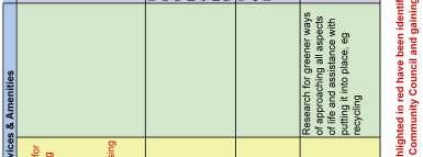
16 2.Village Character Open Spaces There are few areas of open space in the village. A green area adjacent to the local shop and post office is an area which could be developed as an attractive open space area and which is centrally located. The development of this open space area was an issue raised at the public consultation. Other areas of open space are those that form part of the various housing estates. These are substantial areas of open space in their own right and as most of these have only being created in the last 10 years these space will become more attractive as the planting in them matures. The local GAA grounds and playing pitch located outside the village boundary is an important recreational and open space area. Planting Mature natural hedgerows are prominent throughout the village and demarcate boundaries between the built form and the surrounding landscape. There is a substantial amount of mature trees located along the banks of the local river, around Nurney Bridge and a line of poplars across from the local church. More recent tree planting has occurred in the incidental areas of open space located throughout the village and as a part of the various housing estates. The opportunity exists to further encourage tree planting within the village. All approaches to the village are well planted with mature trees and hedgerows and these should be retained and supplemented where possible. is not occurring. Water supply and surface water are not seen as serious issues fro the village. Figure 17: Recycling facilities. Nurney has a rich natural landscape which adds to the character of the village. Existing views and vistas, natural boundary features, existing natural hedgerows, the local river, open space areas and mature tree planting on approaching the village need to be respected and considered in line with any future development in the village. Section 4 looks at general and specific design guidelines for future proposed developments. In this section measures are outlined as to how new developments can respect the existing landscape character and setting of the village. Village Character Figure 16: Mature trees across from the primary school. Environment There are recycling facilities in Nurney which are located beside the new cemetery. These recycling bins have being vandalised and a lot of illegal dumping has occurred around them in the past. The issue regarding the location of these recycling bins was raised at the public consultation. Kildare County Council is open to negotiation regarding the re-location of these facilities ensuring that certain standards are met. The current wastewater treatment plant has a capacity for 500pe. This is a relatively new facility and is not seen as an issue for the village. There was some concern raised regarding pollution of the local river in the past. Regular testing by the appropriate authorities is needed to ensure that pollution Page 16
17 2.Village Character Insert Landscape Character Map Village Character Page 17
18 Section 3: Public Consultation 3(і) Key Issues A public meeting was held on Thursday the 17 h April 2008 in the local national school in Nurney. At this meeting members of the local community voiced their opinions on what they felt were the critical issues concerning the future development of the village. The following points are a summary of the issues raised: Local Services New school needed as current school is at capacity. Planning application for new school has been granted permission, waiting on go ahead from the Dept of Education Waste water treatment plant is at capacity Recycling bins possibility of relocating them to a new more supervised location they are currently being vandalised, burnt and dumping is occurring around the bottle banks Undergrounding of all cables and overhead wires in the village Extension of sewerage system to serve older houses which have their own septic tanks Poor surface of roadway up to Church View, roads need to be upgraded and re surfaced Traffic Management & Parking Speed ramps and speed limit signs needed from Walterstown Cottages to the village Lack of car parking at school, very dangerous at drop off and collection times as road is blocked and cars are parked everywhere Realignment of bend approaching village form Kildare side to prevent further accidents from occurring Removal of bend on approach road from Monasterevin as it is dangerous and is the cause of a number of crashes Approach road from Kildare is in poor condition and needs to be resurfaced Pedestrian Safety Pedestrian footbridge needed at the Bridge crossing. At present there is no footpath crossing the bridge and it is dangerous for pedestrians Linking the housing estates with the shop new footpaths need to link outwards from the village centre and should be wide enough for buggies, have dished curbs where necessary and need to link up with existing footpaths Path from Walterstown Cottages into the village Level footpath from Nurney village to the local GAA pitch New Development 10 acres of land owned by Council located to the rear of the national school should be developed for mixed use community/parish hall, private and affordable housing, playground etc New developments should be small in scale to protect the existing village core and to retain the existing character of the village New developments should not contain any apartments as they are not in keeping with the original built fabric of the village Landscaping & Public Realm Street lighting throughout the village, need for more lighting in a consistent style. Style to be agreed by the local community Area opposite pub possibility for amenity area/ playground Archaeological investigation of area opposite pub Wall improvements around old and new graveyards Define approaches to the village general landscaping and signage to identify entrances to the village Litter bins needed as part of streetscape improvement in a style to be agreed upon by the local community Landscape green area at Nunnery Need for more landscaped areas, more significant in landmark locations throughout the village. More tree planting to tie in old village core with new developments Need for seating areas in the village 3. Public Consultations Public Consultation Figure 18: Extension of footpaths outwards from village core. Figure 19: Littering around recycling facilities. Page 18
19 3. Public Consultations Lack of Community Facilities Need for facilities for young people Ball alley site suggestion of parish hall or area to be restored and put to good use. Antisocial behaviour occurring in the site at present Playground and public hall required for the village Walking route along the local river to be developed New interpretative board for the village with local information and historical/ heritage information Retain Character of the Village Restoration of bridge not to be removed Restoration of stone walls along main roads in village Any small developments to be in character and scale of village visual amenity to be retained Delivery of New School New Developments Lack of Public Open Space Other Issues Pollution of the local river (Kildare Town Treatment Works) Water flow in the river Figure 20: Pollution of local river. Local Services KEY ISSUES Linking of Footpaths Lack of Community Facilities Pedestrian Safety Public Consultation Upgrading & Re Surfacing of Local Roads Key Local Issues Page 19
20 3. Public Consultations Public Consultation Page 20


21 3. Public Consultations The kids were asked to draw what they liked about their village: Public Consultation Page 21
22 Section 4: Design Guidelines 4 (і) General Design Guidelines The following Design Guidelines have been developed following a comprehensive analysis of the qualities and character of Nurney that contribute to its distinctive identity. These characteristics have been identified by the local community as being fundamental to the development of design guidelines that will shape the future of the village in terms of new works, facilities, services and amenities. These design guidelines are intended to retain what is special about the character of the place and to improve and enhance this special character. These Design Guidelines have the following three strategic objectives: 1. To conserve and enhance the character of Nurney and its important features and landmarks; 2. To set out criteria-based standards against which changes to Nurney may be judged, to ensure that new development contributes positively to the village. 3. To make recommendations for new works, with the aim of improving the urban realm, to be carried out in partnership with the local community. In the preparation of these guidelines reference has been made to The Urban Design Manual: A best practice guide (a companion document produced by the DoEH&LG, to accompany the Draft Planning Guidelines on Sustainable Residential Development in Urban Areas). The manual states that the most successful and sustainable communities are the ones that contain a good variety of things to do, see and enjoy. For larger scale developments, this means providing a good mix of uses, housing, facilities and amenities that help to engender a successful community; and thought should be given to how commercial uses are placed in relation to each other to help create a vibrant neighbourhood centre. In relation to layout the document states that a layout creates people friendly streets and spaces if: Layout aligns routes with desire lines to create a permeable interconnected series of routes that are easy and logical to navigate around. The layout focuses activity on the streets by creating active frontages with front doors directly serving the street. The streets are designed as places instead of roads for cars, helping to create a hierarchy of space with less busy routes having surfaces shared by pedestrians, cyclists and drivers. Traffic speeds are controlled by design and layout rather than by speed bumps. Block layout places some public spaces in front of building lines as squares or greens, and some semi private space to the back as communal courts. More details on the implementation of this Village Design Statement are set out in part (ii) of section 4 below. These Design Guidelines consider the village under a number of Key Strategic areas, and should be read in tandem with the Key Strategies Map within this document. Below there is also a series of Design Guidelines for new residential and mixeduse developments within Nurney (as identified on the Key Strategies Map page 30). The Key Strategic Areas are as follows: Key Strategic Areas 1. Village Structure Vill 2. Village Streetscape Street 3. Landscape Setting and Open Space Land 4. Design of New Development Desi 5. Benefiting the Local Community Comm Policy Objectives Commence with 4.Design Guidelines Design Guidelines Village Structure The Kildare County Development Plan has identified settlements and grouped them into four categories: 1. Consolidation 2. Strengthening 3. Revitalisation 4. Rural Nodes Page 22
23 4.Design Guidelines These settlements have been categorised based on the following criteria: (i) Size of the settlement; (ii) Existing community; (iii) Infrastructural facilities, and; (iv) Development that has taken place to date. Having taken these factors into account, Nurney is identified as being a village with strengthening properties. This means that the Development Plan recognises that the village has experienced some growth in recent years. However, it is considered that Nurney has the capacity to accommodate limited growth, having regard to the availability of adequate social infrastructure. Policy RS2 states, in relation to Nurney and other strengthening settlements that: Similarly, in this context, the local need category has not benefited from the development that has occurred in these communities. As such, whilst there is an intention to accommodate both local need and local growth categories, there is equal emphasis on the provision of housing for local need and local growth. Figure 21: Historic development in the village. Vill 01 Incorporating New Development Vill 02 Historic Core Vill 03 Village Form Figure 22: Modern development in the village. Nurney has a historic village core, centred on the River, Bridge and historic Nunnery, Castle and Church complex to which the village owes its origins. New development is principally located southwards of this historic core, which has led to some lack of connectivity and lack of access to local services within the village. Given Nurney s capacity to accommodate new development within the village development boundary, new proposals shall provide a wide range of house types to cater for a range of household types in the village. In addition, new development shall prioritise, within its location, layout and configuration, the promotion of good walking routes through the village and to access local services. (See separate Design Guidelines for New Development below). The historic village core retains significant archaeological interest and shall be largely retained in its current form, in particular given the presence of Nurney River and its potential for flooding. The historic core of Nurney is centred on the crossroads and Nurney Bridge and shall be retained, as outlined on the Key Strategies Map. Any new development proposals within the historic core shall be small in scale and of an appropriate character to the place and the vernacular style of architecture. The present-day expansion of the village will occur southwards of the village core, resulting in a dumbbell shaped village form, as identified on the Key Strategies Map. This should both conserve the historic origins of the village and meet the needs of the future village community. Design Guidelines Vill 03 Pedestrian Links to Village Services Pedestrian pathways will be improved and established in Nurney in order to improve local connections and safety for walkers. Proposed pedestrian routes, and footpath improvements, are identified on the Key Strategies Map. In particular, these routes are intended to provide good access to local amenities and facilities. These routes should be sign posted to act as amenity routes/ healthy ways for leisure walkers, and lighting and seating put in place at appropriate locations. New village amenities, services and facilities should be located so as to facilitate ease of pedestrian access and allow for multi-purpose trips, to avoid local-trip making by car. Page 23
24 4.Design Guidelines Village Streetscape The village core is located at a river crossing point and is therefore located in the river valley and uphill from that (northwards from Nurney Bridge). As such, the village centre and the former Nunnery site and housing to the north are located on an elevated position. This Village Design Statement proposes a Dumbbell shaped village form, in order to achieve the following objectives: 1. Retain the historic core; 2. Retain a corridor of green space along the Nurney River; 3. Accommodate residential, amenity, services and facilities for the local community into the future. In terms of streetscape, this new village form offers potential to create new walking linkages within the village, and therefore new streetscapes. Residential layouts should be based on the following core principles: Place: understanding and blending with the landscape. Hierarchy: relationship of buildings to each other and the relative significance of their different elements. Scale: relating to human proportions and the scale of the buildings in an area. Harmony: blending buildings with the local and natural environment. Enclosure: defined boundaries to development and define areas such as squares and courtyards. Decoration: careful craftsmanship enhancing every aspect of every building. Signs and Lights: well-designed street signs, advertising in its place, and careful use of artificial light. Community: a sense of pride and a feeling that everyone contributes to the planning and organization of the place. Street 01 Existing Streetscape Street 02 Streetscape of New Development Infill Development Layouts Street 03 Trees & Green Spaces Street 04 Footpaths & Cycleways Street 05 New Development Layout In terms of the existing streetscape, the village streetscape shall be reinforced along the main road, when the opportunity arises in the context of new development. There is potential to provide a strong gateway entering the village from the south by creating a new streetscape on the lands located south of the Primary School. New Development Areas in Nurney offer significant potential to create new streetscapes that contribute towards an improved urban form in the village. Buildings shall have minimal setbacks to create a strong building line, with grouped, clustered and terraced housing being the favoured residential form. Streets should be curving with permeability favoured over cul-de-sac type layouts. Clustered layouts create passive surveillance and an intimate village type streetscape, based on irregular plot sizes, some of which may be smaller in order to vary the development pattern. Shared surfaces, small front gardens, grouped parking layouts and the incorporation of landscaping as fundamental to the layout design process will contribute towards the design ethos of these places. Where possible, street trees and ancillary green spaces are to be retained and new ones introduced to improve the visual amenity of the streetscape. These should be carefully selected indigenous or other appropriate species planted appropriately and to a scale that reflects the rural character of the village, which has been described in Section 2 of this report. Traffic management measures and new and improved walking and cycling routes (to increase public safety) should be a priority for implementation. This includes the introduction of footpaths and crossing points (preferably on the same level as the footpath) and the resurfacing of local roads. These are identified on the Key Strategies Map p30. In general, new developments shall be laid out and the residential units designed and orientated so as to encourage active frontage and lively streetscapes. This may include the use of the gable form, the introduction of porches and entrance doors located on the front elevations (rather than the side). Boundary treatment shall be low in scale and height, thus encouraging passive surveillance. Design Guidelines Page 24
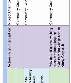
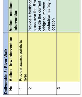
25 4.Design Guidelines Landscape Setting and Open Space The landscape setting of the village is defined by the presence of the river valley in the centre and the consequent fall in the level of the land. The landform rises towards the north of Nurney, with the landscape comprising large fields in agricultural use. There is currently a severe shortage of quality amenity open space for the local community and a lack of any facilities for play areas, including formal playing pitches, tennis/ basketball courts, playgrounds etc. Land 01 Open Space Land 02 Hedgerows Land 03 Viewpoints Land 04 River Walk Existing ancillary areas of open space are to be retained to serve established residential developments. New developments are to provide quality areas of open space with facilities such as play grounds, sports facilities and other facilities in accordance with community needs. In this regard, please refer to the list of community requirements within Section 4 (iii) of this document (Delivery & Implementation). Existing hedgerows and significant viewpoints have been identified on the Landscape Character Map. Where possible, these hedgerows shall be retained within areas of open space, thus providing an opportunity to create linkages between housing estates and a means of promoting permeability. It may be appropriate to retain hedgerows as wildlife refuges in areas of open space providing that they do not act as a barrier or cause security/ safety/ passive surveillance problems. The topography of Nurney contributes significantly to its character and visual amenity. In particular, the river valley and adjacent rising landforms to the north of the village core provide interest and variety to the village. High points have been identified on the Landscape Character Map. Panoramic views shall be retained from the Pigeon House hill site, and new development south of the river shall respect this viewpoint. Furthermore, views and visual corridors shall be retained towards the river within new development proposals. Planning applications shall demonstrate that they have no negative impact on the views and visual amenity of this area. A River Walk is proposed along Nurney River from the village to the GAA grounds (See number 3 on Key Strategies Map). This river is to be maintained as a natural and amenity feature and is to be kept open (i.e. not culverted) in the context of any new development proposals within the village. In particular, the bridge and part of the river at the village core shall be an amenity feature and/or focal point for village improvements. Design Guidelines Figure 23: Street treatment, Poundbury UK. Figure 24: Existing hedgerows to be retained where possible. Page 25


26 4.Design Guidelines Design Guidelines for New Development Areas New Development Areas have been indicated on the Key Strategies Map within this Village Design Statement. A supporting statement must accompany all planning applications for new residential and mixed-use developments in these areas indicating how the development meets the guidelines and criteria set down below. In addition, all development proposals will require a social needs assessment as set down in Section 4 (iii) below. In general, this supporting statement shall demonstrate how the developer will deliver a quality residential environment on a particular site. Planning permission will only be granted for new residential development where it is demonstrated that the proposal will create a quality and sustainable residential environment. Quality design proposals should emerge from a careful analysis of the site s location, surrounding context and the specific characteristics of the site itself. The statement should outline in writing the overall design concept and objectives for the site, based on the appraisal of the site and its context. Any proposal for residential development which fails to produce an appropriate quality of design and which fails to conform to these and other relevant criteria will not be permitted. While this VDS has not identified particular sites for infill development within Nurney, we would note that Section 5.10 of the Kildare County Development Plan states the following in regard to infill housing: Infill housing in existing built up areas of the towns and villages of the county will be encouraged. Any proposals should be designed to integrate successfully with the existing pattern of development in terms of housing type, scale and details such as materials, finishes, building lines etc. In all cases the protection of the amenities of existing development should be a significant consideration. Furthermore, please refer to Chapter 6 Rural Housing Policy of the Kildare County Development Plan for further policy objectives that are of relevance to new residential development within Nurney. Design Guidelines Figure 25: Example of residential design, Poundbury UK. Figure 26: Layout to control traffic speed (Urban Design Manual 08). Page 26
27 4.Design Guidelines Desi 01 General New Development Design Standards Desi 02 Housing Layouts & Permeability Desi 03 Building Heights Desi 04 Proposals for Future Residential Development Sites The design of new development shall draw upon the best local traditions of form, materials and detailing, which would include the use of stone, simple house forms, pitched roofs and a mix of wide frontage and gable fronted houses. In this regard, all planning applications shall be accompanied by a supporting statement that outlines how the design approach has been achieved. Generally, providing a mix of narrow and wide frontage houses will be encouraged, in order to vary plot size and create a varied plan form. In developing housing layouts, permeability shall be a major consideration, most particularly for pedestrians and cyclists. Layouts based on cul-de-sacs will not be permitted as these increase travel time, reduce accessibility to local services and amenities and do not promote walkability of places. In all residential developments, the safety of pedestrians and quality of life should be given priority over vehicular traffic. The layout and design of all developments shall be configured so as to deter crime and promote personal safety. The use of varied building heights is a useful device in creating urban enclosure and in forging a strong sense of place. Generally, in Nurney, between 1- and 2.5-storey buildings are considered preferable. New Development Areas have been indicated on the Key Strategies Map p30, which are of a size and scale to establish their own character, while working within the parameters of this VDS. Proposals for these sites must demonstrate the following: Provision of pedestrian linkages to key services and amenities; Design incorporating a strong road frontage that complements the existing streetscape; Clustered/ grouped housing layouts within the site that maximises the efficient use of land and provides for a permeable layout; Including a range of house types and sizes, to cater for local needs, affordable housing and general new development in accordance with the village s strengthening status in the County Settlement Strategy. Apartment and duplex type units will not normally be considered acceptable; Provision of open space that is of a scale, location and configuration that maximises usage by all members of the local community with all levels of mobility, including a children s playground/ play area; Provision of amenities/ local facilities or an alternative planning gain that will benefit the entire local community; Shared surfaces to be provided in lieu of distributor-standard roads, subject to road safety considerations being met. Design Guidelines Figure 27: Layout design and open space (Urban Design Manual 08). Page 27
28 4.Design Guidelines Desi 05 Open Space & Hedgerows Desi 06 Parking Desi 07 Infrastructure Desi 08 Materials Desi 09 Gated developments Desi 10 Orientation of layouts Desi 11 Waste storage Within new development areas, adequate provision shall be made for public and private open space and landscaped areas (in accordance with Kildare County Development Plan standards). However, these areas shall be provided as an integral part of the development. Where appropriate, planted areas or discrete groups of trees will be required along site boundaries in order to soften the visual impact of the development and assist in its integration with the surrounding area. Hedgerows may be used as an open space feature (see policy Land 02 and Landscape Character Map). Open space and amenity areas shall be configured so as to provide both ancillary green areas and a single larger area of open space to provide for the amenity needs to residents. Where possible and practical, residential units shall be located facing areas of open space. Adequate and appropriate provision shall be made for parking which, in principle, should be operationally and physically unobtrusive. In new residential developments, parking shall be provided within the curtilage and in accordance with Kildare County Development Plan standards. It shall be demonstrated within all planning applications that the infrastructure has the capacity to absorb the demands of the proposed development (both existing and new/ upgraded infrastructure). In particular, new development proposals must demonstrate that there is sufficient capacity in the Kildare town treatment Works to treat the sewerage or provide alternative proposals to adequately treat the effluent generated. In terms of materials, given the variety of materials within Nurney, a range of new materials will be acceptable, subject to agreement with the planning authority. Within any single development there should be a limited palette of materials to avoid visual clutter. The development of residential gated communities will not be permitted by Kildare County Council in Nurney. Good natural light makes dwellings more attractive, pleasant and energy efficient. Housing layouts shall be designed, oriented and sited so as to maximise daylight and sunlight (solar gain) to dwellings as far as possible, thus being sustainable by design. This is to be achieved while maintaining high standards of design in general, particularly in relation to privacy, existing residential amenity and the achievement of an attractive streetscape. New housing estates and layouts will allow for the inclusion of waste storage and collection facilities deemed appropriate for households and estates. Design Guidelines Page 28
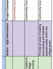
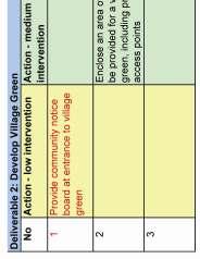
29 4.Design Guidelines Benefiting the Local Community The process of preparing this Village Design Statement is one that has been fundamentally based on community participation, without which this document would not have been prepared. A community consultation workshop with the local community has led to the formulation of the objectives and strategies within this VDS. The majority of the aims and objectives have been conceived so as to benefit the local community in the shorter, medium and longer term. Comm 01 Comm 02 Comm 03 Encouraging and supporting the development of new community facilities will be a priority for the local community and for Kildare County Council. These may include a community/ sports hall, sports fields/ playing courts, amenities for children and teenagers, services for the elderly and improved services for the national school. The future use of the Handball Alley was raised in community consultation as a matter of importance. The Alley has become a focal point for anti-social behaviour and is an unsupervised space as it is not overlooked and has tall walls on all sides. The alley has been recorded by the National Inventory of Architectural heritage as having a Regional rating, arising from which a Ministerial Recommendation would normally issue for the structure to be incorporated on the county RPS. While the structure is a good example of its type, it currently is a landmark building in an important location in the village that does not appear to serve a useful function in community life. This VDS proposes that the Community Council addresses the future of the Handball Alley as a community project. There are a number of options in this regard: (i) Retain the structure as present the structure could be floodlit and used for 5-a-side football, archery and other activities; (ii) Roof the structure the structure could be covered with a light weight and inexpensive material that would render is weatherproof and again be used for youth and sporting activities. (iii) The structure could be used as a Youth Shelter, with one of the walls being rendered for use as a focal point for creative activities in the form of a graffiti wall. In the case that the handball alley is a Protected Structure all of the above proposals would be subject to planning permission. This matter is to be raised at the next community consultation for discussion. The local community are to be assisted and supported in providing and improving green and amenity spaces in Nurney, in particular the River Walk ( No. 3 on the Key Strategies Map) and the Village Green (No. 5 on the Key Strategies Map) for the use of the whole community of Nurney. Design Guidelines Figure 28: Development of river walk. Figure 29: Future use for the handball alley. Page 29
30 4.Design Guidelines INSERT KEY STRATEGIES MAP Design Guidelines Page 30

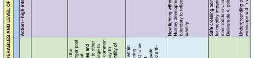
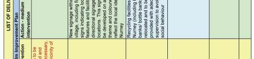
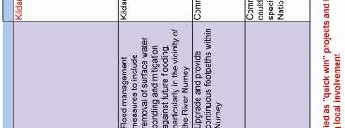
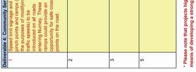
31 4.Design Guidelines 4 (іі) Specific Design Guidelines DESIGN GUIDELINES: LEGEND FOR MAP 1. Areas for New Residential Development have been indicated on the Key Strategies Map, which are of a size and scale to establish their own character, while working within the parameters of this VDS. Proposals for these sites must demonstrate the following: Provision of pedestrian linkages to key services and amenities; Design incorporating road frontages, where site boundaries allow, on the main road accessing Nurney that enliven and create interest along the streetscape, including the possible use of sentinel / gateway buildings at the entrances to these developments that serve the function of a gatelodge-type dwelling signalling the presence of the development on the streetscape; Clustered/ grouped housing within the site that maximises the efficient use of land and provides for a permeable layout; Layouts to include a range of house types and sizes; Provision of open space that is of a scale, location and configuration that maximises usage by all members of the local community with all levels of mobility, including a children s playground/ play area; Provision of amenities/ local facilities or an alternative planning gain that will benefit the entire local community. 1A. Please note that developments on these lands will be subject meeting Kildare County Council s and government policy and objectives in terms of flood management and mitigation. the local GAA club located to the north of the village. 4. The lands in the ownership of Kildare County Council to the west (rear) of the Primary School are to be utilised for expansion of the school site and extension of school facilities and for a residential or mixed-use development to include affordable housing and local amenities/ services, in particular the incorporation of a village/ community hall. 5. A Village Green is to provide a new amenity area of open space on these lands in the form of a wildflower garden with a playground and seating area. Appropriate play equipment is to be utilised, ensuring that the archaeological remains on the site are not damaged on-site monitoring by a qualified archaeologist may be necessary in the case of earth moving or digging being required. This site is also to be the location of a community notice board (see number 8 below). 6. Traffic calming measures are to be introduced on the entrance routes to Nurney, as identified on the Key Strategies Map, comprising reduced speed limit signage, pinch point and raised area for prams and wheelchair users to cross the road in safety and with maximum ease. 7. Footpaths are to be upgraded and new connecting section introduced to ensure continuous walking routes on a separate walkway throughout the village of Nurney. 8. Information signage is to be placed in the village, to include a village notice/ information board erected at, or in the vicinity of, the Village Green, providing information for both the local community and visitors alike. Design Guidelines 2. An Urban Realm Improvement plan is to be prepared for Nurney by the Community Council in partnership with the Local Authority, to include new lighting, signage, litter bins, seating and areas identified for improved footpath and walking routes. A particular focus for this plan is the bridging point on the Nurney River and the river village core and crossroads, and making a feature of the river in the centre of the village. In addition, proposals are to be prepared for the undergrounding of the wirescape along the main road within the village boundary. 3. The establishment of a River Walk is to be investigated by the Community Council in partnership with Kildare County Council in order to create an amenity space and to provide a safe walking route to access Figure 30: Example of heritage signage. Page 31


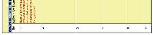
32 9. Kildare County Council is to investigate the possibility of realigning the road entering the village from Monasterevin in order to improve road safety and sightlines by removing the bend in the road line. 10. Natural stone walls along the main road through Nurney are a feature of the village, and shall be retained, maintained and reinstated, in particular those at the church and graveyard. 11. Waste Water Treatment: sufficient capacity must be provided at Kildare town treatment works to accommodate new development to ensure that discharges to local rivers are in accordance with best practice standards. 12. The recycling bins are to be relocated to the car park opposite the Church and adequate lighting is to be placed in their vicinity in order to deter anti-social behaviour and vandalism. 13. Handball Alley: options for future usage of alley, as set down in strategy Comm 02. Figure 31: Seating as part of urban realm improvements for the village. Figure 32: Amenity area for the village. Page 32
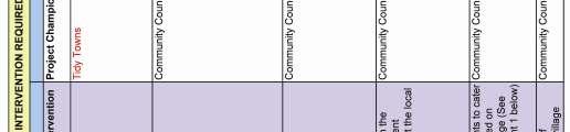
33 Delivery 4(ііі) Delivery - Action & Implementation Programme This VDS sets out aims and objectives for the management of development that will act as a positive tool for change to benefit the community of Nurney. This VDS has outlined the analyses and the proposals, as put forward by the local community, to be achieved in the short, medium and longer term. This particular section of this VDS sets out a framework for the achievement of the plan s objectives. The delivery of the plan involves cooperation from the local community, developers and local authorities in order to promote the protection, conservation, appropriate uses and future management of the village. The implementation of this plan will require investment in both physical and social infrastructure to support the protection and conservation of the area and the other developments within Nurney. The Local Authority will expect and require that developers fund and provide the infrastructure necessary to support any development proposed by them and to contribute financially to the cost of other essential infrastructure and amenities necessary to support the development of the town as a whole. This will be achieved through the measures outlines below. All significant development proposals will require a social needs assessment as part of the planning application to ensure that the following list is provided for in the village: 1. Playground 2. Open Space & Amenity Areas 3. Primary School 4. Community Hall 5. Adequate wastewater treatment facilities 6. Improvements & extension of footpaths 7. Crèche or playschool facilities 8. Upgrade surface water drainage 9. Upgrading of local road surfaces 10. Street Lighting Establishment of Community Council In order for the objectives of this VDS to be delivered, it is proposed that a Community Council be established as a limited company with charitable status. This Community Council will effectively be the project champion for this VDS. Its role will be the following: 1. Establish a committee of members elected by the local community annually for the purpose of achieving the objectives set down in this VDS. 2. Secure funding for projects proposed within this VDS, and others projects in the future. This VDS may be used in support of funding applications - potential sources of funding are listed in Appendix 1 below. 3. Act as a community liaison and contact point for Kildare County Council and other statutory bodies and agencies in future proposals and managing change for the village of Nurney. 4. Update the objectives of the VDS and develop new objectives, as appropriate. (See the Performance Report below) 5. Keep the local community updated by various means, including holding meetings, a community website and notice board and using any other local forum, for example a local newsletter or newspaper. (See the Communications Strategy below) Communications Strategy & Performance Report The delivery of this planning strategy will rely on all the relevant information being provided to the delivering organisations. The adoption of a Communications Strategy will clearly set down matters such as the protocols and regularity of meetings and communications to partners and the wider local community. It may be considered useful to establish a community notice board, website, circulars, and other means of communicating regular updates. Delivery It is also suggested that an annual Performance Report on the plan s progress. This will ensure that progress is monitored and evaluated and that, where necessary, priorities are reassigned or new projects/ actions are identified. For a detailed explanation of local need and local growth, please refer to Chapter 6 of the Kildare County Development Plan. Infrastructure works may include roads, cycleways and footways, water, sewerage and land drainage, and other services such as electricity, gas or telecommunications. The specific requirements for each site will depend on local circumstances. Page 33
34 Delivery Funding and Timeframe There are many varied sources of funding available in order to achieve the objectives set down in this VDS. Some examples of funding sources are listed in the Appendix 1 of this document. In order to deliver this VDS in an effective, timely and coordinated manner, a series of priorities must be set down. The Action Plan table below sets out the following: i. Action ii. Level of Intervention iii. Timescale iv. Project Lead/ Champion v. Possible Source of Funding Quick win projects have been identified in the table. These have one or more of the following criteria: Delivery I. Deliverable in the short term; II. Have the potential to have a positive spin-off or calalytic effect; III. May not require a significant level of funding; IV. May not be impacted by regulatory or other constraints; V. Are readily achievable within the current structure/ available funding. It is vital that this Action Plan be regularly augmented and amended so that priorities are updated as necessary and that any new projects are identified on an ongoing basis. Page 34

35 Delivery Delivery Page 35

36 Delivery Delivery Page 36

37 Delivery Delivery Page 37
20. Ballysadare Mini-Plan
 20. Ballysadare Mini-Plan 20. Ballysadare Mini-Plan Community facilities Ballysadare has a wide range of community facilities: a primary school, St Mary s College (secondary school), a health centre, playing
30. Riverstown Mini-Plan
 County Development Plan 2017-2023 Consolidated Draft + Adopted Amendments August 2017 Volume 2, Chapter 30 Riverstown Mini-Plan 30. Riverstown Mini-Plan Village profile Riverstown is located approximately
28. Coolaney-Rockfield Mini-Plan
 28. Coolaney-Rockfield Mini-Plan 28. Coolaney-Rockfield Mini-Plan Community facilities Community facilities in Coolaney-Rockfield consist of a primary school, crèche, community centre, sports field and
Urban Design Guidelines
 Urban Design Guidelines These Urban Design Guidelines comprise the Key Design Objectives below, the Roads Design Guidelines overleaf and Neighbourhood Framework Plans. Together with Section 3: Urban Design
17. Coolaney-Rockfield Mini-Plan
 County Development Plan 2017-2023 Consolidated Draft + Adopted Amendments - August 2017 17. Coolaney-Rockfield Mini-Plan Village profile Coolaney is located approximately 23 km to the south-west of Sligo
CLOUGHJORDAN SETTLEMENT PLAN
 CLOUGHJORDAN SETTLEMENT PLAN 1.0 General Introduction and Development Context Location The market town of Cloughjordan lies close to the border with Offaly at the junction of the R490 and R491 Regional
Lancaster Conservation Area Appraisal. Character Area 8. Cathedral
 Lancaster Conservation Area Appraisal Character Area 8. Cathedral March 2013 118 3.8 Character Area 8. Cathedral 3.8.1. Definition of Special Interest "This character area is distinctive for the fine group
6. Ballintogher Mini-Plan
 County Development Plan 2017-2023 Consolidated Draft + Adopted Amendments August 2017 Volume 2, Chapter 6 Ballintogher Mini-Plan 6. Ballintogher Mini-Plan Village profile Ballintogher is located approximately
Schedule of Planning Applications Committee Date: 23 May Reference: 06/17/0726/F Parish: Hemsby Officer: Mr J Beck Expiry Date:
 Schedule of Planning Applications Committee Date: 23 May 2018 Reference: 06/17/0726/F Parish: Hemsby Officer: Mr J Beck Expiry Date: 22-05-2018 Applicant: Proposal: Site: Mr Gillett Change of use to the
8.0 Design and Form of Development 43/
 42/ 8.0 Design and Form of Development 43/ Rothwells Farm, Golborne/ Development Statement Figure 7. Site Constraints Key 44/ Site Boundary 360 Bus Route/Stops Existing Trees Underground Water Pipe Sensitive
Welcome to our public exhibition
 About our scheme Welcome to our public exhibition Taylor Wimpey East Anglia intends to submit a detailed planning application for a new residential development of 39 high-quality homes at the B&M Concrete
Public Consultation. Land at Monks Farm, North Grove. Welcome
 Welcome Welcome to our public exhibition for development on Land at Monks Farm, orth Grove. Gallagher Estates and Gleeson Strategic Land are preparing an outline planning application for new homes, open
Woodbrook - Shanganagh
 Section 4: Key Sites Framework Strategy Woodbrook - Shanganagh Local Area Plan 2017-2023 4. Site Framework Strategies The Master Plans shall have regard to the thematic objectives under the LAP Development
Colchester Northern Gateway Master Plan Vision Review Draft. July 2016
 Colchester Northern Gateway Master Plan Vision Review Draft July 2016 Contents Introduction 4 Context 8 Purpose of the Report 8 Strategic Position 9 Overview of the Process 11 2012 Master Plan Vision 12
Chapter 2: OUTLINE PLANNING APPLICATION PROPOSALS. A New Garden Neighbourhood Matford Barton 17
 Chapter 2: OUTLINE PLANNING APPLICATION PROPOSALS A New Garden Neighbourhood Matford Barton 17 2.1. SUMMARY AND STATUS OF THE PROPOSALS 2.1.1. The parameter plans and associated wording in this chapter
WHITELEY TOWN COUNCIL NORTH WHITELEY DEVELOPMENT SEPTEMBER 2014
 WHITELEY TOWN COUNCIL NORTH WHITELEY DEVELOPMENT SEPTEMBER 2014 Dear Resident This Special Edition of the Whiteley Voice which has been prepared in conjunction with the North Whiteley Consortium is to
Welcome to our public exhibition
 About our development Welcome to our public exhibition This exhibition gives you the chance to view and comment on our proposals for a new residential development of 165 high-quality homes, along with
Chapter 5 Urban Design and Public Realm
 5.1 Introduction Public realm is all areas of the urban fabric to which the public have access. It is where physical interaction takes place between people. It therefore, includes buildings and their design,
6 Site Framework Strategies
 6 Site Framework Strategies 6.1 Introduction Section 6 identifies a number of specific areas which are considered to be key sites within the Plan area and which may have potential for development / redevelopment.
Rathmolyon Written Statement
 Settlement Rathmolyon Position in Settlement Hierarchy Village - Local centre for services and local enterprise development Position in Retail Strategy Fourth tier retail centre Population (2011) Census
PUBLIC RIGHT-OF-WAY IN THIS CHAPTER PUBLIC REALM
 PUBLIC RIGHT-OF-WAY This section provides design guidelines for improvements in the public right-of-way. The public right-of-way refers to streets, sidewalks, non-vehicular thoroughfares, parks and greenways
BORRISOKANE SETTLEMENT PLAN
 BORRISOKANE SETTLEMENT PLAN 1.0 General Introduction and Development Context Location Borrisokane is located 15km north of Nenagh on the N52. While the town is primarily residential, it acts as a market
WELCOME GYPSY LANE. Wider Site Location plan. Proposals for the development of LAND OFF FOXLYDIATE LANE WEBHEATH. Proposals for the development of
 WELCOME The developers are preparing an outline planning application for a residential led development and need the community s views in order to develop the proposals further WHAT IS PROPOSED? A high
Statement of Community Involvement LAND OFF SOUTHDOWN ROAD HORNDEAN, HAMPSHIRE
 LAND OFF SOUTHDOWN ROAD HORNDEAN, HAMPSHIRE CONTENTS Page 1. Introduction 3 2. Pre-application Discussions 4 3. The Consultation Process 5 4. Consultation Feedback 7 5. Responses to Consultation Feedback
Neighbourhood Plan Representation
 Date: 10 th November 2017 Neighbourhood Plan Representation Land to the east of Callow Hill Road, Alvechurch Introduction This representation has been prepared by RPS Planning and Development on behalf
Newcourt Masterplan. November Exeter Local Development Framework
 Newcourt Masterplan November 2010 Exeter Local Development Framework Background The Exeter Core Strategy Proposed Submission sets out the vision, objectives and strategy for the development of Exeter up
Character Area 1: Town Core
 Character Area 1: Town Core Map S 354 Copyright Cotswold District Council 109 Character Area 1: Town Core Key Characteristics 355 356 357 358 359 360 361 362 363 364 365 366 367 368 369 370 Copyright Cotswold
LONGDEN VILLAGE DEVELOPMENT STATEMENT
 LONGDEN VILLAGE DEVELOPMENT STATEMENT 2017-2027 1 Longden Development Statement 2017-2027 15/01/18 1. Background 1.1 Longden Village Longden village is a very rural and traditional community first mentioned
CAERNARFON DEPENDENCY CATCHMENT AREA
 CAERNARFON DEPENDENCY CATCHMENT AREA GWYNEDD UNITARY DEVELOPMENT PLAN - HOUSING Map not to scale Dependency Catchment Area Location 2 Caernarfon Topic Housing To the rear of Bro Eglwys, Bethel. Grid Ref.
Kibworth Harcourt. Introduction. Introduction
 Introduction Introduction Welcome to this public exhibition on the proposals for the delivery of new homes on land at The Kibworths. The purpose of today s exhibition is to give you the opportunity to
Welcome. Land adjacent Sandy Lane WALTHAM CHASE THE PROPOSED SITE
 Land adjacent Sandy Lane WALTHAM CHASE Existing Linden Homes developments Welcome Welcome to Linden Homes Southern s ( Linden ) public exhibition about its proposals for a range of high-quality homes for
3. Neighbourhood Plans and Strategic Environmental Assessment
 1. Introduction This report sets out a draft Screening Determination for the Preston Parish Council s Neighbourhood Plan and has been prepared by rth Hertfordshire District Council. The purpose of the
elbridge Core Strategy
 C elbridge Core Strategy Celbridge is designated as a Moderate Growth Town in the RPGs. The County Development Plan reinforces this designation in its settlement strategy. Moderate Growth Towns within
4.0 URBAN DESIGN FRAMEWORK. The vision for the future development of the plan area is to:
 4.0 The vision for the future development of the plan area is to: Create a new neighbourhood that focuses on the highly valued natural and aesthetic features of the lands and provides good quality homes,
Page 1 of 19 URBAN DESIGN FRAMEWORK FOR BOLTON STREET WATERFORD
 Page 1 of 19 URBAN DESIGN FRAMEWORK FOR BOLTON STREET WATERFORD 1.0 Introduction: The relocation of the City Council stores and depot from Bolton Street creates an exciting opportunity for development
Welcome to our public exhibition
 About Our Scheme Welcome to our public exhibition This exhibition gives you the chance to view and comment upon our emerging proposals for a new residential development of 68 new homes on the site of the
County Development Plan Consolidated Draft + Adopted Amendments August 2017 Volume 2, Chapter 22 Easky Mini-Plan
 22. Easky Mini-Plan Village profile Easky is a coastal settlement located approximately 40 km to the west of Sligo City, in a designated Rural Area In Need of Regeneration. The nearby coastline is designated
Housing Development at Balloonagh Tralee Co Kerry
 Design Statement Housing Development at Balloonagh Tralee Co Kerry Area of site 10,400m2 24 houses-12no 3 bed, 12no 2 bed and 4 single bed apartments total residential area of 2411m2 Open space provided
New-Cast Mixed-use Development Proposal King Street West, Newcastle, Ontario
 URBAN DESIGN BRIEF New-Cast Mixed-use Development Proposal King Street West, Newcastle, Ontario TABLE OF CONTENTS: 1.0 Executive Summary 2.0 Creating Vibrant and Sustainable Urban Places: Excerpts from
Section 4 - Public Realm & Landscape proposals Landscape Masterplan. Section 4 52
 - Public Realm & Landscape proposals Landscape Masterplan 52 Proposed Masterplan - Green Infrastructure Strategy District Park 4.33 Ha to provide Passive and active recreation with a large play area which
WELCOME. Land North of STEVENAGE. We would like to thank you for attending our public exhibition today.
 WELCOME We would like to thank you for attending our public exhibition today. The purpose of this event is to share our proposals and hear your thoughts on our ideas. Members of the project team are on
STATEMENT OF OBJECTION TO THE PROPOSED DEVELOPMENT OF LAND AT CHURCH CLIFF DRIVE FILEY
 STATEMENT OF OBJECTION TO THE PROPOSED DEVELOPMENT OF LAND AT CHURCH CLIFF DRIVE FILEY You will be aware that Scarborough borough council have adopted a new local plan that includes land at Church Cliff
PLANNING COMMITTEE DATE: 07/09/2015 REPORT OF THE SENIOR MANAGER PLANNING AND ENVIRONMENT SERVICE CAERNARFON. Number: 4
 Number: 4 Application Number: C15/0034/37/LL Date Registered: 21/05/2015 Application Type: Full - Planning Community: Llanaelhaearn Ward: Llanaelhaearn Proposal: Location: Summary of the Recommendation:
PUBLIC REALM STRATEGY
 CONSULTATION DRAFT PUBLIC REALM STRATEGY Trenchard Street & Frogmore Street City Design Group Place Directorate Public Realm Strategy Trenchard Street & Frogmore Street Contents 1. Introduction 2. Understanding
Land at Rampton Road. Cottenham
 Land at Rampton Road Cottenham Introduction TEP is preparing an outline planning application for 54 dwellings on 6.9 hectares of land adjacent to Rampton Road, Cottenham on behalf of the owners Cambridgeshire
URBAN DESIGN BRIEF. 2136&2148 Trafalgar Road. Town of Oakville
 URBAN DESIGN BRIEF 2136&2148 Trafalgar Road Town of Oakville Prepared By: METROPOLITAN CONSULTING INC For 2500674 Ontario Inc November 2016 TABLE OF CONTENTS Page No. 1.0 Introduction/Description of Subject
INTRODUCTION. Land south of Bishopswood Lane, Tadley
 0 INTRODUCTION THE SITE Introduction Gladman Developments Ltd. has successfully invested in communities throughout the UK over the past 0 years, developing high quality and sustainable residential, commercial
Design Guidance. Introduction, Approach and Design Principles. Mauritius. November Ministry of Housing and Lands. .. a
 sig evelo r D Mauritius s. Utilities.. Individu a s. er itects.to ls chpers.po e Public. T. h rban D Sc U e me Promot e h ners. A Design Guidance o.h Planne rs n w iticians r l useholde National Development
II. SINGLE FAMILY RESIDENTIAL
 II. SINGLE FAMILY RESIDENTIAL Castle Rock is made up of numerous individually built houses and subdivision tracts that have been developed during the past century. Some of the tracts are diverse in architectural
Sustainability Statement. Whitby Business Park Area Action Plan
 Sustainability Statement Whitby Business Park Area Action Plan November 2014 Contents Page 1. Introduction 1 2. Scoping 3 3. Sustainability Appraisal of Options 6 4. Assessment of Draft Area Action Plan
Subdivision Design Criteria. Penihana North GUIDELINES TO THE RULES
 Created September 2013 Penihana North Subdivision Design Criteria GUIDELINES TO THE RULES This part of the Plan sets out the design criteria for subdivision in Penihana North. The criteria will be considered
1. Welcome. Background
 1. Welcome The purpose of this exhibition is to provide you with an update on progress on the Kilnwood Vale Scheme. In order to improve the scheme and deliver key facilities earlier in the development,
Introduction. Welcome to this consultation regarding the draft redevelopment proposals for the former CeramTec factory on Sidmouth Road, Colyton.
 Introduction Welcome to this consultation regarding the draft redevelopment proposals for the former CeramTec factory on Sidmouth Road, Colyton. We are currently considering options for the mixed-use redevelopment
Neighbourhood Planning Local Green Spaces
 Neighbourhood Planning Local Green Spaces Introduction... 2 1. Why green space is important... 4 2. Neighbourhood plans and green space... 6 3. Evidence... 8 Statutory designations... 9 Green space audit...
CENTRAL BEDFORDSHIRE COMMITTED TO WORKING TOGETHER WITH LOCAL COMMUNITIES
 WELCOME Thank you for coming to our consultation event to find out more about our emerging proposals for Hayfield Park, a residential development jointly promoted by the Hayfield Consortium: Martin Grant
About 10% of the Borough's population lives in the seven rural parishes. Population figures from the 1991 census are given below:-
 8. THE DISTRICT VILLAGES 8.1 Population About 10% of the Borough's population lives in the seven rural parishes. Population figures from the 1991 census are given below:- Village No. of Persons Cottingham
Case Studies; Meitheal Clusters Applied to Villages and Rural Settlements
 Case Studies; Meitheal Clusters Applied to Villages and Rural Settlements 23.3.9 (ii) Case Studies, Meitheal Clusters applied to villages and rural settlments Fig 22.3.12 Cluster site plan; church opposite
PHASE III: Reserved Matters Submission
 Statement of Compliance with the outline approval for the proposed residential development of land at: BURGES LANE, WIVELISCOMBE PHASE III: Reserved Matters Submission Foreword Contents: This Statement
I615. Westgate Precinct
 I615. Westgate Precinct I615.1. Precinct Description The Westgate Precinct is located approximately 18km west of the Auckland city centre. There are seven Sub-precincts in the Westgate Precinct: Sub-precinct
WELCOME. Olney Road, Lavendon INTRODUCTION. The Site. The Application. The Need for Housing. A Sustainable Location LAVENDON TURVEY OLNEY ROAD
 0 WELCOME INTRODUCTION Gladman Developments Ltd have successfully invested in communities throughout the UK over the past 0 years, developing high quality and sustainable residential, commercial and industrial
Overview Report. Proposed Development
 Overview Report Proposed Development the construction of a 1km cycle/pedestrian trail including a new footbridge, new car park and entrance road at Drumshanbo Lock and a new pedestrian/cycle road crossing,
Hockessin Community Redevelopment Plan
 Hockessin Community Redevelopment Plan 3.1 Introduction The Community Redevelopment Plan for the Village of Hockessin is the result of the people s vision for a distinct village center that serves as the
6.0 Land Use Policies for Rural Settlements. 6.1 Rural Settlement Strategy
 6.0 Land Use Policies for Rural Settlements 6.1 Rural Settlement Strategy INTRODUCTION AMENDMENT NO. 131 PURPOSE Designated rural settlements comprise Rural Clusters, Villages and Serviced Villages as
16. Collooney Mini-Plan
 16. Collooney Mini-Plan Village profile Collooney is located approximately 13 km to the south of Sligo City, in a designated Rural Area under Urban Influence. The village provides a range of services for
35. Gorteen Mini-Plan
 35. Gorteen Mini-Plan 35. Gorteen Mini-Plan Community facilities Community facilities in Gorteen consist of a crèche, community centre, sports field, church, burial ground and health centre. The former
7.1 Area 1: Haslemere Conservation Area
 7.1 Area 1: Haslemere Conservation Area Detailed map of Haslemere Town Conservation Area as of 2006 Crown copyright and database right 2011 Ordnance Survey LA100025451 27 The Conservation Area is characterised
Town Center (part of the Comprehensive Plan)
") Town Center (part of the Comprehensive Plan) Mercer Island Town Center Looking North (2014) In 1994, a year-long process culminated in a set of design guidelines and code requirements for the Town Center
Town Center (part of the Comprehensive Plan) Mercer Island Town Center Looking North (2014) In 1994, a year-long process culminated in a set of design guidelines and code requirements for the Town Center
Derry City and Strabane District Council Planning Committee Report
 Derry City and Strabane District Council Planning Committee Report COMMITTEE DATE: 23 rd March 2016 APPLICATION No: APPLICATION TYPE: PROPOSAL: LOCATION: APPLICANT: LA11/2015/0395/F Residential Development
2.0 Strategic Context 4
 2.0 Strategic Context 4 2.1 The Area Action Plan is a non-statutory plan, which forms a corporate policy document, expressing particular issues and areas of concern while also providing a vision for the
Perth and Kinross Council Development Management Committee 20 February 2013 Report of Handling by Development Quality Manager
 Perth and Kinross Council Development Management Committee 20 February 2013 Report of Handling by Development Quality Manager 4(4)(iii) 13/81 Erection of sports hall, associated changing facilities, offices
INTRODUCTION. Land West of Main Road, Stanton Harcourt THE SITE. Why is the Site Suitable for Development?
 0 INTRODUCTION THE SITE Application Boundary Gladman Developments Ltd has successfully invested in communities throughout the UK over the past 0 years, developing high quality and sustainable residential,
Clonard Written Statement
 Settlement Clonard Position in Settlement Hierarchy Village - Local centre for services and local enterprise development Position in Retail Strategy Fourth tier retail centre Population (2011) Census 339
DEVELOPMENT MANAGEMENT REPORT
 ITEM A08-1 DEVELOPMENT MANAGEMENT REPORT TO: BY: DATE: DEVELOPMENT: SITE: WARD: APPLICATION: APPLICANT: Development Management Committee Development Manager Proposed live/work unit in connection with existing
BLACKHEATH SQUASH CLUB Blackheath Sports Club, Rectory Field, Charlton Road, London, SE7 7EY. Planning, Design and Access Statement
 Planning, Design and Access Statement Revised: 28 th Jan 2016 Peter Pendleton & Associates Ltd Introduction Planning permission will be sought for a refurbishment of existing courts and extension to provide
7. The Landscape. 7.1 Introduction. Environmental Impact Statement (EIS) Scoping Report
 Scoping Report") 7. The Landscape 7.1 Introduction The purpose of this section of the EIS Scoping Report is to describe the scope of work and methods to be applied in the identification and assessment of landscape and
7. The Landscape 7.1 Introduction The purpose of this section of the EIS Scoping Report is to describe the scope of work and methods to be applied in the identification and assessment of landscape and
Urban Design Manual PLANNING AROUND RAPID TRANSIT STATIONS (PARTS) Introduction. Station Study Areas
 Introduction. Station Study Areas") 111111 PLANNING AROUND RAPID TRANSIT STATIONS (PARTS) Introduction The ION rapid transit system will link Waterloo, Kitchener and Cambridge through a central transit corridor (CTC). There are a number
111111 PLANNING AROUND RAPID TRANSIT STATIONS (PARTS) Introduction The ION rapid transit system will link Waterloo, Kitchener and Cambridge through a central transit corridor (CTC). There are a number
5. Bankside and The Borough 5.1. Bankside and The Borough Area Vision
 5. 5.1. Area Vision 5.1.1. are: A globally significant central London business district which is home to international business headquarters; At the heart of the commercial and cultural life of the capital
PLANNING DECISION NOTICE
 PLANNING DECISION NOTICE TOWN AND COUNTRY PLANNING ACT, 1990 Applicant WILLITON VILLAGE HALL STEERING COMM. C/O ALISON CALLOWWAY 54 NORTHCROFT WILLITON TAUNTON TA4 4RT Date Registered 11/08/2006 Application
Land Use Amendment in Southwood (Ward 11) at and Elbow Drive SW, LOC
 at and Elbow Drive SW, LOC") 2018 November 15 Page 1 of 10 EXECUTIVE SUMMARY This land use amendment application was submitted by Rick Balbi Architect on 2017 August 31 on behalf of Sable Developments Ltd, and with authorization from
2018 November 15 Page 1 of 10 EXECUTIVE SUMMARY This land use amendment application was submitted by Rick Balbi Architect on 2017 August 31 on behalf of Sable Developments Ltd, and with authorization from
Replacement Golf Course Facilities and Residential Development, Churston. Environmental Statement Non-Technical Summary
 Replacement Golf Course Facilities and Residential Development, Churston Environmental Statement Non-Technical Summary July 2011 Reproduced from the Ordnance Survey s map with the permission of the Controller
QUEENSTOWN LAKES DISTRICT COUNCIL SUBDIVISION DESIGN GUIDELINES
 Attachment C: Draft QLDC Subdivision Design Guidelines QUEENSTOWN LAKES DISTRICT COUNCIL DESIGN GUIDELINES A DESIGN GUIDE FOR AND DEVELOPMENT IN THE URBAN ZONES QUEENSTOWN OFFICE 10 Gorge Road Queenstown
CONTENTS 8.0 LAND USE 8.1 GENERAL LAND USE 8.2 RESIDENTIAL 8.3 MIXED USE 8.4 COMMERCIAL 8.5 EMPLOYMENT LANDS
 8-2 Land Use 8.0 LAND USE CONTENTS 8.1 GENERAL LAND USE 8.1.1 Uses provided for in all Land Use Designations 8.1.2 Uses prohibited in Hazardous Lands, Hazardous Sites and Special Policy Areas 8.1.3 Uses
Alder View. Introduction. Alder View. Harwell. The Vision. The Team. Taylor Wimpey
 Introduction Welcome to the public exhibition for, a development by Taylor Wimpey on the land south of Grove Road,. This exhibition will provide an overview of the development proposals for the site and
North Oakville East Parks Facilities Distribution Plan. November, 2009
 North Oakville East November, 2009 POLICY CONTEXT 1) Purpose a) The purpose of this document is to be a guide for the location, configuration, design and development of the parks system for the North Oakville
Land at Fiddington Hill Nursery, Market Lavington
 Land at Fiddington Hill Nursery, Market Lavington Briefing Report for Market Lavington Parish Council Persimmon Homes (Wessex) April 2016 Background This brief report has been prepared following the Market
Ratthcaiirrn Wrriitttten Sttattementt
 Ratthcaiirrn Wrriitttten Sttattementt Settlement Rathcairn Position in Settlement Hierarchy Village Serve a smaller rural catchment; provide local services with some smaller scale rural enterprises in
Ward: West Wittering. Proposal Change of use from public highway pavement to residential garden use.
 Parish: West Wittering Ward: West Wittering WW/17/03295/FUL Proposal Change of use from public highway pavement to residential garden use. Site Izora 1 Watersedge Gardens West Wittering PO20 8RA Map Ref
Carton Avenue Action Area Plan Maynooth
 Carton Avenue Action Area Plan Maynooth Kildare County Council JULY 2006 (AAP) Table of Contents Section 1. Introduction...3 Statement of Strategy...3 Location of the Lands...3 Context in the Town Development
Complete Neighbourhood Guidelines Review Tool
 Complete Neighbourhood Guidelines Review Tool Prepared By: City of Regina Planning Department October 2014 Page 1 of 14 Community Development Review Checklist for Secondary Plans and Concept Plans The
7.2.9 Eudlo local plan code
 7.2.9 local plan code 7.2.9.1 Application (1) This code applies to assessable development:- (a) within the local plan area as shown on Map ZM29 contained within Schedule 2 (Mapping); and (b) identified
3.0 Area-Wide Strategies 30
 3.0 Area-Wide Strategies 30 3.6 Tourism Strategy This section of the plan aims to develop and improve the tourism potential of the area. Strategic Context The City Plan outlines the potential of Cork to
Town of Cobourg Heritage Master Plan. Statutory Public Meeting
 Town of Cobourg Heritage Master Plan Statutory Public Meeting April 25 th 2016 Presentation Overview 1. Introduction 2. Project background and schedule overview 3. Review of strategic direction content
[PLANNING RATIONALE] For Site Plan Control and Lifting of Holding Zone By-Law 101 Champagne Avenue. May 23, 2014
![[PLANNING RATIONALE] For Site Plan Control and Lifting of Holding Zone By-Law 101 Champagne Avenue. May 23, 2014](/thumbs/75/71599615.jpg "[PLANNING RATIONALE] For Site Plan Control and Lifting of Holding Zone By-Law 101 Champagne Avenue. May 23, 2014") [PLANNING RATIONALE] For Site Plan Control and Lifting of Holding Zone By-Law 101 Champagne Avenue May 23, 2014 Contents 1.0 Introduction... 2 2.0 Site Context... 2 2.1 Adjacent Uses... 2 Figure 1: Site
[PLANNING RATIONALE] For Site Plan Control and Lifting of Holding Zone By-Law 101 Champagne Avenue May 23, 2014 Contents 1.0 Introduction... 2 2.0 Site Context... 2 2.1 Adjacent Uses... 2 Figure 1: Site
SOUTH CAMBRIDGESHIRE DISTRICT COUNCIL. Planning and New Communities Director
 SOUTH CAMBRIDGESHIRE DISTRICT COUNCIL REPORT TO: Planning Committee 9 January 2013 AUTHOR/S: Planning and New Communities Director S/2270/12/FL FEN DRAYTON 850m long flood defence embankment ranging in
DONCASTER METROPOLITAN BOROUGH COUNCIL. PLANNING COMMITTEE - 15th October Expiry Date:
 DONCASTER METROPOLITAN BOROUGH COUNCIL PLANNING COMMITTEE - 15th October 2013 Application 3 Application Number: 13/01158/FUL Application Expiry Date: 31st July 2013 Application Type: Full Application Proposal
BLETCHLEY PARK AREA - DEVELOPMENT FRAMEWORK
 ANNEX A To Item 9 REVISED TEXT: additions shown bold and underlined, deletions in (brackets and in italics). BLETCHLEY PARK AREA - DEVELOPMENT FRAMEWORK This framework sets out the key objectives and requirements
2bPlanning Scheme. Appendix. Conservation - Removal of Structures. Grangegorman
 Appendix 2bPlanning Scheme Grangegorman Conservation - Removal of Structures Innovative Urban Quarter Contemporary Healthcare Facilities Modern Education Hub Accessible Public Spaces Appendix 2b: Purpose
APPENDIX A: Kilternan Neighbourhood Framework Plan
 APPENDIX A: Kilternan Neighbourhood Framework Plan 95 www.dlrcoco.ie Kilternan Neighbourhood Framework Plan January 2010 dlr Architects Department dlr Planning Department Contents: Kilternan Neighbourhood
Camberwell Camberwell Area Vision Map
 Area Vision Map NSP23 Burgess Park Edmund Street NSP29 NSP30 NSP31 New Road Benhill Road NSP27 NSP33 Green Brunswick Park NSP22 station NSP24 Peckham Road NSP26 St Giles Church Lucas Gardens NSP28 NSP25
CONTENTS 6.1 URBAN DESIGN
 6-2 Urban Design and Sustainable Development 6.0 URBAN DESIGN AND SUSTAINABLE DEVELOPMENT CONTENTS 6.1 URBAN DESIGN 6.1.1 General Policies 6.1.2 The Public Realm 6.1.3 Streets and Blocks 6.1.4 Streetscapes