SARANAC LAKE VISION CONCEPTS
|
|
|
- Amie Nash
- 5 years ago
- Views:
Transcription


1 DRAFT SARANAC LAKE VISION CONCEPTS A GENUINE PLACE TO LIVE, WORK, SHOP AND EXPERIENCE CULTURE IN THE HEART OF THE ADIRONDACKS PHOTO COURTESY OF SARANAC LAKE SARANAC LAKE, NEW YORK DECEMBER 2007
2 SARANAC LAKE VISION CONCEPTS TABLE OF CONTENTS Project Background & Executive Summary Section 1 Community Context Environmental & Community Features Framework Map District Redevelopment Program Opportunities Section 2 District Redevelopment Issues and Opportunities District 1 Church Street District 2 Broadway District 2 Union Depot District 3 North Shore District 4 Eastern Gateway District 5 Dorsey Street Section 3 District Redevelopment Enhancement Opportunities Composite District Enhancement Plan District 1 Church Street & 5 Dorsey Street District 1 Church Street Perspective District 5 Dorsey Street Perspective District 2 Broadway and the Union Depot District 2 Broadway and the Union Depot Perspective District 3 North Shore District 3 North Shore Perspective District 4 Eastern Gateway District 4 Eastern Gateway Perspective


3 SARANAC LAKE VISION CONCEPTS PROJECT BACKGROUND Saranac Lake is a unique, vibrant place forged in the rugged Adirondack Mountains where people come to live, shop, experience culture, gather for events and celebrations, or just to simply connect with a friend or neighbor year-round. It is an affordable place in which the residents have a significant amount of pride and history. Saranac Lake is committed to sustainability and environmental stewardship while providing for new regional economic opportunity. 1. The Riverwalk will become the spine of a fully connected pedestrian system; a system that links public spaces, neighborhoods, cultural institutions and commercial establishments With this Vision Concept, Saranac Lake has set a foundation for government policies, goals and benchmarks that will ensure that the Village, its businesses and its residents are able to meet ongoing environmental and economic challenges as well as capitalize on new, emerging opportunities. The Village of Saranac Lake recognizes that significant economic, social and environmental benefits will accrue by integrating sustainability as an operational objective. This Vision Concept sets the stage for the Village to take on the challenges of the 21st century to embrace economic change and restructuring to further enhance the Adirondack region as a highly desirable place to not only visit, but also live, work, and explore. The core of this Vision Concept is the Village s Riverwalk. The Riverwalk will become the spine of a fully connected pedestrian system; a system that links public spaces, neighborhoods, cultural institutions and commercial establishments, all while forming the framework around which high quality public and private investment will be organized. In future planning initiatives, the Village of Saranac Lake looks to integrate the work completed in this Vision Concept as a foundation. The proposed concepts outlined here have the potential to enrich the image of Saranac Lake by building on its authentic, hometown character as a fundamental element to any future initiative. Reinvestment in the areas of opportunity highlighted here will enhance the character and function of Saranac Lake s place in the region with new cultural, residential, research and educational opportunities, all of which will add to the vitality of the community. This Vision Concept conveys a strong and clear vision for the future of the Village that is compelling and inspiring, a vision that imagines new possibilities. 2. Improve visual access to the Saranac River 3. Celebrate Saranac Lake as a year-round destination 4. Build on Saranac Lake s authentic hometown character
4 SARANAC LAKE VISION CONCEPTS SECTION 1: COMMUNITY CONTEXT
5
: LAKE COLBY VIEWS / ACCESS ROUTE TO BUSINESS PARK & AIRPORT,")


 ADIRONDACK SCENIC")


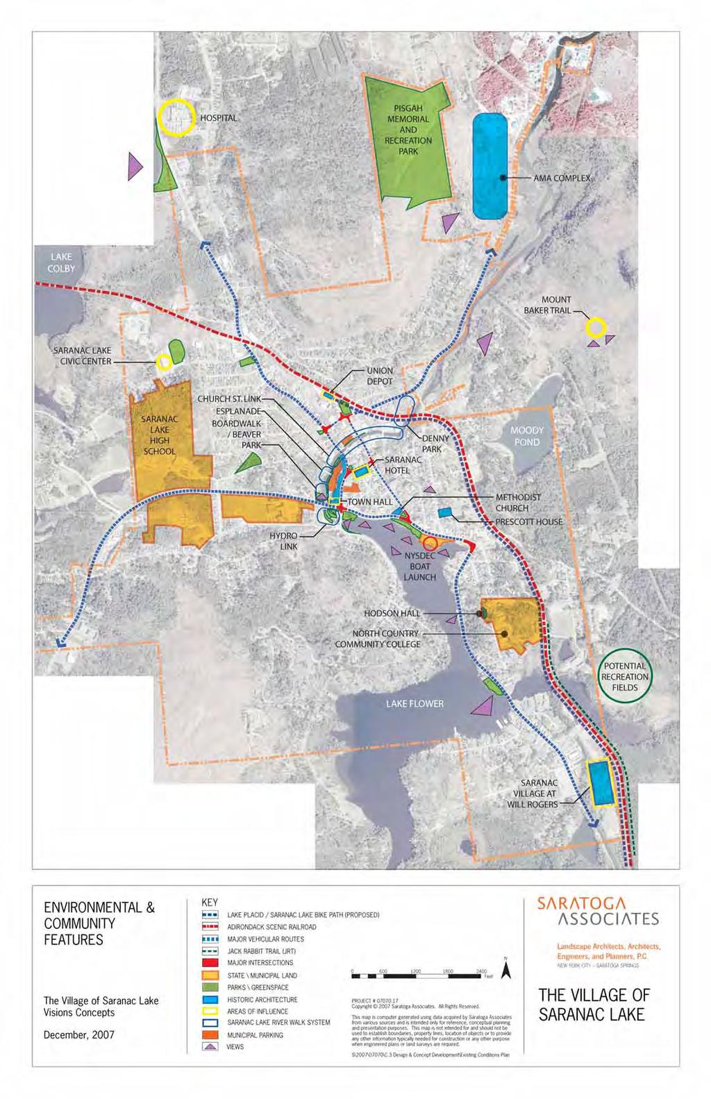
6 HOSPITAL GATEWAY (RT. 86): LAKE COLBY VIEWS / ACCESS ROUTE TO BUSINESS PARK & AIRPORT, PAUL SMITH S COLLEGE & HOSPITAL BIKE PATH MT. PISGAH MEMORIAL AND RECREATION PARK LAKE COLBY BLOOMINGDALE GATEWAY LIMITED BUILDABLE AREA NATURAL / SCENIC GATEWAY VILLAGE CORE EXISTING PARKS AND GREENSPACE RIVER, LAKE & RIVERWALK ACCESS VEHICULAR TRAFFIC CONFLUENCE MIXED USE RETAIL & RESIDENTIAL / OFFICE HISTORIC ARCHITECTURE ECONOMIC CENTER PEDESTRIAN SCALE Saranac Hotel MOODY POND WESTERN GATEWAY LIMITED ECONOMIC OPPORTUNITIES X-COUNTRY SKIING ACCESS FABRIC OF VILLAGE BEGINS FOREST PRESERVE SCHOOL AREAS RESIDENTIAL 3 EASTERN GATEWAY MIXED USE DEVELOPMENT POTENTIAL RECREATION OPPORTUNITIES ACCESS INTRODUCTION TO LAKE FLOWER MAIN TOURISM GATEWAY HIGH TRAFFIC COUNTS NCCC PROXIMITY TENNIS COURTS NORTH COUNTRY COMMUNITY COLLEGE LAKE FLOWER 4 SARANAC VILLAGE AT WILL ROGERS FRAMEWORK MAP KEY LAKE PLACID / SARANAC LAKE BIKE PATH (PROPOSED) ADIRONDACK SCENIC RAILROAD JACK RABBIT TRAIL (JRT) VILLAGE GATEWAY CORRIDORS N The Village of Saranac Lake Visions Concepts December, GATEWAY/ DEVELOPMENT DISTRICTS URBAN CORE DISTRICT Feet PROJECT # Copyright 2007 Saratoga Associates. All Rights Reserved. This map is computer generated using data acquired by Saratoga Associates from various sources and is intended only for reference, conceptual planning and presentation purposes. This map is not intended for and should not be used to establish boundaries, property lines, location of objects or to provide any other information typically needed for construction or any other purpose when engineered plans or land surveys are required. THE VILLAGE OF SARANAC LAKE S\2007\07070\C.3 Design & Concept Development\Framework Plan ai
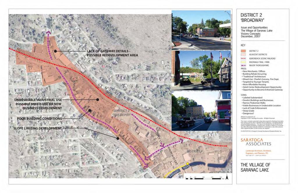
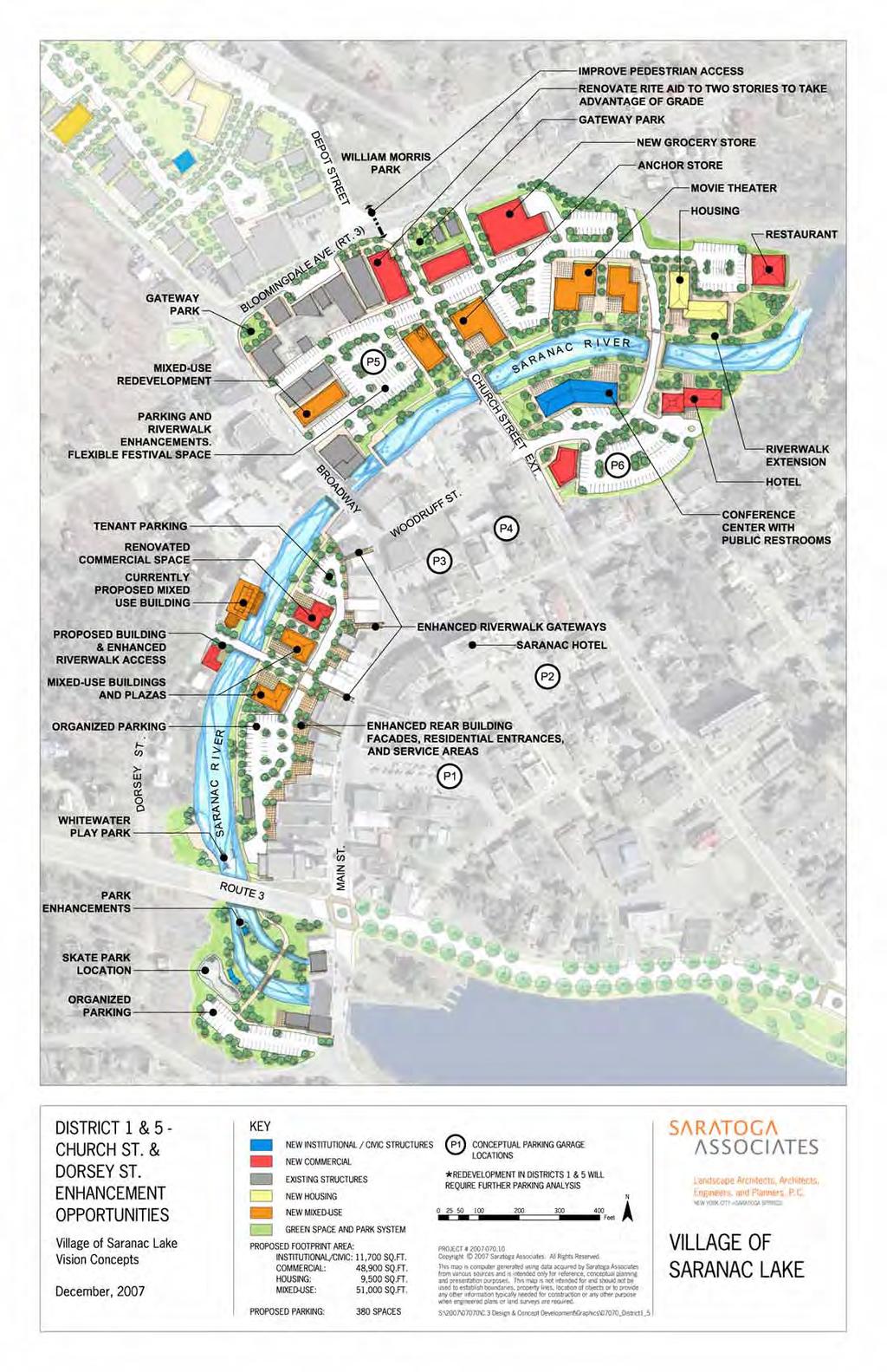
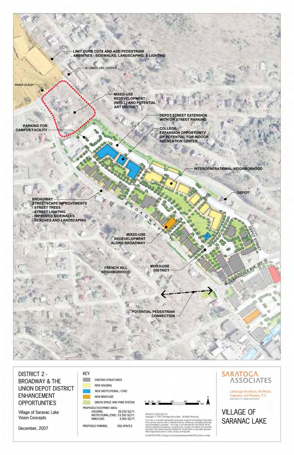
7 2 DISTRICT 2 - BROADWAY & THE UNION DEPOT MIXED USE DEVELOPMENT - SERVICE / RETAIL RESIDENTIAL - SENIOR OR WORKFORCE HOUSING ENVIRONMENTALLY FRIENDLY INDUSTRY CONFERENCE CENTER AND WORK SPACE INTERGENERATIONAL NEIGHBORHOOD ARTS & ENTERTAINMENT DISTRICT PARKS & RECREATION COMPLEX TOURISM DEVELOPMENT CAMPUS EXPANSION PUBLIC RESTROOMS SENIOR CENTER RESTAURANTS MUSEUM PARKING OFFICE DISTRICT 5 - DORSEY ST EXPANDED RIVERFRONT RECREATION AREA EXPANDED URBAN PARK & TRAIL NETWORK CIVIC & COMMUNITY CENTER IMPROVED VISUAL ACCESS IMPROVED OFFICE SPACE UPSCALE RESTAURANTS PARKING STRUCTURE URBAN RESIDENTIAL ADA ACCESSIBILITY PUBLIC RESTROOMS MEETING SPACE 5 1 Saranac Hotel 3 DISTRICT 1 - CHURCH STREET ANCHOR STORE / GENERAL MERCHANDISE CONFERENCE CENTER & MEETING SPACE MIXED USE DEVELOPMENT - RETAIL / OFFICE / RESTAURANTS OPEN SPACE PARKS / EXPANDED RIVERFRONT ACCESS GROCERY & SPECIALTY FOODS CIVIC & COMMUNITY CENTER URBAN PARK & TRAIL NETWORK HOTEL AND UPSCALE LODGING MOVIE THEATER / RESTAURANT PUBLIC RESTROOMS ADA ACCESSIBILITY PARKING OFFICE DISTRICT 3 - NORTH SHORE MIXED USE DEVELOPMENT - COMMERCIAL / RESIDENTIAL STREETSCAPE ENHANCEMENTS OPEN SPACE & PARKS PUBLIC RESTROOMS PUBLIC PARKING VISITOR CENTER DISTRICT 4 - EASTERN GATEWAY PARKS & RECREATION COMPLEX / YOUTH CENTER BUSINESS INCUBATOR \ RESEARCH FACILITY MIXED USE DEVELOPMENT RESIDENTIAL 4 DISTRICT REDEVELOPMENT PROGRAM OPPORTUNITIES KEY 1 LAKE PLACID \ SARANAC LAKE BIKE PATH (PROPOSED) URBAN CORE DISTRICT Feet N The Village of Saranac Lake Visions Concepts December, 2007 PROJECT # Copyright 2007 Saratoga Associates. All Rights Reserved. This map is computer generated using data acquired by Saratoga Associates from various sources and is intended only for reference, conceptual planning and presentation purposes. This map is not intended for and should not be used to establish boundaries, property lines, location of objects or to provide any other information typically needed for construction or any other purpose when engineered plans or land surveys are required. S\2007\07070\C.3 Design & Concept Development\PotentialProgramPlan.ai THE VILLAGE OF SARANAC LAKE
8 SARANAC LAKE VISION CONCEPTS SECTION 2: DISTRICT REDEVELOPMENT ISSUES AND OPPORTUNITIES
9
10


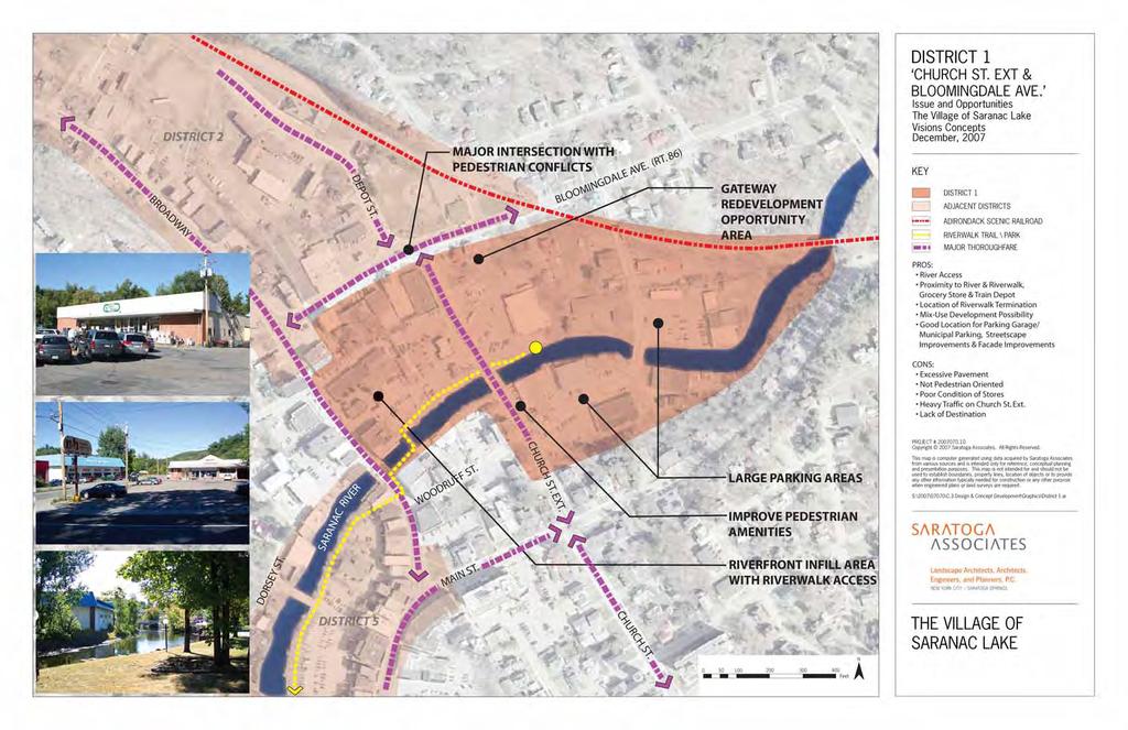
11 POSSIBLE DEVELOPMENT AREA TRAIN DEPOT - STOP ON ADIRONDACK SCENIC RAILROAD DISTRICT 2 THE DEPOT Issue and Opportunities The Village of Saranac Lake Visions Concepts December, 2007 KEY POSSIBLE CONNECTION TO BROADWAY DISTRICT 2 ADJACENT DISTRICTS ADIRONDACK SCENIC RAILROAD WAREHOUSE BUILDINGS BROADWAY DEPOT ST. BLOOMINGDALE AVE. CHURCH ST. EXT. WILLIAM MORRIS PARK RIVERWALK TRAIL \ PARK MAJOR THOROUGHFARE PROS: Tourism Gateway Historic Structure(s) Planned Carousel Installation in William Morris Park Possible Development Area Existing Artist Studio Hub for Recreational Bikers Adjacent Properties Could Provide Connection to Broadway CONS: Adjacent Industrial Site No Direction for Train Patrons Hard to Find, Not Visible NYSDOT Owns Depot Existing Building Condition PROJECT # Copyright 2007 Saratoga Associates. All Rights Reserved. This map is computer generated using data acquired by Saratoga Associates from various sources and is intended only for reference, conceptual planning and presentation purposes. This map is not intended for and should not be used to establish boundaries, property lines, location of objects or to provide any other information typically needed for construction or any other purpose when engineered plans or land surveys are required. S:\2007\07070\C.3 Design & Concept Development\Graphics\District 2.ai. SARANAC RIVER WOODRUFF ST. MAIN ST. THE VILLAGE OF SARANAC LAKE N Feet


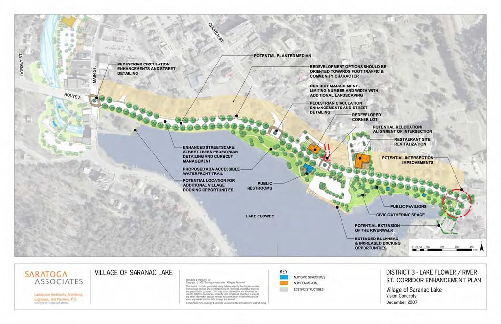
12 CHURCH ST. EXT. DISTRICT 3 THE NORTH SHORE OF LAKE FLOWER Issue and Opportunities The Village of Saranac Lake Visions Concepts December, 2007 SARANAC RIVER BROADWAY KEY DISTRICT 3 ADJACENT DISTRICTS ADIRONDACK SCENIC RAILROAD RIVERWALK TRAIL \ PARK MAJOR THOROUGHFARE DORSEY ST. MAIN ST. PROS: Existing Small Businesses Views of Lake Ability to Attract Boats / Boat Access Ability to Create Pedestrian Connection to Downtown Park Culminates with Bandshell Public Space RIVER ST. (RT. 3) CHURCH ST. CONS: NYSDEC Owns Boat Launch / No Village Accessible Property - Lacks Improvements No Public Parking NYSDEC Parking Disrupts Views Geese Bulkhead is Deteriorating No Public Restrooms or Visitor Center Undesirable Businesses (vacant Burger King) Poor Views from South West Side. Poor Pedestrian Connection to Downtown RT. 3 is Difficult to Cross and has no Pedestrian Feel. PROJECT # Copyright 2007 Saratoga Associates. All Rights Reserved. IMPROVE PEDESTRIAN AMENITIES AND CONNECTION TO DOWNTOWN MIX OF VACANT, UNDESIRABLE AND DESIRABLE COMMERCIAL USES LAKE FLOWER This map is computer generated using data acquired by Saratoga Associates from various sources and is intended only for reference, conceptual planning and presentation purposes. This map is not intended for and should not be used to establish boundaries, property lines, location of objects or to provide any other information typically needed for construction or any other purpose when engineered plans or land surveys are required. S:\2007\07070\C.3 Design & Concept Development\Graphics\District 3new Character Map.ai NYSDEC BOAT LAUNCH AND PARKING AREA RT. 86 POOR VIEWS ACROSS LAKE THE VILLAGE OF SARANAC LAKE N Feet


13 DISTRICT 4 SOUTHERN GATEWAY TENNIS COURTS, NO PARKING Issue and Opportunities The Village of Saranac Lake Visions Concepts December, 2007 KEY LAKE FLOWER FIRST VIEW OF LAKE FLOWER DISTRICT 4 ADIRONDACK SCENIC RAILROAD RIVERWALK TRAIL \ PARK MAJOR THOROUGHFARE PROPOSED SARANAC \ PLACID BIKE PATH PROS: Visitor s Introduction to Lake Flower Potential for Mixed-Use Development Proximity to NCCC and Dorms Access to Jack Rabbit Trail Ability to Connect to Future Bike Path Tennis Court Access CONS: Unrestrained Sprawl No Pedestrian Connection / Non-walkable Separate Economic Center from Downtown Sidewalk from Downtown Ends before Zone NO PEDESTRIAN AMENITIES POSSIBLE CONNECTION TO BIKE PATH PROJECT # Copyright 2007 Saratoga Associates. All Rights Reserved. This map is computer generated using data acquired by Saratoga Associates from various sources and is intended only for reference, conceptual planning and presentation purposes. This map is not intended for and should not be used to establish boundaries, property lines, location of objects or to provide any other information typically needed for construction or any other purpose when engineered plans or land surveys are required. S:\2007\07070\C.3 Design & Concept Development\Graphics\District 4new Character Map.ai NYS RT. 86 BIG BOX DEVELOPMENT, POOR GATEWAY EXAMPLE SARANAC VILLAGE AT WILL ROGERS N THE VILLAGE OF SARANAC LAKE Feet


14 DISTRICT 5 DORSEY ST. & BEAVER PARK AREA Issue and Opportunities The Village of Saranac Lake Visions Concepts December, 2007 BROADWAY KEY PEDESTRIAN CONNECTION TO OTHER DISTRICTS ACCESS FROM DORSEY ST. IS DIFFICULT TO FIND DOMINANT USE IS PARKING POSSIBLE DEVELOPMENT OPPORTUNITY DORSEY ST. SARANAC RIVER MAIN ST. WOODRUFF ST. MAIN ST. CHURCH ST. EXT. PEDESTRIAN CONNECTIONS ARE NOT INVITING CHURCH ST. DISTRICT 5 ADJACENT DISTRICTS ADIRONDACK SCENIC RAILROAD RIVERWALK TRAIL \ PARK MAJOR THOROUGHFARE PROS: Connects to Main ST. & Broadway \ Grand Entrance to Village Connects to Beaver Park Kayak Access to Slalom Course Middle and Elementary Schools Nearby Connects Under RT. 3 Municipal Parking CONS: Underutilized Riverfront \ Hidden Parking is Dominant Use Part of a Larger Parking Problem Connections From Main St. are Uninviting Signage From Main St. is Unnoticeable PROJECT # Copyright 2007 Saratoga Associates. All Rights Reserved. This map is computer generated using data acquired by Saratoga Associates from various sources and is intended only for reference, conceptual planning and presentation purposes. This map is not intended for and should not be used to establish boundaries, property lines, location of objects or to provide any other information typically needed for construction or any other purpose when engineered plans or land surveys are required. S:\2007\07070\C.3 Design & Concept Development\Graphics\District 5new Character Map.ai RIVER ST. (RT. 3) LAKE FLOWER N THE VILLAGE OF SARANAC LAKE Feet
15 SARANAC LAKE VISION CONCEPTS SECTION 3: DISTRICT REDEVELOPMENT ENHANCEMENT OPPORTUNITIES
16 HOSPITAL GATEWAY (RT. 86) BLOOMINGDALE GATEWAY WESTERN GATEWAY EASTERN GATEWAY
17
18
19
20
21
22
23 ROUTE 3 CORRIDOR - EXISTING CONDITION DISTRICT 3 - LAKE FLOWER/ RIVER STREET ENHANCEMENT RENDERING The Village of Saranac Lake Visions Concepts December, 2007 PROJECT # Copyright 2007 Saratoga Associates. All Rights Reserved. This map is computer generated using data acquired by Saratoga Associates from various sources and is intended only for reference, conceptual planning and presentation purposes. This map is not intended for and should not be used to establish boundaries, property lines, location of objects or to provide any other information typically needed for construction or any other purpose when engineered plans or land surveys are required. S:\2007\07070\C.3 Design & Concept Development\Graphics\District3-rendering\ 07070_District3-Rendering-11x17.ai THE VILLAGE OF SARANAC LAKE
24 ROUTE 3 CORRIDOR - PHASE I Pedestrian Enhancement: Special Paving and New Crosswalks Signage at Pedestrian Crossings Enhanced/ Improved Sidewalk Landscaping Existing Condition DISTRICT 3 - LAKE FLOWER/ RIVER STREET ENHANCEMENT RENDERING The Village of Saranac Lake Visions Concepts December, 2007 PROJECT # Copyright 2007 Saratoga Associates. All Rights Reserved. This map is computer generated using data acquired by Saratoga Associates from various sources and is intended only for reference, conceptual planning and presentation purposes. This map is not intended for and should not be used to establish boundaries, property lines, location of objects or to provide any other information typically needed for construction or any other purpose when engineered plans or land surveys are required. S:\2007\07070\C.3 Design & Concept Development\Graphics\District3-rendering\ 07070_District3-Rendering-11x17.ai THE VILLAGE OF SARANAC LAKE

25 ROUTE 3 CORRIDOR - PHASE II Corridor Enhancement: Bury Utility Lines Install New Lighting and Banners Redevelop Existing Properties Street Trees Existing Condition DISTRICT 3 - LAKE FLOWER/ RIVER STREET ENHANCEMENT RENDERING The Village of Saranac Lake Visions Concepts December, 2007 PROJECT # Copyright 2007 Saratoga Associates. All Rights Reserved. This map is computer generated using data acquired by Saratoga Associates from various sources and is intended only for reference, conceptual planning and presentation purposes. This map is not intended for and should not be used to establish boundaries, property lines, location of objects or to provide any other information typically needed for construction or any other purpose when engineered plans or land surveys are required. S:\2007\07070\C.3 Design & Concept Development\Graphics\District3-rendering\ 07070_District3-Rendering-11x17.ai THE VILLAGE OF SARANAC LAKE


26 PROPOSED LP/SL BIKE PATH OLYMPIC SCENIC BYWAY/ ROUTE 86 LAKE FLOWER NORTH COUNTRY COMMUNITY COLLEGE REMOVE TENNIS COURTS AND CREATE WATERFRONT PARK. WATERFRONT PARK AMENITIES TO INCLUDE DOCKS, BENCHES AND LIGHTING RETAIN RESIDENTIAL FEEL WITH SHARED DRIVES AND PEDESTRIAN AMENITIES NO DRIVE-THRU OR GARAGE DOORS ALLOWED TO FACE PRIMARY ROAD LIMIT CURB CUTS AND PROVIDE PEDESTRIAN AMENITIES SUCH AS SIDEWALKS, LANDSCAPING AND LIGHTING FUTURE SPORTS FIELDS COMPLEX POTENTIAL INDOOR RECREATION CENTER/ COMPLEX BIKE TRAIL CONNECTION WITH KIOSK AND TRAILHEAD EXTREME OUTDOOR SPORTS PARK OR MIXED-USE DEVELOPMENT - HOUSING AND COMMERCIAL PROPOSED ROAD CONNECTION ENTRANCE AND STREETSCAPE RENOVATION INCLUDING NEW COMMERCIAL BUILDINGS TO DEFINE STREETSCAPE EDGE. ESSENTIAL SERVICES DISTRICT CREATE GATEWAY DEFINITION WITH STREET TREES AND PEDESTRIAN AMENITIES SUCH AS BENCHES, LIGHTING, LANDSCAPING AND BUS STOP DISTRICT 4 - EAST GATEWAY ENHANCEMENT OPPORTUNITIES KEY LAKE PLACID \ SARANAC LAKE BIKE PATH (PROPOSED) COMMERCIAL INFILL GREENSPACE AND PARK SYSTEM The Village of Saranac Lake Visions Concepts December, 2007 ESSENTIAL SERVICES DISTRICT * CONTROL BUILDING SITE AND SCALE THROUGH DESIGN STANDARDS Feet PROJECT # Copyright 2007 Saratoga Associates. All Rights Reserved. This map is computer generated using data acquired by Saratoga Associates from various sources and is intended only for reference, conceptual planning and presentation purposes. This map is not intended for and should not be used to establish boundaries, property lines, location of objects or to provide any other information typically needed for construction or any other purpose when engineered plans or land surveys are required. N THE VILLAGE OF SARANAC LAKE S\2007\07070\C.3 Design & Concept Development\East Entry Opportunities.ai

27 EASTERN GATEWAY - EXISTING CONDITION DISTRICT 4 - EAST GATEWAY ENHANCEMENT RENDERING The Village of Saranac Lake Visions Concepts December, 2007 PROJECT # Copyright 2007 Saratoga Associates. All Rights Reserved. This map is computer generated using data acquired by Saratoga Associates from various sources and is intended only for reference, conceptual planning and presentation purposes. This map is not intended for and should not be used to establish boundaries, property lines, location of objects or to provide any other information typically needed for construction or any other purpose when engineered plans or land surveys are required. S:\2007\07070\C.3 Design & Concept Development\Graphics\southern gateway\ 07070_District4-Rendering11X17.ai THE VILLAGE OF SARANAC LAKE

28 EASTERN GATEWAY - PHASE I Pedestrian Enhancement: Special Paving and New Crosswalks Signage at Pedestrian Crossings Enhanced/ Improved Sidewalk Landscaping Building & Façade Improvements Existing Condition DISTRICT 4 - EAST GATEWAY ENHANCEMENT RENDERING The Village of Saranac Lake Visions Concepts December, 2007 PROJECT # Copyright 2007 Saratoga Associates. All Rights Reserved. This map is computer generated using data acquired by Saratoga Associates from various sources and is intended only for reference, conceptual planning and presentation purposes. This map is not intended for and should not be used to establish boundaries, property lines, location of objects or to provide any other information typically needed for construction or any other purpose when engineered plans or land surveys are required. S:\2007\07070\C.3 Design & Concept Development\Graphics\southern gateway\ 07070_District4-Rendering11X17.ai THE VILLAGE OF SARANAC LAKE

29 EASTERN GATEWAY - PHASE II Corridor Enhancement: Bury Utility Lines Install New Lighting and Banners Redevelop Existing Properties Street Trees Existing Condition DISTRICT 4 - EAST GATEWAY ENHANCEMENT RENDERING The Village of Saranac Lake Visions Concepts December, 2007 PROJECT # Copyright 2007 Saratoga Associates. All Rights Reserved. This map is computer generated using data acquired by Saratoga Associates from various sources and is intended only for reference, conceptual planning and presentation purposes. This map is not intended for and should not be used to establish boundaries, property lines, location of objects or to provide any other information typically needed for construction or any other purpose when engineered plans or land surveys are required. S:\2007\07070\C.3 Design & Concept Development\Graphics\southern gateway\ 07070_District4-Rendering11X17.ai THE VILLAGE OF SARANAC LAKE
Anatomy of A Vibrant Downtown. Anatomy of a Vibrant Downtown
 Anatomy of A Vibrant Downtown The goal of MAIN ST. REVITALIZATION PLANNING is to provide a framework that will help transform your downtown into a VIBRANT DOWNTOWN a place where people love to LIVE, WORK,
Village of Fair Haven Goals & Objectives
 Village of Fair Haven Goals & Objectives 1 Natural Environmental Quality & Aesthetics Embrace policies and programs that preserve and enhance the Village s natural resources, environment, water quality,
DOWNTOWN RESIDENTIAL DISTRICT DEVELOPMENT OPPORTUNITES
 DOWNTOWN RESIDENTIAL DISTRICT DEVELOPMENT OPPORTUNITES Out of all the areas in Downtown Painesville, this district provides the greatest opportunity for change with the vacation of Lake East Hospital.
City of Farmington. Downtown Plan. Amendment to the 1998 Master Plan Adopted October 11, 2004
 City of Farmington Amendment to the 1998 Master Plan Adopted October 11, 2004 Introduction Planning Background 1 Scope and Components of the Plan Amendment 2 Concept Introduction 3 Plan Concepts 3 Conceptual
Table of Contents. Elm Avenue Improvement Plan City of Waco, Texas. Introduction 1. Existing Context 1 Figure 1 2.
 Table of Contents Introduction 1 Existing Context 1 Figure 1 2 Plan Guidelines 3 Future Urban Form 4 The West-End 4 Main Street 6 The East-End 7 Figure 2 9 Public Improvement Recommendations 7 General
The University District envisions, in its neighborhood
 Envisioning the University District Link Light Rail in Seattle s neighborhoods CIY OF SEALE CONCEP-LEVEL SAION AREA PLANNING RECOMMENDAION RESOLUION # 30165 EXHIBI L Vision 08.2000 he University District
V. Vision and Guiding Principles
 V. Vision and Guiding Principles The Master Plan for the Powers Ferry Corridor seeks a foundation in the desires of the community. At times, various elements of the community offered opposing viewpoints,
Small Area Plan. South Gateway
 Small Area Plan Adopted May 12, 2008 South Gateway Purpose. The South Gateway Small Area Plan defines the City s expectations for the future of the southern entrance to the City at Interstate 85 and Highway
DRAFT ROOSEVELT ROAD. District Recommendations. Figure 5.23 The Roosevelt Road Corridor
 CHAPTER 5 Figure 5.23 The Road Corridor Road will develop as a mixed-use corridor, emphasizing regional retail, west of the river and mixed-use development east of the river. KEY RECOMMENDATIONS 1. High
A Plan for the Heart of the Region: Tukwila, WA
 : Tukwila, WA 1 The Plan orchestrates the Restructuring of a 1,000-acre Regional Shopping Area into a Social and Symbolic for the Region. REGIONAL CONTEXT Downtown Seattle (Metropolitan ) 20 miles Bellevue
Project Profile BAR HARBOR
 1 BAR HARBOR The Bar Harbor Master Plan merges community vision with design guidelines to preserve the unique character of Bar Harbor Village. PROJECT SUMMARY Overview: The economic vitality of Bar Harbor
Highland Falls Waterfront Redevelopment Feasibility Study Village Board Meeting March 20, 2017
 Village Board Meeting March 20, 2017 Agenda I. Public Meeting #1 Visioning Summary II. Public Meeting #2 Comment Summary III. IV. IV. Case Study: Milton Train Station Schematic Design Concepts Schedule/Next
Grantsburg Community Design Team (CDT)
") Grantsburg Community Design Team (CDT) Summary Report Overview On April 10-13, 2014, a team of (19) volunteer planners, design professionals, and community development educators volunteered their time
Grantsburg Community Design Team (CDT) Summary Report Overview On April 10-13, 2014, a team of (19) volunteer planners, design professionals, and community development educators volunteered their time
12 th Street Connector Alignment Study VISIONING PUBLIC WORKSHOP - JUNE 25, :00PM TO 8:00PM
 12 th Street Connector Alignment Study VISIONING PUBLIC WORKSHOP - JUNE 25, 2018 6:00PM TO 8:00PM Goals for Today s Workshop Agenda: Project Introduction, Purpose, and Goals Existing Conditions Traffic
Urban Analysis. Downtown Zanesville like any city, has been physically modified through time as it
 Urban Analysis As a part of the consulting team s reconnaissance effort, an urban analysis was performed. Before the future of a place can be envisioned, one must understand the physical characteristics
A Vibrant Downtown. Chapter 5 Cary Public Art Opportunities 31
 A Vibrant Downtown Cary s vision for Downtown is a unique, vibrant, dynamic, pedestrian friendly location; a regional destination and a place to live, work, and recreate, according to the 2001 Town Center
City of Long Beach. creating vibrant and exciting places
 City of Long Beach creating vibrant and exciting places Land Use Element Urban Design Element Overview of the two draft General Plan elements Discuss areas of change Economic goals of the plans Case study
Policies and Code Intent Sections Related to Town Center
 Policies and Code Intent Sections Related to Town Center The Town Center Vision is scattered throughout the Comprehensive Plan, development code and the 1994 Town Center Plan. What follows are sections
THEMES, VISION, + PRINCIPLES
 CHAPTER 2: THEMES, VISION, + PRINCIPLES This page intentionally left blank. 20 VISION DRAFT AUGUST 2018 2 2 THEMES, VISION, + GUIDING PRINCIPLES The Key Themes, Vision, and Guiding Principles presented
EXISTING COMPREHENSIVE PLAN
 EXISTING COMPREHENSIVE PLAN Town Center Land Use Element: V. LAND USE POLICIES Town Center Mercer Island's business district vision as described in "Your Mercer Island Citizen-Designed Downtown" was an
The Lower SaLuda Greenway
 The Lower SaLuda Greenway InITIaTIve a FLourIShInG Greenway. a hub For economic GrowTh. a ConneCTIon BeTween CoMMunITIeS. In April 2017 the Michael J. Mungo Foundation and Lexington County commissioned
4- PA - LD - LIVELY DOWNTOWN. LD - Background
 4- PA - LD - LIVELY DOWNTOWN LD - Background The downtown has been the service centre for the community since the city s inception and the area continues to supply people with their personal services,
Carlsbad Village Redevelopment Concept Summary of Features
 Carlsbad Village Redevelopment Concept Summary of Features Calthorpe Associates November 5, 2003 The Redevelopment Concept illustrates a vision for the future of Carlsbad Village. The overall vision of
Pedestrian and Bike Bridge LOGO
 6.2.2 Pedestrian and Bike Bridge The proposed pedestrian and bike crossing re-envisions the existing bridge at Pismo Creek on Cypress Street. The bridge is currently underutilized by vehicular through
Blue Line LRT Extension
 v e Noble Pkwy Noble Pkwy Xerxes Ave N Shingle Creek Penn Ave N Penn Ave N Fremont Ave N Lyndale Ave N S Washington Ave University Ave NE Blue Line LRT Extension LIGHT RAIL PLATFORM AND STATION DESIGN
Metro. Activity Center Design Guidelines. Recommendations For Developing Focused, Mixed-Use Commercial/Residential Centers
 Metro Activity Center Design Guidelines Recommendations For Developing Focused, Mixed-Use Commercial/Residential Centers Metro Activity Centers What is a MAC? Legacy, the adopted guide for the future growth
REGIONAL ACTIVITY CENTER
 DRAFT REGIONAL ACTIVITY CENTER 70 EAST BENCH MASTER PLAN DRAFT 06 Introduction The East Bench Regional Activity center is comprised of large educational, research, medical, and employment centers. These
Ivywild On The Creek PRELIMINARY CREEK DISTRICT MASTER PLAN
 Ivywild On The Creek PRELIMINARY CREEK DISTRICT MASTER PLAN Introduction: Rejuvenating an extraordinary Creekside neighborhood THE CREEKSIDE DISTRICT The Ivywild On The Creek Neighborhood District Master
What Pioneer Grove Will Look Like?
 The City of Deerfield Beach has embarked on a journey to create a new town center within the old heart of Deerfield Beach. The new town center is known as Pioneer Grove. Pioneer Grove will be Everybody
Animating the Rideau Canal December 2013
 Executive Summary Animating the Rideau Canal December 2013 Why study the Rideau Canal? The Rideau Canal has been an important part of Ottawa throughout its history, and has shaped and been shaped by the
CONTEXT: the Highway, the River + the Railroads run through us.
 CONTEXT: the Highway, the River + the Railroads run through us. I-25 36 In the past they have divided us, now we have an opportunity to unite us. I-76 I-270 I-76 CSU I-25 LEGEND Cut + Cover River North
Town Center (part of the Comprehensive Plan)
") Town Center (part of the Comprehensive Plan) Mercer Island Town Center Looking North (2014) In 1994, a year-long process culminated in a set of design guidelines and code requirements for the Town Center
Town Center (part of the Comprehensive Plan) Mercer Island Town Center Looking North (2014) In 1994, a year-long process culminated in a set of design guidelines and code requirements for the Town Center
Creating a Main Street Strategy A Roadmap to a Community s Future
 Creating a Main Street Strategy A Roadmap to a Community s Future Creating a Main Street Strategy A Roadmap to a Community s Future 9:00 am Session 1: Creating a Main Street Strategy A Roadmap to a Community
Visioning Statement and Guiding Principles
 Visioning Statement and Guiding Principles Planning for the Future The General Plan The General Plan represents Woodland's shared vision of the future and defines a path to lead the community toward its
DALY CITY VISIONING PROCESS COMMUNITY WORKSHOP 3 MAY 8, 2008
 DALY CITY VISIONING PROCESS COMMUNITY WORKSHOP 3 MAY 8, 2008 PROCESS General Plan - a statement of the community s values, vision and aspirations for now and into the future... Timeframe LONG TERM - 2030
Town Center. Block 5 Existing multifamily residential units are expected to remain.
 Area Guidelines Germantown s districts should be developed as distinct communities with unique features that are supported through the guidelines. The guidelines not only help distinguish these districts
TEMPLE MEDICAL & EDUCATION DISTRICT
 City of Temple, Texas TEMPLE MEDICAL & EDUCATION DISTRICT 1 Description. The City of Temple joined in partnership with key public and private entities to jointly promote education and medical activities
Land Use. Hardware Street Vendor Mixed-Use
 Land Use Definition Land Use is the way a piece of real estate is utilized. Existing, proposed, and adopted land uses all play a role in the planning process. Once a land use plan is adopted, the next
Former Rockcliffe Airbase Community Design Plan Guiding Design Vision and Principles December 4, 2013
 APPENDIX 5 - Guiding Design Vision and Principles Former Rockcliffe Airbase Community Design Plan Guiding Design Vision and Principles December 4, 2013 Vision Statement The redevelopment of the former
2-FRAMEWORK STRATEGY
 2-Framework Strategy 2-FRAMEWORK STRATEGY The Downtown Master Plan Update is based on a framework of organizational concepts that should guide investment in the area. All of the components of the plan
TEAM INPUT SUMMARY. Postcard Image?
 DOWNTOWN MAULDIN TEAM PUBLIC INPUT TEAM INPUT SUMMARY Postcard Image? A nice neighborhood The main city center with government buildings Mauldin entry sign, high school, Cultural Center, Sunset Park, Hall
WELCOME and introduction
 1 WELCOME and introduction Mobility Hub Locations within Burlington STUDY OVERVIEW STUDY OBJECTIVES The City of Burlington is developing four Area Specific Plans, one for each of Burlington s Mobility
Town of Peru Comprehensive Plan Executive Summary
 Town of Peru Comprehensive Plan Executive Communities that plan grow by choice, not by chance. A plan makes growth thoughtful, understandable, and predictable. A plan shows that a community is managing
A P P E N D I X B - O P P O R T U N I T Y S I T E S
 A P P E N D I X B - O P P O R T U N I T Y S I T E S OPPORTUNITY SITES As listed in the Land Use Element, the City has identified 15 Opportunity Sites expected to be the focus of change and revitalization
Committee Meeting: Downtown Today & Concept Refinement September 11, 2017
 Committee Meeting: Downtown Today & Concept Refinement September 11, 2017 AGENDA 1. Brief Input Update 2. Comprehensive Plan Principles 3. Downtown Today 4. Concept Updates 5. Future Schedule What is a
8implementation. strategies
 PROGRAM STRATEGIES 8implementation strategies T he implementation actions of this chapter are designed to support and carry out the land use, economic development, transportation, urban design, and program
Comprehensive Plan & Station Area Zoning
 Village of Tarrytown Comprehensive Plan & Station Area Zoning Public Workshop November 5, 2017 Warner Library WXY architecture + urban design Pace University - Land Use Law Center George M. Janes & Associates
Status Update (2006 vs. Now) Citizen s Advisory Committee February Plan for Prosperity
 Citizen s Advisory Committee February Plan for Prosperity") Status Update (2006 vs. Now) Citizen s Advisory Committee February 2018 Plan for Prosperity 2000 2017 2000 2017 Gardnerville Population 6,000 5,760 5746 5,500 5,000 5,067 5,550 5,165 5,394 5,412 5,250
Status Update (2006 vs. Now) Citizen s Advisory Committee February 2018 Plan for Prosperity 2000 2017 2000 2017 Gardnerville Population 6,000 5,760 5746 5,500 5,000 5,067 5,550 5,165 5,394 5,412 5,250
Port Credit Local Advisory Panel October 20 th Meeting
 Port Credit Local Advisory Panel October 20 th Meeting Focus Of This Evening s Meeting: 1. Hurontario Main Street Higher Order Transit Study 2. Port Credit Mobility Hub & GO Station Parking Structure Study
4 C OMMUNITY D ISTRICTS
 4 C OMMUNITY D ISTRICTS N ew development in the Area will include many different types of land uses, including a destination retail area that attracts people from all over the region; recreation opportunities
Project Goal. RRRC Living Towns Planning Workshp. Town of Halifax Revitalization Project. Dynamic Planning & Management Duo: July 12, 2006
 Project Goal Town of Halifax Revitalization Project RRRC Living Towns Planning Workshp July 12, 2006 Town of Halifax Halifax County *** Revitalization Project Goal*** To create Economic Opportunity and
Bolivar. Vision. Drury University Visioning Team
 Bolivar 2030 Vision Drury University Visioning Team Triple Bottom Line Ethical criteria for business success: environmental sustainability and social responsibility used as criteria when judging the overall
PLAN ELEMENTS WORKSHOP. April 5, 2016
 PLAN ELEMENTS WORKSHOP April 5, 2016 needs more housing. But there is no one-size fits-all solution. Every neighborhood has its own character. In some places, density is not only appropriate it is badly
Shared Principles and Emerging Plan Directions
 Shared Principles and Emerging Plan Directions Introduction Since the Fairfield Neighbourhood planning process launched in June 2016, we have heard from many residents, businesses, groups and other people
THE GAS PLANT DISTRICT MASTER PLAN SCENARIO 2. COMMUNITY MEETING August 6, 2018
 THE GAS PLANT DISTRICT MASTER PLAN SCENARIO 2 COMMUNITY MEETING August 6, 2018 The Gas Plant Neighborhood in the 1970 s The development should honor the history of the Gas Plant neighborhood and the community
Planning Districts INTRODUCTION
 INTRODUCTION To facilitate detailed examination of development prospects for all areas of the community, Delano has been divided into 14 planning districts. The location of these planning districts is
Downtown Dubuque...it s a great time.
 Downtown Dubuque...it s a great time. Your timing could not be better to invest in Downtown. With hundreds of millions in public and private investment occurring on the City s downtown waterfront, millions
Downtown North Las Vegas Demonstration Site Project. Project Update
 Downtown North Las Vegas Demonstration Site Project Project Update 7.16.14 Presentation Overview Project Purpose and Process Planning Context Opportunities and Barriers Summary Community Input Preliminary
Dyersville Downtown Plan. Open House October 24, 2017
 Dyersville Downtown Plan Open House October 24, 2017 What is a Comprehensive Plan? - Vision - Guidance for decisions - Basis for regulations What is a Downtown Plan? - Understand priorities - Identify
ARLINGTON COUNTY, VIRGINIA
 ARLINGTON COUNTY, VIRGINIA County Board Agenda Item Meeting October 15, 2005 DATE: September 28, 2005 SUBJECT: Request to Advertise the adoption of the 2005 Clarendon Sector Plan C. M. RECOMMENDATION:
The West College Avenue Corridor Redevelopment Plan
 The West College Avenue Corridor Redevelopment Plan Proposed dby Educational Property Group, Inc. & Apex Development Project Summary The intent of this proposal is to introduce market-driven mixed-use
City of Plattsburgh DRI: Downtown Streetscapes & Riverfront Access. Downtown Streetscape and Riverfront Access Design
 City of Plattsburgh DRI: Downtown Streetscapes & Riverfront Access Welcome Thank you for coming this evening. Agenda PART I - Project Context The Downtown Revitalization Program Our DRI Projects Other
3.1 community vision. 3.3 required plan elements
 Chapter 3 Community Form 3.1 community vision 3.2 Parks & landscaping concepts 3.3 required plan elements D R A F T 20 Community Form Chapter 3 3.0 Community form 3.1 community vision The Specific Plan
Charles P. Johnson and Associates. Annapolis Landscape Architects
 Charles P. Johnson and Associates Annapolis Landscape Architects AGENDA Introduction Project Limits and Scope Site Analysis Opportunities & Constraints Program Goals Image Boards Design Alternatives Pros
The Five Components of the McLoughlin Area Plan
 The Five Components of the McLoughlin Area Plan This documents contains the complete language of the five components of the McLoughlin Area Plan: The Vision Statement The Values The Guiding Principles
LUNDY S LANE COMMUNITY IMPROVEMENT PLAN STUDY
 PUBLIC INFORMATION MEETING #2 October 12, 2016 LUNDY S LANE COMMUNITY IMPROVEMENT PLAN STUDY AGENDA 5:00 to 5:30pm: Open House 5:30 to 6:15pm: Presentation 6:15 to 7:00pm: Individual paced workshop with
Lehigh Acres Land Development Regulations Community Planning Project
 Lehigh Acres Land Development Regulations Planning Effort Summary In July, 2010 Commissioner Frank Mann invited the Lehigh Acres community to start discussing how to achieve their recently adopted community
V. Gateways GATEWAYS / V-1
 V. GATEWAYS / V-1 Many of Chesapeake s gateways are located on highways and call for bold and attractive designs that motorists can understand, appreciate, and enjoy. can also take the form of natural
Technical Appendix L, University Community Plan Town Center
 Technical Appendix L, University Community Plan Town Center Table of Contents L.1 Executive Summary L.2 Merced County University Community Plan, 2004 Findings L.2.1 Visioning L.2.2 UCP Goals, Objectives
Exhibit Planning and Design Workshop February 3-6, Commissioned by the Maryland-National Capital Park and Planning Commission (M-NCPPC)
") Exhibit Planning and Design Workshop February 3-6, 2014 Commissioned by the Maryland-National Capital Park and Planning Commission (M-NCPPC) Planning and Design Workshop The Montgomery County Planning
Exhibit Planning and Design Workshop February 3-6, 2014 Commissioned by the Maryland-National Capital Park and Planning Commission (M-NCPPC) Planning and Design Workshop The Montgomery County Planning
CHAPTER 8 ISSUES, CONCERNS, CONSTRAINTS AND OPPORTUNITIES
 CHAPTER 8 ISSUES, CONCERNS, CONSTRAINTS AND OPPORTUNITIES Introduction This River Conservation Plan was developed during a time of tremendous activity and effort in planning the transformation of the Delaware
CITY OF UNION CITY MINUTES GENERAL PLAN ADVISORY COMMITTEE
 CITY OF UNION CITY MINUTES GENERAL PLAN ADVISORY COMMITTEE WEDNESDAY, MARCH 4, 2015, 6:30 P.M. IN THE CITY COUNCIL CONFERENCE ROOM OF CITY HALL 34009 ALVARADO-NILES BLVD., UNION CITY, CALIFORNIA Attachment
Ship Creek Redevelopment
 Ship Creek Redevelopment Three Concepts May 2013 Cambridge ARCHITECTURE Philadelphia ENGINEERING Raleigh INTERIORS San Francisco PLANNING Washington, DC www.klingstubbins.com contact@klingstubbins.com
John M. Fleming Managing Director, Planning and City Planner. Old East Village Dundas Street Corridor Secondary Plan Draft Terms of Reference
 Report to Planning and Environment Committee To: From: Subject: Chair and Members Planning & Environment Committee John M. Fleming Managing Director, Planning and City Planner Old East Village Dundas Street
Neighborhood Districts
 NEIGHBORHOOD DISTRICTS SEVEN MAIN DISTRICTS Neighborhood Districts While the Development Plan provides a broad-scale overview of the neighborhood, this section focuses on uses and relationships at the
Planning Board Briefing
 Planning Board Briefing Why Now? The Sector Plan Implementation Chapter States: Before Stage 1 begins, the following must occur: Approval of the Sectional Map Amendment. Approval of the Greater Lyttonsville
PINE CURVE REZONING. BACKGROUND Purchased as two parcels in 2001 and 2002
 BACKGROUND Purchased as two parcels in 2001 and 2002 WHAT THE PROJECT IS AND IS NOT A Rezoning establishes the land use standards for Annexed and Zoned Greater Downtown District Historic Center September
EXHIBIT A. Tax Increment Reinvestment Zone No. 1 (Town Center) First Amended Project Plan 1
 First Amended Project Plan 1") EXHIBIT A Tax Increment Reinvestment Zone No. 1 (Town Center) First Amended Project Plan 1 1 As amended by Resolution No. 2008-02-001(TR1R) of the Tax Increment Reinvestment Zone No.1, and approved to
EXHIBIT A Tax Increment Reinvestment Zone No. 1 (Town Center) First Amended Project Plan 1 1 As amended by Resolution No. 2008-02-001(TR1R) of the Tax Increment Reinvestment Zone No.1, and approved to
About Momentum Midland
 About Momentum Midland Achieving a community s full potential in terms of economic development and quality of life is critically important to its long term sustainability. Core to achieving this is a vibrant
PORT OF VANCOUVER WATERFRONT DEVELOPMENT. Concept Development Plan City Center Redevelopment Authority April 20, 2017
 PORT OF VANCOUVER WATERFRONT DEVELOPMENT Concept Development Plan City Center Redevelopment Authority April 20, 2017 Port History PORT ESTABLISHED 1912 TERMINAL 1 ACQUIRED 1925 GWM SIGNS LEASE 1935 HARBOR
Market Demand and Land Use
 Market Demand and Land Use Summary 57 Challenges 60-61 Guiding Principles 62 Strategy and Implementation 63-69 Establish a mix of uses that contribute to a vibrant downtown. 58 Summary Historically, downtown
Chapter 4. Linking Land Use with Transportation. Chapter 4
 Chapter 4 Linking Land Use with Transportation Chapter 4 59 Chapter 4 Linking Land Use with Transportation Community Design and Transportation Program Introduction Since the 1950s, the predominant development
Corridor Vision. 1Pursue Minnehaha-Hiawatha Community Works Project. Mission of Hennepin County Community Works Program
 1Pursue Minnehaha-Hiawatha Community Works Project Minnehaha-Hiawatha Community Works is a project within the Hennepin Community Works (HCW) program. The mission of the HCW program is to enhance how the
Al Hansen, Director of Parks and Recreation City of Petoskey, Michigan
 Al Hansen, Director of Parks and Recreation City of Petoskey, Michigan 231-347-2500 ahansen@petoskey.us What is Placemaking? Definitions Found Online: Creating a sense of place Creating a sense of belonging
WORKSHOP PURPOSE PERRY COMPREHENSIVE PLAN COMMUNITY WORKSHOP APRIL 4 TH, 2013 WHAT IS A COMPREHENSIVE PLAN? AGENDA
 WORKSHOP PURPOSE PERRY COMPREHENSIVE PLAN COMMUNITY WORKSHOP APRIL 4 TH, 2013 Provide background information on the Perry Comprehensive Plan Tap the expertise of the local experts (YOU!) Understand what
Welcome. Community Consultation Meeting November 28, Review and discuss the Bathurst Quay Neighbourhood Plan Framework
 Welcome Community Consultation Meeting November 28, 2016 Why Are We Here Today? Review and discuss the Bathurst Quay Neighbourhood Plan Framework Review and discuss an Action Plan for Implementation Next
Study Area. Capitol Way. Greening America s Capitals 11/13/2014. A Greening America s Capitals Project
 Olympia, WA: Greening Capitol Way Supporting Communities move towards sustainability is a priority for the federal government. A Greening America s Capitals Project Office of Sustainable Communities U.S.
section five BEAUTIFICATION PLAN
 section five BEAUTIFICATION PLAN BEAUTIFICATION PLAN Section Five Beautification Plan The goal of the Beautification Plan is to improve the Route 8-Sunnyland Corridor in terms of aesthetics and to create
Jodie Milkman, Vice President for Communications, Delaware River Waterfront Corporation (o) , (c) ,
 , (c) ,") NEWS RELEASE CONTACTS: Jodie Milkman, Vice President for Communications, Delaware River Waterfront Corporation (o) 215 629-3216, (c) 267-228-2004, jmilkman@drwc.org Anusha Alikhan, Director of Communications,
NEWS RELEASE CONTACTS: Jodie Milkman, Vice President for Communications, Delaware River Waterfront Corporation (o) 215 629-3216, (c) 267-228-2004, jmilkman@drwc.org Anusha Alikhan, Director of Communications,
Presentation of the Staff Draft. July 17, 2014 SSRVP Team, Area 3
 Presentation of the Staff Draft July 17, 2014 SSRVP Team, Area 3 Presentation Overview Introduction Plan Framework Plan Recommendations Implementation Next Steps and Request for Public Hearing on September
1.0 VISION STATEMENT. December 6, PRINCIPLES
 Vision Statement Lincoln Regional Airport 1.0 VISION STATEMENT 1.1 City LOCATION of AND OVERVIEW The Easton Lincoln Place Land Use Master Plan identifies the principles, goals, policies, and standards
3. STRATEGY FOR NEIGHBORHOOD SUSTAINABILITY
 3. STRATEGY FOR NEIGHBORHOOD SUSTAINABILITY This neighborhood plan focuses on assuring that Government Hill retains a high degree of sustainability, in that it conserves built resources that are part of
CHAPTER 6: Community Design and Appearance
 AGLE AREA COMMUNITY Plan CHAPTER 6 CHAPTER 6: Community Design and Appearance Community Design and Appearance How a community is designed and what a community looks like are attributes fundamental to the
DRAFT: NOT FINAL DESIGN
 T H E M E S O F S T A K E H O L D E R I N P U T GREEN INFRAST RUCTURE & EDGES STEWARDSHIP THROUGH P ARTNERSHIP AMENITIES & ANCHORS DESTINATION DISTRICT sustainable landscapes & infrastructure that are
Downtown Whitby Action Plan
 Downtown Whitby Action Plan Final Report October 2016 Table of Contents Introduction 1 Public Consultation 2 Walkability 3 Downtown Whitby Walkability Map 4 Vision 5 Goal & Objectives 6 Objective 1 7 Objective
PROPOSED REDEVELOPMENT OF THE GLEN ABBEY GOLF CLUB. STREETSCAPE DESIGN STUDY (excerpt from the Urban Design Brief) TOWN OF OAKVILLE.
 TOWN OF OAKVILLE.") PROPOSED REDEVELOPMENT OF THE GLEN ABBEY GOLF CLUB STREETSCAPE DESIGN STUDY (excerpt from the Urban Design Brief) TOWN OF OAKVILLE OCTOBER, 2016 for 2.4.2 STREETS Streets are the single largest component
PROPOSED REDEVELOPMENT OF THE GLEN ABBEY GOLF CLUB STREETSCAPE DESIGN STUDY (excerpt from the Urban Design Brief) TOWN OF OAKVILLE OCTOBER, 2016 for 2.4.2 STREETS Streets are the single largest component
THE 355/270 CORRIDOR:
 THE 355/270 CORRIDOR: Strategic Ideas for Sustaining a Livable Work Place Project Summary ACCESS LIFE DESIGN HEALTH WORK Montgomery County Planning Department The Maryland-National Capital Park and Planning
Our Legacy Projects DOWNTOWN JACKSONVILLE MASTER PLAN
 DOWNTOWN JACKSONVILLE MASTER PLAN A major component of our master plan is the creation of a strong and accessible open space and recreation system. The four most vital links in that system are our legacy
Rundel Library Elevated River Terrace Reconstruction City of Rochester, N.Y. Application Number July 2017
 Rundel Library Elevated River Terrace Reconstruction City of Rochester, N.Y. Application Number 75047 July 2017 PROJECT DESCRIPTION The Rundel Library is a nationally registered historic building surrounded
Lynn Housing Authority and Neighborhood Development. Washington Street Gateway District Plan A p r i l
 Lynn Housing Authority and Neighborhood Development Washington Street Gateway District Plan A p r i l 2 0 0 8 rendering of sagamore hill from lynnway pedestrian overpass table of contents project area