Rich Valley Greenway Master Plan. Central Greenway Connectivity Study
|
|
|
- Jerome Brooks
- 5 years ago
- Views:
Transcription


1 Rich Valley Greenway Master Plan Central Greenway Connectivity Study Dakota County Planning Commission February, 2017


2 Rich Valley Greenway Master Plan


3 Dakota County Greenway Vision Establish a County-wide system of interconnected greenways that provide multiple functions: corridor-based recreation non-motorized transportation infrastructure ecologically functioning habitat improved water quality

4 Dakota County Greenway Vision
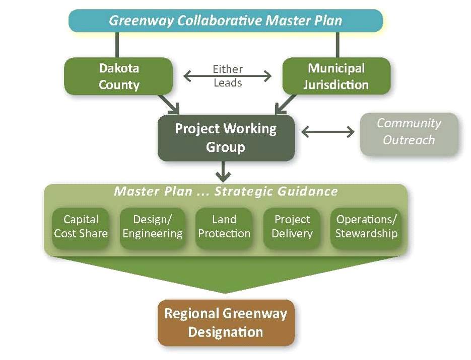
5 Collaborative Process

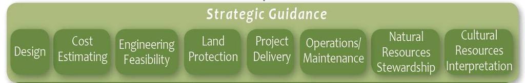
6 Master Plan Purpose & Outcomes Identify preferred greenway trail alignment Guidance for greenway development Metropolitan Council designation as a regional trail/greenway Grade separated crossings analysis & cost estimates Natural resources recommendations Cultural resources interpretation
7 Project Process November 2015-February 2016: Collect data, Natural and Cultural Resources analysis, Open House #1 February-March 2016: Analyze Alternatives, Stakeholder Outreach, Develop recommendations April 2016-February 2017: Draft Master Plan completion and review, Open House #2 March-June 2017: Final Master Plan completion and approvals
8 Public and Stakeholder Input Technical Advisory Group (TAG) : Eagan, Inver Grove Heights Project website Stakeholder outreach St. Thomas Becket Church Xcel Energy Several school and neighborhood inquiries made requesting feedback Open Houses February 16, 2016 & Spring 2017

9 Master Plan

10 Master Plan Concept

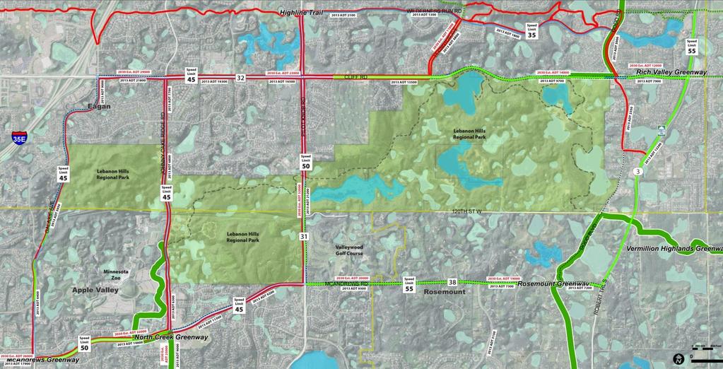
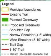
11 Segment 1 Lebanon Hills Park to Rich Valley Blvd

12 Segment 2 Rich Valley Blvd to Mississippi River Regional Trail

13 Alternative 117 th Street

14 Natural Resources

15 Water Resources

16 Transportation Grade-separated Crossings South Robert Trail at the Highline


17 Transportation Grade-separated Crossings Continuous, multipurpose trail Grade separated crossings: Recommended at all arterial road crossings Create fluid trail experience Reduce conflicts with motorized traffic Hwy 52 RR underpass


18 Transportation At-grade Crossings Continuous, multipurpose trail At grade road crossings at minor streets
19 Phasing and Priorities First Priority Build western greenway alignment along Highline corridor Lebanon Hills Park connection Eagan neighborhoods S. Robert Trail overpass Second Priority Cliff Road trail Rich Valley Park connection Trail through Flint Hills Resources land Long Term Trail through southern Inver Grove Heights

20 Phasing and Priorities
21 Next Steps Spring 2017 Public Review Summer 2017 Adoption by County Board Fall 2017 Submit to Metropolitan Council Questions?


22 Central Greenway Connectivity Study


23 Study Purpose Identify bikeway connections between 6 greenways
24 Project Purpose & Goals Identify bikeway connections between greenways, particularly for Class A Cyclists Inventory existing bikeway facilities in central Dakota County that connect regional greenways Assess conditions of existing facilities Identify opportunities for improvements Make recommendations for short and long term improvements


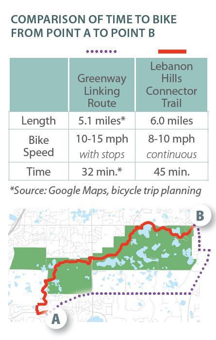
25 Cyclist Types Class A Cyclist Advanced, Experienced...commuting/utility and touring Class B Cyclist Basic, "casual, novice, occasional, recreational" Class C Cyclist Children, pre-teen Source: AASHTO Guide for the Development of Bicycle Facilities, Draft April 1995
26 Existing Conditions
27 Short Term Improvements (1-5 years) 1. Establish Greenway Linking Routes 2. Add directional signage 3. Add Bike Route signs to Greenway Linking Route 4. Enhance intersections with Sharrow bike markings 5. Convert McAndrews road design from 4 to 3 lanes with shoulders between Johnny Cake and Pilot Knob 6. Ensure consistent snow removal along Greenway Linking Route shoulders

28 Short Term Improvements
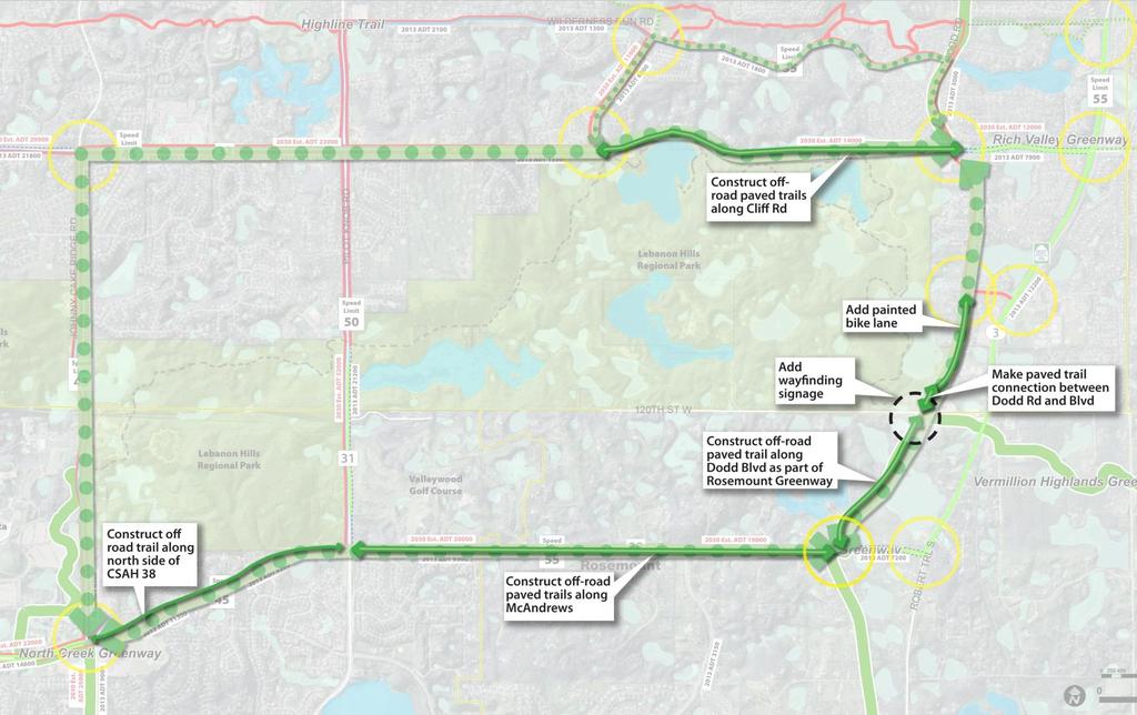
29 Long Term Improvements (5-20 years) 1. Complete trail gaps on Cliff and McAndrews 2. Add painted bike lane along Dodd Road 3. Construct trail along Dodd Blvd south of 120 th Street 4. Make paved trail connection between Dodd Rd and Blvd 5. Shoulders are designed for bicyclists along Greenway Linking Route 6. Add wayfinding signage
30 Long Term Improvements
31 Project Schedule November 2015 January 2016: Base Mapping/Existing Conditions January February 2016: Study Opportunities/Draft Recommendations, Open House March 2016 Spring 2017: Develop Report, Submit to Dakota County Board for approval
OPEN HOUSE #3. Project Manager Kristi Sebastian, PE, PTOE
 OPEN HOUSE #3 Project Manager Kristi Sebastian, PE, PTOE kristi.sebastian@co.dakota.mn.us 952-891-7100 WHY ARE WE CONDUCTING THE ARTERIAL CONNECTOR STUDY? Dakota County and the cities of Rosemount, Inver
Rosemount Greenway Master Plan Executive Summary. draft. Spring for more information visit
 Rosemount Greenway Master Plan Executive Summary Spring 2012 draft for more information visit www.hkgi.com/projects/dakota INTRODUCTION The Rosemount Greenway Master Plan portrays a vision to establish
Metropolitan Parks and Open Space Commission
 Business Item No. 2013-xxx Metropolitan Parks and Open Space Commission Meeting date: October 1, 2013 For the Community Development Committee meeting of October 7, 2013 Subject: Mendota-Lebanon Hills Greenway
Mendota-Lebanon Hills Greenway Master Plan Executive Summary. August draft for more information visit
 Mendota-Lebanon Hills Greenway Master Plan Executive Summary August 2013 draft for more information visit www.hkgi.com/projects/dakota INTRODUCTION The Mendota-Lebanon Hills Greenway Master Plan portrays
METROPOLITAN COUNCIL 390 North Robert Street, St. Paul, MN Phone (651) ; TDD (651)
 ; TDD (651)") DATE: December 20, 2011 METROPOLITAN COUNCIL 390 North Robert Street, St. Paul, MN 55101 Phone (651) 602-1000; TDD (651) 291-0904 TO: Metropolitan Parks and Open Space Commission FROM: Tori Dupre, Senior
DATE: December 20, 2011 METROPOLITAN COUNCIL 390 North Robert Street, St. Paul, MN 55101 Phone (651) 602-1000; TDD (651) 291-0904 TO: Metropolitan Parks and Open Space Commission FROM: Tori Dupre, Senior
Old Town Neighborhoods Plan. Choices Event Wednesday, December 9, 2015
 Old Town Neighborhoods Plan Choices Event Wednesday, December 9, 2015 Agenda 6:00 6:10 p.m. Welcome + Sign In 6:10 6:30 p.m. Presentation 6:30 8:00 p.m. Workshop + Open House Seeking your input on: Neighborhood
Mendota Heights 2040 Comprehensive Plan Draft Vers
 4 Parks and Trails The City of Mendota Heights boasts a variety of recreational and open space opportunities. Few cities can claim access to regional trails, riverside and lakeside parks, scenic bluffs
METROPOLITAN COUNCIL 390 North Robert Street, St. Paul, MN Phone (651) ; TDD (651)
 ; TDD (651)") DATE: October 24, 2012 METROPOLITAN COUNCIL 390 North Robert Street, St. Paul, MN 55101 Phone (651) 602-1000; TDD (651) 291-0904 TO: Metropolitan Parks and Open Space Commission FROM: Tori Dupre, Senior
DATE: October 24, 2012 METROPOLITAN COUNCIL 390 North Robert Street, St. Paul, MN 55101 Phone (651) 602-1000; TDD (651) 291-0904 TO: Metropolitan Parks and Open Space Commission FROM: Tori Dupre, Senior
ARGENTA TRAIL (CSAH 28/63) REALIGNMENT SOUTH PROJECT (CP 63-25)
 REALIGNMENT SOUTH PROJECT (CP 63-25)") ARGENTA TRAIL (CSAH 28/63) REALIGNMENT SOUTH PROJECT (CP 63-25) Preliminary Design Report February 2015 Prepared For: City of Inver Grove Heights Dakota County Prepared By: Kimley-Horn and Associates,
ARGENTA TRAIL (CSAH 28/63) REALIGNMENT SOUTH PROJECT (CP 63-25) Preliminary Design Report February 2015 Prepared For: City of Inver Grove Heights Dakota County Prepared By: Kimley-Horn and Associates,
Mendota/Lebanon Hills Greenway. Master Plan
 Mendota/Lebanon Hills Greenway Master Plan Preliminary DRAFT chapters 1 & 2-27 Feb 2013 Mendota/Lebanon Hills Greenway DRAFT Master Plan Acknowledgements Dakota County Board of Commissioners District 1
Business Item No
 Community Development Committee For the Community Development Committee meeting of December 19, 2016 For the Metropolitan Council meeting of January 11, 2017 Business Item No. 2016-255 Subject: River to
W&OD PARK MASTER PLAN. The City s Greenest Street. DRAFT W&OD Trail Master Plan v4.docx Page 1
 W&OD PARK MASTER PLAN Adopted XXX-XX-XXXX The City s Greenest Street DRAFT W&OD Trail Master Plan v4.docx Page 1 Introduction and Purpose The Washington & Old Dominion Railroad Regional Park (W&OD) (which
Welcome. Northern Segment of Hwy 100 I-90 to South of Madison Street Meeting Goals:
 Welcome Northern Segment of Hwy 100 I-90 to South of Madison Street Meeting Goals: - Review Environmental Assessment - Share Preferred Alternative -Receive Public Comments 2003 EA Preferred Alternative
Concept Master Plan. for. Draft of. Wildlife Management Area. Prepared for. June, 2008
 Draft of Concept Master Plan for Vermillion Highlands: A Research, Recreation and Wildlife Management Area Prepared for Vermillion Highlands Steering Committee - Minnesota Department of Natural Resources
Lone Oak Road/ 70 th Street West. Efficient, Effective, Responsive. Preliminary Design Services (CP 26-54)
") (CP 26-54) Dakota County Board of Commissioners September 12, 2017 Purpose of Request Award Design Contract to Kimley-Horn and Associates Approve Joint Powers Agreements with the Cities of Eagan and Inver
(CP 26-54) Dakota County Board of Commissioners September 12, 2017 Purpose of Request Award Design Contract to Kimley-Horn and Associates Approve Joint Powers Agreements with the Cities of Eagan and Inver
Route 1 Corridor Study
 Route 1 Corridor Study Westbrook, Connecticut A Vision for the Connecticut Shoreline Public Informational Meeting July 28, 2015 Lower Connecticut River Valley Council of Governments Fitzgerald & Halliday,
Trail Feasibility and Planning Project for Northern Dutchess County, New York
 for Northern Dutchess County, New York Funded in Part by Grants from the Hudson River Valley Greenway, Land Trust Alliance Conservation Partnership Program and the Thomas Thompson Trust 1 STEERING COMMITTEE
1.0 INTRODUCTION 1.1 TH 14 WEST STUDY AREA Project Description Functional Classification Purpose of the Project
 1.0 INTRODUCTION 1.1 TH 14 WEST STUDY AREA 1.1.1 Project Description The Trunk Highway (TH) 14 West Corridor is a two-lane roadway approximately 22 miles in length. Located in Nicollet County, the corridor
HILLSBOROUGH COUNTY Greenways and Trails Plan Update. Executive Summary. Date
 HILLSBOROUGH COUNTY Greenways and Trails Plan Update Executive Summary Date PURPOSE AND PROJECT OVERVIEW The Hillsborough County Greenways Master Plan (1995) and the City of Tampa s Greenways and Trails
At first Work Session on October 22, At second Work Session on November 19, At third Work Session on December 3, 2015
 At first Work Session on October 22, 2015 Staff Reviewed Infrastructure: Transportation Capacity School Capacity Willett Branch Proposed Staging Language At second Work Session on November 19, 2015 Land
Lake Marion-South Creek Greenway
 LAKE MARION-SOUTH CREEK GREENWAY MASTER PLAN 2013 Lake Marion-South Creek Greenway MASTER PLAN Executive Summary MAY 2013 DRAFT FOR MORE INFORMATION VISIT WWW.HKGI.COM/PROJECTS/DAKOTA INTRODUCTION The
Planning & Zoning Board Meeting. DRAFT Comprehensive Transportation Plan Update, February 23, 2018 version
 Planning & Zoning Board Meeting DRAFT Comprehensive Transportation Plan Update, February 23, 2018 version May 10, 2018 Overview Overview of Agency Comments Overview of proposed modifications to the Draft
City of Missoula and Missoula County Open Space Planning Open House
 City of Missoula and Missoula County Open Space Planning Open House FEBRUARY 6, 2018 The following slides contain the display board content from the open house. Please use boards to answer questions in
1.0 Introduction. Purpose and Basis for Updating the TMP. Introduction 1
 1.0 Introduction The Town of Castle Rock is situated between the metropolitan areas of Denver and Colorado Springs, amidst a unique terrain of rolling hills, mesas, ravines, and waterways. Like many Front
Rogue River Recreation and Access Management Plan- Table Rocks Reach. Jackson County, Oregon Department of Fish and Wildlife, National Park Service
 Rogue River Recreation and Access Management Plan- Table Rocks Reach Jackson County, Oregon Department of Fish and Wildlife, National Park Service Today s Agenda Welcome Project refresher Project status/timeline
2040 Long Range Transportation Plan
 2040 Long Range Transportation Plan Adopted: April 15, 2013 APPENDIX D HIGHWAY NEEDS PLAN PROJECTS FREDERICKSBURG Existing and Committed Projects Fall Hill Avenue/Mary Washington Blvd. (Fredericksburg)
Primary Contact. Organization Information. Application Multiuse Trails and Bicycle Facilities
 Application 01971-2014 Multiuse Trails and Bicycle Facilities 02195 - Regional Trail from Lebannon Hills to Downtown Regional Solicitation - Bicycle and Pedestrian Facilities Status: Submitted Date: Submitted
Fort Ord Regional Trails Planning
 Fort Ord Regional Trails Planning FORA Board July 11, 2014 Josh Metz, Associate Planner Overview Base Reuse Plan (BRP) trails planning context Trails planning in FORA jurisdictions and related entities
Whitemarsh Comprehensive Plan Update: Housing & Land Use. Public Workshop #3: September 20, 2018
 Whitemarsh Comprehensive Plan Update: Housing & Land Use Public Workshop #3: September 20, 2018 Agenda Welcome Process Recap What We ve Heard The Plan Framework Review of Recommended Actions Land Use Housing
Mary Hills Nature Area. Roadway Lighting. The Minneapolis Clinic of Neurology Courage Kenny Rehabilitation Institute
 PUBLIC REALM IMPROVEMENTS Mary Hills Nature Area Enhanced Programming Glenview Terrace Valley View Roadway Lighting Enhanced Streetscape Trail Lighting / Roadway Lighting Wayfinding Public Art The Minneapolis
Onondaga County Sustainable Streets Project. Onondaga County Planning Federation June 7, Onondaga County Sustainable Streets Project 1
 Onondaga County Sustainable Streets Project Onondaga County Planning Federation June 7, 2012 Onondaga County Sustainable Streets Project 1 Sustainable Streets 1. Introduction to the SMTC 2. Sustainable
ADOPTED CAPITAL IMPROVEMENT PROGRAM BUDGET ARROYO PROJECTS
 ADOPTED CAPITAL IMPROVEMENT PROGRAM BUDGET ARROYO PROJECTS HAHAMONGNA FY 212-216 Capital Improvement Program Priority Description Total Estimated Costs Appropriated Through FY 211 Adopted FY 212 FY 213
Toronto Complete Streets Guidelines Stakeholder Advisory Group #
 Toronto Complete Streets Guidelines Stakeholder Advisory Group #1 2015-03-24 What are Complete Streets? 2 Streets designed with all users in mind: pedestrians/those with disabilities cyclists street car
DESIGN & GREEN INFRASTRUCTURE UPDATE December 13, 2016
 DESIGN & GREEN INFRASTRUCTURE UPDATE December 13, 2016 Welcome & Introduction Michael J. Finn, P.E. City Engineer Summary of Public Outreach to Date Ground the work in established principles December 2015
5. Father Hennepin Blufs Park and Hennepin Island Father Hennepin Bluffs Park Supporting Initiatives (see Figure 36): 7-22
: 7-22") 5. Father Hennepin Blufs Park and Hennepin Island As described in existing conditions portion of Chapter 2, Father Hennepin Blufs Park lies on the upland portion of the park and Hennepin Island spans the
5. Father Hennepin Blufs Park and Hennepin Island As described in existing conditions portion of Chapter 2, Father Hennepin Blufs Park lies on the upland portion of the park and Hennepin Island spans the
PUBLIC SPACES MASTER PLAN UPDATE (POPS) Joint Facilities Advisory Commission (JFAC) November 28, 2018
 Joint Facilities Advisory Commission (JFAC) November 28, 2018") PUBLIC SPACES MASTER PLAN UPDATE (POPS) Joint Facilities Advisory Commission (JFAC) November 28, 2018 1 AGENDA POPS Planning Context Timeline Public Input Final POPS Draft Next Steps 2 PLANNING CONTEXT
PUBLIC SPACES MASTER PLAN UPDATE (POPS) Joint Facilities Advisory Commission (JFAC) November 28, 2018 1 AGENDA POPS Planning Context Timeline Public Input Final POPS Draft Next Steps 2 PLANNING CONTEXT
Small Area Plan. South Gateway
 Small Area Plan Adopted May 12, 2008 South Gateway Purpose. The South Gateway Small Area Plan defines the City s expectations for the future of the southern entrance to the City at Interstate 85 and Highway
The transportation system in a community is an
 7 TRANSPORTATION The transportation system in a community is an important factor contributing to the quality of life of the residents. Without a sound transportation system to bring both goods and patrons
PUBLIC SPACES MASTER PLAN UPDATE (POPS) Crystal City Citizen s Review Council October 24, 2018
 Crystal City Citizen s Review Council October 24, 2018") PUBLIC SPACES MASTER PLAN UPDATE (POPS) Crystal City Citizen s Review Council October 24, 2018 1 PLANNING CONTEXT Arlington County Comprehensive Plan UPDATE Related Documents: CIP Sector Plans Area Plans
PUBLIC SPACES MASTER PLAN UPDATE (POPS) Crystal City Citizen s Review Council October 24, 2018 1 PLANNING CONTEXT Arlington County Comprehensive Plan UPDATE Related Documents: CIP Sector Plans Area Plans
Date: April 10, 2017 City Council Work Session April 24, 2017: Status Report on the Comprehensive Plan Update and Transportation Master Plan
 AGENDA REPORT To: From: By: Honorable Mayor and City Council Members Warren Hutmacher, City Manager Sharon Ebert, Director Community Development Date: April 10, 2017 Agenda: City Council Work Session April
Mendota Heights 2040 Comprehensive Plan April 2019
 4 Parks and Trails The City of Mendota Heights boasts a variety of recreational and open space opportunities, including access to regional trails, riverside and lakeside parks, scenic bluffs and a nature
A larger version of this map is located on the last page of this PDF.
 MAP Committee Input McLoughlin Area Draft Vision Map A larger version of this map is located on the last page of this PDF. 1. The map above is intended to portray a vision for the McLoughlin area. It highlights
2017 General Obligation Bond
 2017 General Obligation Bond Presentation of Public and Council Projects to the Transportation & Mobility Stakeholder Committee April 13, 2017 Agenda Deferred Maintenance Project Development Process Projects
CHAPTER 7: VISION AND ACTION STATEMENTS. Noble 2025 Vision Statement
 CHAPTER 7: VISION AND ACTION STATEMENTS This chapter presents the vision, policy and action statements that transform the comprehensive planning study, an analysis of Noble s past, future trends and community
Presentation of the Staff Draft. July 17, 2014 SSRVP Team, Area 3
 Presentation of the Staff Draft July 17, 2014 SSRVP Team, Area 3 Presentation Overview Introduction Plan Framework Plan Recommendations Implementation Next Steps and Request for Public Hearing on September
4 Park Planning and Design
 4 Park Planning and Design Park Constellations Elliot Gateway/Mills Loring North Loop Commons Twins Minneapolis Park & Recreation Board Downtown Service Area Master Plan 4-1 PROJECT APPROACH REFERENCE
master plan of highways bus rapid transit amendment
 Scope of Work master plan of highways bus rapid transit amendment September 2011 Montgomery County Planning Department M-NCPPC MontgomeryPlanning.org 1 Scope of Work master plan of highways bus rapid transit
BENJAMIN BANNEKER PARK FRAMEWORK PLAN (PLAN ADOPTION)
") BENJAMIN BANNEKER PARK FRAMEWORK PLAN (PLAN ADOPTION) COUNTY BOARD MEETING DECEMBER 16, 2017 County Board Consideration: Adopt the Benjamin Banneker Park Framework Plan and Design Guidelines Framework
BENJAMIN BANNEKER PARK FRAMEWORK PLAN (PLAN ADOPTION) COUNTY BOARD MEETING DECEMBER 16, 2017 County Board Consideration: Adopt the Benjamin Banneker Park Framework Plan and Design Guidelines Framework
CITY OF CHARLOTTESVILLE, VIRGINIA CITY COUNCIL AGENDA
 CITY OF CHARLOTTESVILLE, VIRGINIA CITY COUNCIL AGENDA Agenda Date: December 16, 2013 Action Required: Adoption of Resolution Presenter: Staff Contacts: Title: James E. Tolbert, AICP, Director of NDS James
Presenting a Vision for Thread Lake
 Presenting a Vision for Thread Lake FEBRUARY 20, 2014 SPECIAL THANKS TO: International Academy of Flint Flint River Watershed Coalition South Saginaw Business and Resident Association South Side Neighborhood
Streets for People, Place-Making and Prosperity. #TOcompletestreets
 COMPLETE STREETS FOR TORONTO Streets for People, Place-Making and Prosperity COMPLETE STREETS: A NEW APPROACH A Complete Streets design approach considers the needs of all users people who walk, bicycle,
ARROYO PROJECTS ADOPTED CAPITAL IMPROVEMENT PROGRAM BUDGET
 A RROYO P ROJECTS ADOPTED CAPITAL IMPROVEMENT PROGRAM BUDGET FISCAL YEARS 214-218 HAHAMONGNA Priority Description 1 Hahamongna Watershed Park - Implement Master Plan 211,6 211,6 (77565) 2 Hahamongna -
Building Great Neighbourhoods. Strathcona
 Building Great Neighbourhoods Strathcona March 21, 2018 Becky Redford Project Manager, Planning & Design Building Great Neighbourhoods Integrated Infrastructure Services Welcome and Purpose To provide
Executive Summary. NY 7 / NY 2 Corridor
 Executive Summary NY 7 / NY 2 Corridor Transportation and Land Use Study December 2005 Prepared for: Town of Colonie Capital District Transportation Committee Prepared by: Introduction: Land use decisions
2035 General Plan Update and Belmont Village Specific Plan. Joint Study Session with the City Council and Planning Commission April 12, 2016
 2035 General Plan Update and Belmont Village Specific Plan Joint Study with the City Council and Planning Commission April 12, 2016 Agenda 1. Welcome and Introductions 2. General Plan Update Status of
SOUTHWEST TRANSITWAY (STAGE 2) PUBLIC OPEN HOUSE
 PUBLIC OPEN HOUSE") WELCOME! SOUTHWEST TRANSITWAY (STAGE 2) PUBLIC OPEN HOUSE Monday, November 18, 2013 3:30 to 5:30PM and 7:00 to 9:00PM Tuesday, November 19, 2013 3:30 to 5:30PM and 7:00 to 9:00PM Welcome to the Southwest
WELCOME! SOUTHWEST TRANSITWAY (STAGE 2) PUBLIC OPEN HOUSE Monday, November 18, 2013 3:30 to 5:30PM and 7:00 to 9:00PM Tuesday, November 19, 2013 3:30 to 5:30PM and 7:00 to 9:00PM Welcome to the Southwest
METRO Gold Line BRT CBAC Meeting. August 23, 2018
 METRO Gold Line BRT CBAC Meeting August 23, 2018 1 Today s Topics Introductions Corridor Management Committee Update Public Engagement Update History of Alignment Project Scope Discussions Upcoming CBAC
Great Rivers Greenway CLEAN GREEN CONNEC TED T RAILS
 Great Rivers CLEAN GREEN CONNEC TED T RAILS Great Rivers (GRG) was established in 2000 to create a clean, green, connected St. Louis region. Today, many new and exciting projects demonstrate the social,
WELCOME TO OPEN HOUSE TWO November 28, 2018
 Langstaff Road Weston Road to Highway 7 Class Environmental Assessment Study WELCOME TO OPEN HOUSE TWO November 28, 2018 Please sign in and join our mailing list Study Overview York Region is conducting
APPENDIX I: GREENWAY DESIGN STANDARDS
 APPENDIX I: GREENWAY DESIGN STANDARDS The goal of this report is to develop a palette of standard design elements that will help establish a distinct identify for the Bronx River Greenway. The greenway
June 14, 2017 for the June 20, 2017 Parks and Trails Commission Meeting
 105 South Fifth Avenue Suite 513 Minneapolis, MN 55401 Tel: 612-252-9070 Fax: 612-252-9077 www.landform.net TO: FROM: DATE: Corcoran Parks and Trails Commission Kendra Lindahl, Landform June 14, 2017 for
THREE-YEAR CAPITAL IMPROVEMENT PLAN FY
 THREE-YEAR CAPITAL IMPROVEMENT PLAN FY2016 2018 Annual CIP Development Process Public Works & Engineering Divisions Prepare List of Capital Needs and Recommended Deferred Maintenance Public Works & Engineering
Citizen Advisory Group Meeting 5: Land Use April 14, 2011
 Citizen Advisory Group Meeting 5: Land Use April 14, 2011 Meeting Agenda 1. Background Review 2. Transportation Follow-up 3. PED Overlay Approach 4. Land Use Mapping 5. Group Exercise 6. Wrap-up and Next
Missing Link Study Grand Rounds Parkway Planning and Design Introduction
 Missing Link Study Grand Rounds Parkway Planning and Design Introduction June 19, 2007 Minneapolis Park and Recreation Board HNTB Hoisington Koegler Group Inc. Hess Roise 1 The Missing Link Study The Minneapolis
SAFETY AND CONNECTIVITY IN A PLANNED COMMUNITY
 DALE CITY TLC SAFETY AND CONNECTIVITY IN A PLANNED COMMUNITY PROJECT KICKOFF MEETING MARCH 7, 2016 AGENDA 1. Introductions 2. Project Overview 3. Discussion 4. Site Visit PROJECT KICKOFF MEETING MARCH
Introduction. Chapter 1. Purpose of the Comprehensive Plan Plan Organization Planning Process & Community Input 1-1
 Chapter 1 Introduction Lakewood 2025: Moving Forward Together Purpose of the Comprehensive Plan Plan Organization Planning Process & Community Input 1-1 Purpose of the Comprehensive Plan The Comprehensive
Town of Lyons Parks Flood Recovery Planning Process. Photograph courtesy of Ed Bruder
 Town of Lyons Parks Flood Recovery Planning Process Photograph courtesy of Ed Bruder Lyons Parks and Recreation Flood Recovery Update 1. Meadow Park Phase II - Project PW20B1 Estimated Completion: Summer
Riverwalk Dreams compiled by Thomas P. Healy November 16, 2017
 Riverwalk Dreams compiled by Thomas P. Healy November 16, 2017 1986 Ripple Village Plan: A neighborhood plan developed by the City of Indianapolis Department of Metropolitan Development s Division of Planning
PACE CENTRAL HARLEM AVENUE CORRIDOR STUDY. Steering Committee Meeting #1 January 18, 2018
 PACE CENTRAL HARLEM AVENUE CORRIDOR STUDY Steering Committee Meeting #1 January 18, 2018 1 Agenda 1. Welcome & Introductions 2. Project Overview 3. Public Involvement Plan Highlights 4. Framing Workshop
Bethesda Downtown Plan
 Bethesda Downtown Plan Planning Board Update Connecticut Avenue Location Economic Sustainability Social Environmental Scope Coming Soon! Team Listening, Twitter Outreach We Are Here Engagement Challenge
The Illinois Department of Transportation and Lake County Division of Transportation. Route 173, including the Millburn Bypass
 The Illinois Department of Transportation and Lake County Division of Transportation welcome you to this Public Hearing for U.S. Route 45 from Illinois Route 132 to Illinois Route 173, including the Millburn
Biscuit Run Gateway. TJPDC staff recommends combining the following projects:
 Biscuit Run Gateway I. Summary: The Thomas Jefferson Planning District Commission recommends that the Metropolitan Planning Organization Policy Board vote to combine several existing projects on the Long
1.0 Purpose of a Secondary Plan for the Masonville Transit Village
 Report to Planning and Environment Committee To: Chair and Members Planning & Environment Committee From: John M. Fleming Managing Director, Planning and City Planner Subject: Masonville Transit Village
CHAPTER 1. Ms. Guajardo s Class - Central Elementary CH 1 1
 INTRODUCTION CHAPTER 1 Ms. Guajardo s Class - Central Elementary CH 1 1 1.1 SETTING South Centre City is a linear corridor south of Downtown Escondido paralleling Centre City Parkway and South Escondido
California Environmental Quality Act (CEQA) Environmental Review Process
 Environmental Review Process") California Environmental Quality Act (CEQA) Environmental Review Process Los Angeles Union Station Forecourt and Esplanade Improvements constitute a Project Los Angeles County Metropolitan Transportation
California Environmental Quality Act (CEQA) Environmental Review Process Los Angeles Union Station Forecourt and Esplanade Improvements constitute a Project Los Angeles County Metropolitan Transportation
Gratigny Parkway East Extension Project Development & Environment (PD&E) Study
 Study") Gratigny Parkway East Extension Project Development & Environment (PD&E) Study Session 4: Presentation of Charrette Results December 8, 2010 MDX Work Program #: 92407 ETDM#: 11500 Project Location & Description
Gratigny Parkway East Extension Project Development & Environment (PD&E) Study Session 4: Presentation of Charrette Results December 8, 2010 MDX Work Program #: 92407 ETDM#: 11500 Project Location & Description
Noblesville Alternative Transportation Plan 2015
 Noblesville Alternative Transportation Plan 2015 Noblesville Alternative Transportation Plan 2015 This report document was prepared under Contract for the Noblesville Department of Parks and Recreation
Potential Green Infrastructure Strategies May 6, 2015 Workshop
 Potential Green Infrastructure Strategies May 6, 2015 Workshop Background The City of Cortland is developing the Tioughnioga Urban Headwaters Green Infrastructure Action Plan with funding from the National
DOMINION BOULEVARD CORRIDOR STUDY AND ECONOMIC DEVELOPMENT STRATEGIC PLAN A MODEL FOR CHESAPEAKE S FUTURE
 DOMINION BOULEVARD CORRIDOR STUDY AND ECONOMIC DEVELOPMENT STRATEGIC PLAN A MODEL FOR CHESAPEAKE S FUTURE Overview I. Draft Plan Process II. Draft Plan Overview a. Market Analysis b. Master Land Use Plan
The Long Road from Planning to Breaking Ground:
 The Long Road from Planning to Breaking Ground: A Collaboration Between Roanoke County and VDOT Megan G. Cronise, AICP VDOT Coordinating Transportation and Land Use Planning Forum May 10, 2018 Where is
Welcome. Comprehensive Plan & Transportation Plan Open House November 7, 2012
 Welcome Comprehensive Plan & Transportation Plan Open House November 7, 2012 Agenda Proposed future land use plan Comprehensive Plan strategies Traffic forecasts Future traffic operations Possible future
Glenn Highway MP DSR. Landscape Narrative
 Glenn Highway MP 34-42 DSR Landscape Narrative Project Landscape Goals The Glenn Highway MP 34-42 Project extends through a variety of landscape types typical to the Matanuska-Susitna Valley. In general,
FY Capital Improvement Program Arroyo Projects
 FY 219-223 Capital Improvement Program FY 218 FY 219 FY 22 FY 221 FY 222 FY 223 1 2 3 4 5 6 7 8 9 1 Hahamongna - Implement Master Plan - Oak Grove Area Improvements (7756) Hahamongna - Implement Master
WHAT IS THE PURPOSE OF THE OPEN HOUSE?
 WHAT IS THE PURPOSE OF THE OPEN HOUSE? OPEN HOUSE PURPOSE The purpose of the open house is to provide an update on the study process and introduce the preliminary concept alternatives. The open house provides
Honorable Mayor and Members of the City Council. Submitted by: Eric Angstadt, Director, Planning and Development
 Office of the City Manager ACTION CALENDAR January 29, 2013 To: From: Honorable Mayor and Members of the City Council Christine Daniel, City Manager Submitted by: Eric Angstadt, Director, Planning and
CHAPTER 8. Mrs. Zimman s Class - Central Elementary
 SUSTAINABILITY CHAPTER 8 Mrs. Zimman s Class - Central Elementary 8.1 OVERVIEW Green infrastructure also known as low impact development (LID) and environmental or sustainable site design is an environmentally
CHAPTER 1 Introduction
 CHAPTER 1 Introduction From sea to summit, Lane County covers almost 4,800 square miles of diverse Oregon landscape. Stretching from the Pacific Ocean through the Coastal Range, the Willamette Valley to
S C O P E O F W O R K A P R I L
 white flint 2 sector plan S C O P E O F W O R K A P R I L 2 0 1 2 MONTGOMERY COUNTY PLANNING DEPARTMENT M-NCPPC MontgomeryPlanning.org 1 white flint 2 sector plan Scope of Work abstract This scope of work
#27. Timing: Short term. Costs: $$
 Land Use & Physical Resources PROJECT #27 Mobility S t u d y a n d i m p l e m e n t H i a w a t h a A v e n u e / M N 5 5 traffic signal improvements Environment & Natural Resources Economic Development
CITY OF INVER GROVE HEIGHTS A G E N D A CITY COUNCIL WORK SESSION June 3, :00 PM INVER GROVE HEIGHTS CITY HALL COUNCIL CHAMBERS
 CITY OF INVER GROVE HEIGHTS A G E N D A CITY COUNCIL WORK SESSION June 3, 2013 6:00 PM INVER GROVE HEIGHTS CITY HALL COUNCIL CHAMBERS 1. CALL TO ORDER Mayor Tourville 2. RENTAL REGULATIONS 3. FRONT YARD
Active Transportation Rail to River Corridor
 Active Transportation Rail to River Corridor Community Advisory Committee - Segment A, 2 nd Meeting December 13, 2016 Tonight s Agenda Purpose: Update you on Segment A & get your feedback on design concepts
Citizen s Advisory Committee
 Citizen s Advisory Committee 13 Members 6 Meetings (5 Locations) 1 Public Meeting Numerous Report Drafts Countless Hours of Review Immeasurable Input Special Thank You To: Jack Cohen Brian Kile George
Today Land & People. Northeast Nampa Gateway District. Employment. Land Use Characteristics. Demographics. Current Zoning
 Today Land & People Employment Major employers include Saint Alphonsus, the College of Western Idaho, the Auto Mall, Sorrento Lactalis and Walmart. 3,004 jobs in 2010 (COMPASS-CIM 2040 TAZ data) 4,345
MAYFIELD WEST SECONDARY PLAN PHASE 2
 MAYFIELD WEST SECONDARY PLAN PHASE 2 Public Open House #3 February 25, 2010 Draft Preferred Land Use Scenario TOWN OF CALEDON PLANNING & DEVELOPMENT DEPARTMENT Open House Agenda TOWN OF CALEDON 1. Welcome
CHAPTER VIII Implementation
 CHAPTER VIII Implementation VIII. Implementation The vision for the Marlboro Pike Corridor will require that a variety of participants work together to make it a reality. The following action steps outline
St. Clair Avenue West Area Transportation Master Plan
 1 (Between Keele Street and Old Weston Road) Public Information Centre 1 December 2, 2015 2 Welcome Welcome to the first Public Information Centre for the St. Clair Avenue West Area. The panels will present
Comprehensive Development Guide
 INDUSTRIAL ELEMENT Comprehensive Development Guide 1 Industrial Element 7.1 Hardin County Industrial Overview BG PKWY Fort Knox Industrial Corridor Comprised of 11 parcels totaling 720 acres of land 68
PREPARED FOR: PLATTEVIEW ROAD CORRIDOR STUDY EXECUTIVE SUMMARY
 PREPARED FOR: PLATTEVIEW ROAD CORRIDOR STUDY EXECUTIVE SUMMARY SEPTEMBER 2016 Introduction The Platteview Road Corridor Study was led by the Metropolitan Area Planning Agency (MAPA) with assistance from
NORTH CLAYMONT AREA MASTER PLAN COMMUNITY WORKSHOP #1 FEBRUARY 3, 2016
 NORTH CLAYMONT AREA MASTER PLAN COMMUNITY WORKSHOP #1 FEBRUARY 3, 2016 1. Introduction To the team and to the Plan Planning Partners The Claymont Community WILMAPCO New Castle County Claymont Renaissance
Parks and Open Space Preservation and Dedication. January 26, 2016 Fort Worth City Council Pre-Council Meeting Randle Harwood and Richard Zavala
 Parks and Open Space Preservation and Dedication January 26, 2016 Fort Worth City Council Pre-Council Meeting Randle Harwood and Richard Zavala Purpose How does the City of Fort Worth preserve and protect