PLANNING JUSTIFICATION REPORT
|
|
|
- Bertina Tate
- 5 years ago
- Views:
Transcription

1 80 & 85 MUNCH AVENUE CITY OF CAMBRIDGE PREPARED FOR: REID S HERITAGE HOMES ON BEHALF OF NORRICH WEST INC. PREPARED BY: LABRECHE PATTERSON & ASSOCIATES INC. VICTOR LABRECHE, MCIP, RPP PRINCIPAL, SENIOR PLANNER ALICIA MONTEITH, BES PLANNER 330 F TRILLIUM DRIVE KITCHENER, ONTARIO N2E 3J2 PHONE: FAX: DATE: JULY 7, 2016 PROJECT NO.: P
2 CONTENTS 1.0 INTRODUCTION AREA DESCRIPTION PROPOSED DEVELOPMENT PROVINCIAL POLICY STATEMENT (2014) PLACES TO GROW - GROWTH PLAN (2006) REGIONAL OFFICIAL PLAN (2010) CITY OF CAMBRIDGE OFFICIAL PLAN (2012) CITY OF CAMBRIDGE ZONING BY-LAW NO URBAN DESIGN BRIEF SERVICING CONCLUSION APPENDIX A... DRAFT PLAN OF SUBDIVISION APPENDIX B... URBAN DESIGN BRIEF ELEVATIONS APPENDIX C... URBAN DESIGN BRIEF MASSING/RENDERINGS OUR FILE: P
3 1.0 INTRODUCTION has been retained by Norrich West Inc. to provide this Justification Report in support of the Zoning By-law Amendment and Draft Plan of Subdivision applications to permit the redevelopment of the lands municipally known as 80 Munch Avenue (located on the south side of Munch Avenue) and 85 Munch Avenue (located on the north side of Munch Avenue), in the City of Cambridge. The applicant/owner is proposing to develop both properties with a total of 169 residential units in the form of street fronting townhouse dwellings. A Pre-Submission Consultation Meeting for the proposed redevelopment occurred on July 30, In support of the required Zoning By-law Amendment and Draft Plan of Subdivision, the City is requesting a Planning Justification Report including an Urban Design Brief, Traffic Noise Study, Transportation Impact Study, Tree Inventory and Management Plan, Functional Servicing Report, Architectural Cross-Sections, Draft Plan, Building Elevations, and preliminary Stormwater Management Report. 2.0 AREA DESCRIPTION Subject Lands The subject lands are located on the north side and south side of Munch Avenue, between Sekura Crescent and Kovac Road. The northern parcel has an area 23,173 square meters (5.7 acres) and the southern parcel has an area of 35,340 square metres (8.7 acres). The site was previously an automotive wrecking and salvage yard, which has since been removed and the area is undergoing remediation. Through the remediation process, a majority of the vegetation was required to be removed due to areas of contaminated soils within existing treed areas. As such, the subject lands are now vacant with existing vegetation located around the periphery of the north and south parcels. The northern parcel is currently accessed off of Munch Avenue by a driveway approximately 110 metres west of Kovac Road. The south parcel is currently accessed off of Munch Avenue by a driveway approximately 110 metres west of Kovac Road and from Sekura Crescent by Grill s Lane. See photos 1 to 3. OUR FILE: P PAGE 1

")

4 Photo 1: Aerial photo of subject lands, as outlined in red (Region of Waterloo GIS, 2014) Photo 2: Panoramic photo of north parcel of subject lands (May 25, 2016) Photo 3: Panoramic photo of south parcel of subject lands (May 25, 2016) OUR FILE: P PAGE 2


5 Surrounding Area The surrounding properties consist of residential uses, predominantly single detached dwellings with a townhouse development and semi-detached dwellings to the south of the southern parcel. The Official Plan designates the properties in proximity to the subject site as Low/Medium Density Residential. The surrounding zoning consists of RS1, R5, R6, and RM4. The property is within close proximity to the Cambridge Centre Mall, Chaplin Family YMCA, Dumfries Conservation Area, and various institutional, commercial and recreational points of interest. See photos 4 to 9 below. Photo 4: Single detached dwellings along Hilldale Drive (Google Maps) Photo 5: Single detached dwellings along Kovac Road, south of Munch Avenue (Google Maps) OUR FILE: P PAGE 3
 Photo 7: Single detached dwellings")

 OUR FILE: P-672-13")
6 Photo 6: Single detached dwellings along Kovac Road, north of Munch Avenue (Google Maps) Photo 7: Single detached dwellings along Sekura Crescent and Gills Lane, which was previously the main entrance to the automotive scrap yard and is part of the subject property (Google Maps) Photo 8: Townhouse dwellings along Rouse Avenue (Google Maps) OUR FILE: P PAGE 4

7 Notable destinations within a convenient walking distance include: Photo 9: Destinations within walking distance. RECREATION A. Greenway Chaplin Community Centre B. Cambridge Spray Pad C. Chaplin Family YMCA D. Playfit Kids Club E. Cambridge Sports Park PARKS A. Dumfries Conservation Area B. Macteith Park C. Galt Golf & Country Club D. Grills Park E. Gordon Chaplin Park F. Lion s Can Amera Park G. Greenway Park EDUCATION A. Elgin Street Public School B. Avenue Road Public School C. Christ the King Catholic Elementary School D. St. Peter Catholic Elementary School E. St. Benedict Catholic Secondary School F. Ryerson Public School RETAIL/RESTAURANTS A. Pita Hut B. Zehrs Markets C. Cambridge Centre Mall D. No Frills Grocery Store E. FreshCo Grocery Store OUR FILE: P PAGE 5
8 Transit and Accessibility to Amenities The subject lands are near several commercial, institutional and recreation uses, and have convenient access to transit. Notable destinations within walking distance (Table 1). Table 1: Walking Destinations Category Point of Interest Walking Distance (approximate) Walking Time Recreation Chaplin Family YMCA 850 metres 10 minutes Dumfries Conservation Area 1000 metres 13 minutes Grocery Store FreshCo 1400 metres 18 minutes Medical Services Grandview Medical Centre 550 metres 7 minutes Restaurant Applebee s 1400 metres 18 minutes Convenience Retail Mac s Convenience Store 850 metres 11 minutes Elementary School Elgin Street Public School 400 metres 5 minutes Christ the King Catholic Elementary School 900 metres 14 minutes In addition, the site is in close proximity to the Can-Amera/Hespeler Road Transit Node and three GRT bus routes: ixpress 200: An express route from Conestoga Mall, through Charles Terminal and Fairview Mall, to Ainslie Terminal; The closest stop is at Hespeler Road and Can Amera Parkway, approximately 850 metres (or a 10 minute walk) from the site. Route 60: travels from Cambridge Centre Mall in a loop through the Fiddlesticks neighbourhood. There are two stops located adjacent to the subject property, at Munch Avenue and Sekura Street and Munch Avenue and Kovac Road. Route 51: travels from the Ainslie Street Terminal to Hespeler neighbourhood, with stops including the Cambridge Centre Mall and Hespeler Smart Centre. The closest stop is at Hespeler Road at Munch Avenue, approximately 200 metres (or a 2 minute walk) from the site. OUR FILE: P PAGE 6

9 Photo 10: GRT Transit Routes. 1. Can-Amera (200, 60, 51) 2. Hespeler/Munch (51, 60) Hespeler (51) 4. Munch/Sekura (60) 5. Munch/Kovac (60) 6. Munch/Elgin (60) 7. Elgin/Sekura (60) 3.0 PROPOSED DEVELOPMENT The proposed use and development of the site consists of: - Construction two new streets. Street A will provide access to dwellings on the northern parcel and will connect to Munch Avenue and Hilldale Avenue. Street B will provide access to dwellings on the southern parcel and will connect Munch Avenue in two locations, opposite Street A and opposite Hilldale Drive. - Construction of 16 blocks of townhouse dwellings consisting of a total of 84 residential units within the north parcel and 16 blocks of townhouse dwellings with a total of 85 dwelling units within the southern parcel. - Construction of a stormwater management facility to be located on a 10,295 square metre block in the southern parcel. OUR FILE: P PAGE 7
10 - Construction of pedestrian walkways from the easterly sidewalk adjacent to Street B to the existing pedestrian sidewalk on Warren Road and from Street A to connect with an existing walkway on Kovac Road between residential dwellings - Dedication of lands for the purpose of a road widening along Munch Avenue from both the north and south parcels, in accordance with the City of Cambridge Official Plan. Please refer to the plans and drawings accompanying this submission package for additional details. 4.0 PROVINCIAL POLICY STATEMENT (2014) The 2014 Provincial Policy Statement (PPS), issued under the authority of Section 3 of the Planning Act, came into effect on April 30, All applications submitted after April 30, 2014 shall be consistent with this policy. This document promotes building healthy, livable and safe communities, providing an appropriate mix of different land use types within the community, efficient use of services and facilities, maximizing opportunities for public transit use, and promoting intensification. All Planning Applications, including Zoning By-law Amendment Applications and Draft Plan of Subdivisions, are required to be consistent with the policies contained within the PPS (2014). Specifically, the following sections provide direction for development and support the proposed development of the subject site: Section 1.1.1: Healthy, livable and safe communities are sustained by: a. promoting efficient development and land use patterns which sustain the financial well-being of the Province and municipalities over the long term; b. accommodating an appropriate range and mix of residential (including second units, affordable housing and housing for older persons), employment (including industrial and commercial), institutional (including places of worship, cemeteries and long-term care homes), recreation, park and open space, and other uses to meet long term needs; c. avoiding development and land use patterns which may cause environmental or public health and safety concerns; e. promoting cost-effective development patterns and standards to minimize land consumption and servicing costs; OUR FILE: P PAGE 8
11 g. ensuring that necessary infrastructure, electricity generation facilities and transmission and distribution systems, and public service facilities are or will be available to meet current and projected needs. Section : Settlement areas shall be the focus of growth and development, and their vitality and regeneration shall be promoted. Section : Land use patterns within settlement areas shall be based on: a) densities and a mix of land uses which: 1. efficiently use land and resources; 2. are appropriate for, and efficiently use, the infrastructure and public service facilities which are planned or available, and avoid the need for their unjustified and/or uneconomical expansion; 3. minimize negative impacts to air quality and climate change, and promote energy efficiency; 4. support active transportation; 5. are transit-supportive, where transit is planned, exists or may be developed; and 6. are freight-supportive; and b) a range of uses and opportunities for intensification and redevelopment in accordance with the criteria in policy , where this can be accommodated. Section : Planning authorities shall identify appropriate locations and promote opportunities for intensification and redevelopment where this can be accommodated taking into account existing building stock or areas, including brownfield sites, and the availability of suitable existing or planned infrastructure and public service facilities required to accommodate projected needs. Section : Municipal sewage services and municipal water services are the preferred form of servicing for settlement areas. Intensification and redevelopment within settlement areas on existing municipal sewage services and municipal water services should be promoted, wherever feasible. Section 1.7.1: Long-term economic prosperity should be supported by: e) promoting the redevelopment of brownfield sites. OUR FILE: P PAGE 9
12 We are of the opinion that the Zone Change Application and Draft Plan of Subdivision will facilitate the intensification of the subject lands in a way that is compatible with the surrounding community. The proposed Zoning By-law Amendment and Draft Plan of Subdivision are consistent with the policy direction of the PPS through the redevelopment of an existing, previously incompatible site into a compatible use, and the efficient utilization of infrastructure and facilities. Further, the proposal supports PPS policies on brownfield sites as well as intensification in general and specifically residential intensification as defined by the PPS. 5.0 PLACES TO GROW - GROWTH PLAN FOR THE GREATER GOLDEN HORSESHOE (2006) The proposed development also complies with the Growth Plan for the Greater Golden Horseshoe (Growth Plan) which was originally issued in 2006 and last updated in June 2013 to manage growth for the Greater Golden Horseshoe area of Ontario. While there are similar policies in the Growth Plan to that of the PPS, the Growth Plan further endorses intensification and redevelopment of a property for the creation of new units, site or area at a higher density than currently exists; residential densities to support frequent and accessible transit service; and a pedestrian-friendly built environment along roads to encourage walking to transit. proposal conforms to the overall policies of the Growth Plan, including its Guiding Principles, for the following reasons: - The site is located within the Built Up Area under the Regional Official Plan and is appropriately designated to permit the proposed use under the City of Cambridge Official Plan; - The project is an infill development and promotes intensification and development of compact communities; - The residential project is compatible with adjacent residential land uses; - The proposal will optimize existing municipal services and all of the required municipal infrastructure and other services are available and is an efficient form of land use; The Both the PPS and the Growth Plan are implemented though the inclusion of appropriate policies in the local (the Regional and lower tier) municipal Official Plans. We are of the opinion that the Zoning By-law Amendment and Draft Plan of Subdivision conforms to the Growth Plan as it OUR FILE: P PAGE 10
 The Regional Official Plan (2010) came into full force and effect on June 18, 2015. The ROP designates the subject lands as Built-Up Area (Figure 1).")
13 allows for the appropriate intensification of the subject property and is further supported by the brownfield redevelopment policies in the Growth Plan. 6.0 REGIONAL OFFICIAL PLAN (2010) The Regional Official Plan (2010) came into full force and effect on June 18, The ROP designates the subject lands as Built-Up Area (Figure 1). Lands within this designation have the greatest capacity to accommodate growth and serve as the primary focus for employment, housing, cultural, and recreation opportunities in the Region. The ROP encourages development within the Built-Up Area as designated by the Province of Ontario. The subject lands are wholly located within the Built-Up Area. The ROP encourages appropriate intensification of lands within the Built-Up Area and requires development to be serviced by municipal services. Subject Properties Figure 1: Region of Waterloo Official Plan, Map 3a - Urban Area Specifically, the following policies provide direction for development and support the proposed development of the subject site: ROP Policy 2.G.9: Major Transit Station areas are lands typically located within a 600 to 800 metre radius of a rapid transit station. Following the completion of the Rapid Transit OUR FILE: P PAGE 11
14 Environmental Assessment, the Region will designate these station areas conceptually on Map 3a through a future amendment to this Plan. Major Transit Station Areas will be planned and developed to achieve: a) Increased densities that support and ensure the viability of existing and planned rapid transit service levels; and b) A mix of residential, office, institutional and commercial development, wherever appropriate. ROP Policy 2.G.9: Area municipalities will establish policies in their official plans and, where appropriate, Community Improvement Plans and other implementation tools that promote the development of previously developed land, such as brownfield sites and greyfield sites located throughout the Urban Area and Township Areas. The proposed development is an appropriate intensification of residential land uses which is compatible with surrounding residential uses and is to be fully serviced by municipal services. Therefore, the proposed development conforms to the Region of Waterloo Official Plan. 7.0 CITY OF CAMBRIDGE OFFICIAL PLAN (2012) The City adopted a new Official Plan (OP) in May The OP includes changes taken from Provincial Planning Policy including the PPS and Growth Plan. The OP has been approved by the Region of Waterloo on November 21, 2012 and amended by the Ontario Municipal Board on April 22, Currently, specific policies of the OP remain under appeal; however, the Official Plan policies currently under appeal do not relate to the subject property or proposed Zoning By-law Amendment and as such, the policies applicable to this application should be considered in full force and effect. The subject property is designated Low/Medium Density Residential in the City of Cambridge Official Plan (Figure 2). The Low/Medium Density Residential designation permits the development of single detached dwellings, townhouses and/or walk up apartments as well as low intensity commercial, institutional and mixed use developments, where municipal water supply and municipal wastewater systems are currently available. OUR FILE: P PAGE 12

15 Within lands designated as Low/Medium Density Residential, a maximum of 40 units per hectare is permitted. The subject development on the north parcel is proposed at 36.4 units per hectare and the south parcel is proposed at 24 units per hectare. The lands are within a 750 metre distance from the proposed Can-Amera/Hespeler Road LRT Station Stop and as such, meet the criteria for being located within a Major Transit Station Area, as defined by the Regional Official Plan and City Official Plan. Subject Properties Figure 2: City of Cambridge Official Plan, Map 2 General Land Use Plan Specifically, the following policies provide direction for development and support the proposed development of the subject site: Policy : Intensification is encouraged throughout the built-up area of Cambridge, particularly within the following areas: f) Major Transit Station Areas in accordance with Section Policy : The development of land or existing buildings in the Urban Growth Centre, Community Core Areas, Nodes, Regeneration Areas, Reurbanization Corridors and Major Transit Station Areas is encouraged for mixed uses such as residential with office, commercial, and business uses. The City may provide support for mixed use development by: b) Requiring and assisting where appropriate with the remediation of contaminated sites. OUR FILE: P PAGE 13
16 Policy : Infill, intensification and redevelopment within existing neighbourhoods will be minor in nature and will be designed to respect existing character and provide connections and linkages where possible. Policy Major Transit Station Areas 1. Major Transit Station Areas are lands typically located within a 600 metre to 800 metre redius of a rapid transit station. 2. The Region will delineate the general alignment of the rapid transit system and designate areas conceptually through a future amendment to the Regional Official Plan. The City will designate Major Transit Station Areas on one or more Maps and establish associated policies through an amendment to this Official Plan. 4. Major Transit Station Areas will be planned in consultation with the Region to: a) Achieve increased residential and employment densities to support and ensure viability of existing and planned transit service levels; c) Development located within an existing or planned Major Transit Station Area will be planned and designed based on the principles of transit oriented development in accordance with Section 5.3 of this Plan. 6. Until such time as such policies for Major Transit Station Areas are established, any application for development submitted within a Major Transit Station Area will be reviewed in accordance with the transit oriented development provisions described in Section 5.3 of this Plan and in Section 2.D.6 of the Regional Official Plan. Policy : The City will promote the maintenance of an adequate supply of both ownership and rental housing stock to meet the varying needs of City residents by: a) Encouraging residential intensification and the development of multi-unit residential development in the Urban Growth Centre, Community Core Areas, Nodes, Regeneration Areas, Reurbanization Corridors and Major Transit Station Areas; b) Providing opportunities for the development of smaller lot single and semi-detached dwellings, plexes, townhouses and apartments; Policy : The City will allow compatible higher density residential development in the Urban Growth Centre, Community Core Areas, Nodes, Regeneration Areas, Requrbanization Corridors, Major Transit Station Areas and high density residential designations to support and ensure viability of existing and planning transit service levels. OUR FILE: P PAGE 14
17 Policy 5.3: Transit Oriented Development 1. Development located within a Major Transit Station Area or within walking distance of one or more higher frequency transit stops will be planned and designed based on the principles of transit oriented development and will address the following: a) Compact urban form and a mix of medium and high density uses are encouraged along arterial roads, transit routes and within walking distance of transit station areas to encourage transit use and reduce travelling distances; Policy : In accordance with the approved Regional Official Plan, Regional Transportation Master Plan and Provincial initiatives the City will support transit supportive densities in the following areas to assist in strengthening the public transit system including: f) Major Transit Station Areas. Policy A: Can-Amera/Hespeler Road Community Node 2. This node is proposed Major Transit Station Area and as such will be developed at transit supportive densities and at a pedestrian scale. Residential Compatibility The Official Plan requires development within existing communities to be compatible with the surrounding uses as per the criteria of Section Residential Compatibility. The proposed development has considered the various requirements to ensure a compatible development is being proposed, which will not hinder the surrounding residential uses. Table 2 outlines the criteria to determine residential compatibility as per Section of the Official Plan and the proposed development s design response. OUR FILE: P PAGE 15
18 Table 2: Considerations for Residential Compatibility Residential Compatibility (Official Plan Section ) a) The density, scale, height, massing, visual impact, building materials, orientation and architecture character of neighbouring buildings and the proposed development; b) The conservation, protection, maintenance and potential enhancement of the natural environmental and cultural heritage resources; c) Continued viability of neighbouring land uses; d) Pedestrian and vehicular movement and linkages, as well as parking requirements and design in both existing development and proposed developments; e) Landscaping, setbacks, sun and shadow effects, wind effects, signage, lighting and buffering of existing development and proposed developments; Design Response in Proposed Development Townhouse dwellings are a similar scale, height, massing and visual impacts as surrounding residential uses. Proposal is at a marginally higher density which will not significantly impact surrounding uses. Orientation, architecture and building materials will be complimentary to existing uses. The previous auto wrecking salvage yard use contaminated natural environmental treed features on site, which required removal for the remediation of the area. Natural environment was enhanced through remediation and natural elements will be replanted. Proposal does not hinder the continued use of the surrounding uses as residential uses and would further support this neighbourhood. The construction of two streets and various pedestrian linkages throughout the proposed neighbourhood and to the existing immediately surrounding neighbourhood, will improve access. Parking requirements are being met and align with existing conditions in the surrounding neighbourhood. The proposal will not significantly vary from the structure of the existing surrounding residential uses and result in a significant negative impact on the various features mentioned. Further vegetation will be planted around the periphery of the development where possible as a buffer for existing residences. f) Noise attenuation; The residential nature of the development will not result in an unreasonable increase or a different type of noise, as compared to the existing residential neighbourhood. g) Odour, dust, and emissions impacts; The residential nature of the development will not result in an unreasonable increase of odour, dust or emissions, as compared to the existing residential neighbourhood. h) Transportation implications; and The traffic as a result of the residential use will be filtered to Munch Avenue and should not have a significant impact on the surrounding local streets. For further information, please refer to the Traffic Impact Study completed for the proposal. i) Transitions between different land uses and between sites having varying permitted uses. The proposal is for a residential use, which is surrounded by residential uses. As such, no transition should be required. OUR FILE: P PAGE 16
19 Additionally, redevelopment projects such as the proposed intensification considered as infill and redevelopment within existing neighbourhoods, must be considered minor in nature and compatible with the surrounding neighbourhood character (Official Plan Section ). The proposed development will consist of a comparable building height, similar massing and scale, and similar lot coverage and side yard setbacks to neighbouring housing. The proposed dwellings are comparable to that of the surrounding residential uses. The building material and character of the proposed dwellings complements the character of the existing neighbourhood. Finally, the development and construction of two new streets and the diversion of traffic onto Munch Avenue will result in minimal transportation implications and facilitate appropriate parking arrangements and traffic movement through the subject lands. Based on the foregoing, we are of the opinion that the proposed development is minor in nature and is compatible with the surrounding neighbourhood character. Location Criteria for Multi-Unit Residential Development The Official Plan requires multi-unit residential development to meet the criteria of Section Location Criteria for Multi-Unit Residential Development. The definition of multi-unit residential development is a group of 4 or more attached dwelling units, including row houses and apartment buildings. The criteria are to ensure that mutli-unit residential development is located on appropriate lands with access to necessary infrastructure to support the development. The proposed development has considered the various requirements to ensure a compatible and appropriate location to a multi-unit residential development. Table 3 outlines the criteria as per Section of the Official Plan and the development proposal s design response. Table 3: Location Criteria for Multi-Unit Residential Development Location Criteria (Official Plan Section 8.4.3) a) Development is located on an arterial or collector road, or is directly accessible to any such road through the local road network where it is not likely to generate sufficient traffic to disturb the peaceful and quiet enjoyment of neighouring residential properties located on such local access road; b) Development is conveniently located within reasonable distance of public Design Response in Proposed Development The proposed development will be located on two new local streets, connecting directly to Munch Avenue (collector road), with one access to Hilldale Drive (local street). Thereby, the majority of traffic will have direct access to a collector road with a minority of traffic accessing the collector road along a short section of a local street. As outlined in Section 2 of this report, the site is within convenient walking and driving distance to OUR FILE: P PAGE 17
20 transit, recreational open space and shopping facilities and, if the building is proposed to be designed for occupancy by households with children, is also located within convenient walking distance of an elementary school; c) Development has a suitable size and configuration to: i. Permit the separation or appropriate integration of on-site vehicular and pedestrian traffic; ii. Provide for adequate access and circulation by emergency vehicles; iii. Provide adequate on-site landscaping to: establish suitable outdoor amenities and recreational facilities for the building s occupants; screen parking areas; and provide effective buffering and screening to ensure the privacy of outdoor recreational areas on the site as well as on adjoining properties; iv. Provide adequate grading and stormwater management features to ensure the drainage of surface waters to on-site stormwater management facilities or to public storm drainage facilities and not to adjoining properties; d) Development is proposed to be developed in such a manner and at such a scale that the site and building design, building height, setbacks, landscaping and vehicular circulation will ensure the proposed development is compatible with existing development on adjoining lands, as outlined in Section of this Plan; and e) Development will include wherever possible the preservation and protection of the natural environmental and cultural heritage resources. public transit facilities (lower and higher order facilities), recreation centres, shopping centres, open space and elementary schools. See below. The construction of two new streets and sidewalk facilities provide sufficient infrastructure to support vehicular and pedestrian traffic on-site leading to abutting municipal streets and sidewalks. The design facilitates the appropriate necessary access and circulation by emergency vehicles. The proposal will include appropriate landscaping for the residential uses on a lot by lot basis. Additional landscaping features will be incorporated throughout the site where necessary, including as part of the stormwater management facility and along streets. A stormwater management pond will be incorporated into the south parcel. Site grading will ensure that stormwater is drained to this new proposed stormwater management facility and/or to the public storm drainage sewers located within Munch Avenue and Hilldale Drive. The development satisfies this condition, as outlined in Table 3. The development preserved natural features which were not within impacted soil areas from the previous use on the property (auto wrecker & salvage yard). The remaining features have been removed or remediated to improve the natural and future living environment on-site. OUR FILE: P PAGE 18

21 The proposed development satisfies the Official Plan s location criteria for multi-unit residential development and as such, has demonstrated that the multi-unit residential development is proposed to be located in an appropriate location. We are of the opinion that the proposed development complies with the City of Cambridge Official Plan as the proposed use is permitted within the Low/Medium Density Residential designation of the subject property. Furthermore, through design considerations, the proposed development conforms to the policies of Section Residential Compatibility and Section Location Criteria for Multi-Unit Residential Development. 8.0 CITY OF CAMBRIDGE ZONING BY-LAW NO The subject property is currently zoned Residential (R4) (Figure 3). The R4 zone permits a detached one-family dwelling and a residential special care facility. In order to advance the proposed development, a Zoning By-law Amendment is required to zone the property to the RM4 zone, subject to a holding provision and site specific provisions, to permit the proposed municipal street fronting attached one-family dwellings (linear row houses). Three proposed Blocks (33, 36 and 38) are proposed to be rezoned as OS1. Subject Properties Figure 3: City of Cambridge Zoning By-law Map (City of Cambridge GIS) OUR FILE: P PAGE 19
22 Section 10.7 of the City of Cambridge Official Plan states that: 1. By-laws using the holding symbol (H) or (h) will specify the purpose for the holding symbol and will include a statement outlining conditions under which the holding symbol shall be removed by amendment to the City s Zoning By-law. An amending by-law to remove the holding symbol may be considered when the applicable issues are addressed: This would be applicable in various cases such as item (j) in Section 10.7 as follows: j) Remediation of environmental contamination in a manner that meets applicable criteria set by the Province in conjunction with the requirements of any other approval authorities and as prescribed in Policy 3.B of this Plan; The applicant is requesting a holding (H) provision, as permitted in the aforementioned OP section, subject to the applicant providing a Record of Site Condition acknowledgement by the Ministry of Environment and Climate Change. Additionally, the applicant is requesting the following site specific provisions, which would apply to Blocks 1 to 32, and 39 as it relates to the requested RM4 zone for the subject lands: 1. Minimum lot area of 150 square metres; 2. Minimum rear yard setback of 7.0 metre; 3. Minimum exterior side yard setback of 3.5 metres; 4. Maximum lot coverage of 52% 5. Minimum lot frontage of 4.7 metres (requested for one lot). The requested site specific provisions are necessary in keeping with related intensification policies of the Official Plan and provides for a better urban design and streetscape as the dwellings are located closer to the street at the corner lots. The site specific provisions are intended to permit the proposal to develop in the most efficient and transit supportive manner, and to further contribute to achieving the goals and objectives of the Official Plan regarding development within the Major Transit Station Areas. OUR FILE: P PAGE 20

23 9.0 URBAN DESIGN BRIEF This section Urban Design Brief was prepared with the assistance of Orchard Design Studio Inc. in support of the Zoning By-law Amendment and Draft Plan of Subdivision application submission for the subject lands. Proposed Draft Plan Various concept plans were considered to explore the options for maximizing development while reducing impacts on the adjacent residential uses. The proposed Draft Plan has been developed with consideration of surrounding existing residential uses, remnant vegetation after remediation, pedestrian and vehicular access, building layout, and the required stormwater management pond. Figure 4: Draft Plan of Subdivision for 80 & 85 Munch Avenue, Cambridge. OUR FILE: P PAGE 21
24 The proposed Site Plan consists of a total of 39 blocks: - 32 blocks of multi-family residential in the form of street fronting linear townhouse dwellings - 2 blocks dedicated for road widening - 3 blocks dedicated for walkways - 1 block for a stormwater management facility - 1 block for open space The 32 blocks of multi-family residential are proposed to consist of a total of 169 freehold townhouse units; 84 units located on the north parcel and 85 units located on the south parcel. The development proposes the construction of two new streets, one on the north parcel and one on the south parcel. Street A, located on the north parcel, will be accessed from Munch Avenue and Hilldale Drive. Street B, located on the south parcel, will be accessed from Munch Avenue and both proposed entrance points. Both Street A and B have been designed to align with existing or proposed entrances as a measure to increase safety for motorists, cyclists and pedestrians. Policy Framework All development within the City of Cambridge is expected to demonstrate a high standard of urban design that supports the creation of a unique, identifiable space while respecting and enhancing the cultural and natural heritage of Cambridge. Section 5 of the City of Cambridge Official Plan establishes urban design policies which apply to all development within the City, including the proposed development. In response, the following tables and responses demonstrate how the development satisfies the objectives of Section 5 of the City of Cambridge Official Plan. Table 4: City of Cambridge Urban Design Objectives Urban Design Objectives (Official Plan Section 5.1) a) Create an attractive, accessible, safe and healthy built environment; Design Response in Proposed Development The proposed development satisfies this objective, as outlined and elaborated throughout this report. The design and materials of the dwellings are aesthetically pleasing and the proposed design accounts to various safety concerns for residents, pedestrians, cyclists and drivers. The proposed development follows CPTED principles. OUR FILE: P PAGE 22
25 b) Enhance connectivity to allow for ease of travel throughout the city by multiple modes of transportation; c) Protect and enhance public views and vistas of natural and built features; d) Achieve high quality design for the public and private realm; e) Ensure compatibility in scale, form, massing and height transition between new development and existing buildings and adjacent neighbourhoods while being sensitive to the context; f) Encourage the incorporation of sustainable design features into the built environment; g) Promote a high standard of urban design as a key factor in establishing attractive and well integrated development throughout the community; h) Integrate urban design into the development approval and decision making process of the City; i) Ensure the development is sensitive to and respectful of the physical and functional identity and the heritage attributes of Cambridge; j) Allow for creativity in design expression while ensuring compatibility and quality of development; k) Design our community at the pedestrian scale in support of fostering social interaction, active streetscapes and walkable neighbourhoods; and l) Prepare and use urban design guidelines and standards. The proposed development is along a Collector Road, close to a Highway and Arterial Road, within close proximity to a Major Transit Station Area and is well serviced by public transportation routes. In addition to new access roads into the subject lands including municipal sidewalks, pedestrian walkways have been provided to abutting streets being Kovac Road and Sekura Street. The subject lands do not hinder public views and vistas of natural and built features. The design of the development enhances the existing public realm along Munch Avenue and proposes a high quality design for the new components of the development. The proposed townhouse dwellings will be similar in height to the surrounding single detached, semi-detached and townhouse dwellings. The materials and design is complimentary to what is existing in the neighbourhood and the scale of the development, although moderately intensified, is sensitive to the surrounding residences. Sustainable design features will be considered at the detailed design stage. The proposed development satisfies this criteria as it has been established that the proposal incorporates a high standard of urban design. Not applicable. The proposed design, type, materials and layout of the development is sensitive to and respectful of the physical and functional identity and the heritage attributes of Cambridge, as applicable. The proposed development balances the expression of a complementary design while ensuring compatibility and quality of development. The proposed development includes sidewalks, walkway connections and porches into the design of the dwellings to support the fostering of social interaction, active streetscapes and walkable neighbourhoods. Not applicable in this case. OUR FILE: P PAGE 23
26 In addition to the objectives of Section 5.1 of the Official Plan, Section 5 further establishes policies for the successful implementation of each objective in Table 5. In response, the following responses demonstrate how the development satisfies the applicable policies of Section 5 of the City of Cambridge Official Plan. Healthy and Liveable Communities and Transit Oriented Development Sections 5.2 and 5.3 of the Official Plan define policies for the healthy, compact development of neighbourhoods. The proposed development incorporates features to encourage a sustainable, healthy, active lifestyle for residents by providing pedestrian sidewalks; connecting the proposed neighbourhood to the surrounding neighbourhood by constructing and enhancing pedestrian walkways; enhancing connections to streets and paths that are able to safetly accommodate different modes of transportation; and proposing a walkable neighbourhood within a close proximity to a variety of commercial, recreational and educational uses, as well as public transportation. Additionally, the proposed development is within a Major Transit Station Area, which encourages a compact urban form and a higher density uses, while preserving and enhancing the pedestrian environment to encourage access to public transit. The proposed development will provide a higher density but compatible land use with enhanced pedestrian connections to satisfy the requirements of Section 5.2 and 5.3 of the Official Plan. Site Development and Buildings In response to Section 5.7 Site Development and Buildings, see Table 5 below: Table 5: Site Development and Buildings Site Development and Buildings (Official Plan Section 5.7) Design Response in Proposed Development 1. Development will be: See below. a) Compatible in terms of massing and scale with the existing and planned streetscape; The proposed development will be a similar massing and scale as other dwellings located in the neighbourhood. The building setbacks will also be similar to the surrounding dwellings. b) Integrated into the existing The proposed development will be integrated streetscape; and c) Provide appropriate transitions in height to adjacent buildings. into, and enhance, the existing streetscape. The height of the proposed dwellings is two storeys; whereas the surrounding dwellings are either one or two storyes. The proposed OUR FILE: P PAGE 24
27 development requires no additional height transition as it is already comparable in height. 2. Buildings will be situated at or near the street edge to frame the street and will have consistent front yard setbacks with adjacent buildings. 3. Blank building walls are discouraged along street frontages. Active facades will be required in the design and treatment of buildings at street edges and intersections and should include features such as transparent windows and public entrances facing the street unless there is no other feasible option. 4. Building materials and architectural features for development or site/building improvements within the Community Core Areas will be respectful of the local context. 5. Site layout shall incorporate pedestrian walkways and connections to encourage and enhance walkability and access. Pedestrian connections on site will connect directly with public sidewalks and transit stops unless there is no other feasible alternative. 6. Placement of outdoor lighting will complement the building design and prevent or minimize impacts on the night sky and adjacent properties. The impact of lighting will be reviewed through the site plan approval process. 7. Pedestrian scale lighting shall be provided to accent walkways, steps, ramps, building entrances, building parking facilities and transit stops. 8. Servicing, loading, waste storage areas and building utilities/mechanical equipment will be located internal to the building or to the rear of the building where possible and will be screened from view from adjacent streets. The proposed design situates the townhouses with a front yard setback of 6.0 metres throughout the development. The front yard setback is similar to adjacent buildings. The proposed townhouses will not incorporate blank walls along street frontages. Not applicable. The proposed development will include the construction of pedestrian sidewalk facilities and the connection of pedestrian walkways to existing or planned walkways onto Kovac Road and Sekura Street. Detailed design of outdoor lighting facilities will be established through the site plan approval process. Detailed design of pedestrian lighting facilities will be established through the site plan approval process. The proposed townhouses will not require large scale servicing, loading, waste storage areas or building utilities/mechanical equipment. Urban Design Studies As per Section 5.15 of the Official Plan, a specific Urban Design Study may be required to be submitted by the development proponent to the satisfaction of the City to address matters OUR FILE: P PAGE 25


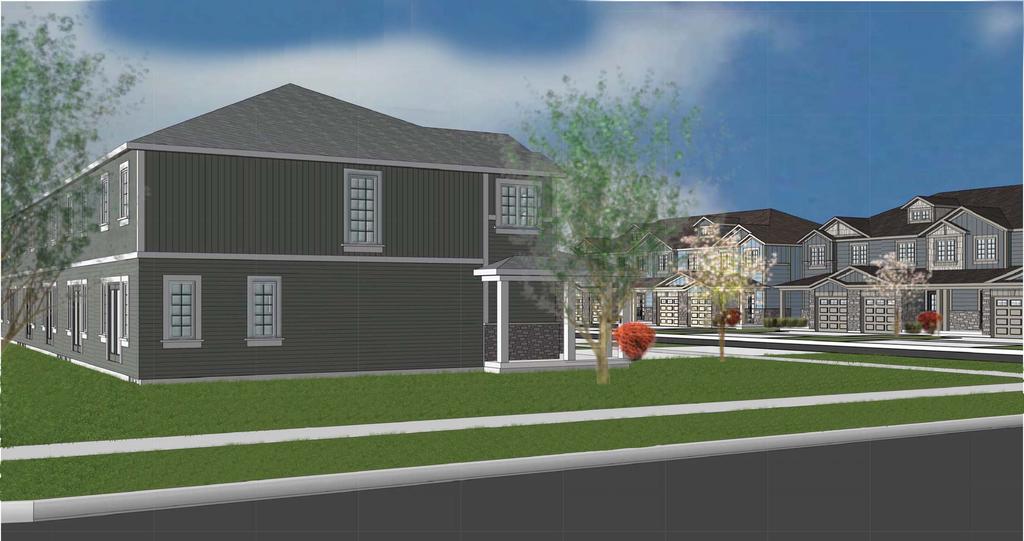
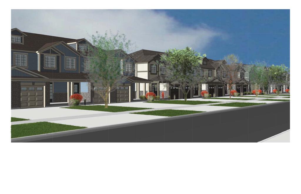
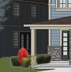
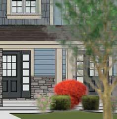
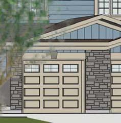
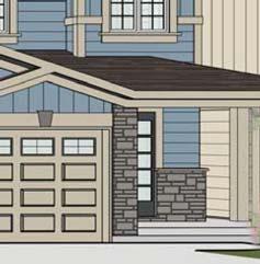
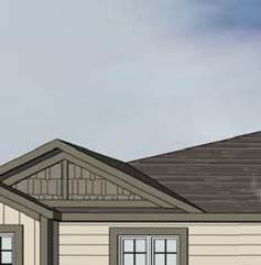
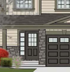
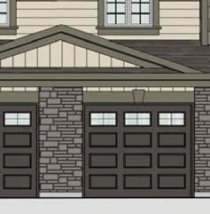
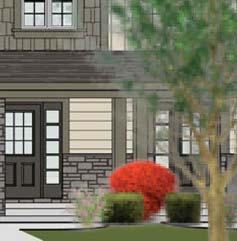
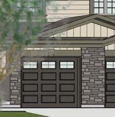
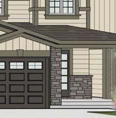
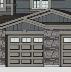
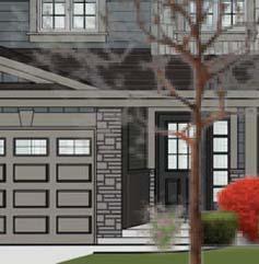
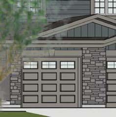
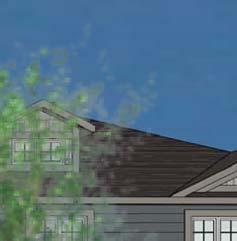
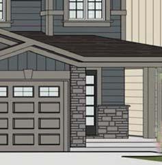
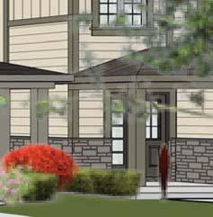
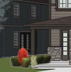
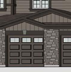
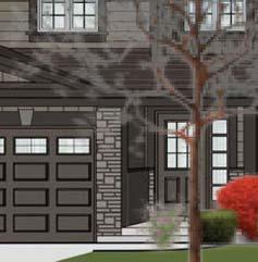
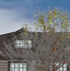
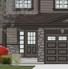
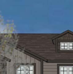
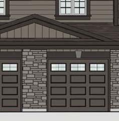
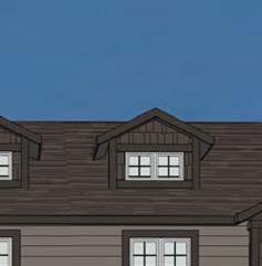
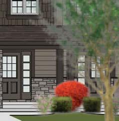
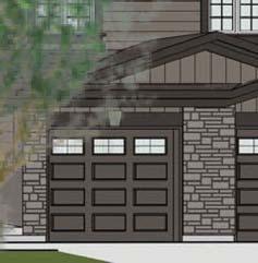
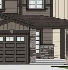
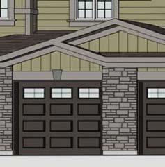
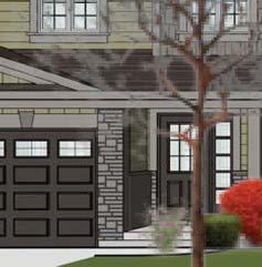
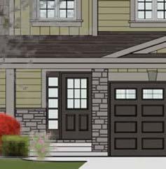
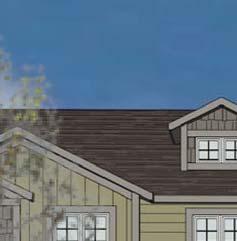
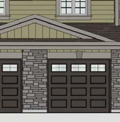
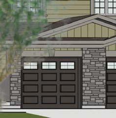
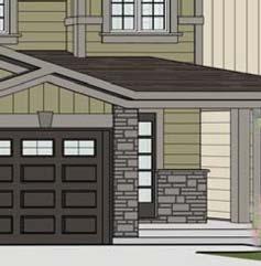
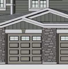
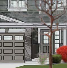
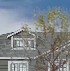
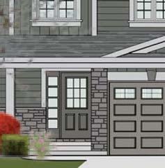
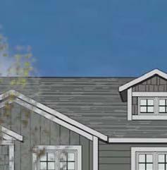
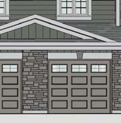
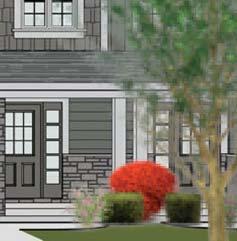
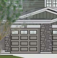
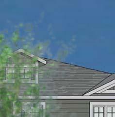
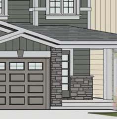
28 relating to the urban design of a proposed development. With regards to the proposed development, this requirement and the items listed in Section were discussed with City Staff and it was advised that the proponent could generally address these items in a Urban Design Brief section within the Planning Justification Report. Design Principles Landscape Design The landscape for the proposed development addresses both the aesthetic and functional landscape needs of the proposal. Section 5.1 of the Official Plan requires development plans aim to achieve high quality design for the public and private realm. A Tree Inventory and Management Plan was requested from the City as part of the proposed application. The Plan identifies existing vegetation on site and provides guidelines for protection and enhancement of those features through the development process. Additionally, a more specific Landscape Plan will be produced during the Site Plan Approval phase of the development approvals process. At this time, it is the intent of the developer to protect and enhance the existing natural features on site and to incorporate a high quality of landscape design into the proposed development, again which will be detailed at the later Site Plan Approval stage. Architectural Design The urban townhouse units have been designed to be visually appealing, livable, and fit within the fabric of the surrounding community. The townhouses have been designed as 2 storey residential dwellings and the building materials were chosen to incorporate the desired design of the developer, while remaining complimentary and similar to that of the surrounding community. In addition, the dwelling units at the end of each townhouse block will include wrap around porches, with extended rooflines over the wrap around porches into the exterior (street facing) side yards. Representative building elevations/massing and material are illustrated below: OUR FILE: P PAGE 26


")
 Please refer to")


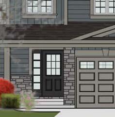
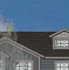
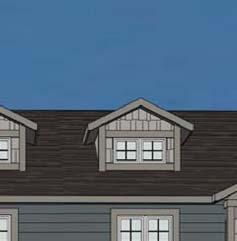
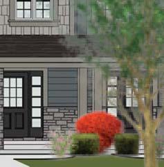
29 Photos 11 through 19: Renderings of the proposed townhouses and potential materials/colors (for illustrative purposes) (Orchard Design Studio Inc.) Please refer to Appendix B and C for details relative to the building massing and elevations. OUR FILE: P PAGE 27
30 10.0 SERVICING Functional Servicing Report and Preliminary Stormwater Management Report For additional details on the proposed subdivision site servicing please see the Functional Servicing Report prepared by MTE Consultants Inc. included in the Zoning By-law Amendment submission CONCLUSION The proposed development is consistent and does not conflict with both the Provincial Policy Statement as well as the Places to Grow Growth Plan for the Greater Golden Horseshoe. The proposal also complies with the relevant policies of the Region of Waterloo Official Plan and City of Cambridge Official Plan. The current zoning of the subject lands is R4. An amendment to rezone the subject lands to RM4 zone is necessary to permit the development of street fronting townhouse dwellings on site. The proposed development consists of the construction of two new streets, 169 residential townhouse units on 32 blocks, a stormwater management facility, and pedestrian sidewalk facilities and walkway connections throughout the development. The development is located in an area of Cambridge that is within close proximity to several elementary schools, conservation areas, parks, recreation facilities, public transit services, health care services, and commercial uses including the Cambridge Centre Mall. The development removed an incompatible industrial type use from within the center of a residential neighbourhood, remediated the site, and proposes a higher density form of residential uses in a way which is respectful and compatible with the surrounding residences. Through careful consideration of applicable planning policies, the goal of increasing density while preserving healthy environment and ensuring compatibility with neighboring uses will result in a safe, appealing and livable development and an improved community. It is our professional opinion that the requested Zoning By-law Amendment and Draft Plan of Subdivision is appropriate for the redevelopment of these lands based on the following: - This form of development is supported by all applicable Provincial Policy documents. OUR FILE: P PAGE 28
31 - The proposal conforms to the Regional Official Plan. - The proposal conforms to the City of Cambridge Official Plan and satisfies the policies regarding Residential Compatibility and Location Criteria for Multi-Unit Residential Development. - The redevelopment of the subject lands from a previous incompatible industrial type use to a residential use, which improves the quality of the neighbourhood. - The proposed design of the townhouse dwellings compliments the character of the surrounding neighbourhood. - Site Plan Approval will be required. Through this process, further site design and landscaping related items will be addressed. Based on the foregoing, it is our professional opinion that the requested Zoning By-law Amendment and Draft Plan of Subdivision is appropriate for the redevelopment of these lands and represents good land use planning. Alicia Monteith, BES Planner Victor Labreche, MCIP, RPP Principal, Senior Planner OUR FILE: P PAGE 29
32 APPENDIX A DRAFT PLAN OF SUBDIVISION
33
34 APPENDIX B URBAN DESIGN BRIEF ELEVATIONS
35 EXAMPLE COLOUR PACKAGES Package #1 Shingles dual grey Siding royal - granite shakes northwoods - granite gray Trim royal - gray 04 Pillar pt to match gray 04 Stone StoneRox - dry stack stone loyalist Front Door BM HC-166 Kendall Charcoal Garage Door BM HC-168 Chelsea Gray Package #2 Shingles driftwood Siding royal - olivewood Shakes northwoods - natural clay Trim royal - royal clay 913 Pillar pt to match royal clay 913 Stone StoneRox - precision ledge sandstone beach Front Door BM night horizon Garage Door BM night horizon ASPHALT SHINGLES PRE-FIN. TRIM VERTICAL SIDING HORIZ. SIDING SQUARE COLUMNS CULTURED STONE 23' 8" (7.2 m) BUILDING HEIGHT Package #3 Shingles Driftwood Siding royal - wedgewood Shakes northwoods - pacific blue Trim royal - pebble clay Pillar pt to match royal pebble clay Stone StoneRox - lime stone kawartha ridge Front Door BM stonecutter Garage Door pt to match royal pebble clay UNIT A (1) STANDARD END UNIT A (2) UNIT B (3) FRONT ELEVATION UNIT A (4) ENHANCED END ENHANCED ELEVATION (EXPOSED ENDS) UNIT A (4) RIGHT SIDE ELEVATION Package #4 Shingles Driftwood Siding royal - pebble clay Shakes northwoods siding - sable brown Trim royal - comm brown Pillar pt to match royal pebble clay Stone StoneRox - precision ledge delhi harvest Front Door BM CC-542 Willow Garage Door BM CC-542 Willow Package #5 Shingles Weatherwood Siding royal - wicker Shakes northwoods - savannah wicker Trim royal - cactus 6700 Pillar pt to match cactus Stone StoneRox - dry stack stone beaverton bronze Front Door BM CC-542 Willow Garage Door BM CC-542 Willow Package #6 Shingles Dual Black Siding royal - ironstone Shakes northwoods - granite gray Trim royal - charcoal Pillar BM HC-168 Chelsea Gray Stone StoneRox - precision ledge charcoal/loyalist grey Front Door BM Jet Black Garage Door BM HC-168 Chelsea Gray MUNCH AVENUE "ARTISAN" TOWNHOMES PROPOSED ELEVATIONS ROOF VENT ASPHALT SHINGLES FASCIA & EAVE. VERTICAL SIDING PRE-FIN. TRIM HORIZ. SIDING UNIT A (4) ENHANCED END UNIT B (3) REAR ELEVATION UNIT A (2) UNIT A (1) STANDARD END STANDARD ELEVATION UNIT A (1) LEFT SIDE ELEVATION
36 APPENDIX C URBAN DESIGN BRIEF MASSING/RENDERINGS

37
38
39
40
41


42


43


44


45

46
URBAN DESIGN BRIEF URBAN DESIGN BRIEF 721 FRANKLIN BLVD, CAMBRIDGE August 2018
 URBAN DESIGN BRIEF URBAN DESIGN BRIEF 721 FRANKLIN BLVD, CAMBRIDGE August 2018 DESIGN BRIEF CONTENTS PART A 1.0 INTRODUCTION 2.0 DESCRIPTION & ANALYSIS OF SITE CONTEXT 3.0 DESIGN CONSTRAINTS AND OPPORTUNITIES
CONTENTS 8.0 LAND USE 8.1 GENERAL LAND USE 8.2 RESIDENTIAL 8.3 MIXED USE 8.4 COMMERCIAL 8.5 EMPLOYMENT LANDS
 8-2 Land Use 8.0 LAND USE CONTENTS 8.1 GENERAL LAND USE 8.1.1 Uses provided for in all Land Use Designations 8.1.2 Uses prohibited in Hazardous Lands, Hazardous Sites and Special Policy Areas 8.1.3 Uses
URBAN DESIGN BRIEF. Saginaw Subdivision 124 SAGINAW PARKWAY, CAMBRIDGE OCTOBER 2015 OUR FILE 1422A
 URBAN DESIGN BRIEF Saginaw Subdivision 124 SAGINAW PARKWAY, CAMBRIDGE OCTOBER 2015 OUR FILE 1422A Contents 1.0 INTRODUCTION AND SITE DESCRIPTION... 1 2.0 MUNICIPAL DESIGN DIRECTION... 7 3.0 MASTER CONCEPT
PLANNING JUSTIFICATION REPORT
 PLANNING JUSTIFICATION REPORT 55 DELHI STREET CITY OF GUELPH PREPARED FOR: VESTERRA PROPERTY MANAGEMENT PREPARED BY: LABRECHE PATTERSON & ASSOCIATES INC. SCOTT PATTERSON, BA, CPT, MCIP, RPP PRINCIPAL,
URBAN DESIGN BRIEF. 2136&2148 Trafalgar Road. Town of Oakville
 URBAN DESIGN BRIEF 2136&2148 Trafalgar Road Town of Oakville Prepared By: METROPOLITAN CONSULTING INC For 2500674 Ontario Inc November 2016 TABLE OF CONTENTS Page No. 1.0 Introduction/Description of Subject
and services The protection and conservation of environmentally significant and sensitive natural heritage features and functions.
 6. Land Use 6.0 Preamble A healthy and livable city is one in which people can enjoy a vibrant economy and a sustainable healthy environment in safe, caring and diverse neighbourhoods. In order to ensure
Figure 1- Site Plan Concept
 Figure 1- Site Plan Concept Parking will be provided underground on three levels at rate of 1.0 space/ unit; this rate includes all visitors parking. MMM Group has prepared a parking assessment (April,
Urban Design Brief. Watson Parkway North & Watson Road North Guelph, Ontario. Prepared by Coletara Development
 Urban Design Brief Watson Parkway North & Watson Road North Guelph, Ontario Prepared by Coletara Development December, 2013 Urban Design Brief, Coletara Development 1 Introduction This Urban Design Brief
2136 & 2148 Trafalgar Road Town of Oakville Region of Halton
 PLANNING JUSTIFICATION REPORT 2136 & 2148 Trafalgar Road Town of Oakville Region of Halton Zoning By-Law Amendment Application 2500674 Ontario Inc. November 2016 Table of Contents Page 1.0 Location/Summary
REPORT PLANNING JUSTIFICATION Hespeler Road City of Cambridge ZONING BY-LAW AMENDMENT. Date: November 2017
 PLANNING JUSTIFICATION REPORT ZONING BY-LAW AMENDMENT 256-258 Hespeler Road City of Cambridge Date: Prepared for: 258 Hespeler Cambridge Inc. Prepared by: MacNaughton Hermsen Britton Clarkson Planning
178 Carruthers Properties Inc.
 178 Carruthers Properties Inc. Planning Rationale for 178 Carruthers Avenue Site Plan Control Application June 2014 Table of Contents 1.0 Introduction 2.0 Overview of Subject Property 3.0 Current Zoning
K. SMART ASSOCIATES LIMITED
 Planning Justification Report Zoning By-Law Amendment 185 King Street North Waterloo, Ontario April 7th, 2017 Project Reference Number 16-245 K. SMART ASSOCIATES LIMITED CONSULTING ENGINEERS AND PLANNERS
TABLE OF CONTENTS 1.0 INTRODUCTION... 3
 TABLE OF CONTENTS 1.0 INTRODUCTION... 3 1.1. BACKGROUND... 3 1.2. THE PROPOSAL... 5 2.0 EXISTING POLICY FRAMEWORK... 5 2.1. PROVINCIAL POLICY STATEMENT (PPS)... 5 2.2. CITY OF LONDON OFFICIAL PLAN (OP)...
ELMVALE ACRES SHOPPING CENTRE MASTER PLAN
 ELMVALE ACRES SHOPPING CENTRE MASTER PLAN Contents 1.0 INTRODUCTION... 2 2.0 LOCATION... 2 3.0 EXISTING CONTEXT... 2 4.0 VISION & GUIDING PRINCIPLES... 2 5.0 LAND USE AND BUILT FORM... 4 5.1 St. Laurent
ONTARIO MUNICIPAL BOARD
 PL 120483 ONTARIO MUNICIPAL BOARD Applicant/Appellant: 2124123 Ontario Limited Subject: OPA, Rezoning and Draft Plan of Subdivision Municipal Address: 3940 Highway 7 East Municipality: City of Markham
PORT WHITBY COMMUNITY
 PORT WHITBY COMMUNITY SECONDARY PLAN UPDATE COMMUNITY IMPROVEMENT PLAN URBAN DESIGN GUIDELINES September 2015 DRAFT PROPOSED AMENDMENT NUMBER # to the Whitby Official Plan PURPOSE: The intent of this Amendment
Corporation of the City of Cambridge Planning and Development Committee Meeting No
 Corporation of the City of Cambridge Planning and Development Committee Meeting No. 02-19 Historic City Hall - 46 Dickson Street Tuesday, January 29, 2019 7:00 p.m. AGENDA Meeting Called to Order Disclosure
Urban Design Brief Proposed Residential Development 5219 Upper Middle Road City of Burlington
 Urban Design Brief Proposed Residential Development 5219 Upper Middle Road City of Burlington Prepared by Weston Consulting Prepared for BLOOMFIELD DEVELOPMENT INC. Date: March 2017 Table of Contents 1.
PLANNING JUSTIFICATION REPORT
 PLANNING JUSTIFICATION REPORT PREPARED FOR: CAMBRIDGE HINDU SOCIETY BOXWOOD DRIVE, CHERRY BLOSSOM AND ROYAL OAK ROAD, CAMBRIDGE PREPARED BY: HANS MADAN, MPA, MCIP, RPP 330 F TRILLIUM DRIVE KITCHENER, ONTARIO
FORMER CANADIAN FORCES BASE (CFB) ROCKCLIFFE SECONDARY PLAN. Official Plan Amendment XX to the Official Plan for the City of Ottawa
 ROCKCLIFFE SECONDARY PLAN. Official Plan Amendment XX to the Official Plan for the City of Ottawa") FORMER CANADIAN FORCES BASE (CFB) ROCKCLIFFE SECONDARY PLAN Official Plan Amendment XX to the Official Plan for the City of Ottawa 1 INDEX THE STATEMENT OF COMPONENTS PART A THE PREAMBLE PAGE Purpose...
FORMER CANADIAN FORCES BASE (CFB) ROCKCLIFFE SECONDARY PLAN Official Plan Amendment XX to the Official Plan for the City of Ottawa 1 INDEX THE STATEMENT OF COMPONENTS PART A THE PREAMBLE PAGE Purpose...
URBAN DESIGN BRIEF Gordon Street City of Guelph. Prepared on behalf of Ontario Inc. March 25, Project No. 1507
 URBAN DESIGN BRIEF 1131 Gordon Street City of Guelph Prepared on behalf of 1876698 Ontario Inc. March 25, 2016 Project No. 1507 423 Woolwich Street, Suite 201, Guelph, Ontario, N1H 3X3 Phone (519) 836-7526
*** DRAFT 2 FOR PUBLIC REVIEW ***
 6.7 The area is generally bounded by the Red Hill Valley Parkway to the west, Lake Avenue to the east, the Queen Elizabeth Way (QEW) to the north, and by the properties just south of Queenston Road to
DRAFT Northeast Quadrant of Kipling Avenue and Highway 7 DRAFT AUGUST 29, Goals Land Use. The goals of this Plan are to:
 AUGUST 29, 2017 12.15 Northeast Quadrant of Kipling Avenue and Highway 7 12.15.1 Goals 12.15.2 Land Use The goals of this Plan are to: 12.15.2.1 General Provisions: a) Ensure the development of a compact
URBAN DESIGN BRIEF 181 Burloak Drive, Oakville
 URBAN DESIGN BRIEF 181 Burloak Drive, Oakville February 2017 Our File: 1730B 230-7050 WESTON ROAD / WOODBRIDGE / ONTARIO / L4L 8G7 / T: 905 761 5588/ F: 905 761 5589/WWW.MHBCPLAN.COM TABLE OF CONTENTS
[PLANNING RATIONALE] For Site Plan Control and Lifting of Holding Zone By-Law 101 Champagne Avenue. May 23, 2014
![[PLANNING RATIONALE] For Site Plan Control and Lifting of Holding Zone By-Law 101 Champagne Avenue. May 23, 2014](/thumbs/75/71599615.jpg "[PLANNING RATIONALE] For Site Plan Control and Lifting of Holding Zone By-Law 101 Champagne Avenue. May 23, 2014") [PLANNING RATIONALE] For Site Plan Control and Lifting of Holding Zone By-Law 101 Champagne Avenue May 23, 2014 Contents 1.0 Introduction... 2 2.0 Site Context... 2 2.1 Adjacent Uses... 2 Figure 1: Site
[PLANNING RATIONALE] For Site Plan Control and Lifting of Holding Zone By-Law 101 Champagne Avenue May 23, 2014 Contents 1.0 Introduction... 2 2.0 Site Context... 2 2.1 Adjacent Uses... 2 Figure 1: Site
Planning Rationale in Support of an Application for Zoning By-Law Amendment. 4495, 4499, 4509 & 4515 Innes Road City of Ottawa
 Planning Rationale in Support of an Application for Zoning By-Law Amendment 4495, 4499, 4509 & 4515 Innes Road City of Ottawa Prepared by: Holzman Consultants Inc. Land Development Consultants March 26,
Re: 1110 Fisher Avenue Proposed Residential Development Revised Proposal File D PLANNING RATIONALE ADDENDUM
 October 23, 2014 Prestige Design & Construction 50 Camelot Drive Ottawa, ON K2G 5X8 Attention: Mr. Enzo DiChiara Dear Mr. DiChiara Re: 1110 Fisher Avenue Proposed Residential Development Revised Proposal
Official Plan Review
 Official Plan Review Summary Report - The Built Environment August 2014 Part 1: Introduction Planning for a healthy, prosperous and sustainable community is an important goal for our municipality. From
Trafalgar Road Corridor Planning Study Open House
 Trafalgar Road Corridor Planning Study Open House June 24, 2013 6:30-8:30 p.m. Oakville & Trafalgar Rooms Overview The Livable Oakville Plan identifies the lands along Trafalgar Road, between the QEW and
YONGE STEELES CORRIDOR SECONDARY PLAN. Young + Wright / IBI Group Architects Dillon Consulting Ltd. GHK International (Canada) Ltd.
 Ltd.") PART A: PREAMBLE 1.0 PURPOSE The purpose of this Secondary Plan is to provide a development framework for intensification of the Yonge/ Steeles corridor including the north side of Steeles Avenue West
PART A: PREAMBLE 1.0 PURPOSE The purpose of this Secondary Plan is to provide a development framework for intensification of the Yonge/ Steeles corridor including the north side of Steeles Avenue West
6.0 Land Use Policies for Rural Settlements. 6.1 Rural Settlement Strategy
 6.0 Land Use Policies for Rural Settlements 6.1 Rural Settlement Strategy INTRODUCTION AMENDMENT NO. 131 PURPOSE Designated rural settlements comprise Rural Clusters, Villages and Serviced Villages as
Welcome. Walk Around. Talk to Us. Write Down Your Comments
 Welcome This is an information meeting introducing the applications for proposed redevelopment of the Yorkdale Shopping Centre site at 3401 Dufferin Street and 1 Yorkdale Road over the next 20+ years,
Urban Design Manual PLANNING AROUND RAPID TRANSIT STATIONS (PARTS) Introduction. Station Study Areas
 Introduction. Station Study Areas") 111111 PLANNING AROUND RAPID TRANSIT STATIONS (PARTS) Introduction The ION rapid transit system will link Waterloo, Kitchener and Cambridge through a central transit corridor (CTC). There are a number
111111 PLANNING AROUND RAPID TRANSIT STATIONS (PARTS) Introduction The ION rapid transit system will link Waterloo, Kitchener and Cambridge through a central transit corridor (CTC). There are a number
7437, 7439 and 7441 Kingston Road - Zoning By-law Amendment and Site Plan Control Applications - Preliminary Report
 STAFF REPORT ACTION REQUIRED 7437, 7439 and 7441 Kingston Road - Zoning By-law Amendment and Site Plan Control Applications - Preliminary Report Date: August 13, 2015 To: From: Wards: Reference Number:
URBAN DESIGN BRIEF New Street Burlington, ON
 3225-3237 New Street Burlington, ON MARCH 2017 Prepared for: Royal Living Development Group Inc. Prepared by: adesso design inc. 218 Locke Street South, 2nd Floor Hamilton, ON L8P 4B4 t. 905.526.8876 3225-3237
Report Regarding Site Plan Control for 55 Wellspring Way (File No. SP-06-16)
") Report Regarding Site Plan Control for 55 Wellspring Way (File No. SP-06-16) Executive Summary: The purpose of this report is to provide Council with information regarding site plan control under Section
Report Regarding Site Plan Control for 55 Wellspring Way (File No. SP-06-16) Executive Summary: The purpose of this report is to provide Council with information regarding site plan control under Section
Urban Design Brief December 23, 2015 Southside Construction Group Official Plan & Zoning By-Law Amendment
 Urban Design Brief Proposed Official Plan & Zoning By-Law Amendment 3244, 3263 and 3274 Wonderland Road South Southside Group December 23, 2015 TABLE OF CONTENTS Page No. INTRODUCTION... 1 SECTION 1 LAND
Complete Neighbourhood Guidelines Review Tool
 Complete Neighbourhood Guidelines Review Tool Prepared By: City of Regina Planning Department October 2014 Page 1 of 14 Community Development Review Checklist for Secondary Plans and Concept Plans The
599 Kennedy Road - Official Plan Amendment and Zoning Amendment Application - Preliminary Report
 STAFF REPORT ACTION REQUIRED 599 Kennedy Road - Official Plan Amendment and Zoning Amendment Application - Preliminary Report Date: March 7, 2017 To: From: Wards: Reference Number: Scarborough Community
5.0 VILLAGE AREAS. February 2008 Municipality of West Elgin ~ Official Plan 5-1
 5.0 VILLAGE AREAS This section of the Official Plan deals with the villages of Rodney and West Lorne being the two largest and only fully serviced settlement areas in West Elgin and the most logical and
4780 Eglinton Avenue West - Zoning By-law Amendment and Draft Plan of Subdivision Applications - Preliminary Report
 STAFF REPORT ACTION REQUIRED 4780 Eglinton Avenue West - Zoning By-law Amendment and Draft Plan of Subdivision Applications - Preliminary Report Date: May 29, 2014 To: From: Wards: Reference Number: Etobicoke
Official Plan Review: Draft Built Form Policies
 PG.30.1 REPORT FOR ACTION Official Plan Review: Draft Built Form Policies Date: May 15, 2018 To: Planning and Growth Management Committee From: Chief Planner and Executive Director, City Planning Division
Edward R. Sajecki Commissioner of Planning and Building. Land Use Review- Former Parkway Belt West Lands- Fieldgate Drive and Audubon Boulevard
 Corporate Report Clerk s Files Originator s Files CD.04.FOR DATE: November 15, 2011 TO: FROM: SUBJECT: Chair and Members of Planning and Development Committee Meeting Date: December 5, 2011 Edward R. Sajecki
DAVENPORT VILLAGE SECONDARY PLAN
 27 DAVENPORT VILLAGE SECONDARY PLAN 27. DAVENPORT VILLAGE SECONDARY PLAN 1. VISION FOR THE DAVENPORT VILLAGE SECONDARY PLAN Davenport Village, municipally known as 830, 940, 980 and 1100 Lansdowne Avenue,
A Growing Community Rural Settlement Areas
 Town of Huntsville Official Plan Review - POLICY BACKGROUND PAPER A Growing Community Rural Settlement Areas BACKGROUND: In addition to the fully municipally-serviced Urban Settlement Area and the Hidden
Commercial Development Proposal Tenth Line Road. Planning Rationale Report. Minto Developments Inc.
 Commercial Development Proposal 2168 Tenth Line Road Report September 2015 Prepared for Minto Developments Inc. Paquette Planning Associates Ltd. 56 Hutchison Avenue Ottawa, Ontario K1Y 4A3 PH: 613-722-7217
The Corporation of the TOWN OF MILTON
 Report to: From: Chair & Members of the Administration & Planning Standing Committee W.F. Mann, Director of Planning and Development Date: April 16, 2012 PD 022-12 (Z19/11) Subject: Technical Report Proposed
Clairtrell Area Context Plan
 Clairtrell Area Context Plan March 2005 Urban Development Services City Planning Contents 1. Introduction... 4 2. Development Structure... 6 2.1 Streets... 7 2.1.1 Sheppard Avenue and Bayview Avenue...
Planning Assessment Report. Southeast Corner of John Street West & Victoria Street, Niagara-on-the-Lake April, Planning & Design Inc.
 Planning Assessment Report Southeast Corner of John Street West & Victoria Street, Niagara-on-the-Lake April, 2016 Planning & Design Inc. TABLE OF CONTENTS 1! Introduction... 1! 1.1! Purpose... 1! 1.2!
Tel: (705) Fax: (705)
 Fax: (705)") 521 and 525 Essa Road City of Barrie Tel: (705) 812-3281 Fax: (705) 812-3438 Email: INFO@IPSCONSULTINGINC.com 1 5 0 D U N L O P S T R E E T E A S T, S U I T E 2 0 1, B A R R I E O N T A R I O L 4 M 1 B
521 and 525 Essa Road City of Barrie Tel: (705) 812-3281 Fax: (705) 812-3438 Email: INFO@IPSCONSULTINGINC.com 1 5 0 D U N L O P S T R E E T E A S T, S U I T E 2 0 1, B A R R I E O N T A R I O L 4 M 1 B
THE CITY OF VAUGHAN BY-LAW BY-LAW NUMBER A By-law to adopt Amendment Number 1 to the Official Plan of the Vaughan Planning Area.
 THE CITY OF VAUGHAN BY-LAW BY-LAW NUMBER 015-2014 A By-law to adopt Amendment Number 1 to the Official Plan of the Vaughan Planning Area. NOW THEREFORE the Council of the Corporation of the City of Vaughan
1120 Haist Street - Pelham Arena Community Co-Design Recommendation Report Haist Street - Pelham Arena Community Co-Design Recommendation Report
 1120 Haist Street - Pelham Arena Community Co-Design Executive Summary: In May, 2017 the Town retained the services of The Planning Partnership to undertake a community design charrette process to determine
Design Brief and Planning Rationale. for Site Plan Control Application. Harmony Subdivision, Stage 1, Block 104
 Design Brief and Planning Rationale for Site Plan Control Application Harmony Subdivision, Stage 1, Block 104 4025 Strandherd Drive, Minto Communities Inc. Prepared By: NOVATECH Suite 200, 240 Michael
Proposed High-Density Apartment Building
 Planning Justification Report 1287 Costigan Road, Milton Proposed High-Density Apartment Building by IBI Group July 6, 2016 Table of Contents 1 Introduction... 1 2 Site and Area Details... 1 2.1 Neighbourhood
240 and 242 Finch Avenue West Zoning By-law Amendment Application Preliminary Report
 REPORT FOR ACTION 240 and 242 Finch Avenue West Zoning By-law Amendment Application Preliminary Report Date: March 1, 2019 To: North York Community Council From: Director, Community Planning, North York
Westwind Developments Ltd. PIONEER LANDS AREA STRUCTURE PLAN - PROPOSED AMENDMENT
 FEBRUARY 2013 TABLE OF CONTENTS 1.0 BACKGROUND... 1 1.1 Amendment... 1 2.0 LOCATION & CONTEXT... 2 2.1 Land Ownership... 2 3.0 POLICY CONTEXT... 3 3.1 Municipal Development Plan... 3 3.2 Capital Region
Queen Street West - Zoning Amendment Application - Preliminary Report
 STAFF REPORT ACTION REQUIRED 944-952 Queen Street West - Zoning Amendment Application - Preliminary Report Date: February 6, 2013 To: From: Wards: Reference Number: Toronto and East York Community Council
Bayview Avenue Official Plan Amendment, Zoning Amendment and Site Plan Control Applications Request for Direction Report
 STAFF REPORT ACTION REQUIRED 2425 2427 Bayview Avenue Official Plan Amendment, Zoning Amendment and Site Plan Control Applications Request for Direction Report Date: May 28, 2015 To: From: Wards: Reference
280 Manse Road - Official Plan Amendment, Zoning Amendment, Draft Plan of Subdivision Applications - Preliminary Report
 STAFF REPORT ACTION REQUIRED 280 Manse Road - Official Plan Amendment, Zoning Amendment, Draft Plan of Subdivision Applications - Preliminary Report Date: March 11, 2014 To: From: Wards: Reference Number:
and Richmond Street West - Official Plan Amendment Application - Preliminary Report
 STAFF REPORT ACTION REQUIRED 822-838 and 860-862 Richmond Street West - Official Plan Amendment Application - Preliminary Report Date: August 14, 2017 To: From: Wards: Reference Number: Toronto and East
Planning Justification Report
 Planning Justification Report Application for Zoning By-law Amendment Prepared for: Sherrill Becker (OK Tire Auto Service) Prepared By: Black, Shoemaker, Robinson & Donaldson Limited June 2015 Sherrill
New Street Proposed Redevelopment Architecture & Urban Design Brief
 2130 2136 New Street Proposed Redevelopment Architecture & Urban Design Brief Prepared By: Cynthia Zahoruk Architect Inc. 3077 New Street, Burlington, ON, L7N 1M6 TABLE OF CONTENTS Background and Objective
141 GEORGE STREET PLANNING RATIONALE
 141 GEORGE STREET PLANNING RATIONALE MINOR ZONING BY-LAW AMENDMENT NOVEMBER 2, 2016 PLANNING RATIONALE 223 McLeod Street Ottawa, ON K2P 0Z8 613.730.5709 fotenn.com INTRODUCTION FOTENN Consultants is acting
TRAFALGAR ROAD
 158-2192 TRAFALGAR ROAD URBAN DESIGN BRIEF PREPARED BY KLM PLANNING PARTNERS INC. FOR DUNPAR DEVELOPMENTS INC. TOWN OF OAKVILLE JUNE 2012 TABLE OF CONTENTS 1 INTRODUCTION 1.1 Project Description...1 1.1.1
PART III LAND USE POLICIES URBAN PLANNING AREA
 To be read with other parts of the Plan 1.0 INTRODUCTION *D9 This part of the Plan presents the principles, objectives and policies for the land use designations identified on the Settlement Pattern and
Planning & Development. Background. Subject Lands
 Planning & Development APPLICATION BRIEFING Prepared For: Planning Advisory Committee Submitted by: Jason Fox, Director of Planning & Development Date: Subject: Development Agreement Application by Brentwood
Table of Contents 1.0 Introduction
 Table of Contents 1.0 Introduction..1 2.0 Site Description and Surrounding Land Uses 1 3.0 Redevelopment Proposal..3 4.0 Provincial, Regional and Municipal Policy Context... 10 4.1 The Provincial Policy
Urban Design Brief. 583, 585 and 589 OXFORD STREET EAST. Salt Clinic Canada Inc.
 Urban Design Brief 583, 585 and 589 OXFORD STREET EAST Salt Clinic Canada Inc. February 3, 2013 TABLE OF CONTENTS Page No. INTRODUCTION... 1 SECTION 1 LAND USE PLANNING CONCEPT... 1 1.1 The Subject Property...
10 COPE DRIVE. May 08, 2018 Planning Rationale and Design Brief. Site Plan Control
 10 COPE DRIVE May 08, 2018 Planning Rationale and Design Brief Site Plan Control Prepared for: Taggart Realty Management 225 Metcalfe Street, Suite 708 Ottawa, ON K2P 1P9 taggart.ca Prepared by: Fotenn
Addendum to PLANNING JUSTIFICATION REPORT
 Addendum to PLANNING JUSTIFICATION REPORT Proposed Mixed Use Development PREPARED FOR PREPARED BY August 1, 2018 TABLE OF CONTENTS Page No. 1.0 INTRODUCTION... 1 1.1 Background... 1 1.2 The Proposal...
Planning Justification Brief
 Planning Justification Brief Proposed Re-Zoning Halton Catholic District School Board 302, 312, 324, 332 Rebecca Street Lots 4, 5, 6, & 7 and Blocks A & B Registered Plan 552 May 2017 Introduction Strategy
The West Vaughan Employment Area Secondary Plan Policies
 Part 2: The West Vaughan Employment Area Secondary Plan Policies 2.1 General Policies It is the policy of Council: 2.1.1. That the West Vaughan Employment Area (the WVEA), identified on Schedule 1, will
4.1.3 LAND USE CATEGORIES
 4.1.3 LAND USE CATEGORIES a. City Center District The City Center District incorporates the existing character and mix of uses in downtown Belmont to encourage redevelopment and new development in keeping
URBAN DESIGN BRIEF REPORT
 URBAN DESIGN BRIEF REPORT PREPARED FOR 2568401 ONTARIO INC NEW GASBAR, CONVENIENCE STORE & CARWASH DEVELOPMENT @ 1509 FANSHAWE PARK ROAD WEST LONDON, ONTARIO GAMA ENGINEERING INC. PROJECT NUMBER 1669 PREPARED
13 THORNHILL YONGE STREET STUDY IMPLEMENTATION CITY OF VAUGHAN OPA 669 AND TOWN OF MARKHAM OPA 154
 13 THORNHILL YONGE STREET STUDY IMPLEMENTATION CITY OF VAUGHAN OPA 669 AND TOWN OF MARKHAM OPA 154 The Planning and Economic Development Committee recommends the adoption of the recommendations contained
Broadview Avenue Zoning Amendment Application Final Report
 STAFF REPORT ACTION REQUIRED 796-802 Broadview Avenue Zoning Amendment Application Final Report Date: May 26, 2017 To: From: Wards: Reference Number: Toronto and East York Community Council Director, Community
Urban Design Brief Woodland Cemetery Funeral Home 493 Springbank Drive
 Urban Design Brief Woodland Cemetery Funeral Home The Incorporated Synod of the Diocese of Huron April 15, 2016 Urban Design Brief April 15, 2016 TABLE OF CONTENTS Page No. INTRODUCTION... 1 SECTION 1
8 Oak Street - Official Plan and Zoning By-law Amendment Application - Preliminary Report
 STAFF REPORT ACTION REQUIRED 8 Oak Street - Official Plan and Zoning By-law Amendment Application - Preliminary Report Date: March 17, 2014 To: From: Wards: Reference Number: Planning and Growth Management
Urban Design Brief 1576 Richmond Street City of London
 Urban Design Brief City of London Treadstone Developments October 31, 2014 Urban Design Brief October 31, 2014 TABLE OF CONTENTS Page No. INTRODUCTION... 1 SECTION 1 LAND USE PLANNING CONCEPT... 1 1.1
SCHEDULE 'A' TO BY-LAW as Amended by AMENDMENT NO. 90 TO THE WHITBY OFFICIAL PLAN
 SCHEDULE 'A' TO BY-LAW 6413-10 as Amended by 6553-11 AMENDMENT NO. 90 TO THE WHITBY OFFICIAL PLAN SECTION A: GROWTH PLAN CONFORMITY PURPOSE: LOCATION: BASIS: The purpose of this Amendment is to: conform
1296 Kennedy Road - Zoning Amendment Application - Preliminary Report
 STAFF REPORT ACTION REQUIRED 1296 Kennedy Road - Zoning Amendment Application - Preliminary Report Date: January 15, 2016 To: From: Wards: Reference Number: Scarborough Community Council Acting Director,
150 Eighth Street Zoning By-law Amendment Application Preliminary Report
 REPORT FOR ACTION 150 Eighth Street Zoning By-law Amendment Application Preliminary Report Date: March 27, 2019 To: Etobicoke York Community Council From: Director, Community Planning, Etobicoke York District
PLANNING RATIONALE FOR ZONING BY-LAW AMENDMENT MINTO COMMUNITIES INC. ARCADIA RESIDENTIAL STAGES 3 & 4 ARCADIA COMMERCIAL STAGE 2 CITY OF OTTAWA
 PLANNING RATIONALE FOR ZONING BY-LAW AMENDMENT MINTO COMMUNITIES INC. ARCADIA RESIDENTIAL STAGES 3 & 4 ARCADIA COMMERCIAL STAGE 2 CITY OF OTTAWA Prepared for: MINTO COMMUNITIES INC. 180 Kent Street, Suite
Planning Rationale Fernbank Road, Ottawa. Major Zoning By-law Amendment and Site Plan Control Application Ontario Inc.
 Planning Rationale Major Zoning By-law Amendment and Site Plan Control Application 5264 Fernbank Road, Ottawa 1872089 Ontario Inc. March 2014 Planning Rationale Major Zoning By-law Amendment and Site Plan
6 PORT SYDNEY SETTLEMENT AREA
 Section 6 Port Sydney Page 61 6 PORT SYDNEY SETTLEMENT AREA 6.1 Basis and Principles Village of Port Sydney Waterfront Community Existing Services 6.1.1 Port Sydney is an historic settlement that has developed
Mark-up of the effect of the proposed Bronte Village Growth Area OPA No.18 on the text of section 24, Bronte Village, of the Livable Oakville Plan
 Mark-up of the effect of the proposed Bronte Village Growth Area OPA No.18 on the text of section 24, Bronte Village, of the Livable Oakville Plan Notes: This document is provided for information purposes
East Bayshore Road Neighbourhood
 East Bayshore Road Neighbourhood Northridge Property Management Urban Design Brief 3195 East Bayshore Road City of Owen Sound January 2016 East Bayshore Road Neighbourhood Northridge Property Management
GUIDELINES. Transit Oriented Development. Approved by Edmonton City Council on February 15, 2012 in tandem with City Policy C565
 Transit Oriented Development GUIDELINES Prepared by the City of Edmonton Sustainable Development and Transportation Services Departments Approved by Edmonton City Council on February 15, 2012 in tandem
2. Shaping Waterloo Region s Urban Communities
 2. Much of the region s growth over the past several decades has occurred in suburban areas that separated where people live from where they work and shop. This pattern of growth has increased the need
Planning Rationale in Support of an Application for Zoning By-law Amendment
 Planning Rationale in Support of an Application for Zoning By-law Amendment 4845 Bank Street City of Ottawa Prepared by: Holzman Consultants Inc. Land Development Consultants March 16, 2015 TABLE OF CONTENTS
Request for Decision. Recommendation. Presented: Monday, Jul 07, Report Date Friday, Jun 20, Type: Public Hearings
 Presented To: Planning Committee Request for Decision Application for rezoning in order to permit a place of worship on a vacant lot zoned for C1, Local Commercial uses, Cam Street, Sudbury Sitiri Investments
646 Kingston Road - Official Plan Amendment and Zoning Amendment Applications - Preliminary Report
 STAFF REPORT ACTION REQUIRED 646 Kingston Road - Official Plan Amendment and Zoning Amendment Applications - Preliminary Report Date: December 8, 2014 To: From: Wards: Reference Number: Toronto and East
PLANNING RATIONALE 3843 INNES ROAD, ORLEANS 78 UNITS CONDOMINIUM PROJECT MELKART DEVELOPMENTS Inc.
 78 UNITS CONDOMINIUM PROJECT MELKART DEVELOPMENTS Inc. 2 PLANNING RATIONALE 78 UNITS CONDOMINIUM PROJECT Proposed at 3843 Innes Road Orleans, Ontario Report Prepared for: Melkart Developments Inc. 3497
PLANNING AND URBAN DESIGN RATIONALE REPORT. Hunters Pointe Golf Course Redevelopment 289 Daimler Parkway Prepared For: Ontario Ltd.
 PLANNING AND URBAN DESIGN RATIONALE REPORT Hunters Pointe Golf Course Redevelopment 289 Daimler Parkway Prepared For: 2599587 Ontario Ltd. February 2018 Redevelopment of Hunters Pointe Golf Course, Welland
5.1 Site Plan Guidelines
 5. Community Core Guidelines Development of the Community Core will take place by plan of subdivision and site plan approval. It will occur in a phased manner that will reflect the timing of residential
HURON COMMUNITY PLAN
 CITY OF KITCHENER DEPARTMENT OF DEVELOPMENT AND TECHNICAL SERVICES PD 94/7 HURON COMMUNITY PLAN Recommended by Planning and Economic Development Committee: October 31, 1994 Adopted by Kitchener City Council:
MOMENTUM. Design Brief. Site Plan Control and Minor Variance Applications. 59 Russell Avenue
 MOMENTUM PLANNING AND COMMUNICATIONS Design Brief Site Plan Control and Minor Variance Applications 59 Russell Avenue December 2014 Revised February 2015 Prepared by: Dennis Jacobs MCIP, RPP Index 1. Introduction
Bloor St. W. Rezoning - Preliminary Report
 STAFF REPORT ACTION REQUIRED 1638-1644 Bloor St. W. Rezoning - Preliminary Report Date: April 1, 2008 To: From: Wards: Reference Number: Toronto and East York Community Council Acting Director, Community
Foster Creek West Clarington, Ontario PLANNING JUSTIFICATION REPORT
 Foster Creek West Clarington, Ontario PLANNING JUSTIFICATION REPORT Official Plan Amendment Zoning By-law Amendment Neighbourhood Design Plan Amendment Draft Plan of Subdivision File No. 112092 February
PART III LAND USE POLICIES URBAN PLANNING AREA
 To be read with other parts of the Plan 1.0 INTRODUCTION *D9 This part of the Plan presents the principles, objectives and policies for the land use designations identified on the Settlement Pattern and