Environmental Statement Non-Techncial Summary Anthology Hale Works xx.xx.xx Document title 1
|
|
|
- Darcy Fowler
- 5 years ago
- Views:
Transcription


1 Environmental Statement Non-Techncial Summary Anthology Hale Works xx.xx.xx Document title 1
2 Contents 1.0 Introduction Background Environmental Assessment Site Description The Proposals Background and Need Alternative Development Scenarios Design Development Description of the Development Consultation Approach to Consultation Results of Consultation Environmental Impacts Traffic and Transport Air Quality Townscape, Heritage and Visual Impact Assessment Daylight, Sunlight and Overshadowing Wind and Microclimate Hydrology and Flooding Ecology Socio-economic Summary Conclusions Management of Environmental Impacts What happens next? Anthology Hale Works Ltd

3 1.0 Introduction 1.1 Background This document summarises the Environmental Statement (ES) which accompanies the planning application. The Development, called Anthology Hale Works, comprises a new residential led mixed use development ranging from 11 to 33 storeys This document is a summary of the Environmental Impact Assessment (EIA) process in non-technical language. The main Environmental Statement (ES) (Volume 1) and the supporting Appendices (Volume 2) contain detailed information on the project and each of the environmental topics considered. 1.2 Environmental Assessment EIA is a formal process by which the likely environmental effects of a project are assessed, and where there is potential for a significant negative effect that cannot be avoided, works are identified to lessen the effect (mitigation). The ES reports on the findings of the EIA and sets out those areas where likely significant environmental effects have been identified and the mitigation proposed to lessen predicted effects. It forms an important part of the planning application decision making process Under the Town and Country Planning (Environmental Impact Assessment) Regulations 2011 (as amended 2015) the Proposed Development is considered to have the potential for likely significant environmental effects and therefore it requires an Environmental Impact Assessment to be undertaken On this basis, topics to be studied as part of the EIA were decided in a scoping process which involved consultation with a number of statutory and non statutory consultees, such as the Environment Agency, Natural England and Officers from the London Borough of Haringey (LBH) The outcome of the scoping stage was that the following topics should be included within the assessment: Transport and Access; Air Quality; Townscape, Heritage and Visual Impact Assessment; Daylight, Sunlight and Overshadowing Wind and Microclimate Hydrology and Flooding Ecology; and Socio-economics The EIA project team has been led by EIA co-ordinators from WYG, with input from other specialists within the company and additional technical inputs from van Bruggen Ltd and BRE. Anthology Hale Works Ltd 2

 and to the south by Ferry Lane. 1.3.")
4 1.3 Site Description The Site is the final remaining development plot of the Hale Village Masterplan. The approved Masterplan comprised up to 1,210 residential units, offices, retail, student accommodation, a hotel, a health centre, a primary school and a crèche The site is bound to the west and to the north by Daneland Walk, to the east by Coppermill Heights (a residential scheme by Newlon Housing Trust of approximately 150 homes on a building of 11 storeys) and to the south by Ferry Lane Beyond Daneland Walk to the north is the recently developed Unite Students (Emily Bowes Court), this is an approximately 690 room student residential building over ground floor commercial (a Tesco store), rising to 11 storeys The wider surrounding area has been subject to substantial regeneration. The Tottenham Hale Railway Station and Underground Station to the west of the Site, has benefited from major landscaping works and improvements. The Tottenham Hale Retail Park is located to the south west of the Site, on the opposite side of Ferry Lane. The River Lee forms a boundary between Hale Village and the wharf site, beyond which likes the Paddock Community Nature Park and the Walthamstow Reservoirs. Aerial View of the Site from the south west Anthology Hale Works Ltd 3


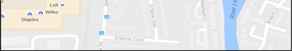
5 Site Location Anthology Hale Works Ltd 4
6 2.0 The Proposals 2.1 Background and Need This EIA process started when Anthology Hale Works Ltd purchased the remaining undeveloped plot of the Hale Village Masterplan The Hale Village masterplan area has been subject to considerable amount of planning over a number of years. Including a series of design competitions and the submission of a reserved matters application for a 20 storey building which remains under consideration by the Council This planning process resulted in the masterplan area being granted outline consent in 2007 with 11 separate blocks, a street network and new public open spaces The Anthology Hale Works site builds upon the wider masterplan for the Hale Village development originally consented in The vision for Hale Village is to create a vibrant, sustainable, high quality, urban village integrated with the surrounding area which will act as a model for other mixed use developments and a catalyst for the regeneration of Tottenham Hale. Since it has become a multi award winning urban village with sustainability and community at its heart The brief for the site can be summarised as: Generate a high quality place that respects the emerging townscape and history of the area; Sit the building sympathetically within the wider context; A sustainable place whose design supports the well-being of the residents and the local community; and Buildings that support the wider masterplan and sets the benchmark for quality for the emerging area. 2.2 Alternative Development Scenarios Given this planning history and the planning and decision making process that was undertaken in order to reach the stage where the Hale Village area was allocated and taken through to a grant of consent, no alternative sites have been considered as part of the development of the proposals Also given the fact that there is an outstanding permission on the site for the development of an 18 storey residential building, it has not been deemed appropriate to consider a do nothing scenario as development will come forward on this portion of land irrespective of the outcome of this proposal A number of alternative scenarios were investigated as part of the design process at the initial stage and these are discussed further in the section below. Alternative Designs Whilst the site is identified by Anthology Hale Works Ltd and LVE as being suitable to accommodate development of this nature, during preparation of the proposal, a series of development scenarios have evolved for the Site that seek to accommodate both the aspirations of the client, LBH, consultees and the general public A series of studies have been undertaken at the Site, the results of which are referenced in the main chapters of the ES. The results of these surveys have been used to refine the masterplan into a position where it could be reviewed and consulted upon. Constraints and Opportunities There are a number of constraints and opportunities for development in Tottenham Hale which were highlighted in the Tottenham Hale District Centre Framework, these include: Buildings with heritage value along Ashley Road; Anthology Hale Works Ltd 5
7 Terrace of Victorian houses along the Hale; The approved Premier Inn development on Station Road; Potential new connections between Chestnut Estate and Tottenham Hale Retail Park and surrounding areas; Improved crossings over the railway line, in particular at Ferry Lane; The need for acoustic mitigation between main roads and the railway line and new homes, especially along Monument Way; Key frontages that can be developed to enhance the area; An emerging high street along Broad Lane; Potential for the creation of new public realm, including an east west green link and a north south pedestrian priority route; Adjoining residential and employment neighbourhoods; Foundation constraints due to the Victoria Line and Crossrail 2; and Key vistas looking out onto the Lee Valley Regional Park and Down Lane Park. 2.3 Design Development Building Footprint The site layout initially had to respond to the surrounding buildings and the constraints of the Victoria line The following page shows the four phases the site boundary went through to arrive at the final footprint of development proposed At the lower levels the podium has been shaped to complete the local street pattern and fulfil the principles of the Hale Village masterplan (graphic 1 and 2) A new public square has been created to the west which links through to Tottenham Hale via a new footbridge (graphic 3). The geometry of the curve of Daneland Walk creates a primary pedestrian route to the new residential lobby (graphic 3) On the upper levels a smaller footprint rationalised for residential layouts has been derived through the consideration of street widths and the location of the Victoria Line beneath (graphic 4). Building Height Tottenham Hale is an area undergoing significant regeneration, the proposal sits within the centre of this and planning policy and conversations with stakeholders suggested that it was suitable for a tall building to form an urban landmark which in turn would help to signify the location of Tottenham Hale Station. Massing The site s massing has been developed in response to feedback from LBH and the neighbouring buildings. As such the building s massing has been developed in four main stages. 1. Podium relates to the commercial area of the adjacent Unite Students and Coppermill Heights. 2. Lower Levels The footprint is larger at the lower levels to accommodate 11 units. Its height relates to Unite Students, stepping up from Coppermill Heights. 3. Upper levels The form reduces to accommodate 8 units and a slimmer more elegant massing. The set back is used to provide communal amenity for residents. 4. Crown Conceptually the top levels are combined to form a crown that celebrates the top of the building. Sunlight and Daylight The design has developed to maximise daylight and sunlight levels in the building, how this has progressed is displayed below. Anthology Hale Works Ltd 6


8 Building Footprint Development 1. Initial Site Boundary 2. Respond to step-in agreement and masterplan principles 3. Streetscape - Create new neighbourhood streets and public realm 4. Residential Footprint Responding to street widths and the Victoria Line Anthology Hale Works Ltd 7


9 Sunlight and Daylight Development 1. Sun Path 2. External Amenity - South and West 3. Internalised Amenity North West and East The site benefits from views over the reservoirs. The majority of homes have been designed to provide external balconies which also mitigate overheating. These homes benefit from internalised amenity. Where required the building, form has been shaped to provide aspect to the north west and avoid single aspect north facing units 4. Daylight Penetration Depth 5. Maximising Aspect The size of the plan has been optimised to maximise opportunities for sunlight and daylight in the apartments whilst also creating a generous lobby at the centre of the plan. The floor plan has been developed to maximise aspects and capitalise on the views out. Larger dual aspect units are located on corners whilst single aspect units are further enhanced through splayed windows to the main living spaces that also sculpt the building form. Anthology Hale Works Ltd 8
10 2.4 Description of the Development The proposals are for a residential led mixed use development comprising the following: New mixed use development ranging from 11 to 33 storeys comprising 1,588 sqm commercial space (flexible A1/A3/A4/B1/D1 uses), 279 residential units including affordable housing, together with roof garden and associated landscaping, the provision of basement car parking, bicycle spaces, associated plant including building maintenance unit and internal refuse storage at Plot SW, Hale Village. Schedule of Development Residential Uses The building will be predominantly residential with 43 of the proposed 279 units being affordable. 28 of the units (10%) will be wheelchair accessible The mix for the private housing has been developed by the client with regard to the design constraints and opportunities and based on an analysis of the local area and with regard to LBH planning policy. The housing mix is as set out in the table below. Residential Mix Overview Percentage of mix Studio (flat) Commercial Uses 1B2P (Flat) 2B3P / 2B4P (Flat) 4% 39% 53% 4% 3B6P (Flat) TOTAL UNITS DENSITY (units / ha) Total The Proposed Development will deliver approximately 1,507m 2 GIA (Gross Internal Area) of space. The proposal for this space is flexible and will deliver a range of A1 / A3 / A4 / B1 / D1 uses spread across the ground floor of the building, overall end use will be dependent on market forces The commercial space is being designed to meet the requirements of BREEAM (2014) Very Good. Building Heights The building proposed will be a range of heights, with a maximum total height of 120m AOD (above ordnance datum), which accounts for all building plant above the top level of residential development At the 11 th storey there is the shoulder of the building which will form a sky garden for use by residents, this will be located at a height of 49m AOD. Basement The basement of the Proposed Development will deliver 36 car parking spaces, including 24 accessible spaces, and four residential and commercial motorcycle spaces. The basement will also provide 448 residential and commercial long stay cycle spaces within five secure storage areas The basement will also provide associated space for plant and a commercial loading bay and moving in day bay. Site Access Arrangements The site is located in an area with a public transport accessibility level (PTAL) rating of 6a indicative of very high accessibility to local public transport services. The Site is located adjacent to the Tottenham Hale Station which has overground and underground lines and a bus interchange Long stay parking for vehicles and cycles is provided in the basement as set out above. Additionally, 34 residential and commercial short stay cycle spaces will be available within the landscape on the ground floor. Anthology Hale Works Ltd 9


11 Landscape and Open Space Proposals The landscape masterplan for the proposals is designed to be simple and coherent and link in to the existing high quality materials and design of the wider Hale Village development The development will provide approximately 1,050m 2 of public realm space. This space improves access to Hale Village and Tottenham Hale Station and creates wide pedestrian streets punctuated by large scale appropriate planters and the provision of 12 new trees The development also provides a sky garden on the 11 th floor, which will provide approximately 200m 2 of open space and play provision. The skygarden will be accessible to all occupiers of the Proposed Development. The skygarden will include planters, timber seating, high quality paving and elements of informal play incorporated within the scheme Additionally, 61m 2 of space adjacent to this will provide residents with a sky lounge providing additional amenity space The podium roof offers the opportunity for a green roof space and therefore will provide approximately 770m 2 of green roof space. This is likely to be in the form of sedum and perennial mix planting; the species will be a mix including perennials to offer height and all yearround interest. Proposed view looking from Ferry Street Anthology Hale Works Ltd 10

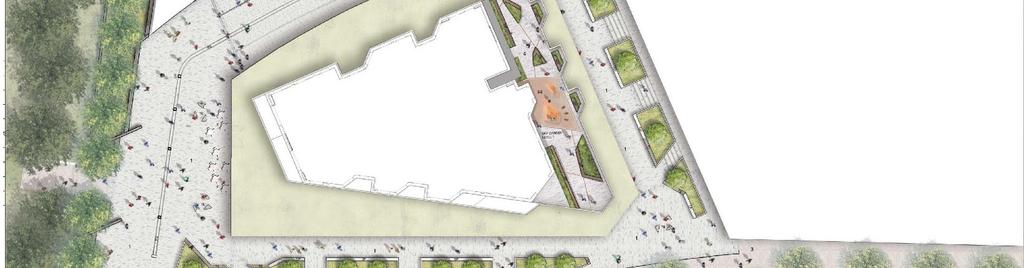
12 Proposed Landscape Masterplan Anthology Hale Works Ltd 11
13 3.0 Consultation 3.1 Approach to Consultation Anthology Hale Works Ltd and their consultants have undertaken extensive discussions with statutory and non-statutory consultees, the local community and landowners The findings have had an influence over the evolution of the design and the scope of the EIA Consultation began at the earliest stage of the development to establish feasibility and has progressed through to the submission of the planning application. This consultation process is summarised across the page The Applicant implemented a comprehensive programme of community engagement which began in November 2016, and included the following: Two Public Exhibitions - The Applicant hosted two separate public exhibitions in the local area. Engagement with Residents Associations and local groups -The Applicant sought to engage with local resident associations including the Ferry Lane Action Group (FLAG) Engagement with local elected representatives Public consultation website - To ensure a continuous flow of information, the Applicant established a consultation website Direct liaison with residents The Applicant ensured that its consultants were available to discuss the plans with residents who wished to be involved in the application process. This included meeting with residents of Coppermill Heights. Anthology Hale Works Ltd 12
Thornton Road, Pickering Environmental Statement Non-Technical Summary. January 2016
 Thornton Road, Pickering Environmental Statement Non-Technical Summary January 2016 EIA Quality This Environmental Statement, and the Environmental Impact Assessment (EIA) carried out to identify the significant
Velindre Cancer Centre Environmental Statement Vol.1: Environmental Statement Text. Chapter 1: Introduction
 Velindre Cancer Centre Environmental Statement Vol.1: Environmental Statement Text Chapter 1: Introduction Draft - March 2017 Prepared by: Address: Email: Website: Mott McDonald, The Urbanists and HLM
Longbridge Town Centre Phase 2 Planning Application
 Longbridge Town Centre Phase 2 Planning Application Non-Technical Summary of the Environmental Statement December 2013 Introduction A full application for Planning Permission has been submitted to Birmingham
Kidbrooke Village Forthcoming Planning Proposals Phases 3, 5 and 6
 July 2014 Kidbrooke Village Forthcoming Planning Proposals Phases 3, 5 and 6 Design Evolution and changes since our last consultation This document outlines how the feedback received from our last consultation
Armourers Court, Woolwich
 Armourers Court, Woolwich Environmental Statement, Non-Technical Summary December 2013 DESIGN PACKAGE C158 WOOLWICH STATION East End Over Site Development (Armourers Court, Arsenal Way, Woolwich) Environmental
Anston House, Brighton
 Anston House, Brighton Welcome to our Anston House community consultation event Welcome to our first public consultation event regarding Anston House, Brighton. The site has been acquired by One Preston
Welcome. Welcome to the second public exhibition hosted by Argent Related. Today s exhibition: Consultation so far: Have your say.
 CHESNUT CHESTNUT HIGH CROSS THE BUS B LANE 5 1 METRES Map showing Argent Related sites Welcome Welcome to the second public exhibition hosted by Argent Related. Argent Related is proposing to redevelop
Cardiff International Sports Village Waterfront Development Volume IV : Non-Technical Summary of the Environmental Statement
 Greenbank Partnerships Ltd October 2012 Cardiff International Sports Village Waterfront Development Volume IV : Non-Technical Summary of the Environmental Statement Environmental Statement - Non Technical
NORTH CIRCULAR ROAD - REGENERATION IN ACTION
 NORTH CIRCULAR ROAD - REGENERATION IN ACTION Notting Hill Housing is a social enterprise which has been at the forefront of vibrant urban regeneration since 1963. Notting Hill has over 25,000 homes across
HS2 Interchange Station Design
 Working on behalf of HS2 Interchange Station Design October 2018 www.hs2.org.uk 1 Interchange Station, Solihull Introduction In February 2018, HS2 Ltd appointed Arup to take forward the design of Interchange
Stoke Newington High Street 1.0 Site Analysis
 1.0 Site Analysis 9-11 Stoke Newington Church Street Grade II Existing Entrance via Wilmer Place Stoke Newington Church Street 187-191, 18th C; Grade II* including forecourt wall, railings and gates Rights
GREENWICH PENINSULA CABLE CAR AREA MASTERPLAN ENVIRONMENTAL STATEMENT NON-TECHNICAL SUMMARY. 24 December 2010
 GREENWICH PENINSULA CABLE CAR AREA MASTERPLAN ENVIRONMENTAL STATEMENT NON-TECHNICAL SUMMARY 24 December 2010 Our Ref: DT/JLL0509 Appeal Ref (optional): RPS 1 st Floor West Cottons Centre Cottons Lane London
Application Guide. Should you have any questions on the Outline Application please contact:
 Application Guide Application Guide This guide describes the structure of the Outline Application, explains the different documents that have been submitted with it and identifies what will happen next.
Chapter 2: OUTLINE PLANNING APPLICATION PROPOSALS. A New Garden Neighbourhood Matford Barton 17
 Chapter 2: OUTLINE PLANNING APPLICATION PROPOSALS A New Garden Neighbourhood Matford Barton 17 2.1. SUMMARY AND STATUS OF THE PROPOSALS 2.1.1. The parameter plans and associated wording in this chapter
Unity Square, Nottingham Environmental Statement Non Technical Summary December 2013
 Unity Square, Nottingham Environmental Statement Non Technical Summary December 2013 in association with 1. Introduction Peel Holdings is applying to Nottingham City Council (NCC) for Outline planning
Public Consultation. Land at Monks Farm, North Grove. Welcome
 Welcome Welcome to our public exhibition for development on Land at Monks Farm, orth Grove. Gallagher Estates and Gleeson Strategic Land are preparing an outline planning application for new homes, open
Replacement Golf Course Facilities and Residential Development, Churston. Environmental Statement Non-Technical Summary
 Replacement Golf Course Facilities and Residential Development, Churston Environmental Statement Non-Technical Summary July 2011 Reproduced from the Ordnance Survey s map with the permission of the Controller
16. Peckham Peckham Area Vision
 16. 16.1. Area Vision 16.1.1. is: A lively town centre providing a range of daytime and night time activities on Rye Lane including a Library, a Leisure Centre and many independent retailers which specialise
Former Temple Cowley Pools, Oxford TEMPLE COWLEY LIBRARY * ELEVATION SHOWN IS INDICATIVE AND SUBJECT TO FINAL DESIGN AND AGREEMENT.
 OPEN SPACE TEMPLE COWLEY LIBRARY library beyond Proposed apartments Proposed apartments Proposed houses Temple Road * ELEVATION SHOWN IS INDICATIVE AND SUBJECT TO FINAL DESIGN AND AGREEMENT. * Welcome
BRIDGE OF DON MASTERPLAN & PLANNING SUMMARY
 BRIDGE OF DON MASTERPLAN & PLANNING SUMMARY SITE LOCATION The site of the existing AECC lies in an area of predominately residential and business use in Bridge of Don and extends approximately 50 acres.
BEAUFORT PARK BUILDINGS D3 TO D8 PLANNING APPLICATION ENVIRONMENTAL STATEMENT NON- TECHNICAL SUMMARY
 BEAUFORT PARK BUILDINGS D3 TO D8 PLANNING APPLICATION ENVIRONMENTAL STATEMENT NON- TECHNICAL SUMMARY November 2014 Introduction 1.1 St George Central London (the Applicant ) is seeking to obtain planning
17A. Wind Microclimate
 17A. Wind Microclimate 17A.1 Introduction 17A.1.1 17A.1.2 17A.1.3 17A.1.4 This Chapter, which has been prepared by Waterman and BMT, provides further information with regard to the potential wind microclimate
5. Bankside and The Borough 5.1. Bankside and The Borough Area Vision
 5. 5.1. Area Vision 5.1.1. are: A globally significant central London business district which is home to international business headquarters; At the heart of the commercial and cultural life of the capital
Welcome to our public exhibition on London Square s plans to redevelop the B&Q site on Smugglers Way. from Monday 10th October 2016.
 WELCOME Welcome to our public exhibition on London Square s plans to redevelop the B&Q site on Smugglers Way. Aerial view of existing site Our plans are for a mixed use development which will provide new
PDP DESIGN & ACCESS STATEMENT
 PDP The Planning & Design Partnership Planning.. Architecture.. Interiors.. Landscape The Chicory Barn Studio, The Old Brickyards, Moor Lane, Stamford Bridge York, The East Riding Of Yorkshire, YO41 1HU.
Former North Works, Lickey Road, Longbridge, Birmingham
 Committee Date: 14/11/2013 Application Number: 2013/06431/PA Accepted: 27/08/2013 Application Type: Full Planning Target Date: 26/11/2013 Ward: Longbridge Former North Works, Lickey Road, Longbridge, Birmingham
Environmental Impact Assessment
 Environmental Impact Assessment Environmental impact assessment (EIA) is the process of systematically drawing together an assessment of the likely significant environmental effects of a development project.
Welcome to our exhibition
 Welcome to our exhibition housing development A46 Wildmoor Alcester Road Canal Quarter A422 Town Centre housing development Warwickshire-based IM Properties, one of the UK s largest privately owned property
Neighbourhood Planning Local Green Spaces
 Neighbourhood Planning Local Green Spaces Introduction... 2 1. Why green space is important... 4 2. Neighbourhood plans and green space... 6 3. Evidence... 8 Statutory designations... 9 Green space audit...
Derry City and Strabane District Council Planning Committee Report
 Derry City and Strabane District Council Planning Committee Report COMMITTEE DATE: 23 rd March 2016 APPLICATION No: APPLICATION TYPE: PROPOSAL: LOCATION: APPLICANT: LA11/2015/0395/F Residential Development
Tall Buildings Strategy
 Chapter 8 Tall Building Strategy Mayor of London 115 existing & consented tall buildings effect on views of palace of westminster Chapter 8 Tall Buildings Strategy tall building cluster upto 150m with
Perth and Kinross Council Development Management Committee 8 June Pre-Application Report by Development Quality Manager
 Perth and Kinross Council Development Management Committee 8 June 2016 5(3)(i) 16/259 Pre-Application Report by Development Quality Manager Residential development at St Martins Road, Land 120 metres West
RE: THE MALL, WALTHAMSTOW PLANNING APPLICATION REF: 17/1355 RESPONSE TO LBWF NEIGHBOUR CONSULTATION
 Gavin Chinniah Planning Manager Majors Team Development Management London Borough of Waltham Forest Sycamore House Town Hall Complex Forest Road London E17 4JF 19278/A3/RM/MJ/sl 4 th October 2017 Dear
Welcome THE SITE PHASE 1 EXCLUSION ZONE.
 THE SITE PHASE 1 Aerial view of the whole site with Phase 1 indictated Welcome Barratt London and Hyde Group are working with Pollard Thomas Edwards on redevelopment proposals for Harrow View East, part
Welcome to the Queen s Square, Croydon Consultation
 Welcome to the Queen s Square, Croydon Consultation 02 PARK STREET 1-27 ST GEORGE S WALK 03 05 04 06 01 Croydon Town Hall The Queen s Gardens Thank you for coming to the public consultation about our proposed
Statement of Community Involvement LAND OFF SOUTHDOWN ROAD HORNDEAN, HAMPSHIRE
 LAND OFF SOUTHDOWN ROAD HORNDEAN, HAMPSHIRE CONTENTS Page 1. Introduction 3 2. Pre-application Discussions 4 3. The Consultation Process 5 4. Consultation Feedback 7 5. Responses to Consultation Feedback
75-89 Wallis Road & 59 Berkshire Road, Hackney Wick, London, E9 5LN
 East London Mixed-Use Development Opportunity CGI of Proposed Scheme Summary A mixed-use development opportunity located in Hackney Wick within the jurisdiction of the London Legacy Development Corporation.
LONDON BOROUGH OF WALTHAM FOREST. The Mall, 45 Selborne Road, Walthamstow, London
 LONDON BOROUGH OF WALTHAM FOREST Committee / Date: Planning - 13 th December 2017 Application Reference: 171355 Applicant: Location: Proposed development: Wards affected: Selborne One Limited and Selborne
INTRODUCTION NORTH HEYBRIDGE GARDEN SUBURB
 INTRODUCTION This event is being hosted by the promoters of the proposed North Heybridge Garden Suburb who are working with Maldon District Council and other key stakeholders on the preparation of a comprehensive
Development of land adjacent to Braggs Farm Lane and Rumbush Lane, Dickens Heath. Welcome. Today s exhibition. The proposal site
 Welcome Welcome to this event to discuss the development of land adjacent to Braggs Farm Lane. is currently in the preliminary stages of designing proposals to sensitively develop this site with high-quality
1.0 Purpose of a Secondary Plan for the Masonville Transit Village
 Report to Planning and Environment Committee To: Chair and Members Planning & Environment Committee From: John M. Fleming Managing Director, Planning and City Planner Subject: Masonville Transit Village
Linden Homes Proposals for land off Ringwood Road, Verwood
 Welcome Welcome to Linden Homes first public exhibition displaying proposals for new homes on land off Ringwood Road in Verwood. Award-winning house builder Linden Homes, part of the Galliford Try Group,
Chapter 4. Route Window C12: Mile End Park and Eleanor Street Shafts
 Chapter 4 Route Window C12: Mile End Park and Eleanor Street Shafts 48 Crossrail Amendment of Provisions 4 Route Window C12: Mile End Park and Eleanor Street Shafts Location plan of Mile End Park and Eleanor
Cotswolds AONB Landscape Strategy and Guidelines. June 2016
 Cotswolds AONB Landscape Strategy and Guidelines June 2016 Cotswolds AONB Landscape Strategy and Guidelines Introduction The evolution of the landscape of the Cotswolds AONB is a result of the interaction
Newcourt Masterplan. November Exeter Local Development Framework
 Newcourt Masterplan November 2010 Exeter Local Development Framework Background The Exeter Core Strategy Proposed Submission sets out the vision, objectives and strategy for the development of Exeter up
THE WHARVES DEPTFORD STATEMENT OF COMMUNITY INVOLVEMENT EXECUTIVE SUMMARY. May 2015 MOVING FORWARD
 THE WHARVES DEPTFORD MOVING FORWARD THE WHARVES DEPTFORD STATEMENT OF COMMUNITY INVOLVEMENT EXECUTIVE SUMMARY May 2015 2 The Wharves Deptford Statement of Community Involvement The Wharves Deptford Statement
Peckham Peckham Area Vision Map
 Area Vision Map PNAAP13 PNAAP8 Sumner Road Surrey Canal Walk Bird in Bush Park Key: NSP Site Allocations PNAAP Allocations Greenspace Low Line Cycle Network Primary Shopping Areas Square Surrey Canal Walk
Plots L4 & L5 Marchwood Industrial Park Presentation to Marchwood Parish Council 27 th February 2017
 Plots L4 & L5 Marchwood Industrial Park Presentation to Marchwood Parish Council 27 th February 2017 The team presenting to you tonight are: Sam Baggley Group Container Sales Manager, Pentalver Transport
Aylesbury Estate, Southwark. Notting Hill Housing Trust. Planning Statement Revised February 2015
 Aylesbury Estate, Southwark Notting Hill Housing Trust Planning Statement Revised February 2015 Planning Statement / February 2015 / Deloitte Real Estate Contents 1 Introduction 1 2 Aylesbury Estate Site
Introduction to MP3. MP3 H4 Park Central (North)
") MP H4 Park Central (North) Introduction to MP A visualisation of the Illustrative Masterplan with MP shaded in blue MP is the third phase of the Elephant Park regeneration and is bounded by on the north,
MP H4 Park Central (North) Introduction to MP A visualisation of the Illustrative Masterplan with MP shaded in blue MP is the third phase of the Elephant Park regeneration and is bounded by on the north,
Land Adj. 63 Sunny Bank Road, Sutton Coldfield, Birmingham, B73 5RJ
 Committee Date: 11/07/2013 Application Number: 2013/03520/PA Accepted: 20/05/2013 Application Type: Full Planning Target Date: 15/07/2013 Ward: Sutton Vesey Land Adj. 63 Sunny Bank Road, Sutton Coldfield,
Land at Cardigan Street / Belmont Row / Gopsal Street, Eastside, Birmingham, B4 7RJ
 Committee Date: 02/10/2014 Application Number: 2014/05637/PA Accepted: 07/08/2014 Application Type: Full Planning Target Date: 02/10/2014 Ward: Nechells Land at Cardigan Street / Belmont Row / Gopsal Street,
Proposed Mixed-Use Development at Barking Road, Newham, London. Design & Access Statement. March 2013
 Proposed Mixed-Use Development at 110-114 Barking Road, Newham, London Design & Access Statement March 2013 Stephen Davy Peter Smith Architects Ltd Fanshaw House, Fanshaw Street, London N1 6HX Company
SITE ANALYSIS CALVARY HOSPITAL NORTH ADELAIDE LARGE INSTITUTIONS AND COLLEGES DPA CALVARY HOSPITAL
 SITE ANALYSIS Located at: 81-100 Strangways Terrace 55-79 Barnard Street 2-34 Hill Street 312-320 Ward Street HISTORY The Calvary Hospital was established in 1900 and is one of Adelaide's oldest hospitals.
1 INTRODUCTION 1.1 INTRODUCTION
 1 INTRODUCTION 1.1 INTRODUCTION RREEF (UK) Ltd in partnership with Sheffield City Council (SCC) is applying for planning permission for the construction of: a new indoor city centre market hall and indoor
INTRODUCTION. Welcome to the third round of information events on the emerging Yorkshire Energy Park proposals. THE CONSULTANT TEAM WHERE IS THE SITE?
 1 INTRODUCTION Welcome to the third round of information events on the emerging Yorkshire Energy Park proposals. This is the third round of information events that we have undertaken on the project, following
WELCOME GYPSY LANE. Wider Site Location plan. Proposals for the development of LAND OFF FOXLYDIATE LANE WEBHEATH. Proposals for the development of
 WELCOME The developers are preparing an outline planning application for a residential led development and need the community s views in order to develop the proposals further WHAT IS PROPOSED? A high
Land at Rampton Road. Cottenham
 Land at Rampton Road Cottenham Introduction TEP is preparing an outline planning application for 54 dwellings on 6.9 hectares of land adjacent to Rampton Road, Cottenham on behalf of the owners Cambridgeshire
 CGI looking up Market Street towards the Church of Christ the Saviour Welcome St George would like to welcome you to our public exhibition about the progress made at Dickens Yard and our future plans.
4 RESIDENTIAL ZONE. 4.1 Background
 4 RESIDENTIAL ZONE 4.1 Background The residential areas within the City are characterised by mainly lowrise dwellings sited on individual allotments. Past architectural styles, settlement patterns and
97 Lea Bridge Road, Leyton, E10 7QL London Borough of Waltham Forest December 2015
 97 Lea Bridge Road, Leyton, E10 7QL London Borough of Waltham Forest December 2015 Public Realm and Landscape Proposals LEA BRIDGE ROAD, WALTHAMSTOW Public Realm & Landscape Proposals BDP(90)RPT001 December
WELCOME. Welcome to our second public exhibition on proposals for the redevelopment of the Paddington Central Management Office.
 WELCOME Management Office Paddington Central Welcome to our second public exhibition on proposals for the redevelopment of the Paddington Central Management Office. Following feedback from meetings with
design & access statement Proposed Erection of 68 Bedroom Hotel and Restaurant with Associated Landscaping
 Proposed Erection of 68 Bedroom Hotel and Restaurant with Associated Landscaping Promenade, design & access statement lawrencemcphersonassociates 6 new road, ayr, ka8 8ex On Behalf of July 2015 CONTENTS
6. Bermondsey 6.1. Bermondsey Area Vision
 6. 6.1. Area Vision 6.1.1. is: An inner-london neighbourhood characterised by modest worker ho associated with the historic Rotherhithe docks and local manufacturing industries such as biscuits, jam, vinegar
DEFGH. Crystal Place Park. Environmental Impact Assessment (EIA) Elin Thomas and Emily Low Waterman Environmental
 Elin Thomas and Emily Low Waterman Environmental") DEFGH Crystal Place Park Environmental Impact Assessment (EIA) Elin Thomas and Emily Low Waterman Environmental 10.12.07 EIA Presentation Content What is EIA? Legal Requirements Process Q&A Key Topics
DEFGH Crystal Place Park Environmental Impact Assessment (EIA) Elin Thomas and Emily Low Waterman Environmental 10.12.07 EIA Presentation Content What is EIA? Legal Requirements Process Q&A Key Topics
WELCOME MEET THE TEAM TIMESCALES. Thank you for attending our first public exhibition which showcases Anthology s early development ideas.
 WELCOME Thank you for attending our first public exhibition which showcases Anthology s early development ideas. This follows on from the Meet and Greet events held in July, which invited the local community
Proposals for a new college and homes. Thank you for visiting our exhibition.
 1 Welcome Thank you for visiting our exhibition. The college are pleased to welcome you to view our plans to regenerate. If you have any questions, please feel free to speak with a member of the project
LEWISHAM RETAIL PARK WELCOME
 WELCOME Welcome to the public exhibition on the initial proposals for the redevelopment of Lewisham Retail Park in Lewisham Town Centre. Legal & General own Lewisham Retail Park and are in discussions
I615. Westgate Precinct
 I615. Westgate Precinct I615.1. Precinct Description The Westgate Precinct is located approximately 18km west of the Auckland city centre. There are seven Sub-precincts in the Westgate Precinct: Sub-precinct
SUBJECT: Waterfront Hotel Planning Study Update TO: Planning and Development Committee FROM: Department of City Building. Recommendation: Purpose:
 Page 1 of Report PB-23-18 SUBJECT: Waterfront Hotel Planning Study Update TO: Planning and Development Committee FROM: Department of City Building Report Number: PB-23-18 Wards Affected: 2 File Numbers:
ROCHFORD LOCAL DEVELOPMENT FRAMEWORK: Sustainability Appraisal/ Strategic Environmental Assessment. Rochford Core Strategy Preferred Options Document
 ROCHFORD LOCAL DEVELOPMENT FRAMEWORK: Sustainability Appraisal/ Strategic Environmental Assessment Non Technical Summary Rochford Core Strategy Preferred Options Document October 2008 SUSTAINABILITY APPRAISAL
Welcome to our exhibition
 Welcome to our exhibition The Homes & Communities Agency (HCA) welcomes you to this public exhibition explaining our proposals for the redevelopment of the former Lea Castle Hospital site. About the Homes
WHITELEY TOWN COUNCIL NORTH WHITELEY DEVELOPMENT SEPTEMBER 2014
 WHITELEY TOWN COUNCIL NORTH WHITELEY DEVELOPMENT SEPTEMBER 2014 Dear Resident This Special Edition of the Whiteley Voice which has been prepared in conjunction with the North Whiteley Consortium is to
PLANNING STATEMENT. Market House Market Place Kingston upon Thames KT1 1JS
 PLANNING STATEMENT To support planning and listed building consent applications for change of use from Class A1 shop and Class A3 cafe to Class A3 restaurant at: Market House Market Place Kingston upon
Welcome to the Ashley Road South Consultation Event!
 Welcome to the Ashley Road South Consultation Event! Ashley Road South will be a place that inspires people. It is aspirational, and has the potential to be one of the best development sites in north London.
South Quay Plaza Tower Hamlets Community Forum; Record of Discussion
 South Quay Plaza Tower Hamlets Community Forum; 03.02.14 Record of Discussion Attendees: Jerry Bell - Tower Hamlets Council Nasser Farooq - Tower Hamlets Council Emily Harris - Berkeley Homes (South East
WELCOME. Land North of STEVENAGE. We would like to thank you for attending our public exhibition today.
 WELCOME We would like to thank you for attending our public exhibition today. The purpose of this event is to share our proposals and hear your thoughts on our ideas. Members of the project team are on
Page 1 of 19 URBAN DESIGN FRAMEWORK FOR BOLTON STREET WATERFORD
 Page 1 of 19 URBAN DESIGN FRAMEWORK FOR BOLTON STREET WATERFORD 1.0 Introduction: The relocation of the City Council stores and depot from Bolton Street creates an exciting opportunity for development
Linden Homes Proposals for the Ridgewood Centre, Old Bisley Road, Frimley
 Linden Homes Welcome Welcome to our public exhibition. Today we are displaying draft proposals for a high quality residential redevelopment of land off Old Bisley Road, currently known as the Ridgewood
11. ISLINGTON ROUTE SECTION ENVIRONMENTAL BASELINE AND ASSESSMENT OF IMPACTS OVERVIEW OF ISLINGTON ROUTE SECTION... 2
 11. ISLINGTON ROUTE SECTION ENVIRONMENTAL BASELINE AND ASSESSMENT OF IMPACTS... 2 11.1 OVERVIEW OF ISLINGTON ROUTE SECTION... 2 11.2 POLICIES RELEVANT TO ALL WORKSITES IN ISLINGTON... 3 11.3 FARRINGDON
WELCOME TO THE NEW WILTON PARK
 WELCOME TO THE NEW WILTON PARK VISION HISTORY OF WILTON PARK TOWARDS A PLANNING APPLICATION Our objective is to create a truly outstanding environment at Wilton Park. At the heart of our proposals is a
Hengrove Park Phase 1. BUDF Briefing. Kier Living. Stride Treglown job no Prepared by Checked by Date January 2017 Revision -
 Hengrove Park Phase 1 BUDF Briefing Kier Living Stride Treglown job no. 32507 Prepared by ACR Checked by RD Date January 2017 Revision - Revisions Revision Rev A Description Description of revision(s).
Peter Brett Associates LLP (PBA) act on behalf of db symmetry ltd in respect of the proposed symmetry park, Kettering development (the Site).
 act on behalf of db symmetry ltd in respect of the proposed symmetry park, Kettering development (the Site).") Our ref: 30062 2 nd August 2017 Kettering Borough Council Planning Department Municipal Offices Bowling Green Rd Kettering NN15 7QX 61 Oxford Street Manchester M1 6EQ T: +44 (0)161 245 8900 E: manchester@peterbrett.com
Our ref: 30062 2 nd August 2017 Kettering Borough Council Planning Department Municipal Offices Bowling Green Rd Kettering NN15 7QX 61 Oxford Street Manchester M1 6EQ T: +44 (0)161 245 8900 E: manchester@peterbrett.com
Date: TOWN AND COUNTRY PLANNING (ENVIRONMENTAL IMPACT ASSESSMENT) REGULATIONS 2011: REGULATION 13 SCOPING OPINION
 REGULATIONS 2011: REGULATION 13 SCOPING OPINION") PLANNING & BUILDING CONTROL Tracy Harvey Head of Planning & Building Control Rob Wells Savills Innovation Court 121 Edmund Street Birmingham B3 2HJ Our Ref: 5/16/3441 E-mail: Date: planning@stalbans.gov.uk
PLANNING & BUILDING CONTROL Tracy Harvey Head of Planning & Building Control Rob Wells Savills Innovation Court 121 Edmund Street Birmingham B3 2HJ Our Ref: 5/16/3441 E-mail: Date: planning@stalbans.gov.uk
GREENFORD HALL & ADJOINING LAND
 GREENFORD HALL & ADJOINING LAND CONTENTS 1. Introduction 1. Introduction 2. Urban Context 2.1 The Site and Surroundings 2.2 Urban Context Map 2.3 Access and Movement 3. Planning Context 3.1 Planning History
LDF. Local Development Framework. Manor House Area Action Plan. Adopted January 2013 PJ50811
 LDF Local Development Framework Manor House Area Action Plan Adopted January 2013 PJ50811 CONTENTS PART A Introduction, Baseline and Options 1. Introduction 4 1.1. Why prepare an Area Action Plan? 4 1.2.
8. Camberwell 8.1. Camberwell Area Vision
 8. 8.1. Area Vision 8.1.1. is: Centred on a medieval village centre which has become a thriving modern town centre surrounded by residential streets laid out in the Georgian era; Linked by rail to central
Welcome! Joyce Avenue & Snell s Park Estate Regeneration. Please make sure that you fill out our feedback form after you have seen the exhibition!
 Welcome! As part of its Housing Development and Estate Renewal Improvement Programme, the Council is currently consulting with you on the long term future of your estates at Joyce Avenue and Snell s Park.
DISTRIBUTION OF MASS / ARTICULATION TALLER BUILDINGS LOCATION ORIENTATED TO MINIMISE OVERSHADOWING TO PUBLIC AMENITY SPACES.
 DISTRIBUTION OF MASS / ARTICULATION TALLER BUILDINGS LOCATION ORIENTATED TO MINIMISE OVERSHADOWING TO PUBLIC AMENITY SPACES. - HEIGHT USED TO MARK DESTINATION - MINIMISE OVERSHADOWING. - CREATE RHYTHMIC
Welcome. Walk Around. Talk to Us. Write Down Your Comments
 Welcome This is an information meeting introducing the applications for proposed redevelopment of the Yorkdale Shopping Centre site at 3401 Dufferin Street and 1 Yorkdale Road over the next 20+ years,
Welcome to our public exhibition
 About Our Scheme Welcome to our public exhibition This exhibition gives you the chance to view and comment upon our emerging proposals for a new residential development of 68 new homes on the site of the
Vision for East Cowes
 Vision for East Cowes A better East Cowes for now and the future The East Cowes Regeneration project is a major regeneration scheme on the Isle of Wight. It will create a vibrant community with a long-term
WELCOME. We are interested in your ideas and feedback, so please fill out one of our feedback forms.
 WELCOME WE ARE PLEASED TO PRESENT OUR LATEST PROPOSALS FOR A NEW AND ENHANCED WALTHAMSTOW TOWN CENTRE The purpose of this exhibition is to update you on how the scheme has been developed, incorporating
DESIGN & ACCESS STATEMENT. REVISION A Residential Development, Neon Social Club, Nairn Street, Jarrow.
 DESIGN & ACCESS STATEMENT. REVISION A Residential Development, Neon Social Club, Nairn Street, Jarrow. The following Design & Access Statement is in support of a Full Planning Application for a residential
THE STORY SO FAR... THE STORY SO FAR...
 THE STORY SO FAR... Levitt Bernstein architects Levitt Bernstein are award winning architects who have designed many successful retail and residential projects. We are specialists in working with local
10. East Dulwich East Dulwich Area Vision
 10. 10.1. Area Vision 10.1.1. is: A predominantly residential area characterised by mostly medium density housing, including many family homes. Many parts of have retained historic character and it includes
Description Details submitted pursuant to discharge of condition 5 (Design Code) attached to planning permission 13/01729/OUT.
 attached to planning permission 13/01729/OUT.") ITEM 9 Application Number: 18/00266/DISCON Description Details submitted pursuant to discharge of condition 5 (Design Code) attached to planning permission 13/01729/OUT. AT The Point, 602 Midsummer Boulevard,
ITEM 9 Application Number: 18/00266/DISCON Description Details submitted pursuant to discharge of condition 5 (Design Code) attached to planning permission 13/01729/OUT. AT The Point, 602 Midsummer Boulevard,
NON-TECHNICAL SUMMARY. October 2017 CLARENDON GAS WORKS WOOD GREEN
 NON-TECHNICAL SUMMARY October 2017 CLARENDON GAS WORKS WOOD GREEN CLARENDON GAS WORKS, HARINGEY ENVIRONMENTAL STATEMENT NON-TECHNICAL SUMMARY October 2017 Our Ref: Q70251 Contents 1 INTRODUCTION... 2 2
Euston Area Plan - Examination: Statement in response to the Inspector s Matters, Issues and Questions
 1 Euston Area Plan - Examination: Statement in response to the Inspector s Matters, Issues and Questions Sydney and London Properties Limited June 2014 2 3 This document is the Statement in response to
Camberwell Camberwell Area Vision Map
 Area Vision Map NSP23 Burgess Park Edmund Street NSP29 NSP30 NSP31 New Road Benhill Road NSP27 NSP33 Green Brunswick Park NSP22 station NSP24 Peckham Road NSP26 St Giles Church Lucas Gardens NSP28 NSP25