MIDTOWN. White River 38TH STREET (MAPLE ROAD) G u i d i n g P r i n c i p l e s & F u t u r e D e v e l o p m e n t S t r a t e g i e s
|
|
|
- Ira Johnston
- 5 years ago
- Views:
Transcription
1 MIDTOWN INDIANAPOLIS White River NORTH MERIDIAN STREET 38TH STREET (MAPLE ROAD) Fall Creek G u i d i n g P r i n c i p l e s & F u t u r e D e v e l o p m e n t S t r a t e g i e s A Working Planning Document Commissioned by the: Historic Midtown Inititative (HARMONI) Maple Road Development Association (MRDA) SPRING 2010


2 H I S T O R I C M O D E R N D Y N A M I C COMFORTABLE COLLABORATIVE S P I R I T E D I M P R E S S I V E M I D T O W N I N D Y IN ONE PLACE


3 MIDTOWN INDIANAPOLIS G u i d i n g P r i n c i p l e s & F u t u r e D e v e l o p m e n t S t r a t e g i e s This is a unique initiative. The Midtown District is a destination.a valuable economic and cultural asset to the City of Indianapolis, in addition to serving as home to approximately 40,000 residents and many of the City s most venerable institutions of culture and learning. This document is a collection of strategies to provide Midtown residents an excellent modern urban lifestyle in the midst of charming, historic neighborhoods. Additionally, the intent is to illustrate the need for future investment to City policy leaders and those interested in being a part of the Midtown family. Through action on the principles and strategies of this document, stakeholders will return this district to the walkable, bikeable, connected condition it was expertly designed to be nearly 100 years ago. For the first half of the 1900s, North Meridian Street and surrounding boulevards served as an impressive gateway into Indianapolis and Midtown was home for many dignitaries who lived in stately residences. The neighborhoods were peppered with prosperous business corners, shops and restaurants. But after the 1960s flight to the suburbs, the area settled into the backdrop of Indianapolis as a busy commuter thoroughfare. Midtown was badly stressed by high speed traffic and challenging economic conditions for businesses and property owners. With significant community support AND strategic public policy and private sector investment, Midtown will exceed its original condition as an exceptional place to live in Indianapolis. The goal is to rejuvenate these attractive neighborhoods and revive business areas corner by corner, block by block until the entire Midtown area is thriving and sustainable. This is our story. Mapleton-Fall Creek Development Corporation

 ASSESSED VALUE: Approx. $3 Billion Dollars 2007 Assessment (Approx.")
 BROAD RIPPLE VILLAGE 62ND STREET GLENDALE TOWN CENTER MICHIGAN ROAD MARIAN UNIVERSITY INDIANAPOLIS MUSEUM OF ART CHRISTIAN THEOLOGICAL")

4 MONON TRAIL Where is? BY THE NUMBERS INDIANAPOLIS ART CENTER TOTAL SIZE: 8-10 Square Miles (Traditional Downtown Indianapolis is one square mile. The Regional Center is 6.5 sq.mi.) POPULATION: Approx. 40,000 residents 18,200 Households (2009 Projection from 2000 Census) ASSESSED VALUE: Approx. $3 Billion Dollars 2007 Assessment (Approx. 5% of Marion County Total Assessed Value on approximately 2% of Marion County Land Area.) BROAD RIPPLE VILLAGE 62ND STREET GLENDALE TOWN CENTER MICHIGAN ROAD MARIAN UNIVERSITY INDIANAPOLIS MUSEUM OF ART CHRISTIAN THEOLOGICAL SEMINARY THE WHITE RIVER CLOWES HALL BUTLER UNIVERSITY NORTH MERIDIAN STREET HINKLE FIELDHOUSE MIDTOWN 38TH STREET CENTRAL CANAL TOWPATH NORTH MERIDIAN STREET HISTORIC DISTRICT NORTH COLLEGE AVENUE INDIANA SCHOOL FOR THE DEAF INDIANA STATE FAIRGROUNDS KESSLER BOULEVARD FALL CREEK BOULEVARD DEMOGRAPHIC ANALYSIS BOUNDARY KEYSTONE BOULEVARD CROWN HILL CEMETERY DEMOGRAPHIC ANALYSIS BOUNDARY INTERSTATE 65 CHILDRENʼS MUSEUM OF INDIANAPOLIS 30TH STREET FALL CREEK IVY TECH COMMUNITY COLLEGE MIDTOWN TO DOWNTOWN INDIANAPOLIS 4 Guiding Principles & Future Development Strategies


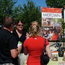
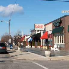
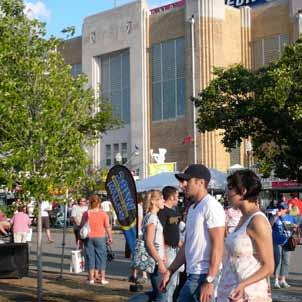
5 Here s what Midtown looks like to a visitor... AMAZING DESTINATIONS & NEIGHBORHOODS. Indianapolis Art Center and ArtsPark Multiple Neighborhood Commercial Village Centers The North Meridian Street Historic District The Monon Trail and Greenway The White River The Indiana State Fairgrounds The Indianapolis Museum of Art MIDTOWN is a district where the best of art, sports, culture, education, nightlife and village-living converge in the natural landscape of Indianapolis. The Children s Museum of Indianapolis Broad Ripple Village Marian University Christian Theological Seminary Clowes Memorial Butler University Butler University Hinkle Fieldhouse Crown Hill Cemetery The Central Canal Towpath IVY Tech Community College Guiding Principles & Future Development Strategies 5
6 Let s look at Midtown over the last 20 years... A DEMOGRAPHIC SNAPSHOT Indianapolis Popula-on Households Families Average Household Size Vacancy Rate Midtown Popula-on Households Families Average Household Size Vacancy Rate Midtown Capture of total Indianapolis Popula-on Sources: ESRI Market Report, US Census Bureau % Change 731, , , % 46,918 19,306 11, % 794, , , % 40,772 18,200 8, % 9% 11% 1% 2% 68% 13% 6% 26% 9% 87% 6.4% 5.1% 20% Population decline and increased vacancy have reduced Midtown s share of the total Indianapolis population by 20% in almost 20 years. 20,000 Total Change in the Number of Families, ,000 10,000 5,000 0 Since 1990, Midtown has lost over 2,000 households with school- age children. Midtown Zionsville Brownsburg Greenwood Carmel Indianapolis Fishers 2 Person Households 32.50% 3 Person Households 14.20% 1 Person Households 38.20% 4+ Person Households 15.10% Singles and couples comprise the vast majority of Midtown households. Median Household Income $120,000 $100,000 $80,000 $60,000 $40,000 $20,000 Midtown s median household income is well below area suburban communities and only slightly higher than Marion County as a whole. $44,830 $48,675 $48,792 $55,672 $57,734 $83,498 $91,797 $96,215 $102,238 Percent of Population 25+ Who Attended College 90% 80% 70% 60% 50% 40% 30% 20% 10% 63.7% 69.1% 86.4% 86.8% 6 $0 Indianapolis Indiana Marion County Guiding Principles & Future Development Strategies Midtown Greenwood Avon Fishers Carmel Zionsville 0% Zionsville Midtown Fishers Carmel Midtown has almost 70% of its population above the age of 25 that has attended at least some college.


7 Here s what Midtown looks like to concerned residents... LACK OF CONTINUING PUBLIC INVESTMENT Unmanaged Traffic Congestion in Commercial Districts Declining Residential Housing Stock Unsafe Routes to School for Children Crumbling Infrastructure and Bridges Poor Architecture that does not Contribute to Character Drainage and Stormwater Management Issues Uninspiring Public Parks Despite the tremendous residential, commercial and cultural assets of MIDTOWN, there are real threats to the value of this district and to the entire City of Indianapolis. Non-standard and Unsafe Sidewalks Broken Infrastructure and Public Right of Way Traffic Moving at Unsafe Speeds on Residential Streets Increasing commuter-oriented signage Vandalization of Vacant Properties Increase in poorly managed rental properties Vacant Commercial Structures Aging Roadway Infrastructure with no sidewalks Aging utilities and public safety infrastructure Guiding Principles & Future Development Strategies 7
8 Assuming Midtown maintains the Status Quo... WHAT DO THE EXPERTS PROJECT FOR THE FUTURE? ESRI-Projected Change in Population, Smaller households, fewer families, and an increase in housing vacancies drive a projected popula8on decline in Midtown between 2009 and The number of residents over the age of 55 will con8nue to increase as the popula8on ages, but younger age groups are projected to decline by almost 1,500 residents over the next five years (200) (400) (600) (-1,479) Residents Under Age Residents Age to 4 5 to 9 10 to to to to to to to to to Current trends project a net loss of nearly 700 residents, or 2% of Midtown s population by 2014 Midtown contains some of the highest value housing in Indianapolis, as well as lower value housing to the south and east in the district. In the future, declines in housing value will begin to have a more drama:c impact on the value of Midtown to the City of Indianapolis. $350,000 Source: ESRI Market Report, US Census Bureau $300,000 $307,951 $250,000 $271,900 Median Home Value $200,000 $150,000 $100,000 $122,800 $124,000 $124,000 $126,226 $135,200 $181,670 $192,400 $197,600 $50,000 $0 Indiana Indianapolis Marion County Midtown Greenwood Avon United States Fishers Carmel Zionsville 8 Guiding Principles & Future Development Strategies
9 WHAT S THE BOTTOM LINE? Should Indianapolis wait until Midtown declines too far for the marketplace to overcome?... OR should concentrated, focused investments be made to make Midtown a value generator for Indianapolis a premiere place to live in Central Indiana? For current residents and businesses as well as future generations, IT S TIME TO MAKE A NEW VALUE PROPOSITION FOR MIDTOWN. Guiding Principles & Future Development Strategies 9


10 Turning the Ship Around... WHAT ARE MIDTOWN S X-FACTORS? Presence and impact of major institutions and amenities. $3 Billion Total Assessed Value 5% of Marion County Total Assessed Value 2% of the Marion County Land Area Broad Ripple Village $75 Million+ Economic Impact Butler University 4,700 students & faculty Midtown s location within the Favored Quarter The Rise of Generation Y The Baby Boomers North Meridian St. Historic District $100 Million Assessed Value Indianapolis Museum of Art 375,000 Visitors per Year State Fairgrounds $120 Million + Economic Impact Indianapolis Opera 50,000 Visitors per Year Indianapolis Children s Museum $73 Million + Economic Impact Every metropolitan area in the U.S. has a Favored Quarter, a phenomena referring to the area within a 90 degree arc from the regional center that contains 80% of the executive housing and 80% of the high wage employment. In Indianapolis, this area extends north and includes three of the top income-earning communities in the region: Zionsville, Carmel, and Fishers, as well as Noblesville, Nora, and Geist. Employment centers include Keystone at the Crossing, North U.S. 31, Castleton Mall, and Hamilton Town Center, among others. THE BABY BOOMERS The Baby Boomers were born between 1946 and 1964; the first Boomers will turn 65 in Midtown is now home to more than 10,000 Baby Boomers (25%), and there are roughly 78 million living in America (27%) Many Boomers want safe urbanism, or walkable communities with urban amenities, culture, and education. Baby Boomers love third places places to spend time outside of home or work. Boomers are willing and able to pay for what they want where they want it. Source: RCLCO national consumer survey THE RISE OF GENERATION Y Gen Y (EchoBoomers or Millennials) were born between Midtown is currently home to approximately 11,500 Gen Y people (28%), and roughly 81 million live in America (27%). Serving, housing and employing Gen Y will dominate the economy for the next 20 years. Gen Y will rent, then shift to homeownership in 3 to 4 years; Gen Y will hit the home buying market in 2012 and peak in % of Gen Y cite a preference to living in an urban core. Preference for denser locations / in town or inner suburbs. Homes will be smaller; emphasize design over size. Gen Y wants diversity, walkability and proximity to jobs. Source: RCLCO national consumer survey 10 Guiding Principles & Future Development Strategies
11 FOR THE FUTURE, OUR ASPIRATIONS! MIDTOWN will be Destination Connected. Midtown was created before cars dominated how we go places. Midtown will be a place where cars do not dominate how we go places. A non-automobile transportation system will exist to link major destinations when walking is not a feasible or desirable option. Mass Transit will be a utility that will reduce the demand for the use of land for parking and will increase property values. MIDTOWN will be an Exceptional Outdoor Experience. If you live and work in Midtown, you will never be more than a 10 minute walk to a park, trail or natural area. From children to seniors, walking in Midtown will be a clear option and a safe thing to do. Midtown will have a compelling canal-front and riverfront experience for residents and visitors. The White River will be a premiere urban recreational amenity in Indianapolis and the region. MIDTOWN will be a Place of Investment. Midtown will embrace change and manage it to meet the values of its residents. Existing businesses and property owners will invest in themselves through various Economic Improvement Districts. Currently under-utilized properties will be tomorrow s heavily utilized sites. Real estate development opportunities will exist for smaller owners as well as larger owners. If you live and work in Midtown, in less than 10 minutes you will be able walk to get something to eat and drink. MIDTOWN will be an Employment Generator. Because of its culture and brand, employers will want to locate their offices and facilities in Midtown. Midtown will accommodate excellent options for how you work including telecommuting, home office, live/work, traditional office, classrooms, studios and performance space. You will be able to walk or bike to work if you live in Midtown. MIDTOWN will be a Public Policy Collaborator. Midtown will be a place where declining neighborhoods are improved before re-investment is not feasible. Organizations in Midtown will collaborate on public policy decisions with community leaders including land use and zoning, public infrastructure, schools, resource and funding allocations, public safety, marketing and economic development. Public policies in Midtown will be a reflection of the value of Midtown to the overall Indianapolis community. MIDTOWN will be an Identifiable Place. Currently successful individual neighborhoods will now be seen as a complete district or part of town that promises something special and unique. What the public once saw as individual institutions they will now see as places that are even better because they are a part of Midtown. When you hear about Midtown you ll be intrigued. When you come to Midtown, you ll want to stay. Because of this, MIDTOWN will be The Place to Live! Everything that Midtown is and will be, compels existing residents to stay and re-invest and motivates new residents to relocate. If I want to live in Midtown, I will be able to choose from a variety of housing options including condos, apartments, live/work arrangements and single family homes for multiple children families. Midtown will be a safe place to raise a family because your neighbors will be as committed to you as you are to them. Schools and Places of Worship will be pillars of the neighborhood and centers of learning and understanding. Guiding Principles & Future Development Strategies 11


:")


12 MIDTOWN will be Destination Connected. Midtown was created before cars dominated how we go places. Midtown will be a place where cars do not dominate how we go places. A non-automobile transportation system will exist to link major destinations when walking is not a feasible or desirable option. Mass Transit will be a utility that will reduce the demand for the use of land for parking and will increase property values. HISTORICAL PRECEDENTS IN INDIANAPOLIS The College Avenue Streetcar was a popular mode of transportation in the Midtown area. Streetcars were plentiful in Indianapolis in the early half of the 20th Century, even in residential neighborhoods. The Monon Line was a transportation route that ran right through much of modern-day Midtown. EXAMPLES FROM OTHER CITIES Houston, Texas has created a Light Rail transit system that operates at the grade of existing roadways. GUIDING PRINCIPLES: From TEN PRINCIPLES FOR SUCCESSFUL DEVELOPMENT AROUND TRANSIT by the URBAN LAND INSTITUTE (ULI): Bus Rapid Transit (BRT) vehicles are alternatives to light rail vehicles with fixed rails. BRT vehicles can operate on existing roadways with little roadway modification. Smaller shuttle-type vehicles can assist in transporting travelers on a fixed route with high trip frequencies and smaller capacity than light rail or BRT. Make It Better with a Vision Apply the Power of Partnerships Think Development When Thinking about Transit Get the Parking Right Build a Place, Not a Project Make Retail Development Market Driven, Not Transit Driven Mix Uses, but Not Necessarily in the Same Place Make Buses a Great Idea Encourage Every Price Point to Live around Transit Engage Corporate Attention Simple transit stop locations can have a large impact on adjacent land use reducing the demand for parking. The Portland Streetcar has been a leading example of transit being a catalyst for residential development in areas such as the Pearl District. EXISTING CONDITIONS IN MIDTOWN Indy Go Buses currently operate on existing streets and have wait times of up to 1 hour during day travel. media/documents/researchandpublications/reports/ TenPrinciples/TP_DevTransit.ashx 12 Guiding Principles & Future Development Strategies IndyGo Bus Lines currently serve the Midtown area on lines 28, 18, 17 and 19 with additional routes (4 and 38) along 38th Street. IndyGo bus signage indicates locations along the sidewalk where buses make frequent stops. While potentially convenient, this stopping system reduces the speed of the average trip on the system.
13 MIDTOWN will be Destination Connected. MIDTOWN: POTENTIAL TRANSIT SYSTEM ADDITIONS COLLEGE AVENUE TRANSIT LINE Utilizing the roadway of College Avenue, a mass transit line of either bus rapid transit or at-grade light rail would connect MIDTOWN to points north (96th Street & Carmel) and south (Old Northside & Downtown). Stops would be limited in MIDTOWN to encourage faster transit trips and increase the potential for mixed use land development near key stop locations. THE MIDTOWN SHUFFLE Meridian Street College Avenue Keystone Avenue Recognizing the need for quick trips between key destinations and employment centers, the Midtown Shuffle will opperate a double-loop system to connect major institutions/employers as well as residential neighborhoods. Riders can connect to College Avenue Transit line stops and get off at other key stop locations. THE MAPLE ROAD EXPRESS While not a route exclusive to the Midtown District, the Maple Road Express will serve as a connector between the Fairgrounds and points east as well as the Indianapolis Musuem of Art and Marian College to the west. TRANSIT STOP: BROAD RIPPLE SHUFFLE STOP: 62nd & MONON Kessler Blvd. SHUFFLE STOP: GLENDALE TOWN CTR. SHUFFLE STOP: 56th & ILLINOIS SHUFFLE STOP: 54th & MONON SHUFFLE STOP: KEYSTONE AVENUE EMPLOYMENT CENTERS Michigan Road TRANSIT STOP: 52nd/54th & COLLEGE White River EXPRESS STOP: MUSEUM OF ART Central Canal SHUFFLE STOP: HINKLE & CLOWES MIDTOWN EXPRESS STOP: 38th & ILLINOIS APPROXIMATELY 1.5 MILES BETWEEN STOPS No More than a 15 Minute Walk to a Stop TRANSIT STOP: 38th & FAIRGROUNDS Fall Creek Blvd. 38th Street Fall Creek Guiding Principles & Future Development Strategies 13


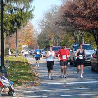
14 MIDTOWN will be an Exceptional Outdoor Experience. If you live and work in Midtown, you will never be more than a 10 minute walk to a park, trail or natural area. From children to seniors, walking in Midtown will be a clear option and a safe thing to do. Midtown will have a compelling canal-front and riverfront experience for residents and visitors. The White River will be a premiere urban recreational amenity in Indianapolis and the region. HISTORICAL PRECEDENTS IN INDIANAPOLIS The Central Canal has a long history of being a place of lush vegetation. EXAMPLES FROM OTHER CITIES This image, from 1907, illustrates that the Central Canal has long been a route for bike and pedestrian use in the Midtown area. In 1921, the White River was a urban recreation amenity. In Broad Ripple, canoe travel was a favorite activity. Kayak Pittsburgh is an organization that has reconnected the City of Pittsburgh with its various river systems and given opportunities to use the rivers responsibly. GUIDING PRINCIPLES: In Boise, Idaho, users float down the Boise River. Infrastructure is in place to accommodate users with kayaks, boats and other needed equipment. Sculpture and Art can enhance the visual interest and value of public recreation amenities, such as in Seattle s Olympic Sculpture Park The Indianapolis Regional Pedestrian Plan is a guide to integrating the pedestrian mode of travel into the Indianapolis urban transportation system. This report concludes a planning effort focused on Marion County and the Regional Center and offers excellent resources for understanding the potential for increased pedestrian activities in Midtown. The document includes design guidelines and recommendations for: Larger scale public art can have an identity-creating impact in a neighborhood or district. Many communities have separated bike and pedestrian traffic from auto traffic in residential communities. EXISTING CONDITIONS IN MIDTOWN Pedestrian District Pedestrian Corridor Greenways Off-street Greenway Urban Greenway Historic Parkway and Boulevard System The Indianapolis Arts Park at the Indianapolis Art Center is a premiere urban outdoor art park. Holcomb Gardens at Butler University is an open space along the Central Canal. Walkways Residential Sidewalks Collector Sidewalks Off-Street Paths Pedestrian Crossings 14 regpedplan/index.html Guiding Principles & Future Development Strategies The Indianapolis Museum of Art is leading the development of 100 Acres: The Virginia B. Fairbanks Art and Nature Park. The White River is currently used for light recreational uses including fishing and kayaking.
15 MIDTOWN will be an Exceptional Outdoor Experience. MIDTOWN: POTENTIAL PEDESTRIAN IMPROVEMENTS THE WHITE RIVER RECREATION PARK The White River is the major river land feature in Central Indiana. Unlike other urban communities, Indianapolis has not embraced this feature for recreation or other amenity. A White River Recreation Park would offer a named destination that focuses attention on the White River rather than ignoring it. Designated places for water sport rentals and clear access points are critical. THE MIDTOWN PEDESTRIAN TRIANGLE Meridian Street College Avenue Keystone Avenue Trails have become a major amenity in Indianapolis and Midtown is home to two of the most popular, the Monon Trail and the Central Canal Towpath. However, linkages between these great systems are weak. The Midtown Pedestrian Triangle would give connectivity for these systems as well as linking access to destinations such as the Museum of Art and State Fairgrounds that have a strong potential to draw pedestrian traffic. The triangle would be connected by a dedicated pedestrian route along 38th Street, a couplet of pedestrian oriented streets along 52nd and 46th called the Midtown Pass, and a re-established and comfortable walking zone along North Meridian Street called, ʻThe Stroll. RIVER ACCESS ARTS CENTER THE ART 2 ART PATH Midtown is home to two of Indianapolisʼ most premiere arts institutions, Kessler Blvd. the Indianapolis Museum of Art and the Indianapolis Arts Center. Despite this proximate geography, these two institutions have little adjacency in the minds of the general public. The Art 2 Art Path would follow the Central Canal Towpath but would serve as a linear sulpture and arts park. Not only would the Art 2 Art Path link these institutions, but it also would connect their significant outdoor arts endeavors, the IMAʼs Art and Nature Park and the Art Centerʼs ArtsPark. ALICE CARTER PARK / MERIDIAN STREET 61st Street Michigan Road White River Central Canal A R T 2 A R T P A T H HOLCOMB BUTLER UNIVERSITY 52nd Street THE MIDTOWN PASS 46th Street MONON TRAIL RIVER ACCESS IMA NATURE PARK CROWN HILL CEMETERY MIDTOWN MAPLE ROAD TRAIL THE MERIDIAN STROLL Fall Creek Blvd. 38th Street Fall Creek Guiding Principles & Future Development Strategies 15


16 MIDTOWN will be a Place of Investment. Midtown will embrace change and manage it to meet the values of its residents. Existing businesses and property owners will invest in themselves through various Economic Improvement Districts. Currently under-utilized properties will be tomorrow s heavily utilized sites. Real estate development opportunities will exist for smaller owners as well as larger owners. If you live and work in Midtown, in less than 10 minutes you will be able to walk to get something to eat and drink. HISTORICAL PRECEDENTS IN INDIANAPOLIS Neighborhoods in the Midtown area have historically had areas of concentrated commercial activity within residential neighborhoods. EXAMPLES FROM OTHER CITIES Many of Midtown s neighborhoods were home to local movie theatres and other entertainment facilities. Significant investment in residential and commercial properties has been found in Midtown for over 100 years. New infill development can fit into the existing character of a community and have a strong urban design presence at the street edge. GUIDING PRINCIPLES: From TEN PRINCIPLES FOR REBUILDING NEIGHBORHOOD RETAIL by the URBAN LAND INSTITUTE (ULI): New development in urban settings can create high quality experiences during both the day and evening. LIve / Work units allow for individual investment, increased residential density and reduction in automobile demand on area streets. Great Streets Need Great Champions It Takes a Vision Think Residential Honor the Pedestrian Parking Is Power Merchandise and Lease Proactively Make It Happen Be Clean, Safe, and Friendly Extend Day into Night Manage for Change media/documents/researchandpublications/reports/ TenPrinciples/TP_NeighborhoodRetail.ashx Attracting the Creative Class for employment requires facilities such as film and art studios. Park and open spaces can be designed to add value to surrounding development opportunities as well as be more usable and functional to the public. EXISTING CONDITIONS IN MIDTOWN Proposed mixed-use infill projects such as The Uptown represent future development opportunities on College. Larger buildings and warehouse spaces are located along the Monon Trail between 54th and 52nd Streets. Additionally, the book, City Comforts by David Sucher is an excellent guide to building urban villages. Sucher advocates for three basic principles of urban design: 1. Build to the Street Edge. 2. Make Building Fronts Permeable and Transparent. 3. Park in the Rear of Buildings or On- Street. In Broad Ripple Village, most development is oriented to Broad Ripple Avenue as opposed to the Central Canal. Tarkington Park at 39th/40th Streets between Meridian and Illinois is one of Midtown s largest park facilities. 16 Guiding Principles & Future Development Strategies
17 MIDTOWN will be a Place of Investment MIDTOWN: ENHANCED NEIGHBORHOOD CENTERS MAJOR REINVESTMENT OPPORTUNITIES While all of Midtown represents a significant investment opportunity, three locations have a major opportunity for catalyitic impact. These locations are areas where significant land and underutilized buildings exist. These locations are: COLLEGE & THE CANAL, 54th/52nd & THE MONON, and ILLINOIS/MERIDIAN & 38th STREET. Not only can these areas be destination places they also can be home to significant employment centers. NEIGHBORHOOD CENTERS (Shown with 5 Minute Walk Circles) Meridian Street College Avenue Keystone Avenue Neighborhood Centers are a part of the fabric of Midtown, providing small scale services in a walkable distance to residential neighborhoods. Some centers are clearly established, while others need focused attention. Regardless, each center should follow basic rules of urban design and placemaking when infill development occurs. COLLEGE & THE CANAL Kessler Blvd. Kessler & COLLEGE 56th Street & ILLINOIS AREA LACKING A NEIGHBORHOOD CENTER 54th Street & COLLEGE Michigan Road 52nd Street & COLLEGE 52ND/54TH & THE MONON White River Central Canal 49th Street & PENNSYLVANIA 49th Street & COLLEGE 46th Street & COLLEGE 46th Street & EVANSTON AREA MIDTOWN LACKING A NEIGHBORHOOD CENTER 42nd Street & COLLEGE 40th/42nd St. & Boulevard Place ILLINOIS / MERIDIAN & 38TH STREET 38th Street & COLLEGE Fall Creek Blvd. 38th Street 34th Street & ILLINOIS 34th Street & FAIRFIELD Fall Creek Guiding Principles & Future Development Strategies 17


18 MIDTOWN will be an Employment Generator. Because of its culture and brand, employers will want to locate their offices and facilities in Midtown. Midtown will accommodate excellent options for how you work including telecommuting, home office, live/work, traditional office, classrooms, studios and performance space. You will be able to walk or bike to work if you live in Midtown. HISTORICAL PRECEDENTS IN INDIANAPOLIS Arthur Jordan Hall at Butler University in Butler University has been the major educational institution of Midtown for over 80 years. EXAMPLES FROM OTHER CITIES The agricultural products exhibit at the 1935 Indiana State Fair. The Indiana State Fairgrounds has been located on 38th Street since The Indianapolis Museum of Art has been located in it s current location at Michigan Road and 38th Street since In urban settings such as Portland s Pearl District, open spaces have value and give address to residential and office loft development. GUIDING PRINCIPLES: Key values offered by considering employment in Indianapolis: Large, open floor plans or loft-style development creates opportunities for new economy office users. Office spaces can be integrated with residential and retail uses in well-designed mixed use buildings. LOW COST OF LIVING. Indianapolis consistently ranks high on the list of most affordable cities in the U.S. LOW COST OF BUSINESS. Central Indiana has some of the lowest business operating costs in the nation based on labor, energy, and taxes. EDUCATED WORKFORCE. The city is at the center of a higher education corridor producing tens of thousands of engineering, life science, advanced manufacturing, management, and logistics graduates annually. ACCESSIBILITY: Indianapolis is accessible by 5 major interstates, 5 rail lines, and a new $1 billion international airport. 75% of the U.S. & Canadian population can be reached in a one-day drive. Art and Performing Arts space requires wide open floorplans and often are best accommodated in older buildings with lower rent costs. Urban agriculture is playing a larger role in the future of cities. The proximity to the state fairgrounds is a possible opportunity for research and employment. EXISTING CONDITIONS IN MIDTOWN Hinkle Fieldhouse at Butler University is a symbol of Indiana Basketball tradition and pride. The Indiana State Fairgrounds hosts numerous large and small events throughout the year. why-indianapolis/ Additional economic development information can be found at: Indy Partnership Central Indiana Corporate Partnership (CICP) In Broad Ripple Village, large events are held in conjunction with a thriving everyday retail environment. The Indianapolis Museum of Art hosts over 375,000 visitors each year. 18 Guiding Principles & Future Development Strategies
19 MIDTOWN will be an Employment Generator MIDTOWN: ENHANCED EMPLOYMENT CENTERS MAJOR EMPLOYMENT CENTERS (Shown with 5 Minute Drive Circles) If Midtown is truly going to be an exceptional pedestrian and living experience, then employment centers must be located WITHIN the district. Fortunately, Midtown is home to several large employment centers. With the development of two additional centers (54th/Monon & 38th/Illinois), the entire Midtown district will be within a 5 minute drive/10 minute bike of an employment center. NEW EMPLOYMENT CENTERS Several new employment centers will emerge at key redevelopment site opportunities. Each center might take on a unique character and style, creating diversity for the potential residential base that would be employed in such facilities. Not each center will be a village as some might be larger facilities creating a larger platform for employment creation. Access and development opportunity will be key for success. Meridian Street College Avenue 5 Minute Drive / 10 Minute Bike Area Broad Ripple Village Keystone Avenue Kessler Blvd. 5 Minute Drive / 10 Minute Bike Area 5 Minute Drive / 10 Minute Bike Area 52nd/54th & The Monon Michigan Road White River 5 Minute Drive / 10 Minute Bike Area Central Canal Butler University MIDTOWN Museum of Art/CTS Illinois/Meridian & 38th Street State Fairgrounds Fall Creek Blvd. 38th Street Fall Creek 5 Minute Drive / 10 Minute Bike Area 5 Minute Drive / 10 Minute Bike Area Guiding Principles & Future Development Strategies 19


20 MIDTOWN will be a Public Policy Collaborator. Midtown will be a place where declining neighborhoods are improved before re-investment is not feasible. Organizations of people in Midtown will collaborate on public policy decisions with community leaders including land use and zoning, public infrastructure, schools, resource and funding allocations, public safety, marketing and economic development. Public policies in Midtown will be a reflection of the value of Midtown to the overall Indianapolis community. HISTORICAL PRECEDENTS IN INDIANAPOLIS Building and maintaining sidewalks is not a new endeavor for the City of Indianapolis as seen in this historical photograph. GUIDING PRINCIPLES: Eight Advantages to Form-Based Codes: Because they are prescriptive (they state what you want), rather than proscriptive (what you don t want), form-based codes (FBCs) can achieve a more predictable physical result. Since Alexander Ralston completed the plan for Indianapolis in 1821, city planning has played a major role in the formation of the City. KEY FOCUS AREAS Broad Ripple High School, shown in 1936, has produced graduates that lead their fields and is a part of the Indianapolis Public Schools system. FBCs encourage public participation because they allow citizens to see what will happen where - leading to a higher comfort level about greater density, for instance. Because they can regulate development at the scale of an individual building or lot, FBCs encourage independent development by multiple property owners. Strong relationships with community policing activities increases opportunities for partnerships between local police and community residents. Form Based Zoning or Codes have become a public policy tool to use urban design principles to shape development activities in a community. The built results of FBCs often reflect a diversity of architecture, materials, uses, and ownership that can only come from the actions of many independent players operating within a communally agreed-upon vision and legal framework. FBCs work well in established communities because they effectively define and codify a neighborhood s existing DNA. Vernacular building types can be easily replicated, promoting infill that is compatible with surrounding structures. Non-professionals find FBCs easier to use than conventional zoning documents because they are much shorter, more concise, and organized for visual access and readability. This feature makes it easier for nonplanners to determine whether compliance has been achieved. High quality schools, such as IPS School 84/Center for Inquiry, must become a part of an overall effort to tell a story of high-quality education opportunities in Midtown. Working to build strong public policy collaboration requires strong committed citizens and clear and consistent communications. EXISTING CONDITIONS IN MIDTOWN FBCs obviate the need for design guidelines, which are difficult to apply consistently, offer too much room for subjective interpretation, and can be difficult to enforce. They also require less oversight by discretionary review bodies, fostering a less politicized planning process that could deliver huge savings in time and money and reduce the risk of takings challenges. FBCs may prove to be more enforceable than design guidelines. The stated purpose of FBCs is the shaping of a high quality public realm, a presumed public good that promotes healthy civic interaction. For that reason compliance with the codes can be enforced, not on the basis of aesthetics but because a failure to comply would diminish the good that is sought. The Central Canal is owned by the City of Indianapolis Water Utilities and is a major part of the city s system. Broad Ripple Avenue has significant plans to create a complete street with accommodations for cars and people. Peter Katz, President, Form-Based Codes Institute 20 Guiding Principles & Future Development Strategies Plans are in process for improving Alice Carter Park at Meridian Street and Westfield Boulevard. Additional pedestrian connectivity improvements (crosswalks, median) will also be implemented. Over 30+ Community Meetings have occurred in Broad Ripple Village, along College Avenue and along 38th Street (Maple Road) to build support for form-based coding and public policy improvements in Midtown.


21 MIDTOWN will be a Public Policy Collaborator MIDTOWN: POTENTIAL REGULATORY ZONES THE MIDTOWN REVIEW PROCESS Much like the Regional Center process for Downtown Indianapolis, new development proposals would enter a pre-review process in the Midtown area. While the Regional Center process is a municipal review, the Midtown review would be conducted by a Midtown umbrella organization with support from individual neighborhood associations. Recommendations would then be forwarded to the City of Indianapolis for consideration in project approvals and permitting. Meridian Street College Avenue Keystone Avenue FORM BASED CODES Several key locations will have traditional zoning replaced with form-based zoning that focuses on building location, massing, orientation rather than building uses. These areas will be urban in nature and likely require unique approaches to parking managment and other recent regulatory hurdles brought on by suburban codes. COMPLETE STREETS POLICY Within the Midtown Zone, all new infrastructure projects that affect the right of way will be required to investigate and implement complete streets policies as determined by the Institute of Transportation Engineers (ITE) Complete Streets Guide. Kessler Blvd. FORM BASED CODE ZONE #1 FORM BASED CODE ZONE #2 Michigan Road White River Central Canal MIDTOWN FORM BASED CODE ZONE #3 Fall Creek Blvd. 38th Street Fall Creek Guiding Principles & Future Development Strategies 21


22 MIDTOWN will be an Identifiable Place. Currently successful individual neighborhoods will now be seen as a complete district or part of town that promises something special and unique. What the public once saw as individual institutions they will now see as places that are even better because they are a part of Midtown. When you hear about Midtown you ll be intrigued. When you come to Midtown, you ll want to stay. GUIDING PRINCIPLES: Branding is a term that is often misused and misunderstood and requires some clarification. EXAMPLES FROM OTHER CITIES A brand is the relationship between the user and the product or service, or in the case of community branding, the place. A brand describes the emotions and experiences users have when they interact with a place. A brand defines the central, timeless essence or soul of this place and its intangible, emotional core. A brand exists in the mind of the user and connects the user s own personal identity with that experience. A brand consists of a powerful set of promises that consistently deliver a relevant and distinctive experience, promising the same feelings and experiences every time the product or service is used, or the place is experienced. A brand must be relevant, differentiated from the competition, highly regarded, believable, and have emotional value. A brand, however, is not a slogan, tagline, a logo or an ad campaign. These are the marketing elements that help convey and communicate the brand, but are not the brand itself. Public art and sculpture has the potential to be a part of a style and identity of a community and gives visitors and future investors a comfort that the community cares. Communities and districts can gain an identity or theme around public infrastructure including trail systems. District signage can be put on top of local street signs to create a sense of arrival in a special district. Achieving a designation or award, as in Michigan communities with the Cool City Program can begin to distinguish a community in the marketplace. Community branding will typically involve a process which includes the following phases: Research and Analysis Successful community branding projects will invest considerable time and resources into research to ensure that strategies are grounded in true research insights. The research considers the emotional and logical assets of the community. Brand Development This phase includes the development of the brand strategy and positioning, the brand visualization and messaging, and the final concept evaluation. Large scale public art can create a sense of landmark and destination, beginning to develop a humor and personal interest that attracts visitors and investment. Events and festivals can be opportunities for a community to share their developed brand with a wider audience. EXISTING CONDITIONS IN MIDTOWN Marketing and Communications Plan Development This phase includes specific plans and guidelines for advertising, public relations, interactive, and potentially buzz /experiential marketing and communications. Standards are established which address graphic identity, tone, logo, color, fonts, etc. Launch and Implementation of Marketing and Communications Plan Understand that everything about the community is part of its marketing vehicle - for example, the weather, store fronts, schools, media articles about the area, as well as the marketing materials. This final phase will officially launch and implement the Marketing and Communications Plan, with ongoing processes and infrastructure for brand management in place. Bridges and structures are gateways in and of themselves, as illustrated by this bridge on the Monon Trail. Public art is already in place in parts of Midtown, including this example from Broad Ripple. The Fall Creek Bridge at Meridian Street is a gateway across Fall Creek, primarily for automobiles. Historic Districts and other neighborhood designations, such as the North Meridian Street Historic District, can offer credibility for a community from visitors. 22 Guiding Principles & Future Development Strategies
23 MIDTOWN will be an Identifiable Place MIDTOWN: POTENTIAL KEY ENTRANCES GATEWAYS TO MIDTOWN To enhance the recognition of Midtown as a special district of Indianapolis, key locations of entry to the district will be enhanced with public art, unique architecture, signage and landscape design. These locations will serve as 24/7, always on marketing of the Midtown identity and help establish a strong sense of connection to the place and community of Midtown. Meridian Street COLLEGE AVENUE BRIDGE College Avenue Keystone Avenue MERIDIAN STREET BRIDGE WESTFIELD BRIDGE Kessler Blvd. 62ND STREET KESSLER BLVD. BRIDGE Michigan Road White River Central Canal MIDTOWN 38TH STREET BRIDGE MICHIGAN ROAD BRIDGE FALL CREEK & STATE FAIR- GROUNDS Fall Creek Blvd. 38th Street Fall Creek CHILDRENʼS MUSEUM FALL CREEK & COLLEGE AVENUE Guiding Principles & Future Development Strategies 23
24 Moving Forward... A healthy dialogue and discussion should follow the reading of this document. As stated at the beginning, this document s purpose is to address the future of Midtown Indianapolis through broad strategies that can assist in building an even greater quality of life for the area. It will ultimately be the citizens of For More Information Contact: Midtown that decide what kind of community they would like to be in the future and therefore, they must make their voice known through public discussion, comment and debate. Communicating This document should not only be used as a planning tool, but also as a tool for communicating the commitment of the Midtown community towards building a strong district for the future. In this capacity, this document can be shown to business leaders, prospective employers and residents, schools and others to begin the discussion and dialogue that is critical to creating a strong community. Organizing for the Future Within this document, six key aspirations are outlined to guide the future of Midtown. Each of these aspirations offers an opportunity for organizing citizens and planning staff to focus on each aspirations s attitudes and goals. Therefore, the neighborhood organizations of Midtown should work to create committees or organizations under the topics of each aspiration. These committees would be comprised of citizens, professionals in the related fields, elected officials and planning staff. Each committee would work to become experts in finding ways to achieve the aspiration in the Midtown District and defending the intentions of the aspiration in future planning and development activities. This quest for such expertise would include research, education, outreach and discussion in the future. Creating Simple Design Guidelines or Zoning Using this document as reference, a new set of design guidelines or zoning should be established for parts of Midtown. In this process, the current zoning ordinance should be reviewed for both clarity and its feasibility in assisting the building of the kind of community outlined in this document. This new set of guidelines or zoning should be graphically-oriented, simple, and clear, lacking the confusing legal language of past ordinances and yet providing definitive direction. The goal of this product will be to give all users the ability to clearly understand both the planning intentions of the City and the guideline s theoretical underpinnings and rationale. (317) N. Meridian Street Indianapolis, Indiana PROJECT CONSULTANTS: Continuing Education Building a City is never a task that is complete. It is an on-going effort to create an always higher quality of life and seek opportunities to create an even better community. In this light, the organizations of Midtown must continue to seek opportunities to educate themselves on development practices, land use models and other topics which can assist in bringing knowledge to the community and increase overall quality of life. 24 Guiding Principles & Future Development Strategies
Ivywild On The Creek PRELIMINARY CREEK DISTRICT MASTER PLAN
 Ivywild On The Creek PRELIMINARY CREEK DISTRICT MASTER PLAN Introduction: Rejuvenating an extraordinary Creekside neighborhood THE CREEKSIDE DISTRICT The Ivywild On The Creek Neighborhood District Master
Plano Tomorrow Vision and Policies
 Plano Tomorrow Vision and Policies PLANO TOMORROW PILLARS The Built Environment The Social Environment The Natural Environment The Economic Environment Land Use and Urban Design Transportation Housing
TOD 101 CREATING LIVABLE COMMUNITIES WITH TRANSIT
 1 CREATING LIVABLE COMMUNITIES WITH TRANSIT What are transit Centered Communities? Benefits of Partnerships to Support and Implement What You Will Learn Portland s Pearl District Your Trainers Today Catherine
Wasatch CHOICE for 2040
 Wasatch CHOICE for 2040 Economic Opportunities We Can Choose a Better Future We enjoy an unparalleled quality of life along the Wasatch Front. People from all over the world are drawn to our stunning scenery,
Chapter 1: Introduction
 Chapter 1: Introduction The Penn Avenue Community Works Corridor Vision and Implementation Framework presents an integrated communitybased vision and a coordinated, long-term implementation framework for
Visioning Statement and Guiding Principles
 Visioning Statement and Guiding Principles Planning for the Future The General Plan The General Plan represents Woodland's shared vision of the future and defines a path to lead the community toward its
hermitage town center
 hermitage town center A Community Vision prepared by Strada for The City of Hermitage and The Mercer County Regional Planning Commission January 2007 table of contents introduction 3 design principles
DALY CITY VISIONING PROCESS COMMUNITY WORKSHOP 3 MAY 8, 2008
 DALY CITY VISIONING PROCESS COMMUNITY WORKSHOP 3 MAY 8, 2008 PROCESS General Plan - a statement of the community s values, vision and aspirations for now and into the future... Timeframe LONG TERM - 2030
REGIONAL ACTIVITY CENTER
 DRAFT REGIONAL ACTIVITY CENTER 70 EAST BENCH MASTER PLAN DRAFT 06 Introduction The East Bench Regional Activity center is comprised of large educational, research, medical, and employment centers. These
V. Vision and Guiding Principles
 V. Vision and Guiding Principles The Master Plan for the Powers Ferry Corridor seeks a foundation in the desires of the community. At times, various elements of the community offered opposing viewpoints,
Table of Contents. Elm Avenue Improvement Plan City of Waco, Texas. Introduction 1. Existing Context 1 Figure 1 2.
 Table of Contents Introduction 1 Existing Context 1 Figure 1 2 Plan Guidelines 3 Future Urban Form 4 The West-End 4 Main Street 6 The East-End 7 Figure 2 9 Public Improvement Recommendations 7 General
CHAPTER 7: Transportation, Mobility and Circulation
 AGLE AREA COMMUNITY Plan CHAPTER 7 CHAPTER 7: Transportation, Mobility and Circulation Transportation, Mobility and Circulation The purpose of the Transportation, Mobility and Circulation Chapter is to
Sahuarita District & Phase 1 Master Plan. Town Council December 11, 2017
 Sahuarita District & Phase 1 Master Plan Town Council December 11, 2017 Visioning Study Visioning Process Advisory Group Meetings Community Questionnaire Town Center Case Studies Community Analysis The
Realities and Assets in an In-Town Shopping Center
 SUSTAIN SOUTHERN MAINE MILL CREEK PILOT LESSONS LEARNED April 15, 2013 Realities and Assets in an In-Town Shopping Center 1. An older shopping district that was laid out in a low-density, strip center
greenprint midtown SUSTAINABILITY ACTION PLAN 2012
 greenprint midtown SUSTAINABILITY ACTION PLAN 2012 MIDTOWN ALLIANCE SOUTHFACE ENERGY INSTITUTE RENAISSANCE PLANNING GROUP SUSTAINABLE ATLANTA PERKINS+WILL 2 GREENPRINT MIDTOWN 1. Introduction Sustainability
Riverwalk Dreams compiled by Thomas P. Healy November 16, 2017
 Riverwalk Dreams compiled by Thomas P. Healy November 16, 2017 1986 Ripple Village Plan: A neighborhood plan developed by the City of Indianapolis Department of Metropolitan Development s Division of Planning
2040 LUP is a part of the Comprehensive Plan and carries the same legal authority. Economic Challenges
 1.1. Guiding Anchorage s Growth Where will new residents settle over the next two decades? Where will people work, shop, and play? Will there be enough room to grow? How will Anchorage look? Will growth
CAL POLY MASTER PLAN UPDATE, March 2015
 Some Key Themes in the General Guiding Principles Academic Mission The plan must foremost advance the University s academic mission and student success. Foresight and Adaptability The plan should take
Port Lavaca Future Land Use
 Port Lavaca Future Land Use Introduction The City of Port Lavaca is beginning to see sustained growth, after many years of relative stable population. New single family homes, apartments, and businesses
ELK GROVE GENERAL PLAN VISION
 2-1 CHAPTER 2: 2-2 CREATING OUR The Community Vision for Elk Grove, expressed through a Vision Statement and a series of Supporting Principles, is a declaration of the kind of community that Elk Grove
In surveys, Dallas residents say what they want to change most
 NEIGHBORHOODS ELEMENT In surveys, Dallas residents say what they want to change most in the city is its appearance they want it to look beautiful, with trees and pedestrian-friendly neighborhoods. The
Green Infrastructure The Indianapolis Greenways Connection
 Green Infrastructure The Indianapolis Greenways Connection Fewer things in the transportation industry today make better since than combining the needs for pedestrian and bike trails with the need to locate,
1 October Dear Citizens of Charlotte and Mecklenburg County,
 1 October 2011 Dear Citizens of Charlotte and Mecklenburg County, As co-chairs of the Center City 2020 Vision Plan Steering Committee, we are proud to present the Center City 2020 Vision Plan, which sets
The Five Components of the McLoughlin Area Plan
 The Five Components of the McLoughlin Area Plan This documents contains the complete language of the five components of the McLoughlin Area Plan: The Vision Statement The Values The Guiding Principles
Concord Community Reuse Project Goals and Guiding Principles. Overarching Goals (OG)
") Concord Community Reuse Project Goals and Guiding Principles Overarching Goals (OG) No priority is implied by the order of presentation of the goals and guiding principles. Overarching goals for the Concord
Concord Community Reuse Project Goals and Guiding Principles Overarching Goals (OG) No priority is implied by the order of presentation of the goals and guiding principles. Overarching goals for the Concord
East Central Area Plan
 East Central Area Plan Steering Committee Meeting March 8 th, 2018 CHUN Tears McFarlane House Vision Statement Development Opportunities Analysis Vision Elements 1. Equitable, Affordable and Inclusive
Chapter 2: Vision, Goals and Strategies
 Chapter 2: Vision, Goals and Lake Elmo Today & Tomorrow Comprehensive Plan 2040 2 VISION, GOALS & STRATEGIES - DRAFT 4-6-2018 INTRODUCTION Comprehensive Plan Purpose Perhapse the most important objective
HE VISION. Building a Better Connected Place
 HE VISION Building a Better Connected Place WALK INTO THE FUTURE. Life in Cranberry, 2030 Here s what our residents told us they wanted to see in their community by 2030: The Cranberry of 2030 is a place
Windsor Locks Transit-Oriented Development Planning Grant Request. Project Background
 Windsor Locks Transit-Oriented Development Planning Grant Request Project Background Downtown Windsor Locks runs along Main Street in the vicinity of the intersection of Routes 159 and 140. The current
CHAPTER 3 VISION, GOALS, & PLANNING PRINCIPLES. City of Greensburg Comprehensive Plan. Introduction. Vision Statement. Growth Management Goals.
 CHAPTER 3 VISION, GOALS, & PLANNING PRINCIPLES Introduction The Greensburg Comprehensive Plan is intended as a working community document. A combination of long and short-term goals, this document is intended
Midtown Greenway Land Use and Development Plan Executive Summary
 Midtown Greenway Land Use and Development Plan Executive Summary Introduction The Midtown Greenway Land Use and Development Plan sets policy direction for land use and development in the Midtown Greenway
1.4 TRANSIT VISION 2040 FROM VISION TO ACTION THEME 1: PUTTING TRANSIT AT THE CENTRE OF COMMUNITIES. Fully integrate transit with community design
 TRANSIT VISION 2040 FROM VISION TO ACTION TRANSIT VISION 2040 defines a future in which public transit maximizes its contribution to quality of life with benefits that support a vibrant and equitable society,
Robbinsdale LRT Station. CDI Development Guidelines. August Overview
 Robbinsdale LRT Station August 2018 Overview The City of Robbinsdale may have the coolest opportunity site along the 13 mile stretch of the Bottineau LRT corridor / Blue Line extension. Located a block
Small Area Plan. South Gateway
 Small Area Plan Adopted May 12, 2008 South Gateway Purpose. The South Gateway Small Area Plan defines the City s expectations for the future of the southern entrance to the City at Interstate 85 and Highway
Market Demand and Land Use
 Market Demand and Land Use Summary 57 Challenges 60-61 Guiding Principles 62 Strategy and Implementation 63-69 Establish a mix of uses that contribute to a vibrant downtown. 58 Summary Historically, downtown
SALISBURY TOMORROW Our Vision
 SALISBURY TOMORROW Our Vision Salisbury is committed to supporting a high quality of life and sense of community for all residents. These commitments need to be reflected in our community programs, services
FUNDING CORRIDOR REVITALIZATION
 FUNDING CORRIDOR REVITALIZATION Integrated corridor planning for the 21 st Century America Planning Association Annual Conference Atlanta, GA April 27, 2014 Mariia Zimmerman, MZ Strategies, LLC mariia@mzstrategies.com
Sustainably Repositioning Greyfield Sites. Greyfield Sites Anywhere
 Sustainably Repositioning Greyfield Sites Jim Constantine Looney Ricks Kiss Architects Todd Poole 4ward Planning Greyfield Sites Anywhere Pennsylvania Chapter American Planning Association Conference 2009
RE-Imagining the Downtown Colorado Springs Master Plan
 RE-Imagining the Downtown Colorado Springs Master Plan 2016 APA Colorado State Conference October 25, 2016 Overview 8:00 Welcome, Introductions, and Overview 8:15 Downtown s Planning History 8:30 A Market
Economy Vision Statements: Social Wellbeing Vision Statements: Natural Environment Vision Statements:
 Economy Vision Statements: 1. Our business environment makes us a region of choice for new employers as we encourage entrepreneurship and have a vibrant, diversified and resilient regional economy. 2.
Preliminary Plan Framework: Vision and Goals
 Preliminary Plan Framework: Vision and Goals Draft: May 2015 Introduction Since the Town of Milliken s comprehensive plan was last updated in 2010, the community was heavily impacted by the 2013 flood,
Living in Albemarle County s Urban Places
 Living in Albemarle County s Urban Places ALBEMARLE COUNTY, VIRGINIA A Closer Look at Albemarle s Approach to Managing Growth and Creating Quality Urban Environments www.albemarle.org Page 2 Living in
DRAFT Land Use Chapter
 Stevens Creek Urban Village DRAFT 1 18 17 Land Use Chapter INTRODUCTION This Land Use Chapter describes how the Stevens Creek Urban Village will accommodate the growth that is planned for it in the Envision
What. - Civic anchors including a park and an updated library branch
 SUMMARY What Master Plan aimed at delivering - A walkable, mixed-use downtown in the heart of University City anchored by UNC Charlotte and University Research Park - Civic anchors including a park and
PLAN ON A PAGE SUMMARY
 Questions? Please Call - 423-989-5518. PLAN ON A PAGE SUMMARY The Plan on a Page is a tool for the City of Bristol to engage Bristol s neighborhoods, community organizations, and interest groups to organize
CHAPTER 8 ISSUES, CONCERNS, CONSTRAINTS AND OPPORTUNITIES
 CHAPTER 8 ISSUES, CONCERNS, CONSTRAINTS AND OPPORTUNITIES Introduction This River Conservation Plan was developed during a time of tremendous activity and effort in planning the transformation of the Delaware
BROOKLYN PARK / 85TH AVE LRT STATION CDI DEVELOPMENT GUIDELINES DRAFT
 August 2018 Page intentionally left blank The Brooklyn Park Library adjacent to the 85th Ave LRT Station Area. OVERVIEW The Blue Line LRT Extension / Bottineau corridor offers a unique opportunity to leverage
Urban Planning and Land Use
 Urban Planning and Land Use 701 North 7 th Street, Room 423 Phone: (913) 573-5750 Kansas City, Kansas 66101 Fax: (913) 573-5796 Email: planninginfo@wycokck.org www.wycokck.org/planning To: From: City Planning
ALTERNATIVES WHAT ELSE IS POSSIBLE?
 ALTERNATIVES WHAT ELSE IS POSSIBLE? VISION STATEMENT Rather than make a ±$250 million investment that will lock in place and exacerbate the current dysfunctional system for at least 5 more decades Let
Sacramento Area Council of Governments (SACOG)
") Sacramento Area Council of Governments (SACOG) The Blueprint Vision The SACOG Board of Directors adopted the Preferred Blueprint Scenario in December 2004, a bold vision for growth that promotes compact,
Sacramento Area Council of Governments (SACOG) The Blueprint Vision The SACOG Board of Directors adopted the Preferred Blueprint Scenario in December 2004, a bold vision for growth that promotes compact,
Corridor Vision. 1Pursue Minnehaha-Hiawatha Community Works Project. Mission of Hennepin County Community Works Program
 1Pursue Minnehaha-Hiawatha Community Works Project Minnehaha-Hiawatha Community Works is a project within the Hennepin Community Works (HCW) program. The mission of the HCW program is to enhance how the
C. Westerly Creek Village & The Montview Corridor
 C. Westerly Creek Village & The VISION Community Vision When the goals of the city are achieved Westerly Creek Village, a distinctive community defined by Montview Boulevard and Westerly Creek, is a strong
Cumberland Region Tomorrow is a private, non-profit, citizen based regional organization working with Greater Nashville Regional Council
 Cumberland Region Tomorrow is a private, non-profit, citizen based regional organization working with Greater Nashville Regional Council and others in the public and private sectors, dedicated to planning
MALL REVITALIZATION CASE STUDIES
 MALL REVITALIZATION CASE STUDIES DECEMBER 9, 2012 MALL REVITALIZATION OVERVIEW Introduction Sample Case Studies prepared for Lacey Woodland District Steering Committee as it considers strategies to revitalize
Parks Master Plan Implementation: Phase I Waterfront Use and Design REPORT #: September 7, 2016 File #
 0 'O DI Lan-171-14 1 - THE CORPORATION OF THE TOWN OF COBOURG..,. STAFF REPORT TO: FROM: Mayor and Members of Council Dean A. Hustwick, Director of Recreation and Culture DATE OF MEETING: Committee of
7Page 91 CLEMMONS COMMUNITY COMPASS 7 COMMUNITY CHARACTER
 7 Community Character The beauty of Clemmons won t necessarily be a reflection of our past, but our future. This quote from Comprehensive Plan Steering Committee member Wayne Dodson captures the essence
40 Years of Smart Growth Arlington County s Experience with Transit Oriented Development in the Rosslyn-Ballston Metro Corridor
 40 Years of Smart Growth Arlington County s Experience with Transit Oriented Development in the Rosslyn-Ballston Metro Corridor A presentation by the Arlington County Department of Community Planning,
4.1.3 LAND USE CATEGORIES
 4.1.3 LAND USE CATEGORIES a. City Center District The City Center District incorporates the existing character and mix of uses in downtown Belmont to encourage redevelopment and new development in keeping
Today Land & People. Northeast Nampa Gateway District. Employment. Land Use Characteristics. Demographics. Current Zoning
 Today Land & People Employment Major employers include Saint Alphonsus, the College of Western Idaho, the Auto Mall, Sorrento Lactalis and Walmart. 3,004 jobs in 2010 (COMPASS-CIM 2040 TAZ data) 4,345
Create Policy Options Draft Plan Plan Approval. Public Consultation Events. Phase 2
 Background Grandview-Woodland Community Plan In the spring of 2012, the City of Vancouver embarked on a comprehensive community planning program in the Grandview-Woodland neighbourhood. The process has
Comprehensive Plan ADOPTED APRIL 2014
 Comprehensive Plan ADOPTED APRIL 2014 8 8. Outstanding Recreational & Cultural Opportunities We are proud of our community s parks and recreation system. Our community will ensure that the legacy of our
EXECUTIVE SUMMARY EXECUTIVE SUMMARY
 1 EXECUTIVE SUMMARY EXECUTIVE SUMMARY Penn s Landing is envisioned as a welcoming riverfront green space adjacent to a refurbished civic marina becoming the centerpiece for adjacent development. With a
About Momentum Midland
 About Momentum Midland Achieving a community s full potential in terms of economic development and quality of life is critically important to its long term sustainability. Core to achieving this is a vibrant
MONTGOMERY COUNTY METRO STATION AREA DESIGN CHARRETTE
 MONTGOMERY COUNTY METRO STATION AREA DESIGN CHARRETTE Shady Grove Metro Station Area Charrette Closing Presentation October 25-28, 2000 MONTGOMERY COUNTY, MD M-NCPPC Design Collective, Inc. Architects
Vision Plan Kickoff Meeting Summary Report
 Vision Plan Kickoff Meeting Summary Report October 2018 The Vision Plan With the redevelopment of the Amtrak Property, Penn Station Partners (PSP) seeks to build on the creative talent and entrepreneurial
TEMPLE MEDICAL & EDUCATION DISTRICT
 City of Temple, Texas TEMPLE MEDICAL & EDUCATION DISTRICT 1 Description. The City of Temple joined in partnership with key public and private entities to jointly promote education and medical activities
CHAPTER 1. Ms. Guajardo s Class - Central Elementary CH 1 1
 INTRODUCTION CHAPTER 1 Ms. Guajardo s Class - Central Elementary CH 1 1 1.1 SETTING South Centre City is a linear corridor south of Downtown Escondido paralleling Centre City Parkway and South Escondido
Economic Development & Housing Council Committee Comprehensive Plan Update September 20, 2005
 1 Economic Development & Housing Council Committee Comprehensive Plan Update September 20, 2005 Purpose To update the Committee on the ForwardDallas! Plan, including: Status Anticipated Products Public
ROBBINSDALE LRT STATION CDI DEVELOPMENT GUIDELINES
 August 2018 OVERVIEW The City of Robbinsdale has a prime-opportunity site in the middle of the 13 mile stretch of the Bottineau LRT corridor / Blue Line extension. Robbinsdale offers a prominent, vital,
Long Lost Allies? Walking Advocates & Business District Organizations. Matt Kazinka Lake Street Council. Shaina Brassard Seward Redesign
 Long Lost Allies? Walking Advocates & Business District Organizations Shaina Brassard Seward Redesign Rob Hanson West Broadway Business and Area Coalition Matt Kazinka Lake Street Council Jamie Schumacher
DRAFT ROOSEVELT ROAD. District Recommendations. Figure 5.23 The Roosevelt Road Corridor
 CHAPTER 5 Figure 5.23 The Road Corridor Road will develop as a mixed-use corridor, emphasizing regional retail, west of the river and mixed-use development east of the river. KEY RECOMMENDATIONS 1. High
The Lower SaLuda Greenway
 The Lower SaLuda Greenway InITIaTIve a FLourIShInG Greenway. a hub For economic GrowTh. a ConneCTIon BeTween CoMMunITIeS. In April 2017 the Michael J. Mungo Foundation and Lexington County commissioned
Public Art Plan. We have elected to submit Public Art Plans before or concurrently with the CSP Submittal per the FDP Manual
 Public Art Plan The intent of the Horizon Uptown Public Arts Program is to create great places that engage the community and leverage the neighborhood development and economic vitality. The Horizon Uptown
Strategic plan framework Steering Committee Meeting
 Strategic plan framework Steering Committee Meeting September 26, 2018 1 agenda 1 Welcome and Strategic Planning introductions Process Strategic Analyses Plan Framework 2 3 Brand Brand Development Naming
PREVIOUS PUBLIC PARTICIPATION BRIEF October 2014
 Comprehensive Planning During the development of the county comprehensive plan, Cultivating Community: A Plan for Union County s Future from 2007 through 2009, and three concurrent multi municipal plans
2.0 THE PLATINUM TRIANGLE VISION
 2.0 THE PLATINUM TRIANGLE VISION The envisions an exciting future for the area surrounding Angel Stadium of Anaheim, the Honda Center and The Grove of Anaheim. 2.1 Planning Principles In order to further
Atlanta BeltLine Subarea 3 Master Plan Update
 Atlanta BeltLine Subarea 3 Master Plan Update April 14, 2018 Workshop Meeting 1 22 miles, connecting 45 neighborhoods 22 MILES of transit 46 MILES of streetscapes and complete streets 33 MILES of urban
CITY OF RENO APRIL Progressive Urban Management Associates (P.U.M.A.) in association with. Economic and Planning Systems (EPS)
 in association with. Economic and Planning Systems (EPS)") CITY OF RENO APRIL 2017 City of Reno, Nevada Prepared By Progressive Urban Management Associates (P.U.M.A.) in association with Economic and Planning Systems (EPS) EXECUTIVE SUMMARY The City of Reno Downtown
CITY OF RENO APRIL 2017 City of Reno, Nevada Prepared By Progressive Urban Management Associates (P.U.M.A.) in association with Economic and Planning Systems (EPS) EXECUTIVE SUMMARY The City of Reno Downtown
Transportation. Strategies for Action
 Transportation A major priority for the Overlake Neighborhood is to develop a multimodal transportation system. To achieve this system, a balance has to be found among travel, circulation and access needs;
Town Center (part of the Comprehensive Plan)
") Town Center (part of the Comprehensive Plan) Mercer Island Town Center Looking North (2014) In 1994, a year-long process culminated in a set of design guidelines and code requirements for the Town Center
Town Center (part of the Comprehensive Plan) Mercer Island Town Center Looking North (2014) In 1994, a year-long process culminated in a set of design guidelines and code requirements for the Town Center
Chapter 4. Linking Land Use with Transportation. Chapter 4
 Chapter 4 Linking Land Use with Transportation Chapter 4 59 Chapter 4 Linking Land Use with Transportation Community Design and Transportation Program Introduction Since the 1950s, the predominant development
MONTCO 2040: A SHARED VISION The New Comprehensive Plan for Montgomery County. Dra Themes and Goals March, 2014
 MONTCO 2040: A SHARED VISION The New Comprehensive Plan for Montgomery County Dra Themes and Goals March, 2014 INTRODUCTION 2 WHAT IS A COMPREHENSIVE PLAN? A comprehensive plan is a long-range plan required
Route 1 Corridor Study
 Route 1 Corridor Study Westbrook, Connecticut A Vision for the Connecticut Shoreline Public Informational Meeting July 28, 2015 Lower Connecticut River Valley Council of Governments Fitzgerald & Halliday,
Embrace Green Urban Space:
 1 Embrace Green Urban Space: Parks/Green Space as Vital to Urban Livability Jenna Fletcher The Trust for Public Land LUAC November 15, 2012 2 The Trust for Public Land conserves land for people to enjoy
Implementation Guide Comprehensive Plan City of Allen
 Implementation Guide 2030 Comprehensive Plan City of Allen DRAFT 2015 Implementation Guide Allen 2030 Comprehensive Plan INTRODUCTION The Comprehensive Plan serves as a guide for the growth and development
b r a n c h av e n u e tr a n s it co r r i d o r r e vita lization pl a n a m o d el fo r s u b u r ban retro fit
 b r a n c h av e n u e tr a n s it co r r i d o r r e vita lization pl a n a m o d el fo r s u b u r ban retro fit P R I N C E G EO RG E S CO U NT Y, M D ADO PTED 0 p R O J E C T C AT E G O R Y : U R B
PLAN ELEMENTS WORKSHOP. April 5, 2016
 PLAN ELEMENTS WORKSHOP April 5, 2016 needs more housing. But there is no one-size fits-all solution. Every neighborhood has its own character. In some places, density is not only appropriate it is badly
Elliot Park 4. Neighborhood Master Plan. The Master Plan
 Elliot Park 4 Neighborhood Master Plan August 2002 Why Master Plan? Construction cranes signal new growth downtown as the backdrop to this smaller scale, quiet neighborhood. Do nothing or plan for the
Nader Obied Abd al raheem hathat. Dr. Farid S. Al-Qeeq
 Submit from Nader Obied Abd al raheem hathat Submit to Dr. Farid S. Al-Qeeq DEC. 2010 NEW URBANISM : is the most important planning movement this century, which emerged during the late 1980s and early
Taming Tysons Corner Transforming the Quintessential Edge City
 Taming Tysons Corner Transforming the Quintessential Edge City Transit is the greatest catalyst for change at Tysons, but how do we take advantage of this billion-dollar investment? If transit is built
Gold Line Bus Rapid Transit Transit Oriented Development (BRTOD) Helmo Station Area Plan
 Helmo Station Area Plan") Appendix F Gold Line Bus Rapid Transit Transit Oriented Development (BRTOD) Helmo Station Area Plan Introduction and Purpose of the Plan The Gold Line Bus Rapid Transit facility is an eleven-mile dedicated
Appendix F Gold Line Bus Rapid Transit Transit Oriented Development (BRTOD) Helmo Station Area Plan Introduction and Purpose of the Plan The Gold Line Bus Rapid Transit facility is an eleven-mile dedicated
The John Bartram Association Action Plan to advance the 10 year Strategic Plan
 The John Bartram Association 2013-2015 Action Plan to advance the 10 year Strategic Plan We are poised to take significant leaps with the opportunities that surround us. In the next three years we are
SECTION ONE: INTRODUCTION. introduction
 introduction 1 INTRODUCTION Since it was first established in 1843 as a trading post for the Hudson s Bay Company, Victoria has evolved into a Provincial capital city that is recognized across Canada and
East Bench Master Plan Update
 Community & Economic Development Office of the Director East Bench Master Plan Update To: From: Planning Commission Wayne Mills, Senior Planner Date: November 18, 2015 CC: Re: Nora Shepard, City Planning
CITY OF UNION CITY MINUTES GENERAL PLAN ADVISORY COMMITTEE
 CITY OF UNION CITY MINUTES GENERAL PLAN ADVISORY COMMITTEE WEDNESDAY, MARCH 4, 2015, 6:30 P.M. IN THE CITY COUNCIL CONFERENCE ROOM OF CITY HALL 34009 ALVARADO-NILES BLVD., UNION CITY, CALIFORNIA Attachment
DINING ENTERTAINMENT SHOPPING
 DINING ENTERTAINMENT SHOPPING Proscenium is a unique community that combines the ease of upscale living with the luxury of retail shops and dining options right outside your front door. Perfect for young
A Plan for the Heart of the Region: Tukwila, WA
 : Tukwila, WA 1 The Plan orchestrates the Restructuring of a 1,000-acre Regional Shopping Area into a Social and Symbolic for the Region. REGIONAL CONTEXT Downtown Seattle (Metropolitan ) 20 miles Bellevue
Sustainable Urban Planning:
 Sustainable Urban Planning: A More Energy Efficient Lifestyle with a Return to the Walkable City Elizabeth Monterrosa Energy Law Spring 2009 emonterrosa@kentlaw.edu Walkable City v. Urban Sprawl European
4- PA - LD - LIVELY DOWNTOWN. LD - Background
 4- PA - LD - LIVELY DOWNTOWN LD - Background The downtown has been the service centre for the community since the city s inception and the area continues to supply people with their personal services,
The University District envisions, in its neighborhood
 Envisioning the University District Link Light Rail in Seattle s neighborhoods CIY OF SEALE CONCEP-LEVEL SAION AREA PLANNING RECOMMENDAION RESOLUION # 30165 EXHIBI L Vision 08.2000 he University District