Environmental and Landscape Mapping
|
|
|
- Martha Elliott
- 5 years ago
- Views:
Transcription


1 Environmental and Landscape Mapping In support of the Calveley Neighbourhood Plan November 2016
2 Project Name and Number: Calveley Neighbourhood Plan Document Name and Revision: Environmental and Landscape Mapping Prepared By: SH Reviewed By: JG Date of Issue: 15/02/2017 Urban Imprint Limited Company number Registered in England and Wales Registered Office 82 Reddish Road Stockport SK5 7QU
3 Contents Calveley Spatial Portrait...4 Blue & Green Infrastructure...5 Movement...7 Heritage Assets...8 Views and Vistas...10 Character Areas...12 Capacity for Change...13 Potential Development Sites...14
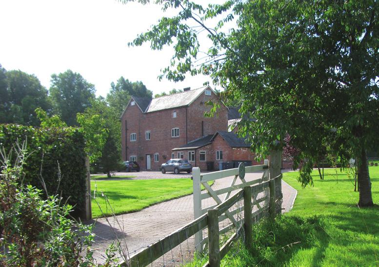
4 Calveley Spatial Portrait N Calveley Parish is characterised by a series of scattered farms and open space, as well as a residential village, school and Church. There are some commercial clusters towards the South of the Parish, including a coal depot, a cheese factory and petrol station. Wardle employment area is the large commercial land to the South of Calveley lying outside the parish boundary. Calveley Village (identified on the map to the South West of Calveley) is a small residential estate that lies off the main road. A new site is currently being developed adjacent to the village for a proposal of six residential units. Although Calveley is a relatively small-scale rural area, the dispersed farms provide some consistency along the main road. Neighbouring areas (such as Crew to the South) provide additional commerical facilities for residents. Calveley Parish Railway Highway Farm Calveley Village The Southern boundary of Calveley Parish features 3 major movement corridors: the Shropshire Union Canal, the A51 and the Crewe to Liverpool Railway line. Commercial Land Figure 1: Calveley Spatial Portrait 4
5 Blue & Green Infrastructure N Calveley Parish Water Features Building Field Boundary Protected Woodland TPO (13) Highway Figure 2: Blue & Green Infrastrucutre 5
6 Blue & Green Infrastructure Figure 2 shows the natural features which make up the broad landscape pattern of the parish. Features such as the hedgerows, field trees, stands of woodlands and a variety of small ponds help to create a mixture of different habitat features. The pastoral landscape which has typically characterised this landscape dairy farming has allowed many of the features of the landscape to be retained. Green corridors are relatively rare within the area, being mainly related to transportation infrastructure (road verges, railway cutting and the canal); certainly the two principle roads crossing the parish Calveley Hall Lane and Calveley Green Lane - are particularly important offering wide verges, well maintained hedgerows and a series of large mature hedgerow trees. of the remaining stands or copses of trees that once characterised the landscape. Some mature plantations in and around the former Calveley Hall help to increase the tree cover and the range of habitats available. One of the other features of the landscape is a series of small ponds. Many of these ponds are used for watering cattle have therefore remained. These ponds, many of which will change in size and content with the seasons, are particularly important to local wildlife and support a range of different habitats. When coupled with the standing water of the canal, they offer a range of habitats for waterborne flora and fauna. The parish has a series of fairly regular field boundaries creating medium sized pastures, however the strength of this pattern within the southern portion, coupled with the larger blocks of woodland helps create a more accommodating landscape pattern to support biodiversity. Adjacent to Calveley Hall Lane, small paddocks, associated with the farms create a tighter landscape pattern not found elsewhere Field patterns to the north of the parish, whilst still distinct have lost much of the tree cover that once characterised the landscape, whilst in the south and east, the mixture of hedgerow trees coupled with multispecies hedgerow is more common. The southern area also has the majority 6
7 Movement N The A51 is a main arterial route that lies on the Southern boundary of the parish where the clusters of commercial use are located. As well as this route, Calveley Hall Lane and Calveley Green Lane form main routes that travel through the parish and connect farms that border the roads. There are a number of walking routes and public footpaths of varying quality throughout Calveley. Some routes are not metalled and are difficult to find with limited accessibility and legibility. In fact, many of the footpaths are blocked or have overgrown vegetation on the styles, this is especially challenging for those less-abled. Additionally, the Canal towpath has poor surfacing, which is especially unsafe in wet weather. This makes it an undesirable route for dog-walkers and those who wish to enjoy the canal. The towpath is narrow and poorly sign-posted, it also lacks a connection with the footpaths that connect to the A51 and therefore presents a barrier of movement. Calveley Parish Bus Stop Water Features Building Highway Footpath Figure 3: Calveley Movement 7
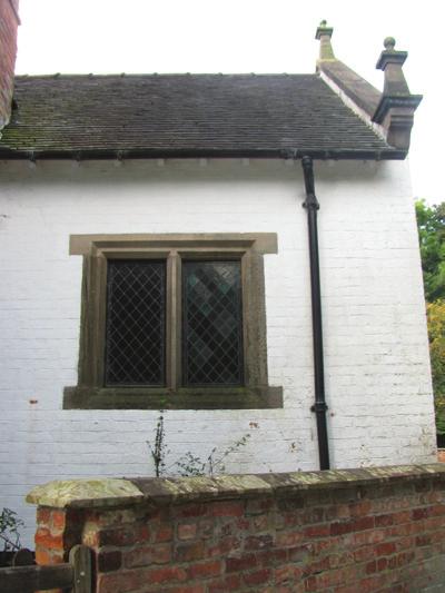
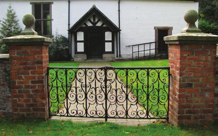
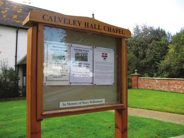
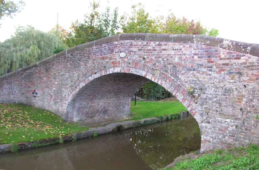
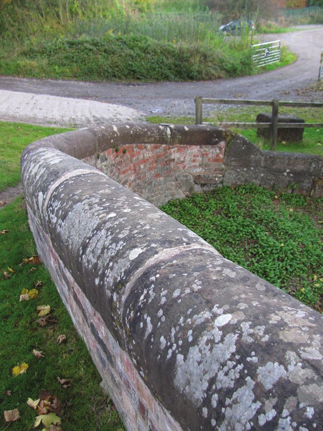
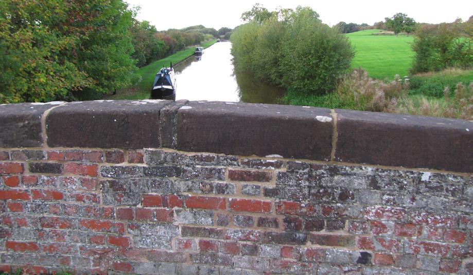
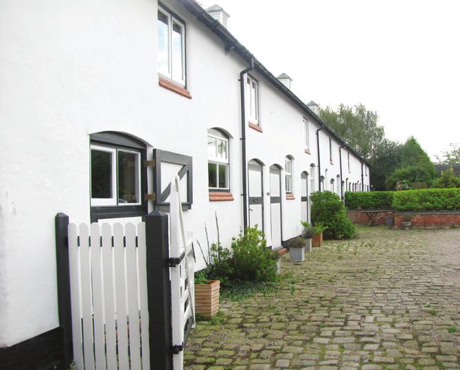
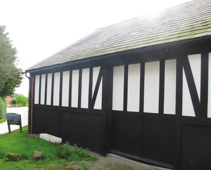
8 Heritage Assets N 1 Calveley Parish is ripe with heritage assets. There are a total of four listed buildings within the parish boundary [corresponsing photographs on page 6]: The Woodlands Farmhouse (Grade II listed from the late 18th Century). A C B Calveley Parish Church (Grade II listed built in the late 17th Century as a coach house and converted to a chapel in the mid-19th Century). Former Stables of Calveley Hall (Grade II listed stables from the mid-19th Century). Clays Farm Bridge (Grade II listed bridge for Clays Farm over the Canal from the 18th Century). 4 E F D G H 3 I J Building Highway Other notable heritage assets are [From the Historic Environment Records]: The Chester to Crewe Railway Line and Railway Cutting that dates back to The Watfield Pavement once passed through the parish and is thought to have formed part of a Roman Road from Chester to Chesterton. RAF Calveley Airfield (now a Satellite tracking station) Figure 4: Heritage Assets Railway Canal Listed Buildings Key Heritage Assets The areas highlighted as Key Heritage Assets are assets that should be considered valuable to the heritage of Calveley and that enhance it s distinct local character. These areas (labelled A-J) are further outlined in the Local Listing Report. 8

9 Heritage Assets


10 Views and Vistas N There are also views along the narrow and curved roads of Calveley Hall Lane and Calveley Green Lane. Level hedgrows and green verges enhance the natural character and arrangement of the route throughout the parish and create enclosed connected spaces Calveley benefits from a range of views and vistas, in fact almost every view is significant. Uninterupted and long-spanning views have been identified on Figure 5; these are often across farmland or from view points such as the railway bridge and the canal bridge. The views often follow field boundaries and tree clusters, as highlighted on the map. 6 8& &4 1 2 KEY Calveley Parish Field Boundary Water Features TPO Building Protected Woodland Highway 13 Footpath Field Boundary Key View Figure 5: Views and Vistas 10 Calveley street scape


11 Views and Vistas 1 6 Flat topography with scattered trees in the distance Enclosed views by flat land and hedgerows. Each field has individual character. Mature trees lining a main route with fenced fields and long-distance views. Wide-spanning sloping views over trees and closed field boundaries. Views blocked by mature clusters of trees including areas of protected woodland in the distance. Short-distance views blocked by dense hedgerows and interrupted by pylons. 3&4 8&9 13 Long-distance views of the railway line including power cables and the Wardle employment area in the South. Footpath leading to flat land with pond. Trees are scattered and mature. Highly rich in vegetation with views of hills in the far distance interrupted by clusters of mature trees This view travels against the field boundaries and is therefore interrupted by hedgerows and lies parallel to rows of leafy trees. Long-distance sloping views of the North of the parish with a high population of trees. Peaceful and still views over canal, lined by vegetation. 11
12 Character Areas N Identifying character areas is important when considering the overall nature of Calveley and potential interventions for the Neighbourhood Plan. This will help to maintain the character and preserve significant features of the landscape. There is a distinct character towards the South of the parish (communications corridor). This area is defined by high density commercial and residential uses as well as transport infrastructure in the form of the Canal, railway and the A51 arterial route. Within this defined character area, the residential village forms an inner character that has its own exclusive style from the rest of the parish. The Open Landscape and Enclosed Landscape character areas are areas of open space that are typical of the natural environment of Calveley. The areas have been divided due to their varying views and scale; the views to the East are less expansive and appear to have more vegetation than that of the Western area which is more expansive as a result of the topography and framed by trees. The central Calveley Hall character area has been defined by its peaceful atmosphere and Calveley Hall Lane. Similarly to the Communications Corridor Character Area, there is an inner character area- Key Heritage Area- Building Open Landscape Character Area defined by its heritage assets. Figure 6: Character Areas Highway Railway Line Calveley Hall Character Area Key Heritage Area Communications Corridor Character Area Calveley Village Movement Band Character Area Enclosed Landscape Character Area The movement band is an important central route to all areas of the community. It is characterised by its many wide-spanning views across farmland and open areas. The majority of the farms lie within this area and are set back from the lane by small paddocks. 12
13 Capacity for Change Open Landscape Character Area Movement Band Character Area This Character Area has a very limited capacity for change due to its valuable natural assets and views. Development for housing or any other use should be strongly avoided to retain the natural characteristics of Calveley. Enclosed Landscape Character Area Similarly to the Open Landscape Character Area, development in this area should be avoided. However, there is potential for some additional farmuse buildings provided they are consistent with the scale and style of the existing farmhouses and do not detract from the natural views. Calveley Hall Character Area This area has a limited capacity for change due to the dense heritage assets and historical character. Any new development, soft or hard, must be sensitive to the existing heritage of the area. Infrastructure improvements such as view-points and new fencing are welcomed to enhance the environmental assets and usability. This route has potential for additional farmhouses that are consistent with the existing buildings in scale and style, and are not intrusive to the views of the landscape. A notable style of this area is the set-back of farm buildings from the road by small paddocks. Other residential uses or any other uses are not appropriate for this area as consistency of farmuses should be maintained. Communications Corridor Character Area The Communications Corridor has the greatest capacity for change compared to the other Character Areas. The density of Calveley Village should be maintained and housing development should be concentrated in and around the village area to increase vitality and enhance community facility potential. Infrastructure by the Canal that aims to create community areas or connect developments across the road and railway line will also be welcomed. There is potential for new small-scale commercial uses in this area, preferably in walking distance to new developments around Calveley Village. The Calveley Village area within the Communications Corridor Character Area should aim to become a self-sufficient community hub that is well connected with community infrastructure and the Canal for pedestrian use. 13
14 Potential Development Sites Options Diagram 1. Coal Merchants Yard Potential for housing. These could be advertised as starter homes to respond to the deficiency of smaller sized properties in Calveley. Locational advantages such as proximity to the bus route, connectivity to the main road and shared accessibility with the current Village. High-density housing is advised on this plot to create a mix of density and is appropriate for the scale of the plot (approximately 0.1 hectares). Therefore the site would accommodate a minimum of 4 hous- 14 es at the lowest end of high-density housing. The potential for development on this site will depend on the ownership of the land and the decision of the current owner of the Coal Yard. Consideration should also be taken to any possible contamination of land from Coal prior to housing development. 2. Plot behind village This plot is currently the extent of the curtilage of an existing dwellinghouse. With potential to replace this dwellinghouse with housing development, the accessibility would need improving into the site from Station Road. The plot is the largest potential housing development site- approximately 0.75 hectares. The most appropriate density for this area would be a continuation of medium density housing from the adjacent Calveley Village area, as well as some high-density terraced housing. If 0.5 hectares was to be used for medium density housing, and 0.25 for terraced housing, a total of 15 semi-detached housing and 5 terraced houses would be viable in this area. This area is constrained by the land ownership. The potential of housing on this site will depend on the current owner. 3. Green Triangle This area has great potential for connecting the main Calveley Village housing cluster with the Canal area, therefore utilising this site for connectivity infrastructure would be appropriate. The area is 0.17 hectares therefore, there is also room for some housing, either for low-density housing in the form of 1 dwelling house, or high-density in the form of a 2 rows of terraced houses (7 dwellings in total). Site ownership should be considered as well as improved access and connectivity to the main village. 4. New housing development site Site currently under development for cluster of houses adjacent to current Calveley Village. 5. Canal-Side Development This area is appropriate for the development of tourism and leisure facilities. (See Calveley mini-masterplan document on Canal-Side development). If Calveley Village was to expand, this site is an appropriate location for small-scale commercial and leisure uses. Development on this site should consider constraints such as the road that connects Calveley Village and the noise from the railway line. Communication should also be made with the Canal and Rivers Trust that own the land.

15
ENVIRONMENTAL AND LANDSCAPE MAPPING
 APPENDIX IV : Environmental and Landscape Mapping ENVIRONMENTAL AND LANDSCAPE MAPPING Calveley Neighbourhood Plan November 2016 ENVIRONMENTAL AND LANDSCAPE MAPPING Calveley Neighbourhood Plan Calveley
Site ref: AS06 Site Name or Address: Murreys Court, Agates Lane
 Site ref: AS06 Site Name or Address: Murreys Court, Agates Lane Proposed Land Use: Total Site Area (Ha): Housing 1.85 Ha Description: It is understood that the owner has no plans to dispose of the site
LONGDEN VILLAGE DEVELOPMENT STATEMENT
 LONGDEN VILLAGE DEVELOPMENT STATEMENT 2017-2027 1 Longden Development Statement 2017-2027 15/01/18 1. Background 1.1 Longden Village Longden village is a very rural and traditional community first mentioned
Toddington Central Bedfordshire Stage 3 Green Belt Study December 2017
 Toddington Central Bedfordshire Stage 3 Green Belt Study December 2017 Site: ALP086 - Middle Lakes, Toddington Site size (ha): 2.83 Site: ALP086 - Middle Lakes, Toddington Site size (ha): 2.83 Site description
Droitwich Spa 6. Reasoned Justification
 87 Droitwich Spa 6 Reasoned Justification 6.1 Droitwich Spa is identified in the settlement hierarchy (Policy SWDP1) as a main town being the largest settlement in Wychavon District with an estimated population
Settlement Boundaries Methodology North Northumberland Coast Neighbourhood Plan (August 2016)
") Introduction This background paper sets out a methodology for the definition of settlement boundaries in the North Northumberland Coast Neighbourhood Plan. The neighbourhood plan is planning positively
Introduction This background paper sets out a methodology for the definition of settlement boundaries in the North Northumberland Coast Neighbourhood Plan. The neighbourhood plan is planning positively
1.0 INTRODUCTION. Brantham Industrial Area Regeneration - Factory Lane - Brantham
 1.0 INTRODUCTION Welcome to this exhibition of our proposals for the regeneration of the Brantham Industrial Area located off Factory Lane in Brantham. This presentation will give you an opportunity to
8.0 Design and Form of Development 43/
 42/ 8.0 Design and Form of Development 43/ Rothwells Farm, Golborne/ Development Statement Figure 7. Site Constraints Key 44/ Site Boundary 360 Bus Route/Stops Existing Trees Underground Water Pipe Sensitive
WELCOME. Land North of STEVENAGE. We would like to thank you for attending our public exhibition today.
 WELCOME We would like to thank you for attending our public exhibition today. The purpose of this event is to share our proposals and hear your thoughts on our ideas. Members of the project team are on
ALLERTHORPE NEIGHBOURHOOD PLAN
 Allerthorpe s Neighbourhood Plan sets out a vision for the Parish for the next 15 years (2018 2033) that builds on and reflects the opinions and views of parish residents. VISION In 2033 Allerthorpe will
National Character Area 70 Melbourne Parklands
 Summary The are a landscape of rolling farmland, parkland and woodland on the northern flanks of the ridge between Burton upon Trent and Swadlincote. The land slopes down to the River Trent, which borders
Warwickshire County Council. Upper and Lower Brailes. Landscape Study
 Warwickshire County Council Upper and Lower Brailes Landscape Study Produced by WCC Landscape Architects March 2016 Landscape Assessment of Potential Development Sites within the parish of Brailes 1.0
INTRODUCTION. Land south of Bishopswood Lane, Tadley
 0 INTRODUCTION THE SITE Introduction Gladman Developments Ltd. has successfully invested in communities throughout the UK over the past 0 years, developing high quality and sustainable residential, commercial
About 10% of the Borough's population lives in the seven rural parishes. Population figures from the 1991 census are given below:-
 8. THE DISTRICT VILLAGES 8.1 Population About 10% of the Borough's population lives in the seven rural parishes. Population figures from the 1991 census are given below:- Village No. of Persons Cottingham
Ashtead Neighbourhood Forum Site Assessment AS03 Lime Tree Lodge, Farm Lane. Site address: Lime Tree Lodge, Farm Lane. Proposed Land Use:
 Site ref: AS03 Site address: Lime Tree Lodge, Farm Lane Proposed Land Use: Total Site Area (Ha): Housing 1.25ha Description The site is located off Farm Lane at the junction with Park Lane. To the north
East Harptree Landscape & Character Assessment
 East Harptree Landscape & Character Assessment Produced by East Harptree Parish Council in consultation with local residents September 2014 Contents The Parish of East Harptree: Objective Introduction
WELCOME. Land west of Great Canfield Road, Takeley. Welcome. Have your say. Pegasus Urban Design
 01 WELCOME Welcome Gladman Developments Ltd have successfully invested in communities throughout the UK over the past 20 years, developing high quality and sustainable residential, commercial and industrial
Character Area Summary 6: Canal Zone Stonehouse Town Character Assessment, Bridgend Works from Downton Road
 Character Area Summary 6: Canal Zone An open area, with residential and industrial areas, which has a rural character and a rich historic and natural environment strongly influenced by the Stroudwater
Table of Allocated Housing Sites
 Draft as of 0 November 016 Table of Allocated Housing s Name Green 1 (30, 33, 10, 169, 36/ 100) Barratt s Farm Balsall Common Yes 57 800 Includes existing park. Listed buildings to edge of site. of search
Welcome to our public exhibition
 About our development Welcome to our public exhibition This exhibition gives you the chance to view and comment on our proposals for a new residential development of 165 high-quality homes, along with
Neighbourhood Planning Site Assessment Pro-forma and Guide Version 2
 Neighbourhood Planning Site Assessment Pro-forma and Guide Version 2 September 2014 Site HNP 006 Land East of Stanbridge Road and North of Lower Road 1. Background information Site location and use Site
Public Consultation. Land at Monks Farm, North Grove. Welcome
 Welcome Welcome to our public exhibition for development on Land at Monks Farm, orth Grove. Gallagher Estates and Gleeson Strategic Land are preparing an outline planning application for new homes, open
1. Nantwich - Planning for a Sustainable Future
 1. Nantwich - Planning for a Sustainable Future Cheshire East Council is charged with preparing its Development Plan to guide housing and other growth over the period to 2030. The Council intends to publish
Neighbourhood Planning Guidance Local Green Spaces
 Neighbourhood Planning Guidance Local Green Spaces Introduction This guidance note has been produced for communities preparing neighbourhood plans in North Dorset to help them to identify, assess and designate
Chapter 2: OUTLINE PLANNING APPLICATION PROPOSALS. A New Garden Neighbourhood Matford Barton 17
 Chapter 2: OUTLINE PLANNING APPLICATION PROPOSALS A New Garden Neighbourhood Matford Barton 17 2.1. SUMMARY AND STATUS OF THE PROPOSALS 2.1.1. The parameter plans and associated wording in this chapter
Development Brief Ursuline Convent, Blackrock, Cork
 Development Brief Ursuline Convent, Blackrock, Cork Comhairle Cathrach Chorcaí Cork City Council 2002 URSULINE CONVENT DEVELOPMENT BRIEF 1 INTRODUCTION AND MAIN OBJECTIVES... 3 1.1 The convent estate is
Welford-on-Avon Neighbourhood Plan Consultation Event Sunday, 6 April Your name Your address
 Welford-on-Avon Neighbourhood Plan Consultation Event Sunday, 6 April 2014 Your name Your email address Please either: - complete this feedback form and put it in the box before leaving the Memorial Hall
PDP DESIGN & ACCESS STATEMENT
 PDP The Planning & Design Partnership Planning.. Architecture.. Interiors.. Landscape The Chicory Barn Studio, The Old Brickyards, Moor Lane, Stamford Bridge York, The East Riding Of Yorkshire, YO41 1HU.
INTRODUCTION. Land off Main Road, Great Leighs. Introduction
 01 INTRODUCTION Introduction Gladman Developments Ltd have successfully invested in communities throughout the UK over the past 20 years, developing high quality and sustainable residential scheme. We
Welcome to our Public Consultation
 About our development This exhibition gives you the chance to view and comment on our emerging plans for a proposed residential development located on land to the West of Alwyn Road, Rugby. Welcome to
3.3. Urban Structure Defining a New Hierarchy of Routes and Spaces >Images
 Section 3.0 I The Masterplan Framework 18 >Images Examples of high quality routes and spaces 3.3. Urban Structure The success of any masterplan lies in a clear definition of the future urban structure
Welcome to our public exhibition
 About Our Scheme Welcome to our public exhibition This exhibition gives you the chance to view and comment upon our emerging proposals for a new residential development of 68 new homes on the site of the
Ashtead Neighbourhood Forum Site Assessment AS07 Old Chalk Pit, Pleasure Pit Road. Site ref: AS07 Site address: Old Chalk Pit, Pleasure Pit Road
 Site ref: AS07 Site address: Old Chalk Pit, Pleasure Pit Road Proposed Land Use: Total Site Area (Ha): Housing 0.7ha Description: The site was formally an old chalk pit that has been partially filled and
Neighbourhood Planning Local Green Spaces
 Neighbourhood Planning Local Green Spaces Introduction... 2 1. Why green space is important... 4 2. Neighbourhood plans and green space... 6 3. Evidence... 8 Statutory designations... 9 Green space audit...
Welcome to our exhibition
 Welcome to our exhibition The Homes & Communities Agency (HCA) welcomes you to this public exhibition explaining our proposals for the redevelopment of the former Lea Castle Hospital site. About the Homes
Land to West of Bessel s Way, Blewbury. Contextual Analysis. fluid
 Land to West of Bessel s Way, Blewbury Contextual Analysis fluid Contents fluid - Overview - Growth pattern - Footpath & Road connections - Landscape Character - Amenities - Agriculture - Characteristic
Colchester Northern Gateway Master Plan Vision Review Draft. July 2016
 Colchester Northern Gateway Master Plan Vision Review Draft July 2016 Contents Introduction 4 Context 8 Purpose of the Report 8 Strategic Position 9 Overview of the Process 11 2012 Master Plan Vision 12
Case Studies; Meitheal Clusters Applied to Villages and Rural Settlements
 Case Studies; Meitheal Clusters Applied to Villages and Rural Settlements 23.3.9 (ii) Case Studies, Meitheal Clusters applied to villages and rural settlments Fig 22.3.12 Cluster site plan; church opposite
C O N T E N T S 1. INTRODUCTION THE PARISH OF CALVELEY FORMAL DESIGNATION OF CALVELEY S NEIGHBOURHOOD PLAN AREA...
 C O N T E N T S 1. INTRODUCTION... 1 2. THE PARISH OF CALVELEY... 3 3. FORMAL DESIGNATION OF CALVELEY S NEIGHBOURHOOD PLAN AREA... 5 4. SUMMARY OF RESIDENTS AND NEIGHBOURS ENGAGEMENT... 7 5. VISION AND
WELCOME LAND EAST OF TYE LANE, WALBERTON. Above all, it s about people
 WELCOME Welcome to this public exhibition relating to our draft residential proposals for the land east of Tye Lane, Walberton. Today gives you the opportunity to have an active role in shaping these ideas
UPPER GORDON ROAD TO CHURCH HILL, CAMBERLEY CONSERVATION AREA
 Introduction This leaflet explains the purpose of conservation areas and the implication of their designation for residents, property owners and the Council. It provides you with a plan of the area and
DUNSFOLD NEIGHBOURHOOD PLAN Site Selection Policies
 DUNSFOLD NEIGHBOURHOOD PLAN Site Selection Policies The criteria for assessing sites for future housing and business development in Dunsfold are set out below. (Development criteria, covering what it is
SITE ASSESSMENT CHECKLIST
 1. Site Details a. What is the site s name/reference? SITE ASSESSMENT CHECKLIST CR3NPWHY 3007 Gasometer Site Godstone Road CR3 0EG b. Where is the site located? Wyhteleafe; Godstone Road. Urban category1
MATURE SUBURBS RESIDENTIAL DEVELOPMENT GUIDELINES
 MATURE SUBURBS RESIDENTIAL DEVELOPMENT GUIDELINES DRAFT FEBRUARY 2005 BIRMINGHAM CITY COUNCIL 1 Introduction Mature Suburbs Residential Development Guidelines - Interim Supplementary Planning Advice -
Test Valley Borough Council. Strategic Housing Land Availability Assessment (SHLAA)
") Test Valley Borough Council Strategic Land Assessment (SHLAA) Appendix 2 Southern Test Valley Sites Where a Change in Policy is Required for Residential Development Final Version as at 1 st April 2014
Test Valley Borough Council Strategic Land Assessment (SHLAA) Appendix 2 Southern Test Valley Sites Where a Change in Policy is Required for Residential Development Final Version as at 1 st April 2014
Local Green Space. Site: Land surrounding All Saints Church and the recreation grounds, Earls Barton Site Appraisal: 02/12/13 Site Code: LGS1
 Local Green Space Site: Land surrounding All Saints Church and the recreation grounds, Earls Barton Site Appraisal: 02/12/13 Site Code: LGS1 Original Source es o Existing Local Plan Designation Suggested
APP/G1630/W/15/
 Appeal Decision Site visit made on 20 October 2015 by William Fieldhouse BA (Hons) MA MRTPI an Inspector appointed by the Secretary of State for Communities and Local Government Decision date: 20 November
CAERNARFON DEPENDENCY CATCHMENT AREA
 CAERNARFON DEPENDENCY CATCHMENT AREA GWYNEDD UNITARY DEVELOPMENT PLAN - HOUSING Map not to scale Dependency Catchment Area Location 2 Caernarfon Topic Housing To the rear of Bro Eglwys, Bethel. Grid Ref.
Rolling Wooded Pasture Lulworth Wooded Pasture Rempstone Wooded Pasture
 Landscape type: Character areas: Rolling Wooded Pasture Lulworth Wooded Pasture Rempstone Wooded Pasture The rolling wooded pasture landscape type is found around the margins of the Dorset Heaths. Although
Statement of Community Involvement LAND OFF SOUTHDOWN ROAD HORNDEAN, HAMPSHIRE
 LAND OFF SOUTHDOWN ROAD HORNDEAN, HAMPSHIRE CONTENTS Page 1. Introduction 3 2. Pre-application Discussions 4 3. The Consultation Process 5 4. Consultation Feedback 7 5. Responses to Consultation Feedback
DESIGN & ACCESS STATEMENT
 DESIGN & ACCESS STATEMENT January 2016 Contents Introduction section 1 Section 1 - Introduction Section 2 - Assessment Section 3 - Involvement Section 4 - Evaluation Section 5 - Design Section 6 - Layout
Kibworth Harcourt. Introduction. Introduction
 Introduction Introduction Welcome to this public exhibition on the proposals for the delivery of new homes on land at The Kibworths. The purpose of today s exhibition is to give you the opportunity to
WELCOME GYPSY LANE. Wider Site Location plan. Proposals for the development of LAND OFF FOXLYDIATE LANE WEBHEATH. Proposals for the development of
 WELCOME The developers are preparing an outline planning application for a residential led development and need the community s views in order to develop the proposals further WHAT IS PROPOSED? A high
EXTRACT FROM THE CUDDINGTON NEIGHBOURHOOD PLAN The Policies
 EXTRACT FROM THE CUDDINGTON NEIGHBOURHOOD PLAN The Policies Environment and Landscape Policy 1 - Landscape Setting Development should respect and wherever possible enhance the landscape setting of Cuddington
Name: Former Ornamental Garden and Trees at 1 Harestone Drive. Site is Grounds of 1 Harestone Drive formerly the Marie Curie Hospice.
 Name: Former Ornamental Garden and Trees at 1 Harestone Drive Location: Site is Grounds of 1 Harestone Drive formerly the Marie Curie Hospice. No.48 Coloured Red on plan. Description. Former site of Harestone
2. Spatial Portrait, Vision and Objectives
 VISION & OBJECTIVES 2. Spatial Portrait, Vision and Objectives Introduction 2.1 This section sets out the spatial portrait of Uttlesford, the vision we have for the future of the area and the objectives
Woodford Habitat Survey
 Woodford Habitat Survey South Woodford, Area 9 (surveyed in May, July and August 2016) Area 9 forms the south of the Neighbourhood Area, lying between Old Hall Lane, Wilmslow Road and the River Dean, as
Rudy Parish Neighbourhood Plan Steering Group Meeting 6/8/2018. Proposed Green Spaces (Continued from SG meeting of 2/7/18)
") Rudy Parish Neighbourhood Plan Steering Group Meeting 6/8/2018 Proposed Green Spaces (Continued from SG meeting of 2/7/18) NPPF: Green Space Designation The Local Green Space designation will not be appropriate
Rudy Parish Neighbourhood Plan Steering Group Meeting 6/8/2018 Proposed Green Spaces (Continued from SG meeting of 2/7/18) NPPF: Green Space Designation The Local Green Space designation will not be appropriate
CALA HO ME S WELCOME
 WELCOME Welcome to this public consultation event for our proposed residential development of 56 high quality homes on land to the north east of Station Road in Earls Colne. Thank you for taking the time
Ashtead Neighbourhood Forum Site Assessment AS14 Land at The Pines, Farm Lane. Site ref: AS14 Site address: Land at The Pines, Farm Lane
 Site ref: AS14 Site address: Land at The Pines, Farm Lane Proposed Land Use: Total Site Area (Ha): Housing 2.1ha Description: The site is located to the east of Ashtead off Farm Lane and is currently grassed.
Land at Rampton Road. Cottenham
 Land at Rampton Road Cottenham Introduction TEP is preparing an outline planning application for 54 dwellings on 6.9 hectares of land adjacent to Rampton Road, Cottenham on behalf of the owners Cambridgeshire
3. Neighbourhood Plans and Strategic Environmental Assessment
 1. Introduction This report sets out a draft Screening Determination for the Preston Parish Council s Neighbourhood Plan and has been prepared by rth Hertfordshire District Council. The purpose of the
Neighbourhood Plan Representation
 Date: 10 th November 2017 Neighbourhood Plan Representation Land to the east of Callow Hill Road, Alvechurch Introduction This representation has been prepared by RPS Planning and Development on behalf
Upper Dean Landscape Character Area: A1 Landscape Character Type: River Valley
 Upper Dean Landscape Character Area: A1 Landscape Character Type: River Valley Key characteristics A well wooded river valley landscape Strong human influence with urban development and sections of engineered
Alder View. Introduction. Alder View. Harwell. The Vision. The Team. Taylor Wimpey
 Introduction Welcome to the public exhibition for, a development by Taylor Wimpey on the land south of Grove Road,. This exhibition will provide an overview of the development proposals for the site and
5. Bankside and The Borough 5.1. Bankside and The Borough Area Vision
 5. 5.1. Area Vision 5.1.1. are: A globally significant central London business district which is home to international business headquarters; At the heart of the commercial and cultural life of the capital
SETTLEMENT ASSESSMENT PROFORMA
 SETTLEMENT ASSESSMENT PROFORMA Surveyors(s):Clare Sheridan Character Area: Park Estate = Midland Rd, Severn Rd, Festival Rd, Park Rd, Willow Rd, Rylands Rd. Date: Feb Weather: cloudy Look through all the
SITE ASSESSMENT CHECKLIST
 1. Site Details a. What is the site s name/reference? CR3 FORUM NEIGHBOURHOOD PLAN SITE ASSESSMENT CHECKLIST CR3NPCOH3016 Douglas Brunton Centre Park Rd b. Where is the site located? Caterham Hill urban
Site ref: AS11 Site Name or Address: Land South of Ermyn Way
 Site ref: AS11 Site Name or Address: Land South of Ermyn Way Proposed Land Use: Total Site Area (Ha): Residential 11.4 Ha Description: The site comprises an area to the south of Green Lane and Ermyn Way,
4 RESIDENTIAL ZONE. 4.1 Background
 4 RESIDENTIAL ZONE 4.1 Background The residential areas within the City are characterised by mainly lowrise dwellings sited on individual allotments. Past architectural styles, settlement patterns and
Blandford Forum Town Council, Blandford St Mary Parish Council and Bryanston Parish Council
 Blandford Forum Town Council, Blandford St Mary Parish Council and Bryanston Parish Council Blandford + Neighbourhood Plan 2 Pre-Submission Plan Consultation (November 2018) Representations submitted on
01 Welcome. Why are we here?
 01 Welcome Why are we here? In July 2014 GreenSquare unveiled its plans for 1500 homes to the local community providing much needed houses during the first half of the Stroud District Local Plan period.
Paynes Farm Uplowman, Tiverton, Devon
 Paynes Farm Uplowman, Tiverton, Devon Paynes Farm Uplowman, Tiverton, Devon, EX16 7LY Tiverton about 5 miles Wellington about 15 miles Taunton about 19 miles Exeter about 22 miles (Distances are approximate)
MAYFIELD WEST SECONDARY PLAN PHASE 2
 MAYFIELD WEST SECONDARY PLAN PHASE 2 Public Open House #3 February 25, 2010 Draft Preferred Land Use Scenario TOWN OF CALEDON PLANNING & DEVELOPMENT DEPARTMENT Open House Agenda TOWN OF CALEDON 1. Welcome
University Park, Worcester Non Technical Summary December 2011
 University Park, Worcester Non Technical Summary December 2011 Introduction UW Wrenbridge LLP, a Joint Venture Company of the University of Worcester and Wrenbridge Land Ltd (the Applicants ) intend to
Site Analysis. Development / Framework. Development Framework. Overall Site Constraints
 Site Analysis Overall Site Constraints As well as being constrained by the M1 LDP boundary the site has several major factors influencing the rational development of the site. We have control of all of
HIGH LITTLETON AND HALLATROW COMMUNITY PLACEMAKING PLAN
 HIGH LITTLETON AND HALLATROW COMMUNITY PLACEMAKING PLAN DOCUMENT 3 of 4 SNAPSHOT CHARACTER SUMMARY HALLATROW Context B&NES Landscape type: Area 6 Farrington Gurney Farmland/ Area 12 Cam and Wellow Brook
Stowey Sutton Parish Council. Stowey Sutton Parish Council Placemaking Plan Assets of Community Value June 2014
 Stowey Sutton Parish Council Placemaking Plan Assets of Community Value June 2014 1 2 Contents Identifying natural & built environment assets... 5 Natural & built environment asset: Lovell Mill... 7 Natural
Misterton Neighbourhood Plan
 Misterton Neighbourhood Plan Neighbourhood Profile Neighbourhood Character Profile TABLE OF CONTENTS 1. Introduction... 3 2. How to use this Report... 4 3. Neighbourhood Profiles: Zone 1... 6 4. Neighbourhood
Stowford Mill, Ivybridge Introduction
 Stowford Mill, Ivybridge Introduction 1. What is the purpose of this exhibition? Burrington Estates would like residents and interested parties to have the opportunity to review updated proposals for the
Urban Design Assessment
 3 Urban Design Assessment Page 27 3:1. Urban form Figure Ground The plan to the left is a 'figure ground' plan of the Southall area. This shows that Southall is a distinct place, surrounded by open land
11: Good Design - Boor Site
 Rural Design Workbook: 11: Site Introduction: A dairy and feed farm of over 450 acres in the town of Horseheads (Chemung County), David Boor s property has a number of notable features. The site is nearly
Site Assessment Technical Document Appendix A: Glossary
 Central Bedfordshire Council www.centralbedfordshire.gov.uk Site Assessment Technical Document Appendix A: Glossary July 2017 1.1.11-1 - ii Appendix A: Glossary Term Agricultural Land Classification AONB
HURSTPIERPOINT SAYERS COMMON PARISH COUNCIL
 HURSTPIERPOINT SAYERS COMMON PARISH OFFICE TRINITY ROAD HURSTPIERPOINT HASSOCKS WEST SUSSEX BN6 9UY TEL: 01273 833264 FAX: 01273 834976 E-MAIL: HURSTPIERPOINT.PC@BTINTERNET.COM WEB SITE: WWW.HURSTPIERPOINT-PC.ORG.UK
CHAPTER 18 - Strategy Area: Dundry and River Valleys
 This south-eastern part of the Community Forest is a complex area with a wide variety of different landscapes close together, including the Chew Valley, the southern part of the Avon Valley and the eastern
Welcome to our exhibition
 Welcome to our exhibition housing development A46 Wildmoor Alcester Road Canal Quarter A422 Town Centre housing development Warwickshire-based IM Properties, one of the UK s largest privately owned property
What do you like about South Marston?
 What do you like about South Marston? What you have said so far: Strong and separate identity, distinct from Swindon Village character (Church, School, Green and Hall) Surrounding working countryside and
Site Option 3: Te Matai
 Site Option 3: Te Matai Location Napier Drain looking south east Description The Te Matai growth option is located between the existing residential boundary (Ruamahanga Crescent) Napier Road (State Highway
Planning and Sustainability Statement
 Land adjacent to Manor Farm, Catterick Village Pallett Hill Sand and Gravel Co Ltd Proposed 10 new dwellings, (6 No market dwellings and 4 No affordable dwellings) with access, associated car parking and
The targets do not adhere to the government projections or methodology, being aspirational rather than achievable.
 Question 1: Preferred Growth Option (see pages 7-9 of the consultation document) Do you agree with the preferred growth option for the Joint Local Plan? The targets do not adhere to the government projections
If you require support to complete this form please contact Jim Holford who will arrange suitable support to meet your needs
 If you require support to complete this form please contact Jim Holford who will arrange suitable support to meet your needs Jim Holford 1 Hillside Farm Chacewater TR4 8LU 07584135801 jimholford@gmail.com
Welcome to our public exhibition
 About our scheme Welcome to our public exhibition Taylor Wimpey East Anglia intends to submit a detailed planning application for a new residential development of 39 high-quality homes at the B&M Concrete
viii Figure ES1: Recommended changes to Green Belt boundaries in Waverley
 viii Figure ES1: Recommended changes to Green Belt boundaries in Waverley 50 3.4 Elstead (segments W5, W11, W18, W19) 3.4.1 Area of search 51 3.4.2 Assessment against Green Belt criteria Segment W5: land
Newcourt Masterplan. November Exeter Local Development Framework
 Newcourt Masterplan November 2010 Exeter Local Development Framework Background The Exeter Core Strategy Proposed Submission sets out the vision, objectives and strategy for the development of Exeter up
PART 2 SOUTH DOWNS NATIONAL PARK AUTHORITY SECTION 1 SCHEDULE OF APPLICATION RECOMMENDATIONS
 42 PART 2 SOUTH DOWNS NATIONAL PARK AUTHORITY PLANNING COMMITTEE REPORT OF THE SERVICE MANAGER PLANNING DEVELOPMENT Applications to be determined by the council on behalf of the South Downs National Park
18 South of St Pegas Rd including west of Foxcovert Rd, south of Werrington parkway and east to the Car Dyke
 18 South of St Pegas Rd including west of Foxcovert Rd, south of Werrington parkway and east to the Car Dyke Information reviewed Historical background: SAJ ver2 June 2016 Classification Comments NCA 75
Longhorsley Neighbourhood Plan
 Site Assessment 1. The availability of the site 1.1 Is the land owner willing for their site to be made available for development? 1.2 If yes, do you have any written evidence to back this up? Planning
SPG 1. * the northern and western sections which are open fields used for pasture and grazing;
 SPG 1 1.0 INTRODUCTION This development brief is based on the allocation of the Priors Hall site for employment and countryside recreational purposes in the Corby Borough Local Plan. The brief is intended
South of Hillside Road West, Rothbury. Design and Access Statement with Design Code. Outline Planning Application May 2016
 Outline Planning Application May 2016 Design and Access Statement with Design Code Jane Darbyshire and David Kendall Ltd This Design and Access Statement has been produced by Jane Darbyshire and David
A VISION FOR BLAIRGOWRIE
 Welcome to the Westpark Partnership and Lidl UK GmbH Community Presentation. The purpose of this presentation is for you to view and comment upon the revised and updated proposals for the allocated development