Feasibility Analysis for Expansion of the Provincial Greenbelt Plan Area into Mississauga
|
|
|
- Primrose McCormick
- 5 years ago
- Views:
Transcription


1 Feasibility Analysis for Expansion of the Provincial Greenbelt Plan Area into Mississauga November 8, 2013
2 Natural Heritage and Urban Forest Strategy: Draft Discussion Paper #3: Table of Contents 1.0 Introduction Purpose of this Paper The Greenbelt Plan Greenbelt Plan Overview Growing the Greenbelt Greenbelt Plan Amendment # Ontario Greenbelt Alliance Report Other Municipal Approaches to the Greenbelt Expansion Oakville Toronto York Region City of Brampton Implications for Mississauga Status of the Credit River and Etobicoke Creek Corridors Pros and Cons of Extending the Greenbelt Criteria to Expand the Greenbelt Conclusion Appendix A: Ownership breakdown on Public lands
3 1.0 INTRODUCTION 1.1 PURPOSE OF THIS PAPER This paper discusses the feasibility and implications for expanding the Provincial Greenbelt Plan Area into the Credit River Valley in the City of Mississauga. The purpose of this paper originates from a recommendation by the Environmental Advisory Committee to undertake such study. This recommendation was subsequently included in the Terms of Reference for the Natural Heritage and Urban Forest Strategy. On April 28, 2010 Mississauga City Council adopted the following resolution: 1. That City Council support, in principle, the addition of public lands in the Credit River Valley to the Provincial Greenbelt to ensure these valuable lands are preserved and protected. 2. That prior to requesting the Region to make application to the Province of Ontario for Growing the Greenbelt, staff, in consultation with Region of Peel and Credit Valley Conservation (CVC), carry out a feasibility analysis of Growing the Greenbelt and report back to the Environmental Advisory Committee; and the report should specifically include: a. the location of City and CVC owned lands within the Credit River valley in the City of Mississauga that may be suitable for Provincial Greenbelt designation; and b. an analysis of the implications of the Provincial Greenbelt designation for City and CVC owned lands with respect to recreational uses, facilities and infrastructure. Since the upper reaches of the Etobicoke Creek extends into Caledon and is included within the Greenbelt Plan Area, this report also assesses the implications of extending the Provincial Greenbelt Plan along this river valley in addition to the Credit River valley. 2.0 THE GREENBELT PLAN 2.1 GREENBELT PLAN OVERVIEW The Greenbelt Plan identifies where urbanization should not occur in order to provide permanent protection to the agricultural land base and the ecological features and functions. It applies not only to large areas of farmland and countryside, but also to significant natural heritage features and areas. The vision of the Greenbelt plan is for a band of permanently protected land which: Protects against loss of agricultural land; Gives protection to the natural heritage and water resources; and Provides for a diverse range of economic and social activities associated with rural communities, agricultural, tourism, recreation and resource uses. Within the Greenbelt Plan, the significant natural heritage features and areas are protected from development through policies on key natural heritage features (KNHFs) and key hydrologic features (KHFs). The Greenbelt Plan also identifies a Natural Heritage System, which is intended to include areas within the Protected Countryside with the highest concentration of the most significant natural features and functions. The intent is further to manage this area as a connected and integrated natural heritage system. However, outside of the KNHFs and KHFs the full range of existing and new agricultural, agricultural related, and normal farm practices are permitted, as well as non-agricultural uses with limitations on coverage and the proportion of the developable area on a site. 1
4 Within Peel Region, the Greenbelt Plan Area encompasses a large swath of land in the northern half of the Town of Caledon. It then extends as fingers south along a series of stream corridors in the rural part of the Town of Caledon and the City of Brampton to the limits of the existing urban area boundaries. From that point south, through the existing urban area, it is shown in dotted lines as River Valley Connections (outside the Greenbelt) along the Etobicoke Creek, and Credit River corridors (as shown in Figure 1). These River Valley Connections are discussed in Section of the Greenbelt Plan. This section states that, The river valleys that run through existing or approved urban areas and connect the Greenbelt to inland lakes and the Great Lakes are a key component of the long-term health of the Natural System. In recognition of the function of the urban river valleys, municipalities and conservation authorities should: 1. Continue with stewardship, remediation and appropriate park and trail initiatives which maintain and, to the extent possible, enhance the ecological features and functions found within these valley systems; 2. In considering land conversions or redevelopments in or abutting an urban river valley, strive for planning approaches that: a) Establish or increase the extent or width of vegetation protection zones in natural self- sustaining vegetation, especially in the most ecologically sensitive areas (i.e. near the stream and below the stable top of bank); b) Increase or improve fish habitat in streams and in the adjacent riparian lands; c) Include landscaping and habitat restoration that increase the ability of native plants and animals to use valley systems as both wildlife habitat and movement corridors; and d) Seek to avoid, minimize and/or mitigate impacts associated with the quality and quantity of urban run-off into the valley systems; and 3. Integrate watershed planning and management approaches for lands both within and beyond the Greenbelt. 2.2 GROWING THE GREENBELT In 2008, the Province released criteria to be used in considering municipal requests for expanding the Greenbelt Plan. The report, Growing the Greenbelt, establishes the process and criteria under which the Greenbelt Plan can be expanded. Municipalities can request the Province to expand the Greenbelt Plan, but the authority to amend the Greenbelt Plan lies only with the Lieutenant Governor, who can approve amendments to the plan, on the recommendation of Cabinet, that have been proposed by the Minister of Municipal Affairs and Housing. The criteria and the process to consider requests to grow the Greenbelt are based on the following principles: Reductions or deletion to the Greenbelt area will not be considered. Land in the Greenbelt will not be swapped or traded for land outside the Greenbelt. The mandated 10-year Greenbelt Plan review is not replaced. The plan s policies and mapping will be subject to comprehensive review by The ability of the Minister to propose other amendments is not affected. The legislated Greenbelt amendment process remains unchanged, only the Minister of Municipal Affairs can propose amendments, and only the Lieutenant Governor, on the recommendation of Cabinet, can approve amendments. The six criteria that a municipality must demonstrate in their submission through a detailed proposal and supporting information (i.e. maps and reports), and that the Ministry of Municipal Affairs and Housing will consider, are: 1. The request is from a regional, county or single-tier municipal government and is supported by a council resolution. In a region or county, the lower-tier host municipality (or municipalities) in 2
5 the proposed expansion area supports the request through a council resolution The municipality documents [s]how it has addressed the Ministry of Municipal Affairs and Housing s expectations for: Engagement with the public, key stakeholders, and public bodies such as conservation authorities, including notification of affected landowners. Engagement with Aboriginal communities. 2. The request identifies an expansion area that is adjacent to the Greenbelt or demonstrates a clear functional relationship to the Greenbelt area and how the Greenbelt policies apply. 3. The request demonstrates how the proposed expansion area meets the intent of the visions and one or more of the goals of the Greenbelt Plan. 4. One or more of the Greenbelt systems (Natural Heritage System, Agricultural System and Water Resource Systems) is identified and included in the propose expansion area and their functional relationship to the existing Greenbelt system is demonstrated. 5. The proposed area for expansion cannot impede the implementation of the Growth Plan. The municipalities must demonstrate how the expansion area supports the goals, objectives and targets of the Greenbelt Plan and Growth Plan. Expansions to the Greenbelt plan will be considered for areas that are outside existing settlement areas. An exception may be considered for major natural heritage systems that are located within the existing urban settlement areas. The natural heritage system must be designated within the municipal official plan. 6. A municipality s request to expand the Greenbelt may be considered by the Ministry of Municipal Affairs and Housing while complementary provincial initiatives area being developed. The request has to demonstrate that the proposed expansion area will not undermine provincial interests, or the planning or implementation of complementary provincial initiatives (e.g. Source Protection Plan under the Clean Water Act, 2006, Metrolinx s Regional Transportation Plan, proposed lake Simcoe Protection Strategy). With regards to the fifth criteria, the report states that lands designated for public parks and recreation uses, such as sports fields, that make up part of the urban community would not be considered part of the natural heritage system that could be incorporated into the Greenbelt Plan area. This point however seems to be contradicted by Amendment #1 for the new Urban River Valley designation, which indicates that the policies of Section 3.3 of the Greenbelt Plan would apply. Section 3.3 applies to parkland, open space and trails and states that municipalities should provide for a full range of publicly accessible built and natural settings for recreation. Provincial staff have clarified that active recreational uses such as sports fields are permitted in the Urban River Valley designation of the Greenbelt Plan if the municipality s Official Plan permits the use. However, the Provincial staff cautioned that the City may not want to include lands used for active recreation where the City may want to intensify those active recreational uses as such intensive uses may not be compatible with long term vision for the Greenbelt Plan Area 2.3 GREENBELT PLAN AMENDMENT #1 Greenbelt Plan Amendment #1 was approved on January 9, The intent of the Amendment is to allow for the inclusion of publicly owned lands in the urban river valleys into the Greenbelt Plan Area. Urban river valleys are valleys that traverse the existing urban areas generally south of the Greenbelt Plan Area and link to river valleys that are located generally north of the existing urban area. This would appear to apply to those areas referenced above as River Valley Connections. In Mississauga, this would include the Credit River and Etobicoke Creek. The Greenbelt Plan is not clear on what publicly owned lands can and cannot be included in the Urban River Valleys. The only publically owned lands that are currently designated as Urban River Valley within the Greenbelt Plan are Provincially owned lands in North Oakville within and adjacent to Bronte Creek north of Dundas Street and south of Highway 407. Since the Oakville lands are all Provincially owned lands, it would appear that any publicly owned lands could be included if the agency responsible 3
6 for the lands is willing. Provincial staff confirmed that any publicly owned lands can be included in the Urban River Valley designation provided the government or agency responsible for the lands is agreeable. Greenbelt Plan Amendment #1 adds a new Section 6.0 to the Greenbelt Plan which sets the policy framework for the new designation of Urban River Valley. The lands within the Urban River Valley are to be governed by the applicable municipal official plan policies provided they have regard to the objectives of the Greenbelt Plan. Infrastructure is permitted subject to the Environmental Assessment Act. The use and operation of existing municipal infrastructure in the urban river valleys including stormwater management ponds would continue to be governed by municipal official plan policies and current municipal practices. The Amendment also states that the Protected Countryside policies of the Greenbelt Plan do not apply except for the policies on external connections in Section and the policies on parkland, open space and trails in Section 3.3. The policies in Section have been described above. The policies in Section 3.3 are rather general and are largely encouraging rather than prescriptive policies and encourage the development of a system of parkland, open space and trails for recreation and to support the connectivity of the Natural Heritage System, and set out policies to encourage municipal parkland and open space strategies and municipal trail strategies. Other than the lands in North Oakville added through Amendment #1, additional lands would have to be added through further amendment and regulation. 3.0 ONTARIO GREENBELT ALLIANCE REPORT The Ontario Greenbelt Alliance prepared a report on the Greenbelt expansion titled Good Things Are Growing in Ontario Expanding Ontario s Greenbelt Through Urban River Valleys (February, 2013). The report recommends that the process be initiated to include the areas around the urban river valleys in Toronto, Mississauga, Brampton, Oakville, Guelph, Markham, and Hamilton as Greenbelt under the Urban River Valley Designation on the basis that it provides connect[ion] to the natural spaces and working farmland that are essential to the environmental social and cultural health of the communities across the Greater Golden Horseshoe. (p. 34). Specific to Mississauga, the reports identifies two benefits of designating the Credit River as part of the Greenbelt. Doing so would bridge a connection between southern Ontario s green space and agricultural lands and one of Canada s fastest growing and most diverse populations (p.16) and encourage residents to see their city in a new light, not just as a growing urban center but one that is connected to the natural world through a river in need of protection (p.16). The report is vague in its approach, does not discuss the specific Greenbelt policies in any detail nor outline any precise benefits or any possible downfalls to adding the Credit River Valley or the other major river valleys in Mississauga to the Greenbelt Plan. However, as discussed later in this report, including lands in Mississauga in the Greenbelt Plan may help to raise the profile of the urban river valley and public awareness of their importance. 4.0 OTHER MUNICIPAL APPROACHES TO THE GREENBELT EXPANSION 4.1 OAKVILLE The Town of Oakville explored the issue of expanding the Greenbelt Plan into the urban area in a report dated October 11, 2011 (PD ). They found that there is merit in maximizing the protection of natural environmental areas but that the Greenbelt Plan was not the right tool at that time for the following reasons: At a fundamental level, the Greenbelt policies are suited to a rural agricultural context and not 4
7 appropriate for the urban area; Oakville s vision for environmental protection and orderly urban development does not meet the intent of the rural and agricultural vision of the Greenbelt Plan; The Greenbelt policies could permit the introduction of agricultural land uses and aggregate operations within the urban area which could result in diminished environmental protection for Oakville s natural environment; If agricultural land uses and aggregate operations were permitted to establish, the town might not be able to regulate these uses adequately in order to maintain the existing levels of environmental protection provided by current land use policy and regulation; and There would be inflexibility, conflict and inconsistency implementing existing local official plan policies if Greenbelt policies were introduced. However, the report noted that the matter should be re-examined if policies appropriate for an urban context area were introduced into the Greenbelt Plan. One of the report recommendations was that, the Minister of Municipal Affairs and Housing be requested to amend the Greenbelt Plan to introduce policies that address the urban context including limitations on the full range of existing and new agricultural, agricultural-related, secondary uses, normal farm practices and mineral aggregate operations. The Province s subsequent Amendment #1 to the Greenbelt Plan, which was passed on January 9, 2013, would appear to have addressed the Town s concerns. 4.2 TORONTO Prior to the introduction of the Greenbelt Plan Amendment #1, the City of Toronto investigated the possibility and suitability of designating portions of the Don and Humber River Valleys as part of the Greenbelt Plan. Although portions of these river s valleys met the criteria to be designated as such, it was concluded that this would be inappropriate as the policies were designed for rural areas not valleys in urban areas. For example, additional infrastructure costs would have been required as some of the storm water management ponds planned for these areas could not be built, and more costly alternatives would be required. It was concluded that it was unsuitable to designate the river valleys in the Greenbelt Plan but that clarity should be sought during the 2015 Greenbelt Plan review as to how the [Greenbelt Plan Policies] apply to external river valley connection and the role that municipalities can play in protecting these important connections. According to the Province, the multiple requests received for a mechanism to protect river valleys in urban settings, initiated by the City of Toronto and the Town of Oakville, prompted the Greenbelt Plan Amendment to introduce the Urban River Valley Designation. 4.3 YORK REGION In a letter to the Ministry of Municipal Affairs and Housing dated January 4, 2013, York Region provided a coordinated response (on behalf of itself and many of its lower tier municipalities) to the then proposed amendment to the Greenbelt Plan to create the new Urban River Valley designation. The following concerns with the amendment were addressed: There is confusion about what lands are intended to be included in the proposed amendment. The proposed amendment does not include detailed protection policies, and creates uncertainty about the future of the municipal role in the protection. The proposed amendment does not protect the system. The proposed amendment could be perceived to diminish the importance of the protection of other lands currently protected by municipal policy. The Province has not committed funding to the long-term protection of these lands nor justification for the costs required to designate these lands. 5
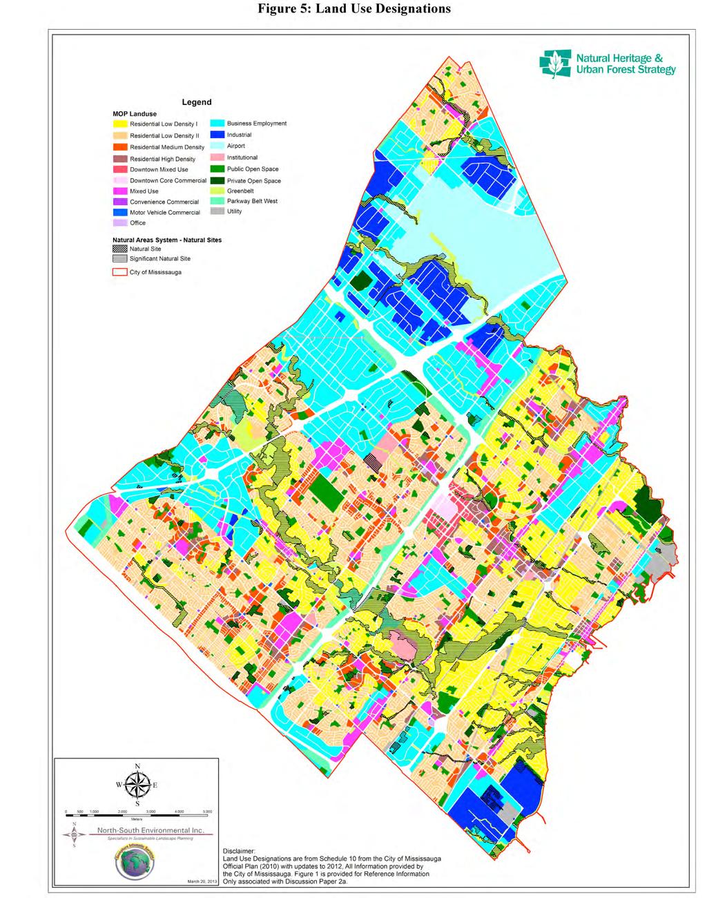
8 The letter requested that the amendment not be approved but further revisited during the 2015 Greenbelt Plan Review; however, the Province approved the proposed amendment to the Greenbelt Plan on January 9, 2013 without changes to address the above noted concerns. 4.4 CITY OF BRAMPTON On December 27, 2012, the City of Brampton staff provided preliminary comments to the Ministry of Municipal Affairs and Housing on the Proposed Amendment #1 to the Greenbelt Plan. Their comments raised the following issues with the proposed amendment: Adopting the Protected Countryside designation and policies, including those of the Natural Heritage System, in an urban area may not be appropriate. The Protected Countryside designation and policies are intended for rural areas would permit uses (i.e. agriculture and aggregate operations) that are not permitted by current Official Plan policies, and may also affect the provision of municipal infrastructure and services necessary to support a growing city. [Staff is] concerned that if the Greenbelt polices are not clarified, urban municipalities would not be able to regulate land uses in accordance with existing Official Plan policies. More detail on what policies and/or technical criteria, including requirements to delineate [Urban River Valley] lands, would be recommended prior to the adoption of the amendment. It would be appropriate to consider amending the 2008 Greenbelt expansion criteria #2 and #4, and include criteria specific to [Urban River Valleys] to clearly identify that for urban areas the Protected Countryside policies do not apply. [Staff] questions[s] the land use planning merits of adding the jurisdiction of a Provincial plan to the urban area of the City. Currently Brampton's Official Plan, comprehensive zoning by-law and conservation regulations, combined with the Region of Peel Official Plan and conservation authority regulations ensure protection of the ecological features and functions found within the valley systems, both within and outside of the Greenbelt. City staff questions whether it is necessary to proceed with a limited and scoped amendment to the Greenbelt Plan at this time in advance of the more comprehensive review in A staff report to the Planning, Design and Development Committee dated January 25th, 2013, discussed the Greenbelt Plan Amendment and the staff comments to the Ministry of Municipal Affairs and Housing. In the staff report, staff highlighted that each time an Urban River Valley designation is considered in the City, there will be a cost to map the entity and present the proposal to the public. Furthermore, because the Urban River Valley designation applies only to publically owned lands, this will result in fragmented mapping to demonstrate the external valley connections in the Greenbelt. The staff report also indicated that the City of Brampton is currently preparing a Natural Heritage and Environmental Management Strategy, and as part this ongoing process, the viability of growing the Greenbelt through the Urban River Valley designation will be considered. 5.0 IMPLICATIONS FOR MISSISSAUGA 5.1 STATUS OF THE CREDIT RIVER AND ETOBICOKE CREEK CORRIDORS As shown on Schedule 1, Urban System, of the Mississauga Official Plan (MOP), the entirety of the Etobicoke Creek and Credit River corridors are identified as part of the Green System (see Figure 2 of this report). As shown on Schedule 3 of the MOP, the Green System along these corridors is composed of lands in the City s Natural Areas System, and Natural Hazards (see Figure 3 of this report). Within the Natural Areas System, the majority of the lands along the valleys are comprised of Natural Areas along with two large Provincially Significant Wetlands. 6
9 The Natural Areas and Natural Hazard policies in the MOP ensure that, for the most part, development will not be permitted within the Credit River and Etobicoke Creek valleys. The policies in the MOP (section 6.3.1) state that development and site alteration will not be permitted within or adjacent to lands in the Natural Areas System unless it is demonstrated, through an Environmental Impact Study, that there will be no negative impacts on natural features or their ecological functions. The Natural Hazard Lands policies in the MOP (section 6.3.2) indicate that development and site alteration will generally not be permitted, and that these lands will be designated Greenbelt in the MOP. Schedule 4 further illustrates that a significant proportion of the corridors are recognized as Public and Private Open Space (see Figure 4 of this report). The Public Open Space designation provides an illustration of some of the public lands that could be included in the Urban River Valley designation of the Greenbelt Plan. Schedule 10 of the MOP (see Figure 5 of this report) illustrates the land use designations along the Credit River and Etobicoke Creek corridors. As shown on the map, the majority of the stream corridors are designated Greenbelt in the MOP. Other land use designations include Private and Public Open Space, Parkway Belt West and Institutional. These land use designations, for the most part, provide for a narrow range of permitted uses such as conservation, passive recreation, municipal infrastructure and parks. In addition to the policy protection for the valley lands within the MOP, the Region of Peel Official Plan identifies regionally significant Core Valley and Stream Corridors in Peel. Both the Credit River valley and the Etobicoke Creek valley are Core Areas in the Region s Greenlands System. The Region of Peel Official Plan prohibits development and site alteration within Core Areas, which provides for another layer of policy protection for lands within these valleys. Figure 6 of this report identifies the amount of lands within these two stream corridors that are currently publicly owned. Since there is no definition in the Greenbelt Plan of what the boundary of an Urban River Valley should be, the crest of the valley slope was used as a determinative of the boundary of the river valleys. Provincial staff have confirmed that it is up to each local municipality to determine what the extent of the Urban River Valley designation should be on either side of the valley. Figure 6 identifies all City, Peel Region, CVC, TRCA and Provincial owned lands within that area. Publicly owned lands within the Credit River valley total 466 ha with an additional 116 ha of publicly owned lands abutting the Credit River valley. Within the Etobicoke Creek valley (within Mississauga), publicly owned lands total 146 ha with an additional 99 ha of publicly owned lands abutting the Etobicoke Creek valley. A breakdown of ownership of these lands is contained in Appendix A. As noted in Section 2.3 of this report, Amendment #1 only facilitates the addition of publicly owned lands. As one can see on this map, the publicly owned lands along the Credit River and Etobicoke Creeks are not continuous and thus any resulting Urban River designation will be scattered and not continuous. The Council direction for this study was to assess the City and CVC owned lands for inclusion into the Provincial Greenbelt. Figure 6 also shows Peel Region owned lands in the Credit River valley and TRCA owned lands in the Etobicoke Creek valley. If the City were to recommend inclusion of the publicly owned land within the Greenbelt Plan Urban River Valley designation, it would be advantageous to include as much publicly owned land as possible in order to move towards a connected designation. Where the Credit River crosses Highway 403, there are lands within the Credit River Valley that are part of the Parkway Belt West Plan. There are Provincially owned lands within the Parkway Belt West Plan. The Greenbelt Plan states, in Section 2, that it encompasses the lands within the Oak Ridges Moraine area and the Niagara Escarpment Plan area and the Parkway Belt West Plan Area. Where lands are within the Parkway Belt West Plan Area and the Greenbelt Plan area, the requirements of the Parkway Belt West Plan Area continue to apply with the exceptions of Sections 3.2 (Natural System) and 3.3 (Parkland Open Space and Trails) of the Greenbelt Plan, which would apply. As such, the lands in the Parkway Belt West Plan Area could also be included in the Urban River Valley designation in the Greenbelt Plan. 7
10 However, the Province has indicated that some or all of these Provincial owned lands may be required for infrastructure purposes. 5.2 PROS AND CONS OF EXTENDING THE GREENBELT A number of municipalities have previously identified valid planning issues with expanding the Greenbelt Plan into the urban areas due to the rural focus of the Greenbelt Plan. The Province has attempted to address those shortcomings with the new Urban River Valley designation in the Greenbelt Plan. The implications and benefits of this new Urban River Valley designation for the City include: No policy duplication. With this Urban River Valley designation, there would be no duplication in policy as the City s Official Plan policies and the City s zoning would govern the use of the lands. No rural bias. The original concerns by many municipalities that a largely rural based policy structure inherent in the policies of the Greenbelt Plan would not be appropriate in an urban system, is no longer an issue as none of the Countryside policies would apply in the Urban River Valley designation. Effect on operations or maintenance of City properties Since the Urban River Valley designation in the Greenbelt Plan will rely on the City s official plan policies and designations, no additional restrictions will be placed on the City s use of their lands. However, the City s actions will have to be in conformity with Section 3.3 of the Greenbelt Plan on parkland, open space and trails. The most significant implication will be on the preparation of municipal parkland and trail strategies, which will have to have regard for the consideration of Section and However, many of these considerations would be addressed in municipal parkland and trail strategies in any event. Effect on infrastructure in the river valleys. Policy of the Greenbelt Plan addresses infrastructure in the Urban River Valley designations and states that all existing, expanded or new infrastructure approved under the Environmental Assessment Act or similar approval is permitted provided it supports the needs of the adjacent urban areas and supports the goals and objectives of the Greenbelt Plan. Effect on other City Strategies. Since the use and development of the lands in the Urban River Valleys are to be governed by the policies of the Mississauga Official Plan while having regard to the policies of Section 3.3 of the Greenbelt Plan, there is unlikely to be an effect positively or negatively on the City strategies including natural heritage strategy, infrastructure or parks planning. Including parts of the Credit River and Etobicoke Creek Valleys in the Greenbelt Plan would have some benefits to the City (although these would be more related to promotion and outreach than planning) including: Increasing the profile of the lands subject to the Urban River Valley designation by including them in a Provincial Plan; Raising awareness of the need to protect the Urban River Valleys as part of a natural heritage system; Raising awareness and providing educational opportunities on the importance of the regional linkages and the role of the Urban River Valleys as a natural heritage system and their role in linking the large core areas in the upper reaches of the watershed to Lake Ontario; and Promoting the City as the first municipality to request a Greenbelt expansion in the urban area. 8
11 However, simply including the lands on a map as part of a Provincial Plan will not increase the profile or raise awareness, it would also require promotion by the City or other public or non-governmental organizations. Additional efforts at public education will be needed to increase the profile and raise awareness, but the inclusion of the lands in the Provincial Plan could provide the rationale to do so. Provincial staff indicated that there are no financial resources available from the Province to assist in promotion or education. However, the Greenbelt Foundation may be able to assist in such promotion and outreach.. Despite these benefits, there are a number of weaknesses with the new Urban River Valley designation. These include: There are no changes to the level of policy protection; The permitted uses and level of protection defers to the local official plan polices other than the general Parkland, Open Space and Trail policies of Section 3.3 of the Greenbelt Plan. From the City s operational perspective, however, there appears to be no implications for or infringements on the City s use and management of their parks, open spaces and infrastructure as they are to be governed by the policies in the current municipal official plan. It only applies to publicly owned lands; In Mississauga, the publicly owned river valleys are already protected through public ownership and zoned as either Greenbelt or Open Space. Nothing is gained from the perspective of increasing the amount of protected lands as no additional lands would be protected in public ownership. The lands to be protected will be scattered and non-contiguous; By excluding privately owned lands and only including publicly owned lands, the lands protected in the Urban River Valley designation will be scattered and non-contiguous. Although this noncontiguous approach will not address ecological connectivity through the Greenbelt Plan alone, the non-publicly owned river valley lands are otherwise protected through the Region s and the City s Official Plans and thereby the ecological connectivity would be achieved. Survey Details are Required to bring Parcels into the Greenbelt Plan at a cost to the City; The boundary of all lands within the Greenbelt Plan are surveyed so that the exact boundaries are known. The Urban River Valley addition to the Greenbelt Plan Area in North Oakville was added through regulation with a surveyed line. The Province has confirmed that any future lands added to the Urban River Valley designation will need to follow a similar process with a surveyed line. However, the Province indicated that existing survey PINS and detailed GIS meets and bounds may suffice. However, if the City chose to include only a portion of a property into the Urban River Valley designation in the Greenbelt Plan, the dividing line between the two portions would need to be surveyed. The cost of providing the survey details will be a cost to the City, but due to the number of properties involved, it is not possible, at this time, to determine the extent of that cost. The Province clarified that the boundaries of the Greenbelt Urban River Valley designation on either side of the River Valleys are up to the municipality. The City could chose to include only that portion of their public lands that fall below the top-of-bank, or the City could chose to also include the adjacent table land portion of their public lands. The Province, however, cautioned that the City may not want to include publicly owned lands that are used for active recreation and where the City may want to intensify those active recreational uses as such uses may not be compatible with the future vision for the Greenbelt Plan Area. 9
12 Additional lands purchased by public authorities can be brought into the Greenbelt Plan but through a new Amendment Process. Additional lands purchased by the public authorities would further enhance the connectivity of the urban river valleys. However, the Province has indicated that any future expansions to include additional public lands would have to go through the same process with an amendment required to the Greenbelt Plan boundary. Undertaking repeated requests by the Region to the Province would be onerous and time consumptive of staff resources. 5.3 CRITERIA TO EXPAND THE GREENBELT To include the lands within the Greenbelt Plan, the request must come from the Region of Peel based on a demonstration that the Province s six criteria for expanding the Greenbelt can be met. Criteria 1: The request must be made by the Region of Peel and must demonstrate that the municipality has undertaken appropriate consultation with key stakeholders, public bodies, and Aboriginal communities. This engagement process would need to be undertaken and documented, and would be a cost to the City and Region. Criteria 2: The expansion is to be located adjacent to the Greenbelt or demonstrates a clear functional relationship. By selecting only publicly owned lands, a patchwork will be created and as a result, many of the parcels will not be located adjacent to the Greenbelt. However, they would have functional relationship to the Greenbelt by virtue of being within a stream corridor that connects north to the Greenbelt Plan Area. As well, coordination with the City of Brampton and the City of Toronto (along Etobicoke Creek) would be needed to ensure a fully connected Urban River Valley designation. However, Provincial staff have indicated that the City of Mississauga could bring their publicly owned lands into the Urban River Valley designation without the need for either the City of Brampton or the City of Toronto to include their publicly owned lands. Criteria 3: The request is to show how it meets the intent of the visions and one or more goals of the Greenbelt Plan. The vision of the Greenbelt Plan is to give permanent protection to the natural heritage system and the goals are to protect and restore connections between Lake Ontario, the Oak Ridges Moraine, the Niagara Escarpment and the major river valleys. While in theory this vision and the goals will be furthered, this vision and the goals are being achieved today as the lands are already protected in public ownership and are protected through Official Plan policies and zoning by-laws associated with the green system, including the existing natural heritage system (and enhanced by the proposed recommendations of the ongoing NH&UFS). However, Provincial staff indicated that a further benefit is the permanence of the Greenbelt Plan designation. Criteria 4: One or more of the Greenbelt systems are identified. The lands along the Credit River and Etobicoke Creek would be part of the Greenbelt Natural Heritage System, but it is important to recognize that a continual natural heritage system would not be created through this designation, as privately owned lands in the river valleys would not be included. Criteria 5: The proposed area for expansion cannot impede the implementation of the Growth Plan. The lands are already designated for environmental protection and are in public ownership so there should be no impact on the Growth Plan. Criteria 6: The request cannot undermine provincial interests or other provincial initiatives. Since the Urban River Valley designation applies only to public owned lands that are already protected from development, it is unlikely that it would affect any other provincial initiatives. 10
13 6.0 CONCLUSION The Province, in 2008, set out a process and criteria for expanding the Greenbelt Plan Area. A number of largely urban municipalities investigated the potential. The City of Mississauga supported in principle the addition of publicly owned lands in the Credit River Valley subject to staff undertaking a feasibility analysis of adding public lands in the Credit River Valley to the Greenbelt. Other municipalities found that the policy framework in the Greenbelt Plan was not conducive to being applied in an urban setting. The Province responded with Amendment #1 to the Greenbelt Plan approved in January This amendment was intended to address some of the short-comings of applying the Greenbelt Plan to urban areas as identified by other municipalities and introduced a new Urban River Valley designation in the Greenbelt Plan. From our review of the new Urban River Valley designation, there would appear to be no policy-related benefits from expanding the Urban River Valley designation into Mississauga and including publicly owned lands into this designation as it will not result in any increased protection of natural heritage features. There may also be costs associated with implementing the designation including potential survey requirements and the costs of consultation and report preparation, although these costs are not certain at this time. However, including parts of the urban river valleys into the Greenbelt Plan would offer benefits including elevating the profile of the lands through their inclusion in a Provincial Plan, and raising awareness of the role of the urban river valleys in supporting connection to a larger, regional natural heritage system. This discussion paper concludes that it is feasible to expand the boundaries of the Greenbelt Plan into the City of Mississauga using the new Urban River Valley designation of the Greenbelt Plan. It is recommended that, with the benefit of this Discussion Paper on the feasibility analysis, the City make a final decision on whether it is desirable to expand the Greenbelt Plan into the City. If the City chooses to request the Greenbelt Plan expansion, the Provincial process for including publicly owned lands in the Urban River Valley designation entails consultation with the public, agencies and Aboriginal groups. It is recommended that the City, Region and Province agree on the scope and extent of that consultation before proceeding. The Province also requires the City to complete, and provide to the Region of Peel, a detailed justification report, demonstrating that the 6 criteria, outlined in Section 5.3 above, can be met,. The Province further requires a resolution from both the City and Regional Councils requesting the Greenbelt Plan expansion. Allocation of City of Mississauga resources (staff costs) will be necessary to carry out the appropriate consultation and required reporting. 11

14 Figure 1: Greenbelt in Peel Region
15 Figure 2: Mississauga Official Plan Schedule 1 Urban System
16 Figure 3: Mississauga Official Plan Schedule 3 Natural System
17 Figure 4: Mississauga Official Plan Schedule 4 Parks and Open Space
18
19
20 Appendix A: Ownership breakdown on Public lands Credit River Owner Within Credit River (ha) Abutting Credit River (ha) City of Mississauga ha ha Credit Valley Conservation Authority (CVC) ha ha Toronto and Region Conservation Authority (TRCA) 0 0 Region of Peel ha 0.08 ha Lands in Provincial PWBWP 7.44 ha 5.24 ha TOTAL ha ha Etobicoke Creek Owner Within Etobicoke Creek (ha) Abutting Etobicoke Creek (ha) City of Mississauga ha ha Credit Valley Conservation Authority (CVC) ha ha Toronto and Region Conservation Authority (TRCA) ha ha Region of Peel 0 0 Lands in Provincial PWBWP 0.40 ha 0.55 ha TOTAL ha ha Source: City of Mississauga, CVC, TRCA, Region of Peel. Important Note: Area calculations are preliminary and approximate. Data are provided for discussion purposes only.
THE GREENBELT ACT AND PLAN
 Ontarians have come to value the Greenbelt since it was created in February 2005. It protects 1.8 million acres of environmentally sensitive and agricultural land around the Greater Golden Horseshoe. Growing
TERRESTRIAL NATURAL HERITAGE SYSTEM STRATEGY APPENDIX F: MODEL POLICIES FOR THE IMPLEMENTATION OF THE TARGET TERRESTRIAL NATURAL HERITAGE SYSTEM
 TERRESTRIAL NATURAL HERITAGE SYSTEM STRATEGY APPENDIX F: MODEL POLICIES FOR THE IMPLEMENTATION OF THE TARGET TERRESTRIAL NATURAL HERITAGE SYSTEM C H A P T E R 1 M O D E L P O L I C I E S F O R I M P L
CONSULTING SERVICES FOR THE WHITEBELT VISIONING EXERCISE ADDENDUM TO THE GTA WEST LAND USE STUDY WORK PROGRAM
 CONSULTING SERVICES FOR THE WHITEBELT VISIONING EXERCISE ADDENDUM TO THE GTA WEST LAND USE STUDY 1. Introduction WORK PROGRAM The Town of Caledon is a large, local municipality located in the Greater Toronto
Peel Region. Greenbelt Plan Conformity. Plan Review. Background & Approach
 Peel Region Plan Review Background & Approach Greenbelt Plan Conformity November 2008 Page 2 of 13 2 COMMENT SHEET Region of Peel Greenbelt Plan Policy Review This comment sheet is to be used to provide
9 CITY OF VAUGHAN OFFICIAL PLAN AMENDMENT NO BOCA EAST INVESTMENTS LIMITED
 9 CITY OF VAUGHAN OFFICIAL PLAN AMENDMENT NO. 631 - BOCA EAST INVESTMENTS LIMITED The Planning and Economic Development Committee recommends the adoption of the recommendations contained in the following
3-2 Environmental Systems
 3-2 Environmental Systems 3.0 ENVIRONMENTAL SYSTEMS CONTENTS 3.1 GREENWAY SYSTEM 3.1.1 General Policies 3.1.2 Natural Heritage Network 3.1.3 Natural Heritage Network Enhancement Lands 3.1.4 Rouge Watershed
APPENDIX I Presentations
 APPENDIX I Presentations Workshop Summary Report 11 Peel Region Official Plan Review May 5, 2010 Compatible Active Recreation Workshop July 29, 2010 Components of PROPR Sustainability Planning Tools/Updates
THE REGIONAL MUNICIPALITY OF PEEL BY-LAW NUMBER
 - 1 - THE REGIONAL MUNICIPALITY OF PEEL BY-LAW NUMBER 34-2010 A by-law to adopt Regional Official Plan Amendment Number 24 to the Region of Peel Official Plan in order to amend policies related to Growth
The protection of the agricultural resources of the Province;
 PART II INTRODUCTION An Official Plan is a policy document, which is intended to serve as the basis for making land use decisions and managing change in any municipality in Ontario. According to the Planning
MAYFIELD WEST SECONDARY PLAN PHASE 2
 MAYFIELD WEST SECONDARY PLAN PHASE 2 Public Open House #3 February 25, 2010 Draft Preferred Land Use Scenario TOWN OF CALEDON PLANNING & DEVELOPMENT DEPARTMENT Open House Agenda TOWN OF CALEDON 1. Welcome
1 Introduction. Chapter. In this chapter:
 Chapter 1 Introduction In this chapter: 1.1 A Snapshot of the Region 1.2 Towards a Sustainable Region 1.3 The Provincial Context 1.4 Purpose and Organization The Regional Municipality of York Official
Township of Adjala-Tosorontio Official Plan Review. Natural Heritage
 Township of Adjala-Tosorontio Official Plan Review 13 Natural Heritage Introduction What is an Official Plan? An official plan is a municipal policy document which sets out the community s vision and strategies
PDS June 1, 2016 Page 1. Planning and Development Committee. MEETING DATE: Wednesday, June 01, 2016
 Page 1 REPORT TO: Planning and Development Committee MEETING DATE: Wednesday, June 01, 2016 SUBJECT: ROPA 12: Project Initiation Report Regional Official Plan Amendment (ROPA # 12) Watercourse Policies
MAYFIELD WEST SECONDARY PLAN PHASE 2
 MAYFIELD WEST SECONDARY PLAN PHASE 2 Council Information Workshop February 16, 2010 Draft Preferred Land Use Plan TOWN OF CALEDON PLANNING & DEVELOPMENT DEPARTMENT Workshop Agenda TOWN OF CALEDON 1. Welcome
Cc~tporate Sers~ic:es
 tg * Cc~tporate Sers~ic:es Csrmcil and Adnrirristrativs Services April 26,201 1 ". RE(;lr?N (1;. 1q.1 i Town of Caledon Region of Peel ci E~iliS DEP? Attn: Karen Landry, Director of Attn: Carol Reig, Regional
APPENDIX F: EXTERNAL APPROVALS
 1.0 RESPONSIBILITIES When the City is constructing the Park or Open Space Development lands (OPTION I), after the subdivision construction process is completed by the Developer, Open Space Development
APPENDIX L3. Table of Contents. SWP EA Information Sheets
 E N V I R O N M E N T A L A S S E S S M E N T APPENDIX L3 SWP EA Information Sheets Table of Contents EA Info Sheet 1... L3-1 EA Info Sheet 2... L3-3 EA Info Sheet 3... L3-5 EA Info Sheet 4... L3-7 SCARBOROUGH
Infrastructure, Development and Enterprise Services. Natural Heritage Action Plan (NHAP) Project Initiation
 Project Initiation") Staff Report To Service Area Committee of the Whole Infrastructure, Development and Enterprise Services Date Monday, March 6, 2017 Subject Natural Heritage Action Plan (NHAP) Project Initiation Report
Staff Report To Service Area Committee of the Whole Infrastructure, Development and Enterprise Services Date Monday, March 6, 2017 Subject Natural Heritage Action Plan (NHAP) Project Initiation Report
AMENDMENT NO. 30 TO THE OFFICIAL PLAN OF THE TOWN OF MILTON
 AMENDMENT NO. 30 TO THE OFFICIAL PLAN OF THE TOWN OF MILTON Subject: Boyne Survey Secondary Plan and Related Official Plan Amendments The following text and schedules constitute Amendment No. 30 to the
COMMUNITY SUSTAINABILITY AND ENVIRONMENTAL MASTER PLAN IMPLEMENTATION UPDATE
 Attachment 1 COMMUNITY SUSTAINABILITY AND ENVIRONMENTAL MASTER PLAN IMPLEMENTATION UPDATE Priorities and Key Initiatives Committee May 2013 Page E-1 How we grow Goal 2: To ensure sustainable development
Background Summary Report
 Background Summary Report May 2014 Submitted by Macaulay Shiomi Howson Ltd. In association with AMEC MMM Group Brook McIlroy Inc. Hemson Consulting Ltd. Table of Contents 1. Introduction... 1 2. Why is
Regional Context Statement
 Regional Context Statement REGIONAL CONTEXT STATEMENT 3. REGIONAL CONTEXT STATEMENT In 1995, the Provincial Government passed into law the Growth Strategies Act. The purpose of this provincial initiative
6 Growth Management Challenges and Opportunities
 6 Growth Management Challenges and Opportunities The Town has established a goal of attaining a 50% participation rate with respect to employment opportunities versus residential population. The Town s
Planning and Growth Management Committee. Chief Planner and Executive Director, City Planning Division. Pg12013 (File No NNY 34 OZ)
") 865 York Mills Road Official Plan Amendment Application Preliminary Report STAFF REPORT ACTION REQUIRED Date: February 28, 2012 To: From: Wards: Reference Number: Planning and Growth Management Committee
865 York Mills Road Official Plan Amendment Application Preliminary Report STAFF REPORT ACTION REQUIRED Date: February 28, 2012 To: From: Wards: Reference Number: Planning and Growth Management Committee
Report to: Development Services Committee Report Date: April 24, 2017
 SUBJECT: Cornell Rouge National Urban Park Gateway - Report on Design Charrette and Next Steps PREPARED BY: Lilli Duoba, MES, MCIP, RPP, Manager, Natural Heritage (ext. 7925) REVIEWED BY: Marg Wouters,
Summary of Changes for the Comprehensive Draft Proposed Official Plan Amendment
 Summary of Changes for the Comprehensive Draft Proposed Official Plan Amendment Note: Due to the broad scope of the Official Plan Review, this list is not exhaustive of the extent of changes in the comprehensive
The West Vaughan Employment Area Secondary Plan Policies
 Part 2: The West Vaughan Employment Area Secondary Plan Policies 2.1 General Policies It is the policy of Council: 2.1.1. That the West Vaughan Employment Area (the WVEA), identified on Schedule 1, will
VILLAGE OF BOLTON HERITAGE CONSERVATION DISTRICT PLAN
 Page 1 1. INTRODUCTION AND BACKGROUND 1.1 THE PROJECT VILLAGE OF BOLTON HERITAGE CONSERVATION DISTRICT PLAN TERMS OF REFERENCE The Town of Caledon (Town) is a large, predominantly rural municipality with
CITY OF VAUGHAN EXTRACT FROM COUNCIL MEETING MINUTES OF NOVEMBER 15, 2016
 Item 11, Report No. 38, of the Committee of the Whole, which was adopted without amendment by the Council of the City of Vaughan on November 15, 2016. Regional Councillor Di Biase declared an interest
THE CORPORATION OF THE CITY OF WINDSOR Office of the City Solicitor Planning Department
 THE CORPORATION OF THE CITY OF WINDSOR Office of the City Solicitor Planning Department REPORT TO THE CITY OF WINDSOR PLANNING ADVISORY COMMITTEE DATE OF REPORT: August 19, 2010 SUBJECT: Official Plan
TOWN OF HALTON HILLS OFFICIAL PLAN
 TOWN OF HALTON HILLS OFFICIAL PLAN (Consolidated May 2008) Adoption Date: September 18, 2006 This office consolidation of the Town of Halton Hills Official Plan has been provided for convenience only.
13. VANDORF-PRESTON LAKE SECONDARY PLAN 13.1 INTRODUCTION
 13. VANDORF-PRESTON LAKE SECONDARY PLAN 13.1.1 Purpose 13.1 INTRODUCTION The Vandorf-Preston Lake Secondary Plan establishes the principles, objectives and general policies, as well as specific strategies
Mayfield West Phase 2 Secondary Plan Transportation Master Plan Second Addendum. Paradigm Transportation Solutions Limited
 Mayfield West Phase 2 Secondary Plan Transportation Master Plan Second Addendum Paradigm Transportation Solutions Limited June 2017 1 Introduction The Town of Caledon has previously approved an Official
MARKHAM. City of. Comprehensive Zoning By-law Project. Task 15: Review & Assessment - Hazardous Lands and Greenway April 20, 2015
 Appendix 'H' City of MARKHAM Comprehensive Zoning By-law Project Task 15: Review & Assessment - Hazardous Lands and Greenway April 20, 2015 Markham Zoning By-law Consultant Team Gladki Planning Associates,
TRCA Field Staking Protocol December 2016
 Page 1 of 6 TRCA Field Staking Protocol December 2016 This Protocol describes TRCA staff s current practice for field staking the physical top of bank, the physical toe of slope, and the limit of existing
Albion Hills Conservation Area Master Plan. Public Information Session
 Albion Hills Conservation Area Master Plan Public Information Session 1 03.25.2014 Meeting Agenda 1. Project Introduction Property History Current Use Master Plan Process 2. Draft Vision Goals and Objectives
AMENDMENT NO. 41 TO THE OFFICIAL PLAN FOR THE TOWN OF MONO
 AMENDMENT NO. 41 TO THE OFFICIAL PLAN FOR THE TOWN OF MONO This Amendment to the Official Plan for the Town of Mono, which has been adopted by the Corporation of the Town of Mono, is hereby approved in
2136 & 2148 Trafalgar Road Town of Oakville Region of Halton
 PLANNING JUSTIFICATION REPORT 2136 & 2148 Trafalgar Road Town of Oakville Region of Halton Zoning By-Law Amendment Application 2500674 Ontario Inc. November 2016 Table of Contents Page 1.0 Location/Summary
4. What are the goals of the Kawarthas, Naturally Connected project? 7. What are watersheds and why are they being used as the project boundaries?
 Frequently Asked Questions (FAQs) 1. What are Natural Heritage Systems (NHS)? 2. Why are they important? 3. Which areas of the province have undertaken NHS projects? 4. What are the goals of the Kawarthas,
Director, Community Planning, Etobicoke York District
 STAFF REPORT April 25, 2006 To: From: Subject: Etobicoke York Community Council Director, Community Planning, Etobicoke York District Refusal Report Rezoning Application 04 203855 WET 07 OZ Plan of Subdivision
THE CORPORATION OF THE TOWN OF OAKVILLE BY-LAW NUMBER
 THE CORPORATION OF THE TOWN OF OAKVILLE BY-LAW NUMBER 20012-08530 A by-law to adopt an amendment to the Official Plan of the Oakville Planning Area (Official Plan Amendment 198) Land North of Dundas Street.
GTA West Corridor Planning and Environmental Assessment Study Public Information Centre #5 ADDITIONAL ANALYSIS IN THE HALTON AREA Backgrounder
 GTA West Corridor Planning and Environmental Assessment Study Public Information Centre #5 ADDITIONAL ANALYSIS IN THE HALTON AREA Backgrounder Focus of Public Information Centre (PIC) #5: Present key findings
11. BALLANTRAE-MUSSELMAN LAKE AND ENVIRONS SECONDARY PLAN
 11. BALLANTRAE-MUSSELMAN LAKE AND ENVIRONS SECONDARY PLAN 11.1 PURPOSE The Ballantrae-Musselman Lake and Environs Secondary Plan Area includes two small existing settlement areas, Ballantrae and Musselman
SCHEDULE 'A' TO BY-LAW as Amended by AMENDMENT NO. 90 TO THE WHITBY OFFICIAL PLAN
 SCHEDULE 'A' TO BY-LAW 6413-10 as Amended by 6553-11 AMENDMENT NO. 90 TO THE WHITBY OFFICIAL PLAN SECTION A: GROWTH PLAN CONFORMITY PURPOSE: LOCATION: BASIS: The purpose of this Amendment is to: conform
OFFICIAL PLAN FOR THE TOWN OF NEW TECUMSETH
 OFFICIAL PLAN FOR THE TOWN OF NEW TECUMSETH Approved by Simcoe County- March 10, 2010 TABLE OF CONTENTS PAGE# 1.0 TITLE AND COMPONENTS... 5 2.0 INTRODUCTION... 6 2.1 Purpose... 6 2.2 Organization of the
FURTHER TO EXECUTIVE COMMITTEE MEETING #11/12 To be held on Friday, January 11, 2013
 FURTHER TO EXECUTIVE COMMITTEE MEETING #11/12 To be held on Friday, January 11, 2013 FURTHER TO: Pages EX10. APPLICATION FOR PERMITS UNDER ONTARIO REGULATION 166/06 Development, Interference with Wetlands
Planning Department. Director of Planning. Manager of Planning. Planning Technician/ Sustainability Coordinator. Planner II/ Heritage Coordinator
 Department Director of Manager of Policy Planner Planner II (2) Planner II/ Heritage Coordinator Technician/ Sustainability Coordinator Technician Administrative Clerk March 2017 Department 2018 Business
ONTARIO MUNICIPAL BOARD
 PL 120483 ONTARIO MUNICIPAL BOARD Applicant/Appellant: 2124123 Ontario Limited Subject: OPA, Rezoning and Draft Plan of Subdivision Municipal Address: 3940 Highway 7 East Municipality: City of Markham
NEW REGIONAL OFFICIAL PLAN HIGH LEVEL PROCESS & FRAMEWORK
 NEW REGIONAL OFFICIAL PLAN HIGH LEVEL PROCESS & FRAMEWORK Why A New Official Plan Originally the role of Regionally Planning and content of Regional Official Plan (1970s) primarily focused on protecting
8 Oak Street - Official Plan and Zoning By-law Amendment Application - Preliminary Report
 STAFF REPORT ACTION REQUIRED 8 Oak Street - Official Plan and Zoning By-law Amendment Application - Preliminary Report Date: March 17, 2014 To: From: Wards: Reference Number: Planning and Growth Management
Employment and Commercial Review Analysis of Policy Directions
 Employment and Commercial Review Analysis of Policy Directions Appendix A The following analysis is town staff s response to the policy directions provided by the consultants who prepared the Employment
Rowntree Mill Road Zoning and Plan of Subdivision Applications Final Report
 STAFF REPORT ACTION REQUIRED 148-156 Rowntree Mill Road Zoning and Plan of Subdivision Applications Final Report Date: March 13, 2007 To: From: Wards: Reference Number: Etobicoke York Community Council
Central Lake Ontario Conservation Conservation Lands Master Plan
 Conservation Lands Master Plan Top 13 Frequently Asked Questions 1. What are conservation lands? Where are these conservation lands located in the Central Lake Ontario Conservation watershed? Conservation
CITY OF VAUGHAN EXTRACT FROM COUNCIL MEETING MINUTES OF DECEMBER 10, 2013
 Item 1, Report No. 55, of the Committee of the Whole (Working Session), which was adopted without amendment by the Council of the City of Vaughan on December 10, 2013. Regional Councillor Di Biase declared
Environment and Sustainability. Environment and Sustainability
 4 Environment and Sustainability Environment and Sustainability ENVIRONMENT AND SUSTAINABILITY 4.1 CLIMATE CHANGE AND AIR QUALITY... 4-5 4.1.1 OBJECTIVES... 4-6 4.1.2 POLICIES... 4-6 4.2 NATURAL HERITAGE
THE STRUCTURE OF THE PLAN...
 TABLE OF CONTENTS THE STRUCTURE OF THE PLAN... 1 A1 THE COMMUNITY VISION... 3 A2 GOALS AND OBJECTIVES... 3 A2.1 THE NATURAL ENVIRONMENT... 3 A2.1.1 Goal... 3 A2.1.2 Objectives... 3 A2.2 GROWTH AND SETTLEMENT...
Elfrida Growth Area Study
 Elfrida Growth Area Study Public Information Centre #2 December 6, 2017 6:00-8:30 pm PLANNING & ECONOMIC DEVELOPMENT DEPARTMENT Purpose of the Study The Elfrida Area has been identified as the preferred
1.0 PLANNING MARKHAM S FUTURE CONTENTS
 1-1 Planning Markham s Future 1.0 PLANNING MARKHAM S FUTURE CONTENTS 1.1 THE PURPOSE OF THE OFFICIAL PLAN 1.2 THE MARKHAM CONTEXT 1.3 THE REGULATORY CONTEXT 1.3.1 Province of Ontario 1.3.2 York Region
Tel ooo Telec
 Office of the Minister Bureau du ministre 12 The four proposed revised plans, a guide to the proposed changes to the plans -- Shaping Land Use in the Greater Golden Horseshoe, as well as information on
11.4 Highway 400 North Employment Lands Secondary Plan APPROVED BY THE ONTARIO MUNICIPAL BOARD ON NOVEMBER 21, 2011
 11.4 Highway 400 North Employment Lands Secondary Plan APPROVED BY THE ONTARIO MUNICIPAL BOARD ON NOVEMBER 21, 2011 11.4.1 General 11.4.1.1. as approved by the Ontario Municipal Board on November 21, 2011,
SPECIAL COMMITTEE OF THE WHOLE DECEMBER 9, 2002 BLOCK 57/58 WEST BLOCK PLAN BLOCK PLAN FILE BL.57/58W.99 HUNTINGTON BUSINESS PARK LAND OWNERS
 SPECIAL COMMITTEE OF THE WHOLE DECEMBER 9, 2002 BLOCK 57/58 WEST BLOCK PLAN BLOCK PLAN FILE BL.57/58W.99 HUNTINGTON BUSINESS PARK LAND OWNERS Recommendation The Commissioner of Planning recommends: THAT
2.5.1 Mineral aggregate resources shall be protected for long-term use
 2.5 MINERAL AGGREGATE RESOURCES 2.5.1 Mineral aggregate resources shall be protected for long-term use 2.5.2 Protection of Long-Term Resource Supply 2.5.2.1 As much of the mineral aggregate resources as
~!VAUGHAN NOV Z November 21, Mr. Denis Kelly, Regional Clerk The Regional Municipality of York Yonge Street Newmarket, ON L3Y 6Z1
 ~!VAUGHAN NOV Z 5 2016 November 21, 2016 Mr. Denis Kelly, Regional Clerk The Regional Municipality of York 17250 Yonge Street Newmarket, ON L3Y 6Z1 Dear Mr. Kelly: RE: NEW KIRBY GO STATION IN BLOCK 27
12 AMENDMENT NO. 149, TOWN OF MARKHAM HIGHWAY 404 NORTH SECONDARY PLAN
 12 AMENDMENT NO. 149, TOWN OF MARKHAM HIGHWAY 404 NORTH SECONDARY PLAN The Planning and Economic Development Committee recommends the adoption of the recommendation contained in the following report August
10 Park Lawn Rd - Zoning Amendment Application- Preliminary Report
 STAFF REPORT ACTION REQUIRED 10 Park Lawn Rd - Zoning Amendment Application- Preliminary Report Date: March 9, 2012 To: From: Wards: Reference Number: Etobicoke York Community Council Director, Community
Second Line West Pedestrian/Cyclist Crossing of Highway 401 Class EA. Second Line West Pedestrian/Cyclist Crossing of Highway 401 Class EA
 1 1 Purpose of Public Information Centre #2 To provide interested and/or potentially affected stakeholders with an opportunity to participate in the planning and decision-making process for this Municipal
Services Department B September 10, 2007
 Report To: Development Services Committee Item: Date of Report: DS-07-246 September 5, 2007 From: Commissioner, Development File: Date of Meeting: Services Department B7200-0001 September 10, 2007 Subject:
PUBLIC OPEN HOUSE HURONTARIO-MAIN CORRIDOR SECONDARY PLAN
 PUBLIC OPEN HOUSE HURONTARIO-MAIN CORRIDOR SECONDARY PLAN Tuesday, February 28, 2012 6pm 9pm 1 st Floor Atrium, City Hall 2 Wellington Street West, Brampton 1 POLICY FRAMEWORK The 2006 Provincial Growth
Report to: Development Services Committee Report Date: September 11, 2017
 ~RKHAM Report to: Development Services Committee Report Date: September 11, 2017 SUBJECT: PREPARED BY: Conceptual Master Plan for the Future Urban Area - Community Structure Plan and Key Policy Direction
RECOMMENDED DIRECTIONS REPORT FOR THE TOWN OF RICHMOND HILL
 RECOMMENDED DIRECTIONS REPORT ENVIRONMENTAL POLICY REVIEW FOR THE TOWN OF RICHMOND HILL Prepared for: Town of Richmond Hill 225 East Beaver Creek Road Richmond Hill, ON, L4B 3P4 Prepared by: SENES Consultants
3 TOWN OF WHITCHURCH-STOUFFVILLE OFFICIAL PLAN AMENDMENT NOS. 116 & 117
 3 TOWN OF WHITCHURCH-STOUFFVILLE OFFICIAL PLAN AMENDMENT NOS. 116 & 117 The Planning and Economic Development Committee recommends the adoption of the recommendations contained in the following report,
Edward R. Sajecki Commissioner of Planning and Building
 Corporate Report Clerk s Files Originator s Files CD.03.POR DATE: TO: FROM: SUBJECT: Chair and Members of Planning and Development Committee Meeting Date: February 27, 2012 Edward R. Sajecki Commissioner
Synopsis of 50 years of Planning in the Greater Golden Horseshoe (GGH), Ontario, Canada. Olusola Olufemi 2015
, Ontario, Canada. Olusola Olufemi 2015") Synopsis of 50 years of Planning in the Greater Golden Horseshoe (GGH), Ontario, Canada Olusola Olufemi 2015 Canada Background Canada s population is 34,834,841 (July 2014 est.) Capital city: Ottawa Canada
Synopsis of 50 years of Planning in the Greater Golden Horseshoe (GGH), Ontario, Canada Olusola Olufemi 2015 Canada Background Canada s population is 34,834,841 (July 2014 est.) Capital city: Ottawa Canada
SUBJECT: Revised proposed new official plan recommended for adoption
 Page 1 of Report PB-04-18 SUBJECT: Revised proposed new official plan recommended for adoption TO: FROM: Planning and Development Committee Department of City Building Report Number: PB-04-18 Wards Affected:
Growth Area Reviews Preliminary Directions for Midtown Oakville, the Uptown Core and Palermo Village
 Growth Area Reviews Preliminary Directions for Midtown Oakville, the Uptown Core and Palermo Village Livable Oakville Council Subcommittee January 15, 2018 1 Introduction Why a study? January 2014 Signaled
Sustainable Growth. Sustainable Growth
 2 Sustainable Growth Sustainable Growth SUSTAINABLE GROWTH 2.1 COMMUNITY VISION... 2-5 2.2 THE CITY SYSTEM... 2-7 2.2.1 AREAS... 2-7 2.2.2 CITY-WIDE SYSTEMS... 2-8 2.2.3 PROVINCIAL PLAN BOUNDARIES AND
HEMSON C o n s u l t i n g L t d.
 INVENTORY & ASSESSMENT OF INTENSIFICATION OPPORTUNITIES City of Brampton Discussion i Paper for Public Review C o n s u l t i n g L t d. November 2008 EXECUTIVE SUMMARY This report is one of the key background
AMENDMENT NO. 2 TO THE TRENT HILLS OFFICIAL PLAN
 The Municipality of Trent Hills Official Plan AMENDMENT NO. 2 TO THE TRENT HILLS OFFICIAL PLAN Adopted by Council on Approved by the Ministry of Municipal Affairs and Housing on Version Date: November
SCARBOROUGH SUBWAY EXTENSION. Scarborough Subway Extension. Final Terms of Reference
 Scarborough Subway Extension Final Terms of Reference 1 1.0 Introduction and Background 1.1 Introduction Toronto City Council recently confirmed support for an extension of the Bloor-Danforth Subway from
2.0 A FRAMEWORK FOR SUSTAINABLE GROWTH CONTENTS
 2-2 A Framework for Sustainable Growth 2.0 A FRAMEWORK FOR SUSTAINABLE GROWTH CONTENTS 2.1 MANAGING SUSTAINABLE GROWTH THE VISION TO 2031 2.2 GOALS AND OBJECTIVES 2.2.1 Protecting the Natural Environment
CONTENTS 2.0 A FRAMEWORK FOR SUSTAINABLE GROWTH 2.1 MANAGING SUSTAINABLE GROWTH THE VISION TO GOALS AND OBJECTIVES 2.3 MARKHAM STRUCTURE
 2 A Framework for Sustainable Growth 2.0 A FRAMEWORK FOR SUSTAINABLE GROWTH CONTENTS 2.1 MANAGING SUSTAINABLE GROWTH THE VISION TO 2031 2.2 GOALS AND OBJECTIVES 2.2.1 Protecting the Natural Environment
An Introduction to the Far North Land Use Strategy
 An Introduction to the Far North Land Use Strategy December, 2013 Ministry of Natural Resources Table of Contents PREFACE... 3 About the Far North... 3 Evolution of Land Use Planning in the Far North...
STAFF REPORT. December 20, North York Community Council. Director, Community Planning, North York District
 STAFF REPORT December 20, 2005 To: From: Subject: North York Community Council Director, Community Planning, North York District Preliminary Report Application to Amend the Official Plan and Zoning By-law
KING CITY COMMUNITY PLAN
 KING CITY COMMUNITY PLAN TOWNSHIP OF KING JANUARY 27, 2000 AMENDMENT NO. 54 to the OFFICIAL PLAN for the TOWNSHIP OF KING PLANNING AREA THE COMMUNITY PLAN TABLE OF CONTENTS PAGE PART 1 INTRODUCTION 1.1
Bloor St. W. Rezoning - Preliminary Report
 STAFF REPORT ACTION REQUIRED 1638-1644 Bloor St. W. Rezoning - Preliminary Report Date: April 1, 2008 To: From: Wards: Reference Number: Toronto and East York Community Council Acting Director, Community
SUBJECT: GO Station Mobility Hubs Preferred Concepts: Aldershot GO, Burlington GO and Appleby GO. Planning and Development Committee - Public Meeting
 Page 1 of Report PB-76-17 SUBJECT: GO Station Mobility Hubs Preferred Concepts: Aldershot GO, Burlington GO and Appleby GO TO: FROM: Planning and Development Committee - Public Meeting Planning and Building
LU Encourage schools, institutions, and other community facilities that serve rural residents to locate in neighboring cities and towns.
 Application No. 891627: Comprehensive Plan Text Amendment - Rural School Policies - Amend policies consistent with State Legislation allowing schools in the rural area and extension of sewer service to
Preface. Erie. Scranton. Allentown. Pittsburgh. Harrisburg. Philadelphia
 The Southern Alleghenies Region The Southern Alleghenies Region spans the Laurel Highlands and Allegheny Front in the west across the Appalachians to the east. It is comprised of Blair, Bedford, Cambria,
a) recognize agriculture as the primary activity and land use; b) maintain and preserve the agricultural resource base of the Town;
 recognize agriculture as the primary activity and land use; b) maintain and preserve the agricultural resource base of the Town;") PA RT E E1 AGRICULTURAL AREA E1.1 OBJECTIVES It is the objective of this designation to: a) recognize agriculture as the primary activity and land use; b) maintain and preserve the agricultural resource
PA RT E E1 AGRICULTURAL AREA E1.1 OBJECTIVES It is the objective of this designation to: a) recognize agriculture as the primary activity and land use; b) maintain and preserve the agricultural resource
Figure 1- Site Plan Concept
 Figure 1- Site Plan Concept Parking will be provided underground on three levels at rate of 1.0 space/ unit; this rate includes all visitors parking. MMM Group has prepared a parking assessment (April,
Land Use Regional Planning in Alberta Collaborating with Stakeholders
 Land Use Regional Planning in Alberta Collaborating with Stakeholders Trevor Lema, Land & Integrated Management Planner September 2018 Overview Why Regional Planning? An Integrated Perspective Integrated
2.0 REGULATORY CONTEXT
 2.0 REGULATORY CONTEXT 2.1 CEAA and BC Parks Cooperation This Environmental Assessment Report (EAR) reflects the Terms of Reference for a Screening Report under the Canadian Environmental Assessment Act
Official Plan Review: Draft Built Form Policies
 PG.30.1 REPORT FOR ACTION Official Plan Review: Draft Built Form Policies Date: May 15, 2018 To: Planning and Growth Management Committee From: Chief Planner and Executive Director, City Planning Division
CITY OF VAUGHAN EXTRACT FROM COUNCIL MEETING MINUTES OF DECEMBER 10, 2013
 CITY OF VAUGHAN EXTRACT FROM COUNCIL MEETING MINUTES OF DECEMBER 10, 2013 Item 1, Report No. 55, of the Committee of the Whole (Working Session), which was adopted without amendment by the Council of the
13 THORNHILL YONGE STREET STUDY IMPLEMENTATION CITY OF VAUGHAN OPA 669 AND TOWN OF MARKHAM OPA 154
 13 THORNHILL YONGE STREET STUDY IMPLEMENTATION CITY OF VAUGHAN OPA 669 AND TOWN OF MARKHAM OPA 154 The Planning and Economic Development Committee recommends the adoption of the recommendations contained
North Oakville East Parks Facilities Distribution Plan. November, 2009
 North Oakville East November, 2009 POLICY CONTEXT 1) Purpose a) The purpose of this document is to be a guide for the location, configuration, design and development of the parks system for the North Oakville
Chair and Members of the Planning, Public Works and Transportation Committee. Tara Buonpensiero, Senior Planner Policy, MCIP, RPP
 REPORT TO: REPORT FROM: Chair and Members of the Planning, Public Works and Transportation Committee Tara Buonpensiero, Senior Planner Policy, MCIP, RPP DATE: April 9, 2018 REPORT NO.: RE: PLS-2018-0027
December 11, December 10, 2015
 December 11, 2015 December 10, 2015 2 Welcome & Introductions Project Overview Discussion Questions Group Insights Key Takeaways Next Steps 3 4 5 6 7 8 9 Governed by multiple layers of policy UNESCO World
CITY CLERK. Parkland Acquisition Strategic Directions Report (All Wards)
") CITY CLERK Clause embodied in Report No. 10 of the, as adopted by the Council of the City of Toronto at its meeting held on November 6, 7 and 8, 2001. 10 Parkland Acquisition Strategic Directions Report
CITY CLERK Clause embodied in Report No. 10 of the, as adopted by the Council of the City of Toronto at its meeting held on November 6, 7 and 8, 2001. 10 Parkland Acquisition Strategic Directions Report
SUBJECT: New Official Plan Review: Rural, Natural Heritage and Sustainability Policy Directions
 Page 1 of Report PB-83-16 SUBJECT: New Official Plan Review: Rural, Natural Heritage and Sustainability Policy Directions TO: FROM: Committee of the Whole Planning and Building Department Report Number: