East Harptree Site EH3 Parker s Mead, Church Lane
|
|
|
- Philip Davis
- 5 years ago
- Views:
Transcription

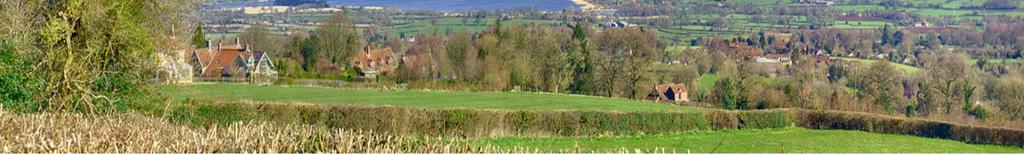
1 East Harptree Site EH3 Parker s Mead, Church Lane Photograph EH3.1 View looking north towards Chew Valley Lake Photograph EH3.2 Church Lane, adjacent to western site boundary
2 Reference Baseline Information Site Assessments Land between Middle Street and Water Street, East Harptree


3 Land off Middle Street and Water Street
4
5 Toolkit: Site Assessment FORM A: BASELINE INFORMATION Settlement Name East Harptree Core Strategy Settlement Classification RA2 Site Name / Address Land between Middle Street & Water Street, East Harptree Parish Name East Harptree ST Gross area (Hectares) Ha SHLAA Site reference N/A SHLAA Capacity Assessment N/A Current/recent uses Un-used Grassland / Orchard Availability Unknown Site Planning History Thought to have been included as part of a previous application for a larger development (c.1960 s/70 s) which was only partially completed. Planning history is pre-1996, therefore no record is held on B&NES online database of planning applications.
6 Toolkit: Site Assessment DESIGNATIONS & KNOWN CONSTRAINTS AONB YES NO Comments Site is located within Mendip Hills AONB Green Belt YES NO Comments N/A SSSI / SNCI YES NO Comments Conservation Area YES NO Comments Site is 250m from both conservation areas within the village Listed Buildings YES NO Comments Recorded Archaeology YES NO Comments Unknown Public Rights of Way YES NO Comments No public right of way crosses the site. Flood Risk YES NO Comments Site is set at a higher elevation than Middle Street & Water Street, therefore should not be at risk of flooding. Services wires & cables (if known) YES NO Comments Drainage manhole present in entrance gateway to site. Utility pole (electric) present in southwestern corner of site. Mining / Contamination Map YES NO Comments Unknown Other Known / Recorded Constraints Comments Unknown.
7 Toolkit: Site Assessment FORM B: ASSESSING SITE CONNECTIONS AND ACCESS Site: Land between Middle Street & Water Street. Surveyors(s): PK, JE, PW, SJ, JL, NJ Date: 30/11/13 Look through all the questions before starting. Leave any questions that do not seem to apply. Take a form, clipboard, map, camera and a pen or two with you when you go out. Take any photos you think are useful (often more useful than some words) and add any photo names/numbers in the right hand boxes once you get back to base. 1. WALKING TO LOCAL FACILITIES Facility Shop 300 Distance (metres) Route Quality Good Fair Poor Observations and comments on safety and quality of route Site Visit Notes/Record of Photos No pavement in places, parked cars mean pedestrians have to walk in road. No street lighting. School 300 Good Fair Poor No pavement in places, parked cars mean pedestrians have to walk in road. No street lighting. Open Space 800 Good Fair Poor (This is about publicly accessible spaces) Playing Field / Children s Play Area Route to playing field / children s play area requires crossing main road. No pavement available / No street lighting. Cars parked on pavement on High Street. Bus Stop 300 Good Fair Poor No pavement in places, parked cars mean pedestrians have to walk in road. No street lighting. There is an infrequent bus service, with very limited routes. There is no bus route to Bath, and timings of the limited services mean that residents commuting cannot travel to work on public transport. Any other facility 300 Good Fair Other facility name: Pub, Playgroup, Hairdressers, Village Club & Theatre No pavement along part of route / No street lighting. Poor
8 Toolkit: Site Assessment 2. SITE ACCESS(ES) General quality of access Good: Easy access into the site and good roads approaching it. Fair: Poor access into the site but good approach roads, or poor access into the site and good approach roads. Poor: Poor access onto the site and poor roads approaching it. Number of Accesses. Type (vehicle or pedestrian) Observations / Comments / Site Visit Notes / Record of Photos Key Issues and Possible Mitigation (if Fair or Poor) Tick one Good access into site and fair roads approaching it. Access is typical of narrow village lanes / roads. Currently a single point of access via Water Street (shared vehicular and pedestrian). (see photo EH4.3) 3. CONNECTIONS SUMMARY: Overall, how well connected is the site? Note key points in the site's favour in terms of connections. GOOD walking distance and fair route safety to shops and school. POOR pedestrian connection to playing fields / Children s play area. FAIR routes approaching the site, access maybe improved with the option of creating secondary / new access via Middle Street. Note the key points in terms of connections that would have to be addressed (mitigation) to make it a suitable site: None, although it may be possible to create a second point of access via Middle Street. This would increase connectivity of any development with the rest of the village.
9 Toolkit: Site Assessment FORM C: ASSESSING THE SITE ENVIRONMENT Site: Land between Middle Street & Water Street. Surveyors(s): PK, JE, PW, SJ, JL, NJ Date: 30/11/13 Look through all the questions before starting. For almost all the questions on Site Characteristics just ring a word (or two) in each box that best fits what you know/see and, as necessary, add some notes about quality, condition etc. in the space below. The final Summary questions include their own instructions. Leave any questions that do not seem to apply. Take a form, clipboard, map, camera and a pen or two with you when you go out. Take any photos you think are useful (often more useful than some words) and add any photo names/numbers in the right hand boxes once you get back to base. 1. SITE CHARACTERISTICS Landform: Gently sloping Observations/Notes/Record of Photos Site is at higher elevation than Middle Street and Water Street on either side of the site. Access into the site from Water Street is via a moderately steep tarmac road through an existing cul-de-sac development. The site is separated from Middle Street by a hedgerow set at the top of a steep earth bank with Middle Street below. (see photos EH ) Views In: Channelled, quite private, short, enclosed. Quality and Value of View/Record of Photos Site is quite private, and only partially overlooked from upper storeys of a limited number of properties. Views Out: Sweeping, long, exceptional view of Chew Valley Lake. Quality and Value of View/Record of Photos Site is mostly enclosed within hedges. Long views over site boundary to Chew Valley Lake and Dundry.
10 Toolkit: Site Assessment Natural Features on and Around the Site (Age/Condition/Value): Boundary Hedgerow, Trees & Grass Numbers, Quality and Value Observations/Notes/Record of Photos 3no. apple trees spread out within the site. Grass cover present across the site. Boundary hedgerow is present on 3 sides of the site (north, south, west), with some mixed deciduous semi-mature trees within hedgerow. Hedgerow is patchy in places and needs some restoration. Ecology: (Known/Observed): Birds Comments/Notes, Quality and Value Observations/Notes/Record of Photos None observed, but potentially suitable for a range of ecological habitats, due to length of time which the site has been left un-used. Built Form On and Around the Site: No walls or freestanding buildings/structures present on site. Neighbouring buildings/structures in view - partially Neighbouring use - residential Potential Conflicts none known Comments/Notes, Observations/Notes/Record of Photos Site is accessed through a development of 1960 s/70 s, individually designed chaletbungalows. These are constructed from a mixture of reconstituted stone & render. All are large properties, set within large plots in a secluded development.
11 Toolkit: Site Assessment 2. ENVIRONMENT SUMMARY Environment Quality and Value: Does the recorded information above suggest that the site is of high quality and value, or is it medium or low? High Tick one Medium Low Note key points in the site's favour in terms of environment. Hedgerow enclosed plot and private / hardly overlooked. Long, exceptional views from site across Chew Valley towards Lake Site appears to be an unfinished part of the development through which it is accessed. Some of the infrastructure is in place to complete development of this site (road to site entrance & drainage connection present). Note the key points in terms of environment that would have to be addressed (mitigation) to make it a suitable site. None
12 Toolkit: Site Assessment FORM D: OVERALL ASSESSMENT SUMMARY Site name/number: Land between Middle Street & Water Street, East Harptree Tick one The site is suitable for allocation The site is well located and has lower environmental sensitivity to change. This is a potential allocation subject to on- or off-site mitigation The site is either well located but with higher environmental sensitivity to change or poorly located but with lower environmental sensitivity to change. The site is unsuitable for allocation The site is poorly connected and has higher environmental sensitivity to change. What are the key reasons behind your final judgement? Assessors deemed it suitable as it is considered it as being the 2 nd phase of a partly developed site in an ideal, secluded position. If the site was judged to be potentially suitable, what type of development might be possible or appropriate housing, employment, facilities etc.? A modest, in-keeping, well designed development of mixed size houses would be appropriate to the size of site and the surrounding properties. If the site was judged to be potentially suitable, what mitigation might be needed to make it properly suitable? N/A If the site was judged to be suitable or potentially suitable, what principles or conditions might be applied (eg. heights, screening, materials etc.)? (Add comments on the site plan if this helps, eg. to show a key view.) The site is bounded to the north and south by traditional cottages, and to the east by individually designed 1960 s/70 s chalet bungalows. Any development would need to be sensitive to this setting. Signed.. Date... Telephone eastharptreeclerk@hotmail.co.uk


13 East Harptree Site EH4 Land between Water Street and Middle Street Photograph EH4.1 View west from access road off Water Street Photograph EH4.2 - Site Entrance Photograph EH4.3 Site Access
14 Reference BaNES Placemaking Plan Character and Site Assessment Validation
15
16 Placemaking Plan Character and Site Assessment Validation Parish Name: Date that the Placemaking Assessment was received: Policy categorization: East Harptree 30 th December 2013 Core Strategy Policy RA2
17 Stage 1: Validation All site assessments should be accompanied by a character assessment which has informed the location of the surveyed sites. Understanding the overall character of a whole Parish or Town Council area is central to securing good quality, well designed and sustainable developments. This is further supported by the National Planning Policy Framework, paragraph 58 which states new development should respond to local character and history, and reflect the identity of local surroundings and materials The character appraisal should define in detail the Parish/Town Council s built environment. This will provide evidence supporting a local policy framework that seeks to protect the best of the heritage and help encourage sympathetic developments that will be important for the Parish/Town Council s future whilst minimising harm to character. At this stage B&NES Council has reviewed whether the various elements of the character appraisal has been undertaken in accordance with the Toolkit. No comments are made by the Council at this stage regarding whether it agrees with the conclusions reached. However, where it is considered there are omissions from the character appraisal or it could be improved this is highlighted below. The following detail has been captured within the submitted character appraisal assessment: Validation Criteria A landscape description Details on the key views and landmarks Detail on the settlement patterns Information on the buildings, including materials and details Details on the sense of place Positive features and special qualities Features to be improved or detracting elements Have any natural or built environment assets been identified? Officers Comments on the Character Appraisal : No character appraisal has been received. Have any natural or built environment assets been identified? It is noted from reading the character appraisal that the Parish has many natural and built assets which should be protected. It would be beneficial if you can plot all your assets onto a map (or series of maps based on the headings below if this is
18 easier) and write a short statement explaining why the asset(s) are important. These assets will be reviewed over Summer 2014 by B&NES. Natural and built assets can be grouped into the following themes: Social and communal value Are there assets of importance to the local community? The asset(s) may be a source of civic pride for the community or a place that contributes to the collective memory of that area? Heritage value Are there assets that reflect the traditional functional character or former uses in the village? Architectural interest Are there assets that may be of a high-quality representation of a particular architectural style or type, an individually distinctive form of architecture or are there assets that demonstrate artistic interest? Associations Are there assets with a historical association with the village, with particular people, artists, writers, or other media, or events in history? Aesthetic value Are there assets which have intrinsic design value relating to local styles, materials or any other distinctive local characteristics? Landmark Quality Are there assets with a visual prominence? Assets with landmark quality are normally aesthetically attractive and dominate the street scene or an important view/vista. Assets with landmark quality are normally geographical or cultural orientation points.
19 Archaeological Interest Are there any assets of archaeological interest? Geological Interest Are there any geological landforms of interest? Scenic quality Are there assets that appeal primarily to the visual senses Conservation Are there any important flora or fauna assets which should be protected or noted? Local Green Space Designation The National Planning Policy Framework (NPPF) sets out the Government are planning policies for England. A new designation to protect local green areas of particular importance to local communities has been introduced. The Local Green Space designation will allow communities to identify and protect areas that are of value to the community through local and neighbourhood plans. Therefore, it is useful for the Parish Council to identify these local green spaces potentially for protection through the B&NES Placemaking Plan or a Parish prepared Neighbourhood Plan. It is noted that East Harptree has many green spaces which could be designated as Local Green Spaces. It should be noted however that any green spaces considered by B&NES will need to fulfil criteria set out in paragraph 77 of the NPPF: where the green space is in reasonably close proximity to the community it serves where the green area is demonstrably special to a local community and
20 holds a particular local significance, for example because of its beauty, historic significance, recreational value (including as a playing field), tranquillity or richness of its wildlife; Where the green area concerned is local in character and is not an extensive tract of land. For reference: The proximity of a Local Green Space to the community it serves will depend on local circumstances, including why the green area is seen as special, but it must be reasonably close. For example, if public access is a key factor, then the site would normally be within easy walking distance of the community served. For example, green areas could include land where sports pavilions, boating lakes or structures such as war memorials are located, allotments, or urban spaces that provide a tranquil oasis. Extensive designation of open countryside adjacent to settlements will not be appropriate. Provided land can meet the criteria at paragraph 77 of the National Planning Policy Framework there is no lower size limit for a Local Green Space.
21 Green Infrastructure Parish and town councils were asked to assess the green infrastructure assets in and around their parish. This included green spaces, footpaths and cycle ways, places of value and corridors for wildlife. This information will feed into green infrastructure profiles, with initial priority for the RA1 and RA2 designated villages. These profiles will help to inform decisions around new and existing green infrastructure, particularly in relation to new developments, and will be inform the Placemaking Plan Maps of known green infrastructure were distributed alongside a pro forma to guide this work and the results have been assessed as below: Validation Criteria Map has been annotated and comments made Networks for people: footpaths and cycle ways Networks for people: outdoor play and relaxation Networks for wildlife: green areas and corridors Multi-function and value: valued green assets Multi-function and value: green assets which could provide more value Local green space designation proposals Officers Comments on the Green Infrastructure Pro Forma : This parish has not completed a green infrastructure pro forma or character assessment so the below cannot be commented on. Green Infrastructure Map Networks for People Networks for Wildlife Multifunction and Value

22 Initial Site Assessment Through this validation process B&NES Council has reviewed the information gathered by the Parish and Town Councils for the Placemaking Plan evidence base. The site assessment information supplied by the Parish/Town Council is set out below and reviewed by category in the Toolkit. Where B&NES Council has reviewed and confirmed the information submitted is corrected it is indicated as validated. In some circumstances the supporting information may be insufficient or sections omitted. In these cases, B&NES will make comments; these comments/additional information will be clearly distinguished from the Parish/Town Council comments and will be clearly highlighted I bold in this report. Please note that no comments will be made on the suitability of the sites at this stage. During the Summer 2014, B&NES will undertake Stage 2 and will assess all sites put forward by the Parish and Town Councils for consideration in the Placemaking Plan Options Document which is due to be published in Winter Site Locations Map to show the location of surveyed sites in East Harptree. E1 E2 E3 E4 Crown Copyright and database right. All rights reserved ( ) 2014 Parish Online Map: 1:7,300
23 Current Use These comments have been collated from the site assessments submitted by East Harptree Parish Council and will be reviewed fully in Stage 2. Site Ref. Size of the site Current Use Potential contamination Validated E1 0.5 Ha Agricultural-pasture/ grazing E2 0.45Ha Agricultural-pasture/ grazing No Yes- elevated heave metals in soil (arsenic and lead) E Ha Un-used grassland/ No orchard E4 0.36Ha Farm Yard and Buildings Yes from long term agricultural practices 8
24 Relationship to Existing Built-Up Area(s) These comments have been collated from the site assessments submitted by east Harptree Parish Council and will be reviewed fully in Stage 2. Site Ref. Relationship to the existing built-up areas Officers Comments E1 Approximately 240m s to the nearest shop and approximately 275m s to the school however there are no pavements or street lighting along part of the route. Approximately 180m s to the nearest bus stop. There is easy access onto the site and there are good roads approaching the site. A transport survey and accessibility to the potential site would need to be investigated. E2 E3 Approximately 100m s to the nearest shop school and bus stop however there are no pavements or street lighting along part of the route. There is poor access into the site however the approach roads are good. There is a single point of vehicular access. A public footpath crosses the site, it links Church Lane to Middle Street. Approximately 300m s to the nearest shop school and bus stop however there are no pavements or street lighting along part of the route. There is easy access onto the site and there are good roads approaching the site. A transport survey and accessibility to the potential site would need to be investigated. The Public Right of Way would require investigation and integration or redirecting. A transport survey and accessibility to the potential site would need to be investigated. E4 Approximately 500m s to the nearest shop school and bus stop however there are no pavements or street lighting along part of the route. There is poor access into the site via an unclassified road. A transport survey and accessibility to the potential site would need to be investigated. 9
25 Flood Risk These comments have been collated from the site assessments submitted by East Harptree Parish Council and will be reviewed fully in Stage 2. For reference, the recognised Environment Agency Flood Risk Classifications of potential flooding are: Low Probability (Zone 1) This zone comprises land assessed as having a less than 1 in 1,000 annual probability of river or sea flooding (<0.1%) in any year. Medium Probability (Zone 2) This zone comprises land assessed as having between a 1 in 100 and 1 in 1,000 annual probability of river flooding (1% 0.1%), or between a 1 in 200 and 1 in 1,000 annual probability of sea flooding (0.5% 0.1%) in any year. High Probability (Zone 3a) This zone comprises land assessed as having a 1 in 100 or greater annual probability of river flooding (>1%), or a 1 in 200 or greater annual probability of flooding from the sea (>0.5%) in any year. High Probability The Functional Floodplain (Zone 3b) This zone comprises land where water has to flow or be stored in times of flood. Site Ref. Flood Risk Validated E1 E2 E3 E4 Low Low Low Low 10

 2014")
26 Flood Risk Map E1 E2 E3 Risk of Flooding E4 Crown Copyright and database right. All rights reserved ( ) 2014 Parish Online Map: 1:7,300 11
27 International and National biodiversity and geological value sites These comments have been collated from the site assessments submitted by East Harptree Parish Council and will be reviewed fully in Stage 2. Site Ref. E1 BRERC Regionally Important Geological Sites BRERC Sites of Nature Conservation Interest BRERC Sites of Special Scientific Interest BRERC Special Areas of Conservation BRERC Special Protected Areas BRERC Local Nature Reserves BRERC Area of Outstanding Natural Beauty Green Belt None Validated E2 E3 E4 12

28 Map of the biological and geological areas of importance E1 Biological and geological areas of importance BRERC Regionally Important Geological Sites E2 BRERC Sites of Nature Conservation Interest E3 BRERC Sites of Special Scientific Interest BRERC Special Areas of Conservation BRERC Special Protected Areas E4 BRERC Local Nature Reserves BRERC Area of Outstanding Natural Beauty Green Belt Crown Copyright and database right. All rights reserved ( ) 2014 Parish Online Map: 1:7,300 13
29 Important archaeological or historical sites These comments have been collated from the site assessments submitted by East Harptree Parish Council and will be reviewed fully in Stage 2. Site Ref. World Heritage Site setting Sites of Archaeological Interest Scheduled Ancient Monuments Grade I,II* and Grade II Listed Buildings and their curtilages Registered Parks and Gardens Conservation Areas None Validated E1 E2 Part of the site is within the East Harptree Conservation Area. E3 E4 14

30 MAP of archaeological and historical assets E1 Archaeological and historical assets E2 World Heritage Site setting Scheduled Ancient Monuments E3 Grade I Listed Buildings Grade II* Listed Buildings E4 Grade II Listed Buildings Registered Parks and Gardens Conservation Areas Crown Copyright and database right. All rights reserved ( ) 2014 Parish Online Map: 1:7,300 15
31 Site Ownership These comments have been collated from the site assessments submitted by East Harptree Parish Council and will be reviewed fully in Stage 2. Site Ref. Was the site identified in the SHLAA Are there any leases/legal restrictions on the site? Relevant Planning History Has the landowner been identified and do they potentially want to develop the site? E1 Yes Not known None Identified and indicated that they want to develop the site. E2 Yes Not Known Dismissed planning appeal, ref. App- F0114-A Proposal was contrary to Policy BH.15 of the adopted Local Plan E3 No Not Known Planning history is pre needs further investigation. E4 Yes Not Known Subject to two previous planning applications- 13/03415/OUT/ (Withdrawn Nov 2013) and 12/04534/OUT/ (Withdrawn Oct 2012) Confirmed 16
32 17
33 Reference Glossary of Terms
34 Glossary of Terms Placemaking creating the conditions for making better places. This is achieved through using good urban design principles, harnessing positive characteristics of a place and addressing the negative ones. Place A space in the built environment that has some meaning and value for people due to the activities and uses of the space, or the physical qualities of the space. Sustainable Development In the context of a residential environment, this includes: Reducing the need to travel short distances by car, by arranging the development to be accessible by foot, bike or bus Re-use of resources such as land, buildings and materials Sensitive use of site features Character The combination of features of a building or a place that give it a distinctive identity compared with other buildings or areas.
35 Glossary of Terms Local Distinctiveness No place is exactly the same as the next either in where it lies or how it relates to the broader landscape. The unique landscape character is evident in patterns of fields, trees, hedges, townscapes, villages and buildings all interrelating with the surroundings. At a settlement scale it is elements such as the style of a window, the shape of a gable or a particular pattern of a gate that contributes to a place s distinctiveness. Sense of Place Often used to describe people s feelings for a place, and the elements that make that place special to an individual or community, eg: memories of past visits, views, sounds, people etc. Vernacular Buildings Mainly refers to pre-industrial era buildings which were created from local (natural) materials, for everyday purposes. Green Infrastructure The network of natural spaces and corridors across a given area. Including spaces within settlements, as well as the wider landscape.
36 Glossary of Terms RA 2 East Harptree has been assessed as an RA 2 settlement following completion of B&NES Rural Facilities Audit. The audit seeks to measure the number of key facilities in the village and whether it is capable of supporting development on the basis of its current service provision. Villages classified as RA2 will accommodate between dwellings over the Core Strategy period

37 Reference Documents End
Core Strategy Settlement Classification. 0.61ha. For sale
 Coleford NDP site assessment 15 1 4 MARSHES LORDS HILL SITE ASSESSMENT FORM A: BASELINE INFORMATION Settlement Name Coleford Core Strategy Settlement Classification Town Site Name / Address Gross area
Site Assessment Technical Document Appendix A: Glossary
 Central Bedfordshire Council www.centralbedfordshire.gov.uk Site Assessment Technical Document Appendix A: Glossary July 2017 1.1.11-1 - ii Appendix A: Glossary Term Agricultural Land Classification AONB
Neighbourhood Planning Site Assessment Pro-forma and Guide Version 2
 Neighbourhood Planning Site Assessment Pro-forma and Guide Version 2 September 2014 Site HNP 006 Land East of Stanbridge Road and North of Lower Road 1. Background information Site location and use Site
East Harptree Landscape & Character Assessment
 East Harptree Landscape & Character Assessment Produced by East Harptree Parish Council in consultation with local residents September 2014 Contents The Parish of East Harptree: Objective Introduction
Neighbourhood Planning Guidance Local Green Spaces
 Neighbourhood Planning Guidance Local Green Spaces Introduction This guidance note has been produced for communities preparing neighbourhood plans in North Dorset to help them to identify, assess and designate
Settlement Boundaries Methodology North Northumberland Coast Neighbourhood Plan (August 2016)
") Introduction This background paper sets out a methodology for the definition of settlement boundaries in the North Northumberland Coast Neighbourhood Plan. The neighbourhood plan is planning positively
Introduction This background paper sets out a methodology for the definition of settlement boundaries in the North Northumberland Coast Neighbourhood Plan. The neighbourhood plan is planning positively
LONGDEN VILLAGE DEVELOPMENT STATEMENT
 LONGDEN VILLAGE DEVELOPMENT STATEMENT 2017-2027 1 Longden Development Statement 2017-2027 15/01/18 1. Background 1.1 Longden Village Longden village is a very rural and traditional community first mentioned
Bradleys Both Parish Council
 Bradleys Both Parish Council Bradleys Both Housing Site Assessments April 2015 Contents 1.0 Introduction... 2 2.0 BR001 Health Lea and Land to Rear, Skipton Road... 2 3.0 BR002 Holly Tree House and Land
SETTLEMENT ASSESSMENT PROFORMA
 SETTLEMENT ASSESSMENT PROFORMA Surveyors(s):Clare Sheridan Character Area: Park Estate = Midland Rd, Severn Rd, Festival Rd, Park Rd, Willow Rd, Rylands Rd. Date: Feb Weather: cloudy Look through all the
Neighbourhood Planning Local Green Spaces
 Neighbourhood Planning Local Green Spaces Introduction... 2 1. Why green space is important... 4 2. Neighbourhood plans and green space... 6 3. Evidence... 8 Statutory designations... 9 Green space audit...
DUNSFOLD NEIGHBOURHOOD PLAN Site Selection Policies
 DUNSFOLD NEIGHBOURHOOD PLAN Site Selection Policies The criteria for assessing sites for future housing and business development in Dunsfold are set out below. (Development criteria, covering what it is
Introduction. Grounds of Objection
 Planning application ref. number 18/04496/APP Planning application to Aylesbury Vale District Council for the erection of 17 dwellings and associated works to the South of Hogshaw Road Granborough. Granborough
CALA Homes is preparing a planning application for a development of up to 36 new homes, including a mix of properties to meet local demand.
 WELCOME Welcome to this public consultation event for our proposed development on land to the south of Twelve Leys in Wingrave. Thank you for taking the time to come along today. Homes is preparing a planning
Everton s Neighbourhood Plan. Site Allocation - Assessment Criteria
 Everton s Neighbourhood Plan Site llocation - ssessment Criteria Introduction 1.1 This report assesses all the sites identified through the emerging Neighbourhood Plan for Everton and their potential for
Stowey Sutton Parish Council. Stowey Sutton Parish Council Placemaking Plan Assets of Community Value June 2014
 Stowey Sutton Parish Council Placemaking Plan Assets of Community Value June 2014 1 2 Contents Identifying natural & built environment assets... 5 Natural & built environment asset: Lovell Mill... 7 Natural
APP/G1630/W/15/
 Appeal Decision Site visit made on 20 October 2015 by William Fieldhouse BA (Hons) MA MRTPI an Inspector appointed by the Secretary of State for Communities and Local Government Decision date: 20 November
Longhorsley Neighbourhood Plan
 Site Assessment 1. The availability of the site 1.1 Is the land owner willing for their site to be made available for development? 1.2 If yes, do you have any written evidence to back this up? Planning
Great Easton Sustainable Housing Development Sites - Site Seven, Broadgate extension site SHLAA Ref HSG/03)
") Great Easton Sustainable Housing Development Sites - Site Seven, Broadgate extension site SHLAA Ref HSG/03) 1. Introduction The Great Easton Neighbourhood Plan Group are preparing a Neighbourhood Plan
Great Easton Sustainable Housing Development Sites - Site Seven, Broadgate extension site SHLAA Ref HSG/03) 1. Introduction The Great Easton Neighbourhood Plan Group are preparing a Neighbourhood Plan
Plumpton Neighbourhood Development Plan Revised Pre Submission Document - Regulation 14 Consultation
 REPRESENTATIONS... Plumpton Parish Council Plumpton Neighbourhood Development Plan Revised Pre Submission Document - Regulation 14 Consultation Representations submitted on behalf of: Cala Homes (South
3. Neighbourhood Plans and Strategic Environmental Assessment
 1. Introduction This report sets out a draft Screening Determination for the Preston Parish Council s Neighbourhood Plan and has been prepared by rth Hertfordshire District Council. The purpose of the
Site ref: AS06 Site Name or Address: Murreys Court, Agates Lane
 Site ref: AS06 Site Name or Address: Murreys Court, Agates Lane Proposed Land Use: Total Site Area (Ha): Housing 1.85 Ha Description: It is understood that the owner has no plans to dispose of the site
Replacement Golf Course Facilities and Residential Development, Churston. Environmental Statement Non-Technical Summary
 Replacement Golf Course Facilities and Residential Development, Churston Environmental Statement Non-Technical Summary July 2011 Reproduced from the Ordnance Survey s map with the permission of the Controller
Blandford Forum Town Council, Blandford St Mary Parish Council and Bryanston Parish Council
 Blandford Forum Town Council, Blandford St Mary Parish Council and Bryanston Parish Council Blandford + Neighbourhood Plan 2 Pre-Submission Plan Consultation (November 2018) Representations submitted on
SITE ASSESSMENT CHECKLIST
 1. Site Details a. What is the site s name/reference? SITE ASSESSMENT CHECKLIST CR3NPWHY 3007 Gasometer Site Godstone Road CR3 0EG b. Where is the site located? Wyhteleafe; Godstone Road. Urban category1
Rudy Parish Neighbourhood Plan Steering Group Meeting 6/8/2018. Proposed Green Spaces (Continued from SG meeting of 2/7/18)
") Rudy Parish Neighbourhood Plan Steering Group Meeting 6/8/2018 Proposed Green Spaces (Continued from SG meeting of 2/7/18) NPPF: Green Space Designation The Local Green Space designation will not be appropriate
Rudy Parish Neighbourhood Plan Steering Group Meeting 6/8/2018 Proposed Green Spaces (Continued from SG meeting of 2/7/18) NPPF: Green Space Designation The Local Green Space designation will not be appropriate
8.0 Design and Form of Development 43/
 42/ 8.0 Design and Form of Development 43/ Rothwells Farm, Golborne/ Development Statement Figure 7. Site Constraints Key 44/ Site Boundary 360 Bus Route/Stops Existing Trees Underground Water Pipe Sensitive
DESIGN & ACCESS STATEMENT
 DESIGN & ACCESS STATEMENT January 2016 Contents Introduction section 1 Section 1 - Introduction Section 2 - Assessment Section 3 - Involvement Section 4 - Evaluation Section 5 - Design Section 6 - Layout
Schedule of Planning Applications Committee Date: 23 May Reference: 06/17/0726/F Parish: Hemsby Officer: Mr J Beck Expiry Date:
 Schedule of Planning Applications Committee Date: 23 May 2018 Reference: 06/17/0726/F Parish: Hemsby Officer: Mr J Beck Expiry Date: 22-05-2018 Applicant: Proposal: Site: Mr Gillett Change of use to the
Introduction. Welcome to this consultation regarding the draft redevelopment proposals for the former CeramTec factory on Sidmouth Road, Colyton.
 Introduction Welcome to this consultation regarding the draft redevelopment proposals for the former CeramTec factory on Sidmouth Road, Colyton. We are currently considering options for the mixed-use redevelopment
Policy DM19: Development and Nature Conservation
 Avonmouth Wetland Habitat Project October 2010 and December 2011 (the Cresswell study). Policy Links Bristol Local Plan Core Strategy Lead Policy BCS4: Avonmouth and Bristol Port BCS9: Green Infrastructure
Environment Agency Flood Risk Map for the Village of Bridge
 Environment Agency Flood Risk Map for the Village of Bridge December 2016 21 Objective F. Conserving and Enhancing the Natural Environment The National Planning Policy Framework states that the planning
WELCOME GYPSY LANE. Wider Site Location plan. Proposals for the development of LAND OFF FOXLYDIATE LANE WEBHEATH. Proposals for the development of
 WELCOME The developers are preparing an outline planning application for a residential led development and need the community s views in order to develop the proposals further WHAT IS PROPOSED? A high
Statement of Community Involvement LAND OFF SOUTHDOWN ROAD HORNDEAN, HAMPSHIRE
 LAND OFF SOUTHDOWN ROAD HORNDEAN, HAMPSHIRE CONTENTS Page 1. Introduction 3 2. Pre-application Discussions 4 3. The Consultation Process 5 4. Consultation Feedback 7 5. Responses to Consultation Feedback
Development in the setting of the Cotswolds AONB
 COTSWOLDS CONSERVATION BOARD POSITION STATEMENT Development in the setting of the Cotswolds AONB.1. Introduction Areas of Outstanding Natural Beauty (AONBs) are designated by the Government for the purpose
DEVELOPMENT MANAGEMENT REPORT
 ITEM A08-1 DEVELOPMENT MANAGEMENT REPORT TO: BY: DATE: DEVELOPMENT: SITE: WARD: APPLICATION: APPLICANT: Development Management Committee Development Manager Proposed live/work unit in connection with existing
Public Consultation. Land at Monks Farm, North Grove. Welcome
 Welcome Welcome to our public exhibition for development on Land at Monks Farm, orth Grove. Gallagher Estates and Gleeson Strategic Land are preparing an outline planning application for new homes, open
To what extent do you agree or disagree with the four options?
 Issues and options questions The easiest and most effective way to respond to the consultation is by using our online consultation portal www.spelthorne.gov.uk/localplan However you can also email us at
LETTER OF OBJECTION LAND TO THE SOUTH WEST OF FORGE GARAGE, HIGH STREET, PENSHURST, KENT, TN11 8BU
 Senior Planning Officer Andrew Byrne Sevenoaks District Council Community & Planning Services PO Box 183 Argyle Road Sevenoaks Kent TN13 1GN 04 November 2011 Your Ref: 11/02258/FUL For the attention of
Warwickshire County Council. Upper and Lower Brailes. Landscape Study
 Warwickshire County Council Upper and Lower Brailes Landscape Study Produced by WCC Landscape Architects March 2016 Landscape Assessment of Potential Development Sites within the parish of Brailes 1.0
Ward: West Wittering. Proposal Change of use from public highway pavement to residential garden use.
 Parish: West Wittering Ward: West Wittering WW/17/03295/FUL Proposal Change of use from public highway pavement to residential garden use. Site Izora 1 Watersedge Gardens West Wittering PO20 8RA Map Ref
LOGGERHEADS NEIGHBOURHOOD PLAN LOCAL GREEN SPACE DESIGNATION OCTOBER 2016
 DRAFT LOGGERHEADS NEIGHBOURHOOD PLAN LOCAL GREEN SPACE DESIGNATION OCTOBER 2016 1. Introduction For many local communities, green infrastructure in and around their neighbourhood is an important issue,
Rochford District Council Allocations Development Plan Document: Discussion and Consultation Document Sustainability Appraisal
 Option SWH1 Balanced Communities Option SWH1 1 To ensure the delivery of high quality sustainable communities where people want to live and work Will it ensure the phasing of infrastructure, including
Plumpton Neighbourhood Plan Site Assessment Report
 Plumpton Neighbourhood Plan Site Assessment Report May 2016 1 Contents 1. Introduction 3 2. Methodology 4 2.1 Identification of Potential Sites 4 2.2 Assessment Process 5 2.3 Assessment Criteria 6 2.4
Welford-on-Avon. Neighbourhood Development Plan Welford-on-Avon Parish Council
 Welford-on-Avon Neighbourhood Development Plan 2011-2031 Welford-on-Avon Parish Council Parish Consultation: Summary Version December 2014 January 2015 Foreword This is the latest version of the Welford
SOUTH EAST LINCOLNSHIRE LOCAL PLAN: HOUSING PAPER DONINGTON (JUNE 2016)
") SOUTH EAST LINCOLNSHIRE LOCAL PLAN: HOUSING PAPER DONINGTON (JUNE 2016) 1 DONINGTON S PLACE IN THE SPATIAL STRATEGY 1.1 Policy 2 of the South East Lincolnshire Local Plan 2011-2036 Draft for Public Consultation
SOUTH EAST LINCOLNSHIRE LOCAL PLAN: HOUSING PAPER DONINGTON (JUNE 2016) 1 DONINGTON S PLACE IN THE SPATIAL STRATEGY 1.1 Policy 2 of the South East Lincolnshire Local Plan 2011-2036 Draft for Public Consultation
HIGH LITTLETON AND HALLATROW COMMUNITY PLACEMAKING PLAN
 HIGH LITTLETON AND HALLATROW COMMUNITY PLACEMAKING PLAN DOCUMENT 3 of 4 SNAPSHOT CHARACTER SUMMARY HALLATROW Context B&NES Landscape type: Area 6 Farrington Gurney Farmland/ Area 12 Cam and Wellow Brook
STATEMENT OF OBJECTION TO THE PROPOSED DEVELOPMENT OF LAND AT CHURCH CLIFF DRIVE FILEY
 STATEMENT OF OBJECTION TO THE PROPOSED DEVELOPMENT OF LAND AT CHURCH CLIFF DRIVE FILEY You will be aware that Scarborough borough council have adopted a new local plan that includes land at Church Cliff
Welford-on-Avon Neighbourhood Plan Consultation Event Sunday, 6 April Your name Your address
 Welford-on-Avon Neighbourhood Plan Consultation Event Sunday, 6 April 2014 Your name Your email address Please either: - complete this feedback form and put it in the box before leaving the Memorial Hall
Land at Rampton Road. Cottenham
 Land at Rampton Road Cottenham Introduction TEP is preparing an outline planning application for 54 dwellings on 6.9 hectares of land adjacent to Rampton Road, Cottenham on behalf of the owners Cambridgeshire
Welcome to our exhibition
 Welcome to our exhibition The Homes & Communities Agency (HCA) welcomes you to this public exhibition explaining our proposals for the redevelopment of the former Lea Castle Hospital site. About the Homes
SITE ASSESSMENT FORM
 Appendix 2 SITE ASSESSMENT FORM 1. Site information Settlement: Colwall Main Village Site name: SITE 1 Part of vacated Colwall school site and adjacent area Site address: Walwyn Road Site area (hectares):
Core Strategy Settlement Classification Parish Name
 Coleford NDP site assessment 1 ST JOHN S CHURCH SITE ASSESSMENT FORM A: BASELINE INFORMATION Settlement Name Site Name / Address Coleford St John s Church Boxbush Rd Coleford Glos GL16 8DN Core Strategy
SOUTH CAMBRIDGESHIRE DISTRICT COUNCIL. Planning and New Communities Director
 SOUTH CAMBRIDGESHIRE DISTRICT COUNCIL REPORT TO: Planning Committee 9 January 2013 AUTHOR/S: Planning and New Communities Director S/2270/12/FL FEN DRAYTON 850m long flood defence embankment ranging in
Environmental and Landscape Mapping
 Environmental and Landscape Mapping In support of the Calveley Neighbourhood Plan November 2016 Project Name and Number: Calveley Neighbourhood Plan 16-025 Document Name and Revision: Environmental and
Parish of Repton NEIGHBOURHOOD DEVELOPMENT PLAN
 Parish of Repton NEIGHBOURHOOD DEVELOPMENT PLAN BASIC CONDITIONS STATEMENT December 2018 CEF 4 Legal Requirements This statement has been produced by the NDP Working Group on behalf of Repton Parish Council
Stanton Drew Parish Neighbourhood Plan Landscape and Environment
 Contents Introduction... 2 Scope of the Document... 2 Our Definition of a View... 2 Proposed Policies... 3 Criteria for a Protected View... 3 Views Assessed... 4 View 1: from cricket ground north towards
Ipswich Issues and Options for the Ipswich Local Plan Review, August 2017, Public Consultation
 Ipswich Issues and Options for the Ipswich Local Plan Review, August 2017, Public Consultation Having reviewed the issues and options documents, the Society has made the following response: Part 1 Strategic
Local Green Space. Site: Land surrounding All Saints Church and the recreation grounds, Earls Barton Site Appraisal: 02/12/13 Site Code: LGS1
 Local Green Space Site: Land surrounding All Saints Church and the recreation grounds, Earls Barton Site Appraisal: 02/12/13 Site Code: LGS1 Original Source es o Existing Local Plan Designation Suggested
SOUTH CAMBRIDGESHIRE DISTRICT COUNCIL. REPORT TO: Planning Committee 1 April 2015 Planning and New Communities Director
 SOUTH CAMBRIDGESHIRE DISTRICT COUNCIL REPORT TO: Planning Committee 1 April 2015 AUTHOR/S: Planning and New Communities Director Application Number: Parish(es): Proposal: Site address: Applicant(s): Recommendation:
Neighbourhood Plan Representation
 Date: 10 th November 2017 Neighbourhood Plan Representation Land to the east of Callow Hill Road, Alvechurch Introduction This representation has been prepared by RPS Planning and Development on behalf
Tandridge Local Plan Assessing the Ecological Suitability of 183 sites considered for development Tandridge District Council, Surrey
 Tandridge Local Plan Assessing the Ecological Suitability of 183 sites considered for development Tandridge District Council, Surrey PLANNING I DESIGN I ENVIRONMENT 1.0 INTRODUCTION TEP conducted Site
Carterton Construction Ltd is bringing forward plans for up to 85 new family homes and extra care facilities on land east of Burford.
 Welcome Carterton Construction Ltd is bringing forward plans for up to 85 new family homes and extra care facilities on land east of. We are at the early stages of designing our proposals and have a number
ROCHFORD LOCAL DEVELOPMENT FRAMEWORK: Sustainability Appraisal/ Strategic Environmental Assessment. Rochford Core Strategy Preferred Options Document
 ROCHFORD LOCAL DEVELOPMENT FRAMEWORK: Sustainability Appraisal/ Strategic Environmental Assessment Non Technical Summary Rochford Core Strategy Preferred Options Document October 2008 SUSTAINABILITY APPRAISAL
Land at Fiddington Hill Nursery, Market Lavington
 Land at Fiddington Hill Nursery, Market Lavington Briefing Report for Market Lavington Parish Council Persimmon Homes (Wessex) April 2016 Background This brief report has been prepared following the Market
LEEDS SITE ALLOCATIONS PLAN MATTER 3 GREEN BELT KCS DEVELOPMENT AUGUST 2017
 LEEDS SITE ALLOCATIONS PLAN MATTER 3 GREEN BELT KCS DEVELOPMENT AUGUST 2017 Smith Limited Suite 9C Joseph s Well Hanover Walk Leeds LS3 1AB T: 0113 2431919 F: 0113 2422198 E: planning@peacockandsmith.co.uk
The analysis of key visual characteristics and attributes that contribute to variations in the
 15.0 CHIGWELL/CHIGWELL ROW 15.1 Overview 15.1.1 Chigwell and Chigwell Row settlements are situated in the south of Epping Forest District, to the south of Abridge and southwest of Stapleford Abbotts. Both
Examination of South Cambridgeshire Local Plan
 Matter SC6A - Policy SS/5 Waterbeach New Town Historic England( formerly English Heritage) 874 Rep Nos 59748, 60250, 60253 Examination of South Cambridgeshire Local Plan Historic England, Hearing Statement
Plaistow and Ifold Neighbourhood Plan Pre-Submission Consultation Draft
 Mrs Beverley Weddell Clerk to Plaistow And Ifold Parish Council Lock House Lodge Knightons Lane Dunsfold, GU8 4NU. Dear Mrs Weddell, Our ref: Your ref: Telephone Fax HD/P5402/ 01483 252040 18 th October
PROPOSED RESIDENTIAL DEVELOPMENT LAND AT GREEN LANE, YARM
 PROPOSED RESIDENTIAL DEVELOPMENT LAND AT GREEN LANE, YARM PUBLIC CONSULTATION YOUR VIEW MATTERS TO US LOCATION PLAN Thank you for taking the time to read this information leaflet regarding a proposed residential
Ashtead Neighbourhood Forum Site Assessment AS07 Old Chalk Pit, Pleasure Pit Road. Site ref: AS07 Site address: Old Chalk Pit, Pleasure Pit Road
 Site ref: AS07 Site address: Old Chalk Pit, Pleasure Pit Road Proposed Land Use: Total Site Area (Ha): Housing 0.7ha Description: The site was formally an old chalk pit that has been partially filled and
CAERNARFON DEPENDENCY CATCHMENT AREA
 CAERNARFON DEPENDENCY CATCHMENT AREA GWYNEDD UNITARY DEVELOPMENT PLAN - HOUSING Map not to scale Dependency Catchment Area Location 2 Caernarfon Topic Housing To the rear of Bro Eglwys, Bethel. Grid Ref.
Derry City and Strabane District Council Planning Committee Report. Amended layout from approval A/2004/0462/F with reduction from 166 units
 Derry City and Strabane District Council Planning Committee Report COMMITTEE DATE: 1 st February 2017 APPLICATION No: APPLICATION TYPE: PROPOSAL: LOCATION: APPLICANT: AGENT: Full Planning application Amended
Chapter 2: OUTLINE PLANNING APPLICATION PROPOSALS. A New Garden Neighbourhood Matford Barton 17
 Chapter 2: OUTLINE PLANNING APPLICATION PROPOSALS A New Garden Neighbourhood Matford Barton 17 2.1. SUMMARY AND STATUS OF THE PROPOSALS 2.1.1. The parameter plans and associated wording in this chapter
ENVIRONMENTAL AND LANDSCAPE MAPPING
 APPENDIX IV : Environmental and Landscape Mapping ENVIRONMENTAL AND LANDSCAPE MAPPING Calveley Neighbourhood Plan November 2016 ENVIRONMENTAL AND LANDSCAPE MAPPING Calveley Neighbourhood Plan Calveley
LAND OFF TOLLBAR WAY, HEDGE END PUBLIC CONSULTATION. Proposed Residential Development
 LAND OFF TOLLBAR WAY, HEDGE END PUBLC CONSULTATON Proposed Residential Development YOUR VEW MATTERS TO US PROPOSED STE AREA Thank you for taking the time to read this information leaflet regarding a proposed
SITE ASSESSMENT CHECKLIST
 1. Site Details a. What is the site s name/reference? CR3 FORUM NEIGHBOURHOOD PLAN SITE ASSESSMENT CHECKLIST CR3NPCOH3016 Douglas Brunton Centre Park Rd b. Where is the site located? Caterham Hill urban
SITE ASSESSMENTS. September 2018 SOUTHWATER PARISH COUNCIL BEESON HOUSE, 26 LINTOT SQUARE, SOUTHWATER, RH13 9LA
 September 2018 SITE ASSESSMENTS PREPARED TO ASSIST THE PREPERATION OF THE SOUTHWATER NEIGHBOURHOOD PLAN SOUTHWATER PARISH COUNCIL BEESON HOUSE, 26 LINTOT SQUARE, SOUTHWATER, RH13 9LA INTRODUCTION TABLE
Stratford Neighbourhood Plan Questionnaire
 Stratford Neighbourhood Plan Questionnaire Please tick the appropriate box or answer in the space provided. If you require further copies of the questionnaire, as more than one person in the household
Great Easton Neighbourhood Plan Statement of Basic Conditions
 Great Easton Neighbourhood Plan 2017-2031 Statement of Basic Conditions OCTOBER 2016 GREAT EASTON PARISH COUNCIL Contents 1.0 Introduction....Page 2 2.0 Summary of Submission Documents and Supporting Evidence..
Babergh and Mid Suffolk Joint Draft Local Plan Consultation, August 2017, Public Consultation
 Babergh and Mid Suffolk Joint Draft Local Plan Consultation, August 2017, Public Consultation Having reviewed the documents, the Society has made the following response: Housing Delivery Q 7. Do you agree
Ashtead Neighbourhood Forum Site Assessment AS03 Lime Tree Lodge, Farm Lane. Site address: Lime Tree Lodge, Farm Lane. Proposed Land Use:
 Site ref: AS03 Site address: Lime Tree Lodge, Farm Lane Proposed Land Use: Total Site Area (Ha): Housing 1.25ha Description The site is located off Farm Lane at the junction with Park Lane. To the north
Reserved Matters application for a site that straddles the boundary between CBC and BBC
 BBC APPLICATION 15/02682/MAR NUMBER CBC APPLICATION CB/15/04294/RM NUMBER LOCATION Wixams Land at former storage depot, Bedford Road, Wilstead Bedfordshire PROPOSAL Reserved Matters Application for Strategic
Welcome to our public exhibition
 About our development Welcome to our public exhibition This exhibition gives you the chance to view and comment on our proposals for a new residential development of 165 high-quality homes, along with
Derry City and Strabane District Council Planning Committee Report
 Derry City and Strabane District Council Planning Committee Report COMMITTEE DATE: 23 rd March 2016 APPLICATION No: APPLICATION TYPE: PROPOSAL: LOCATION: APPLICANT: LA11/2015/0395/F Residential Development
DRAFT STRATEGIC ENVIRONMENTAL ASSESSMENT REPORT
 DRAFT STRATEGIC ENVIRONMENTAL ASSESSMENT REPORT Published by Limpsfield Parish Council in accordance with EU Directive 2001/42 on Strategic Environmental Assessment and with the Environmental Assessment
INTRODUCTION. Land West of Main Road, Stanton Harcourt THE SITE. Why is the Site Suitable for Development?
 0 INTRODUCTION THE SITE Application Boundary Gladman Developments Ltd has successfully invested in communities throughout the UK over the past 0 years, developing high quality and sustainable residential,
an Inspector appointed by the Secretary of State for Communities and Local Government
 Appeal Decision Site visit made on 14 July 2015 by I Radcliffe BSc(Hons) MCIEH DMS an Inspector appointed by the Secretary of State for Communities and Local Government Decision date: 18 August 2015 Appeal
WELCOME. Olney Road, Lavendon INTRODUCTION. The Site. The Application. The Need for Housing. A Sustainable Location LAVENDON TURVEY OLNEY ROAD
 0 WELCOME INTRODUCTION Gladman Developments Ltd have successfully invested in communities throughout the UK over the past 0 years, developing high quality and sustainable residential, commercial and industrial
UTT/17/2050/FUL - (STANSTED MOUNTFITCHET)
") UTT/17/2050/FUL - (STANSTED MOUNTFITCHET) (Referred to the Planning Committee by Cllr Sell. Reason: The loss of trees and introduction of back-land development) PROPOSAL: LOCATION: APPLICANT: AGENT: Erection
UTT/17/2050/FUL - (STANSTED MOUNTFITCHET) (Referred to the Planning Committee by Cllr Sell. Reason: The loss of trees and introduction of back-land development) PROPOSAL: LOCATION: APPLICANT: AGENT: Erection
Statutory and Non-Statutory Designated Sites and Ecology
 Statutory and Non-Statutory Designated Sites and Ecology The National Planning Policy Framework considers the conservation and enhancement of the natural environment in chapter 11 paragraphs 109-119, where
North York Moors Local Plan
 North York Moors Local Plan Local Green Spaces Nomination Form This form has been created for you to tell us about any areas of local green space that are of particular value to you and your community
Welcome to this exhibition which shows emerging ideas for land owned by University of Bristol at Long Ashton.
 1 Introduction Welcome to this exhibition which shows emerging ideas for land owned by University of Bristol at Long Ashton. The University of Bristol owns a 170 acre site south of Long Ashton village
an Inspector appointed by the Secretary of State for Communities and Local Government
 Appeal Decision Site visit made on 23 January 2017 by Gareth Wildgoose BSc (Hons) MSc MRTPI an Inspector appointed by the Secretary of State for Communities and Local Government Decision date: 6 February
Ashtead Neighbourhood Forum Site Assessment AS14 Land at The Pines, Farm Lane. Site ref: AS14 Site address: Land at The Pines, Farm Lane
 Site ref: AS14 Site address: Land at The Pines, Farm Lane Proposed Land Use: Total Site Area (Ha): Housing 2.1ha Description: The site is located to the east of Ashtead off Farm Lane and is currently grassed.
Welcome to our Public Consultation
 About our development This exhibition gives you the chance to view and comment on our emerging plans for a proposed residential development located on land to the West of Alwyn Road, Rugby. Welcome to
INTRODUCTION. Land south of Bishopswood Lane, Tadley
 0 INTRODUCTION THE SITE Introduction Gladman Developments Ltd. has successfully invested in communities throughout the UK over the past 0 years, developing high quality and sustainable residential, commercial
1. Local Plan Context
 1. Local Plan Context WHY ARE YOU HERE? ABOUT US PLANNING APPLICATION CONSULTATION Stewart Milne Homes are in the process of preparing a detailed planning application for a development of approximately
Effingham Neighbourhood Plan 1. Basic Conditions Statement
 Effingham Neighbourhood Plan 1 Basic Conditions Statement Effingham Neighbourhood Plan 2016: Basic Conditions Statement 2 Contents This statement has been prepared by Effingham Parish Council to accompany
A payment of 1080 is due in this instance, for a meeting and follow up written response, and will be made by card over the phone.
 JPPC ref: AG/6002 18 th September 2014 Planning Services Vale of White Horse District Council Benson Lane Crowmarsh Gifford Wallingford OX10 8ED Dear Sir/Madam REQUEST FOR PRE-APPLICATION ADVICE RE: RESIDENTIAL
Toddington Central Bedfordshire Stage 3 Green Belt Study December 2017
 Toddington Central Bedfordshire Stage 3 Green Belt Study December 2017 Site: ALP086 - Middle Lakes, Toddington Site size (ha): 2.83 Site: ALP086 - Middle Lakes, Toddington Site size (ha): 2.83 Site description