CITY PLANNING COMMISSION CITY OF NEW ORLEANS EXECUTIVE DIRECTOR. City Planning Commission Staff Report Executive Summary
|
|
|
- Cecil Rich
- 5 years ago
- Views:
Transcription
1 CITY PLANNING COMMISSION CITY OF NEW ORLEANS MITCHELL J. LANDRIEU MAYOR ROBERT D. RIVERS EXECUTIVE DIRECTOR LESLIE T. ALLEY DEPUTY DIRECTOR City Planning Commission Staff Report Executive Summary Zoning Docket 073/16 Applicant: Request: Location: WAYNE LOUIS DARMAS This is a request for a Conditional Use to permit a parking lot (principal use) in an HMC-2 Historic Marigny/Tremé/Bywater Commercial District, RDO-2 Residential Diversity Overlay District, AC-1 Arts and Culture Diversity Overlay District and EC Enhancement Corridor Design Overlay District SAINT BERNARD AVENUE Summary of Proposal: This is a request for a Conditional Use to permit a parking lot as a principal use in an HMC-2 Historic Marigny/Tremé/Bywater Commercial District, RDO-2 Residential Diversity Overlay District, AC-1 Arts and Culture Diversity Overlay District and EC Enhancement Corridor Design Overlay District. The applicant is proposing to construct a seven thousand, two hundred square foot (7,200 sf), seventeen (17) space parking lot over the entirety of Lots 4 and 5. The applicant is proposing the use of a permeable paving system called TruGrid, which the applicant asserts would bring this development below the impervious threshold of 5,000 sq. ft. that would require a Stormwater Management Plan. This use is a conditional use in the HMC-2 Historic Marigny/Tremé/Bywater Commercial District. Master Plan: The proposal is not addressed by the Master Plan. Recommendation: The staff recommends DEFERRAL of Zoning Docket 073/16, a request for a Conditional Use to permit a parking lot as a principal use in an HMC-2 Historic Marigny/Tremé/Bywater Commercial District Reasons for Recommendation: ZD 073/16 1
2 1. For the proposed land use to be considered approvable, it would need to comply with applicable design guidelines and approval standards. As presented, the plans do not demonstrate compliance with above referenced standards. Staff recommends deferral to allow applicant additional time to provide plans which comply with necessary regulations. ZD 073/16 2
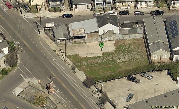
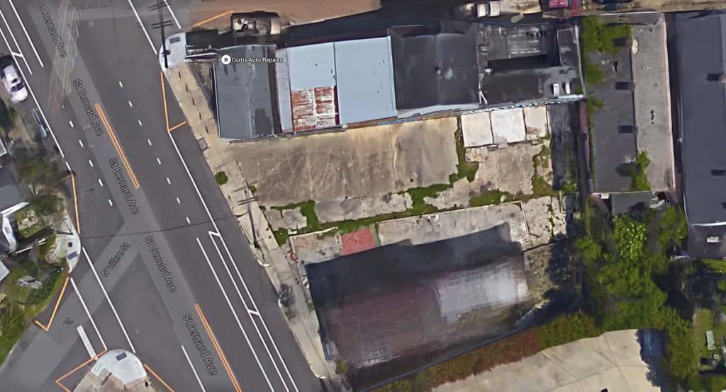
3 City Planning Commission Meeting CPC Deadline: 09/24/16 Tuesday, July 26, 2016 CC Deadline: 60 days from receipt City Council District: C Ramsey Zoning Docket: 073/16 PRELIMINARY STAFF REPORT To: City Planning Commission From: Robert Rivers, Executive Director Stephen Kroll, Assistant Planning Administrator Prepared by: Danica Adams Date: July 13, 2016 I. GENERAL INFORMATION Applicant: Request: Location: WAYNE LOUIS DARMAS This is a request for a Conditional Use to permit a parking lot (principal use) in an HMC-2 Historic Marigny/Tremé/Bywater Commercial District, RDO-2 Residential Diversity Overlay District, AC-1 Arts and Culture Diversity Overlay District and EC Enhancement Corridor Design Overlay District. Square , Lots 4 and 5, in the Third Municipal District, bounded by Saint Bernard Avenue and North Villere, Annette and Urquhart Streets. The municipal addresses are SAINT BERNARD AVENUE. (PD 4) Description: The subject site is comprised of two adjacent lots, Lot 4 and Lot 5, in the New Marigny/7 th Ward neighborhood, on Saint Bernard Avenue near the intersection with North Villerie Street, in an HMC-2 Historic Marigny/Treme/Bywater Commercial District. The total site area is approximately seven thousand, two hundred square foot (7,200 sf), all of which is proposed to be a seventeen (17) space parking lot. Lot 4 had a two story brick structure which was demolished sometime between 2007 and It now has a curb cut and is improved with only the remainder of a concrete foundation. Lot 5 is improved with a concrete pad. Why is City Planning Commission action required? Article 10, Section 10.2.A (Table 10-1) states that conditional use approval is required for parking lot (principal use) in the HMC-2 Historic Marigny/Tremé/Bywater Commercial District. The City Planning Commission is required to make a recommendation on all conditional use applications prior to City Council action, in accordance with Article 4, Section Action by the City Planning Commission of the Comprehensive Zoning Ordinance. ZD 073/16 3

4 II. ANALYSIS A. What is the zoning of the surrounding areas? What is the existing land use? And how are the surrounding areas used? The subject site is located within an HMC-2 Historic Marigny/Tremé/Bywater Commercial District which extends the length of St. Bernard Ave. from Claiborne Avenue to Saint Claude Avenue. The HMC-2 Historic Marigny/Tremé/Bywater Commercial District is intended to permit more intensive commercial uses while protecting the historic character of the district. The HMC-2 Historic Marigny/Tremé/Bywater Commercial District extends the length of St. Bernard Ave. from Claiborne to St. Claude Ave. St. Bernard Ave. is a two-lane, two-way street which cuts diagonally across the street grid from the lake towards the river. Between Claiborne Ave. and St. Claude Ave., there are existing sidewalks, onstreet parking, and a bike lane on both sides of St. Bernard Ave. There are no street trees on this section of St. Bernard. On the downriver side of St. Bernard Ave., the South 7 th Ward neighborhood is zoned as an HMR-2 Historic Marigny/Tremé/Bywater Residential District. On the upriver side of St. Bernard Ave., the South 7 th Ward neighborhood is zoned as an HMR-3 Historic Marigny/Tremé/Bywater Residential District. Both of these districts are developed with older single- and two-family residences located close to or on the front property line, with narrow, one-way streets, on-street parking, sidewalks, and occasional street trees. ZD 073/16 4
5 B. What is the zoning and land use history of the site? Zoning: Land Use: 1929 E Commercial 1953 D Multiple-Family District 1970 C-l General Commercial District 2015 (prior to 8/12/2015) B1-A Neighborhood Business District 2015 (effective 8/12/2015) HMC-2 Historic Marigny/Tremé/Bywater Commercial District 1929 Residential Single Family or Public/Semi-Public Property 1949 Residential Single Family or Park 1999 Single- and Two-Family Residential 1 C. Have there been any recent zoning changes or conditional uses or planned developments in the immediate area? If so, do these changes indicate any particular pattern or trend? There have been no relevant zoning actions within five blocks of the subject site in the past five years. D. What are the comments related to Stormwater Management? The applicant proposes to construct a new parking lot approximately seven thousand, two hundred square foot (7,200 sf) is size. Article 23, Section 23.3.A of the Comprehensive Zoning Ordinance states that developments with over 5,000 square feet of impervious surface, or on site greater than one acre in size, are required to submit a Stormwater Management Plan demonstrating compliance with the requirement to retain, detain, and/or filter 1.25 inches of stormwater on site. Although the size of the proposed parking lot is greater than five thousand square feet in area (5,000 sf), the applicant has proposed a permeable paving system, TruGrid, in place of a conventional impermeable surface such as asphalt or concrete. For this reason, a stormwater management plan (SWMP) is not required. The effectiveness of TruGrid as a permeable paving system is highly impacted by the thickness of the gravel sub-base, and is dependent on the removal of any existing impermeable material, such as asphalt or concrete. In order to confirm that the proposed paving system would be considered permeable, and therefore not require a SWMP, if approved, staff recommends the following proviso: Applicant shall submit a section detail of the proposed permeable paving system subject to the review of the City Planning Commission demonstrating that the design as proposed may be considered permeable. 1 The 1999 Land Use Plan presented a generalized indication of land uses, and was not lot-specific. ZD 073/16 5

6 E. What are the comments from the design review staff? Site Design The applicant has applied for a conditional use to permit a parking lot as a principal use in an HMC-2 Historic Marigny/Tremé/Bywater Commercial District and EC Enhancement Corridor Design Overlay District, on St. Bernard Ave near N. Villerie St. The municipal address is 1383 St. Bernard Ave. The site is comprised of two lots, together measuring approximately sixty seven feet (67 ) of street frontage on St. Bernard Ave. The total site area is approximately seven thousand, two hundred square foot (7,200 sf). The applicant is proposing to demolish the existing building and construct a new seventeen (17) space parking lot. The submitted plans indicate a new twenty one foot, four inch (24 4 ) curb cut to facilitate two-way access. The subject site is located within an EC Enhancement Corridor Design Overlay District. Article 18, Section EC Enhancement Corridor Design Overlay District states that the following additional approval standards shall be considered: 1. Development shall promote safe, convenient, and attractive pedestrian and bicycle access. 2. Compact neighborhood centers shall be created at major intersections to the ZD 073/16 6
7 extent possible in order to support transit. 3. Development shall ensure compatibility between commercial uses and surrounding residential areas. 4. The architectural design should be consistent with the context, character, scale and materials of structures in the adjacent areas. 5. Neon signage is prohibited on the interior or exterior of windows, other than an open sign. The parking lot as proposed does not meet standards 1, 3, or 4, in that the development does not promote pedestrian or bicycle access, it does not ensure compatibility between commercial and residential uses, and the design of the parking lot is inconsistent with the context, character, scale and materials of adjacent structures. In order to promote safe, convenient, and attractive pedestrian and bicycle access which is consistent with the character of the adjacent areas, the proposed development should include perimeter fencing. This fencing does not preclude the parking lot landscape requirements as stated in Article 23, Section To assure that the design meets the standards of the EC Enhancement Corridor Design Overlay District, if approved, staff recommends the following provisos: The applicant shall submit a revised parking lot site plan, subject to review and approval of the City Planning Commission staff, indicating seven foot (7 ) tall perimeter fencing. The portion of the fencing which faces St. Bernard Ave. should be secure as well as visually transparent, and be constructed of a combination of a two (2) to three (3) foot tall brick or brick veneer base, brick or brick veneer posts spaced every five (5) to eight (8) feet, and metal pickets between the posts. The remainder of the perimeter fencing between the proposed parking lot and the adjacent residential or commercial areas should be seven feet (7 ) tall, and constructed of opaque materials such as wood, brick, or brick veneer. Parking Lot Design Article 22 of the Comprehensive Zoning Ordinance requires that parking lot designs conform to certain specifications. As proposed, the parking lot does not meet all of the requirements for the design of off-street parking spaces. For example, the dimensions of the proposed parallel parking spaces is deficient by two feet, four inches (2 4 ) from the requirements of Article 22, Section 228.D. If approved, staff recommends the following proviso: The applicant shall submit a revised parking lot site plan subject to review and approval of the City Planning Commission staff, indicating compliance with all applicable standards of Article 22 of the Comprehensive Zoning Ordinance, including but not limited to: a) Dimensions of all parking stalls, sidewalks, driveways, wheel stops and curb cuts b) Lighting plan c) Location of litter receptacles ZD 073/16 7
8 Landscaping Article 23 of the Comprehensive Zoning Ordinance requires landscaping for the perimeter and interior of parking lots. The applicant has not provided a landscape plan. Article 23, Section 23.7.A Required Parking Lot Landscape states that an aboveground stormwater BMP is required in the interior or perimeter of all parking lots Article 23, Section 23.7.B Perimeter Parking Lot Landscape states that the portion of a parking lot that faces a public street must include a five foot (5 ) perimeter landscaped area Article 23, Section 23.7.C Interior Landscape states that one parking island must be provided for every ten parking spaces provided and that all rows of parking shall terminate in a landscaped area Article 23, Section 23.8 Buffer Landscape states that the portion of a parking lot which abuts a residential use must provide a ten foot (10 ) wide buffer landscaped area In addition to the above requirements, and as noted below, at the Planning Advisory Committee, the representatives of the Department of Parks and Parkways stated that the landscaping plan should be revised to include street trees. If the application is approved, it should be subject to the following proviso: The applicant shall submit a revised parking lot site plan, prepared by a licensed Louisiana landscape architect and subject to review and approval of the City Planning Commission staff, indicating compliance with all applicable standards of Article 23, including but not limited to the following: a) Compliance with all applicable landscape requirements for parking lots b) The genus, species, size, location, quantity, and irrigation of all proposed plant materials within both the site and the street right-of-way adjacent to the site, with applicable remarks and details; and c) Approval from the staff of the Department of Parks and Parkways of all street trees planted within the public right-of-way adjacent to the petitioned site. Signage No proposed signage has been submitted to date as part of this request. Pursuant to Article 24, signage is permitted in order to identify the name of the development and address. To ensure signage complies with the regulations outlined in the Comprehensive Zoning Ordinance, the staff recommends the following proviso: All proposed signage shall be in compliance with the standards as set forth in Article 24 of the Comprehensive Zoning Ordinance, subject to the review and approval of the City Planning Commission. ZD 073/16 8
9 Lighting No lighting plan has been submitted as part of this application. Lighting is subject to the on-site development standards found in Article 21, Section 21.5 Exterior Lighting, and should comply with the approval standards of the EC Enhancement Corridor Design Overlay District found in Article 18, Section If approved, staff recommends the following proviso: Applicant shall submit a lighting plan which includes parking lot lighting for the interior of the parking lot and pedestrian lighting for both the internal pedestrian area and the sidewalk, and which demonstrates compliance with Article 21, Section 21.5 Exterior Lighting. Environmental Standards The proposed conditional use meets all environmental performance standards listed in Article 21, Section These standards either do not apply to the nature of the proposed use (noise, vibration, dust and air pollution, regulated materials, proper drainage, fire and explosion hazards), or will be addressed by the recommended provisos listed in this report (litter control). Use Standards Parking lots (principal use) are subject to use standards found in Article 20, Section 20.3.OO.2. These are operational standards which regulate the manner in which the parking lot is used. If approved, staff recommends the following proviso: The parking lot shall operate in accordance with the standards listed in Article 20, Section 20.3.OO.2: a) The parking lot shall be used solely for the parking of passenger vehicles for periods of less than one (1) day and cannot be used as an off-street loading area. b) No sale, display, repair, or service of any kind is permitted in any parking lot. c) No buildings other than those for shelter of attendants or payment kiosks are permitted in a parking lot. The allowable shelters shall not exceed ten (10) feet in height and fifty (50) square feet in area. d) The parking lot shall be kept free from refuse and debris. All landscape shall be maintained in a healthy growing condition. Miscellaneous To ensure the Department of Safety and Permits does not issue building permits that are contradictory to the requirements of the conditional use; the staff recommends the following proviso: The Department of Safety and Permits shall issue no building permits or licenses for this project until final development plans are approved by the City Planning ZD 073/16 9
10 Commission and recorded with the Office of Conveyances. Failure to complete the conditional use process by properly recording plans within a one year time period or failure to request an administrative extension as provided for in Article 4, Section 4.3.H.2 of the Comprehensive Zoning Ordinance will void the conditional use approval. F. What impact will the proposed conditional use have on the transportation system, if any? What are the off-street parking and off-street loading requirements? Can they be provided on site? If not, is a waiver required? Traffic The subject site is currently vacant and is located in a commercial district abutting a residential area at the intersection of St. Bernard Ave. and North Villerie St. in the New Marigny/ 7 th Ward neighborhood. St. Bernard Ave. is a two-way street with a bike lane, on-street parking, and sidewalks on either side of the street. St. Bernard Ave. is considered a key arterial and is well connected to the remainder of the street grid. St. Bernard Ave. experiences light traffic, and the development of this site as a parking lot will not cause an increase in traffic. For these reasons, the staff does not see any traffic impact as a result of the development of a parking lot at this site. Parking According to Article 22, Section 22.4.A (Table 22-1), there is not a minimum or maximum number of parking spaces, handicapped spaces, or bicycle parking spaces that a parking lot (principal use) must provide. As proposed, the applicant has indicated seventeen (17) regular parking spaces, and zero (0) handicapped parking spaces or bicycle spaces. Loading No off-street loading spaces exist or are proposed for the site. Article 22, Section 22.7 regulates off-street loading spaces. Because there is no floor area associated with this proposal, there are no required loading spaces for parking lots (principal use). G. What effects/impacts would the proposed conditional use have on adjacent properties? The CPC staff believes that the new parking lot would generate a moderate increase in the levels of activity, noise, or litter in the surrounding areas and would therefore negatively impact the adjacent properties, particularly residential properties. The greater impact is to preserve an un-developed, auto-oriented void in an otherwise dense, walkable, urban environment. H. What are the comments from other agencies/departments/committees? ZD 073/16 10
11 Planning Advisory Committee The proposal was considered at the Planning Advisory Committee meeting on July 6, Concerns were raised by the Department of Public Works regarding the proposed driveway and sidewalk dimensions, as well as the Department of Parks and Parkways regarding a site plan that was errantly submitted, as well as the inclusion of street trees. The Committee passed a motion of no objection to the request subject to further review by the City Planning Commission, the Department of Parks and Parkways, and the Department of Public Works. I. Compliance with approval standards The City Planning Commission recommendation and the City Council decision on applications for a conditional use shall, on the basis of all information submitted, evaluate the impact of the conditional use on and the compatibility of the use with surrounding properties and neighborhoods to ensure the appropriateness of the use at a particular location. The Commission and Council are required to specifically consider the extent to which the proposed use meets the approval standards contained in Article 4, Section 4.3.F Approval Standards of the Comprehensive Zoning Ordinance. In this section, the staff evaluates the application using those standards. The proposed use at the specified location is not in conflict with the policies embodied in the adopted Master Plan. This standard is met. The proposal is not addressed by the Plan for the 21st Century, commonly known as the Master Plan. Chapter 14: Land Use Plan of the Master Plan designates the future land use of the petitioned site as Mixed-Use Historic Core. The goal, range of uses, and development character for that designation are copied below: MIXED-USE HISTORIC CORE Goal: Increase convenience and walkability for neighborhood residents and visitors within and along edges of historic core neighborhoods. Range of Uses: A mixture of residential, neighborhood business, and visitor-oriented businesses. Uses may be combined horizontally or vertically, and some structures may require ground floor retail with residence or offices on upper floors. In some areas where current or former industrial use is verified, existing buildings may be appropriate for craft and value added industry. Development Character: The density, height, and mass of new development will be consistent with the character and tout ensemble of the surrounding historic neighborhood. Appropriate transitions will be provided to surrounding residential areas. ZD 073/16 11
12 The overall intent of the mixed Use Historic Core designation is to encourage a variety of uses that are attractive to neighborhood residents and visitors, as well as a development character which is consistent with and complimentary to the historic nature of the neighborhood. The proposed use would allow the existing vacant lots to be used as a parking lot. There may be some instances where parking as a principal use would be allowable, or even, depending on the design, beneficial in a commercial corridor, however, this use is not specifically addressed by the master plan. In this case, the proposed parking lot does not directly interfere with the Master Plan. The proposed use is consistent with the general purpose and intent of the applicable zoning district regulations. This standard is not met. The HMC-2 Historic Marigny/Tremé/Bywater Commercial District is intended to permit more intensive commercial uses than the HMC-1 District, yet protect the historic character of the Marigny/Tremé/Bywater area. The proposed use as a parking lot does not protect the historic character of the Marigny/Treme/Bywater area. The proposed use meets all standards specifically applicable to the use as set forth in Article 20 and all environmental performance standards of Section The applicant has proposed that the site would be used as a parking lot. Article 20, Section 20.3.OO puts forth standards applicable to parking lot (principal use). These are operational standards, and if the proviso mentioned above, which requires compliance with these operation standards if approved, this standard will be met. Article 21, Section 21.3 sets forth Environmental Performance Standards which are not applicable to this use. The proposed use is compatible with and preserves the character and integrity of adjacent development and neighborhoods and, as required by the particular circumstances, includes improvements or modifications either on-site or within the public right-of-way to mitigate development-related adverse impacts. The applicant is proposing to use the subject site as a gravel parking lot. A gravel nonaccessory parking lot does not preserve the character or integrity of this mixed use commercial district. Due to the auto-oriented nature of the development, the lack of a principal use with a street façade, and the lack of adequate lighting, parking lots as a principal use do not promote the pedestrian character of the existing neighborhood or adjacent developments. As proposed, the site does not meet the standards for parking lots in either Article 22 or Article 23, and does not include improvements or modifications either on-site or in the right-of-way to mitigate any adverse impacts. While compliance with the above stated provisos may bring the proposed parking lot into compliance with this standard, as currently proposed, this standard is not met. Any variance of zoning standards meets the approval standards of Section 4.6.F. ZD 073/16 12
13 If the proposal is approved in conjunction with all of the provisos listed above, the requested conditional use will not necessitate any variance of zoning standards. The proposed use is not materially detrimental to the public health, safety, and welfare, or results in material damage or prejudice to other property in the vicinity. The proposed use will allow the development of a parking lot. The proposed use would not directly impair the public welfare, although it would degrade the urban environment. IV. SUMMARY This is a request for a Conditional Use to permit a parking lot as a principal use in an HMC- 2 Historic Marigny/Tremé/Bywater Commercial District, RDO-2 Residential Diversity Overlay District, AC-1 Arts and Culture Diversity Overlay District and EC Enhancement Corridor Design Overlay District. The applicant is proposing to construct a seven thousand, two hundred square foot (7,200 sf), seventeen (17) space parking lot over the entirety of Lots 4 and 5. The applicant is proposing to use a permeable paving system called TruGrid, which the applicant asserts would bring this development below the impervious threshold of 5,000 square foot that would require a Stormwater Management Plan. This use is a conditional use in the HMC-2 Historic Marigny/Tremé/Bywater Commercial District. The proposed parking lot on this site is not an appropriate use of the commercially zoned site and does not meet all of the relevant approval standards. It is not supported by the master plan, and is inconsistent with the intent of the HMC-2 District. V. PRELIMINARY STAFF RECOMMENDATION 2 The staff recommends DEFERRAL of Zoning Docket 073/16, a request for a Conditional Use to permit a parking lot as a principal use in an HMC-2 Historic Marigny/Tremé/Bywater Commercial District. VI. REASONS FOR RECOMMENDATION 1. For the proposed land use to be considered approvable, it would need to comply with applicable design guidelines and approval standards. As presented, the plans do not demonstrate compliance with above referenced standards. Staff recommends deferral to allow applicant additional time to provide plans which comply with necessary regulations. 2 Subject to modification by the City Planning Commission ZD 073/16 13

14 City of New Orleans Property Viewer July 12, 2016 Override 1 1:4, mi km
15

16 LOT.4-5 SQ THIRD DISTRICT ORLEANS PARISH, LA # N 1 PROPOSED PLOT PLAN
17
18
19
20

21
CITY PLANNING COMMISSION CITY OF NEW ORLEANS EXECUTIVE DIRECTOR. City Planning Commission Staff Report Executive Summary
 CITY PLANNING COMMISSION CITY OF NEW ORLEANS MITCHELL J. LANDRIEU MAYOR ROBERT D. RIVERS EXECUTIVE DIRECTOR LESLIE T. ALLEY DEPUTY DIRECTOR City Planning Commission Staff Report Executive Summary Zoning
CITY PLANNING COMMISSION CITY OF NEW ORLEANS EXECUTIVE DIRECTOR. City Planning Commission Staff Report. Executive Summary
 CITY PLANNING COMMISSION CITY OF NEW ORLEANS MITCHELL J. LANDRIEU MAYOR ROBERT D. RIVERS EXECUTIVE DIRECTOR LESLIE T. ALLEY DEPUTY DIRECTOR City Planning Commission Staff Report Zoning Docket 053/18 Executive
DEPARTMENT OF PLANNING JEFFERSON PARISH, LOUISIANA
 DEPARTMENT OF PLANNING JEFFERSON PARISH, LOUISIANA DESIGN REVIEW REPORT DOCKET NO: CPZ--16 SUMMAR NO.: : : Paul D. Johnston AT LARGE: A: Christopher L. Roberts B: Cynthia Lee-Sheng ADVERTISING DATES: PAB
DEPARTMENT OF PLANNING JEFFERSON PARISH, LOUISIANA
 DEPARTMENT OF PLANNING JEFFERSON PARISH, LOUISIANA DESIGN REVIEW REPORT DOCKET NO: : : : Paul D. Johnston AT LARGE: A: Christopher L. Roberts B: Cynthia Lee-Sheng ADVERTISING DATES: PAB PUBLIC HEARING:
DEPARTMENT OF PLANNING JEFFERSON PARISH, LOUISIANA
 DEPARTMENT OF PLANNING JEFFERSON PARISH, LOUISIANA DESIGN REVIEW REPORT : SUMMAR NO.: 4469 (S) Paul Johnston AT LARGE: A Chris Roberts B Cynthia Lee-Sheng ADVERTISING DATES: PAB PUBLIC HEARING: HEARING:
CITY OF NEW ORLEANS. City Planning Commission Staff Report. Executive Summary. Zoning Docket: 115/17. Stephanie Bissell Hoskins
 CITY PLANNING COMMISSION CITY OF NEW ORLEANS MITCHELL J. LANDRIEU MAYOR ROBERT D. RIVERS EXECUTIVE DIRECTOR LESLIE T. ALLEY DEPUTY DIRECTOR City Planning Commission Staff Report Zoning Docket: 115/17 Executive
DEPARTMENT OF PLANNING JEFFERSON PARISH, LOUISIANA
 DEPARTMENT OF PLANNING JEFFERSON PARISH, LOUISIANA DESIGN REVIEW REPORT : CPZ-3-1 : (S) Cynthia Lee-Sheng AT LARGE: A Chris Roberts B Elton M. Lagasse ADVERTISING DATES: 06/03/1 06/10/1 06/17/1 PAB PUBLIC
VILLAGE OF CLEMMONS PLANNING BOARD DRAFT STAFF REPORT
 VILLAGE OF CLEMMONS PLANNING BOARD DRAFT STAFF REPORT PETITION INFORMATION Docket # C-226 Staff Megan Ledbetter Petitioner(s) JBJH Properties, LLC Owner(s) JBJH Properties, LLC Subject Property 5892-49-1766
Urban Planning and Land Use
 Urban Planning and Land Use 701 North 7 th Street, Room 423 Phone: (913) 573-5750 Kansas City, Kansas 66101 Fax: (913) 573-5796 Email: planninginfo@wycokck.org www.wycokck.org/planning To: From: City Planning
C-I-10. The effect of establishing a comprehensive site review as follows will: B. Reduce the cluttered aspects of current development by:
 C-I-10 PART C SECTION I ARTICLE 10 GENERAL REGULATIONS PROJECT SITE REVIEW I. Purpose The effect of establishing a comprehensive site review as follows will: A. Protect streetscapes from projects that
McDonald s Restaurant - Purcellville Town of Purcellville Special Use Permit Statement of Justification July 24, 2014
 Introduction / Written Statement McDonald s Restaurant - Purcellville McDonald s Corporation is proposing to redevelop the existing McDonald s eating establishment with a drive-through located at 121 N
5.1.1 The streetscape along US Highway 64 (Brevard Road); and, The built environment within new residential developments; and,
; and, The built environment within new residential developments; and,") Article 5. Landscaping 5.1 Purpose The Town of Laurel Park s landscape standards are designed to create a beautiful, aesthetically pleasing built environment that will complement and enhance community
Article 5. Landscaping 5.1 Purpose The Town of Laurel Park s landscape standards are designed to create a beautiful, aesthetically pleasing built environment that will complement and enhance community
F. Driveways. Driveways which provide access to off-street parking or loading from public streets shall comply with the following:
 Section 20.945.040 General Design Standards for Surface Parking Areas. A. Review Authority. Parking lot design and drainage shall be subject to review and approval of the City Transportation Manager. B.
AWH REPORT OF THE PLANNING AND DEVELOPMENT DEPARTMENT FOR APPLICATION FOR REZONING ORDINANCE TO PLANNED UNIT DEVELOPMENT
 AWH REPORT OF THE PLANNING AND DEVELOPMENT DEPARTMENT FOR APPLICATION FOR REZONING ORDINANCE TO PLANNED UNIT DEVELOPMENT MAY 8, 2014 The Planning and Development Department hereby forwards to the Planning
Harmony Technology Park Third Filing, Second Replat Custom Blending, Project Development Plan/Final Development Plan - FDP #130021
 ITEM NO FDP #130021 MEETING DATE July 23, 2013 STAFF Pete Wray ADMINISTRATIVE TYPE I HEARING STAFF REPORT PROJECT: APPLICANT: OWNER: Harmony Technology Park Third Filing, Second Replat Custom Blending,
3.10 ROW Overlay District
 3.10 A. Purpose The purpose of this Overlay District is to regulate items which could be placed or constructed within the Rights-of-way lying wholly or partially within the jurisdictional area of the Town
Planned Development Review Revisions (Project No. PLNPCM )
") Planned Development Review Revisions (Project No. PLNPCM2014-00139) Standard residential development Planned Development Example: Smaller lot sizes than what is allowed to create open space amenity. What
Planned Development Review Revisions (Project No. PLNPCM2014-00139) Standard residential development Planned Development Example: Smaller lot sizes than what is allowed to create open space amenity. What
Article 7.05 Manufactured Home Park Districts
 Article Manufactured Home Park Districts.01 Intent The purpose of the MHP Manufactured Home Park District is to give recognition to the fact that manufactured homes can provide satisfactory living conditions
CITY PLANNING COMMISSION CITY OF NEW ORLEANS MITCHELL J. LANDRIEU ROBERT D. RIVERS EXECUTIVE DIRECTOR. City Planning Commission Staff Report
 CITY PLANNING COMMISSION CITY OF NEW ORLEANS MITCHELL J. LANDRIEU ROBERT D. RIVERS MAYOR EXECUTIVE DIRECTOR City Planning Commission Staff Report Executive Summary Summary of Uptown and Carrollton Local
UNIFIED DEVELOPMENT CODE
 Zoning UNIFIED DEVELOPMENT CODE Regulates how land is used Sets dimensional requirements for structures Addresses all aspects of site development: accessory structures, temporary uses, parking, landscape,
Chapter PEDESTRIAN COMMERCIAL (PC) ZONING DISTRICT
 ZONING DISTRICT") Chapter 11-17 PEDESTRIAN COMMERCIAL (PC) ZONING DISTRICT Sections: 11-17-01 GENERAL PURPOSE 11-17-02 PERMITTED BUILDING TYPES 11-17-03 USES PERMITTED WITH DESIGN REVIEW 11-17-04 USES PERMITTED BY CONDITIONAL
Chapter 11-17 PEDESTRIAN COMMERCIAL (PC) ZONING DISTRICT Sections: 11-17-01 GENERAL PURPOSE 11-17-02 PERMITTED BUILDING TYPES 11-17-03 USES PERMITTED WITH DESIGN REVIEW 11-17-04 USES PERMITTED BY CONDITIONAL
Staff Report. Conditional Use PLANNING DIVISION COMMUNITY & ECONOMIC DEVELOPMENT. Salt Lake City Planning Commission
 Staff Report PLANNING DIVISION COMMUNITY & ECONOMIC DEVELOPMENT To: From: Salt Lake City Planning Commission Maryann Pickering, Principal Planner (801) 535-7660 Date: December 10, 2014 Re: Church of Scientology
RESIDENTIAL DISTRICTS
 RESIDENTIAL DISTRICTS The residential district standards have been revised to reflect on-the-ground conditions, while continuing to respect the use patterns established within the neighborhoods. This will
ARTICLE 6: Special and Planned Development Districts
 ARTICLE 6: Special and Planned Development Districts 6-10 Traditional Neighborhood Development (TND) District 6-10.10 Purpose and Intent The Traditional Neighborhood Development (TND) District provides
Planning & Zoning Commission Staff Report
 Planning & Zoning Commission Staff Report Meeting Date: May 26, 2015 Drafted by: Katherine Harrison-Rogers CASE # Z2886 PROJECT NAME: APPLICANT/ REPRESENTATIVE: Shawna Runyan PROPERTY OWNER: 1840 (previously
CITY PLANNING COMMISSION CITY OF NEW ORLEANS MITCHELL J. LANDRIEU ROBERT D. RIVERS EXECUTIVE DIRECTOR. City Planning Commission Staff Report
 CITY PLANNING COMMISSION CITY OF NEW ORLEANS MITCHELL J. LANDRIEU ROBERT D. RIVERS MAYOR EXECUTIVE DIRECTOR City Planning Commission Staff Report Executive Summary Summary of Mid-City and Parkview Local
PLANNED UNIT DEVELOPMENT STAFF REPORT Date: June 2, 2016
 # 9 ZON2016-01032 PLANNED UNIT DEVELOPMENT STAFF REPORT Date: June 2, 2016 DEVELOPMENT NAME JJT Properties LLC LOCATION 1147 & 1151 East I-65 Service Road South and 1180 Sledge Drive (Southeast corner
CHAPTER 530 SITE PLAN REVIEW
 ARTICLE I. GENERAL PROVISIONS CHAPTER 530 SITE PLAN REVIEW Community Planning and Economic Development Development Services Division 250 South 4 th Street, Room 300 Minneapolis MN 55415-1316 612-673-3000
Landscaping Standards
 CHAPTER 29 ARTICLE 403 29.403 Landscaping Standards Purpose: The purpose of this section is to protect and promote the public health, safety and general welfare by requiring landscaping in relation to
PLANNING REPORT CITY OF EAGAN. APPLICANT: Cedar Grove Hospitality, LLC HEARING DATE: December 18, 2014
 PLANNING REPORT CITY OF EAGAN REPORT DATE: December 8, 2014 CASE: 19-PA-11-11-14 APPLICANT: Cedar Grove Hospitality, LLC HEARING DATE: PROPERTY OWNER: The Flats at Cedar APPLICATION DATE: Nov. 21, 2014
CHAPTER 3. Design Standards for Business, Commercial, Industrial, Recreational and Institutional Uses
 CHAPTER 3 Design Standards for Business, Commercial, Section Number Title Ordinance Number Date of Ordinance 16-3-1 Applicability 2006-11 2008-04 07-01-08 16-3-2 Uniform Standards for Architectural Design
CITY OF GARDEN CITY. Garden City Design Review Committee Staff Contact: Chris Samples STAFF REPORT: DSRFY Page 1
 Page 1 CITY OF GARDEN CITY 6015 Glenwood Street Garden City, Idaho 83714 Phone (208)472-2921 Fax (208)472-2926 File Number: DSRFY2018-12 For: Brilliant Services - New Commercial Structure Location: 211
ARTICLE 3 LANDSCAPING AND SCREENING REQUIREMENTS
 ARTICLE 3 CHAPTER 4 LANDSCAPING AND SCREENING REQUIREMENTS SEC 3.401 SEC 3.402 (D) (E) PURPOSE: The purpose of this Chapter is to establish minimum standards for the design, installation, and maintenance
PLNPCM Carl s Jr. Commercial Parking Lot at Redwood Road and 1700 South
 Staff Report PLANNING DIVISION COMMUNITY & NEIGHBORHOODS To: Salt Lake City Planning Commission From: Casey Stewart; 801-535-6260 Date: November 4, 2016 Re: PLNPCM2015-00874 Carl s Jr. Commercial Parking
MEMORANDUM. I2 District Downtown Parking Overlay District 24,000 square feet /.55 acres. Industrial Employment District North Loop Small Area Plan
 Department of Community Planning & Economic Development 50 South 4th Street, Room 300 Minneapolis, MN 5545-385 MEMORANDUM To: City Planning Commission, Committee of the Whole Prepared By: Peter Crandall,
COLVER ROAD INDUSTRIAL CONCEPT PLAN
 COLVER ROAD INDUSTRIAL CONCEPT PLAN A CONCEPTUAL LAND USE AND TRANSPORTATION PLAN FOR TA-4 AN URBAN RESERVE AREA OF THE CITY TALENT City of Talent Adopted by City Council Resolution No., June, 2015 PART
Urban Design Manual 2.0 DRIVE-THROUGH FACILITIES. Background. Urban Design Challenges
 222221 2.0 DRIVE-THROUGH FACILITIES Background In recent years, drive-through facilities have grown significantly in popularity with drive-through restaurants, in particular, being established on numerous
, C-MS I June 3, 2016 $1500 pd chk #216918
 , C-MS-8 LOTS 21 THROUGH 40, INCLUSIVE, BLOCK 299 CLEMENTS ADDITION TO THE CITY OF DENVER SOUTHEAST QUARTER OF SECTION 34, TOWNSHIP 3 SOUTH, RANGE 68 WEST, SIXTH PRINCIPAL MERIDIAN, CITY
Design Review Application *Please call prior to submittal meeting to determine applicable fees*
 CITY OF EAGLE 660 E. Civic Lane, Eagle, ID 83616 Phone#: (208) 939-0227 Fax: (208) 938-3854 Design Review Application *Please call prior to submittal meeting to determine applicable fees* FILE NO.: CROSS
R E S O L U T I O N. Single-Family Residence/ Church. 2,488 sq. ft. 2,488 sq. ft. Area Parking Required: Church
 R E S O L U T I O N WHEREAS, the Prince George s County Planning Board is charged with the approval of Detailed Site Plans pursuant to Part 3, Division 9 of the Zoning Ordinance of the Prince George s
MIXED-USE VILLAGE OVERLAY FLOATING DISTRICT
 MIXED-USE VILLAGE OVERLAY FLOATING DISTRICT Zoning regulations developed by committee to the Planning Board for the Town of DeWitt, NY Issue date: 13 July 2017 revised 3/12/2018, revised 4/26/2018, 5/9/2018
Rezoning Petition Pre-Hearing Staff Analysis September 17, 2018
 Rezoning Petition 2017-043 Pre-Hearing Staff Analysis September 17, 2018 REQUEST Current Zoning: R-3 (single family residential), R-17MF (multi-family residential), and CC (commercial center) Proposed
Staff Report and Recommendation
 Community Planning and Development Planning Services 201 W. Colfax Ave., Dept. 205 Denver, CO 80202 p: 720.865.2915 f: 720.865.3052 www.denvergov.org/cpd TO: City Council Neighborhoods and Planning Committee
WHEREAS, after consideration of the evidence presented at the public hearing on January 14, 2010, the Prince George's County Planning Board finds:
 R E S O L U T I O N WHEREAS, the Prince George s County Planning Board has reviewed DDS-600 requesting a departure for the location of two loading spaces without driveway access along Toledo Terrace in
CITY PLANNING COMMISSION AGENDA ITEM: C STAFF: ROBERT TEGLER FILE NO: CPC PUD QUASI-JUDICIAL
 CPC AGENDA June 8, 2006 Page 37 CITY PLANNING COMMISSION AGENDA ITEM: C STAFF: ROBERT TEGLER FILE NO: CPC PUD 05-294 - QUASI-JUDICIAL PROJECT: APPLICANT: OWNER: PARKWOOD AT WOLF RANCH NASS DESIGN ASSOCIATES
WEST LOOP DESIGN GUIDELINES CHECKLIST
 WEST LOOP DESIGN GUIDELINES CHECKLIST Section 1.0 General Strategies 1.1 DESIGN EXCELLENCE: ENCOURAGE HIGH QUALITY AND INNOVATIVE DESIGN OF NEW BUILDINGS WITHIN THE WEST LOOP WITHOUT BEING PRESCRIPTIVE
ORDINANCE WHEREAS, this Ordinance is consistent with the City of Winter Garden Comprehensive Plan; and
 ORDINANCE 17-06 AN ORDINANCE OF THE CITY COMMISSION OF THE CITY OF WINTER GARDEN, FLORIDA, CREATING ARTICLE XIV OF CHAPTER 118 OF THE CITY OF WINTER GARDEN CODE OF ORDINANCES PROVIDING FOR THE EAST PLANT
Zoning Technical Review Presented by Camiros. November 10, 2015
 Zoning Technical Review Presented by Camiros November 10, 2015 TECHNICAL REVIEW OVERVIEW Purpose of this Report Outline issues with current Ordinance Present preliminary approaches for revisions Set drafting
4.1.3 LAND USE CATEGORIES
 4.1.3 LAND USE CATEGORIES a. City Center District The City Center District incorporates the existing character and mix of uses in downtown Belmont to encourage redevelopment and new development in keeping
CITY PLANNING COMMISSION
 CITY PLANNING COMMISSION TO: HONORABLE CITY COUNCIL FROM: CITY PLANNING COMMISSION DATE: FEBRUARY 19, 2018 SUBJECT: REPORT AND RECOMMENDATION OF THE CITY PLANNING COMMISSION Ladies and Gentlemen: Attached
MIAMI 21 SEPTEMBER 2015 APPENDIX J: NEIGHBORHOOD REVITALIZATION DISTRICTS TABLE OF CONTENTS J.1. NEIGHBORHOOD REVITALIZATION DISTRICT NRD-1
 TABLE OF CONTENTS J.1. NEIGHBORHOOD REVITALIZATION DISTRICT NRD-1 1.1 Boundaries J.3 1.2 Intent J.3 1.3 Effect of District Designation J.3 1.4 Additional Notice and Review J.3 1.5 Wynwood Thoroughfares
VILLAGE OF CHANNAHON COMMERCIAL DESIGN GUIDELINES. Village of Channahon S. Navajo Drive Channahon, IL (815)
") VILLAGE OF CHANNAHON COMMERCIAL DESIGN GUIDELINES Village of Channahon 24555 S. Navajo Drive Channahon, IL 60410 (815) 467-6644 www.channahon.org Adopted March 6, 2006 VILLAGE OF CHANNAHON COMMERCIAL DESIGN
VILLAGE OF CHANNAHON COMMERCIAL DESIGN GUIDELINES Village of Channahon 24555 S. Navajo Drive Channahon, IL 60410 (815) 467-6644 www.channahon.org Adopted March 6, 2006 VILLAGE OF CHANNAHON COMMERCIAL DESIGN
CITY-COUNTY PLANNING BOARD DRAFT STAFF REPORT
 CITY-COUNTY PLANNING BOARD DRAFT STAFF REPORT PETITION INFORMATION Docket # W-3174 Staff Aaron King Petitioner(s) O Reilly Auto Parts Owner(s) Glenn Crossing Associates, LLC Subject Property Portion of
CHAPTER ADDITIONAL REQUIREMENTS IN THE NC, NEIGHBORHOOD COMMERCIAL ZONE
 CITY OF MOSES LAKE MUNICIPAL CODE CHAPTER 18.31 ADDITIONAL REQUIREMENTS IN THE NC, NEIGHBORHOOD COMMERCIAL ZONE Sections: 18.31.010 Purpose 18.31.020 Minimum Lot Area 18.31.030 Setbacks 18.31.040 Maximum
Request Alternative Compliance to the prescribed criteria of the Oceanfront Resort District Form-Based Code. Staff Planner Kristine Gay
 Applicant/Owner Ocean Rental Properties, LLC Public Hearing April 13, 2016 City Council Election District Beach Agenda Item 1 Request Alternative Compliance to the prescribed criteria of the Oceanfront
DEPARTMENT OF PLANNING JEFFERSON PARISH, LOUISIANA SITE PLAN REVIEW REPORT
 DEPARTMENT OF PLANNING JEFFERSON PARISH, LOUISIANA SITE PLAN REVIEW REPORT DOCKET NO.: MUC-3-15 ADVERTISING DATES: 7/22/15 7/29/15 SUMMARY NO: 24309 8/05/15 COUNCIL DISTRICTS: PUBLIC HEARING DATE: 8/13/15
DRAFT FOR COMMENT: EASTLAKE AVENUE PEDESTRIAN DISTRICT OVERLAY ORDINANCE
 DRAFT FOR COMMENT: EASTLAKE AVENUE PEDESTRIAN DISTRICT OVERLAY ORDINANCE Background: One of many actions in the 1998 Eastlake Neighborhood Plan was a proposal for an Eastlake Avenue Pedestrian District
ARTICLE RRCO RED ROCK CORRIDOR OVERLAY DISTRICT
 ARTICLE 11.10 RRCO RED ROCK CORRIDOR OVERLAY DISTRICT (adopted 11/22/2011 MC16-116-11) SECTIONS: 11.10.01 Intent 11.10.02 Boundaries of District 11.10.03 Development Standards 11.10.04 Variance 11.10.01
MONTGOMERY COUNTY PLANNING DEPARTMENT THE MARYLAND-NATIONAL CAPITAL PARK AND PLANNING COMMISSION
 MONTGOMERY COUNTY PLANNING DEPARTMENT THE MARYLAND-NATIONAL CAPITAL PARK AND PLANNING COMMISSION MCPB Item No. Date: 3.10.2016 Site Plan 820160040 Nora School Parker Smith, Planning Technician, Area 1,
Narcoossee Roadway Corridor
 Community Meeting Narcoossee Roadway Corridor April 5, 2012 Meeting Agenda Purpose of Meeting Continuation of Study Update Process (Previous Meetings Oct. & Nov., 2011) Tonight s Objective Review Proposals
CHAPTER SPECIAL PURPOSE AND OVERLAY ZONING DISTRICTS
 Special Purpose and Overlay Zoning Districts 106.28.010 CHAPTER 106.28 - SPECIAL PURPOSE AND OVERLAY ZONING DISTRICTS SPECIAL PURPOSE AND OVERLAY ZONING DISTRICTS Sections: 106.28.010 - Purpose 106.28.020
LANDSCAPE ORDINANCE PASADENA PLANNING DEPARTMENT (713) FAX (713)
 FAX (713)") LANDSCAPE ORDINANCE PASADENA PLANNING DEPARTMENT (713) 475-5543 FAX (713) 477-1072 ARTICLE X. LANDSCAPING OF NONRESIDENTIAL SITES* Sec. 9-195. Applicability. (a) This article shall apply to the following:
LANDSCAPE ORDINANCE PASADENA PLANNING DEPARTMENT (713) 475-5543 FAX (713) 477-1072 ARTICLE X. LANDSCAPING OF NONRESIDENTIAL SITES* Sec. 9-195. Applicability. (a) This article shall apply to the following:
TOP TEN LIST OF COMMUNITY CONCERNS REGARDING PROPOSED AMENDMENTS TO CHAPTER 42
 TOP TEN LIST OF COMMUNITY CONCERNS REGARDING PROPOSED AMENDMENTS TO CHAPTER 42 1. Extend the urban area to Beltway 8 in stages, over say a three-year period, prioritizing development in transit and declining
Chapter 19.5 LANDSCAPING REQUIREMENTS
 Chapter 19.5 LANDSCAPING REQUIREMENTS Sec. 19.5-1. Intent The intent of the landscaping requirements stated herein are as follows: To aid in stabilizing the environment's ecological balance by contribution
EXHIBIT A. Chapter 2.7 SPECIAL PLANNED DISTRICTS. Article XVIII 15th Street School Master Planned Development
 EXHIBIT A Chapter 2.7 SPECIAL PLANNED DISTRICTS Article XVIII 15th Street School Master Planned Development Sections: 2.7.3600 15 th Street School Master Planned Development 2.7.3610 Purpose 2.7.3620 Definitions
BE IT ORDAINED by the Board of Supervisors of Chesterfield County:
 Attachment A AN ORDINANCE TO AMEND THE CODE OF THE COUNTY OF CHESTERFIELD, 1997, AS AMENDED, BY AMENDING AND REENACTING SECTIONS 19.1-52, 19.1-53, 19.1-236, 19.1-247, 19.1-253, 19.1-263, 19.1-341, 19.1-346,
Application for Site Plan Review
 Application for Site Plan Review City of Pontiac Office of Land Use and Strategic Planning 47450 Woodward Ave, Pontiac, MI 48342 T: 248.758.2800 F: 248.758.2827 Property/Project Address: Sidwell Number:
BUILDING SCALE AND SETBACKS 5 ELEMENTS:... 5 FAÇADES (COMMERCIAL/RESIDENTIAL) 5
 5") VISION STATEMENT 3 UTILIZATION OF THE GUIDELINES 3 IMPLEMENTATION 3 PROCEDURES FOR DESIGN REVIEW 3 LAND USE AND ZONING 4 LAND USE 4 ELEMENTS:... 4 ZONING 4 ELEMENTS:... 4 BUILDING SCALE AND SETBACKS 5
VISION STATEMENT 3 UTILIZATION OF THE GUIDELINES 3 IMPLEMENTATION 3 PROCEDURES FOR DESIGN REVIEW 3 LAND USE AND ZONING 4 LAND USE 4 ELEMENTS:... 4 ZONING 4 ELEMENTS:... 4 BUILDING SCALE AND SETBACKS 5
Gas Stations ottawa.ca
 Urban Design Guidelines for Gas Stations ottawa.ca Ce document est disponible en français sur ottawa.ca. This document is available in French on ottawa.ca. Approved by City Council May 24, 2006 City of
BOULEVARD AND PARKWAY STANDARDS
 88-323 BOULEVARD AND PARKWAY STANDARDS 88-323-01 PURPOSE Considerable public and private investment exists and is expected to occur adjacent to boulevards and parkways within the city. The following standards
BUFFERS, TREE PROTECTION AND LANDSCAPING. Sec Purpose and Intent.
 ARTICLE 20 BUFFERS, TREE PROTECTION AND LANDSCAPING Sec. 20.1. Purpose and Intent. Trees improve air and water quality, reduce soil erosion, reduce noise and glare, provide habitat for desirable wildlife,
Toronto Complete Streets Guidelines
 Toronto Complete Streets Guidelines 108 110 7.1 Green Infrastructure Design Principles 112 7.2 Context-Sensitive Green Streets 114 7.3 Key Green Street Elements Green infrastructure refers to natural and
Kingfisher Planned Development (PLNSUB ) and Special Exception (PLNPCM ) Planned Development and Special Exception
 and Special Exception (PLNPCM ) Planned Development and Special Exception") Staff Report PLANNING DIVISION COMMUNITY & ECONOMIC DEVELOPMENT To: From: Salt Lake City Planning Commission Maryann Pickering, Principal Planner (801) 535-7660 Date: October 22, 2014 Re: Kingfisher Planned
Staff Report PLANNING DIVISION COMMUNITY & ECONOMIC DEVELOPMENT To: From: Salt Lake City Planning Commission Maryann Pickering, Principal Planner (801) 535-7660 Date: October 22, 2014 Re: Kingfisher Planned
17.11 Establishment of Land Use Districts
 17.11 Establishment of Land Use Districts 17.11.010 Purpose. To promote the health, safety, and general welfare of City residents and those who come to South Salt Lake to work, exchange commerce and recreate.
PLANNING COMMISSION. Agenda Item # 3.
 PLANNING COMMISSION Agenda Item # 3. CASE SUMMARY Conditional District Rezoning Planning Commission February 4, 2015 CD-9-215 Jeff Walton, 341-3260, jeff.walton@wilmingtonnc.gov Staff recommendation CONDITIONAL
ARTICLE 13 STREETS General
 ARTICLE 13 STREETS 13.1 General Streets shall be designed to suit their functions. Many streets have purposes other than vehicular traffic. As an alternative to current N.C. Department of Transportation
Metropolitan Area Planning Council 60 Temple Place, Boston, Massachusetts fax
 Metropolitan Area Planning Council 60 Temple Place, Boston, Massachusetts 02111 617-451-2770 fax 614-482-7185 www.mapc.org Serving the 101 Cities Towns in the Metropolitan Boston Region MEMORANDUM TO:
ARTICLE 9: LANDSCAPING AND FENCING REQUIREMENTS
 ARTICLE 9: LANDSCAPING AND FENCING REQUIREMENTS Section 9.01 Intent The intent of the landscaping requirements are to improve the appearance of lot areas and soften paved areas and buildings; to provide
PLANNING COMMISSION. Agenda Item # 3
 PLANNING COMMISSION Agenda Item # 3 CASE SUMMARY Special Use Permit MEETING: Planning Commission, October 6, 2010 CASE NO: SITE ADDRESS: PROPOSAL: PRESENTED BY: STAFF RECOMMENDATION: SU-4-1010 406 S. 21st
CITY OF MANHATTAN BEACH DEPARTMENT OF COMMUNITY DEVELOPMENT. TO: Parking and Public Improvements Commission
 Clay Curtin, Management Analyst (I the same walls at a maximum of 1 foot tall. Section 7.36.150 of the Municipal Code permits BY: Eric Haaland, Associate Planner right-of-way) between walkways leading
5.1 Commercial and Industrial Development. (Effective April 1, 2006)
") 5.1 Commercial and Industrial Development. (Effective April 1, 2006) A. Applicability: The requirements of this section (5.10) shall apply to all uses within the LB Local Business; HB Highway Business;
5.1 Commercial and Industrial Development. (Effective April 1, 2006) A. Applicability: The requirements of this section (5.10) shall apply to all uses within the LB Local Business; HB Highway Business;
AMEND DMENT H HOSPITAL
 AMEND DMENT TO LAND USE PLAN ELEMENT VILLAGE OF RIDGEWOOD MASTER PLAN H HOSPITAL ZONE DISTRICT Village of Ridgewood Planning Board February 28, 2014with technical revisions from June 9, 2014 Planning Board
Metropolitan Area Planning Council 60 Temple Place, Boston, Massachusetts fax
 Metropolitan Area Planning Council 60 Temple Place, Boston, Massachusetts 02111 617-451-2770 fax 614-482-7185 www.mapc.org Serving the 101 Cities and Towns in the Metropolitan Boston Region MEMORANDUM
CITY PLANNING COMMISSION AGENDA. ITEM NO(s): C.1 C.3 STAFF: STEVE TUCK
: C.1 C.3 STAFF: STEVE TUCK") Page 34 CITY PLANNING COMMISSION AGENDA ITEM NO(s): C.1 C.3 STAFF: STEVE TUCK FILE NOS: CPC ZC 12-00035 QUASI-JUDICIAL CPC NV 12-00036 QUASI-JUDICIAL AR DP 12-00039 QUASI-JUDICIAL PROJECT: APPLICANT: OWNER:
Page 34 CITY PLANNING COMMISSION AGENDA ITEM NO(s): C.1 C.3 STAFF: STEVE TUCK FILE NOS: CPC ZC 12-00035 QUASI-JUDICIAL CPC NV 12-00036 QUASI-JUDICIAL AR DP 12-00039 QUASI-JUDICIAL PROJECT: APPLICANT: OWNER:
ARTICLE 13 STREETS General
 ARTICLE 13 STREETS 13.1 General Streets shall be designed to suit their functions. Many streets have purposes other than vehicular traffic. As an alternative to current N.C. Department of Transportation
REZONING APPLICATION MPD SUPPLEMENT
 REZONING APPLICATION MPD SUPPLEMENT For Staff Use Only: DATE/TIMESTAMP: ZA# RECEIVED BY: The intent of the Master Planned District (MPD) designation is to allow flexibility in the design and construction
PLANNING COMMISSION STAFF REPORT S. Apartments Planned Development PLNSUB Planned Development 247 West 1400 South March 12, 2014
 PLANNING COMMISSION STAFF REPORT 1400 S. Apartments Planned Development PLNSUB2013-00997 Planned Development 247 West 1400 South March 12, 2014 Applicant: Wasatch Advantage Group, represented by Adam Lankford
The GATEWAYS Sub Area Master Plan. City of Walker
 The GATEWAYS Sub Area Master Plan City of Walker Introduction: The Walker City Commission and Planning Commission decided in 2011 to create a sub-area master plan for the Remembrance Road and Wilson Avenue
PROPOSED BLOCK LENGTH CODE AMENDMENT
 10.426 Street Circulation Design and Connectivity. These standards are intended to assure that development will ultimately result in complete blocks bound by a network of public streets, and/or private
Downtown / Ballough Road Redevelopment Board
 Agenda Item 5 CONDITIONAL USE DEV2014-095 Pai in the Sky Downtown / Ballough Road Redevelopment Board Staff Report TO: Downtown / Ballough Road Board Members FROM: Jason Jeffries, Project Manager DATE:
ORDINANCE NO
 ORDINANCE NO. 2014-032 Amending Ordinance 2012-059 granting encroachment to the University of South Carolina for use of the right of way area of the 1500 block of Greene Street and 800 block of Pickens
 PLANNING COMMISSION STAFF REPORT MEETING DATE: PROJECT NUMBER: ZONE: REQUEST: ADDRESS: APPLICANT: PREPARED BY: 6 July 2017 D-17-006 Commercial Corridorr Design Review Approval a parking lot expansion 26
DRAFT DESIGN GUIDELINES
 IHZ Booklet #7 May 6, 2010 DRAFT DESIGN GUIDELINES CANTERBURY 7 Overview During the recent planning process for the Plan of Conservation and Development community character was identified as an important
SUBDIVISION, PLANNED UNIT DEVELOPMENT, PLANNING APPROVAL, REZONING & SIDEWALK WAIVER STAFF REPORT Date: February 7, 2013
 SUBDIVISION, PLANNED UNIT DEVELOPMENT, PLANNING APPROVAL, REZONING & SIDEWALK WAIVER STAFF REPORT Date: February 7, 2013 APPLICANT NAME SUBDIVISION NAME DEVELOPMENT NAME LOCATION S. E. Cemeteries of AL
Chapter RM MULTI FAMILY BUILDING ZONES
 Chapter 19.17 RM MULTI FAMILY BUILDING ZONES 19.17.010 Established 19.17.020 Primary Permitted Uses 19.17.030 Accessory Permitted Uses 19.17.040 Secondary Permitted Uses 19.17.050 Conditional Property
VILLAGE OF CLEMMONS PLANNING BOARD DRAFT STAFF REPORT. Single Family Residential, Townhomes
 VILLAGE OF CLEMMONS PLANNING BOARD DRAFT STAFF REPORT PETITION INFORMATION Docket # C-212 Staff Megan Ledbetter Petitioner(s) Peacehaven Development LLC Owner(s) Larry Jarvis, William Alexander and Peacehaven
To encourage commercial development which is consistent with the long range, comprehensive, general plan for Knoxville and Knox County.
 Page 1 of 5 9. - C-6 general commercial park district. A. Legislative purpose, intent and application. The legislative purpose, intent and application of the general commercial park development [district]
4.500 Preston Road Overlay District
 Section 4.500 Preston Road Overlay District 2004 Zoning Ordinance 4.500 Preston Road Overlay District (ZC 98-29; Ordinance No. 98-9-12) 4.501 Purpose To provide appropriate design standards for the use
SDOT DPD. SDOT Director s Rule DPD Director s Rule DCLU DR SED DR of 7 CITY OF SEATTLE
 SDOT SDOT Director s Rule 2-07 DPD Applicant: CITY OF SEATTLE Page 1 of 7 Supersedes: DCLU DR 11-93 SED DR 93-4 Seattle Department of Transportation (SDOT) Department of Planning and Development (DPD)
ORDINANCE AN ORDINANCE TO ADD A NEW SECTION 4.N. IN THE ZONING CODE FOR THE TOWN OF MIDDLETOWN, RELATING TO MIXED-USE DEVELOPMENT
 Introduced: November 5, 2018 Approved: ORDINANCE 18-11-01 AN ORDINANCE TO ADD A NEW SECTION 4.N. IN THE ZONING CODE FOR THE TOWN OF MIDDLETOWN, RELATING TO MIXED-USE DEVELOPMENT BE IT ENACTED BY THE MAYOR