Target: 27th October 2016 (Extension of Time Agreed Until )
|
|
|
- Eileen Bond
- 5 years ago
- Views:
Transcription
1 APP 01 Application Number: 16/02106/OUT Outline application (all matters reserved except access) for residential development of up to 150 dwellings, estate road, open space and associated works. AT Land Off, Castlethorpe Road, Hanslope FOR LA Trading LTD Target: 27th October 2016 (Extension of Time Agreed Until ) Ward: Newport Pagnell North And Hanslope Parish: Hanslope Parish Council Report Author/Case Officer: Katy Lycett Contact Details: Team Leader: Sarah Evans Team Leader Strategic Business Unit Contact Details: INTRODUCTION (A brief explanation of what the application is about) The main body of the report set out below draws together the core issues in relation to the application including policy and other key material considerations. This is supplemented by an appendix which brings together planning history, additional matters and summaries of consultees responses and public representations. Full details of the application, including plans, supplementary documents, consultee responses and public representations are available on the Council s Public access system All matters have been taken into account in writing this report and recommendation. 1.1 The Site The application site is a currently arable field with an area of approximately 10.2 hectares adjacent to Castlethorpe Road in Hanslope. The site is bounded to the north in part by Williams Close. Along the eastern boundary of the site are rear gardens of Western Drive and with Castlethorpe Road to the south. The site falls outside the established settlement boundary of Hanslope village. Details of the location of the site and its relationship to surrounding properties can be seen in the plans attached to this report. This application is being brought to DCC due to the number of objections which have been received.
2 1.2 The Proposal This application seeks consent for outline planning consent for up to 150 dwellings with all matters reserved except access. The application for the residential dwellings would include estate roads, open space and associated works. An indicative layout plan has been provided however this is subject to change and would not form part of any list of approved documents. The proposed vehicle access is proposed to be taken from Castlethorpe Road approximately 15 metres from the existing agricultural access. A new pedestrian access link would be provided from the public open space area to meet the existing footway adjacent to the northern boundary of the site. The application includes the provision of 33% affordable housing managed by a registered provider of special housing and will remain in perpetuity. The application also includes details of the provision for additional contributions which will be set out in detail further in this report. Details of the proposal as described above can be seen in the plans appended to this report 2.0 RELEVANT POLICIES (The most important policy considerations relating to this application) 2.1 National Policy National Planning Policy Framework Paragraphs 11-16: Presumption in favour of sustainable development Paragraph 17: Core Planning Principles Section 1: Building a Strong Competitive Economy Section 3: Supporting a Prosperous Rural Economy Section 4: Promoting Sustainable Transport Section 6: Housing Section 7: Design Section 8: Promoting Healthy Communities Section 10: Meeting the challenge of climate change & Flooding Section 11: Conserving and Enhancing the Natural Environment Paragraph 173: Ensuring Viability and Deliverability Paragraphs 187 &187: Positive approach to decision taking Paragraphs 196 & 197: Determining Applications Paragraphs : Conditions and Obligations 2.2 Local Policy Core Strategy Policy CSA: Presumption in favour of sustainable development Policy CS1: Milton Keynes Development Strategy Policy CS9: Strategy for the Rural Area Policy CS10: Housing Policy CS11: A Well Connected Milton Keynes Policy CS12: Developing Successful Neighbourhoods
3 Policy CS13: Ensuring High Quality, Well Designed Places Policy CS14: Sustainable Construction Policy CS18: Healthier and Safer Communities Policy CS19: The Historic and Natural Environment Policy CS21: Delivering Infrastructure Adopted Milton Keynes Local Plan Policy S1: General Principles Policy S7: Key Settlements Policy S10: Open Countryside Policy D1: Impact of Development Proposals on Locality Policy D2A: Urban Design Policy D2: Design of Buildings Policy D4: Sustainable Construction Policy HE1: Protection of Archaeological Sites Policy T1: Transport User Hierarchy Policy T2: Access for those with Impaired Mobility Policy T3: Pedestrians and Cyclists Policy T5: Public Transport Policy T9: The Road Hierarchy Policy T10: Traffic Policy T15: Parking Provision Policy NE1: Nature Conservation Sites Policy NE2: Protected Species Policy NE3: Biodiversity and Geological Enhancement Policy NE4: Conserving and Enhancing Landscape Character Policy H2-H5: Affordable Housing Policy H7: Housing on Unidentified Sites Policy H8: Housing Density Policy H9: Housing Mix Policy E1: Protection of Existing Employment Land Policy L3: Standards of Open Space Provision & Appendix L3 Policy C4: Education Policy PO4: Planning Obligations Supplementary Planning Guidance Parking Standards for Milton Keynes SPD (2016) Sustainable Construction SPD (2007) Social Infrastructure Obligations SPD (2005) Education SPG (2004) Leisure, Recreation & Sports SPG (2005) Affordable Housing SPD (2013) Residential Design Guide (2012) Additional Documents Hanslope Parish Plan 2009 (this document has not been formally adopted and does not constitute a Neighbourhood Plan).
4 3.0 MAIN ISSUES (The issues which have the greatest bearing on the decision) The principle of residential development of this site given National and Local Planning Policy and the requirement to provide a five year housing land supply. 2. Access and Highway Matters 3. Ecology and Biodiversity. 4. Loss of Agricultural Land 5. Impact on Footpath 6. Section 106 Contributions. 7. Impact on Neighbouring Dwellings. 8. Landscape and Design 9. Density 10. Drainage 4.0 RECOMMENDATION (The decision that officers recommend to the Committee) 4.1 It is recommended that planning permission be granted subject to the conditions set out at the end of this report and the successful completion of a s106 agreement. 5.0 CONSIDERATIONS (An explanation of the main issues that have lead to the officer Recommendation) 5.1 Principle of Development The site lays outside the development limits of Hanslope as shown in the Adopted Local Plan and therefore falls within the designated Open Countryside. Saved Policy S10 of the local plan states that planning permission will only be granted for development in the open countryside where it is essential for agriculture, forestry, countryside recreation and other development which is wholly appropriate to a rural area and cannot be located within a settlement. 5.2 However, paragraph 49 of the NPPF states that policies which constrain the supply of housing should be considered to be out of date where the Council cannot demonstrate a five-year supply of deliverable housing sites. Currently the Council cannot demonstrate a 5 year housing land supply. On that basis the current proposal must be considered with regard to Paragraph 14 of the NPPF which provides a presumption in favour of sustainable development and provides that permission should be granted unless adverse impacts significantly and demonstrably outweigh the benefits of proposals. The first question therefore must be does the proposal constitute sustainable development. The NPPF identifies three elements to the test of sustainability: social, economic and environmental. These elements are mutually dependant and should not be taken in isolation.
5 5.3 It has been accepted by the Council that it is currently unable to demonstrate a five-year supply of deliverable sites and for this reason the Council must rely upon the provisions of Paragraph 14 of the National Planning Policy Framework when considering the submitted application. Paragraph 14 states that: At the heart of the National Planning Policy Framework is a presumption in favour of sustainable development. For decision taking this means; approving development proposals that accord with the development plan without delay; and where the development plan is absent, silent or relevant policies are out of date, granting permission unless: - any adverse impacts of doing so would significantly and demonstrably outweigh the benefits, when assessed against the policies in this Framework taken as a whole; or specific policies in this Framework indicate development should be restricted 5.4 Social Element of Sustainable Development As part of the promotion of sustainable development, the NPPF requires that housing is located where it will enhance or maintain the viability of rural communities and be within a sustainable location. The application site would be immediately adjacent to the development limits of Castlethorpe for part of the site boundary with the proposed access being introduced along Castlethorpe Road. The local bus service routes (33/33A) are considered to be within walking distance from the site in order to provide sustainable transport options. 5.5 The submitted Affordable Housing Statement sets out that the total number of affordable units would be 50 which results in a provision of 33.3% (an additional 3% (5 units) over the required provision. Thirty eight of the dwellings would be for rent and twelve for shared ownership. This is considered as full compliance with the Local Plan Affordable Housing Policy and makes a positive contribution to the provision of a varied housing mix. The Council needs Affordable housing for Rent for households in housing need it had 506 households placed in temporary accommodation of which 178 were in B&B at 28 August Economic Element of Sustainable Development The construction activities associated with the development could generate employment opportunities for the local community during construction, and have associated benefits for local services and suppliers in the short term. In the longer term, the development would support the local economy in terms of the increased use of local shops, services and facilities. It is therefore considered that the proposed development would be sustainable in terms of economic considerations. 5.7 Nevertheless the provision of an additional 150 dwellings would put additional pressures on services and facilities in the area. These issues are
6 considered in detail in terms of the proposed Section 106 agreement discussed below. Subject to these matters being agreed it is considered that the proposed development would be sustainable in terms of economic considerations. 5.8 Environmental Elements of Sustainable Construction The application site is currently arable land with a limited number of trees and other features on site. There are no indications that the proposal would have a significant impact upon the environmental value of the site that could not be offset by a variety of mitigation measures which could be required by condition. It is therefore considered that the proposal can be considered sustainable in terms of the environmental impact. 5.9 The proposal is considered to constitute sustainable development and, in view of the Council s position in terms of a 5 year housing land supply, it is considered that the principle of the development is acceptable despite the fact that it is in the open countryside. In addition to this current situation there is also further wider benefits as a result of additional contributions including affordable housing provision which are being put forward as part of the application. These would create local positive additions to Hanslope village and the wider area in terms of highway improvements for example Access and Highway Matters The proposed development is submitted as Outline only with all matters reserved bar access. As a result this issue has been considered in detail with regards to traffic, junction arrangements and road safety. The Senior Highway Engineer is continuing discussions with the applicant to seek further clarification on traffic calming measures however has concluded at this stage that there is no objection to the proposed development subject to conditions and additional works secured through the s106 agreement One of the most significant proposals as part of this submission is the intended changes to the Castlethorpe Road/Long Street Road/Gold Street junction by substituting the existing mini-roundabout with a T-junction. It has been discussed that installing a priority T junction should be included in the package of works for off-site improvements and secured through the s106 agreement. This will allow further discussions to take place to agree details of the layout to ensure that any works are suitable and appropriate for longterm traffic movements in the local area. It is acknowledged that a development of up to 150 dwellings doesn t have an impact upon the local road network but the applicant has offered to mitigate for the impact of background traffic growth up to the future year assessment period of 5 years. There is no in-principle objection to the application from a highways perspective with regards to the access onto Castlethorpe Road With regards to the site s accessibility in the Transport Assessment states that the site is fully accessible by both cycle and on foot with easy access to village retail services. It is also agreed that the school is also within easy walk/cycle distance. A footway exists on the site side of Castlethorpe Road.
7 There is no segregated cycling facility but that is not unusual in the rural areas of Milton Keynes As part of any reserved matters application more detailed plans and information will be provided relating to highway layout, parking arrangements and provision and these will be assessed in detail in accordance with relevant policies and criteria Ecology and Biodiversity The application site is not subject to any statutory or non-statutory ecological designations. Due to the current use of the land there is negligible value in terms of ecology and wildlife habitats. The majority of trees and hedgerows surrounding the site are to be retained under the submitted application and any hedgerow losses will be compensated with hedgerow planting. It has been requested by the Countryside Officer that further surveys and information would be required as part of any reserved matters application including bat surveys, lighting scheme and a biodiversity enhancement proposal. The supporting documentation states that mitigation for any loss and an overall gain will be provided by the creation of native tree and hedgerow planting, wildflower grassland creation, new balancing pond, new roosting opportunities and nesting habitats. In this case the current proposal is in Outline form only and the impact of the development upon the protected species can only be considered when the details of the development are submitted at the Reserved Matter stage. It is therefore considered that these issues can be adequately covered by condition at this stage. It is noted however that the ratio of built form to public open space is considered to be an appropriate level allowing sufficient areas for landscaping and biodiversity. Paragraphs 109 and 117 of the NPPF call for all new development proposals to ensure that they do not lead to a net loss in biodiversity and that wherever possible to contribute to provide a net gain. There is scope within this proposal to retain some of the existing features and to provide enhancements. The proposal is consistent with NPPF guidance Loss of Agricultural Land The site is currently classed as both Class 3A and 3B in-part as per Natural England s classification. The NPPF encourages the effective use of land by reusing land that has been previously developed (brownfield land), provided that it is not of high environmental value (paragraph 17). This is not a brownfield site; it is greenfield. With the lack of available previously developed land in the District there is a need for new development to be on agricultural land. It is not wholly the best and most versatile land referenced in paragraph 112 of the NPPF and which in turn seeks to direct development to poorer quality land. The present land use and its classification as poor quality should not preclude planning permission from being granted Impact on Footpath The statement below has been provided as part of the application
8 submission which involves some of the existing footpaths being retained in situ and others being altered in order to accommodate the proposed development: It is considered that the two Public Right of Way diversions which pass through the proposed residential development will be contained within a high quality street scene comprising avenue tree planting. Diverting Public Rights of Way through the proposed development allows for an enhanced level of connectivity between the proposed residents and the wider village setting and countryside setting to the south east and north west respectively. This supporting information is considered to be acceptable in order to ensure that the site will remain open and accessible and any works to existing footpaths will be appropriately detailed to secure their use in the long term Section 106 Contributions The table below sets out the likely s106 contributions calculated in accordance with MKC Supplementary Planning Documents and Guidance. Community Infrastructure Levy (CIL) Regulations: Any requests must be CIL regulation 122 compliant, which means it must be have regard to the following statutory tests: A planning obligation may only constitute a reason for granting planning permission for the development if the obligation is (a) necessary to make the development acceptable in planning terms; (b) directly related to the development; and (c) fairly and reasonably related in scale and kind to the development From the 6th April 2015, when assessing whether any s106 contribution the local authority is required under the Community Infrastructure Levy Regulations (CIL Regulation 123) to ensure that we have not entered into 5 other s106 obligations for the same project or type of infrastructure since April Therefore, any contribution sought must not exceed the pooling restriction. I can confirm that for this development, Pooling is not a concern and therefore this will not hamper the ability to secure any of the contributions listed below. Education: Contribution Total Early Years 106, Primary pupils 525, Secondary pupils 565, Post 16 pupils 122,583.60
9 Leisure Recreation & Sports: Provision Cost Maintenance Cost Playing Fields 78, , Local Play Onsite Provision Neighbourhood Play 112, , Community Hall 34, n/a Local Parks Onsite Provision District Parks Onsite Provision Swimming Pool 47, n/a Allotments 14, n/a Sports Hall 17, n/a Social Infrastructure: Contribution Library 34, Adult Continuing Education 16, Crematorium/Burial Grounds 13, Museums and Archives (local heritage) 24, Health Facilities 235, Waste Management 38, Waste Receptacles 15, Social Care - Day Care 8, Social Care - Older Persons Housing 50, Emergency Services 7, Voluntary Sector 28, Inward Investment & Skills (University & College) 175, Public Art - 1% (Estimated) 75, Other Requirements: Contribution Carbon Neutrality (Estimated) 75, To be Bus Voucher provided Village Amenities Contribution 75, Total Contribution: 2,708, Per Unit: 18,055.45
10 5.19 This equates to a total contribution of 2,708, / 18, per dwelling plus the provision of an onsite Locally Equipped Area of Play (LEAP) and Public Open Space within the application site. In addition to the above contributions, the applicant will offer for the Public Open Space and LEAP to the Council for adoption along with a commuted sum for the ongoing maintenance (amount to be calculated based on provision)and will enter into a s278 agreement to undertake the highway works referred to above in paragraph As part of the application submitted a Heads of Terms document was provided and stated the following contributions would be offered for consideration and discussion: - 33% of the dwellings within the affordable category for people who cannot afford to meet their housing needs on the open market Contributions towards educational and other community facilities necessitated by the development to serve the future population A Local Area for Play and open space on the site An area of land in the North East corner of the site reserved for school expansion/rebuild or expansion of the school playing fields and a parking and turning area for the school. The Education Sufficiency and Access team have confirmed this land can be accepted for school use An area of land, reserved for a doctors surgery/community use and a parking area for the doctors surgery/recreation ground. The applicant has agreed to lay out a car park during the construction of the development for us by the patients using the doctors surgery and users of the Pavilion and playing fields opposite the development Discussions have been held between the applicant, the Chair of the Parish Council and Officers in order to support community involvement and determine the priority contributions being sought. The applicant has agreed to the Heads of Terms set out above, including the additional items previously offered including the additional Public Open Space, the land for the school and land for possible doctors surgery expansion and the laying out of a car park which should be secured through a Section 106 Agreement. It should be noted that the applicant is providing on-site open space which exceeds the Council s requirements in accordance with Milton Keynes Local Plan Policy L3. The Section 106 requirements and additional items offered by the applicant are considered to make the development acceptable in planning terms and meet the tests set down by CIL Regulation 122 as they directly related to the development and are fairly and reasonably related in scale and kind to the development. There are also no pooling issues with any of the contributions sought. The contributions and additional items offered have demonstrated to Officers that the impacts of the development in this location can be sufficiently mitigated and officers would
11 also note how accommodating the applicant has been with regards to the Section 106 requirements and the comments and wishes of the Parish Council Impact on Neighbouring Dwellings The principle of development in this location has been addressed above however there is also consideration to be given to the details of the application and in particular the impact upon nearby existing dwellings. The illustrative master plan has been laid out with regards to existing dwellings particularly those along Western Drive, Cuckoo Hill Rise and Castlethorpe Road which are most likely to be affected by the proposed development. The proposed layout has taken into account the relationships with existing properties which abut the application site in terms of distances between dwellings. It is considered that this issue has been addressed sufficient at this stage and as part of any reserved matters application the Residential Design Guide 2012 will need to be applied in order to safeguard amenity to both existing and proposed dwellings. Similarly any proposed development will need to consider the impact upon neighbouring dwellings of any external play areas/recreation space. The proposal is acceptable however in principle with regards to the impact on neighbouring dwellings in the local area Landscaping and Design This is an outline application with only access to be considered. The details concerning layout, scale, external appearance of the dwellings and landscaping are reserved matters and will be considered at reserved matters stage; they are not part of the consideration of this outline application. It is not therefore, intended to address design and layout in any detail in this report. The urban design officer and landscape architect s comments can be used to inform the detailed scheme at reserved matters stage Many local residents consider the proposal will have a major change on the landscape, adversely affect and change the character of the village extending it into open countryside and the proposal will be visually detrimental. The applicant has supported the current application with a Landscape and Visual Appraisal which considers the local landscape character. Officers consider the loss of this edge of village site to housing would have a limited landscape impact that would not be adverse. Opportunity exists to provide a landscape strategy that can enhance the boundaries and open parts of the site Density The site as set out excluding any areas of public open space would result in a density of approximately 31.5 dwellings (35 is the Council s recommended level) per hectare. This demonstrates a figure which is appropriate for an edge of village rural location where a very dense layout would not be wholly suitable. This figure would result in an effective use of the site whilst allowing for necessary open spaces for recreation, biodiversity and landscaping.
12 5.30 Drainage The site falls within Flood Zone 1 and the submitted Flood Risk Assessment demonstrates that the development would not be at risk of flooding and would not increase the risk of flooding elsewhere. A Sustainable Urban Drainage Strategy has been included in this application. Anglian Water has also confirmed that there is capacity in the network for additional flows. 6.0 CONDITIONS (The conditions that need to be imposed on any planning permission for this development to ensure that the development is satisfactory. To meet legal requirements all conditions must be Necessary, Relevant, Enforceable, Precise and Reasonable ) 1. Approval of the details of the layout, scale, appearance of the buildings, access thereto and landscaping of the site (hereinafter called ''the reserved matters'') shall be obtained in writing from the Local Planning Authority before any development is commenced. Reason: Outline Planning Permission only is granted in accordance with the application submitted. 2. Application for approval of all the reserved matters shall be made to the Local Planning Authority before the expiration of three years from the date of this permission. Reason: To comply with Section 51 of the Planning and Compulsory Purchase Act 2004 and Milton Keynes Council s 5 Year Housing Land Supply. 3. The development hereby permitted shall be begun on or before the expiration of two years from the date of the approval of the last of the reserved matters to be approved. Reason: To comply with Section 51 of the Planning and Compulsory Purchase Act 2004 and the Milton Keynes Council s 5 Year Housing Land Supply. 4. No other part of the development shall begin until full details of the means of access have been submitted to and approved in writing by the Local Planning Authority. Reason: To ensure adequate access to the development site. 5. No building operations (including any structural alterations, construction, rebuilding, demolition and site clearance, removal of any trees or hedgerows, engineering operations, groundworks, vehicle movements or any other operations normally undertaken by a person carrying on a business as a builder) or any other site works likely to cause nuisance to adjoining occupiers and the local community, including the use of plant or machinery (mechanical or other), the maintenance or cleaning of any plant or
13 machinery, deliveries to the site and the movement of vehicles within the curtilage of the site, shall be carried out before 9am or after 6pm Mondays to Fridays, nor before 8am or after 1pm on Saturdays or at any time on Sundays or Bank Holidays. Reason: In order to limit the detrimental effect of development on adjoining occupiers and the local community by reason of noise and disturbance in accordance with Policy CS13 of the Milton-Keynes Core Strategy All existing trees and hedgerows to be retained shall be protected in accordance with the latest British Standards (currently BS 5837:2012 'Trees in relation to design, demolition and construction-recommendations') at the time construction begins. All protective measures must be in place prior to the commencement of any building operations (including any structural alterations, construction, rebuilding, demolition and site clearance, removal of any trees or hedgerows, engineering operations, groundworks, vehicle movements or any other operations normally undertaken by a person carrying on a business as a builder). Reason: To protect significant trees and hedgerows, safeguarding the character of the area and preserving habitat and to minimise the effect of development on the area in accordance with Policies D1 and D2A of the Milton-Keynes Local Plan 2005 and Policy CS13 of the Milton-Keynes Core Strategy Prior to the commencement of the development hereby permitted (including any structural alterations, construction, rebuilding, demolition and site clearance, removal of any trees or hedgerows, engineering operations, groundworks, vehicle movements or any other operations normally undertaken by a person carrying on a business as a builder) a Construction Environmental Management Plan (CEMP) shall be submitted to and approved in writing by the Local Planning Authority. The CEMP shall include details of site procedures to be adopted during the course of all building operations including working hours, intended routes for construction traffic, vehicle wheel washing facilities, location of site compound, lighting and security and how dust and other emissions will be controlled. All building operations shall be carried out in accordance with the approved CEMP. Reason: To ensure there are adequate mitigation measures in place and in the interests of existing and future residents in accordance with Policy CS13 of the Milton-Keynes Core Strategy Prior to the commencement of development a programme of archaeological field evaluation comprising trial trenching shall be completed. The programme of archaeological evaluation shall be detailed in a Written Scheme of Investigation submitted to and approved by the local planning authority in writing. On completion of the agreed archaeological field evaluation a further Written Scheme of Investigation for a programme of archaeological mitigation in respect of any identified areas of significant buried archaeological remains shall be submitted to and approved by the
14 local planning authority in writing. The scheme for archaeological mitigation shall include an assessment of significance and research questions; and: a. The programme and methodology of site investigation and recording b. The programme for post investigation assessment c. Provision to be made for analysis of the site investigation and recording d. Provision to be made for publication and dissemination of the analysis and records of the site investigation e. Provision to be made for archive deposition of the analysis and records of the site investigation f. Nomination of a competent person or persons/organisation to undertake the works set out within the Written Scheme of Investigation. No development shall take place other than in accordance with the Written Scheme of Investigation so approved. The development hereby permitted shall not be occupied until the site investigation and post investigation assessment has been completed in accordance with the programme set out in the approved Written Scheme of Investigation and the provision made for analysis, publication and dissemination of results and archive deposition has been secured. 9. Prior to the commencement of the development hereby permitted a detailed design, and associated management and maintenance plan, for a surface water drainage scheme, based on sustainable drainage principles for the site shall be submitted to and be approved in writing by the local planning authority. The management and maintenance plan shall include a detailed time table for the implementation of the surface water drainage scheme. The approved drainage scheme shall subsequently be implemented in accordance with the approved detailed design and in accordance with the approved time table for implementation and be retained thereafter. Reason: To ensure satisfactory and sustainable surface water drainage to prevent the increased risk of flooding on or off site. 10. The development hereby permitted shall not exceed 150 dwellings (Use Class C3). The use classes are those set out in the Town and Country Planning (Use Classes) Order 2010 or in any provision equivalent to that Class in any statutory instrument revoking or re-enacting that order with or without modification. Reason: To ensure development conforms to the outline planning permission. 11. Prior to the commencement of development of any phase or part of the development, a phasing plan for the whole site shall be submitted to and approved in writing by the Local Planning Authority. For the avoidance of doubt the phasing plan shall include the timing and delivery of all roads,
15 footways, redway and bridleway links. The development shall take place in accordance with the approved phasing plan. Reason: In order to clarify the terms of this planning permission and ensure that the development proceeds in a planned and phased manner. 12. If, during development, contamination not previously identified is found to be present at the site then no further development (unless otherwise agreed in writing with the Local Planning Authority) shall be carried out until the developer has submitted a remediation strategy detailing how this unsuspected contamination shall be dealt with and obtained approval in writing from the Local Planning Authority. The remediation strategy shall be implemented as approved. Reason: To protect and prevent the pollution of controlled waters from potential pollutants associated with current and previous land uses in line with the National Planning Policy Framework paragraphs 109, 120 and 121 and Environment Agency Ground Protection: Principles and Practice. 13. Reserved matters applications for each phase or part of the development shall include details of the proposed finished floor levels of all buildings and the finished ground levels in relation to existing surrounding ground levels for that phase or part. Development for that phase of part shall be undertaken in accordance with the approved levels. Reason: To ensure that development is carried out at suitable levels. 14. Reserved matters applications for each phase or part of the development shall include a scheme to provide car parking and cycle parking and manoeuvring of vehicles within the development in accordance with the Milton Keynes Council Parking Standards SPG (2016) or any subsequent parking standards adopted at the time any reserved matters application is submitted and in accordance with the Council's New Residential Development Design Guide (2012) or any further guidance on parking that may be adopted at the time any reserved matters application is submitted. The approved scheme shall be implemented and made available for use for each dwelling prior to the occupation of that dwelling and shall not thereafter be used for any other purpose. Reason: To enable vehicles to draw off, park, load/unload and turn clear of the highway to minimise danger, obstruction and inconvenience to users of the adjoining highway. 15. No part of the development shall be occupied prior to the implementation of the approved Framework Travel Plan dated July Those parts of the approved Framework Travel Plan that are identified therein as being capable of implementation after occupation shall be actioned in accordance with the timetable contained within and shall continue to be implemented as long as any part of the development is occupied with a minimum of annual reporting for the first five years, biennially thereafter.
16 Reason: To reduce single occupancy vehicle trips to the site and to ensure the M1 motorway trunk road continues to serve its purpose as part of a national system of routes for through traffic, to satisfy the reasonable requirements of road safety on the M1 motorway trunk road and connecting roads in accordance with Section 10 of the Highways Act Prior the commencement of development of each phase or part of the development, an open space specification which includes the details and specification for all areas of open space including the Neighbourhood Play Area shall be submitted to and approved in writing by the Local Planning Authority. The open space specification shall also include the timing for laying out of all areas of open space including any Play Areas and the long term management and maintenance arrangements for all open space and play facilities. The development shall be implemented in accordance with the approved details. Reason: To ensure that adequate provision of open space/play areas is made within the development in accordance with saved Policy L3 of the Milton Keynes Local Plan Reserved matters applications for each phase or part of the development, shall include details of the proposed boundary treatments for that phase or part. The approved boundary treatments shall be carried out in accordance with the approved details for that phase or part and be completed prior to the first occupation of each dwelling or first use of such phase or part of the development. Reason: To ensure a satisfactory appearance for the development in the interests of visual amenity and privacy. 18. Reserved matters applications for each phase or part of the development shall incorporate measures to minimise the risk of crime to comply with Secured by Design principles. All dwellings shall achieve Secured by Design accreditation as awarded by Thames Valley Police. The development shall be carried out in accordance with the approved measures prior to the occupation of that dwelling. Reason: To design out crime and promote well-being in the area. 19. Reserved matters applications for each phase or part of the development shall be accompanied by a Sustainability Statement for that phase or part including as a minimum details required by saved policy D4 of the Milton Keynes Local Plan and accompanying Supplementary Planning Document Sustainable Construction Guide. The approved details shall be implemented for each dwelling prior to the occupation of that dwelling. Reason: To ensure the development complies with saved Policy D4 of the Milton Keynes Local Plan
17 20. Prior to the commencement of development of each phase or part of the development, a Landscape and Ecology Management Plan which covers the landscape and ecological features of the development ensuring net gains for wildlife compliance with local and national policies shall be submitted to and approved in writing by the Local Planning Authority. The submitted plan shall include the creation of additional habitat areas and a scheme to incorporate additional biodiversity features such as swallow cups, bird and bat boxes, bricks or cavities into appropriate buildings in addition to any lighting schemes. Thereafter the development shall be carried out in accordance with the approved scheme and all features and access to them shall be maintained in perpetuity. Reason: In order to safeguard the protected species identified under the Wildlife and Countryside Act 1981 (as amended) and to ensure that any loss of existing habitat is successfully mitigated for and to ensure the development incorporates adequate biodiversity enhancements in accordance with saved Policy NE4 of the Milton Keynes Local Plan
18
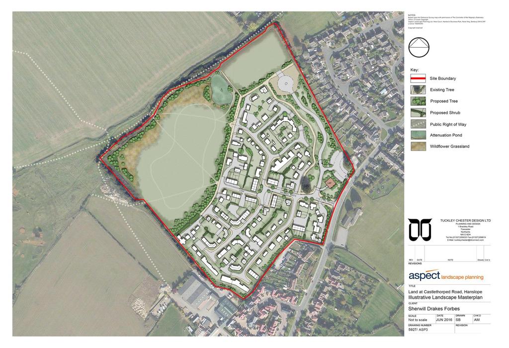
19
20 Appendix to 16/02106/OUT A1.0 RELEVANT PLANNING HISTORY (A brief outline of previous planning decisions affecting the site this may not include every planning application relating to this site, only those that have a bearing on this particular case) A1.1 09/01595/FUL ERECTION OF COMMERCIAL STABLES PER /00749/FUL Change of use from Agriculture to light industry (use class B1c) (Retrospective) PER /01892/DISCON Details submitted pursuant to discharge of Conditions 2 (Landscaping Scheme) and 5 (Foul and Surface Water Drainage) attached to application 09/01595/FUL DTAPP /03291/EIASCR Environmental screening opinion request for application 16/02106/OUT, Castlethorpe Road, Hanslope. PDE A2.0 ADDITIONAL MATTERS A2.1 None. (Matters which were also considered in producing the Recommendation)
21 A3.0 CONSULTATIONS AND REPRESENTATIONS (Who has been consulted on the application and the responses received. The following are a brief description of the comments made. The full comments can be read via the Council s web site) Comments A3.1 Cllr A Geary no comments received. Cllr Green no comments received. Cllr Patey-Smith no comments received. A3.2 Castlethorpe Parish Council Officer Response Noted. Noted. Object to this application on the following grounds: 1. Education a significant development such as this would put at risk the placement of pupils of age 7+ at Hanslope Primary School. 2. Traffic the addition of up to 150 new homes would significantly increase traffic though the village. Given the location of the development it is probable that the vast majority of traffic to Milton Keynes would route through Castlethorpe. 3. Health the addition of a large number of new homes would put pressure on the Hanslope surgery and would adversely affect the availability of doctors at the practice. 4. A3.3 Environmental Health Officer Suggested conditions have been provided and attached. In accordance with NPPF and on the basis of the information provided in the Phase 1 report provided with the
22 application, as the proposed use is particularly vulnerable to the presence of contamination. Suggested conditions have been provided and attached. A3.4 Hanslope Parish Council Noted. 16/02106/OUT Parish Council objection. The Parish Council would like to object to planning application 16/02106/OUT on several points, the most significant of which falls under the heading deficiencies in local amenities. There is considerable concern that the village will not be able to cope with the addition of such a large development. There are insufficient number of school places to cope with the anticipate influx of families, the local GP practice, it appears, would not be able to cope either - residents have reported day to day issues with regard to obtaining appointments etc. A3.5 Highways issues The Local NAG group have commented that the traffic figure quoted in the application do not represent reality, it records between 6 and 7 thousand vehicles on an average day with significant traffic issues at peak times and parking around the shops and church already causes chaos, the village simply would not cope with another 150+ vehicles. A3.6 Loss of Outlook Whilst we appreciate we are unable to object on the grounds of loss of view we would request that you consider the loss of a heritage view. The pictures taken by the developer does not do justice to the reality of the outlook and we would urge you to visit the site.
23 A3.7 Density The Parish Council consider that the number of dwellings proposed for this site is excessive and the amount of land suggested for each house does not fit well with the rest of the village. We would also like to draw your attention to the fact that allowing this development would increase the number of houses in the village by in excess of 10%. A3.8 Drainage The Parish Council would like to express concern that the suggested attenuation pond is insufficient to cope considering the proposed number of dwellings. A3.9 Ecology The Parish Council would like to request reconsideration of the ecological report as there have been reports of bats in the area. A3.10 Anglian Water Noted and see attached Condition. The sewerage system at present has available capacity for these flows. If the developer wishes to connect to our sewerage network they should serve notice under Section 106 of the Water Industry Act From the details submitted to support the planning application the proposed method of surface water management does not relate to Anglian Water operated assets. As such, we are unable to provide comments on the suitability of the surface water management. Anglian Water would therefore recommend the following planning condition if the Local Planning Authority is mindful to grant planning approval.
24 A3.11 Housing Strategy Noted. Housing s view is: 1) The development requires 30% Affordable Housing units as per the Local Plan Policy H4 and the Affordable Housing SPD ) The Council s Plan approved at Council 8 June 2016 has the Key Priority: Housing - supporting work on a progressive Plan:MK focused on affordable housing, economic growth, investment and future prosperity of Milton Keynes for everyone and more strongly implementing the current 30% affordable housing requirement for new homes and to review that percentage in line with current needs; 3) The application proposes in the Affordable Housing Statement, Para 4, to deliver 50 (33.3%) Affordable Housing units which more than satisfies this requirement. 4) The proposed Tenure Mix is 25.3% Affordable Rent (which should be at a range of rental levels up to 80% including 5% at a level broadly equivalent to Social Rent) and 8% Shared Ownership. For this application, the mix breaks down to 38 Affordable Rent and 12 Shared Ownership which more than satisfies the Affordable Housing requirement. 5) The proposed Affordable Housing house size mix should be in line with current affordable housing need and
25 policy; predominantly 2bed, and then a mix of 3bed, 1bed and 4bed properties as appropriate for the site and development. 6) The Affordable Housing should be pepper potted through the site and not concentrated in one particular area. The Council needs Affordable housing for Rent for households in housing need it had 506 households placed in temporary accommodation of which 178 were in B&B at 28 August Confirmation of the Affordable Housing mix and location should be provided with the detailed planning application. A3.12 Natural England Noted. No comments. A3.13 Bedford Group of Drainage Boards (River Ouzel Internal Drainage Board) Noted. No comments. A3.14 Ramblers Association Several public rights of way exist in the proposed site. In particular, footpaths Hanslope 54 and 61 are important links in the footpath network. It is not clear to me what the outline proposal and what are the plans for ensuring that these links are maintained. Noted and the statement below has been provided as part of the application submission. It is considered that the two Public Right of Way diversions which pass through the proposed residential development will be contained within a high quality street scene comprising avenue tree planting. Diverting Public Rights of Way through the proposed development allows for an enhanced level of connectivity between the proposed residents and the wider village setting and countryside setting to the south east and north west respectively.
26 A3.15 Passenger Transport Strong foot path links need to be established to connect residents with the existing upgraded bus stop infrastructure on Castlethorpe Road, enabling use of the Service 33. Potential funding would be requested to enhance AM/PM peak work journeys into CMK/Northampton for new residents. A3.16 Urban Design Noted and see A3.14 Noted. No elevations are currently indicated, however the scheme needs to achieve character in townscape and landscape by identifying and reinforcing better quality and locally distinctive design elements and the proposed development needs to relate well to and enhance the surrounding environment. Where there is no clear character on the site or surrounding area, new development must be designed to create a distinctive sense of place by using existing site features, the layout of the development, and the appearance of buildings. A3.17 Again from the illustrative layout it is difficult to make a judgment at this stage. However it is important to consider a quality public realm consisting of spaces and streets that are accessible, attractive, well related to and overlooked by buildings providing natural surveillance, with active ground floor uses along main streets and with parked vehicles not being visually dominant. The development also needs to have regard to the need to design layout and screening in the interests of the prevention of crime and the surveillance of the public realm.
27 A3.18 The built form should be in scale with other buildings in the immediate vicinity in terms of their height and massing, except where a greater scale is necessary to reflect the development s function and importance. There will be no unacceptable visual intrusion or loss of privacy, sunlight and daylight. A3.19 The proposed layout is based on a series of cul-de-sacs, whilst I don t object to the use of cul-du-sacs, in this instance the amount of dead end streets results in a layout that is difficult to navigate, with a lack of street hierarchy and poor connectivity. The nature of the site results in limited opportunities to connect the development to the existing residential community. However where there are opportunities to strengthen existing connections they don t seem to have been exploited. The proposed LAP should be located within the development or within the proposed open space, as there is already a well-equipped play area on the opposite side of Castlethorpe Road. The illustrative layout indicates a number parking courts these are only recommended where there is no alternative parking solution, as parking at the rear is less convenient than parking to the front of the dwelling and results in additional parking pressure on the street. A3.20 The rear of dwellings along Western Drive are left exposed to a proposed street this potentially provides undesirable access to the rear of dwellings and may leave messy rear boundaries exposed to the public realm / street. The rear of existing dwellings must be secure, ideally by backing proposed dwellings onto them. The access road for the park is isolated from the residential part of the development.
Mid Suffolk District Council Planning Control Department 131 High Street Needham Market IP6 8DL
 Mid Suffolk District Council Planning Control Department 131 High Street Needham Market IP6 8DL OUTLINE PLANNING PERMISSION Town and Country Planning Act 1990 THE TOWN AND COUNTRY PLANNING (DEVELOPMENT
Schedule of Planning Applications Committee Date: 23 May Reference: 06/17/0726/F Parish: Hemsby Officer: Mr J Beck Expiry Date:
 Schedule of Planning Applications Committee Date: 23 May 2018 Reference: 06/17/0726/F Parish: Hemsby Officer: Mr J Beck Expiry Date: 22-05-2018 Applicant: Proposal: Site: Mr Gillett Change of use to the
Report Author/Case Officer: Paul Keen Senior Planning Officer (Dev Control) Contact Details:
 Contact Details:") APP 03 Application Number: 17/02060/FUL Description A full planning application for the demolition of an existing bungalow (C3 use class) and associated out buildings and the erection of two, two storey
APP 03 Application Number: 17/02060/FUL Description A full planning application for the demolition of an existing bungalow (C3 use class) and associated out buildings and the erection of two, two storey
Outline planning permission including means of access (all other matters reserved) for the erection of 14 new dwellings
 for the erection of 14 new dwellings") APP 02 Application Number: 16/01630/OUT Major Outline planning permission including means of access (all other matters reserved) for the erection of 14 new dwellings AT Land East of Castle Road And North
APP 02 Application Number: 16/01630/OUT Major Outline planning permission including means of access (all other matters reserved) for the erection of 14 new dwellings AT Land East of Castle Road And North
Report Author/Case Officer: Joanne Horner Contact Details:
 APP 04 Application Number: 16/00140/FUL Other Two storey side extension to existing dwelling and formation of hard standing to provide parking for number 54 (Resubmission of withdrawn application 15/02852/FUL)
SOUTH CAMBRIDGESHIRE DISTRICT COUNCIL. REPORT TO: Planning Committee 1 April 2015 Planning and New Communities Director
 SOUTH CAMBRIDGESHIRE DISTRICT COUNCIL REPORT TO: Planning Committee 1 April 2015 AUTHOR/S: Planning and New Communities Director Application Number: Parish(es): Proposal: Site address: Applicant(s): Recommendation:
CA//16/00504/FUL. Canterbury City Council Military Road Canterbury Kent CT1 1YW. Crown copyright and database rights 2016 Ordnance Survey
 O Scale 1:1,250 Map Dated: 09/05/2016 CA//16/00504/FUL Crown copyright and database rights 2016 Ordnance Survey 100019614 Canterbury City Council Military Road Canterbury Kent CT1 1YW AGENDA ITEM NO 13
1 The development hereby permitted shall be carried out in accordance with the following approved plans:
 Location The Avenue Tennis Club The Avenue London N3 2LE Reference: 16/6509/FUL Received: 10th October 2016 Accepted: 10th October 2016 Ward: Finchley Church End Expiry 5th December 2016 Applicant: Mrs
Departure from the Development Plan. Town Council objection to a major application. DETERMINE
 Item No. 9 APPLICATION NUMBER CB/17/01642/OUT LOCATION Land rear of 43 to 91 Silver Birch Avenue South of Alder Green and Aspen Gardens, Aspen Gardens, Stotfold PROPOSAL Outline application for up to 95
Description Details submitted pursuant to discharge of condition 5 (Design Code) attached to planning permission 13/01729/OUT.
 attached to planning permission 13/01729/OUT.") ITEM 9 Application Number: 18/00266/DISCON Description Details submitted pursuant to discharge of condition 5 (Design Code) attached to planning permission 13/01729/OUT. AT The Point, 602 Midsummer Boulevard,
ITEM 9 Application Number: 18/00266/DISCON Description Details submitted pursuant to discharge of condition 5 (Design Code) attached to planning permission 13/01729/OUT. AT The Point, 602 Midsummer Boulevard,
an Inspector appointed by the Secretary of State for Communities and Local Government
 Appeal Decision Site visit made on 14 July 2015 by I Radcliffe BSc(Hons) MCIEH DMS an Inspector appointed by the Secretary of State for Communities and Local Government Decision date: 18 August 2015 Appeal
SUBJECT TO ATTACHED SCHEDULE OF THIRTY SIX CONDITIONS
 Stratton House 58/60 High West Street Dorchester Dorset DT1 1UZ Duchy of Cornwall Poundbury Farmhouse Poundbury Farm Way Poundbury Dorchester DT1 3RT Tel: (01305) 251010 Fax: (01305) 251481 Minicom: (01305)
SOUTH CAMBRIDGESHIRE DISTRICT COUNCIL. Executive Director (Operational Services) Corporate Manager (Planning and New Communities)
 Corporate Manager (Planning and New Communities)") SOUTH CAMBRIDGESHIRE DISTRICT COUNCIL REPORT TO: Planning Committee 12 January 2011 AUTHOR/S: Executive Director (Operational Services) Corporate Manager (Planning and New Communities) Notes: S/1848/10
SOUTH CAMBRIDGESHIRE DISTRICT COUNCIL REPORT TO: Planning Committee 12 January 2011 AUTHOR/S: Executive Director (Operational Services) Corporate Manager (Planning and New Communities) Notes: S/1848/10
Reserved Matters application for a site that straddles the boundary between CBC and BBC
 BBC APPLICATION 15/02682/MAR NUMBER CBC APPLICATION CB/15/04294/RM NUMBER LOCATION Wixams Land at former storage depot, Bedford Road, Wilstead Bedfordshire PROPOSAL Reserved Matters Application for Strategic
DUNSFOLD NEIGHBOURHOOD PLAN Site Selection Policies
 DUNSFOLD NEIGHBOURHOOD PLAN Site Selection Policies The criteria for assessing sites for future housing and business development in Dunsfold are set out below. (Development criteria, covering what it is
AT Land North And West of Wavendon Business Park, Ortensia Drive, Wavendon Gate
 APP 02 Application Number: 15/02337/OUT Major Outline application for up to 134 residential units, 75-100 sqm of A1 (retail use) for the provision of a local convenience store with access from Ortensia
Parish: Bradwell Parish Council
 APP 02 Application Number: 16/01475/FUL Demolition of existing public house and erection of 27 dwellings, two storey D1 use building for a nursery and associated car parking to east of St Augustines Church
Application Recommended for Approval Hapton with Park Ward
 Application Recommended for Approval Hapton with Park Ward APP/2017/0036 Outline Planning Application Outline application for the construction of a new 3 bedroom dwelling (with all matters reserved for
Planning Area Committee 25 June 2018 Addendum to Officers Report RESTRICTION OF PERMITTED DEVELOPMENT RIGHTS - EXTENSIONS
 Planning Area Committee 25 June 2018 Addendum to Officers Report 17/8150/RMA West Hendon Regeneration Area (Phase 6) Pages 11 54 The conditions section shall be changed as follows: RESTRICTION OF PERMITTED
Stantonbury Neighbourhood Plan
 Stantonbury Neighbourhood Plan 2018-2031 Basic Conditions Statement October 2018 Intentionally blank 1.0 Basic Conditions Statement Introduction 1.1 This statement has been prepared by Stantonbury Parish
OKEFORD FITZPAINE NEIGHBOURHOOD PLAN
 OKEFORD FITZPAINE NEIGHBOURHOOD PLAN Dear Parishioner, The Neighbourhood Plan Project Team have prepared this leaflet to summarise the full Neighbourhood Plan document. It provides a summary of the Vision,
Outh SOUTH CAMBRIDGESHIRE DISTRICT COUNCIL. Joint Director for Planning and Economic Development S/0179/18/OL. Histon. Approval.
 Outh SOUTH CAMBRIDGESHIRE DISTRICT COUNCIL REPORT TO: Planning Committee 4 April 2018 AUTHOR/S: Joint Director for Planning and Economic Development Application Number: Parish(es): Proposal: Site address:
DONCASTER METROPOLITAN BOROUGH COUNCIL. PLANNING COMMITTEE - 15th October Expiry Date:
 DONCASTER METROPOLITAN BOROUGH COUNCIL PLANNING COMMITTEE - 15th October 2013 Application 3 Application Number: 13/01158/FUL Application Expiry Date: 31st July 2013 Application Type: Full Application Proposal
Committee Report. Case Officer: Gemma Walker. Ward: Bacton & Old Newton. Ward Member/s: Cllr Jill Wilshaw.
 Committee Report Item No: 1 Ward: Bacton & Old Newton. Ward Member/s: Cllr Jill Wilshaw. Reference: DC/17/05423 Case Officer: Gemma Walker Description of Development Outline planning application (all matters
Report Author/Case Officer: Debbie Kirk Contact Details:
 APP 01 Application Number: 14/00350/OUTEIS MAJOR A residential development for up to 400 dwellings, together with formal and informal open space, amenity space, retained vegetation, structural landscaping,
Garages To Rear Of The Willows 1025 High Road London N20 0QE
 Location Garages To Rear Of The Willows 1025 High Road London N20 0QE Reference: 15/03944/FUL Received: 25th June 2015 Accepted: 2nd July 2015 Ward: Totteridge Expiry 27th August 2015 Applicant: Mr Alex
Great Easton Neighbourhood Plan Statement of Basic Conditions
 Great Easton Neighbourhood Plan 2017-2031 Statement of Basic Conditions OCTOBER 2016 GREAT EASTON PARISH COUNCIL Contents 1.0 Introduction....Page 2 2.0 Summary of Submission Documents and Supporting Evidence..
Construction of 9 dwellings and associated infrastructure.
 Application Number 16/00653/FUL Proposal Site Applicant Recommendation Construction of 9 dwellings and associated infrastructure. Land at Grange Road South, Hyde McDermott Developments Ltd Approve REPORT
SOUTH CAMBRIDGESHIRE DISTRICT COUNCIL. Planning and New Communities Director. Linton. Yes
 SOUTH CAMBRIDGESHIRE DISTRICT COUNCIL REPORT TO: Planning Committee 2 July 2014 AUTHOR/S: Planning and New Communities Director Application Number: Parish(es): Proposal: Site address: Applicant(s): Recommendation:
Site Assessment Technical Document Appendix A: Glossary
 Central Bedfordshire Council www.centralbedfordshire.gov.uk Site Assessment Technical Document Appendix A: Glossary July 2017 1.1.11-1 - ii Appendix A: Glossary Term Agricultural Land Classification AONB
Plumpton Neighbourhood Development Plan Revised Pre Submission Document - Regulation 14 Consultation
 REPRESENTATIONS... Plumpton Parish Council Plumpton Neighbourhood Development Plan Revised Pre Submission Document - Regulation 14 Consultation Representations submitted on behalf of: Cala Homes (South
PLANNING COMMITTEE REPORT
 PLANNING COMMITTEE REPORT TO: BY: Planning Committee South Head of Development DATE: 19 December 2017 DEVELOPMENT: SITE: WARD: APPLICATION: APPLICANT: Conversion of existing water storage reservoir to
Reference: 16/1447/FUL Received: 7th March 2016 Accepted: 7th March 2016 Ward: East Finchley Expiry 2nd May 2016
 Location 374B Long Lane London N2 8JX Reference: 16/1447/FUL Received: 7th March 2016 Accepted: 7th March 2016 Ward: East Finchley Expiry 2nd May 2016 Applicant: Ms Katrin Hirsig Proposal: Single storey
Copyright Nigel Deeley and licensed for reuse under this Creative Commons Licence
 1 Copyright Nigel Deeley and licensed for reuse under this Creative Commons Licence Prepared by the Neighbourhood Plan Steering Group on behalf of Garway Parish Council with assistance from 2 Table of
Land at Rampton Road. Cottenham
 Land at Rampton Road Cottenham Introduction TEP is preparing an outline planning application for 54 dwellings on 6.9 hectares of land adjacent to Rampton Road, Cottenham on behalf of the owners Cambridgeshire
26 September 2014 CONSULTATION EXPIRY : APPLICATION EXPIRY : 22 July 2014 SUMMARY RECOMMENDATION: PERMISSION
 Item No.: 5 The information, recommendations and advice contained in this report are correct as at the date of preparation, which is more than one week in advance of the Committee meeting. Because of the
Mr & Mrs Connolly per Pump House Designs Pump House Yard The Green SEDLESCOMBE, East Sussex. TN33 0QA
 AGENDA ITEM NO: 5 (c) Report to: PLANNING COMMITTEE Date: 03 June 2015 Report from: Head of Housing and Planning Services Application Address: Proposal: Application No: Recommendation: Ward: File No: Applicant:
Parish of Repton NEIGHBOURHOOD DEVELOPMENT PLAN
 Parish of Repton NEIGHBOURHOOD DEVELOPMENT PLAN BASIC CONDITIONS STATEMENT December 2018 CEF 4 Legal Requirements This statement has been produced by the NDP Working Group on behalf of Repton Parish Council
It is recommended that the Committee resolve to APPROVE the application and grant planning permission subject to the following conditions:
 LOCATION: Phase 2A Millbrook Park (Site of Former Inglis Barracks), Mill Hill East, London, NW7 1PZ REFERENCE: H/04606/12 Received: 04 December 2012 Accepted: 17 December 2012 WARD: Mill Hill Expiry: 18
Rochford District Council Allocations Development Plan Document: Discussion and Consultation Document Sustainability Appraisal
 Option SWH1 Balanced Communities Option SWH1 1 To ensure the delivery of high quality sustainable communities where people want to live and work Will it ensure the phasing of infrastructure, including
SOUTH CAMBRIDGESHIRE DISTRICT COUNCIL. Planning and New Communities Director
 SOUTH CAMBRIDGESHIRE DISTRICT COUNCIL REPORT TO: Planning Committee 5 June 2013 AUTHOR/S: Planning and New Communities Director S/0747/13/FL HISTON Construction of Car Park at Histon Baptist Church, Station
Derry City and Strabane District Council Planning Committee Report. Amended layout from approval A/2004/0462/F with reduction from 166 units
 Derry City and Strabane District Council Planning Committee Report COMMITTEE DATE: 1 st February 2017 APPLICATION No: APPLICATION TYPE: PROPOSAL: LOCATION: APPLICANT: AGENT: Full Planning application Amended
Ward: West Wittering. Proposal Change of use from public highway pavement to residential garden use.
 Parish: West Wittering Ward: West Wittering WW/17/03295/FUL Proposal Change of use from public highway pavement to residential garden use. Site Izora 1 Watersedge Gardens West Wittering PO20 8RA Map Ref
Derry City and Strabane District Council Planning Committee Report
 Derry City and Strabane District Council Planning Committee Report COMMITTEE DATE: 23 rd March 2016 APPLICATION No: APPLICATION TYPE: PROPOSAL: LOCATION: APPLICANT: LA11/2015/0395/F Residential Development
Kibworth Harcourt. Introduction. Introduction
 Introduction Introduction Welcome to this public exhibition on the proposals for the delivery of new homes on land at The Kibworths. The purpose of today s exhibition is to give you the opportunity to
Demolition of The Suffolk Punch Public House and clearing of the site including the car park and associated works. Parish: Bradwell Parish Council
 APP 01 Application Number: 15/01914/FUL Demolition of The Suffolk Punch Public House and clearing of the site including the car park and associated works. AT The Suffolk Punch, 1 Langcliffe Drive, Heelands
EXTRACT FROM THE CUDDINGTON NEIGHBOURHOOD PLAN The Policies
 EXTRACT FROM THE CUDDINGTON NEIGHBOURHOOD PLAN The Policies Environment and Landscape Policy 1 - Landscape Setting Development should respect and wherever possible enhance the landscape setting of Cuddington
Test Valley Borough Council Southern Area Planning Committee 8 January 2019
 ITEM 11 APPLICATION NO. 18/02218/FULLS APPLICATION TYPE FULL APPLICATION - SOUTH REGISTERED 23.08.2018 APPLICANT Rugby Football Union SITE The Trojans Club, Stoneham Lane, Eastleigh, SO50 9HT, CHILWORTH
1 The development hereby permitted shall be carried out in accordance with the following approved plans:
 Location Victoria Park Ballards Lane London N3 Reference: 17/1030/FUL Received: 20th February 2017 Accepted: 20th February 2017 Ward: West Finchley Expiry 17th April 2017 Applicant: Mrs Mia Freedman Proposal:
DEVELOPMENT MANAGEMENT REPORT
 ITEM A07-1 DEVELOPMENT MANAGEMENT REPORT TO: BY: Development Management Committee (South) Development Manager DATE: 21 June 2016 DEVELOPMENT: SITE: WARD: APPLICATION: APPLICANT: Outline application for
PLANNING STATEMENT. Market House Market Place Kingston upon Thames KT1 1JS
 PLANNING STATEMENT To support planning and listed building consent applications for change of use from Class A1 shop and Class A3 cafe to Class A3 restaurant at: Market House Market Place Kingston upon
BLETCHLEY PARK AREA - DEVELOPMENT FRAMEWORK
 ANNEX A To Item 9 REVISED TEXT: additions shown bold and underlined, deletions in (brackets and in italics). BLETCHLEY PARK AREA - DEVELOPMENT FRAMEWORK This framework sets out the key objectives and requirements
Ground Floor Flat 15 Redbourne Avenue London N3 2BP
 Location Ground Floor Flat 15 Redbourne Avenue London N3 2BP Reference: 17/4160/FUL Received: 28th June 2017 Accepted: 29th June 2017 Ward: West Finchley Expiry 24th August 2017 Applicant: Proposal: Mr
Case Officer: Sarah Kay File No: CHE/14/00515/REM Tel. No: (01246) Plot No: 2/6132 Ctte Date: 15 th September 2014 ITEM 1
 Plot No: 2/6132 Ctte Date: 15 th September 2014 ITEM 1") Case Officer: Sarah Kay File No: CHE/14/00515/REM Tel. No: (01246) 345786 Plot No: 2/6132 Ctte Date: 15 th September 2014 ITEM 1 APPROVAL OF RESERVED MATTERS FROM APPLICATION CHE/12/00234/OUT (1) LAYOUT,
Case Officer: Sarah Kay File No: CHE/14/00515/REM Tel. No: (01246) 345786 Plot No: 2/6132 Ctte Date: 15 th September 2014 ITEM 1 APPROVAL OF RESERVED MATTERS FROM APPLICATION CHE/12/00234/OUT (1) LAYOUT,
Newcourt Masterplan. November Exeter Local Development Framework
 Newcourt Masterplan November 2010 Exeter Local Development Framework Background The Exeter Core Strategy Proposed Submission sets out the vision, objectives and strategy for the development of Exeter up
DEVELOPMENT MANAGEMENT REPORT
 ITEM A08-1 DEVELOPMENT MANAGEMENT REPORT TO: BY: DATE: DEVELOPMENT: SITE: WARD: APPLICATION: APPLICANT: Development Management Committee Development Manager Proposed live/work unit in connection with existing
PLANNING COMMITTEE DATE: 07/09/2015 REPORT OF THE SENIOR MANAGER PLANNING AND ENVIRONMENT SERVICE CAERNARFON. Number: 4
 Number: 4 Application Number: C15/0034/37/LL Date Registered: 21/05/2015 Application Type: Full - Planning Community: Llanaelhaearn Ward: Llanaelhaearn Proposal: Location: Summary of the Recommendation:
Report Author/Case Officer: Samantha Taylor Planning Officer Contact Details:
 APP 01 Application Number: 16/03023/FUL Major Demolition of existing B8 storage and distribution warehouse, and erection of a new B8 storage and distribution warehouse with ancillary B1 floorspace and
Statement of Community Involvement LAND OFF SOUTHDOWN ROAD HORNDEAN, HAMPSHIRE
 LAND OFF SOUTHDOWN ROAD HORNDEAN, HAMPSHIRE CONTENTS Page 1. Introduction 3 2. Pre-application Discussions 4 3. The Consultation Process 5 4. Consultation Feedback 7 5. Responses to Consultation Feedback
Planning Committee 04/02/2015 Schedule Item 6. Smith Farm Estate, Old Bridge Close, Northolt, UB5 6UA.
 Planning Committee 04/02/2015 Schedule Item 6 Ref: Address: Ward: Proposal: PP/2014/5145 Smith Farm Estate, Old Bridge Close, Northolt, UB5 6UA. Greenford Broadway Installation of sports pitch, reconstruction
Welcome. Site/11/04. Site/11/03. Proposed Site. 11,400 new homes needed in east Cambs
 Welcome Welcome to our consultation on our proposals for new homes on land north east of Soham Road, Fordham. Members of the project team are available to answer any questions you have and listen to feedback.
SOUTH CAMBRIDGESHIRE DISTRICT COUNCIL. Planning and New Communities Director
 SOUTH CAMBRIDGESHIRE DISTRICT COUNCIL REPORT TO: Planning Committee 9 January 2013 AUTHOR/S: Planning and New Communities Director S/2064/12/FL WATERBEACH Demolition of existing 35 no. shared amenity apartments
an Inspector appointed by the Secretary of State for Communities and Local Government
 Appeal Decision Site visit made on 11 October 2016 by Mike Hayden BSc DipTP MRTPI an Inspector appointed by the Secretary of State for Communities and Local Government Decision date: 21 November 2016 Appeal
DELEGATED DECISION on 1st September 2015
 Application N o : 14/04810/OUT LONDON BOROUGH OF BROMLEY TOWN PLANNING RENEWAL AND RECREATION DEPARTMENT DELEGATED DECISION on 1st September 2015 14/04810/OUT Claire Harris 4 Oaklands Road Bromley BR1
SITE ASSESSMENT CHECKLIST
 1. Site Details a. What is the site s name/reference? SITE ASSESSMENT CHECKLIST CR3NPWHY 3007 Gasometer Site Godstone Road CR3 0EG b. Where is the site located? Wyhteleafe; Godstone Road. Urban category1
2014/0590 Reg Date 26/06/2014 Chobham
 2014/0590 Reg Date 26/06/2014 Chobham LOCATION: PROPOSAL: TYPE: APPLICANT: OFFICER: ASCOT PARK POLO CLUB, WESTCROFT PARK FARM, WINDLESHAM ROAD, CHOBHAM, WOKING, GU24 8SN Erection of a two storey detached
SOUTH CAMBRIDGESHIRE DISTRICT COUNCIL. Planning and New Communities Director
 SOUTH CAMBRIDGESHIRE DISTRICT COUNCIL REPORT TO: Planning Committee 9 January 2013 AUTHOR/S: Planning and New Communities Director S/2270/12/FL FEN DRAYTON 850m long flood defence embankment ranging in
Welcome to our exhibition
 Welcome to our exhibition The Homes & Communities Agency (HCA) welcomes you to this public exhibition explaining our proposals for the redevelopment of the former Lea Castle Hospital site. About the Homes
1 The development hereby permitted shall be carried out in accordance with the following approved plans:
 Location 59 Greenway Close London N20 8ES Reference: 16/00011/HSE Received: 30th December 2015 Accepted: 7th January 2016 Ward: Totteridge Expiry 3rd March 2016 Applicant: Mr Ankit Shah Proposal: Part
3 Abbey View Mill Hill London NW7 4PB
 Location 3 Abbey View Mill Hill London NW7 4PB Reference: 15/03203/HSE Received: 26th May 2015 Accepted: 16th June 2015 Ward: Mill Hill Expiry 11th August 2015 Applicant: Proposal: Mr Richard Benson Alterations
18 Birkbeck Road London NW7 4AA. Reference: 15/02994/HSE Received: 14th May 2015 Accepted: 26th May 2015 Ward: Mill Hill Expiry 21st July 2015
 Location 18 Birkbeck Road London NW7 4AA Reference: 15/02994/HSE Received: 14th May 2015 Accepted: 26th May 2015 Ward: Mill Hill Expiry 21st July 2015 Applicant: Proposal: Mrs Tania Kallis Single storey
SOUTH CAMBRIDGESHIRE DISTRICT COUNCIL. Director of Development Services
 SOUTH CAMBRIDGESHIRE DISTRICT COUNCIL REPORT TO: Development and Conservation Control Committee 5 th April 2006 AUTHOR/S: Director of Development Services S/2290/05/F Haslingfield House (Revised Design)
APPLICATION REFERENCE: PL/2016/02759/PPFL
 APPLICATION REFERENCE: PL/2016/02759/PPFL Site Address: Land Adjacent To Mount Farm Tanworth Lane, Chewisck Green. Proposal: Erection of 54 dwellings following the granting of outline permission 2014/1163/S
Introduction. Grounds of Objection
 Planning application ref. number 18/04496/APP Planning application to Aylesbury Vale District Council for the erection of 17 dwellings and associated works to the South of Hogshaw Road Granborough. Granborough
Site north of Hattersley Road West (east of Fields Farm Road), Hattersley
, Hattersley") Application Number 17/00982/REM Proposal Site Applicant Recommendation Reason for report Application for the approval of reserved matters (means of access, landscaping, layout, scale and appearance) relating
Application Number 17/00982/REM Proposal Site Applicant Recommendation Reason for report Application for the approval of reserved matters (means of access, landscaping, layout, scale and appearance) relating
REFERENCE: 15/01661/FUL Registered: 16 March 2015 Expiry date: 25 October 2016
 LOCATION: Land North Of Charcot Road, Colindale REFERENCE: 15/01661/FUL Registered: 16 March 2015 Expiry date: 25 October 2016 WARD: Colindale APPLICANT: PROPOSAL: Fairview New Homes (Colindale) Ltd Erection
49 Broughton Avenue London N3 3EN
 Location 49 Broughton Avenue London N3 3EN Reference: 17/3448/RCU Received: 30th May 2017 Accepted: 1st June 2017 Ward: Finchley Church End Expiry 27th July 2017 Applicant: Mr P Atwal Proposal: Erection
Town And Country Planning Act 1990 (As Amended) Town And Country Planning (General Development Procedure) Order 1995
 Town And Country Planning (General Development Procedure) Order 1995") Cornwall Council Council Offices St Clare Penzance TR18 3QW Tel: 01736 331166 Email: planning.west1@cornwall.gov.uk Web: www.cornwall.gov.uk Agent: Mr Paul Connelly LDA Design Kings Wharf The Quay Exeter
Cornwall Council Council Offices St Clare Penzance TR18 3QW Tel: 01736 331166 Email: planning.west1@cornwall.gov.uk Web: www.cornwall.gov.uk Agent: Mr Paul Connelly LDA Design Kings Wharf The Quay Exeter
SOUTH EAST LINCOLNSHIRE LOCAL PLAN: HOUSING PAPER DONINGTON (JUNE 2016)
") SOUTH EAST LINCOLNSHIRE LOCAL PLAN: HOUSING PAPER DONINGTON (JUNE 2016) 1 DONINGTON S PLACE IN THE SPATIAL STRATEGY 1.1 Policy 2 of the South East Lincolnshire Local Plan 2011-2036 Draft for Public Consultation
SOUTH EAST LINCOLNSHIRE LOCAL PLAN: HOUSING PAPER DONINGTON (JUNE 2016) 1 DONINGTON S PLACE IN THE SPATIAL STRATEGY 1.1 Policy 2 of the South East Lincolnshire Local Plan 2011-2036 Draft for Public Consultation
Briefing Document of CNP. June 2017
 Cholsey Parish Council Cholsey Neighbourhood Plan Briefing Document of CNP June 2017 Cholsey Neighbourhood Plan Page! 1 of! 8 Cholsey Plan Briefing v1.4 Page Left Intentionally Blank Cholsey Neighbourhood
REFERENCE: B/03745/12 Received: 02 October 2012 Accepted: 05 October 2012 WARD(S): Totteridge Expiry: 30 November 2012.
: Totteridge Expiry: 30 November 2012.") LOCATION: 15A Pyecombe Corner, London, N12 7AJ REFERENCE: B/03745/12 Received: 02 October 2012 Accepted: 05 October 2012 WARD(S): Totteridge Expiry: 30 November 2012 Final Revisions: APPLICANT: PROPOSAL:
LOCATION: 15A Pyecombe Corner, London, N12 7AJ REFERENCE: B/03745/12 Received: 02 October 2012 Accepted: 05 October 2012 WARD(S): Totteridge Expiry: 30 November 2012 Final Revisions: APPLICANT: PROPOSAL:
Committee Report. Committee Date: 23 February Item No: 3 Reference: 4242/16 Case Officer: DYJO
 Committee Report Committee Date: 23 February 2017 Item No: 3 Reference: 4242/16 Case Officer: DYJO Description of Development: Application for Outline Planning Permission (include access only) for the
Perth and Kinross Council Development Management Committee 8 June Pre-Application Report by Development Quality Manager
 Perth and Kinross Council Development Management Committee 8 June 2016 5(3)(i) 16/259 Pre-Application Report by Development Quality Manager Residential development at St Martins Road, Land 120 metres West
Site Address: Site Accessed off Bondfield Close, Bondfield Crescent, Wombwell, Barnsley, S73 8TX
 2017/0155 Applicant: Craig Hawley, Gleeson Regeneration Ltd Description: Residential development of 49 no dwelling houses. Site Address: Site Accessed off Bondfield Close, Bondfield Crescent, Wombwell,
APPLICATION ITEM LW/17/0325 NUMBER: NUMBER: 8 APPLICANTS. PARISH / Peacehaven / P L Projects NAME(S):
:") APPLICATION ITEM LW/17/0325 NUMBER: NUMBER: 8 APPLICANTS PARISH / Peacehaven / P L Projects NAME(S): WARD: Peacehaven North Planning Application for Demolition of the existing bungalow and PROPOSAL: erection
APPLICATION ITEM LW/17/0325 NUMBER: NUMBER: 8 APPLICANTS PARISH / Peacehaven / P L Projects NAME(S): WARD: Peacehaven North Planning Application for Demolition of the existing bungalow and PROPOSAL: erection
LAND & DEVELOPMENT OFFICE. 170 Church Road, Hove, BN3 2DJ mishonmackay.com
 LAND & DEVELOPMENT OFFICE 170 Church Road, Hove, BN3 2DJ 01273 829300 land@mishonmackay.com mishonmackay.com APPLICATION NUMBER: APPLICANTS NAME(S): PROPOSAL: LW/15/0462 Seaview Developments ( Sussex )
STATEMENT OF OBJECTION TO THE PROPOSED DEVELOPMENT OF LAND AT CHURCH CLIFF DRIVE FILEY
 STATEMENT OF OBJECTION TO THE PROPOSED DEVELOPMENT OF LAND AT CHURCH CLIFF DRIVE FILEY You will be aware that Scarborough borough council have adopted a new local plan that includes land at Church Cliff
Town Council. Report Author/Case Officer: Alex Harrison Contact Details:
 Application Number: 09/00330/FUL ERECTION OF TWO STOREY SIDE EXTENSION AT The Pink Punters, 2 Watling Street, Fenny Stratford FOR Mr F McMahon Target: 27th April 2009 Ward: Bletchley And Fenny Stratford
Planning and Regulatory Committee 20 May Applicant Local Councillor Purpose of Report
 Planning and Regulatory Committee 20 May 2014 7. APPLICATION FOR PLANNING PERMISSION FOR THE CARRYING-OUT OF DEVELOPMENT PURSUANT TO PLANNING PERMISSION REFERENCE NUMBER 603451 DATED 28 FEBRUARY 2007 WITHOUT
WELCOME GYPSY LANE. Wider Site Location plan. Proposals for the development of LAND OFF FOXLYDIATE LANE WEBHEATH. Proposals for the development of
 WELCOME The developers are preparing an outline planning application for a residential led development and need the community s views in order to develop the proposals further WHAT IS PROPOSED? A high
UTT/17/2075/FUL - (BERDEN) (Referred to Committee by Councillor Janice Loughlin. Reason: In the Public Interest)
 (Referred to Committee by Councillor Janice Loughlin. Reason: In the Public Interest)") UTT/17/2075/FUL - (BERDEN) (Referred to Committee by Councillor Janice Loughlin. Reason: In the Public Interest) PROPOSAL: LOCATION: APPLICANT: Amendments to the design of a scheme for a 49.99MW battery
UTT/17/2075/FUL - (BERDEN) (Referred to Committee by Councillor Janice Loughlin. Reason: In the Public Interest) PROPOSAL: LOCATION: APPLICANT: Amendments to the design of a scheme for a 49.99MW battery
PLANNING DECISION NOTICE
 PLANNING DECISION NOTICE TOWN AND COUNTRY PLANNING ACT, 1990 Applicant WILLITON VILLAGE HALL STEERING COMM. C/O ALISON CALLOWWAY 54 NORTHCROFT WILLITON TAUNTON TA4 4RT Date Registered 11/08/2006 Application
PHASE III: Reserved Matters Submission
 Statement of Compliance with the outline approval for the proposed residential development of land at: BURGES LANE, WIVELISCOMBE PHASE III: Reserved Matters Submission Foreword Contents: This Statement
Site: Essex Police & La Plata House London Road Brentwood Essex CM14 4QJ
 Reference: 16/01805/OUT Ward: Brentwood West Site: Essex Police & La Plata House London Road Brentwood Essex CM14 4QJ Proposal: Outline application for demolition of existing police station buildings,
Public Consultation. Land at Monks Farm, North Grove. Welcome
 Welcome Welcome to our public exhibition for development on Land at Monks Farm, orth Grove. Gallagher Estates and Gleeson Strategic Land are preparing an outline planning application for new homes, open
3. Neighbourhood Plans and Strategic Environmental Assessment
 1. Introduction This report sets out a draft Screening Determination for the Preston Parish Council s Neighbourhood Plan and has been prepared by rth Hertfordshire District Council. The purpose of the
Site ref: AS06 Site Name or Address: Murreys Court, Agates Lane
 Site ref: AS06 Site Name or Address: Murreys Court, Agates Lane Proposed Land Use: Total Site Area (Ha): Housing 1.85 Ha Description: It is understood that the owner has no plans to dispose of the site
PLANNING COMMITTEE REPORT
 PLANNING COMMITTEE REPORT TO: BY: Planning Committee South Head of Development DATE: 21 August 2018 DEVELOPMENT: SITE: WARD: APPLICATION: APPLICANT: Erection of a new chalet bungalow with associated parking
Derry City and Strabane District Council Planning Committee Report
 Derry City and Strabane District Council Planning Committee Report COMMITTEE DATE: 20.12.2017 APPLICATION No: APPLICATION TYPE: PROPOSAL: LOCATION: APPLICANT: AGENT: A/2014/0495/F Full Construction of
Neighbourhood Plan Representation
 Date: 10 th November 2017 Neighbourhood Plan Representation Land to the east of Callow Hill Road, Alvechurch Introduction This representation has been prepared by RPS Planning and Development on behalf