DRAFT/02. Our Place. Westbury-on-Trym. City Design Group. July 2013 City Design Group
|
|
|
- Loren Lamb
- 5 years ago
- Views:
Transcription


1 DRAFT/02 City Design Group
2
3 Contents Preface 1. Introduction 2. Character and distinctiveness 3. Character Areas 1 Henbury Road environs 2 Commercial core 3 College and Church Road environs 4 Channell s Hill and landscape setting 5 Historic village 6 Church and setting 7 Southfield Road environs 8 Westbury Road and Waters Lane 4. Strengths and challenges Appendix 1: community mapping This document has been produced by Peter Insole, Senior Archaeological Officer, No portion of this document can be reproduced without the permission of, Neighbourhoods and City Development, Bristol City Council Crown Copyright and database rights 2013 Ordnance Survey Cover image Blom Pictometry
4 Preface Understanding the context of our place... The City of Bristol is one of the most historic cities in England. Founded in about 1000AD the city has always been a place of change, economic growth and innovation. Until the First World War the fabric of the city was essentially a medieval structure centred on the cross roads of High Street, Corn Street, Broad Street and Wine Street. Even the outer structure of the city, now the inner suburbs such as St Pauls and Kingsdown, was based on medieval routes or field patterns. Despite centuries of urban growth and densification this structure remained unchanged while building forms adapted to new uses and new architectural styles. During the twentieth century Bristol has seen its most dramatic changes with the depopulation of the central core, bombing during the Second World War and the dominance of private motor car use. Although this period has continued the process of urban renewal and the replacement of built form it is the Post War highway infrastructure projects that have eroded the physical fabric of the city on a scale unlike any other period. Within this broad context, Bristol s character is defined by a variety of distinct neighbourhoods and designated Conservation Areas - areas with a distinctive character informed by their topography, landscape, views, layout, land use and social development, arhitectural style and materials. A Character Appraisal is intended to help to explain how a specific conservation area has arrived at its current state from its origins, and highlighting the key features that define the area as it exists today. This understanding provides the basis from which appropriate changes to the area can be achieved, which will enable to grow and succeed whilst still respecting its historic legacy and unique sense of place. Ultimately it will help to deliver local plan policies particularly around issues concerning local character and distinctiveness. The process encourages greater participation by communities in defining the character of their neighbourhood and planning for the future of their place. 2
5 Introduction 1 33
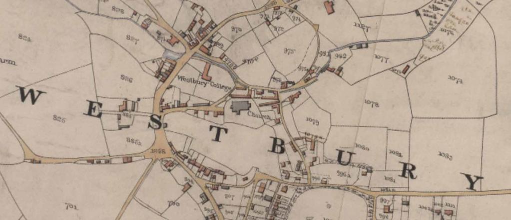
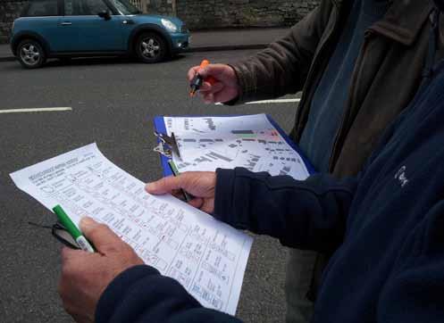
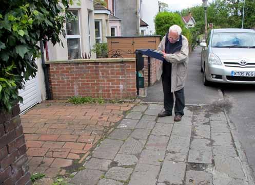
6 Introduction Purpose, scope and status 1.1 Planning Policy Context A Conservation Area is an area of special or historic interest, the character or appearance of which it is desirable to preserve or enhance (Planning Listed Buildings & Conservation Areas Act, 1990). There are currently 33 conservation areas in Bristol, covering approximately 30% of the city. Part of the city council s responsibilities is to set out enhancement proposals for individual conservation areas, adopting policies encouraging their preservation. Since 2008, the city council has been underway reassessing its existing conservation areas and compiling a Character Appraisal to give an up-to-date record of the character and special interest of an area, replacing the 1993 Conservation Area Enhancement Statements (PAN2). The over-arching planning policy is thew National Planning Policy Framework (NPPF), which sets out the Government s planning policies for England and how these are expected to be applied at a local level. Of specific relevance is Section 12: Conserving and enhancing the historic environment. The Core Strategy (June 2011) is the overall approach for planning in Bristol, guiding development and setting out key elements of the planning framework up to 2026 and beyond. The Character Appraisals form part of a suite of guidance documents referred to in Policy BCS21 of the Core Strategy and the Local Character and Distinctiveness policy in the Development Management Policy document. 1.2 Purpose and scope A character appraisal accounts for the need to make informed decisions about the special interest of conservation areas and provides a point of reference for the planning authority, architects and developers and communities in managing change appropriately. The format follows EH guidance Understanding Place: Conservation Area Designation, Appraisal and Management (2010). This approach has been widely accepted, with adopted appraisals having been referenced frequently in planning policy, development management and appeal decisions. This document provides an understanding of why is special and articulates which elements contribute to or detract from its character. To achieve this understanding, the document identifies the physical characteristics of the area defined by the local: Topography Views and vantage points (into, out of and within each area) Landmarks (positive landmarks and other notable features) Routes Spaces Urban structure and grain Scale and massing Building ages Building materials 1.3 In May 2013, a group of residents and community groups carried out an mapping exercise around the Conservation Area. The group worked with Peter Insole and Hannah Porter from Bristol City Council s and Richard Guise and James Webb from Context 4D urban design specialists. For the purposes of the mapping activities the area was divided into ten smaller areas. Using mapping worksheets (Appendix 1) the community participants defined the character of. This information will contribute to the understanding of the area that is being used to inform the update of the Conservation Area Character Appraisal. The results of this project can be used as a material planning consideration in relation to local plan policies on local character and distinctiveness. For further information about the project visit 4


7 Introduction Language of the document Character/context Urban structure Urban grain Built Form The main visual characteristics of an area resulting from the influence of geology, topography, urban layout, plot form, land use, and predominant building ages, types, form and materials. Buildings and structures described using the following terms. Scale Topography The physical form of an area defined by natural features of relief and geographic elements such as rivers. Views The size of a building described in terms of the number of floors. Massing Relates to the building or group of buildings volume or perceived volume as a result of its structural form. Within the scope of this document views are discussed in terms of locations from which a view to a specific landmark, or series of features (natural or built) is possible. Landmarks Are defined as features that make a positive contribution to a view (long distant or local). The description of each character area refers to positive landmarks as well as other features within the area. This latter type are not necessarily visible in a specific view but are of historic interest or make a positive contribution to the local character. The framework of routes and spaces and the way they relate to one another as defined in Cowan, R The Dictionary of Urbanism. The pattern of development in terms of the size of street blocks, building plots and the size of building in relation to its plot as defined in Cowan, R The Dictionary of Urbanism. Materials The context study refers to materials in terms of the predominant building materials used in an area for walling, paving and roofing. Distinctive frontage A structure or series of buildings such as a terrace that has specific architectural quality, recognisable plot rhthym, consistant use of materials or a combination of the above. A distinctive frontage will make a positive contribution to local street character or even define the local character. 5


8 Introduction Fig 1 study area Existing conservation area boundary Proposed extensions Location and boundary review Location is a former village that now lies in the northwest area of the modern city of Bristol. It is adjacent to the suburbs of Henleaze and Southmead to the east and north, Coombe Dingle and Sea Mills lie to the west and the Downs Conservation Area lies to the south. In its current state, the Conservation Area takes within its boundaries the extended village of Westbury grouped around the River Trym, its valley and the road into Bristol from Gloucester, now High Street and Westbury Hill. Boundary Review Undertaking the project has involved consideration into where the boundaries of the conservation area should be drawn. The boundaries proposed in this draft document are the result of the community mapping activity (Appendix 1). On the basis of the mapping acvtivity it is proposed to extend the boundary to the conservation area to include the Southfield Road area and the site of Elmfield Lodge off Passage Road (fig.1). The proposed boundary changes will be consulted on through this draft document and subsequent draft conservation area character appraisal that will be drawn from this material; once finalised and approved, the document and any boundary amendments will be adopted and fromally designated. 6


9 Introduction Fig 2 historic development s Tithe s Epoch 3 Ordnance Survey, 1949 historic development 1840s originated in the early medieval period and is likely to have been the site of a Saxon minster. The 1840s tithe map probably shows the approximate extent and layout of the medieval village. The plan form of the centre of is largely unchanged since the medieval period. 1880s During the Victorian period the key change in the centre of Westbury was the creation of College Road and the terraced housing in the area between the Church and the High Street. The area of Southfield was also created with semi detached villas on Southfield Road and grand terraces at the top of Westbury Hill as well as smaller terraced properties at Bellevue Cottages. A few detached villas at Henbury Road on the fringe of teh historic village had also been constructed by In the early twentieth century the biggest change was the creation of Falcondale Road and the associated housing to the west of the historic core in the 1930s. 7
10 8

11 Character and distinctiveness 2 99

12 Character and distinctiveness Fig 3 Character areas 1 Henbury Road envrons 2 Commercial core 3 College and Church Road environs Local character 4 Channells Hill and Landscape setting 5 Historic village 6 Church and setting 7 Southfield Road environs 8 Westbury Road and Waters Lane 2.3 Summary of local character The original settlement is located along the River Trym and is made up of small vernacular cottages on rural lanes such as Chock Lane and Channels Hill which wind up the steep valley on its eastern boundaries. There are two major early buildings which dominate the character of the area; Westbury Church and Canon s College. A defining character found within the entire area is that of early walls and openings which survived from the medieval developments. There are also unspoilt natural landscapes and features in the area, including the Westbury Wildlife Park, whilst the urban areas consistently have a green appearance due to the large numbers of trees and soft landscaping. The village centre is a busy shopping focus to the Conservation Area and is a strong contrast to the surrounding area. To the west, High Street is a traditional village shopping street with many buildings of townscape merit while a more unified group of Victorian shops runs up Westbury Hill. Beyond this the road becomes flanked by many Georgian and Regency villas set within larger gardens on irregular plots. Within this broad context there are tangable changes depending on the specific locality, the character of which is determined as much by its locality as by built form. The character of each area refers to the predominant physical characteristics within each area. The boundaries are an attempt to define where these physical characteristics notably change, although there will be design influences within neighbouring areas. Therefore adjoining character should be considered in any response to context Contained in a triangle formed by Waters Lane, Westbury Hill and Eastfield Road is a much more densely defined area of Victorian cottages which also extends into Regency plots to the east and along Albert Place. 10


13 Fig 4 Local character Village centre and war memmorial 2 College Road 3 Drawing character area boundaries at the event local character 11
14 12

15 Character areas


16 Character areas Fig 5 Henbury Road environs View to landmark Distinctive frontage Green space Henbury Road environs Tree Stone walls Pedestrian route Heritage asset Poorly defined area 2.4 Summary description The River Trym runs east to west through the southern section of this character area and can be viewed at various points. It forms a positive feature to the residential units in the area. The majority of the properties on Henbury Road are Victoran villas. Historic stone boundary walls fronting the highway are a significant character feature. The southside of Henbury Road is largely post war infill. There is a key pedestrian route across the Trym joining Henbury Road, although this junction has been identified as a poorly defined area lacking legibility. Trym Lodge and the associated private green area and trees on Passage Road are identified as being a distinctive feature making a positive contribution to the local character. Combined with the west corner of the Henbury Road, Passage Road junction and the bridge over the Trym this area is a significant piece of townscape. 2.5 Positive Context Green space and tree coverage in front of Trym Lodge Heritage assets Stone rubble boundary walls Victorian villas on Henbury Road Riverside setting 14


17 1 2 3 Fig 6 Henbury Road environs 1 Notation map from activity 2 Finger post at Passage Road junction 3 Notation map from activity 15

18 Character areas Fig 7 Comercial Core Wide Vista View to landmark Distinctive frontage Commercial core Green space Tree Landmark (major/local) Stone walls Pedestrian route Heritage asset 2.6 Summary description One of the main roads through central Westbury-on- Trym, High Street, runs from north to south through the area. It is bounded by a number of significant frontages and rubble stone walls. Much of the buildings on High Street have residential upper floors and commercial units at ground level in a mix of two and three storey units. 2.8 Positive Context Distinctive frontages particularly surviving historic plot rhythms and traditional shopfronts Heritage assets Views into, through and out of area particularly to church and from High Street up Passage Road to green backdrop 2.7 Landmarks There are a number of community-identified heritage assets in the area, such as the White Horse public house. The post-office was also identified as a major landmark in the area due to its significant frontage, historic railing features and dominating setting. There are a number of landmarks in and around this character area which are evident in views at multiple locations. Holy Trinity Church (and cemetery) Methodist Church War Memorial Ironmonger works College Foresters public house Men s Club Post office 16


19 Fig 8 Commercial core 1 The High Street 2 postoffice building 3 Village centre and view to church 4 Rubble wall on Passage Road approach to village 5 Former police station 6 Example of an intrusive frontage to shopfronts on High Street, as identified by the community 17

20 Character areas Fig 9 College and Church Road environs Wide Vista View to landmark Distinctive frontage College and Church Road environs Green space Tree Landmark (major/local) Stone walls Pedestrian route Heritage asset 2.9 Summary description The College and Church Road area represents part of the historic core of the conservation area. The Westbury College site is a highly significant heritage asset (Listed Grade I) and the terraces of Victorian dwelling houses provide a strong sense of street enclosure. There are various historic features throughout including distinctive roof lines and traditional surfacing materials. The Trym provides a strong sense of character in this area with a tree lined and rubble stone riverside. Most of the properties on the southside of Trym Road are Listed two storey buildings. On the north side of Trym Road is a group of two storey semi-detached 1930s dwellings on Walton Rise. This cul-de-sac offers one of the best views of the church Positive Context Distinctive frontages particularly surviving historic plot rhythms along the historic roads Heritage assets Views of the church 2.10 Landmarks The church is visible in many views from across the area (and the rest of ). The college buildings on College Road and the rear walls and tower on the south side of the Trym are significant local landmarks. 18


21 Fig 10 College and Church Road environs 1 College Road 2 View of church from Trym Road 3 View to church from Walton Rise 4 Trym Road, Church Road, College Road junction 5 Rear of college from Trym Road 6 Church Road 19

22 Character areas Fig 11 Channell s Hill and landscape setting Wide Vista View to landmark Distinctive frontage Channell s Hill and landscape setting Green space Tree Landmark (major/local) Stone walls Pedestrian route Heritage asset 2.12 Summary description The Channell s Hill area is characterised by a large area of green space with community-identified heritage assets located throughout. Contrasting this, a 1990s development, brick or stoned faced, borders the character area to the northest. individual garden plots and planting of trees within this modern residential area helps to maintain a relatively green and natural environment. Throughout the whole area stone boundary walls predominate along with traditional building styles and street surfaces and add to the overall character of the area and Positive Context Green space and treelined routes Heritage assets Rubble walls lining routes Views to water tower 2.13 Landmarks The local community identified the Tower as a major landmark and it is evident in many views across the area. 20


23 Fig 12 College and Church Road environs Elmfield Lodge 2 Channell s Hill 3 Channell s Hill/Passage Road junction 4 Water Tower 21

24 Character areas Fig 13 Historic village Wide Vista View to landmark Distinctive frontage Historic village Green space Tree Landmark (major/local) Stone walls Pedestrian route Heritage asset 2.15 Summary description This area is centred on Chock Lane and the junction of Trym Road and Channell s Hill. All these routes are historic probably relating to the lanes on the eastern side of the medieval village of. Chock Lane itself is a narrow road, country lane in style, although it has become a heavily trafficked route. This is at a detriment to the overall character of this area which is otherwise relatively scenic and peaceful. The northern portion of the area is characterised by more natural forms with the River Trym and areas with significant green space or trees. The area has many heritage assets, rubble boundary walls and distinctive frontages Positive Context Green space and treelined routes Heritage assets Rubble walls lining routes Riverside setting 2.16 Landmarks There are no identified landmarks in this area other than local heritage assets, stone walls and trees. 22


25 Fig 14 College and Church Road environs 1 Two Post-Medieval limekilms in Chock Lane which are currently utilised as storage areas 2 Intrusive frontage of Westbury Court 3 Chock Lane 4 Country lane nature character 5 Trymside setting 23

26 Character areas Fig 15 Church and setting Wide Vista View to landmark Distinctive frontage Church and setting Green space Tree Landmark (major/local) Stone walls Pedestrian route Heritage asset 2.18 Summary description This area is characterised by two different features which are both centrally located in the area. The Holy Trinity Church and its grounds, along with a neighbouring area of green parkland. The church is visible in many views from across the area (and the rest of ) whilst its grounds offer a network of footpaths bounded by stone walls. In this area of central, the topography becomes obviously apparent providing wide vistas toward Henbury Positive Context Green space of churchyard and surrounding open space Views of church and wide vistas Rubble walls lining routes 2.19 Landmarks There are a number of landmarks in the area which are evident in views at multiple locations. Holy Trinity Church (and cemetery) Methodist Church Village Hall 24


27 1 2 Fig 16 College and Church Road environs 1 The village hall 2 Aerial view of church and setting Blom Pictometry

28 Character areas Fig 17 Southfield Road environs Wide Vista View to landmark Distinctive frontage Southfield Road environs Green space Tree Landmark (major/local) Stone walls Pedestrian route Heritage asset 2.21 Summary description This area is defined by parts of three distinctive predominantly residential streets. Southfield Road has a strong character consisting of semi-detached dwelling houses with large private gardens. Street trees and private gardens create an avenue setting bordered by rubble stone walls. The northwest portion of that area is made up of tighter terrace blocks with low brick boundary walls Positive Context Avenue type character along Southfield Road Distionctive plot rythm along terraced streets Rubble walls lining routes Victorian villas on Southfield Road set back behind rubble walls and large front gardens 2.22 Landmarks There are no defined landmarks in the area. 26

29 Fig 18 Southfield Road 1 1 View along Stoke Lane towards the village centre 27

30 Character areas Fig 19 Southfield Road environs Wide Vista View to landmark Distinctive frontage Westbury Road and Waters Lane Green space Tree Landmark (major/local) Stone walls Pedestrian route Heritage asset 2.27 Summary description The Westbury Road/Waters Lane area is characterised by the local topography and historic routes into the village from the south. There are wide vistas from various locations as well as direct views through to landmarks. The built form of the area is made up of small residential terraces and semi-detached units, some with positive or distinctive frontages Positive Context Wide vistas Historic routes Heritage assets Rubble walls Distinctive frontages and plot rythms Landmarks A few landmarks were identified within or adjacent to the northern part of the area. Methodist Church Village Hall Old school building 28


31 Fig 20 Westbury Road and Waters Lane 1 Terrace forms on Eastfield Road 2 Architectural details on Eastfield Road 3 Old school building 4 View across from the Easfield Road / Water s Lane junction 5 Topography differences around Waters Lane, Westbury Hill and Eastfield Road 29
32 30
33 Character and distinctiveness Strengths and challenges During the mapping event a number of strengths that define were identified by the community. In addition to these positive elements a number of particular challenges to the maintenance of the area s character were also identified. These strengths and challenges have been corrolated in the adjoining table. Strength Description Challenges Ancient historic centre around church Historic routes This is particularly evident in how dominant the church is in views in and around Particularly new passage link to former Severn crossing, but also many other routes within the area date to medieval origins of the village Maintain views of church Reducing the impact of traffic particularly in areas like Chock Lane Risk of knock on effect caused by Resident Parking Schemes elsewhere Topography and green spaces Defines the character and enables views and vistas Improve routes to and through existing green spaces especially from Westbury Hill River Trym Boundary walls The village character is striongest in many riverside locations Almost all the character areas retain historic boundaries consisting of rubble stone walls Opportunities to enhance riverside setting Design of new developments should retain historic fabric and use appropriate material palette Village atmosphere Despite the traffic thoroughfare of the centre of Maintain a sustainable community Westbury the area has a good social mix and is human in scale Architectural variety Westbury s rich history has contributed to the diversity and quality of the built environment Design of new developments should retain historic fabric and use appropriate material palette Shopping mix retains a range of independent shops that contributes to the village character with support of Business Association Maintain balance of shopping offer and coherent shopfronts along High Street without increase of street clutter 31


34 1 2 Fig 21 mapping 1 Notation worksheet 2 Areas mapped during the event Appendix 1: community mapping is a character mapping toolkit that enables communities to identify and map the character of their local area. During an event, such as that undertaken at in May 2013, the community map the distinctive features of their neighbourhood using a worksheet based on urban design notation. This mapped character definition aligns with urban design terminology in policy documents such as the Development Management policy on Local Character and Distinctiveness. 32

35 Fig 22 mapping


36 1 2 Fig 23 Examples of maps 1 Area 1 2 Area 2 34


37 1 2 Fig 24 Examples of maps 1 Area 3 2 Area 4 35

38 1 2 Fig 25 Examples of maps 1 Area 5 2 Area 6 36


39 1 2 Fig 26 Examples of maps 1 Area 7 2 Area 8 37


40 1 2 Fig 27 Examples of maps 1 Area 9 2 Area 10 38
PUBLIC REALM STRATEGY
 CONSULTATION DRAFT PUBLIC REALM STRATEGY Trenchard Street & Frogmore Street City Design Group Place Directorate Public Realm Strategy Trenchard Street & Frogmore Street Contents 1. Introduction 2. Understanding
7.1 Area 1: Haslemere Conservation Area
 7.1 Area 1: Haslemere Conservation Area Detailed map of Haslemere Town Conservation Area as of 2006 Crown copyright and database right 2011 Ordnance Survey LA100025451 27 The Conservation Area is characterised
MATURE SUBURBS RESIDENTIAL DEVELOPMENT GUIDELINES
 MATURE SUBURBS RESIDENTIAL DEVELOPMENT GUIDELINES DRAFT FEBRUARY 2005 BIRMINGHAM CITY COUNCIL 1 Introduction Mature Suburbs Residential Development Guidelines - Interim Supplementary Planning Advice -
Environmental and Landscape Mapping
 Environmental and Landscape Mapping In support of the Calveley Neighbourhood Plan November 2016 Project Name and Number: Calveley Neighbourhood Plan 16-025 Document Name and Revision: Environmental and
ENVIRONMENTAL AND LANDSCAPE MAPPING
 APPENDIX IV : Environmental and Landscape Mapping ENVIRONMENTAL AND LANDSCAPE MAPPING Calveley Neighbourhood Plan November 2016 ENVIRONMENTAL AND LANDSCAPE MAPPING Calveley Neighbourhood Plan Calveley
Appraisal of proposed alterations to the boundary of Helmsley Conservation Area
 Appraisal of proposed alterations to the boundary of Helmsley Conservation Area Elmslac Road: Elmslac Road was constructed in the early 1950s in two or three stages by the Helmsley Rural District Council.
Lancaster Conservation Area Appraisal. Character Area 8. Cathedral
 Lancaster Conservation Area Appraisal Character Area 8. Cathedral March 2013 118 3.8 Character Area 8. Cathedral 3.8.1. Definition of Special Interest "This character area is distinctive for the fine group
GREENFORD HALL & ADJOINING LAND
 GREENFORD HALL & ADJOINING LAND CONTENTS 1. Introduction 1. Introduction 2. Urban Context 2.1 The Site and Surroundings 2.2 Urban Context Map 2.3 Access and Movement 3. Planning Context 3.1 Planning History
6. Bermondsey 6.1. Bermondsey Area Vision
 6. 6.1. Area Vision 6.1.1. is: An inner-london neighbourhood characterised by modest worker ho associated with the historic Rotherhithe docks and local manufacturing industries such as biscuits, jam, vinegar
BORRISOKANE SETTLEMENT PLAN
 BORRISOKANE SETTLEMENT PLAN 1.0 General Introduction and Development Context Location Borrisokane is located 15km north of Nenagh on the N52. While the town is primarily residential, it acts as a market
Site ref: AS06 Site Name or Address: Murreys Court, Agates Lane
 Site ref: AS06 Site Name or Address: Murreys Court, Agates Lane Proposed Land Use: Total Site Area (Ha): Housing 1.85 Ha Description: It is understood that the owner has no plans to dispose of the site
5. Bankside and The Borough 5.1. Bankside and The Borough Area Vision
 5. 5.1. Area Vision 5.1.1. are: A globally significant central London business district which is home to international business headquarters; At the heart of the commercial and cultural life of the capital
Case Studies; Meitheal Clusters Applied to Villages and Rural Settlements
 Case Studies; Meitheal Clusters Applied to Villages and Rural Settlements 23.3.9 (ii) Case Studies, Meitheal Clusters applied to villages and rural settlments Fig 22.3.12 Cluster site plan; church opposite
Conservation Area Designation, amendments and Review
 Conservation Area Designation, amendments and Review Location: Any area largely confined to Park Road and St. James Avenue which includes the following properties: St. James Church, St. James Road; No.
3. Neighbourhood Plans and Strategic Environmental Assessment
 1. Introduction This report sets out a draft Screening Determination for the Preston Parish Council s Neighbourhood Plan and has been prepared by rth Hertfordshire District Council. The purpose of the
STRENSALL RAILWAY BUILDINGS CONSERVATION AREA APPRAISAL. In association with Strensall with Towthorpe Parish Council
 STRENSALL RAILWAY BUILDINGS CONSERVATION AREA APPRAISAL In association with Strensall with Towthorpe Parish Council CONTENTS Page 1 Introduction 2 2 Location and Context 3 3 Topography and Setting 4 4
4.3 Dudley Area Plan. Introduction. History and Existing Character. Desired Future Character for Dudley
 4.3 Dudley Area Plan Introduction The suburb of Dudley has developed as a result of various circumstances including its topography, history and mineral resources. Dudley development has been identified
Sunday's Well Proposed Architectural Conservation Area
 1 Sunday's Well Proposed Architectural Conservation Area D A E C B F Old City Gaol Saint Vincent s RC Church Saint Albert s Former Good Shepherd Convent Boundary of Area Sunday's Well is an area located
Warren Farm, Ampthill
 1 Welcome The developers of the Warren Farm site, Bloor Homes and Connolly Homes, are holding this exhibition on the emerging Design Codes for the development prior to their formal submission to Central
SITE ANALYSIS CALVARY HOSPITAL NORTH ADELAIDE LARGE INSTITUTIONS AND COLLEGES DPA CALVARY HOSPITAL
 SITE ANALYSIS Located at: 81-100 Strangways Terrace 55-79 Barnard Street 2-34 Hill Street 312-320 Ward Street HISTORY The Calvary Hospital was established in 1900 and is one of Adelaide's oldest hospitals.
DESIGN & ACCESS STATEMENT
 . DESIGN & ACCESS STATEMENT Site Adjacent to The Manor House, Upper Street,, Kingsdown, Deal, Kent. DESIGNS ARCHITECTURE + PLANNING CONTENTS Design and Access Statement Introduction Site and Location Planning
7.2.9 Eudlo local plan code
 7.2.9 local plan code 7.2.9.1 Application (1) This code applies to assessable development:- (a) within the local plan area as shown on Map ZM29 contained within Schedule 2 (Mapping); and (b) identified
WANSFORD. Village Design Statement. Supplementary Planning Guidance adopted by Peterborough City Council on 22 nd August 2003
 WANSFORD Village Design Statement 2003 Supplementary Planning Guidance adopted by Peterborough City Council on 22 nd August 2003 Prospect of Wansford Bridge, St. Mary s Church and Bridge End, c.1902 Conceived,
Character Area 1: Town Core
 Character Area 1: Town Core Map S 354 Copyright Cotswold District Council 109 Character Area 1: Town Core Key Characteristics 355 356 357 358 359 360 361 362 363 364 365 366 367 368 369 370 Copyright Cotswold
Public Consultation. Land at Monks Farm, North Grove. Welcome
 Welcome Welcome to our public exhibition for development on Land at Monks Farm, orth Grove. Gallagher Estates and Gleeson Strategic Land are preparing an outline planning application for new homes, open
Chapter 2: OUTLINE PLANNING APPLICATION PROPOSALS. A New Garden Neighbourhood Matford Barton 17
 Chapter 2: OUTLINE PLANNING APPLICATION PROPOSALS A New Garden Neighbourhood Matford Barton 17 2.1. SUMMARY AND STATUS OF THE PROPOSALS 2.1.1. The parameter plans and associated wording in this chapter
UPPER GORDON ROAD TO CHURCH HILL, CAMBERLEY CONSERVATION AREA
 Introduction This leaflet explains the purpose of conservation areas and the implication of their designation for residents, property owners and the Council. It provides you with a plan of the area and
2.0 Strategic Context 4
 2.0 Strategic Context 4 2.1 The Area Action Plan is a non-statutory plan, which forms a corporate policy document, expressing particular issues and areas of concern while also providing a vision for the
Chapter 5 Urban Design and Public Realm
 5.1 Introduction Public realm is all areas of the urban fabric to which the public have access. It is where physical interaction takes place between people. It therefore, includes buildings and their design,
National Character Area 70 Melbourne Parklands
 Summary The are a landscape of rolling farmland, parkland and woodland on the northern flanks of the ridge between Burton upon Trent and Swadlincote. The land slopes down to the River Trent, which borders
PLANNING STATEMENT. Market House Market Place Kingston upon Thames KT1 1JS
 PLANNING STATEMENT To support planning and listed building consent applications for change of use from Class A1 shop and Class A3 cafe to Class A3 restaurant at: Market House Market Place Kingston upon
East Harptree Landscape & Character Assessment
 East Harptree Landscape & Character Assessment Produced by East Harptree Parish Council in consultation with local residents September 2014 Contents The Parish of East Harptree: Objective Introduction
Status of Supplementary Planning Guidance OLD WOKING CONSERVATION AREA Character Appraisal and design Guidance
 Status of Supplementary Planning Guidance OLD WOKING CONSERVATION AREA Character Appraisal and design Guidance Status This Planning Guidance which is supplementary to Policy BE9 of the Woking Borough Local
8.0 Design and Form of Development 43/
 42/ 8.0 Design and Form of Development 43/ Rothwells Farm, Golborne/ Development Statement Figure 7. Site Constraints Key 44/ Site Boundary 360 Bus Route/Stops Existing Trees Underground Water Pipe Sensitive
Exploring Abergavenny
 11 Majors Barn36 Ysguborwen Exploring Abergavenny 2 ysguborwen EXPLORING ABERGAVENNY For several years the Abergavenny and District Civic Society has been studying the streets, spaces and buildings of
Character Area 9. Residential: South West
 Lancaster Conservation Area Appraisal Character Area 9. Residential: South West March 2013 128 3.9 Character Area 9. Residential: South West 3.9.1. Definition of Special Interest "This character area is
Rathmolyon Written Statement
 Settlement Rathmolyon Position in Settlement Hierarchy Village - Local centre for services and local enterprise development Position in Retail Strategy Fourth tier retail centre Population (2011) Census
Derry City and Strabane District Council Planning Committee Report
 Derry City and Strabane District Council Planning Committee Report COMMITTEE DATE: 23 rd March 2016 APPLICATION No: APPLICATION TYPE: PROPOSAL: LOCATION: APPLICANT: LA11/2015/0395/F Residential Development
Examination of South Cambridgeshire Local Plan
 Matter SC6A - Policy SS/5 Waterbeach New Town Historic England( formerly English Heritage) 874 Rep Nos 59748, 60250, 60253 Examination of South Cambridgeshire Local Plan Historic England, Hearing Statement
Former North Works, Lickey Road, Longbridge, Birmingham
 Committee Date: 14/11/2013 Application Number: 2013/06431/PA Accepted: 27/08/2013 Application Type: Full Planning Target Date: 26/11/2013 Ward: Longbridge Former North Works, Lickey Road, Longbridge, Birmingham
Newcourt Masterplan. November Exeter Local Development Framework
 Newcourt Masterplan November 2010 Exeter Local Development Framework Background The Exeter Core Strategy Proposed Submission sets out the vision, objectives and strategy for the development of Exeter up
CALA HO ME S WELCOME
 WELCOME Welcome to this public consultation event for our proposed residential development of 56 high quality homes on land to the north east of Station Road in Earls Colne. Thank you for taking the time
Camberwell Camberwell Area Vision Map
 Area Vision Map NSP23 Burgess Park Edmund Street NSP29 NSP30 NSP31 New Road Benhill Road NSP27 NSP33 Green Brunswick Park NSP22 station NSP24 Peckham Road NSP26 St Giles Church Lucas Gardens NSP28 NSP25
LANDSCAPE CHARACTER ASSESSMENT
 THE COUNTY DURHAM LANDSCAPE CHARACTER ASSESSMENT FOREWORD The landscape of County Durham is one of great contrast and diversity. From the North Pennines in the west to the Durham Coast in the east it contains
DESIGN & ACCESS STATEMENT
 DESIGN & ACCESS STATEMENT January 2016 Contents Introduction section 1 Section 1 - Introduction Section 2 - Assessment Section 3 - Involvement Section 4 - Evaluation Section 5 - Design Section 6 - Layout
WELCOME GYPSY LANE. Wider Site Location plan. Proposals for the development of LAND OFF FOXLYDIATE LANE WEBHEATH. Proposals for the development of
 WELCOME The developers are preparing an outline planning application for a residential led development and need the community s views in order to develop the proposals further WHAT IS PROPOSED? A high
Environment Agency Flood Risk Map for the Village of Bridge
 Environment Agency Flood Risk Map for the Village of Bridge December 2016 21 Objective F. Conserving and Enhancing the Natural Environment The National Planning Policy Framework states that the planning
DESIGN & ACCESS STATEMENT. REVISION A Residential Development, Neon Social Club, Nairn Street, Jarrow.
 DESIGN & ACCESS STATEMENT. REVISION A Residential Development, Neon Social Club, Nairn Street, Jarrow. The following Design & Access Statement is in support of a Full Planning Application for a residential
Lincoln Townscape Assessment. Boultham Park Inherited Character Area Statement
 Lincoln Townscape Assessment Boultham Park Inherited Character Area Statement January 2008 Page 2 of 12 Table of Contents Page Overview 2 Historical Development 2 Urban form 3 Views 5 Condition of Buildings
YMCA Erdington (Phase 2), 300 Reservoir Road, Erdington, Birmingham, B23 6DB
, 300 Reservoir Road, Erdington, Birmingham, B23 6DB") Committee Date: 13/06/2013 Application Number: 2013/03011/PA Accepted: 30/04/2013 Application Type: Full Planning Target Date: 30/07/2013 Ward: Stockland Green YMCA Erdington (Phase 2), 300 Reservoir Road,
Committee Date: 13/06/2013 Application Number: 2013/03011/PA Accepted: 30/04/2013 Application Type: Full Planning Target Date: 30/07/2013 Ward: Stockland Green YMCA Erdington (Phase 2), 300 Reservoir Road,
STATEMENT OF OBJECTION TO THE PROPOSED DEVELOPMENT OF LAND AT CHURCH CLIFF DRIVE FILEY
 STATEMENT OF OBJECTION TO THE PROPOSED DEVELOPMENT OF LAND AT CHURCH CLIFF DRIVE FILEY You will be aware that Scarborough borough council have adopted a new local plan that includes land at Church Cliff
13. London Bridge London Bridge Area Vision
 13. 13.1. Area Vision 13.1.1. is: A globally significant central London business district which is home to international business headquarters; Internationally renowned for its prominent riverfront location
Page 1 of 19 URBAN DESIGN FRAMEWORK FOR BOLTON STREET WATERFORD
 Page 1 of 19 URBAN DESIGN FRAMEWORK FOR BOLTON STREET WATERFORD 1.0 Introduction: The relocation of the City Council stores and depot from Bolton Street creates an exciting opportunity for development
10. East Dulwich East Dulwich Area Vision
 10. 10.1. Area Vision 10.1.1. is: A predominantly residential area characterised by mostly medium density housing, including many family homes. Many parts of have retained historic character and it includes
Colchester Northern Gateway Master Plan Vision Review Draft. July 2016
 Colchester Northern Gateway Master Plan Vision Review Draft July 2016 Contents Introduction 4 Context 8 Purpose of the Report 8 Strategic Position 9 Overview of the Process 11 2012 Master Plan Vision 12
Historic England Advice Report 26 August 2016
 Case Name: Kingsland Castle Case Number: 1435892 Background Historic England has been asked to review the scheduling for Kingsland Castle. The land on which the monument lies is understood to be for sale.
Huddersfield Urban Design Framework. 3. Framework
 3. Framework The illustrative plan has been used as the basis for developing an urban design framework and strategy in Part 3 of this report. This is based on a series of regulatory plans that code the
Neighbourhood Planning Local Green Spaces
 Neighbourhood Planning Local Green Spaces Introduction... 2 1. Why green space is important... 4 2. Neighbourhood plans and green space... 6 3. Evidence... 8 Statutory designations... 9 Green space audit...
London Bridge London Bridge Area Vision Map
 Area Vision Map Borough Market Southwark Cathedral NSP54 Hay s Galleria Key: NSP Site Allocations Greenspace Low Line Thames Path Cycle Network Primary Shopping Areas Borough High Street Tube Station NSP51
Replacement Golf Course Facilities and Residential Development, Churston. Environmental Statement Non-Technical Summary
 Replacement Golf Course Facilities and Residential Development, Churston Environmental Statement Non-Technical Summary July 2011 Reproduced from the Ordnance Survey s map with the permission of the Controller
Elephant and Castle. Elephant and Castle Area Vision Map. Elephant and Castle. 216 New Southwark Plan Proposed Submission Version NSP42 NSP49 NSP44
 Area Vision Map Lamberth North Station Waterloo Road Southwark Station NSP49 NSP43 Blackfriars Rd St George s Road Borough Road NSP48 Great Suffolk Street NSP42 NSP44 NSP45 Borough Station Newington Gardens
Dulwich Dulwich Area Vision Map
 Area Vision Map Greendale Playing Fields East Lordship Lane Peckham Rye Park Herne Hill North St Barnabas Church Friern Road Edward Alleyn Club Herne Hill Velodrome Picture Gallery Village/College Road
LONGDEN VILLAGE DEVELOPMENT STATEMENT
 LONGDEN VILLAGE DEVELOPMENT STATEMENT 2017-2027 1 Longden Development Statement 2017-2027 15/01/18 1. Background 1.1 Longden Village Longden village is a very rural and traditional community first mentioned
Alder View. Introduction. Alder View. Harwell. The Vision. The Team. Taylor Wimpey
 Introduction Welcome to the public exhibition for, a development by Taylor Wimpey on the land south of Grove Road,. This exhibition will provide an overview of the development proposals for the site and
YONGE STEELES CORRIDOR SECONDARY PLAN. Young + Wright / IBI Group Architects Dillon Consulting Ltd. GHK International (Canada) Ltd.
 Ltd.") PART A: PREAMBLE 1.0 PURPOSE The purpose of this Secondary Plan is to provide a development framework for intensification of the Yonge/ Steeles corridor including the north side of Steeles Avenue West
PART A: PREAMBLE 1.0 PURPOSE The purpose of this Secondary Plan is to provide a development framework for intensification of the Yonge/ Steeles corridor including the north side of Steeles Avenue West
Land Adj. 63 Sunny Bank Road, Sutton Coldfield, Birmingham, B73 5RJ
 Committee Date: 11/07/2013 Application Number: 2013/03520/PA Accepted: 20/05/2013 Application Type: Full Planning Target Date: 15/07/2013 Ward: Sutton Vesey Land Adj. 63 Sunny Bank Road, Sutton Coldfield,
Oxford Green Belt Study. Summary of Final Report Prepared by LUC October 2015
 Oxford Green Belt Study Summary of Final Report Prepared by LUC October 2015 Project Title: Oxford Green Belt Study Client: Oxfordshire County Council Version Date Version Details Prepared by Checked by
WELLINGTON HOSPITAL DESIGN GUIDE TABLE OF CONTENTS
 WELLINGTON HOSPITAL DESIGN GUIDE TABLE OF CONTENTS 1.0 Introduction Page 2 The Place of Wellington Hospital 2 The Future of the Hospital 2 2.0 The Intention of the Design Guide 3 3.0 Analysis 4 General
REFERENCE: B/03745/12 Received: 02 October 2012 Accepted: 05 October 2012 WARD(S): Totteridge Expiry: 30 November 2012.
: Totteridge Expiry: 30 November 2012.") LOCATION: 15A Pyecombe Corner, London, N12 7AJ REFERENCE: B/03745/12 Received: 02 October 2012 Accepted: 05 October 2012 WARD(S): Totteridge Expiry: 30 November 2012 Final Revisions: APPLICANT: PROPOSAL:
LOCATION: 15A Pyecombe Corner, London, N12 7AJ REFERENCE: B/03745/12 Received: 02 October 2012 Accepted: 05 October 2012 WARD(S): Totteridge Expiry: 30 November 2012 Final Revisions: APPLICANT: PROPOSAL:
3.0 Area-Wide Strategies 30
 3.0 Area-Wide Strategies 30 3.6 Tourism Strategy This section of the plan aims to develop and improve the tourism potential of the area. Strategic Context The City Plan outlines the potential of Cork to
GUILDFORD BOROUGH GREEN BELT AND COUNTRYSIDE STUDY
 GUILDFORD BOROUGH GREEN BELT AND COUNTRYSIDE STUDY Volume II - Addendum On behalf of Guildford Borough Council PPG Ref : BNL.0287 April 2014 COPYRIGHT The conents of this document must not be copied or
Droitwich Spa 6. Reasoned Justification
 87 Droitwich Spa 6 Reasoned Justification 6.1 Droitwich Spa is identified in the settlement hierarchy (Policy SWDP1) as a main town being the largest settlement in Wychavon District with an estimated population
SETTLEMENT ASSESSMENT PROFORMA
 SETTLEMENT ASSESSMENT PROFORMA Surveyors(s):Clare Sheridan Character Area: Park Estate = Midland Rd, Severn Rd, Festival Rd, Park Rd, Willow Rd, Rylands Rd. Date: Feb Weather: cloudy Look through all the
Settlement Boundaries Methodology North Northumberland Coast Neighbourhood Plan (August 2016)
") Introduction This background paper sets out a methodology for the definition of settlement boundaries in the North Northumberland Coast Neighbourhood Plan. The neighbourhood plan is planning positively
Introduction This background paper sets out a methodology for the definition of settlement boundaries in the North Northumberland Coast Neighbourhood Plan. The neighbourhood plan is planning positively
CLOUGHJORDAN SETTLEMENT PLAN
 CLOUGHJORDAN SETTLEMENT PLAN 1.0 General Introduction and Development Context Location The market town of Cloughjordan lies close to the border with Offaly at the junction of the R490 and R491 Regional
Plaistow and Ifold Neighbourhood Plan Pre-Submission Consultation Draft
 Mrs Beverley Weddell Clerk to Plaistow And Ifold Parish Council Lock House Lodge Knightons Lane Dunsfold, GU8 4NU. Dear Mrs Weddell, Our ref: Your ref: Telephone Fax HD/P5402/ 01483 252040 18 th October
Statement of Community Involvement LAND OFF SOUTHDOWN ROAD HORNDEAN, HAMPSHIRE
 LAND OFF SOUTHDOWN ROAD HORNDEAN, HAMPSHIRE CONTENTS Page 1. Introduction 3 2. Pre-application Discussions 4 3. The Consultation Process 5 4. Consultation Feedback 7 5. Responses to Consultation Feedback
30. Riverstown Mini-Plan
 County Development Plan 2017-2023 Consolidated Draft + Adopted Amendments August 2017 Volume 2, Chapter 30 Riverstown Mini-Plan 30. Riverstown Mini-Plan Village profile Riverstown is located approximately
Conservation Area Designation, amendments and Review
 Conservation Area Designation, amendments and Review Location: No.s 37-49 (odd) Twickenham Road Date Assessed: January 2018 Adjacent Conservation Area Significance: Teddington Lock CA. The Teddington Lock
Appendix B Figures L1 and L2 - Townscape Analysis
 The Derriford Transport Scheme WEBTag Townscape and Visual Impact Appraisal (WTVA) Appendix B Figures L1 and L2 - Townscape Analysis J:\29210 Plymouth City Modelling\Technical\Landscape\Reports\29210_De
APP/G1630/W/15/
 Appeal Decision Site visit made on 20 October 2015 by William Fieldhouse BA (Hons) MA MRTPI an Inspector appointed by the Secretary of State for Communities and Local Government Decision date: 20 November
BROADHEMBURY DESIGN STATEMENT
 BROADHEMBURY DESIGN STATEMENT As drawn up by Broadhembury Parish Council during the development of a Parish Plan and adopted at its meeting on 17 th May 2010 BROADHEMBURY DESIGN STATEMENT Contents Introduction
Housing development on the edge of Forres
 Project Reference Dallas Dhu Details Housing development on the edge of Forres Location Forres, Moray Use Type Housing / Masterplan Client/Developer Sir Alastair Gordon-Cumming, Altyre Estate Lead Designers
Introduction. Welcome to this consultation regarding the draft redevelopment proposals for the former CeramTec factory on Sidmouth Road, Colyton.
 Introduction Welcome to this consultation regarding the draft redevelopment proposals for the former CeramTec factory on Sidmouth Road, Colyton. We are currently considering options for the mixed-use redevelopment
3.3. Urban Structure Defining a New Hierarchy of Routes and Spaces >Images
 Section 3.0 I The Masterplan Framework 18 >Images Examples of high quality routes and spaces 3.3. Urban Structure The success of any masterplan lies in a clear definition of the future urban structure
Perth and Kinross Council Development Management Committee 20 February 2013 Report of Handling by Development Quality Manager
 Perth and Kinross Council Development Management Committee 20 February 2013 Report of Handling by Development Quality Manager 4(4)(iii) 13/81 Erection of sports hall, associated changing facilities, offices
DRAFT CONSERVATION AREA APPRAISAL CHAILEY GREEN DESIGNATED
 DRAFT CONSERVATION AREA APPRAISAL CHAILEY GREEN DESIGNATED 16.06.76 DRAFT CHAILEY GREEN CONSERVATION AREA APPRAISAL 1 SUMMARY 1.1 Key Positive Characteristics 1.2 Recommendations 2 INTRODUCTION 2.1 The
Urban Design Assessment
 3 Urban Design Assessment Page 27 3:1. Urban form Figure Ground The plan to the left is a 'figure ground' plan of the Southall area. This shows that Southall is a distinct place, surrounded by open land
APPENDIX 9 HERITAGE CHARACTER
 APPENDIX 9 HERITAGE CHARACTER Defining attributes and features Perth Official Plan Appendix 9 HERITAGE CHARACTER defining attributes and features This appendix includes a table describing heritage attributes
DESIGN & ACCESS STATEMENT
 DESIGN & ACCESS STATEMENT Land to the South East of the A495, Bronington Erection of 31 Dwellings (27 dwellings and 4 bungalows including 4 Affordable Dwellings), Realignment and Improvements to A495 (including
Vision 2030 Neighbourhood Plan: Environment and Heritage Working Group
 Vision 2030 Neighbourhood Plan: Environment and Heritage Working Group Evidence base on heritage and the built environment Bridport is one of the best towns in Dorset, and for a continuously sustained
COURTHOUSE CAMPUS BARNSLEY Executive Summary March 2010
 COURTHOUSE CAMPUS BARNSLEY Executive Summary March 2010 Estell Warren Cartwright Pickard Buro Happold King Sturge BWA Barnsley Metropolitan Borough Council introduction Courthouse Campus is the last major
Copyright Nigel Deeley and licensed for reuse under this Creative Commons Licence
 1 Copyright Nigel Deeley and licensed for reuse under this Creative Commons Licence Prepared by the Neighbourhood Plan Steering Group on behalf of Garway Parish Council with assistance from 2 Table of
Rochford District Council Allocations Development Plan Document: Discussion and Consultation Document Sustainability Appraisal
 Option SWH1 Balanced Communities Option SWH1 1 To ensure the delivery of high quality sustainable communities where people want to live and work Will it ensure the phasing of infrastructure, including
31 South Mardy. Exploring Abergavenny
 31 South Mardy Exploring Abergavenny Cover: St Teilo s Road 2 south mardy EXPLORING ABERGAVENNY For several years the Abergavenny and District Civic Society has been studying the streets, spaces and buildings
REFERENCE: B/00601/12 Received: 11 February 2012 Accepted: 21 February 2012 WARD(S): High Barnet Expiry: 17 April 2012
: High Barnet Expiry: 17 April 2012") LOCATION: 37 Kings Road, Barnet, Herts, EN5 4EG REFERENCE: B/00601/12 Received: 11 February 2012 Accepted: 21 February 2012 WARD(S): High Barnet Expiry: 17 April 2012 Final Revisions: APPLICANT: PROPOSAL:
LOCATION: 37 Kings Road, Barnet, Herts, EN5 4EG REFERENCE: B/00601/12 Received: 11 February 2012 Accepted: 21 February 2012 WARD(S): High Barnet Expiry: 17 April 2012 Final Revisions: APPLICANT: PROPOSAL:
24 Park Crescent. Exploring Abergavevnny
 24 Park Crescent Exploring Abergavevnny Cover: Park Crescent and the Blorenge 2 park crescent EXPLORING ABERGAVENNY For several years the Abergavenny and District Civic Society has been studying the streets,
Cottage Grove. Conservation Area. Character Appraisal
 Positive People - Positive Leadership - Positive Partnerships Cottage Grove Conservation Area Character Appraisal Consideration of Proposal to Designate Grove Avenue and Park Road Chilwell as a Conservation
16. Peckham Peckham Area Vision
 16. 16.1. Area Vision 16.1.1. is: A lively town centre providing a range of daytime and night time activities on Rye Lane including a Library, a Leisure Centre and many independent retailers which specialise
1. Local Plan Context
 1. Local Plan Context WHY ARE YOU HERE? ABOUT US PLANNING APPLICATION CONSULTATION Stewart Milne Homes are in the process of preparing a detailed planning application for a development of approximately