VANDEN MEADOWS SPECIFIC PLAN TABLE OF CONTENTS Page 1.0 INTRODUCTION SUMMARY Schools Foxboro Parkway
|
|
|
- Ross Hall
- 5 years ago
- Views:
Transcription
1 0
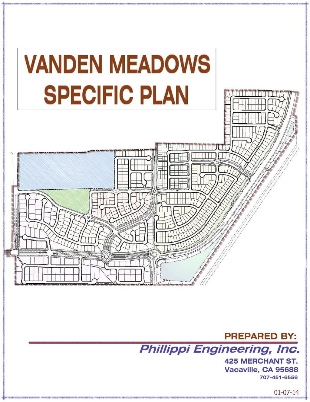
2 VANDEN MEADOWS SPECIFIC PLAN TABLE OF CONTENTS Page 1.0 INTRODUCTION SUMMARY Schools Foxboro Parkway Improvements to Leisure Town Road New Neighborhood Park Trail System Variety of Housing Types LEGAL CONTEXT Authority to Prepare Relationship to the General Plan Purpose and Intent Environmental Review Development Agreement How the Document is Organized PLANNING CONTEXT Regional Context Site Context Project Area Description Property Ownership VISION AND GOALS PROJECT VISION Objective and Programs Schools Foxboro Parkway Improvements to Leisure Town Road (Jepson Parkway) Neighborhood Park, Trails, Recreation and Connectivity Variety of Housing Types Civic and Public Benefits History Environmental and Sustainability 25 1
3 2.2 LAND USE CONCEPTS HOUSING GOALS OPEN SPACE GOALS OTHER GOALS LAND USE INTRODUCTION Planning Subareas LAND USE GOAL RESIDENTIAL ELEMENT GOALS Site Uses Density Standards Building Standards Parking Standards Other Development Standards Design Criteria COMMUNITY DESIGN Introduction Purpose and Intent Community Design Theme: Livable Neighborhoods Sound Walls Building Form Streetscape Character and Landscaping Entry Features Neighborhood School TRANSPORTATION AND CIRCULATION INTRODUCTION EXISTING SETTING Leisure Town Road Nut Tree Road Foxboro Parkway Vanden Road Major and Minor Collector Streets with Trail Residential Streets CONNECTIONS VEHICULAR STREET NETWORK NON-VEHICULAR CIRCULATION NETWORK 48 2
4 4.6 TRANSIT RECREATION, OPEN SPACE AND RESOURCE MANAGEMENT INTRODUCTION PUBLIC OPEN SPACE AND RECREATION PUBLIC FACILITIES INTRODUCTION WATER SUPPLY Potable Water Supply Non Potable Water Supply Abandon Existing Wells SEWER Abandon Existing Septic Tanks and Leach Fields STORM DRAINAGE Existing Setting Completion of Storm Drainage Improvements STORM WATER QUALITY Introduction FLOOD PLAINS Introduction NATURAL GAS, ELECTRICITY, TELEPHONE, AND CABLE TV Introduction COMMUNITY SERVICES AND FACILITIES FIRE PROTECTION POLICE PARKS AND RECREATION SCHOOLS SOLID WASTE IMPLEMENTATION ADMINISTRATION OF THE SPECIFIC PLAN Responsibilities for Administration of the Specific Plan DEVELOPMENT REVIEW Mitigation Monitoring Project Master Utility Plans Fair Share Cost Allocation PROCEDURE FOR ENVIRONMENTAL REVIEW PROJECT PHASING FOR INFRASTRUCTURE Roads 87 3
5 8.4.2 Potable Water Non Potable Water Sewer Storm Drain VANDEN MEADOWS PHASING MATRIX FOR DEVELOPMENT General Notes Fire Department General Notes Area A Area B Area C Area D Area E Area F Area G Area H Area H Area I Area I Area J Area K Area L Area M FUNDING MECHANISMS City Impact Fees School Impact Fees Park and Recreation Impact Fees Southeast Vanden Benefit District MAINTENANCE Public Safety District (CFD 11) Lighting and Landscape District Parks Maintenance District PROCEDURE FOR AMENDING THE SPECIFIC PLAN Screening of Proposed Amendments Administrative Amendments Major Amendments ADMINISTRATION OF THE DEVELOPMENT AGREEMENT 114 4
6 INDEX OF FIGURES Page 1.1 Regional Map Vicinity Map Vanden Meadows Properties Vanden Meadows Satellite Photo Vanden Meadows Conceptual Development Plan Proposed Land Use Proposed Zoning Vanden Meadows Southern Buffer Community Entry Features Locations Vehicular Circulation System Street Network Key Plan Section 1 - Leisure Town Road (Jepson Parkway) Section 2 - Nut Tree Road Section 3 - Foxboro Parkway Section 4A & 4B - Vanden Road Section 5 - Major Collector Street Section 6 - Minor Collector Street Section 7 - Residential Street Section 8 Residential Street with Separated Sidewalk Non-Vehicular Circulation Diagram Park and Trail Diagram Street Tree Concept Proposed Water Distribution System Proposed Non Potable Water Distribution System Sewer Collection System Plan Off-Site Sewer Improvements Storm Drain Master Plan Dry Utilities Master Plan Phasing Areas 97 INDEX OF TABLES 1.1 Parcels and Ownership Vanden Meadows Land Use Summary Vanden Meadows Residential Land Use Summary Exceptions to Maximum Coverage Exceptions to Building Standards 35 5
7 1.0 INTRODUCTION 1.1 SUMMARY The primary objective of this Specific Plan is to create development standards and a land use plan for the Vanden Meadows area that will satisfy the overall goals of the City while recognizing and tying into the Southtown Project and its design theme. The total Vanden Meadows area comprises 260 +/- acres and is bounded by Nut Tree Road on the west, the Southtown Project to the north, the railroad property to the east and the Vacaville/ Fairfield buffer to the south. (See Figure 1.1 Regional Map and Figure 1.2 Vicinity Map) The property comprises 5 land owners (See Figure 1.3 Vanden Meadows Properties). Presently the subject properties are vacant and are used mostly for dry farming (See Figure 1.4 Vanden Meadows Satellite Photo). The project is proposed to include the following amenities: Two new schools (Middle School and Elementary School) or one new K-8 of the Travis Unified School District. Complete the Foxboro Parkway Connection between Nut Tree Road and Leisure Town Road. Responsibilities, obligations and timing regarding construction of Foxboro Parkway are outlined in the two Development Agreements (The Estates at Vanden Meadows Project and The Villages at Vanden Meadows Project) entered into at the time of the preparation of this Specific Plan. Improvements to Leisure Town Road (in conformance with Jepson Parkway Plan). New Neighborhood Park (adjacent to the new school(s)). Trails throughout the development which also connect to the Southtown trail system. Variety of housing types and densities while maintaining an overall density of /- units/ acre, as specified in the 1990 General Plan (which designates a range of units/ acre for this area). 6
8 7
9 8
10 9

11 10
12 The following describes the prior mentioned amenities and outlines the benefits of annexation into the City of Vacaville: Schools The Travis Unified School District has acquired a /- acre site in the Vanden Meadows area and identified it as the future site of 1 or possibly 2 schools. The School District is currently conducting studies to determine if they will build a middle school and an elementary school or one K-8 school. The District master plan calls for this school to be built in 3-5 years (approximately ), but the date for constructing the school is dependent on rate of buildout of the Southtown Project and the Vanden Meadows Project. The school(s) will need City of Vacaville water and sewer services to develop the project which will require annexation into the City of Vacaville. We would note that the TUSD improved their frontage on Nut Tree Road as part of the widening work done for the Southtown development Foxboro Parkway The Foxboro Parkway connection from Nut Tree Road to Vanden Road has been identified by the City of Vacaville as a key arterial which will provide an enhanced connection to Leisure Town Road and Vanden Road (the future Jepson Parkway) from the Foxboro development area. Construction of the middle two lanes is a requirement of the Southtown Project. This will be required when Vanden Road is closed for construction of the new Community Park within Southtown. However, should development within Vanden Meadows occur prior to Southtown Phase 3, the Vanden Meadows developers will construct the Foxboro Parkway Connection. Furthermore, the center two lanes are listed on the City Improvement Project list with the potential for developers earning Traffic Impact Fee credits if they build the lanes Improvements to Leisure Town Road (Jepson Parkway) Recently the Solano Transportation Authority (STA) adopted the Jepson Parkway Plan Line a portion of which comprises Leisure Town Road and Vanden Road South of Leisure Town Road. With development of the Vanden Meadows area frontage roadway and landscaping improvements will be constructed along this key corridor serving Fairfield and Vacaville. Vanden 11
13 Meadows will be responsible for a portion of the landscaping and improvements adjacent to the developed properties New Neighborhood Park Development of the Vanden Meadows area will result in the construction of a new /- acre (gross, /- acres net) Neighborhood Park adjacent to the proposed school site Trail System In addition to the new park, a series of trails will be constructed throughout the development which will provide a pedestrian friendly connection with the park, the school(s) and with the Southtown Trail system. The Vanden Meadows project will be constructing approximately 4 miles of trails and when combined with the Southtown Trails represents a total of 10.6 miles of interconnected trails. These trails along with the park and landscaping comprise acres of dedicated open space and recreational area Variety of Housing Types The Vanden Meadows development includes a wide variety of housing types with an emphasis on moderate density development. The City of Vacaville General Plan policies require that new development in outlying areas construct a minimum of 25% moderate density housing to increase the City s existing moderate density which is currently at 20% +/-. The Vanden Meadows development proposes a total of 39.3 % +/- moderate density including a cluster/courtyard development and other small lot single family product. 1.2 LEGAL CONTEXT Authority to Prepare A Specific Plan is a planning and regulatory tool made available to local governments by the State of California. By law, Specific Plans are intended to implement a city or county s General Plan through the development of policies, programs and regulations that provide an intermediate level of detail between the General Plan and individual development projects. As a mechanism for the implementation of the goals and policies of a City s 12
14 General Plan, State law stipulates that Specific Plans can only be adopted or amended if they are consistent with the jurisdiction s adopted General Plan. It should be noted that as of the date of the preparation of this Specific Plan the City of Vacaville was in the process of Updating the General Plan. It is expected that either the Updated General Plan or this Specific Plan may need to be amended based on the compatibility of the two documents. The authority to prepare and adopt Specific Plans and the requirements for its content are set forth in the California Government Code through The law requires that a Specific Plan include text and diagrams that specify: The distribution, location, and extent of the uses of land, including open space, within the area covered by the plan. The proposed distribution, location, and extent and intensity of major components of public and private transportation, sewage, water, drainage, solid waste disposal, energy, and other essential facilities proposed to be located within the area covered by the plan and needed to support the land uses described in the plan. Standards and criteria by which development will proceed, and standards for the conservation, development, and utilization of natural resources, where applicable. A program of implementation measures including regulations, programs, public works projects, and financing measures necessary to carry out the items listed above Relationship to the 1990 General Plan The Vanden Meadows Specific Plan and the City s current 1990 General Plan provide a framework to guide future land use and development decisions within the 260 +/- acre planning area. The Specific Plan is consistent with, and functions as an implementation tool of the General Plan in three ways: A) By acting as a statement of planning policy that refines the general plan policies applicable to a specific plan area; B) By directly regulating land use and; 13
15 C) By bringing together detailed policies and regulations into a focused development program. The City s current General Plan Land Use Element, as updated, has two specific Implementing Policies (2.3-I 12 & 2.3-I 13) for the Vanden Meadows area. (The General Plan refers to this area as the South Vanden Area.) The Implementing Policies are italicized as follows along with how the Vanden Meadows Specific Plan addresses each statement highlighted with bold font: 2.3-I 12: In the portion of the Vanden Specific Plan area south of Foxboro Parkway and west of Vanden Road, the minimum lot size shall be 10,000 square feet. 1. As required by this policy, the minimum lot size south of Foxboro Parkway is designated 10,000 SF. 2.3-I 13: Require that the South Vanden Area, including the Southtown and Moody Project Areas, facilitate the development of a range of housing densities and opportunities, pedestrian and bicycle friendly design, neighborhood commercial sites, and recreational and neighborhood facilities, by including the following requirements: 1. A network of landscaped pedestrian/bike corridors that connect key elements of the area, such as the Regional Park and arterial streets. This is provided for in the Vanden Meadows Specific Plan. 2. New development adjacent to existing homes within the City limits shall match or exceed the size, character, and quality of adjacent homes and lots. This is provided for in the Vanden Meadows Specific Plan. Subarea G, the area designed for cluster/courtyard homes is adjacent to the Single Family Homes to be located in Southtown Phase 3. However, at the time of preparation of this Specific Plan Southtown Phase 3 had not been constructed. Locating quality detached single family courtyard homes adjacent to Southtown Phase 3 is considered compatible. The cluster lots also comply with Subsection 4 below. 14
16 3. All new residential development shall conform to the Residential Design Requirements for New Single Family Development. This is provided for in the Vanden Meadows Specific Plan. Said design requirements are attached and shall be part of the Vanden Meadows Specific Plan. 4. The Southtown project area will include a range of housing types and densities, attached, detached, and cluster housing. This is provided for in the Vanden Meadows Specific Plan. 5. Land shall be reserved for community uses such as private schools, membership organization, day care centers, and senior centers. Land has been reserved for 2 public schools a large neighborhood park and numerous trails. 6. A financing mechanism for all public facility improvements shall be established before development occurs. The Southtown Benefit District has been established for this area which ensures that each project will pay for its fair share of public facility improvements. 7. Nut Tree Road and Vanden Road shall be widened to the City standard width through the project sites for all projects that front on these streets. These street widenings will be done with the Vanden Meadows development. It should be noted that in response to concerns expressed by the Traffic Department, development of the Vanden Meadows area will result in a realignment of Vanden so that is does not intersect with the Foxboro Parkway/Leisure Town Road intersection. This realignment will significantly improve the Traffic Level of Service (LOS) at the Foxboro/Leisure Town Road/Vanden Road (south) intersection. 8. Leisure Town Road shall be widened and improved to the standards for the Jepson Parkway along the frontage of all projects that abut to Leisure Town Road. These street widenings will be done with the Vanden Meadows development and the Solano Transportation Authority s/city s Jepson Parkway project. 15
17 9. Foxboro Parkway shall be extended between Nut Tree Road and Vanden Road. The extension will be completed prior to the reconstruction and reconfiguration of Vanden Road. This is a requirement of the Southtown Phase 3 project. However, the Development Agreement requires that Foxboro Parkway be dedicated and constructed with Vanden Meadows should it develop prior to Southtown Phase Different development projects within the South Vanden Area shall coordinate their respective roads, bike paths/trails (See 1.1.5), landscape corridors and design standards to create a unified sense of place and identity. Roads, trails, landscape corridors are coordinated with the Southtown Project to provide continuity between the projects. 11. Commercial buildings shall be no more than an average of 30 feet in height, and be designed to front on the sidewalk, with parking at the rear of the property, when feasible, so as to enhance neighborhood aesthetics and to encourage pedestrian friendly design. No commercial buildings are anticipated in the Vanden Meadows area. 12. Infrastructure plans for sewer, water, storm drain, and traffic improvements shall be prepared prior to or in conjunction with the processing of subdivision maps for all development within the South Vanden areas, including the Southtown and Moody Project Areas. Plans for sewer, water, storm drainage and traffic improvements were created for the South Vanden Area as part of the Southtown Project which included development of the Vanden Meadows area. 13. Prior to the approval of any subdivision applications, the developers shall assure that all required domestic water supply and distribution systems, wastewater collection and treatment facilities, storm water management facilities, and roadway segment and intersection improvements will be incorporated into the final project plans. 16
18 The Vanden Meadows Project will incorporate the infrastructure as outlined in the master plans mentioned previously and the phasing matrix located in Chapter The lands to the south of the Southtown and the Moody Project Area will be subject to subsequent General Plan Amendments; Prezonings, and other prerequisites to annexation. As the Vanden Meadows Specific Plan proposals are in compliance with the policies in the City General Plan it is not anticipated that a General Plan Amendment will be required. Applications for development will include this Specific Plan, Prezoning, Pre-Tentative Maps, and Annexation Purpose and Intent The Specific Plan provides both general guidelines and specific standards for the development of Vanden Meadows and sets the parameters for a variety of land uses; thus the purpose of the Specific Plan is to provide a set of plans, policies, regulation and implementation programs for guiding and ensuring orderly, future development in accordance with the adopted Land Use Plan within the General Plan Environmental Review The adoption of a Specific Plan is a project under the California Environmental Quality Act (CEQA) and the CEQA Guidelines. To meet CEQA requirements, an EIR with Mitigation prepared by AES has been prepared as part of the process in adopting this Specific Plan. The EIR will provide the guidelines and requirements for future development phases. Each phase will be reviewed for consistency with the EIR analysis. If changes have been made to the project, the City would then need to determine the level of environmental review required depending on the changes requested Development Agreement As part of the project approval process, Development Agreements (DAs) will be entered into between project proponents and the City of Vacaville. The DAs will address such issues as the Community Benefit Contribution (CBC) 17
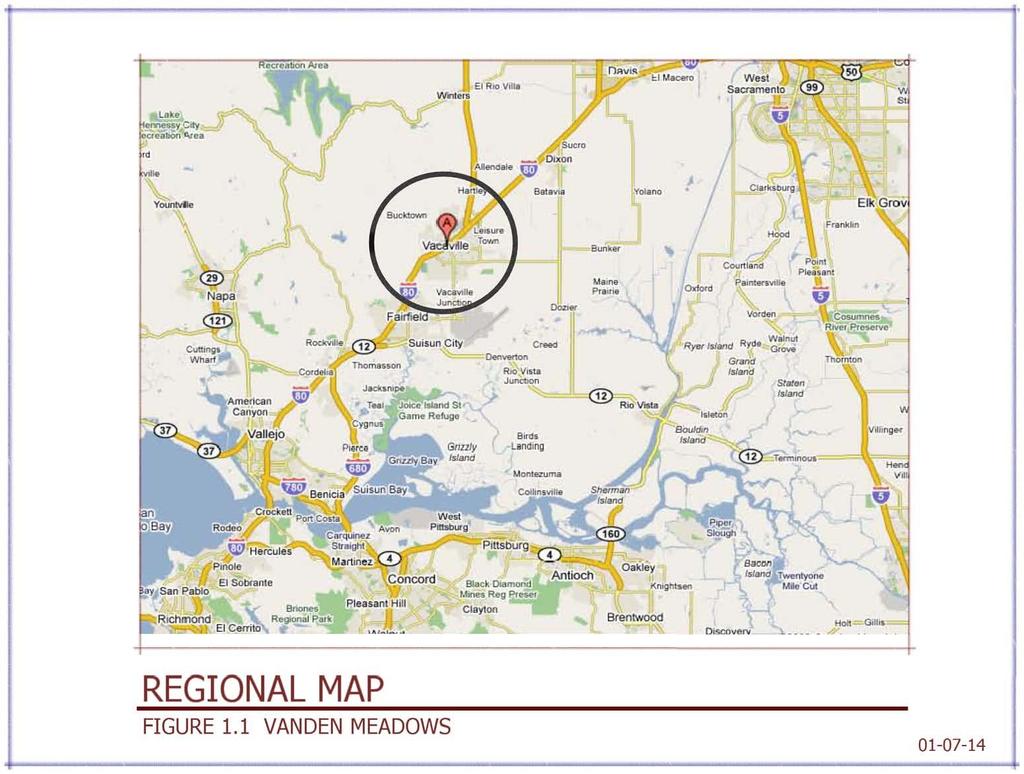
19 and the Planned Growth Ordinance (PGO); therefore, those issues will not be discussed within the Specific Plan How the Document is Organized The Specific Plan provides both the conceptual presentation of, and the specific framework for the development of Vanden Meadows. Chapter 1 summarizes the purpose of the document, legal authority, controlling regulations and the relationship to the Vacaville General Plan. Chapter 2 summaries the Project s Vision and the Land Use Goals of the Vanden Meadows Specific Plan. Chapter 3 summarizes the Land Uses, the Development Plan, the Standards to be applied throughout the Vanden Meadows area, Design Criteria and the Community Design. Chapter 4 provides detail regarding the Transportation and Circulation elements within the Vanden Meadows area. Chapter 5 details the Recreation and Open Space elements with the plan area. Chapter 6 provides details related to Public Infrastructure within the Vanden Meadows area. The chapter outlines needed facilities and timing for their construction. Chapter 7 details the Community Services and Facilities to be located in the plan area. Chapter 8 discusses Implementation of the Vanden Meadows Specific Plan and the procedures for amending the Specific Plan. The chapter also discusses the development review procedures and the allocation of project costs. The chapter details the Environmental Review required along with Project Phasing, Funding Mechanisms, and Maintenance. 1.3 PLANNING CONTEXT Regional Context The Specific Plan area is located in northern Solano County, in the southeastern corner of the City of Vacaville, as shown in the Vicinity Map in Figure 1.2. Vacaville is at the midpoint between San Francisco and Sacramento along Interstate 80, the major transportation link between these two growing urban areas as shown on the Regional Map Figure Site Context Project Area Description 18
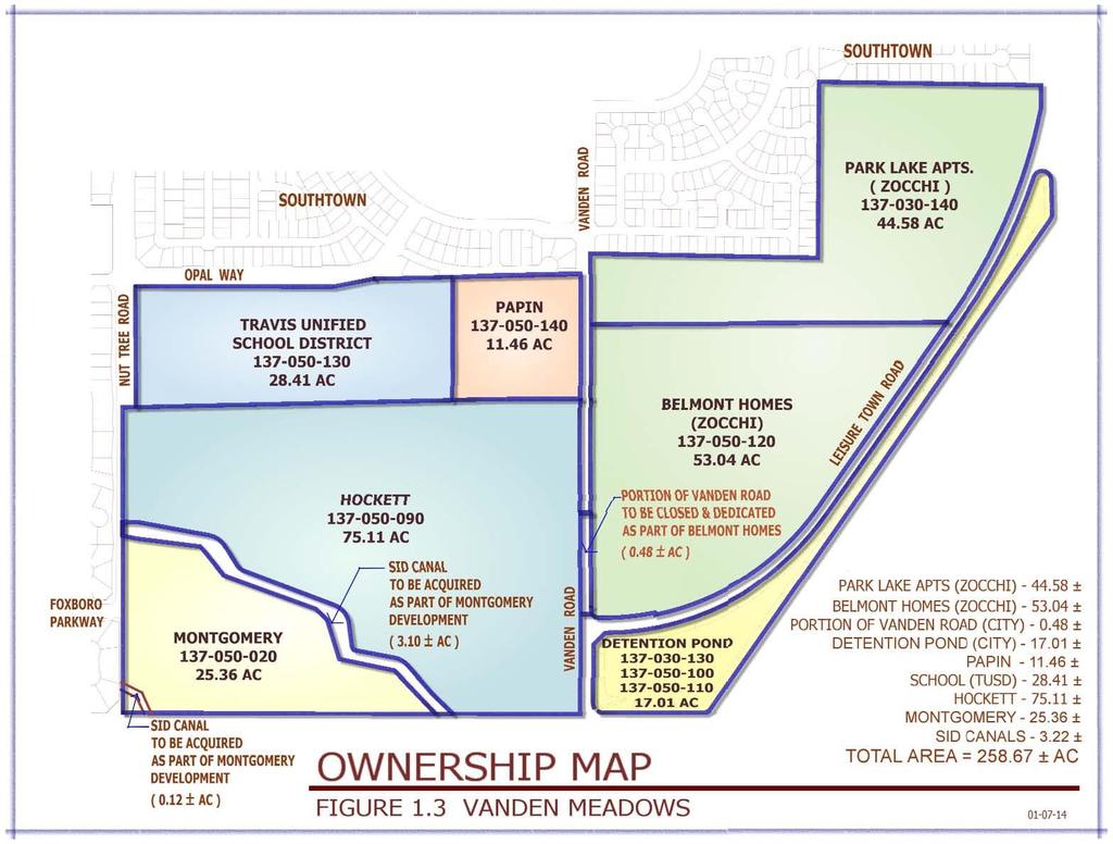
20 The Vanden Meadows area comprises 260 +/- acres and is bounded by Nut Tree Road on the west, the Southtown Project to the north, the railroad property to the east and the Vacaville/ Fairfield buffer to the south. (See Figure 1.2 Vicinity Map) The property comprises 5 land owners, (See Figure 1.3 Vanden Meadows Ownership Map). Presently, the subject properties are vacant and used mostly for dry farming (See Figure 1.4 Satellite Photo of the area) Property Ownership Property Owners within the Specific Plan Area (with Assessors Parcel Numbers (APN) and property acreage) are listed in Table 1.1. Table 1.1 Parcels and Ownership APN Owner Acres City of Vacaville (Detention Basin) Park Lane Apartments SID Canals Thomas Montgomery Roy Hockett City of Vacaville (Detention Basin) City of Vacaville (Detention Basin) Belmont Homes Travis Unified School District Evon Papin City of Vacaville (Vanden Road) 0.48 Total See Figure 1.3 for a graphical depiction of the parcels noted above. 19
21 2.0 VISION AND GOALS 2.1 PROJECT VISION The Vanden Meadows Project ties into the amenities developed within the Southtown Project. Southtown was developed with a central park as its focal point with trails and landscaping corridors radiating out from that central core. Vanden Meadows continues the theme of numerous trails and ties into the Southtown Trail system while also tying into the Vanden Meadows Park and school(s) (See Figure 2.1 Vanden Meadows Conceptual Development Plan). Vanden Meadows also provides for either a K-8 school or both an elementary school and a middle school campus. This school(s) is adjacent to a neighborhood park, creating a second major focal point in the Southtown/ Vanden Meadows area. Vanden Meadows provides for a diverse residential project with densities ranging from low density to medium density, with neighborhoods interconnected with landscaped trails adjacent to the interconnected roads. Policies and statements in the City of Vacaville 1990 General Plan indicate a strong desire to have more moderate density housing ( units/acre) in the outlying areas. To that end, within Vanden Meadows, 39.3 % +/- of the residential units are designated moderate density housing. This moderate density housing comprises a medium density cluster/courtyard style neighborhood and an area of low medium density small lot single family residential. These residential products fit within the moderate density category as specified in the 1990 General Plan. While focusing on providing a greater percentage of moderate density housing, the overall density still complies with the General Plan designation for this area. The proposed overall density is 3.8 +/- units per acre, which is in compliance with the designation for this area of Residential Low Density units per acre. 20

22 FIGURE 2.1 Vanden Meadows Conceptual Development Plan 21
23 2.1.1 Objective and Programs There are numerous Public Benefits that occur with the development of the Vanden Meadows area. These benefits are as follows: Schools The Travis Unified School District owns a /- acre site in the Vanden Meadows area and identified it as a site for 1 or possibly 2 schools. The type of school is determined through studies conducted by the Travis Unified School District to determine the need of an elementary school and a middle school, or a K-8 school. The School District master plan calls for this school to be built in approximately , depending on the rate of buildout of the Southtown Project and the Vanden Meadows Project. At the time that the Specific Plan was prepared information regarding the details and amenities of the school(s) was not available Foxboro Parkway The Foxboro Parkway connection from Nut Tree Road to Vanden Road has been identified by the City of Vacaville in the 1990 General Plan as a key arterial to provide an enhanced connection to Leisure Town Road and Vanden Road (the future Jepson Parkway) and to complete the Foxboro Parkway from the Foxboro development area. This connection ensures that the major movement of traffic from the Foxboro area to the east Leisure Town Road (Jepson Parkway) area will not impact interior residential neighborhoods. Construction of the middle two lanes is a requirement of the Southtown Phase 3 Project closes Vanden Road for construction of the Southtown Community Park. However, should Vanden Meadows develop before Southtown Phase 3; the Vanden Meadows developers may be responsible for the initial Foxboro Parkway connection. Timing of Foxboro Parkway will be determined through the Development Agreements. Completion of the Foxboro Parkway improvements (outside lanes, curb, gutter, sidewalk, landscaping and trails) is the responsibility of the property owners which abut the Parkway and is required when those properties develop. 22
24 Improvements to Leisure Town Road (Jepson Parkway) The Solano Transportation Authority (STA) adopted the Jepson Parkway Plan Line which comprises Leisure Town Road and Vanden Road South of Leisure Town Road. The City of Vacaville, in conjunction with STA, is responsible for construction and enhancement of the middle two lanes of Jepson Parkway. With development of the Vanden Meadows area, completion of the Jepson Parkway improvements (outside lanes, curb, gutter, sidewalk, landscaping and trails) is the responsibility of the property owners which abut the Parkway and is required to be completed when those properties develop. The developer is responsible for 20-feet of pavement, curb, gutter, sidewalk and landscaping on the development side of the roadway even if Jepson Parkway is built before the development Neighborhood Park, Trails, Recreation, and Connectivity The Vanden Meadows area includes a 7.49 acre (gross, 6.15 acres net) neighborhood park adjacent to the school site. This park size exceeds the City standard for neighborhood parks. It is required that there be 1.8 acres of neighborhood park per 1,000 residents which would result in only 5.0 acres of park. However, the Vanden Meadows project provides 7.49 acres of park which is an enhanced amenity when compared with other projects within the City of Vacaville that only meet the minimum standard. Provisions for timing, design and construction of the park are detailed in the Development Agreements. In addition to the new park, a series of trails will be constructed throughout the development which will provide a pedestrian friendly connection between the park, the school(s) and with the Southtown trail system. The Vanden Meadows project includes approximately 4 miles of trails and when combined with the Southtown trails, represents a total of 10.6 miles of interconnected trails. These trails along with the park and landscaping comprise acres of dedicated open space and recreational area. Each neighborhood within Vanden Meadows project is responsible for design and construction of the trails and backup landscaping within and adjacent to each 23
25 neighborhood. Maintenance of the trails is through an established Vanden Meadows Lighting and Landscaping Maintenance District (LLD). The Vanden Meadows trail system provides pedestrian and biking connectivity to the Southtown Park, Cannon Station Park, and the new Vanden Meadows Park Variety of Housing Types The Vanden Meadows development includes a variety of housing types with an emphasis on moderate density development. The City of Vacaville General Plan policies indicate that development in outlying areas construct a minimum of 25% moderate density housing to increase the City s existing moderate density housing inventory which is currently at 20% +/-. The Vanden Meadows development includes a total of 39.3 % +/- moderate density including a cluster development and other small lot single family product. Design features, architectural styles and other items that distinguish the neighborhoods are to be developed by the builders which construct each neighborhood. Design details are subject to the entitlement review processes for Design Review, subject to approval by the Vacaville Planning Commission. In addition, each builder is to design the entry features and fence treatments to be utilized in creating the distinctive neighborhoods. The entry feature locations are shown on Figure Civic and Public Benefits The Civic and public benefits have been enumerated in several other locations within this Specific Plan. Succinctly, the civic and public benefits include: increased educational opportunities with construction of a new school(s); increased recreational opportunities with installation of a new park; improved traffic circulation in Southeast Vacaville with construction of the Foxboro Parkway extension from Nut Tree Road to Leisure Town Road along with improvements to Leisure Town Road (Jepson Parkway), and; 24
26 additional biking and walking opportunities with the construction of numerous trails History There is little in the way of development history regarding this area. However, conceptual preparations for development of the Vanden Meadows area have been in the making since 2004, when an EIR was prepared for the Southtown Project. Also in 2004, the property was included in the near term annexation area (3-5 years) within the City of Vacaville Comprehensive Annexation Plan (CAP). In 2008 the City of Vacaville established the Southeast Vanden Benefit District which included the Specific Plan. The Benefit District established the fair share of costs attributable to Vanden Meadows for the infrastructure installed for the Southtown Project which was sized to accommodate the Vanden Meadows Development Environment and Sustainability The Vanden Meadows Development proposes a park and trail system which will enhance walking and biking opportunities for the residents of the area while also enhancing the open space feel and visual amenities. Additionally, some streets will have an enhanced streetscape with separated sidewalks and landscape strips (see Figure 4.2.9) at locations to be determined by the Developer and City staff which will add to the pedestrian safety and encourage increased use. 2.2 LAND USE CONCEPTS The land use concept for the 260 +/- acre Vanden Meadows development is a mix of residential uses complemented by the proximity to school(s), park and trails. The Vanden Meadows Specific Plan includes the following Land Use Goals: 1. Goal: Provide for a quality project through design of the homes, landscaping, streetscape, and public amenities. As each neighborhood is developed by individual builders, the builder will develop architectural themes and design features including landscaping, streetscape and public amenities. The 25
27 architectural themes and design features are subject to review and approval of the Planning Commission. 2. Goal: Include a variety of housing types, including an emphasis on moderate density housing (particularly small lot single family residential) that is in compliance with the goals and policies of the Vacaville General Plan. The overall density for Vanden Meadows has been established at 3.8 +/- units/ acre. This 3.8 +/- units/acre density is in compliance with the General Plan range designated for the area of units/ acre. 3. Goal: Provide a comprehensive system of trails, park and back up landscaping. The Vanden Meadows project includes 30 +/- acres of trails, park and back-up landscaping which interconnect throughout the development while also connecting with the Southtown amenities. 2.3 HOUSING GOALS Incorporated in the Vanden Meadows design are numerous design principles that foster community place-making, and therefore the Housing Goals of the Vanden Meadows Development are: 1. Goal: Create walkable neighborhoods with interconnected streets and trails that encourage pedestrian activity. As mentioned in Section 2.2 there are over 30 acres of trails, park and backup landscaping throughout the development. 2. Goal: Construct a neighborhood park which connects to the trails and is adjacent to the school(s). The Vanden Meadows Park addresses this goal. 3. Goal: Construct a neighborhood school(s) serving 2000 students. The school site owned by the Travis Unified School District addresses this goal. 4. Goal: Provide a variety of house plan types and exterior configurations with various options and styles. The developer of each neighborhood is responsible for developing the architectural theme for the house plans which addresses various options and styles. The design and construction of the homes will be 26
28 in compliance with the City s Residential Design Requirements for new Single Family Development. The architectural theme is subject to review and approval of the Planning Commission. 2.4 OPEN SPACE GOALS Goal: Plan a system of street and trail connections that link key elements (school(s), park, and trails) with the key elements of the Southtown Project (Community center/park, fire station, and trails). The street and trail system throughout the Vanden Meadows area connects with those like elements within the Southtown Project area. 2.5 OTHER GOALS The Vanden Meadows Specific Plan goals for land use and design, circulation, resource management, public utilities and services can be found in their respective chapters: Chapter 3 Land Use Chapter 4 Transportation and Circulation Chapter 5 Recreation, Open Space and Resource Management Chapter 6 Public Facilities Chapter 7 Community Services and Facilities 27
29 3.0 LAND USE 3.1 INTRODUCTION Vanden Meadows is a planned community that is designed to integrate residential opportunities, with school(s), park, trails, and the Southtown and Foxboro Community Facilities. The Vanden Meadows Specific Plan establishes a comprehensively planned community that is designed to work with the Southtown project to the north. The Land Use component of the Specific Plan is primarily residential with the non-residential uses comprising the school(s) and park Planning Subareas The Vanden Meadows area is divided into 13 Subareas (See Figures 3.1 and 3.2). Each subarea has a different land use designation. Table 3.1 details each of the subareas. The Estates at Vanden Meadows, the Tentative Map approved concurrently with this Specific Plan, comprises Subareas A, B, C, D, and E are owned by the Hockett group. This property is located between Nut Tree Road and Vanden Road with the Travis Unified School District (TUSD) property comprising a portion of its northern boundary and the Montgomery property, SID canal, and Fairfield-Vacaville buffer comprising its southern boundary. Subarea F is owned by Evon Papin and the property is bounded by Southtown to the north, the TUSD property to the west, Vanden Road to the east and the Hockett property to the south. At the time of preparation of this Specific Plan an application for a Tentative Map entitled Parkside had been submitted to the City for processing. The Villages at Vanden Meadows, another Tentative Map approved concurrently with this Specific Plan comprises Subareas G, H, and I are owned by Belmont Homes and Park Lane Apartments (collectively referred to as Zocchi Property) and are bounded by Southtown to the north, Vanden Road to the west and Leisure Town Road (Jepson Parkway) to the east and south. 28
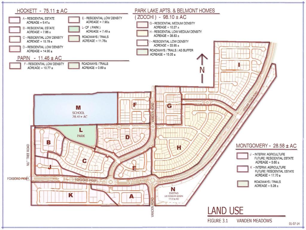
30 Subareas J and K are owned by the Montgomery group and are bounded by the Fairfield-Vacaville buffer to the south, Nut Tree Road to the west, and the Hockett property to the north and east. At the time of preparation of this Specific Plan an application for a Tentative Map entitled Foxboro Knolls had been submitted to the City for processing. Subarea L is designated as a future park and is currently owned by the Hockett group. Subarea M is owned by the Travis Unified School District and is designated for future school(s). Subarea N is designated as Detention Basin (Community Facility). Lastly, Subarea O is currently owned by various entities and is designated as trails, landscaping and agricultural buffer. 29
31 TABLE 3.1 VANDEN MEADOWS LAND USE SUMMARY (Refer to Figures 3.1 and 3.2 for Location of Areas) Sub Area Land Use Proposed Zoning Approximate Area (Acres) Residential Units A RE RE B RE RE C RLD RLD D RLD RLD E RHD RLD F RLD RLD G RMD RMD H RLMD RLMD I RLD RLD J RE RE K RE RE Density (Units/Acre) L CF CF 7.49 PARK M CF CF SCHOOL N CF CF O CF CF Non Residential Uses DETENTION BASIN TRAILS & LANDSCAPING** TOTAL * * - Total Land Use Density Excludes the School Property (28.41 Ac), the Ag Buffer (6.93 Ac), and the Detention Basin (17.01 Ac). ** - Includes Ag Buffer, not shown on Figure LAND USE GOAL Goal: To establish an attractive community that provides a variety of residential and recreational opportunities. The inclusion of 4 miles of trails, a park, and a school creates an attractive residential environment. Architectural building details, entry features and fence treatments are to be attractive and complementary to the trails and park elements. The Vacaville Planning Commission will review and approve architectural details, entry features and fence treatments to ensure that this goal of creating an attractive community is obtained. Housing variety is ensured with the variety of lot sizes as outlined in Section
32 31
33 32
34 3.3 RESIDENTIAL ELEMENT GOALS The Vanden Meadows Specific Plan Residential Element Goals are as follows: 1. Goal: Create a residential environment that complements and ties into the Southtown Project. The Vanden Meadows project street pattern and trail system tie into the Southtown Project street and trail system. The proposed school site abuts both the Southtown and Vanden Meadows Projects. 2. Goal: Encourage a range of housing types with an emphasis on single family moderate density development while addressing the policies and goals in the City of Vacaville General Plan. The policies in the Vacaville General Plan discuss the desire to increase the amount of moderate density housing within the City. Specifically those policies require that new outlying areas of the City have a minimum of 25% moderate density residential. Moderate Density, per the General plan, comprises the Land Uses of: Residential Low-Medium Density and Residential Medium Density. The proposed residential breakdown for the Vanden Meadows development is listed in Table 3.2. The land uses listed below are defined in the Current General Plan. TABLE VANDEN MEADOWS RESIDENTIAL LAND USE SUMMARY LOW DENSITY Land Use Approximate Area (Acres) 33 Residential Units Percentages RE % RLD % Total Percentages 60.72% MODERATE RLMD % DENSITY RMD % 39.28% HIGH DENSITY RHD % 0.00% TOTALS * % 100.0% *- Acreage excludes public facilities, detention basin, school(s), and agricultural buffer. 3. Goal: Ensure that each neighborhood has direct access to the interconnected trail system. Review of the Site Plan for the Vanden Meadows development clearly shows street and trail connections to Nut Tree Road, Foxboro Parkway,
35 Vanden Road, and Leisure Town Road. The Vanden Meadows street and trail system provides access to the Vanden Meadows Park and the school Site Uses Vanden Meadows is a residential development and as such, the Permitted Uses, Conditional Uses, and Prohibited Uses will be identical to those listed in the City of Vacaville Land Use and Development code (latest edition) for the various residential zone districts Density Standards Density ranges for the various residential zone districts shall comply with the City of Vacaville Land Use and Development Code with the exception of the land use Residential Estates, which may have a minimum density of 2.5 units per acre. Lot Coverage (building area divided by lot area) shall comply with the City of Vacaville Land Use and Development Code except as noted in Table 3.3. The exceptions to maximum coverage in Table 3.3 are to encourage the use of 1-story homes. Too often, developers are restricted to 2-story homes because the Lot Coverage strict guidelines provide no opportunities for creativity. A one-story house meeting all setback standards in the Land Use and Development code along with the exceptions noted in Table 3.4 can result in a Lot Coverage of close to 50%, hence the exceptions listed in Table 3.3. TABLE 3.3 EXCEPTIONS TO MAXIMUM COVERAGE Zoning District Density Maximum Lot Coverage for singlestory only RLD RLMD RMD
36 3.3.3 Building Standards The standards for building height and front, rear and side yard setbacks shall comply with the City of Vacaville Land Use and Development Code except as noted in Table 3.4. TABLE 3.4 EXCEPTIONS TO BUILDING STANDARDS Zoning District Density Minimum Front Yard to Habitable Space* Minimum Side Yard** Minimum Rear Yard Minimum Distance Between Structures RLD & 10 *** RLMD & RMD & * - On corner lots, the minimum front setback from the angled corner shall be 10 and from the front of the garage the setback shall be 20. **- On corner lots, the minimum side yard setback shall be the larger option. For two story homes, an additional 5 setback on one side is required. ***- Footnote 5 of the Land Use and Development Code does not apply Parking Standards Parking shall be provided in accordance with City of Vacaville Land Use and Development Code, Chapter Other Development Standards For Development Standards not specifically mentioned in this Specific Plan, refer to Chapter Zoning in the City of Vacaville Land Use and Development Code and the City s Residential Design Requirements for New Single Family Development Design Criteria Individual dwelling units shall be designed at time of development by the builder and is subject to review and approval by the Planning Commission. It is intended that each neighborhood have a distinct architectural theme. The theme should be incorporated throughout the neighborhood including but not limited to housing architectural elements, entrance monuments, and landscaping. 35
37 3.4 COMMUNITY DESIGN Introduction Goal: Create and ensure a successful walkable community which interconnects with the Southtown project to the north Purpose and Intent 3.4-P-1 Create an attractive residential setting that compliments surrounding residential development to the north and west and the agricultural uses to the east and south. The Design Review process for the design of the homes will ensure compliance with this. 3.4-P-2 Create a suitable buffer between the Vanden Meadows development and the agricultural uses to the south and east. The Vanden Meadows layout creates a large landscaped area along Leisure Town Road which creates a 500-foot buffer between the residential development and agricultural lands to the east, consistent with the 1990 General Plan. Along the southern boundary the houses will face south and there will be an 80-foot buffer between the houses and the agricultural lands to the south. This southern buffer will include landscaping and a small masonry wall with wrought fencing on top. See Figure P-3 Provide design guidelines to ensure that Vanden Meadows is an attractive setting for Vacaville residents. This Specific Plan provides guidelines, but the Design Review process will ensure compliance with this Community Design Theme: Livable Neighborhoods The intent of the Vanden Meadows development is to create neighborhoods that families can afford while being aesthetically pleasing and friendly. To that end the development encourages a variety of housing types including small single family homes on small lots. 3.4-P-4 House design and materials are intended to be of high quality while recognizing the need to keep homes affordable. The 36
38 choice of materials, colors and architectural detailing shall be thoughtfully integrated into the design. Builders shall develop house plans which incorporate this policy. The house plans and architectural elements will subject to the review and approval of the Planning Commission. 3.4-P-5 Neighborhoods should be created with similar design themes and elements to create strong neighborhood identities. Builders, while working with the Planning Department, shall develop architectural elements that create strong neighborhood identities, subject to the review and approval of the Planning Commission Sound Walls Sound walls shall be constructed where residential development interfaces with community arterials, collectors and at locations listed hereafter. a) The Estates Foxboro Parkway, Proposed Jepson Parkway, Vanden Road Realignment and Street A. Sound walls shall also be constructed along Street A on the North side (between Vanden Road and Street I0 and along the South side (between Vanden Road and Street J) with the final limits of the wall being determined at the time improvement plans are submitted. b) Villages Leisure Town Road, Vanden Road, Street P (between Leisure Town Road and Street R) and Street Z (between Leisure Town Road and Street Y). Walls shall conform to the following requirements: a) Walls shall be 6 foot high or higher if required by EIR Mitigation Measures, capped, and with texture as approved by the Community Development Director. b) Pilaster columns shall be utilized at corners, entries and transitions. c) Walls may be curved or notched back to create visual interest. d) The top of the wall shall be kept level. When conforming to grades, the wall shall be stepped. 37
39 38
40 39
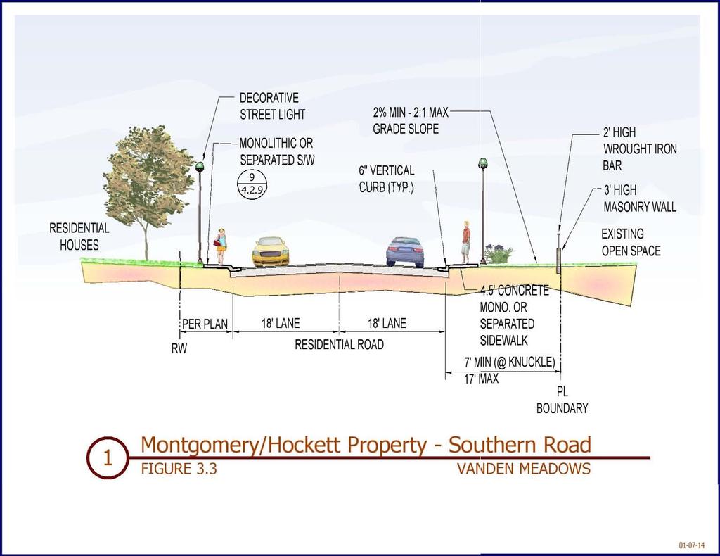
41 3.4.5 Building Form The houses shall be designed to create a sense of community while providing variety. This can be accomplished by utilizing multiple varied and distinctive architectural designs, themes, and elements. In general the community s architecture should create a pedestrian friendly street experience through appropriate scaling, create neighborhood identity through continuity within the separate neighborhoods, and recognize the need for more affordable living. 3.4-P-6 There shall be a wide range of product types incorporated into the various neighborhoods. 3.4-P-7 Garage doors shall not become the dominant element of the front elevation. Relief should be achieved by recessing doors and by varying the garage orientation (recessed, swing-in, side street access, etc.) Streetscape Character and Landscaping Streets will be planted with approved street trees and enhanced streetscape landscaping as defined in the final landscape plans of subsequent submittals. Streetscapes should reflect the identity of the roadway system and incorporate separated sidewalks with parkway strips (as outlined below or on as approved on a case by case basis by City Staff) when homes front on the streets. Taller more imposing trees and widened (20-35 ) landscape strips should define the arterials and major collectors. Medium-sized trees and smaller (5-20 ) landscape strips should articulate the minor collectors. In general street trees should be used consistently on residential streets to establish attractive neighborhoods. Parkway strips shall be used on the following streets as identified on the Tentative Maps: Subareas B & C Streets C, E, F, G; and all the Courts (A-D). Subarea H Streets S and T. Subarea I Streets Y, Z, XX and YY. 40
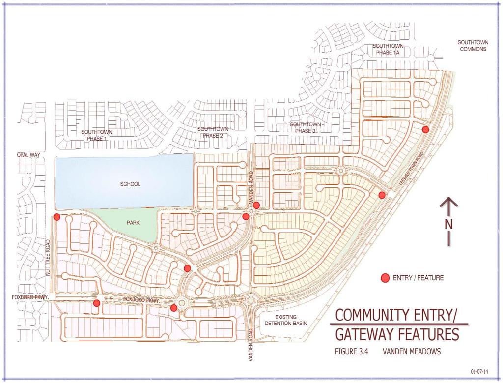
42 Throughout Subareas A, J, and K. The following are trees that may be planted in the parkway strips: Botanical Name Common Name Deciduous Trees Acer buergerianum Trident Maple Cercis Redbud Chilopsis linearis Desert Willow Lagerstroemia Crape Myrtle Prunus Flowering Plum Evergreen Trees Arbutus unedo Strawberry tree Geijera parviflora Australian Willow Laurus nobilis Saratoga Sweet Bay Ligustrum Privet Rhaphiolepis Majestic Beauty Rosacea Rhus lancea African Sumac Entry Features Entry features should be located at eight key locations on the exterior of the Vanden Meadows development area (in each case the developer closest to the designated feature will be responsible for its construction). Refer to Figure 3.4 Community Entry Features Locations: 1. At the intersection where Leisure Town Road meets the northern most street (Street Z ). 2. At the intersection where Leisure Town Road meets the main street into the Vanden Meadows project (Street P ). 3. At the intersection of the second street from the north (Street H ) just off the west side of Vanden Road. 4. At the intersection of the northern most street (Street H ) just off the east side of Vanden Road. 5. At the intersection where Nut Tree Road meets the northern most street (Street A ). 41
43 6. At the intersection where Vanden Road meets the southernmost street (Street A ). 7. On the south side of the intersection where Foxboro Parkway meets Vanden Road. 8. At the intersection where Foxboro Parkway meets the westernmost residential street. 3.4-P-8 The developers of the Vanden Meadows project will design and install entry features at the locations designated above. The design will include high quality elements that comply with the City of Vacaville Gateway ordinance. The design for the first entry feature will be used for subsequent features Neighborhood School The Travis Unified School District has acquired a /- acre site in the Vanden Meadows area and has identified it as the future site of 1 or possibly 2 schools. The District is conducting studies to determine if they will build a middle school and an elementary school or one K-8 school. The District Master Plan calls for this school(s) to be built in 3-5 years depending on the rate of buildout of the Southtown Project and the Vanden Meadows Project. The schools(s) will need City of Vacaville water and sewer services to develop the project which will require annexation into the City of Vacaville. The existing Opal Way has been designed and constructed with the expectation that it would serve as an access for one of the school sites. Further, the City of Vacaville is planning to install a traffic signal at the intersection of Opal Way and Nut Tree Road to provide traffic control once the school is in operation. The Travis Unified School District, with input from the City of Vacaville and the developers of the Vanden Meadows project, will design and construct a school that is in keeping with the character of the Vanden Meadows development area to serve the needs of the residents of the Southeast Vanden area. It should be noted however, that the State of California is the final authority on the design of the school. 42
44 4.0 TRANSPORTATION AND CIRCULATION 4.1 INTRODUCTION Goal: Provide a circulation system which maintains and improves access and connectivity between and within Vanden Meadows and Southtown and is consistent with the 1990 General Plan. The Vanden Meadows project street and trail system has been designed to create continuity between Southtown and Vanden Meadows. The realigned Vanden Road improves the traffic level of service at the intersection of Foxboro/Jepson Parkway (Leisure Town Road) by eliminating one leg of the proposed 4 leg intersection. The realigned Vanden Road also serves to slow traffic through Vanden Meadows and discourages cut through traffic from Nut Tree Road through the Southtown Project. The connection of Foxboro Parkway between Nut Tree Road and Jepson Parkway completes the east-west arterial connecting Peabody Road through Nut Tree Road to Jepson Parkway, consistent with the 1990 General Plan. Traffic from Nut Tree Road and areas east of Nut Tree Road will be encouraged to use Foxboro Parkway to access Jepson Parkway (Vanden Road and Leisure Town Road) because of the more direct routing. Because the internal street circulation system has been designed to discourage cut through traffic going through residential areas, the through traffic is anticipated to utilize Jepson Parkway and Nut Tree Road for travel going north and south in the area and utilize Foxboro Parkway for travel going east and west. The Trail system within the Vanden Meadows Project has been designed to provide direct connections to the school and park sites within the Vanden Meadows and well as a direct connection to the Southtown Park via the trails adjacent to Vanden Road. 43
45 4.2 EXISTING SETTING Vanden Meadows is bounded by Leisure Town Road on the east, Nut Tree Road on the west, the Southtown Development to the north and the Vacaville-Fairfield buffer to the south. The existing roadways and the proposed vehicular circulation system through the Specific Plan area are shown on Figures 4.1 and 4.2. It should be noted that the intersections of Foxboro/Realigned Vanden and Foxboro/Vanden/Jepson Parkway are shown in various figures throughout the Specific Plan as intersections controlled with roundabouts; however, the method of intersection control will be determined by the Director of Public Works. The major streets within the Vanden Meadows area are described as follows: Leisure Town Road (future Jepson Parkway) Currently Leisure Town Road is a two lane rural road bordering the eastern portion of the area. Future plans call for this road to be redesignated as Jepson Parkway and will be a four lane arterial with large landscaped frontages. The developers of Vanden Meadows will be responsible for construction of the fronting curb, gutter, sidewalk, 20 feet of pavement and the landscaping per the Jepson Parkway plan line as recently approved by the Solano Transportation Authority (STA). See Figure 4.2 for the location and Figure Leisure Town Road (Jepson Parkway) for the details of the proposed street section. The City is currently in the design phase of Jepson Parkway Improvements from the south City Limits through Elmira Road. Final design and right of way for Jepson Parkway adjacent to Vanden Meadows shall be incorporated into Vanden Meadows Final Map(s) and improvement plans Nut Tree Road Nut Tree Road borders the Vanden Meadows development on the west. Currently the road is two lanes but is designated to be a four lane arterial with buildout of the area. The western portion of Nut Tree Road was completed with the Foxboro development and the developers of the Vanden Meadows area will be responsible for completing the required final improvements (including the landscaping and trails) to Nut Tree Road. See 44
46 Figure 4.2 for the location and Figure Nut Tree Road for the details of the proposed street section Foxboro Parkway Foxboro Parkway is identified in the General Plan as a Major Arterial within the Southeast Vanden Area and within the Foxboro development area. Currently, Foxboro Parkway exists east of Nut Tree Road and ultimately will connect with Jepson Parkway. This connection will greatly improve circulation in the southeast Vanden area by providing a more direct connection to Vanden Road South/Jepson Parkway which will improve access to Travis Air Force Base to the south. This direct connection from the Foxboro development area to Jepson Parkway will also improve access to Interstate 80 to the north by allowing traffic to access the major north- south arterial more easily. The City of Vacaville recently added the middle two lanes of the proposed Foxboro Parkway to the Traffic Impact Fee (TIF) program. Responsibilities, obligations and timing regarding construction of Foxboro Parkway are outlined in the two Development Agreements (The Estates at Vanden Meadows Project and The Villages at Vanden Meadows Project) entered into at the time of the preparation of this Specific Plan Vanden Road Currently Vanden Road is a two lane rural road which will be improved to collector standards with a landscaped median for that portion of the road north of Leisure Town Road. In order to improve traffic flow for the future Jepson Parkway, Vanden Road will be realigned to intersect Foxboro Parkway west of the Foxboro/Leisure Town Road (Jepson Parkway) intersection. This portion of the Vanden Road, including landscaping and trails, will be completed with development of Vanden Meadows. Vanden Road south of Leisure Town Road will be designated Jepson Parkway and the Vanden Meadows development will be responsible for completing the frontage improvements (curb, gutter, sidewalk, some pavement and landscaping). The balance of improvements will be completed by the City of Vacaville (through a Solano Transportation Authority (STA0 grant) or by the fronting property owner if the work is not completed when development south of Foxboro Parkway begins. If the fronting property owner improves Jepson Parkway (Vanden Road South of Foxboro) the developer will be entitled to 45
47 TIF credits for installation of the middle two lanes. See Figure 4.2 for the location and Figure Vanden Road for the details of the proposed street section Major and Minor Collector Streets with Trail Within the Vanden Meadows development there are two street sections that are designated Major Collector Streets and two street sections that are designated Minor Collector Streets. Major Collector Streets are collectors (40 feet wide) with trails on both sides of the street and with no residential units fronting on the street. See Figure 4.2 for the location and Figure Major Collector Street for the details of the proposed street section. Minor Collector Streets are collectors (40 feet wide) with trails on one side of the street and some residential units fronting on the street. See Figure 4.2 for the location and Figure Minor Collector Streets for details of the proposed street section Residential Streets All other streets not mentioned above will be designated as residential streets. These streets will comply with the City of Vacaville standards for residential streets. See Figure 4.2 for the location and Figure Residential Street for details of the proposed street section. Consideration for City approved traffic calming measures shall be on straight streets. See also Figure Residential Streets with Separated Sidewalks as detailed in Section Streetscape Character. 4.3 CONNECTIONS Completion of the street network within the Vanden Meadows area will provide a significant improvement in vehicular circulation throughout the southeast portion of Vacaville. The Foxboro Parkway connection will provide ease of movement from Southeast Vacaville to Travis Air Force Base and to Interstate 80. In addition, this connection will provide for a direct connection to Peabody Road from the southeast Vacaville area. 46
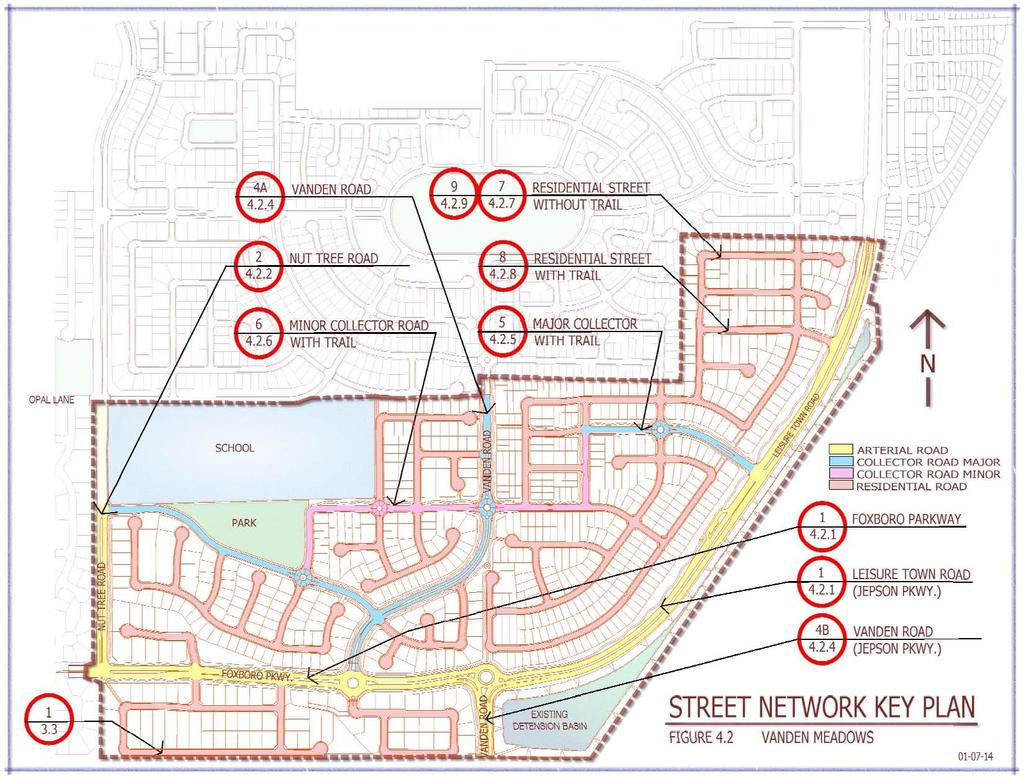
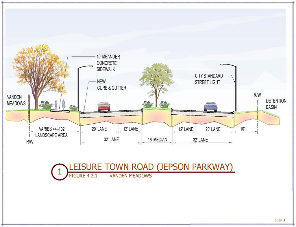
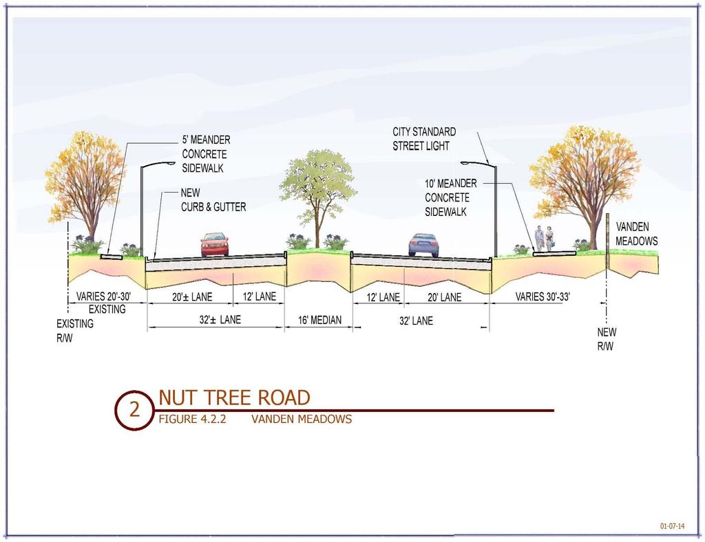
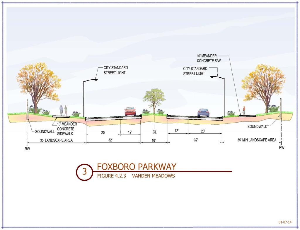
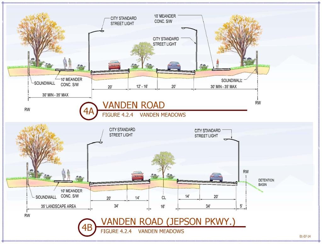
48 The completion of Jepson Parkway as envisioned by the STA will provide enhanced connections between Suisun City, Fairfield, Vacaville and Dixon. 4.4 VEHICULAR STREET NETWORK The following are implementing policies to ensure completion of the Vehicular Street Network as envisioned by this Specific Plan. The Traffic Mitigation Monitoring Plan outlined in the EIR is attached as Attachment X and incorporated by reference. 4.4-P-1 The density of the residential development shall not generate traffic volumes that exceed the capacity (LOS C) of the Foxboro Parkway, Vanden Road, and Jepson Parkway Intersections. The acceptable LOS designation may be modified by the Updated General Plan or Council action. 4.4-P-2 The LOS throughout the remainder of the Vanden Meadows area shall comply with the City s Traffic Mitigation Policy at the time of approval of improvement plans. 4.4-P-3 The City will require the Master Developer to enter into a Development Agreement to provide the necessary roadway improvements to serve the development and mitigate related traffic impacts. 4.4-P-4 Specific Plan developers shall fund circulation improvements necessitated by the Specific Plan development through various funding mechanisms (i.e. assessment districts, traffic impact fees, private funding, etc.). 4.4-P-5 The public road rights-of-way and street improvements shall comply with City of Vacaville standards and said rights-of-way will be dedicated to the City of Vacaville as public streets as shown in the following Figures, or as a result from an Update of the General Plan: Section 1 - Leisure Town Road (Jepson Parkway) Section 2 - Nut Tree Road 47
49 4.2.3 Section 3 - Foxboro Parkway Section 4A & 4B - Vanden Road Section 5 - Major Collector Street Section 6 - Minor Collector Street Section 7 - Residential Street Section 8 Residential Street with Trail Section 9 Residential Street with Separated Sidewalk 4.4-P-6 Focused traffic analysis shall be provided to determine traffic controls at arterial and collector intersections. 4.4-P-7 Phasing of the Project roadway network shall not result in potential for creating cut through traffic on Project roadways or roadways near the Project. 4.5 NON-VEHICULAR CIRCULATION NETWORK Goal: Develop a comprehensive bikeway/ pedestrian system that connect the park, school(s), and Southtown development, and promote the use of alternatives to driving. 4.5-P-1 Construct the trail/bike system as shown in Figure 4.3 Non-Vehicular Circulation Diagram. Construction shall include signings, markings and improvements determined by the Public Works Director to provide for pedestrian and bicycle safety, particularly at intersections. 4.5-P-2 Construct a vehicular parking facility on Leisure Town Road to allow for those outside the Vanden Meadows area to utilize the trail/bike system. 4.5-P-3 The design of trail locations shall incorporate standards for emergency services visibility and access, safety lighting if appropriate, and planning for fire protection. 48
50 4.6 TRANSIT Goal: Promote increased local transit ridership and provide Specific Plan area residents with the opportunity to use public transportation as an alternative to driving. A decision on providing local transit within new developments is guided by short range and long range transit plans. Transit service in Vacaville is provided by Vacaville City Coach through a fixed route and dial-a-ride services. City Coach services are coordinated with other area transit services for weekday peak hour commute service along Interstates 80 and 680 corridors. This includes services from the Fairfield/Suisun Transit and Vallejo Transit systems with routes that connect to BART stations in Pleasant Hill and El Cerrito. The following are implementing policies to meet the stated goal: 4.6-P-1 Currently, Route 8 travels through the Foxboro area along Youngsdale Drive to Nut Tree Road and then heads north. As the City updates short and long range transit plans providing transit service to the Vanden Meadows area will be considered as it is for all areas of the City. 4.6-P-2 If the City determines that transit service would be extended into Vanden Meadows area by expanding Route 8 (or any other route) into Vanden Meadows, the developers of Vanden Meadows shall install bus turnouts and transit stops in location(s) designated by the City. The Developer may be required to provide transit turnouts on arterials and collectors to provide access to transit within a ¼ to ½ half mile of potential riders. Transit turnouts shall include provision of a bus shelter within public right of way. The Public Works Director, based on recommendation of the Public Works Transit Manager, may require provision of bus turnouts and bus shelter pad and shelter improvements at locations on arterials and collectors being constructed by the Project. 49
51 4.6-P-3 If City determines that potential extension of transit into the Vanden Meadows area is long term, developers shall provide right of way for bus turnouts and shelters on arterials and collectors to provide access to transit within a ¼ to ½ half mile of potential riders. City may require in-lieu fees for the provision of transit turn outs and bus shelters in the future. 50
52 51
53 52
54 53
55 54
56 55
57 56
58 57
59 58
60 59
61 60
62 61
63 62
64 5.0 RECREATION, OPEN SPACE AND RESOURCE MANAGEMENT 5.1 INTRODUCTION 1. Goal: To protect and enhance existing biological resources. Currently a biological assessment is underway which will ascertain the existing biological resources, if any. Specific mitigation measures will be proposed if any endangered species or wetland features are impacted by the Vanden Meadows development. 2. Goal: To provide a development that is compatible with the Agricultural uses to the east. The Vanden Meadows Specific Plan calls for a 500 foot buffer between the proposed residential and the existing agricultural uses east of the railroad track. This 500 foot buffer results in a large landscaped area on the west side of Leisure Town Road. With this buffer in place agricultural uses will not be impacted by the proposed project. 5.1-P-1 The area within the 500 foot buffer, west of the existing Leisure Town Road right of way, will be dedicated to the City of Vacaville as backup landscaping for Leisure Town Road with maintenance paid for by the residents of Vanden Meadows through the use of a Lighting and Landscape District (LLD). 5.2 PUBLIC OPEN SPACE AND RECREATION 3. Goal: To provide recreational activities by providing for a public park and bike/pedestrian trails that connect with the park and the Southtown Development to the north. As mentioned in Section 2; development of the Vanden Meadows area will result in the construction of a new 7.49 acre park adjacent to the proposed school site. The Travis Unified School District has indicated that they would like to have a joint use agreement between the District and the City regarding this park to increase its usability and functionality. That joint use 63
65 agreement would be negotiated sometime in the future between the Travis Unified School District and the City of Vacaville. In addition to the new park, a series of trails will be constructed throughout the development which will connect with the park, the school(s) and with the Southtown trail system. The Vanden Meadows project will be constructing approximately 4 miles of trails and when combined with the Southtown trails represent a total of 10.6 miles of interconnected bike/pedestrian trails. Within the Vanden Meadows area, these trails along with the park and landscaping comprise acres of dedicated open space and recreational area P-1 Park, trails, and backup landscaping will be designed to enhance the Vanden Meadows development area using drought tolerate plants in conformance with the City of Vacaville landscape ordinance. The park, trails and back-up landscaping will be dedicated to the City of Vacaville as public amenities with maintenance paid for by the residents of Vanden Meadows through the use of a LLD. Park construction may be eligible for park fee credits subject to a Park Fee Agreement to be negotiated between the Master Developer and the City of Vacaville. Trails and back-up landscaping shall not be subject to fee credits. 64
66 65
67 66
68 6.0 PUBLIC FACILITIES 6.1 INTRODUCTION This section of the Specific Plan provides both general and specific guidelines for the development of future infrastructure facilities necessary to serve the Vanden Meadows development area. The infrastructure facilities covered in this section include water distribution (potable and non-potable), sanitary sewer collection, storm drainage and detention, gas, electric, telephone, and cable TV. This section s specific purpose is to: 1. Ensure that the project incorporates adequate water and sewer facilities to meet the needs of the Vanden Meadows area. 2. Use non-potable water in Vanden Meadows to reduce demand for potable water. 3. Utilize the Southtown detention basin to mitigate for increased runoff due to development. 4. Present preliminary sizes of utility components. Final pipe sizes will be based on computer modeling using the City wide models maintained by the Utilities Department and funded by the developers and will be subject to the approval by the Director of Utilities prior to design approval. On-site piping and utility facilities shall be sized to accommodate only the development in the Specific Plan area. 5. Identify off-site improvements which are necessary to serve the project. Goal: Ensure that project design incorporates adequate infrastructure facilities to meet City design standards. Goal: To the extent required by law, use non-potable water and water conservation practices in the Vanden Meadows area to reduce demand for potable water. 6.2 WATER SUPPLY Goal: Provide an adequate and reliable source of potable and non potable water for the Vanden Meadows Specific Plan area. 67
69 6.2.1 Potable Water Supply Figure shows the Proposed Water Distribution System with existing and proposed water line sizes. In general, Leisure Town Road will have an 18 water transmission main with 12 water mains in all arterials and collectors. In addition, 12 water mains will be adjacent to and through higher density areas to ensure adequate fire flow. All other streets will contain an 8 or 12 water line with domestic services and fire hydrants as required serving the development. It should be noted that in order to serve the water demands of the Specific Plan area, the expansion of the City s water system will be required. This expansion will be accomplished through payment of Water Impact Fees and the installation of water facilities as outlined in this Specific Plan. 6.2-P-1 Each developer will be responsible for construction of their portion of the water lines shown on the Proposed Water Distribution System. Each developer will be required to demonstrate that the proposed phasing of each water line installation, including buildout will provide for adequate redundancy (looping) and flow to the satisfaction of the Director of Utilities. 6.2-P-2 Developers will comply with the City of Vacaville water conservation ordinance (such as low-flow shower heads and toilets) in the construction of the homes. 6.2-P-3 Developers will use low-flow irrigation systems and drought resistant plant materials to the reasonable extent feasible. DIF 88 The 18 water transmission main in Leisure Town Road has been identified as a capitol improvement project (DIF 88) within the City of Vacaville Development Impact Fee Ordinance and is subject to partial reimbursement to the developer who installs any portion of this line as outlined within said ordinance Non Potable Water Supply 68
70 Figure shows the Proposed Non Potable Water Distribution System Plan with existing and proposed water line sizes. In general, 8 water mains are to be located in all arterials and within Vanden Road creating a nonpotable looped system with the South Vanden non-potable system. 6-8 lines are to be located internally as necessary to serve their respective developments. Final design shall conform to SID Specifications and City Master Planning. The City shall work with the master developer and SID to ensure that the non-potable system complies with the 1995 Master Water Agreement between the City and SID Abandon Existing Wells Any existing wells on the property shall be abandoned per the Solano County Health Code. 69
71 70
72 71
73 6.3 SEWER Goal: Provide an adequate and reliable wastewater collection system for the Vanden Meadows Specific Plan area. Figure shows the Sewer Master Plan with existing and proposed line sizes. In general, all streets will have a minimum of an 8 line. Within a small number of streets, 10 and 12 lines are shown. 6.2-P-1 Each developer will be responsible for construction of their portion of the sewer lines shown on the Sewer Master Plan. Each developer will be required to demonstrate that the proposed phasing of each sewer line installation, including full buildout, will provide for adequate collection and conveyance of wastewater to the satisfaction of the Director of Public Works. In addition to the on-site sewer improvements which will be required to service the Vanden Meadows development, three off-site sewer improvements were identified in the report prepared by West Yost Associates titled: Southtown Area Sewer Plan Evaluation and CSPS Trunk Sewer Service Area Master Plan of July 29, All sewer improvements are to be consistent with the Southtown Area Sewer Plan Evaluation and the CSPS Trunk Sewer Service Area Master Plan. These improvements and the timing for when the improvements are required are described as follows (See Figure Off-Site Sewer Improvements for details): Phase 1: Triggered by issuance of the 770 th building permit within the Southeast Vanden area (which includes both Southtown and Vanden Meadows). This phase requires the replacement of approximately 8,200 lineal feet of existing 27 SS with 36 SS. West Yost Associates (WYA) estimated the cost at $7.45 million (based on 2005 dollars). Depending on timing for buildout of Southtown and Vanden Meadows, these improvements could be triggered by Southtown before Vanden Meadows acquires any building permits. These improvements are included in DIF 54A and it is anticipated that the City will construct this Phase of work. 72
74 Phase 2: This phase is triggered by issuance of the 1,770 th building permit within the Southeast Vanden area. The work involves replacing approximately 1,800 lineal feet of existing 24 SS with 27 SS. WYA estimated the cost at $1.44 million (in 2005 dollars). This work will likely be triggered by permits for Vanden Meadows. Since these improvements are not listed in the City of Vacaville DIF program, the developer that installs these improvements will NOT receive a credit toward their Sewer DIF obligation. However, this phase is included in the Southeast Vanden Benefit District (SVBD), and the Developer shall receive credit toward the SVBD obligation. Phase 3: This phase is triggered by issuance of 2,350 th building permit in the Southeast Vanden area. The work involves replacing approximately 1,900 lineal feet of existing 27 SS with a 30 SS. WYA estimates the cost at $1.62 million (in 2005 dollars). This work will likely be triggered by permits for Vanden Meadows. As specified in the EIR, the developers of the Southeast Vanden Area are required to fund Phase III improvements. Therefore, the developer that installs these improvements will NOT receive a credit toward their Sewer DIF obligation. However, this phase is included in the Southeast Vanden Benefit District (SVBD), and the Developer shall receive credit toward the SVBD obligation. It should be noted that the controlling factor in the need for sewer improvements is actually Equivalent Dwelling Units and 1 house is equal to 1 Equivalent Dwelling Unit. If other uses (commercial, etc.) are contemplated in the Vanden Meadows area, which use water at a rate different from a single family house the building permit triggers mentioned above may need to be altered. Also, each sewer trunk main phase mentioned above shall be completed prior to the issuance of the building permit which triggers the need for the improvement. In other words, the builder recording the final map for the 2350 th building in the Southeast Vanden area shall not obtain the building permit for the 2350 th house until the sewer improvements are complete. To the extent feasible, developers in the Southeast Vanden area shall notify Utilities division of the anticipated timing for construction of the sewer main 73
75 improvements to avoid any delay in construction of the required improvements Abandon Existing Septic Tanks and Leach Fields Any existing septic tanks and leach fields shall be abandoned per Solano County Health Code. 74
76 75
77 76
78 6.4 STORM DRAINAGE Goal: Provide an adequate, efficient and environmentally compatible storm drainage system for the Vanden Meadows Specific Plan area Existing Setting In 2005, WYA produced a report titled Southeast Vanden Area Major Drainage Facilities Master Plan as part of the Southtown Project. In that report they identified major facilities that were required with the Southtown Project and with ultimate development of the Southeast Vanden area. With the development of the Southtown Project, the Southtown Phase 1 and Phase 1A Required Improvements were installed to service the entire Southeast Vanden area. Included in these backbone improvements were the 17 Acre +/- detention basin, twin 72 and twin 60 pipes in Vanden Road and Opal Way to collect and convey the water from the Foxboro area as well as on-site. Figure Storm Drain Master Plan, details the existing and proposed improvements to complete the Storm Drainage improvements in the area. Developers in the Vanden Meadows area will be required to reimburse the Southtown developers for their fair share of storm drainage infrastructure improvements per the Southeast Vanden Benefit District Completion of Storm Drainage Improvements The WYA Report calls for the completion of the following improvements not constructed with the Southtown Project, which will be constructed with the Vanden Meadows development: 1. The existing SID twin 36 CMP culverts located just east of the Railroad shall be replaced with twin 60 culverts and a 36 culvert. 2. Under ultimate development of the Southeast Vanden Area an additional 190 cfs during the 10-year storm and about 310 cfs during the 100-year storm will be discharged into the existing open channel east of the Railroad (Noonan Drain and the D-1-C Spill); therefore the following improvements are required: a. The existing culverts at Meridian Road, Hay Road, and the private farm road shall be replaced with one of the following alternatives: 77
79 i. Twin 96 RCP culverts. The new culverts shall include concrete headwalls. ii. 16 by 8 ConSpan culverts shall be installed at Meridian Road and Hay Road, and 16 by 10 ConSpan culvert at the private farm road. b. The top-of-bank shall be raised along the following reaches (See Table 7 of the WYA Report for more detail): i. River Station to along the left bank; ii. River Station to along the right bank; iii. River Station to along the right bank: and from Station to along both banks; iv. River Station to along the right bank; v. River Station to along both banks; and Station to along the left bank. As an alternative to the above improvements, the Developer may commission an update to the Southeast Vanden Area Major Drainage Facilities Master Plan to ascertain if other options are available. 6.4-P-1 Complete storm drainage improvements per the Southeast Vanden Area Major Drainage Facilities Master Plan (as may be amended) and reimburse the Southtown developers for their fair share of storm drainage infrastructure installed with that project. 78
80 79
81 6.5 STORM WATER QUALITY Introduction The Vanden Meadows project is committed to fulfilling its Clean Water Runoff requirements. As required by the Regional Water Quality Control Board the project will have a Stormwater Pollution Prevention Plan (SWPPP) for the project along with identifying the Best Management Practices (BMPs) planned for implementing and maintaining procedures outlined in the SWPPP. 6.5-P-1 Prepare and implement a comprehensive Stormwater Pollution Prevention Plan (SWPPP) for the project. 6.5-P-2 The Project SWPPP shall identify all Best Management Practices (BMPs) planned for implementation during and following project construction, including Source Control BMPs, Treatment Control BMPs and Post- Construction BMPs. The South Vanden Detention Basin constructed by the Southtown Project is intended to serve as a regional detention basin and as the South Vanden Post Construction Storm Water Quality BMP device. 6.5-P-3 Require drainage facilities to minimize any increased potential for erosion or flooding. 6.6 FLOODPLAINS Introduction The Vanden Meadows area is not within a floodplain, as depicted on FEMA s Flood Insurance Rate Map (FIRM) Community Panel Numbers 06095C0279E and 06095C0283E dated July 3, P-1 Ensure that the project continues to remain outside the floodplain in conformance with FEMA standards. 80
82 6.7 NATURAL GAS, ELECTRICITY, TELEPHONE, AND CABLE TV Goal: To provide a full complement of community services as needed in the Vanden Meadows area Introduction Gas and electric will be provided by Pacific Gas & Electric (PG&E). Telephone will be provided by SBC, and cable television will be provided by Comcast. All new utilities within the Specific Plan area will be under grounded. The existing overhead lines within the Specific Plan will be placed underground to the limits of the proposed project. 6.7-P-1 During the improvement plan design process the City of Vacaville and the developer will work with the utility companies to locate their transmission line corridors within the rights-of-way for streets. 6.7-P-2 During the improvement plan design process, the City of Vacaville and the developer will work with the utility companies to ensure that all new utilities and utility vault appurtenances will be placed underground in accordance with the Vacaville Municipal Code. 81
83 82
84 7.0 COMMUNITY SERVICES AND FACILITIES The Vanden Meadows Development area will be annexed into Community Facilities District 11 (CFD 11) prior to development or issuance of building permits. CFD 11 is known as the Public Safety District and ensures adequate staffing for Police and Fire Protection in new development areas. The annexation into CFD 11 will take place with the recording of each Final Map within the development. 7.1 FIRE PROTECTION Goal: Provide is adequate fire protection in the Vanden Meadows Specific Plan area that is consistent with the standards maintained throughout the City. Existing Service The Vanden Meadows Specific Plan area will be served by the Vacaville Fire Department upon annexation to the City of Vacaville. As mentioned above, annexation into CFD 11 will ensure adequate staffing for the area. Currently, fire protection within the Vanden Meadows area does not meet current City of Vacaville Fire Department Standards for response times. However, the Development Agreements for the Southtown and Vanden Meadows projects contains specific guidelines for construction of a new fire station within the park area at Southtown. With complete operation of this fire station, the Vanden Meadows area will comply with the Fire Department standards for response times. 7.1-P-1 To ensure that adequate fire protection is in place, the Southtown Fire Station must be constructed and operational before the 619 th building permit can be issued within the Southtown or Vanden Meadows project areas. 7.1-P-2 All homes within the development shall have residential sprinkler systems as required by State Law and City Ordinance. 7.1-P-3 Fire Hydrant spacing along the trails will meet the spacing requirements for hydrant spacing along City streets. 83
85 7.2 POLICE Goal: Provide adequate police protection in the Vanden Meadows Specific Plan area that is consistent with the standards maintained throughout the City. The Vanden Meadows Specific Plan area will be served by the Vacaville Police Department upon annexation to the City of Vacaville. As with fire protection, annexation into CFD 11 will ensure adequate staffing for the area. 7.3 PARKS AND RECREATION Goal: Develop a park and trail system which is designed to meet the needs of the future Vanden Meadows Specific Plan area residents. The proposed park within the Vanden Meadows Specific Plan area (adjacent to the proposed school(s) site) exceeds the City of Vacaville requirements for neighborhood parks in a development area of this size. This park, when combined with the elaborate trail system, will provide for numerous outdoor recreational opportunities for the future Vanden Meadows residents. The park and each section of trail will be constructed by the developer responsible for that portion of the project. The City and the Master Developer will enter into a Park Fee Agreement consistent with other Park Fee Agreements in place in the City. The Park Fee Agreement will establish timing for design and construction of the Park as well as laying out the credits that may be available. After the Park Fee Agreement is in place, the City will design the Master Plan for the park paid for by developer impact fees as outlined in the Park Fee Agreement. The developer of the area surrounding the park (currently referred to as the Hockett Property) will construct the park and receive park fee credits for the construction of park improvements consistent with the Park Fee Agreement. The land costs associated with dedication of the park area will be spread among all the Vanden Meadow developers through a Benefit District (similar to the methodology used to spread the land costs for the Southtown Park as outlined in the Southeast Vanden Benefit District). 84
86 7.3-P-1 Prior to the approval of the first final map for the Vanden Meadows area, the City and the first developer shall establish funding mechanisms (e.g., Lighting and Landscape Maintenance District and Park Maintenance District, etc.) that provide for the maintenance of the Vanden Meadows neighborhood park and trail system. 7.3-P-2 The park and trail system shall be dedicated to the City of Vacaville with each respective development phase as a public amenity. 7.3-P-3 The Vanden Meadows Park Master Plan shall be developed by the City Staff in conjunction with the Community Services Commission. 7.3-P-4 The developers of the Vanden Meadows Specific Plan area shall incorporate park and trail facilities to meet the neighborhood park standards specified in the City of Vacaville General Plan for new developments: 7.3-P-4.1 Ensure, as part of the approval process, that each new development provides its fair share of planned park and trail facilities as shown on Figures 4.3 and P-4.2 The acreage of these park and trail areas shall meet or exceed the minimum total neighborhood park acreage as specified in the City of Vacaville General Plan for new land use areas. 7.4 SCHOOLS The Vanden Meadows Specific Plan area is within the Travis Unified School District boundaries. The District, in their latest master plan studies, has determined that there is a need for new school facilities in the Southeast Vanden area. It is anticipated that the District will need to construct facilities to house an expected student population of approximately 2,000 with full build out of Southtown and Vanden Meadows. The facilities will either be an Elementary School and a Middle School or a combined K-8 School. That determination will take place as development occurs within the Southtown and Vanden Meadows areas. 85
87 It is anticipated that the District will proceed with construction based on the pace of development within the area. The school(s) will be constructed using school impact fees paid by the developers as houses are constructed in the Southtown and Vanden Meadows area. 7.5 SOLID WASTE Goal: Incorporate into all development approvals adequate access for waste haulers and recycling. Recology has the exclusive right to provide collection and hauling services for solid waste, recyclables, and yard waste as well as street sweeping services in the City of Vacaville through a franchise agreement, subject to limited exceptions stated in the Vacaville Municipal Code. 7.5-P-1 All development within the Vanden Meadows Specific Plan shall provide adequate areas for the placement of refuse bins and toters within their respective development areas. 86
88 8.0 IMPLEMENTATION 8.1 ADMINISTRATION OF THE SPECIFIC PLAN The Vanden Meadows Specific Plan will be used to direct the processing of future development projects within the planning area. Since there is an extended timeframe for development, and the likelihood that multiple developers will be involved in the development of the Vanden Meadows Specific Plan Area, the following responsibilities and procedures will be necessary to review, monitor, coordinate and integrate the stages of development Responsibilities for Administration of the Specific Plan Implementation of the Vanden Meadows Specific Plan will be a joint effort between the City of Vacaville and any developer who is proposing to develop in the Specific Plan area. Development Agreements are required for each developer with the Vanden Meadows Specific Plan area. 8.2 DEVELOPMENT REVIEW The purpose of this section is to specify the steps required to review new development projects within the Vanden Meadows Specific Plan Area. All development projects proposed under this Specific Plan are to be reviewed in accordance with the provisions of the zoning code related to Specific Plans and Policy Plans. Review processes included in this section may be carried out concurrently. All development within the Vanden Meadows area must be consistent with the Specific Plan. Where standards are not contained within the Specific Plan the development must be in compliance with the Vacaville Municipal Code. Accompanying this Specific Plan are two Tentative Map applications which are attributable to the Zocchi Property (Belmont Homes) and the Hockett Property respectively. As presented, the Tentative Maps conform to the provisions of the Specific Plan. After approval any modification to the said Tentative Maps shall require additional review process and conform to the Specific Plan. 87
89 8.2.1 Mitigation Monitoring A program to monitor mitigation measures, adopted as a part of the Vanden Meadows Specific Plan and Development Environmental Impact Report, shall be carried out for all such affected projects in order to ensure compliance with the required mitigation measures during project implementation. An annual review for compliance of the required mitigation measures will be conducted as a part of the Development Agreement Review process Project Master Utility Plans and Fair Share Cost Allocation Given the size of the Vanden Meadows Specific Plan and the anticipated time frame for buildout, a Master Utility Plan needs to be filed with the city Utilities Division detailing the required infrastructure to be installed by each developer. As each set of improvement plans is submitted for each phase of the project, the improvement plans and final map will be evaluated based on the Master Utility Plan to specifically determine the improvements required for each map. With respect to fair share cost allocations for the infrastructure installed, it should be noted that the Southeast Vanden Benefit District (approved by the Vacaville City Council) defines the method of cost distribution. Further, if infrastructure items are required and not listed the developer may be eligible for a partial reimbursement from other developers as may be established by subsequent benefit districts. 8.3 PROCEDURE FOR ENVIRONMENTAL REVIEW The Community Development Department will conduct an environmental assessment on each development application submitted to the City. If subsequent development is in accordance with the Specific Plan and no additional significant impacts can be identified and a significant amount of time has not passed since the certification of the EIR, a new environmental document may not be necessary. If subsequent projects are found to cause additional significant effects, a subsequent EIR or mitigated negative declaration may be required. Subsequent environmental documents will be tiered with the original program environmental document and will 88
90 incorporate parts of the original document by reference. Section of the California Government Code indicates that any residential development (including a subdivision or rezoning) that implements and is consistent with a Specific Plan for which an EIR has been certified after 1980, is exempt from additional CEQA review so long as major changes in the project do not occur. Subsequent development applications will be reviewed consistent with Sections and of CEQA. 8.4 PROJECT PHASING FOR INFRASTRUCTURE There are five property owners within the Vanden Meadows Project area: the Travis Unified School District property comprising Acres; the Evon Papin property comprising Acres; the Park Lane Apartments property and the Belmont Homes property collectively comprising acres and referred to as the Zocchi property; the Hockett property consisting of acres; and the Montgomery property comprising acres. The intent of this Section is to identify the responsibilities for each of the five property owners related to moving forward with their individual projects Roads Foxboro Parkway If not completed with the Southtown Project, the first development within the Vanden Meadows Project area will be required to construct the middle 2 lanes of Foxboro Parkway from Nut Tree Road to Jepson Parkway (the existing intersection of Leisure Town Road and Vanden Road south). Based on Council Action taken on September 11, 2012, this Foxboro work will be eligible for Traffic Impact Fees Credits. The remaining frontage improvements for Foxboro Parkway will be completed when the property abutting the road develops. Nut Tree Road - The frontage improvements for Nut Tree Road will be completed when the property abutting the road develops. It is noted that the TUSD widened the portion of Nut Tree Road that fronts their property as part of the work done for the Southtown development. 89
91 Leisure Town Road (future Jepson Parkway) - The frontage improvements for Leisure Town Road will be completed when the property abutting the road develops. Vanden Road South (Jepson Parkway) - The west side frontage improvements for Vanden Road will be completed when the property abutting the road develops. Vanden Road Realignment to Foxboro Regardless of which side develops first, the property on the west side is responsible for the construction of the Vanden Road realignment. Regardless of which side develops first, the property on the east side will be responsible for completing frontage improvements on that portion of Vanden Road to remain. Development on the east side of Vanden Road will be required to keep Vanden Road open to traffic until the realignment of Vanden Road is completed. Other frontage improvements for Vanden Road will be constructed when the adjacent property develops. Other roads within Vanden Meadows - All other roads shown within the Vanden Meadows development plan will be installed by the property owner where said road occurs. Easements required Since construction of the Foxboro Parkway connection will be required for any development within the Vanden Meadows area, the required right of way through the Montgomery property and the Hockett property will need to be acquired. With the processing of the annexation application it is anticipated that the right of way through the Hockett property will be dedicated to the City of Vacaville. It is anticipated that the right of way through the Montgomery property will be obtained through the condemnation process once the property is annexed to the City of Vacaville Potable Water With the development of any parcel within the Vanden Meadows project area adequate provisions for a looped water system must be made in conformance with the Proposed Water Distribution System (See figure 6.1.1). The key components of the water system in the project area comprise 90
92 the following water mains: 18 water transmission main line in Leisure Town Road; the 12 water main line in Vanden Road; and the 12 water main line in the Foxboro Parkway extension. As each tentative map is developed, water system modeling will be required to ensure adequate water pressure and flow for each phase of development to buildout. Specific issues for development of each of the parcels are as follows: For the property east of Vanden Road (the Zocchi property), if Southtown or Southtown Commons has not extended the 18 water transmission main across Alamo Creek to the Zocchi property the Zocchi project will need to complete this segment of the line and get reimbursed in the future by the developers of Southtown Phase 1A and Southtown Commons. Further, if this property were to develop first, the project will be required to complete the 18 water transmission main in Leisure Town Road, a portion of the 12 water main line in Vanden Road and an internal line through the project to complete the loop. Any phasing of the Zocchi project may require additional looping per the Proposed Water Distribution System. For the Evon Papin property, developing first will require installation of the 12 water main line in Vanden Road along the property frontage. For the Hockett property to develop first, the 12 water main line in Vanden Road will need to be constructed from its present terminus in Vanden Road (southern end of the Southtown Project) down Vanden Road to Foxboro Parkway and back through the project to Nut Tree Road. As with the Zocchi property any internal phasing of the Hockett project will require additional looping per the Proposed Water Distribution System. For the Montgomery property to develop first the water line in Vanden Road will need to be constructed from the existing terminus in Vanden Road (same location as described in the Hockett paragraph above) down Vanden Road to Foxboro Parkway and then west to the existing 12 water main line in Nut Tree Road. 91
93 Easements required Since construction of the Foxboro Parkway connection will be required for any development within the Vanden Meadows area, the required right of way through the Montgomery property and the Hockett property will need to be acquired. With the submittal of the application it is anticipated that the right of way through the Hockett property will be dedicated to the City of Vacaville. It is anticipated that the right of way through the Montgomery property will be obtained through the condemnation process once the property is annexed to the City of Vacaville Non Potable Water As with the Potable Water system, development of any parcel within the Vanden Meadows project area adequate provisions for an appropriate nonpotable system must be made in conformance with the Proposed Non Potable Water Distribution System (See figure 6.1.2). The key components of the water system in the project area comprise the following main lines: 8 water line in Leisure Town Road; the 8 water line in Vanden Road; and the 8 water line in the Foxboro Parkway extension. As each tentative map is developed a water system analysis will be required to ensure adequate water pressure. If not constructed with the Southtown Project, a permanent non potable water pump station will need to be constructed with the first development in the Vanden Meadows area. The cost for this pump station is identified in the Southeast Vanden Benefit District and will be shared by all developers within the Southtown and Vanden Meadows project area. Specific issues for development of each of the parcels are as follows: For the property east of Vanden Road (the Zocchi property), developing this property first will necessitate the installation of the 8 water line in Leisure Town Road, a portion of the 8 line in Vanden Road and a line through the project to complete the loop. Any internal phasing of the Zocchi project may require additional looping per the Non Potable Water Master Plan. For the Evon Papin property, developing first will require installation of the 8 water line in Vanden Road along the property frontage. 92
94 For the Hockett property to develop first, the 8 water line in Vanden Road will need to be constructed from its present terminus in Vanden Road (southern end of the Southtown Project), down Vanden Road to Foxboro Parkway and back through the project to Nut Tree Road. As with the Zocchi property, any internal phasing of the Hockett project will require additional looping per the Potable Water Master Layout. For the Montgomery property to develop first the water line in Vanden Road will need to be constructed from the existing terminus in Vanden Road (same location as described in the Hockett paragraph above), down Vanden Road to Foxboro Parkway and then west to the existing 12 water line in Nut Tree Road. Easements required Since construction of the Foxboro Parkway connection will be required for any development within the Vanden Meadows area, the required right of way through the Montgomery property and the Hockett property will need to be acquired. With the submittal of the application it is anticipated that the right of way through the Hockett property will be dedicated to the City of Vacaville. It is anticipated that the right of way through the Montgomery property will be obtained through the condemnation process once the property is annexed to the City of Vacaville Sewer As discussed in Section 6.3 and detailed on Figure 6.2.2, three off-site sewer upgrades are required with development of the Southtown and Vanden Meadows Projects. Those sewer improvements will be either be partially reimbursed by the Southeast Vanden Benefit District or fully reimbursed by Sewer Impact Fees. As each Tentative Map in the Vanden Meadows area is processed it is expected that the Conditions of Approval will include the Upgrades listed below. 93
95 Phase 1: Triggered by issuance of the 770 th building permit within the Southeast Vanden area (which includes both Southtown and Vanden Meadows). This phase requires the replacement of approximately 8,200 lineal feet of existing 27 SS with 36 SS. West Yost Associates (WYA) estimated the cost at $7.45 million (based on 2005 dollars). Depending on timing for buildout of Southtown and Vanden Meadows, these improvements could be triggered by Southtown before Vanden Meadows acquires any building permits. These improvements are included in DIF 54A and it is anticipated that the City will construct this Phase of work. Phase 2: This phase is triggered by issuance of the 1,770 th building permit within the Southeast Vanden area. The work involves replacing approximately 1,800 lineal feet of existing 24 SS with 27 SS. WYA estimated the cost at $1.44 million (in 2005 dollars). This work will likely be triggered by permits for Vanden Meadows. Since these improvements are not listed in the City of Vacaville DIF program, the developer that installs these improvements will NOT receive a credit toward their Sewer DIF obligation. However, this phase is included in the Southeast Vanden Benefit District (SVBD), and the Developer shall receive credit toward the SVBD obligation. Phase 3: This phase is triggered by issuance of 2,350 th building permit in the Southeast Vanden area. The work involves replacing approximately 1,900 lineal feet of existing 27 SS with a 30 SS. WYA estimates the cost at $1.62 million (in 2005 dollars). This work will likely be triggered by permits for Vanden Meadows. As specified in the EIR, the developers of the Southeast Vanden Area are required to fund Phase III improvements. Therefore, the developer that installs these improvements will NOT receive a credit toward their Sewer DIF obligation. However, this phase is included in the Southeast Vanden Benefit District (SVBD), and the Developer shall receive credit toward the SVBD obligation. Specific issues for development of each of the parcels are as follows: 94
96 For the property east of Vanden Road (the Zocchi property), the western half of the property will sewer to an existing 24 line in Vanden Road. The eastern half of the property will sewer to the north through Southtown Phase 1A. If not constructed with the Southtown Project, development of the eastern half will require constructing the sewer line through Phase 1A, through property referred to as Sterling Chateau 6 and across Alamo Creek into the existing 24 sewer line on the north side of Alamo Creek. For the Evon Papin property, the sewer system will tie directly into the 24 sewer line in Vanden Road. For development of the Hockett property, the on-site sewer system will tie in directly into the existing 24 sewer line which traverses the northern portion of the property. For development of the Montgomery property, the on-site sewer system will tie into the existing 21 sewer line which exists in Foxboro Parkway and Nut Tree Road. Easements required A sewer easement to the north of new Alamo Creek will be required for development of the eastern half of the Zocchi property Storm Drain The backbone storm drainage system for the Southeast Vanden Area was installed with the Southtown project. That backbone system includes the twin 72 lines in Vanden Road and the detention basin on the east side of Leisure Town Road. Specific issues for development of each of the parcels are as follows: For the property east of Vanden Road (the Zocchi property), the western half of the property will drain into the existing twin 72 lines in Vanden Road. The eastern half of the property will drain directly into the Detention Basin on the east side of Leisure Town Road. 95
97 For the Evon Papin property, the on-site drainage system will tie directly into the twin 72 lines in Vanden Road. For development of the Hockett property the on-site drainage system will tie in directly into the existing twin 72 lines in Vanden Road. For development of the Montgomery property the on-site drainage system will tie into the existing twin 72 lines in Vanden Road by following the Foxboro Parkway alignment through the Hockett property. Easements required A storm drain easement through the Hockett property along the Foxboro Parkway alignment will be required for development of the Montgomery property. 8.5 VANDEN MEADOWS PHASING MATRIX FOR DEVELOPMENT In an effort to clarify the required improvements for development of the Vanden Meadows Area the following matrix was developed which identifies the improvements required. The area letter designations (A-M) are intended to correlate to the lettering used for the Land Use Designations in Section 3 (specifically Figure 3.1). Two areas (H & I) are large and are divided into two smaller areas (H1/H2 and I1/I2). Refer to Figure 8.1 for phasing area designations. It should be noted that sewer and water modeling will need to occur with each proposed development to insure that City of Vacaville Design Standards are maintained General Notes 1. Whenever a roadway is required to be constructed for a specific Area, the utilities and storm drainage proposed to be constructed in that roadway shall be installed by the Developer who is constructing the road regardless if the utility and storm drainage is needed for the specific Area. This shall include any proposed stub-outs for future use. 2. If the 18 watermain on Leisure Town Road is not constructed, the Developer can bring the watermain on Vanden Road down to the Areas for the Estates as a second connection point. 96
98 3. When a roadway is required to be constructed, the required frontage improvements for that roadway will be installed at the time the roadway is constructed. For roadways with detached sidewalk, the required frontage improvements shall include the construction of the sidewalk and landscaping and irrigation between the curb and sidewalk. Irrigation sleeves shall be installed under the sidewalk. 4. Sewer No temporary sewer connections are allowed. Sewers shall be built according to Vanden Meadows Project Sewer Modeling Study (Jan 2011) and as approved by the Vanden Meadows Specific Plan; Sewer Collection System Plan. There are 5 sewer points of connection that have been modeled. 5. Water Water modeling is required for each phase up to and including Build out to confirm conformance to the Water System Master Plan (WSMP) requirements. Water modeling will confirm proper water main extensions & tie-ins to meet WSMP requirements. No temporary water connections are allowed. 6. The construction of the middle two lanes of Foxboro Parkway from Vanden Road to Nut Tree Road will be required for any phase of Vanden Meadows (Estates, Villages, Area F, Area J or Area K). As an alternative, the south portion of the realigned Vanden Road and Street A may be constructed as an interim connection between Vanden and Nut Tree Road. If it is determined that the construction of Foxboro Parkway is deemed infeasible, new tentative maps showing an alternative connection shall be provided. The interim connection on the realigned Vanden Road and Street A shall not be used as the alternate connection. 7. If the realignment of Vanden Road is initiated prior to construction of Foxboro Parkway between Nut Tree Road and the realigned Vanden Road, the existing Vanden Road alignment north of Foxboro Parkway shall remain open until the realigned Vanden Road and Foxboro Parkway (from Leisure Town Road to the realigned Vanden Road) is open to the public. 97
99 8. Any boundary street for a specific area, shall be constructed (the full width of the street) with development of that individual area. 9. If specific utilities are required for an Area and the roadway is not required to be constructed by that same Area, the Developer shall construct a maintenance road over the installed utility in conformance with City Standards. 10. No temporary drainage ditches will be allowed, and drainage shall be conveyed per City Standards except for Foxboro Parkway which may use drainage ditches until final build-out. 11. The Developer shall provide pedestrian access from the proposed development to the Southtown Park and the future School site. Pedestrian access may be either permanent or temporary and shall be ADA accessible. Construction of the access shall be concurrent with the construction of each separate phase of the subdivision Fire Department General Notes The following are required for each phase of development: 1. Fire hydrants must be in and working per City standards prior to the start of construction. 2. Two roads leading to the development is required. One may be an approved EVA (during construction) that meets the Vacaville Fire Department standards, is at least 20 feet wide and can support the load of the fire department s apparatus equipment. 3. Before, during and after construction the Vacaville Fire Department standards for weed abatement must be maintained. 98
100 99
VANDEN MEADOWS SPECIFIC PLAN TABLE OF CONTENTS Page 1.0 INTRODUCTION SUMMARY Schools Foxboro Parkway
 VANDEN MEADOWS SPECIFIC PLAN TABLE OF CONTENTS Page 1.0 INTRODUCTION 6 1.1. SUMMARY 6 1.1.1. Schools 11 1.1.2. Foxboro Parkway 11 1.1.3. Improvements to Leisure Town Road 11 1.1.4. New Neighborhood Park
VANDEN MEADOWS SPECIFIC PLAN TABLE OF CONTENTS
 VANDEN MEADOWS SPECIFIC PLAN TABLE OF CONTENTS Chapter 1 Chapter 2 Chapter 3 Chapter 4 Chapter 5 Chapter 6 Chapter 7 Chapter 8 Chapter 9 Introduction Vision and Goals Land Use Transportation and Circulation
ARTICLE 6: Special and Planned Development Districts
 ARTICLE 6: Special and Planned Development Districts 6-10 Traditional Neighborhood Development (TND) District 6-10.10 Purpose and Intent The Traditional Neighborhood Development (TND) District provides
SPECIFIC PLAN Requirements
 CITY OF LANCASTER PLANNING DEPARTMENT 44933 Fern Avenue, Lancaster, California 93534 (661) 723-6100 SPECIFIC PLAN Requirements Purpose The purpose of a specific plan is to provide for the logical development
Joint Study Session of the Sutter County. March 2, 2009
 Joint Study Session of the Sutter County Board of Supervisors and Planning Commission March 2, 2009 CURRENT APPLICATION General Plan Amendment Specific Plan Specific Plan Appendices Utility Plans Transit/AQ
Planning Commission Staff Report June 5, 2008
 Owner/Applicant Taylor Village Sacramento Investments Partners, LP c/o Kim Whitney 1792 Tribute Road #270 Sacramento, CA 95815 Staff Recommendation Planning Commission Staff Report Project: File: Request:
CITY OF VACAVILLE PLANNING COMMISSION Agenda Item No. G.1 STAFF REPORT February 21, 2012 BRIGHTON LANDING SPECIFIC PLAN & DEVELOPMENT PROJECT
 CITY OF VACAVILLE PLANNING COMMISSION Agenda Item No. G.1 STAFF REPORT February 21, 2012 Staff Contact: Fred Buderi (707) 449-5307 TITLE: PURPOSE: BRIGHTON LANDING SPECIFIC PLAN & DEVELOPMENT PROJECT INFORMATIONAL
Glenborough at Easton Land Use Master Plan
 Implementation 114 9.0 IMPLEMENTATION 9.1 OVERVIEW This chapter summarizes the administrative procedures necessary to implement the proposed land use plan, infrastructure improvements, development standards,
DISCUSSION ON VACAVILLE S2 INVESTORS PROPERTY IN URBAN RESERVE
 Agenda Item No. 9C April 25, 2017 TO: FROM: SUBJECT: Honorable Mayor and City Council Attention: Jeremy Craig, Interim City Manager Barton Brierley, AICP, Community Development Director (Staff Contact:
Ten Mile Creek Planning Area
 PLANNING AREA POLICIES TEN MILE CREEK Ten Mile Creek Planning Area Location and Context The Ten Mile Creek Planning Area ( Ten Mile Creek area ) is located south of the current Boise AOCI, generally south
Asbury Chapel Subdivision Sketch Plan
 Asbury Chapel Subdivision Sketch Plan PART 1: PROJECT SUMMARY Applicant: NVR Inc. Project Size: +/- 76.13 acres Parcel Numbers: 02101112,02116101,02116112, 02116113 Current Zoning: Transitional Residential
PLANNING COMMISSION. Submitted
 PLANNING COMMISSION City Hall 1275 Main Street El Centro, CA 92243 Submitted PLANNING COMMISSION ACTION ITEM (1844) Meeting: 05/10/16 12:00 AM Department: Community Development Category: Public Hearing
Vision Statement for the Town of Flower Mound Master Plan The Town of Flower Mound Master Plan furthers the established community based vision to:
 Vision Statement for the The furthers the established community based vision to: Preserve the country atmosphere and natural environment that makes Flower Mound a unique and desirable community; Mitigate
KASPER. City of Georgetown, Texas PUD Planned Unit Development. December 30, 2015 Revised January 27, 2016
 KASPER City of Georgetown, Texas PUD Planned Unit Development December 30, 2015 Revised January 27, 2016 Applicant: Sentinel Land Company, LLC 4910 Campus Drive Newport Beach, CA Prepared by: SEC Planning
3. VISION AND GOALS. Vision Statement. Goals, Objectives and Policies
 Vision Statement Queen Creek s interconnected network of parks, trails, open spaces and recreation opportunities provide safe and diverse activities and programs that sustain its unique, small town, equestrian
Review of Opportunity Area C Draft Comprehensive Plan and Draft BOS Follow-On Motions. Special Working Group Meeting March 4, 2015
 Review of Opportunity Area C Draft Comprehensive Plan and Draft BOS Follow-On Motions Special Working Group Meeting March 4, 2015 The slides that follow identify where the draft Comprehensive Plan has
Complete Neighbourhood Guidelines Review Tool
 Complete Neighbourhood Guidelines Review Tool Prepared By: City of Regina Planning Department October 2014 Page 1 of 14 Community Development Review Checklist for Secondary Plans and Concept Plans The
Major Subdivision Sketch Plan Checklist
 This checklist provides specific requirements that are apart of the Sketch process. The entire process is described by the Huntersville Subdivision Review Process which details all the submittal and resubmittal
Chapter Master Planned Communities (MPC) District
 District") Sections 14.53.010 Purpose and Intent 14.53.020 Applicability 14.53.030 Procedure 14.53.040 MPC Standards 14.53.050 Required Findings 14.53.010 Purpose and Intent Chapter 14.53 Master Planned Communities
Sections 14.53.010 Purpose and Intent 14.53.020 Applicability 14.53.030 Procedure 14.53.040 MPC Standards 14.53.050 Required Findings 14.53.010 Purpose and Intent Chapter 14.53 Master Planned Communities
EXHIBIT B PROJECT NARRATIVE POULSBO MEADOWS
 EXHIBIT B PROJECT NARRATIVE POULSBO MEADOWS Name of Project: Poulsbo Meadows; A Planned Residential Development (PRD)/Plat Applicants Name: PBH Group LLC/Byron Harris PO Box 1010 Silverdale, WA 98038 Description
The transportation system in a community is an
 7 TRANSPORTATION The transportation system in a community is an important factor contributing to the quality of life of the residents. Without a sound transportation system to bring both goods and patrons
Baumgarten MPUD. Exhibit 3 Evaluation Criteria
 Pursuant to LDC subsections 10.02.13 B, 10.02.08 F and Chapter 3 G. of the Administrative Code, staff s analysis and recommendation to the Planning Commission, and the Planning Commission s recommendation
PLANNED UNIT DEVELOPMENT & SUBDIVISION STAFF REPORT Date: May 18, 2017
 & PUD-0000102-2017 PLANNED UNIT DEVELOPMENT & SUBDIVISION STAFF REPORT Date: May 18, 2017 NAME SUBDIVISION NAME Dauphin Creek Estates Subdivision Dauphin Creek Estates Subdivision LOCATION CITY COUNCIL
4. INDUSTRIAL 53 CASTLE ROCK DESIGN
 4. INDUSTRIAL 53 CASTLE ROCK DESIGN CASTLE ROCK DESIGN 54 4. INDUSTRIAL Overview Well-designed and attractive industrial centers are the product of blending economic realities with both functional and
4.1.3 LAND USE CATEGORIES
 4.1.3 LAND USE CATEGORIES a. City Center District The City Center District incorporates the existing character and mix of uses in downtown Belmont to encourage redevelopment and new development in keeping
REQUEST Current Zoning: O-15(CD) (office) Proposed Zoning: TOD-M(CD) (transit oriented development mixed-use, conditional)
 (office) Proposed Zoning: TOD-M(CD) (transit oriented development mixed-use, conditional)") Rezoning Petition 2016-117 Zoning Committee Recommendation January 4, 2017 REQUEST Current Zoning: O-15(CD) (office) Proposed Zoning: TOD-M(CD) (transit oriented development mixed-use, conditional) LOCATION
Rezoning Petition 2016-117 Zoning Committee Recommendation January 4, 2017 REQUEST Current Zoning: O-15(CD) (office) Proposed Zoning: TOD-M(CD) (transit oriented development mixed-use, conditional) LOCATION
Gold Line Bus Rapid Transit Transit Oriented Development (BRTOD) Helmo Station Area Plan
 Helmo Station Area Plan") Appendix F Gold Line Bus Rapid Transit Transit Oriented Development (BRTOD) Helmo Station Area Plan Introduction and Purpose of the Plan The Gold Line Bus Rapid Transit facility is an eleven-mile dedicated
Appendix F Gold Line Bus Rapid Transit Transit Oriented Development (BRTOD) Helmo Station Area Plan Introduction and Purpose of the Plan The Gold Line Bus Rapid Transit facility is an eleven-mile dedicated
2.0 AREA PLANS. Lakeside Business District. Lakeside Business District Land Use Categories:
 Lakeside Business District Lakeside Business District Land Use Categories: Campus Commercial Campus Commercial means a mixture of uses which includes corporate offices, office parks, hotels, commercial,
Dwelling Units Max 12 dwelling units per acre/min 8 dwelling units per acre. Development Mix 80% non residential/20% residential
 13. OSTEEN LOCAL PLAN Background: The Osteen Local Plan area is located in southwest Volusia County along the SR 415 corridor between Lemon Bluff Road and Acorn Lake Road and includes 3,990 acres. The
Planning Districts INTRODUCTION
 INTRODUCTION To facilitate detailed examination of development prospects for all areas of the community, Delano has been divided into 14 planning districts. The location of these planning districts is
North Oakville East Parks Facilities Distribution Plan. November, 2009
 North Oakville East November, 2009 POLICY CONTEXT 1) Purpose a) The purpose of this document is to be a guide for the location, configuration, design and development of the parks system for the North Oakville
SYRINGA VALLEY SPECIFIC PLAN NARRATIVE
 SYRINGA VALLEY SPECIFIC PLAN NARRATIVE Introduction With this application, Pleasant Valley South LLC ( Pleasant Valley ) seeks the City of Boise s approval of a new Specific Plan Ordinance to be added
CHAPTER 1. Ms. Guajardo s Class - Central Elementary CH 1 1
 INTRODUCTION CHAPTER 1 Ms. Guajardo s Class - Central Elementary CH 1 1 1.1 SETTING South Centre City is a linear corridor south of Downtown Escondido paralleling Centre City Parkway and South Escondido
PORT WHITBY COMMUNITY
 PORT WHITBY COMMUNITY SECONDARY PLAN UPDATE COMMUNITY IMPROVEMENT PLAN URBAN DESIGN GUIDELINES September 2015 DRAFT PROPOSED AMENDMENT NUMBER # to the Whitby Official Plan PURPOSE: The intent of this Amendment
Section 9 NEIGHBORHOOD DESIGN
 Section 9 NEIGHBORHOOD DESIGN City of Lancaster Comprehensive Plan D u n k i n, S e f k o & A s s o c i a t e s, I n c. NEIGHBORHOOD DESIGN INTRODUCTION There are many ways in which a neighborhood can
KEIZER STATION PLAN INTRODUCTION
 KEIZER STATION PLAN INTRODUCTION Planning for this area began in 1987 when the Keizer Comprehensive Plan established the Chemawa Activity Center and McNary Activity Center. The first Chemawa Activity Center
PART 1: PROJECT SUMMARY. Proposed Land Use: 120 single-family lots. The application is Attachment A. The site plan is Attachment B.
 PART 1: PROJECT SUMMARY Applicant: JBH Development, LLC and Hopper Communities, INC Project Size: +/- 80.48 acres Parcel Number: 01513107, 01513108, 01513109, 01513113, 01513120, 01513121, 01513122, 01513124,
MIDTOWN MIXED-USE VILLAGE. TECHNICAL DATA SHEET COMPONENT C-1 FOR PUBLIC HEARING - PETITION NUMBER Project No RZ1.1. Issued.
 N MIDTOWN MIXED-USE VILLAGE TECHNICAL DATA SHEET COMPONENT C- FOR PUBLIC HEARING - PETITION NUMBER 04-00 Project No. 496 Issued Revised SCALE: " = 0' N 0 0 0 40 RZ. c GENERAL PROVISIONS: a. SITE LOCATION.
FORMER CANADIAN FORCES BASE (CFB) ROCKCLIFFE SECONDARY PLAN. Official Plan Amendment XX to the Official Plan for the City of Ottawa
 ROCKCLIFFE SECONDARY PLAN. Official Plan Amendment XX to the Official Plan for the City of Ottawa") FORMER CANADIAN FORCES BASE (CFB) ROCKCLIFFE SECONDARY PLAN Official Plan Amendment XX to the Official Plan for the City of Ottawa 1 INDEX THE STATEMENT OF COMPONENTS PART A THE PREAMBLE PAGE Purpose...
FORMER CANADIAN FORCES BASE (CFB) ROCKCLIFFE SECONDARY PLAN Official Plan Amendment XX to the Official Plan for the City of Ottawa 1 INDEX THE STATEMENT OF COMPONENTS PART A THE PREAMBLE PAGE Purpose...
Staff Report and Recommendation
 Community Planning and Development Planning Services 201 W. Colfax Ave., Dept. 205 Denver, CO 80202 p: 720.865.2915 f: 720.865.3052 www.denvergov.org/cpd TO: City Council Neighborhoods and Planning Committee
URBAN DESIGN BRIEF URBAN DESIGN BRIEF 721 FRANKLIN BLVD, CAMBRIDGE August 2018
 URBAN DESIGN BRIEF URBAN DESIGN BRIEF 721 FRANKLIN BLVD, CAMBRIDGE August 2018 DESIGN BRIEF CONTENTS PART A 1.0 INTRODUCTION 2.0 DESCRIPTION & ANALYSIS OF SITE CONTEXT 3.0 DESIGN CONSTRAINTS AND OPPORTUNITIES
BUILDER LOTS FOR SALE
 BUILDER LOTS FOR SALE NORTHERN CULPEPER - 135 ACRES RESIDENTIAL DEVELOPMENT 1256 Old Bridge Road, Amissville, VA 20106 SALE PRICE: $995,000 LOT SIZE: 135+ Acres APN #: Tax Map 2 Parcel 23 ZONING: R-1 ACCESS:
COMMUNITY DESIGN. GOAL: Create livable and attractive communities. Intent
 COMMUNITY DESIGN Intent An attractive, well-designed County will attract quality development, instill civic pride, improve the visual character of the community, and create a strong, positive image for
3.10 LAND USE SETTING PROJECT SITE EXISTING LAND USE DESIGNATIONS AND ZONING. General Plan Land Use Designations.
 This section of the Draft EIR addresses the existing land uses on and adjacent to the project site and discusses the potential impacts of the proposed project on existing land uses. Key issues addressed
VILLAGE OF CLEMMONS PLANNING BOARD DRAFT STAFF REPORT
 VILLAGE OF CLEMMONS PLANNING BOARD DRAFT STAFF REPORT PETITION INFORMATION Docket # C-226 Staff Megan Ledbetter Petitioner(s) JBJH Properties, LLC Owner(s) JBJH Properties, LLC Subject Property 5892-49-1766
SOUTH NATOMAS COMMUNITY PLAN
 SOUTH NATOMAS Community Plan Part Three : COMMUNITY PLAN AREAS AND SPECIAL STUDY AREAS SACRAMENTO 2030 GENERAL PLAN Contents Community Location... 3-SN-3 Community Vision... 3-SN-4 Community Profile...
Applicant Name Phone / Fax / Address City State Zip Code . Property Owner Phone / Fax / Address City State Zip Code
 Master Development Plan Application Community Development Department City of Redmond 411 SW 9 th Street Redmond, Oregon 97756 541-923-7721 541-548-0706 FAX Master Development Plan Fee $38,862.52 File Number
SECTION UNIFIED DEVELOPMENT ORDINANCE SECTION Part 1 Ordinance. ARTICLE 1 Zoning Districts
 SECTION 1-100 UNIFIED DEVELOPMENT ORDINANCE SECTION 1-300 Part 1 Ordinance SECTION 1-100. Introduction. ARTICLE 1 Zoning Districts Crystal Lake strives to maintain a balance of various land uses for a
CONTENTS 8.0 LAND USE 8.1 GENERAL LAND USE 8.2 RESIDENTIAL 8.3 MIXED USE 8.4 COMMERCIAL 8.5 EMPLOYMENT LANDS
 8-2 Land Use 8.0 LAND USE CONTENTS 8.1 GENERAL LAND USE 8.1.1 Uses provided for in all Land Use Designations 8.1.2 Uses prohibited in Hazardous Lands, Hazardous Sites and Special Policy Areas 8.1.3 Uses
URBAN DESIGN BRIEF. 2136&2148 Trafalgar Road. Town of Oakville
 URBAN DESIGN BRIEF 2136&2148 Trafalgar Road Town of Oakville Prepared By: METROPOLITAN CONSULTING INC For 2500674 Ontario Inc November 2016 TABLE OF CONTENTS Page No. 1.0 Introduction/Description of Subject
URBAN DESIGN BRIEF 181 Burloak Drive, Oakville
 URBAN DESIGN BRIEF 181 Burloak Drive, Oakville February 2017 Our File: 1730B 230-7050 WESTON ROAD / WOODBRIDGE / ONTARIO / L4L 8G7 / T: 905 761 5588/ F: 905 761 5589/WWW.MHBCPLAN.COM TABLE OF CONTENTS
AWH REPORT OF THE PLANNING AND DEVELOPMENT DEPARTMENT FOR APPLICATION FOR REZONING ORDINANCE TO PLANNED UNIT DEVELOPMENT
 AWH REPORT OF THE PLANNING AND DEVELOPMENT DEPARTMENT FOR APPLICATION FOR REZONING ORDINANCE TO PLANNED UNIT DEVELOPMENT MAY 8, 2014 The Planning and Development Department hereby forwards to the Planning
OP Council Resolution June 16, Planning and Development Services
 OP-08-01 Council Resolution June 16, 2008 Planning and Development Services Kingsgate Landing Outline Plan Table of Contents 1.0 Introduction 1 1.1 Purpose of Plan 1 1.2 Plan Area Location 1 1.3 Ownership
5.1 Site Plan Guidelines
 5. Community Core Guidelines Development of the Community Core will take place by plan of subdivision and site plan approval. It will occur in a phased manner that will reflect the timing of residential
ESTABLISH AN EFFICIENT TOWN CENTER
 ESTABLISH AN EFFICIENT TOWN CENTER 4 Overview Lisbon residents are proud of the history of Newent and at the same time recognize its current importance as a centralized location for a variety of municipal
B. Blocks, Buildings and Street Networks
 B. Blocks, Buildings and Street Networks Figure IV.4 A rational block pattern with connected streets Introduction The single most important element in the physical and functional integration of mixed use
Eastcreek Farm. Planned Development Standards September, 2014
 Eastcreek Farm Planned Development Standards September, 2014 ekfarm Contents 01. General Standards 02. Residential Development Standards 03. Architectural Design Standards 04. Landscape Design Standards
I. Introduction. Prior Approvals
 Statement of Justification First National Bank 19790 Crystal Rock Drive, Germantown, Maryland Application for Site Plan and Limited Preliminary Plan Amendment I. Introduction DPH Architecture, for First
LAND USE TANGLEWILDE/THOMPSON PLACE PLANNING AREA. C. Identified Neighborhood Groups and Homeowner s Associations
 LAND USE TANGLEWILDE/THOMPSON PLACE PLANNING AREA I. Profile of Tanglewilde/Thompson Place Planning Area (Revised 3/5/02) A. Location The Tanglewilde/Thompson Place Planning Area is located just east of
Hockessin Community Redevelopment Plan
 Hockessin Community Redevelopment Plan 3.1 Introduction The Community Redevelopment Plan for the Village of Hockessin is the result of the people s vision for a distinct village center that serves as the
Town of Portola Valley General Plan. Nathhorst Triangle Area Plan
 Town of Portola Valley General Plan Amended December 10, 1997 Table of Contents Introduction... 1 Planning Area... 1 Objectives... 2 Principles... 2 Standards... 4 Description... 4 Community Commercial...
SECTION 6 - LAND USE - RURAL RESIDENTIAL
 16.6.10.1 Intent The intent of the rural residential land use category is to provide low-density, single-family residential development within the Town s outer fringe. The current land is predominantly
LAND USE MEADOWS PLANNING AREA
 LAND USE MEADOWS PLANNING AREA I. Profile of Meadows Planning Area A. Location Meadows Planning Area is delineated by I-5 on the north, the Nisqually Bluffs representing the growth boundary on the east,
RESIDENTIAL PLANNED UNIT DEVELOPMENT / SUBDIVISION AND REZONING CONCEPT AND DEVELOPMENT STAGE PLAN SUBMITTAL NARRATIVE
 RESIDENTIAL PLANNED UNIT DEVELOPMENT / SUBDIVISION AND REZONING CONCEPT AND DEVELOPMENT STAGE PLAN SUBMITTAL NARRATIVE DEVELOPMENT TEAM DONEGAL SOUTH Maple Grove, Minnesota March 27, 2017 Applicant/Developer/Builder:
CITY OF PUYALLUP. Background. Development Services
 CITY OF PUYALLUP Development Services 333 South Meridian Puyallup WA 98371 To: City Council From: Katie Baker, AICP, Planning Division Re: South Hill Neighborhood Plan Adoption Date: (Meeting date: February
COLVER ROAD INDUSTRIAL CONCEPT PLAN
 COLVER ROAD INDUSTRIAL CONCEPT PLAN A CONCEPTUAL LAND USE AND TRANSPORTATION PLAN FOR TA-4 AN URBAN RESERVE AREA OF THE CITY TALENT City of Talent Adopted by City Council Resolution No., June, 2015 PART
Mitchell Ranch South MPUD Application for Master Planned Unit Development Approval Project Narrative. Introduction
 Mitchell Ranch South MPUD Application for Master Planned Unit Development Approval Project Narrative Introduction Mitchell Ranch South is a proposed single family (detached) residential development on
ORDINANCE WHEREAS, this Ordinance is consistent with the City of Winter Garden Comprehensive Plan; and
 ORDINANCE 17-06 AN ORDINANCE OF THE CITY COMMISSION OF THE CITY OF WINTER GARDEN, FLORIDA, CREATING ARTICLE XIV OF CHAPTER 118 OF THE CITY OF WINTER GARDEN CODE OF ORDINANCES PROVIDING FOR THE EAST PLANT
RRW Stonebrook, LLC Tentative Map Findings
 RRW Stonebrook, LLC Tentative Map Findings FINDING T1: The request conforms to the Master Plan and zoning ordinances. RELATIONSHIP TO THE MASTER PLAN 1. The respective development is located within an
MIXED-USE VILLAGE OVERLAY FLOATING DISTRICT
 MIXED-USE VILLAGE OVERLAY FLOATING DISTRICT Zoning regulations developed by committee to the Planning Board for the Town of DeWitt, NY Issue date: 13 July 2017 revised 3/12/2018, revised 4/26/2018, 5/9/2018
EXHIBIT A. Tax Increment Reinvestment Zone No. 1 (Town Center) First Amended Project Plan 1
 First Amended Project Plan 1") EXHIBIT A Tax Increment Reinvestment Zone No. 1 (Town Center) First Amended Project Plan 1 1 As amended by Resolution No. 2008-02-001(TR1R) of the Tax Increment Reinvestment Zone No.1, and approved to
EXHIBIT A Tax Increment Reinvestment Zone No. 1 (Town Center) First Amended Project Plan 1 1 As amended by Resolution No. 2008-02-001(TR1R) of the Tax Increment Reinvestment Zone No.1, and approved to
14 October 10, 2012 Public Hearing APPLICANT: MPB, INC
 14 October 10, 2012 Public Hearing APPLICANT: MPB, INC PROPERTY OWNER: MUNDEN & ASSOCIATES, LP STAFF PLANNER: Karen Prochilo REQUEST: Conditional Change of Zoning (AG-1 & AG-2 to Conditional O-2) ADDRESS
REZONING APPLICATION MPD SUPPLEMENT
 REZONING APPLICATION MPD SUPPLEMENT For Staff Use Only: DATE/TIMESTAMP: ZA# RECEIVED BY: The intent of the Master Planned District (MPD) designation is to allow flexibility in the design and construction
City Of Sparks Planning Commission Item
 Page 1 of 12 City Of Sparks Planning Commission Item Meeting Date: May17, 2012 Subject: PCN12009, Public Hearing, Consideration and possible action on a Master Plan Amendment and Rezoning request to change
PLANNED UNIT DEVELOPMENT Date: April 5, 2018
 PLANNED UNIT DEVELOPMENT Date: April 5, 2018 DEVELOPMENT NAME SUBDIVISION NAME LOCATION Robert Myers Robert Myers 2955 and 2989 Dauphin Street (Southeast corner of Dauphin Street and Sage Avenue) CITY
ALBEMARLE COUNTY CODE CHAPTER 18 ZONING SECTION 20A NEIGHBORHOOD MODEL - NMD
 CHAPTER 18 ZONING SECTION 20A NEIGHBORHOOD MODEL - NMD Sections: 20A.1 PURPOSE AND INTENT 20A.2 STATUS AS A PLANNED DEVELOPMENT DISTRICT 20A.5 CODES OF DEVELOPMENT 20A.6 PERMITTED USES 20A.7 RESIDENTIAL
SDOT DPD. SDOT Director s Rule DPD Director s Rule DCLU DR SED DR of 7 CITY OF SEATTLE
 SDOT SDOT Director s Rule 2-07 DPD Applicant: CITY OF SEATTLE Page 1 of 7 Supersedes: DCLU DR 11-93 SED DR 93-4 Seattle Department of Transportation (SDOT) Department of Planning and Development (DPD)
Urban Design Brief Proposed Residential Development 5219 Upper Middle Road City of Burlington
 Urban Design Brief Proposed Residential Development 5219 Upper Middle Road City of Burlington Prepared by Weston Consulting Prepared for BLOOMFIELD DEVELOPMENT INC. Date: March 2017 Table of Contents 1.
Parks, Trails, and Open space Element
 Parks, Trails, and Open space Element Parks, Trails, and Open Space element Parks, Recreation, and Open Space are important components of the quality of life desired by the residents of Elk Grove. This
Policies and Code Intent Sections Related to Town Center
 Policies and Code Intent Sections Related to Town Center The Town Center Vision is scattered throughout the Comprehensive Plan, development code and the 1994 Town Center Plan. What follows are sections
Amendment to the Elderberry Neighborhood Development Plan
 Amendment to the Elderberry Neighborhood Development Plan Recommendations for Land Use, Transportation and Development July 13, 2018 City of Madison, Wisconsin Department of Planning and Community and
6 PORT SYDNEY SETTLEMENT AREA
 Section 6 Port Sydney Page 61 6 PORT SYDNEY SETTLEMENT AREA 6.1 Basis and Principles Village of Port Sydney Waterfront Community Existing Services 6.1.1 Port Sydney is an historic settlement that has developed
open public hearing and allow public comment request to continue LPA public hearing to January 16, 2014 at 10:30 am
 TODAY S AGENDA Work Session LPA Transmittal Public Hearing open public hearing and allow public comment request to continue LPA public hearing to January 16, 2014 at 10:30 am staff will issue a recommendation
Drexel, Barrell & Co.
 Drexel, Barrell & Co. June 18, 2018 Engineers/Surveyors Boulder Colorado Springs Greeley 3 South 7 th Street Colorado Springs, Colorado 80905-1501 719 260-0887 719 260-8352 Fax El Paso County Planning
ELMVALE ACRES SHOPPING CENTRE MASTER PLAN
 ELMVALE ACRES SHOPPING CENTRE MASTER PLAN Contents 1.0 INTRODUCTION... 2 2.0 LOCATION... 2 3.0 EXISTING CONTEXT... 2 4.0 VISION & GUIDING PRINCIPLES... 2 5.0 LAND USE AND BUILT FORM... 4 5.1 St. Laurent
WASHINGTON COUNTY OREGON
 WASHINGTON COUNTY OREGON July 9, 2009 Revisions to Chapter 2 of the Bethany Community Plan The North Bethany Subarea Plan Exhibit pages 7 and 8 The sections for the Core and Flexible Streets were amended
3.1 community vision. 3.3 required plan elements
 Chapter 3 Community Form 3.1 community vision 3.2 Parks & landscaping concepts 3.3 required plan elements D R A F T 20 Community Form Chapter 3 3.0 Community form 3.1 community vision The Specific Plan
Planning Commission Staff Report March 15, 2007
 Planning Commission Staff Report Project: Request: Madeira East Tentative Subdivision Map, Design Review for Subdivision Layout & Abandonment of Easements Location: Phase IV of the Laguna Ridge Specific
RECREATION AND OPEN SPACE ELEMENT GOALS, OBJECTIVES, AND POLICIES
 RECREATION AND OPEN SPACE ELEMENT GOALS, OBJECTIVES, AND POLICIES Goal 7 To provide park facilities, recreation programs, and open space resources that are safe, adequate, and accessible to all City residents,
DRAFT DESIGN GUIDELINES
 IHZ Booklet #7 May 6, 2010 DRAFT DESIGN GUIDELINES CANTERBURY 7 Overview During the recent planning process for the Plan of Conservation and Development community character was identified as an important
Pine Island Road Corridor Master Plan
 RECOMMENDED DEVELOPMENT PLAN Figure 9: Del Prado Village District Conceptual Framework The Conceptual Framework (Figure 8) for development of the Pine Island Corridor is to encourage mixed-use development
Staff Report to the North Ogden City Planning Commission
 Staff Report to the North Ogden City Planning Commission SYNOPSIS / APPLICATION INFORMATION Application Request: Concept review on a legislative application to rezone land located at approximately 1750
17.11 Establishment of Land Use Districts
 17.11 Establishment of Land Use Districts 17.11.010 Purpose. To promote the health, safety, and general welfare of City residents and those who come to South Salt Lake to work, exchange commerce and recreate.
Planned Residential Neighborhoods Land Use Goals
 Planned Residential Neighborhoods Land Use Goals Issue: Guidelines that provide for diverse high quality residential areas that include a variety of housing styles and layouts are needed. Goal 1: Create
BROOKHILL NEIGHBORHOOD MODEL ZONING MAP AMENDMENT PREFACE TO APPLICATION
 BROOKHILL NEIGHBORHOOD MODEL ZONING MAP AMENDMENT PREFACE TO APPLICATION June 15, 2015 Revised: August 1, 2016 I. VISION Brookhill is a proposed community based upon the principles of Albemarle County
City of Yelm. Tahoma Terra Final Master Plan Development Guidelines. Table of Contents
 City of Yelm Tahoma Terra Final Master Plan Development Guidelines Table of Contents Table of Contents... 1 Purpose... 2 Low Density Residential (R4-6)... 3 Moderate Density Residential (R6-10)... 5 Neighborhood
Westwind Developments Ltd. PIONEER LANDS AREA STRUCTURE PLAN - PROPOSED AMENDMENT
 FEBRUARY 2013 TABLE OF CONTENTS 1.0 BACKGROUND... 1 1.1 Amendment... 1 2.0 LOCATION & CONTEXT... 2 2.1 Land Ownership... 2 3.0 POLICY CONTEXT... 3 3.1 Municipal Development Plan... 3 3.2 Capital Region
Request Conditional Rezoning (R-15 Residential to Conditional A-24 Apartment) Staff Recommendation Approval. Staff Planner Jimmy McNamara
 Staff Recommendation Approval. Staff Planner Jimmy McNamara") Applicant Franklin Johnston Group Management & Development, LLC Property Owner Virginia Wesleyan College Public Hearing July 12, 2017 City Council Election District Bayside Agenda Item 3 Request Conditional
Applicant Franklin Johnston Group Management & Development, LLC Property Owner Virginia Wesleyan College Public Hearing July 12, 2017 City Council Election District Bayside Agenda Item 3 Request Conditional
CITY OF KEIZER MASTER PLAN APPLICATION & INFORMATION SHEET
 CITY OF KEIZER MASTER PLAN APPLICATION & INFORMATION SHEET PRE-APPLICATION CONFERENCE Prior to the actual filing of a Master Plan application, it is strongly recommended that the applicant contact Planning
Rezoning Petition Pre-Hearing Staff Analysis April 16, 2018
 Rezoning Petition 2018-015 Pre-Hearing Staff Analysis April 16, 2018 REQUEST LOCATION Current Zoning: R-4 (single family residential) and UR-2(CD) (urban residential, conditional) Proposed Zoning: UR-2(CD)