SCOTTISH BORDERS COUNCIL PLANNING AND BUILDING STANDARDS COMMITTEE 29 FEBRUARY 2016 APPLICATION FOR PLANNING PERMISSION
|
|
|
- Carmella Copeland
- 5 years ago
- Views:
Transcription
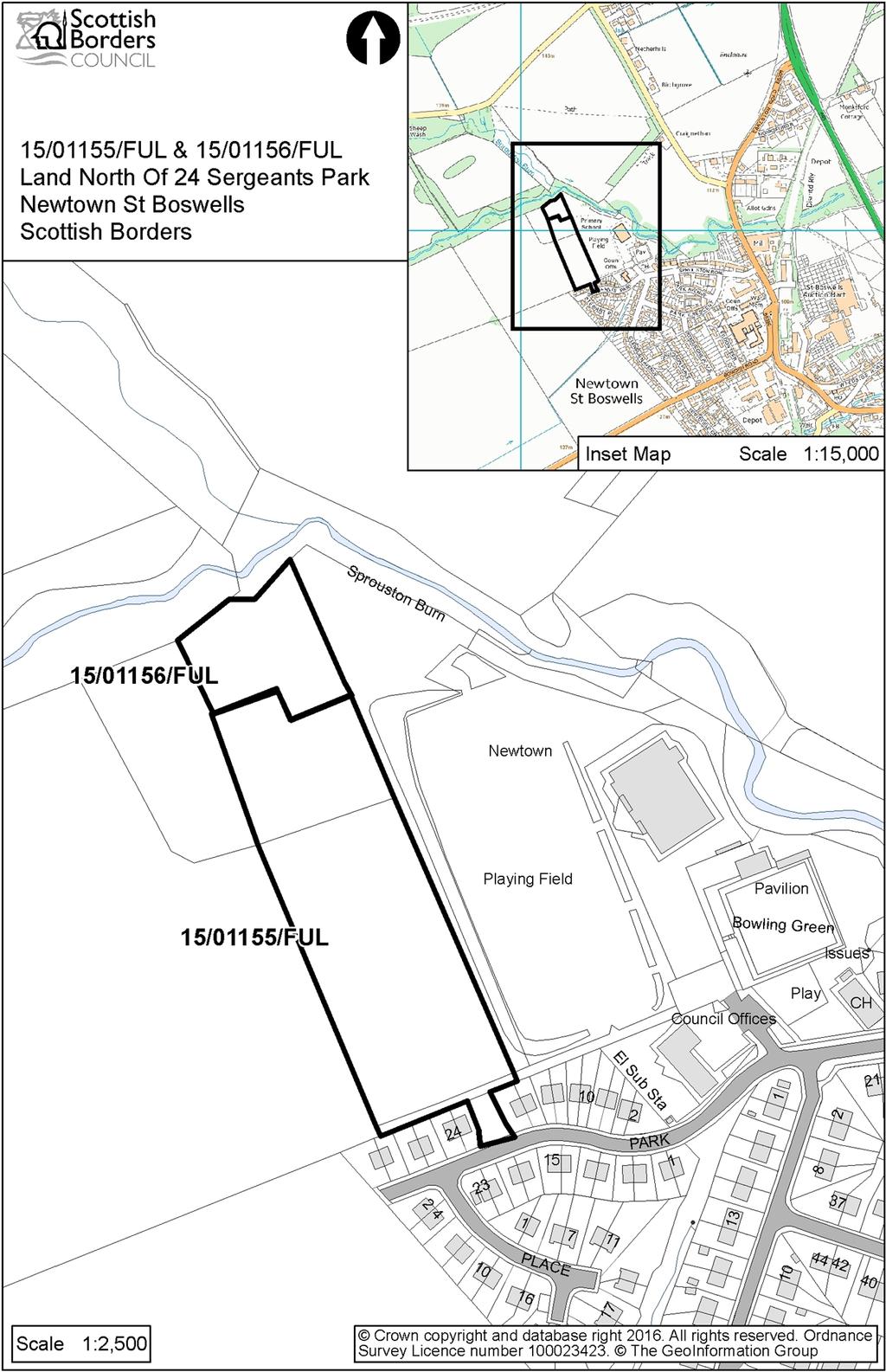
1 SCOTTISH BORDERS COUNCIL PLANNING AND BUILDING STANDARDS COMMITTEE 29 FEBRUARY 2016 APPLICATION FOR PLANNING PERMISSION ITEM: REFERENCE NUMBER: 1. 15/01155/FUL 2. 15/01156/FUL OFFICER: Julie Hayward WARD: Selkirkshire PROPOSAL: 1. Erection of 39 dwellinghouses, 2 flats and associated infrastructure (Phase 1) 2. Erection of 10 dwellinghouses, 2 flats and associated infrastructure (Phase 2) SITE: Land North of 24 Sergeants Park Newtown St Boswells APPLICANT: Queensberry Properties Ltd AGENT: Aitken Turnbull Architects Ltd SITE DESCRIPTION This is a combined report for two full planning applications for residential development within Newtown St Boswells. The combined site is 1.74 hectares in size and located on the north western edge of Newtown St Boswells. The site comprises of two overgrown agricultural fields. The land slopes down west to east towards the King George V playing field, bowling green and primary school. and Glenburnie and Sprouston Burns and associated woodland lie to the north and north east and there are fields to the west. The residential area of Sergeant s Park is to the south comprising of two-storey, semi-detached houses. The access to the site is between nos 20 and 22 Sergeant s Park. The site is within the Eildon and Leaderfoot National Scenic Area. PROPOSED DEVELOPMENT Two applications proposing, in effect, a single housing development are considered in this report: Application 15/01155/FUL is for the erection of 39 dwellinghouses and 2 flats (Phase 1) and application 15/01156/FUL is for 10 dwellinghouses and 2 flats (Phase 2) making a total of 53 units. The existing access on to Sergeant s Park would be upgraded to serve the site. The proposal is for semi-detached and terraced, single, one-and-three quarter and two storey dwellinghouses with two and three bedrooms. Seven house types are proposed arranged around the access road, with four units in the centre of the site. The walls would be blockwork with a dry dash render finish, some with timber boarding and porches, and there would be cast stone surrounds to the doors and windows. The roofs would be grey concrete tiles. A SUDS pond and car parking are proposed at the entrance of the site, with a parking courtyard screened by units 1 to 3. The existing footpath along the southern boundary of the site with the rear of the properties in Sergeant s Park would be retained and upgraded and a footpath link would be provided on the eastern 1
2 boundary to the playing field and on the western boundary to the field and expansion area. A 10m buffer zone along the eastern boundary of the site and a 5 10m zone along the northern boundary would be kept free of development to protect the existing mature trees. A turning area would be located in the north west corner of the site, with a possible future link through to the expansion site, and a total of 76 car parking spaces in Phase 1 and 20 in phase 2 are proposed The housing would be affordable housing built by the applicant and managed by Eildon Housing Association. Foul water drainage would be to the main Scottish Water sewer. A SUDS scheme would deal with the surface water drainage. PLANNING HISTORY 07/00002/FUL: Erection of 36 dwellinghouses and associated parking. Approved by 9 th March Awaiting completion of Section 75 Legal Agreement. REPRESENTATION SUMMARY Twelve representations have been received in respect of both applications. These are available to view in full on the Public Access system and the following planning issues have been raised: The existing foul water system is inadequate and overloaded and the proposed development would put more pressure on this system. Inadequate surface water drainage and flood risk. Increased traffic will cause congestion in an already busy street causing road safety issues, especially adjacent the school and play area. On-street parking already causes problems and the road and inadequate junction cannot cater with additional traffic. Sergeant s Park is on a steep incline and may become a danger to pedestrians and children during the winter. The proposed access to the site is not wide enough. The new road may be extended towards Green Wells creating a rat run to avoid the village. A roundabout should be constructed at the junction of Sprouston Road and Sergeant s Park adjacent to the Primary School. This junction is too narrow for the existing volume of traffic, with on-street parking. Sprouston Road is a 20 mph zone, showing this is a vulnerable area for pedestrians. Additional crossings or traffic control would be required. The roads are not wide enough for construction traffic, affecting the health and safety of residents. Noise nuisance from additional traffic. 2
3 Inadequate parking is proposed within the site which will cause parking to overflow into Sergeant s Park, which is already under pressure from people parking on the road. Smell nuisance from the SUDS pond. No play facilities are proposed, adding pressure to the existing play area. The right of way to the rear of Sergeant s Park should be accommodated within the development. Impact on water supply. Detrimental to residential amenity. The site will be enhanced with uninterrupted views of the Eildons. Access to the site should be considered within the context of the village expansion land, within the same ownership, keeping a safer village structure. APPLICANTS SUPPORTING INFORMATION: Drainage Report October 2015 Design and Access Statement Transport Technical Note January 2016 Preliminary Ecological Appraisal 2015 Landscape and Visual Impact Statement February 2016 CONSULTATION RESPONSES: Scottish Borders Council Consultees Roads Planning Service: When considering the overall impact of both these current applications on the surrounding road network, there are three aspects to consider: The immediate impact at the junctions between the site and the junction of the B6398 and the A68. Transport Scotland has not requested any alterations to the two junctions onto the A68 in respect of the current planning applications. However, when considering the overall development of Newtown St. Boswells as per the Council s Local Development Plan (LDP), a new roundabout will be required to replace the existing junction arrangement at the southerly end of the village. All development within Newtown St. Boswells will benefit and should therefore be included when considering whether or not any contributions are required towards the cost of this roundabout. It would seem fair and reasonable that the extent of any such contribution be proportional to the extent of traffic generation for the various proposals compared with the overall traffic generation for the expansion of the village as a whole. While a contribution towards any roundabout at the southerly A68 junction is strongly desirable and although it is referred to in the Supplementary Planning Guidance for the Development Framework for the village, there is no policy 3
4 requiring the roundabout provision and there is no funding mechanism or timescale for funding and provision in place. The effect of the traffic from these proposals on the Central Borders road network in line with the Central Borders Traffic Model. Following on from the Reporter s decision on the Meigle Row site in Clovenfords, the requirement and extent of contributions in respect of the Central Borders Traffic Model is currently under review and it would be inappropriate to seek any contributions at this time. That said, after some consideration, it is deemed the impact will be fairly minimal in respect of these proposals. The following matters must be addressed to the Council s satisfaction via the planning process: 1. The roads within the development shall require road construction consent (RCC) including the proposed servicing routes. 2. Appropriate SUDS must be provided and details of these must be submitted for approval and approved prior to works commencing on site. 3. Where any SUDS are outwith the public road boundary and are to be the maintenance responsibility of SBC, an appropriate legal agreement must be in place to ensure satisfactory access is available. 4. Confirmation must be provided that the applicant can provide the access off Sergeant s Park, including any associated embankments, within land they control. This is due to the apparent overlap of the site with the garden ground of no. 20 and the level differences in the vicinity. 5. Traffic figures for the junction of Sergeants Park, Sprouston Road and Glenburn Avenue are required. These will determine what improvements are required at this location, as highlighted within the development brief for the site. 6. The parking levels for this section of the site are inadequate; 96 spaces are required for the overall development. 7. The existing path along the south east boundary of the site (1 st Phase), and towards the school/play area, should be upgraded. 8. The existing road gully on Sergeant s Park must be relocated outwith the entrance bellmouth. Re-consultation: Whilst I welcome the provision of the 4 additional parking spaces, I have concerns regarding the loss of the pedestrian link adjacent to plot 21. Whilst this link may not appear to go anywhere at the moment, it will be critical for a link through to the next field as and when it is developed. If the link is not provided for in this phase, it will be lost in the future. It also results in the swept path for the roundel area being very close to the gable of the wall. As well as providing pedestrian routes, the footway will also provide some form of protection for the building. The applicant should be asked to reconsider how to accommodate the additional parking. Re-consultation: Whilst I am pleased the footpath link has now been provided, there are still issues regarding the parking within both phases of the development. In particular this relates to disabled bays. Re-consultation: There are still issues with the parking levels. Whilst I welcome the provision of dedicated disabled parking for the relevant properties, there will still be a requirement for disabled parking for visitors. As such, we shall still require the provision of at least 4 disabled bays throughout the development which will be adopted as public. Director of Education and Lifelong Learning: No response. 4
5 Housing Strategy: The development of this allocated housing site for affordable housing has been identified for future anticipated action for some years. This has been identified and prioritised as an affordable housing site in several Strategic Housing Investment Plans and is included as such within the current SBC SHIP 2015/20, which was signed off by Council in October 2014 prior to submission to the Scottish Government. The development of this site is also reflected in the current Strategic Local Programme Agreement 2016/20 between SG/RSLs/SBC for the purposes of programming Scottish Government Affordable Housing Investment Programme [grant] funding. The Scottish Government are aware of the emergence of this project following years of uncertainty and have indicated willingness to be flexible in provision of grants to enable timeous development of the site. It is anticipated that the Joint Venture Company, Queensberry, would develop the site, with Eildon HA proposing to enter into a design and build contract with the developer and that the homes built would be let at social housing rent levels. In addition, Eildon HA has also provided Bridge Homes the opportunity to acquire 4 of the 53 units for mid-market rent, subject to costs being clarified and acceptable and viable for Bridge Homes. Houses provided for mid-market rents are considered as being "affordable housing" for the purposes of the Councils Affordable Housing Policy. Environmental Health: This application has the potential to affect nearby occupiers. A condition requiring the submission of a Construction Method Statement and an informative on hours of working during construction are requested. Development Negotiator: This application comprises housing units which fully comply with Scottish Borders Council Affordable Housing Policy and would generate the following Development Contribution requirements: a commuted sum towards the provision and maintenance of additional play equipment and supporting ancillary infrastructures at a play facility outwith the site would be sought at a rate of 500 per dwelling unit. If an alternative facility is not identified for expansion, then it will be necessary for an appropriate infrastructure to be provided on-site, the factoring costs being conferred to incoming residents. Landscape Architect: The site is currently made up of two agricultural fields on the north west edge of Newtown St Boswells. Immediately to the north is the wooded Glenburnie Burn valley which provides a strong woodland backdrop and sense of enclosure to the fields immediately to the south. The eastern boundary lies adjacent to King George V playing field and wider open space. The southern boundary is delineated by a mixture of native and non-native hedging on the outside of timber fencing to the adjacent houses. There is a mixed native hedge along the western boundary, the hedge following the original boundary of the northernmost field. The site slopes from the western boundary to the east (132m AOD towards the north west corner while approximately 117m AOD) towards the south east corner. The site lies within the Eildon and Leaderfoot National Scenic Area that wraps around the west, north and east sides of Newtown St Boswells. The site lies within a River valley Landscape type described in the Borders Landscape Assessment (BLA) as 29 (Lower Tweed): Lowland valley with farmland and is located on the outer edge of this broad lowland valley type landscape. A Planning Brief for the whole (bigger) site was approved in February The approved development vision for this site is: A high quality residential environment is to be created within the site, with attention to the appropriate design and scale of 5
6 buildings and landscape fit including edge treatment, befitting its location as an edge of settlement development within the National Scenic Area. Suitable pedestrian connections should be provided linking the site to the centre of the settlement and to the wider path network Among Urban Design/Conservation/Cultural Heritage issues it requires Careful attention to be given to the edge treatment of the site including appropriate planting, hedging and pedestrian access linkages. The site is relatively well screened from immediate surrounding areas, the line of mature trees at the top of the playing field embankment providing valuable structure and screening from the playing fields, school and bowling green to the east, while the mature woodland along the Glenburnie Burn provides a backdrop and containment to the northern end of the development when viewed from elevated locations to the north, such as from Eildon North Hill. A basic Landscape and Visual Impact Statement (LVIS) was recently submitted. Ideally the LVIS should inform the site layout identifying issues that require mitigation. The photos are not of good quality however it does demonstrate that from the chosen viewpoints the site is not highly visible. Eildon North Hill is one of the potentially sensitive receptors but visibility of the site from successively more elevated points on the footpath up the north eastern flank is limited with the mature woodland strip along Glenburnie Burn providing significant screening of the site. The southern section of the western boundary will be visible but the visual impact of the houses along this boundary will be no greater than of the existing houses to the south which already form a very abrupt edge to the village. The density of residential units on the site means that there is virtually no ability to integrate the development into the wider landscape; any landscape screening to the western and northern boundaries relies on off-site trees and hedgerows and should these die or be removed there will be significant associated visual impacts. While I acknowledge that the land immediately to the west is zoned for expansion, I would suggest that this scheme, with no planting proposed whatsoever along the western edge, makes no attempt at a landscape fit. Within the development, apart from the area devoted to the SUDS, there is virtually no planting proposed with only a total of 9 trees contributing to the streetscape and a further 25 within back gardens, not enough to achieve a high quality residential environment. If the number of units were reduced to more closely reflect the proposed and surrounding house densities, as detailed in the Planning Brief, there would undoubtedly be more room for a quality streetscape to be achieved. This could include a central green in place of units 38, 39, 44 and 45 which would be beneficial to all the units that overlook this area or are accessed through it. The proposal lacks information about how level changes along the western boundary will be treated. The 11 car parking spaces in the south western corner of the site, which are right on the boundary, will be as much as 2.8m lower than the existing ground level, while the parking court and turning area to the north of Units 20 and 21 is as much as 3m lower than existing ground level along this boundary. No sections have been produced to illustrate and analyse proposed level changes and how they will be achieved. This is particularly relevant along this western boundary as the development is tight up against this boundary and the existing hedge which is shown outwith the site forms an important screen locally between the site and the adjacent land. The significant level changes along this western boundary will affect the water table to the extent that the existing hedge may not survive. The lack of any space for a replacement hedge or any edge treatment to this boundary is a real concern. 6
7 Despite the SUDS detention basin potentially providing some green space at the entrance to the site, I have concerns about how this area will be treated, as it should be part of the public open space. A design statement and strategy for the detention basin should be developed, including proposed levels and a detailed planting scheme that could be used to enhance the basin as a local amenity. Given that there is substantial screening, in the form of mature woodland belts, to the northern and eastern edges of the site, I do not think that a development in this location will have a significant detrimental impact on the character of the wider landscape or on quality of the NSA. However I do not consider that any attempt has been made to integrate the development into its immediate landscape. While there will, in the longer term, need to be a very much more robust landscape structure to the proposed western edge to the village, in the short term the western boundary of this site will be very exposed. No attempt has been made to address the issue of landscape fit required in the Planning Brief for this site. At the proposed unit density there is no opportunity for any hierarchy of open space which is regarded as central to creating the character of a neighbourhood. A fundamental rethink of the density would allow "placemaking" to be central to any amended site layout considerations. In addition to the above, as a condition of any consent, we will require detail on how proposed changes of level will be achieved, detail of how hard landscaping will be utilised to create a surfaces hierarchy and a detailed planting scheme to help reduce the impact of the walls and timber fencing in the streetscape. This proposal sacrifices the principle of a public/ private hierarchy of open space to maximise the number of units, and this reduces the ability to create a development with a clear sense of character and identity. The new road layout creates real possibilities for public open space but this has been sacrificed for increased numbers of units. A reduction in the number of units as suggested above would allow all my concerns to be addressed. Rights of Way Officer: There is one claimed right of way/core path on this area of land, namely BE180/CP209. This passes along the south-west side of the development; currently a gap of 1m width shown on the plan which is insufficient width to accommodate a path. A gap of 3m should be left to accommodate the path, which should be made up and surfaced to a width of 2m and the gate at the southwest corner of the site should be replaced with a multi-use metal gate. A contribution is required (a nominal sum of 16,400 which is 400 per dwelling) from the developer for the development, continued maintenance and promotion of a path network around Newtown St Boswells and linkages to neighbouring villages and places of interest. This contribution would be used to fund the production of promotional literature as well as drainage works, bridge maintenance, path surfacing and annual maintenance work on the wider Core and Promoted Paths Network, which would thus be strengthened through such a contribution from this development. Flood Protection Officer: In terms of information that this Council has concerning flood risk to this site, I would state that The Indicative River, Surface Water & Coastal Hazard Map (Scotland) known as the third generation flood mapping prepared by SEPA indicates that the site is not at risk from a flood event with a return period of 1 in 200 years. That is the 0.5% annual risk of a flood occurring in any one year. 7
8 As this site is not indicated to lie within the 1 in 200 year flood extent, I would have no objections to this proposal on the grounds of flood risk. I would, however, require the detailed design of the SUDS system to be submitted for approval by Scottish Borders Council. Ecology Officer: I am satisfied with the Preliminary Ecological Appraisal (PEA) carried out by Tweed Ecology. The site consists of poor semi-improved grassland. Hedgerows on the western boundary are species-poor; there is a line of mature lime trees along the eastern boundary with scattered hawthorn and hairy dog-rose. Along the northern field (15/01156/FUL) is an overgrown hedge on the eastern boundary with recent broad-leaved woodland planting. This plantation also includes an open area of species-rich unimproved neutral grassland. On the northern boundary is an area of mixed woodland plantation including beech, oak and sitka spruce. To the north-east of the site is an area of semi-natural woodland associated with the Sprouston Burn and Glenburnie Burn. The burns drain directly into the River Tweed SAC/SSSI. Protected species interest identified includes badger activity along the northern boundary and an outlier sett (located beyond potential disturbance distance from the development). Badger activity is likely to occur across the site and measures will be required to safeguard badgers during construction. Supplementary surveys for badger will also be required 3 months prior to construction. Three mature trees were identified as having moderate-high potential to support bat roosts. My understanding is that these trees are to be retained. If they are to be felled or managed, they will require a bat survey prior to any activity being carried out. The report also identifies mitigation to protect bat and badger interest through a sensitive lighting scheme during construction. The site includes habitats capable of supporting a range of farmland birds. Mitigation measures are identified in the PEA. Mitigation will be required for badger breeding birds and to address any potential impacts on the River Tweed SAC. Recommendations are made in the PEA to protect and enhance hedgerow and woodland boundary features. These features should be included in a Landscape and Habitat Management Plan. This should also include habitat measures associated with the SUDS feature, compensatory planting and enhancement of hedgerows along the western and eastern boundaries and also reinforcement of the northern boundary through a native broadleaf planting scheme. I note the recommendation for a 15m buffer area (from semi-natural broad-leaved woodland). Statutory Consultees Transport Scotland: The Director does not propose to advise against the granting of permission. Scottish Natural Heritage: Both of the proposed applications lie within the Eildon and Leaderfoot National Scenic Area, which is an area designated as one of Scotland s finest landscapes. The sites form part of a wider proposed extension to Newtown St Boswells as set out in Scottish Border Council s Proposed Development Plan. We consider the applications are lacking in information with regards to their role in maintaining or enhancing the qualities of the NSA and their role in addressing the 8
9 aims of the Newtown St Boswells Settlement statement and the approved Planning Brief for the site. Given their position on the current edge of the settlement, and in areas that may be visible from the popular peaks of the Eildon Hills, we would advise that further information is sought from the applicant with regards: the siting and design principles of the development and; the existing landscape features to be retained on the site and the detail of any proposed landscaping and night time lighting. In particular we would highlight the importance of achieving a co-ordinated and welldesigned urban edge that integrates built form with its surrounding rural context. However, due the specific location of the proposed developments within the NSA, and within a wider yet to be developed allocation as set out in the Proposed Plan, SNH does not wish to object to this application on the grounds of this lack of information or the likelihood that it would affect the objectives or overall integrity of the NSA. Nonetheless, we would advise that the Council secures appropriate information regarding the standards of detailed aspects of siting and design, landscaping, nighttime lighting and settlement edge design, in order to allow full understanding of the effects arising from this proposal. We would also advise that the development proposals submitted should be considered in relation to the role they may play in providing connections to existing public paths and future green network development, for example along the Sprouston Burn, which is likely to be important to supporting a larger population in the area and providing an appropriate setting for the future phases of settlement expansion allocated in the proposed Local Development Plan. We note that the pedestrian/cycle link that is set out in the Planning Brief is not proposed within either of these two applications. The proposals could affect the qualifying features of the River Tweed Special Area of Conservation. In our view, it is unlikely that the proposals will have a significant effect on any qualifying interests either directly or indirectly. An appropriate assessment is therefore not required. SEPA: 15/01155/FUL: We request that a condition is attached to the consent requiring a finalised scheme for sustainable drainage (SUDS) surface water treatment to be submitted. If this is not attached, then please consider this representation as an objection. A well designed SUDS scheme can form part of a wider green network, contribute to the amenity of the site and promote biodiversity. The SUDS treatment train should be followed which uses a logical sequence of SUDS facilities in series allowing run-off to pass through several different SUDS before reaching the receiving waterbody. We note that the Site Plan details that two levels of SUDS are proposed for the development. We welcome this as the development forms part of a larger two phase development (>50 units) and as such will require two levels of treatment. 9
10 We note that the proposed development will be utilising the public sewer for foul drainage. Therefore, we have no further comment to make on this issue and Scottish Water should be consulted to ensure there is sufficient capacity. 15/01156/FUL: We object to this planning application on the grounds of a lack of information relating to flood risk. We have reviewed the information provided and this shows the site lies adjacent to the 0.5% annual probability (1:200) flood extent of the Glenburnie Burn and as such is potentially at medium to high risk of flooding. This section of the watercourse is at the upper limit of the modelled extent and is also within a wooded area where topographical information may be less accurate leading to greater uncertainty within the flood map. Information should be provided to show the site to be sufficiently higher than the watercourse to be free from flood risk. This should include topographical information with existing and proposed site levels and cross sections of the watercourse. Photographs may also be useful and any other information on historic flood levels if available. Re-consultation: Following provision of topographic information showing the existing site to be over 3m above the Sprouston Burn and proposed site levels and finished floor levels to be raised further still, we are now in a position to remove our objection to this application on flood risk grounds. We are aware of flooding issues downstream on the Sprouston Burn and as such surface water runoff should be restricted to pre-development rates. Greenfield rates and method of attenuation should be agreed with Scottish Borders Council. Newtown and Eildon Community Council: The increased volumes of car movements are likely to create a safety hazard at the bottom junction and at the narrow entrance to the site. Currently the road width is often reduced by street parking and the additional traffic movements will aggravate the situation. Additional traffic control measures should be provided to ensure safety at the busy junction to the school, bowling club, Glenfield Avenue and Sprouston Road and the existing road congestion caused by parked cars could be alleviated by the provision of an additional off-street car parking space nearby. There is a history of serious flooding onto the football pitch, bowling green and school playground from this site. It is therefore critical that the SUDS pond capacity is adequate to prevent overflow. Safety around the perimeter of the SUDS pond and smells are issues. Blockages/overflows occur when heavy rain occurs suggesting that the sewer drainage could be working at maximum capacity. The proposed fence to the rear of Sergeant s Park along the footpath should have foliage planted to soften the appearance and a small number of car parking spaces are required for walkers. Access from the school to the new development is required and onto the right of way. Improvements to the right of way where it enters the Glen to the west of the development and on the path going down into the Glen and the steps leading out of the Glen the other side are required. It would be preferred that no separate play facilities be provided but for the 10
11 funds to be used to enhance the existing children's play area adjacent to the bowling club where there is space available to do this. With the increasing ageing population the village will need more sheltered housing in the future and it is disappointing to see none in this proposed development. The examples of the house designs show external staircases leading up to first floor properties with no shelter from the weather. The impact on the available view of the Eildons from existing properties. There is a need to mitigate the impact of construction traffic on residents and roads. Scottish Water: No response. Other Consultees None. DEVELOPMENT PLAN POLICIES: SES Plan Strategic Development Plan 2013 Policy 1B: The Spatial Strategy: Development Principles Scottish Borders Consolidated Local Plan Adopted 2011 Principle 1 Sustainability G1: Quality Standards for New Development G4: Flooding G5: Developer Contributions G6: Developer Contributions related to Railway Reinstatement NE1: International Nature Conservation Sites NE3: Local Biodiversity NE4: Trees, Woodlands and Hedgerows EP1: National Scenic Areas H1: Affordable Housing H2: Protection of Residential Amenity H3: Land Use Allocations Inf3: Road Adoption Standards Inf4: Parking Provisions and Standards Inf5: Waste Water Treatment Standards Inf6: Sustainable Urban Drainage Inf11: Developments that Generate Travel Demand Proposed Local Development Plan 2013 PMD1: Sustainability PMD2: Quality Standards PMD3: Land Use Allocations HD1: Affordable and Special Housing Needs HD3: Protection of Residential Amenity 11
12 EP1: International Nature Conservation Sites and Protected Species EP3: Local Biodiversity EP4: National Scenic Areas EP13: Trees, Woodlands and Hedgerows IS2: Developer Contributions IS3: Developer Contributions Related to the Borders Railway IS6: Road Adoption Standards IS7: Parking Provision and Standards IS8: Flooding IS9: Waste Water Treatment Standards and Sustainable Urban Drainage OTHER PLANNING CONSIDERATIONS: Supplementary Planning Guidance: Placemaking and Design January 2010 Guidance on Householder Development July 2006 Landscape and Development March 2008 Newtown St Boswells Development Framework February 2012 Affordable Housing January 2015 Developer Contributions April 2015 Biodiversity December 2005 Planning Brief Sergeants Park II Newtown St Boswells February 2006 KEY PLANNING ISSUES: The principal planning issues with this application can be summarised as follows: Whether the proposal would have an adverse impact on the National Scenic Area, landscape or visual amenities of the area. Whether the proposal would harm the residential amenity of neighbouring dwellings or conflict with the established land use of the area. Whether the proposals are acceptable in terms of parking, access and impacts on road safety. Whether adequate drainage and servicing can be achieved and whether the site is prone to flooding. ASSESSMENT OF APPLICATION: Planning Policy The site is situated within the development boundary for Newtown St Boswells within the Scottish Borders Consolidated Local Plan Adopted 2011 and is allocated for housing (ENT15B: Sergeants Park II) with an indicative capacity of 30 units on a 2 hectare site. Policy H3 of the Local Plan applies, which states that development will be approved in principle for the land uses allocated on the Land Use Proposals tables and maps in accordance with any approved planning brief. This allocation is also included within the Proposed Local Development Plan 2013 (policy PMD3 applies). The Planning Brief for the site was approved in 2006 and sets out the main opportunities and constraints relating to the site and creates an outline framework for its future development. 12
13 The Council s Supplementary Planning Guidance: Newtown St Boswells Development Framework February 2012 sets out the Council s approach to the successful development and regeneration of Newtown St Boswells with particular consideration to the relationship between the new development areas and the existing village centre. Figure 1 shows the main proposed areas for development and shows the site as an Adopted Local Plan housing site. The proposal would not conflict with the aims of the SPG. Layout and Design Policy G1 of the Local Plan requires all development to be of high quality in accordance with sustainability principles, designed to fit in with Borders townscapes and to integrate with its landscape surroundings. The aims and criteria of this policy are reiterated and expanded upon in policy PMD2 of the Local Development Plan. The Council s Supplementary Planning Guidance: Placemaking and Design January 2010 contains advice on developments of 50 or more houses on or near the settlement edge. The Planning Brief for the site requires issues such as planting, lighting, retention of existing vegetation, services and levels be considered in an integrative manner. A high quality of design and materials are required. A Design Statement has been submitted as part of the application. This site is located in a sensitive location at the edge of Newtown St Boswells within the Eildon and Leaderfoot National Scenic Area and would represent a significant addition to the village. This development also represents one of the first detailed proposals for housing development within Newtown St Boswells and the site is adjacent to the western expansion area and so would set a precedent for future developments within this allocation. It is therefore vital that a high level of design is achieved and a development that integrates well into the landscape that allows a sensitive transition between the built environment and rural area. Discussions have taken place with the agent regarding the layout and the revised proposal is now considered to be acceptable. It is accepted that this is a difficult site to develop due to its shape, topography and existing trees/vegetation and the easy option would be to have a linear form of development similar to that previously approved in The Council s Supplementary Planning Guidance on Placemaking and Design and the Newtown St Boswells Development Framework have been adopted since then and so it was considered that a higher standard of layout and design were now required. The access to the site is narrow, between two existing properties in Sergeants Park. This opens out to a bungalow and pair of semi-detached, one-and-three quarter storey houses on the western side and an area of open space incorporating the SUDS detention basin on the eastern side. A pair of semi-detached houses and a two storey building containing two flats front this open space and this provides an attractive arrival point. A row of houses would be situated adjacent to the western boundary. The estate road would loop around four houses within the centre of the site, which breaks up the long vista and avoids a linear development. The majority of the houses front the public realm providing a street through the development. There would be ten houses on the northern edge of the site and two flats. Parking would either be within curtilages or in parking courtyards and these have been designed to be screened by the houses so that parking does not form a dominant feature within the development. 13
14 The buildings fronting onto the road would be linked by walls rather than high timber fences. It is considered that the houses would relate to the public realm, fronting the road and framing the street, whilst varied building lines would add interest to the development. The layout of the road provides a variety of views and vistas throughout the site as well as providing natural traffic calming. The allocation for this site is 30 units but the proposal is for a total of 49 houses and 4 flats. Normally a lower density development would be appropriate for an edge of settlement site such as this. However, the higher density has resulted in an improved design and layout over the approved scheme, which is more consistent with Designing Streets and, as the development would be for affordable housing to be managed by a housing association, a higher density is considered to be acceptable. A condition would ensure that the housing is restricted to affordable housing that meets the Council s definition. The existing public right of way along the southern boundary of the site would be retained and upgraded and pedestrian links are proposed to the playing fields to the east and to the future housing development to the west. It is considered that proposed layout provides a logical sequence of streets and courtyards, creating a permeable development and the proposed number of houses and flats can be adequately accommodated within the site without it constituting overdevelopment. Newtown St Boswells is characterised by a mix of housing types. The village core and Sprouston Road has traditional stone and slate properties whereas the surrounding streets are predominantly two storey, modern, rendered houses. The proposal is for seven house types of single, one-and-three-quarter and two storey. The houses would have dry dash render and vertical timber boarding for the walls and grey roof tiles. The designs include vertically proportioned timber windows, front wings, timber porches and pitched roofed dormer windows. The designs are considered to be acceptable for the locality. The various designs, heights and building lines would add interest to the development. The wall-to-roof and wall-to-window ratios are adequate. The designs are considered to be simple in form and appropriate in scale, without the development appearing too cluttered, and would provide variety throughout the development. No play area is shown on the proposed layout. The nearest play park is in Sprouston Road adjacent to the primary school and within walking distance of the development, accessed by the upgraded right of way. A developer contribution towards the upgrading of the play area would be secured by a Section 69 Agreement. The layout has been designed so that the houses will front onto the road with minimal front gardens. Walls are proposed for the front boundaries of properties and for garden boundaries adjacent to the road rather than high fences. These would be 1.8m high and rendered and would provide an attractive and continuous frontage to the development. Rear gardens would be enclosed by 1.8m high timber fences to provide private garden ground. Planting will be required along the site boundaries to soften the impact of the development when viewed from outwith the site. A 1.8m fence was originally proposed around the detention basin but this was thought to result in an unattractive entrance to the site and so the fence has been removed. The agent has advised that the basin would normally be dry but less 14
15 obtrusive fencing could be erected if necessary on safety grounds and the surrounding open space would be landscaped. It is considered that the layout, design and materials are now acceptable and the application can be supported. Impact on the National Scenic Area, Landscape and Visual Amenities Policy G1 of the Local Plan requires appropriate boundary treatments and hard and soft landscaping works to help integration with the development s surroundings. Policy EP4 of the Proposed Local Development Plan 2013 states that development that may affect National Scenic Areas will only be permitted where the objectives of the designation and overall landscape value of the site and its surroundings will not be compromised and any significant adverse effects on the qualities for which the site or its surrounds have been designated are clearly outweighed by social or economic benefits of national importance. Policy NE4 of the Local Plan seeks to protect trees, woodlands and hedgerows from development. The Planning Brief requires careful attention to the edge treatment of the site including appropriate planting, hedging and pedestrian linkages. Buffers are required along the northern (20m) and eastern (10m) boundaries to protect the existing tree belts and landscaping is required within these buffers, with a tree belt within the northern buffer to supplement existing screening within the National Scenic Area. Existing hedges should be retained and supplemented. The site plan includes the two buffers, based on the root protection areas of the existing trees, though part of the northern buffer is within residential curtilages and is referred to as a no-build zone. No detailed planting scheme has been provided, though existing trees would be retained. Scottish Natural Heritage has not objected to the proposal on grounds of their likely impact on the Eildon and Leaderfoot NSA, but requested further information to ensure the delivery of appropriate standards of design and landscape integration of this development within the National Scenic Area. Additional information has been requested from the agent regarding the siting and design principles of the development, the existing landscape features to be retained on the site and the detail of any proposed landscaping and night time lighting to demonstrate that the development would achieve a co-ordinated and well-designed urban edge that integrates built form with its surrounding rural context, to satisfy the concerns of Scottish Natural Heritage. A brief Landscape and Visual Assessment has now been submitted. This concludes that near and mid distance views of the site are limited due to vegetation and the intervening landform; the tree belt along Sprouston and Glenburnie Burns provides a backdrop and the trees on the eastern boundary largely screen the site. Long distance views include the Eildon Hills and the site is some distance away and is read in the context of the settlement and so there is little impact on the landscape. Although the site is located in a sensitive location within the National Scenic Area it does read as a natural extension of the village, especially when considered in conjunction with the expansion area adjacent to it. It is an allocated housing site. The site would be visible from the Eildon Hills at a distance, with the mature woodland strip along Glenburnie Burn providing significant screening of the site. Visibility from the adjacent public road network is limited as it is well screened by existing mature trees, vegetation, topography and housing. The southern section of 15
16 the western boundary will be visible but the visual impact of the proposed houses along this boundary would be no greater than of the existing houses to the south. The site is not therefore, prominent in the landscape. It is vital that the existing trees are protected, retained and managed and this would be controlled by a planning condition. The buffer zones provide protection for these trees from development and also land within the site for appropriate planting to soften the impact of the development and help it to integrate into the landscape. A condition will require the submission of a planting scheme to achieve this, and also appropriate hedge enhancement and supplementary tree planting on the western boundary; this may require the reduction in the size of the rear gardens. It is accepted that the density of the development does not allow for large areas of public open space or landscaping within the development, though the buffer zones and area around the detention basin do provide opportunities for planting. It is considered that with appropriate planting and its long term maintenance the proposal would not harm the special qualities of the National Scenic Area, be prominent within the landscape or harm the visual amenities of the area. Any impact on the views of the Eildon Hills from existing properties caused by the development is not a planning issue that can be taken into account in determining these applications. Residential Amenity Policy H2 of the Local Plan states that development that is judged to have an adverse impact on the amenity of residential areas will not be permitted. This is replicated in policy HD3 of the Local Development Plan. Advice on light and privacy is contained within the Supplementary Planning Guidance: Guidance on Householder Developments July The houses within Sergeant s Park back onto the southern boundary of the site and the rear elevations of these properties are between 6 and 10m from the site boundary. The unit on plot 1 would be the closest to the southern boundary (5m); this would be a bungalow and sited at an angle to the site boundary so that no direct overlooking occurs and sited approximately 17m from the rear elevation of no.26 Sergeant s Park. Plots 2 and 3 would be two storey houses also sited at an angle to the site boundary and between 18 and 30m from the boundary. It is considered that the proposal would not harm the light or privacy of occupants of the houses within Sergeant s Park. Within the site the layout has resulted in dwellings being sited in close proximity, though there would be no direct window-to-window overlooking and adequate daylighting standards could be achieved. It is considered that an adequate residential environment can be achieved for future residents of the development. Environmental Health has requested that a Construction Method Statement is submitted prior to the development commencing. This would provide the operational parameters under which the development would be operated and managed and would include hours of operation, vehicle movement, the protection and monitoring of private water supplies, noise and dust mitigation and management and a complaints procedure to protect the amenity of nearby residential properties during construction. This would be secured by a condition. 16
17 Access and Parking Policy Inf3 of the Local Plan advises that new roads, footpaths and cycleways to be adopted by the Council will require Road Construction Consent and must be constructed to the Council s adopted standards. Policy Inf4 requires development proposals to provide for car parking in accordance with the Council s adopted standards. Policy Inf11 states that the Council is committed to guiding development to locations which are accessible to bus corridors and train stations and which maximise the opportunities for walking and cycling. The access to the site would be from Sergeant s Park, between nos. 20 and 22, and 96 car parking spaces are proposed, both in-curtilage and within courtyards. The existing right of way on the southern boundary would be upgraded and pedestrian links are proposed to the playing fields to the east and to the expansion area to the west. Provision has been made for a future vehicular link to the expansion area to the west. In terms of policy Inf11, the site is accessible by a range of transport options, being within walking distance of the bus stops on the main road through the village (the B6398) and accessible by cars and pedestrians. In addition, the site is close to the school and play area. Concerns have been raised by local residents regarding the increase in traffic generated by the development and the adequacy of the junction of Sergeants Park, Sprouston Road and Glenburn Avenue and the access to the site to cope with this increase in traffic. Concerns have also been expressed regarding the level of parking provided within the site exacerbating car parking problems on the existing streets causing congestion and road safety issues. Transport Scotland has no objections to the proposal and does not require any upgrading works at the two junctions from the B6398 onto the A68 or a roundabout on the A68 to accommodate this development. The Roads Planning Service has raised a number of concerns regarding whether the access from Sergeant s Park can be provided on land owned by the applicant, the SUDS scheme for the site, parking levels and traffic figures for the junction of Sergeants Park, Sprouston Road and Glenburn Avenue to determine what improvements are required at this junction. The agent has submitted a Technical Note containing the results of a vehicle, parking and pedestrian survey. The report concludes that the Sprouston Road/Glenburn Road/Sergeants Park priority junction is provided to an appropriate standard with significant remaining capacity and that no modifications are required. The Roads Planning Service has accepted the findings of this report and has not requested any improvement works to this junction. The agent has confirmed that the applicant owns all the land required to form the vehicular access to the site. An amended site plan has been submitted by the agent to address the parking requirements of the Roads Planning Service within the site. No developer contribution towards the upgrading, maintenance and promotion of the path network around Newtown St Boswells and linkages to neighbouring villages and places of interest can be sought as the proposal is for affordable housing. The site plan has been amended to include the upgrading of the right of way on the southern boundary of the site as required by the Council s Access Officer. The site layout also 17
18 includes links to the playing field to the east and fields to the west, part of the future expansion area. It would still be possible to access the footpath network from the site. There is no requirement to provide parking within the site for walkers using the footpath network in the surrounding area as no existing public parking would be lost as a result of the development, though on-street parking is available for visitors to the site. Natural Heritage Policy NE3 of the Local Plan states that the Council will seek to safeguard the integrity of habitats within and outwith settlements which are of importance for the maintenance and enhancement of local biodiversity. Policy EP3 of the Local Development Plan states that development that would have an unacceptable adverse effect on Borders Notable Species and Habitats of Conservation Concern will be refused unless it can be demonstrated that the public benefits of the development outweigh the value of the habitat for biodiversity conservation. The Planning Brief requires the submission of an Ecological Impact Assessment. The agent has submitted A Preliminary Ecological Appraisal and this concludes that there are no protected species within the site and the habitat within the site is only of local nature conservation value. Mitigation measures are proposed to minimise the ecological impact of the development and recommendations on the future management of hedgerows. Scottish Natural Heritage advises that the development is unlikely to have a significant effect on any qualifying interests of the River Tweed Special Area of Conservation. The Council s Ecology Officer requires mitigation measures for badger, breeding birds and to address any potential impacts on the River Tweed SAC. A Landscape and Habitat Management Plan is also required with measures to protect and enhance hedgerow and woodland boundary features, habitat measures associated with the SUDS feature, compensatory planting and enhancement of hedgerows along the western and eastern boundaries and also reinforcement of the northern boundary through a native broadleaf planting scheme. These requirements would be secured through conditions. Flooding Policy G4 of the Local Plan refers to developments where there is an identified flood risk; developments will not be permitted if it would be at significant risk of flooding or would materially increase the risk of flooding elsewhere. Policy IS8 of the Local Development Plan advises that as a general principle, new development should be located in areas free from significant flood risk and developments will not be permitted if it would be at significant risk of flooding or would materially increase the probability of flooding elsewhere. The ability of flood plains to convey and store flood water should be protected. SEPA objected to the application for Phase 2 as the site lies adjacent to the 0.5% annual probability (1:200) flood extent of the Glenburnie Burn and as such is potentially at medium to high risk of flooding. The agent provided additional topographic information showing the existing site to be over 3m above the Sprouston 18
19 Burn and proposed site levels and finished floor levels and SEPA has removed their our objection to the application. They are aware of flooding issues downstream on the Sprouston Burn and advise that surface water runoff should be restricted to predevelopment rates. Drainage Policy Inf5 of the Local Plan requires direct connection to the public sewerage system for foul water drainage and policy Inf6 requires a Sustainable Urban Drainage System for surface water drainage. The Community Council has expressed concern regarding the serious flooding of the playing field and bowling green from this site and request that the SUDS pond is adequate to prevent run-off onto adjacent land and flooding. A Drainage Report has been submitted with the application. Foul water would connect to the Scottish Water sewer on Sergeant s Park and would be designed to be adopted by Scottish Water. Surface water drainage would be via a SUDS system, draining to the south of the site where it will be attenuated before discharging into the Scottish Water surface water network. Attenuation will take the form of a detention basin at the entrance to the site. No specific design has been submitted but the report acknowledges that the SUDS must be designed in accordance with Council and SEPA requirements and, as the site is undeveloped, it is necessary to match any developed runoff from the site to the appropriate greenfield pre-development flows (a requirement of SEPA). The SUDS would then be adopted and maintained by Scottish Water. Scottish Water has confirmed in a letter to the agent that there is sufficient capacity in the Newtown St Boswells Waste Water Treatment Works and the local network to service the demands of the development. They require that surface water should discharge to the nearby surface water mains in Sergeant s Park, which eventually discharges to the Sprouston Burn, and this should be attenuated to greenfield rates and SUDS treatment applied accordingly. The water supply would be from the Scottish Water mains supply. A condition will require the submission of a detailed SUDS scheme and details of the long term maintenance for approval in consultation with SEPA and the Roads Planning Service. Provided the SUDS scheme is operated and maintained in accordance with the approved details, the detention basin should not result in any smell nuisance to local residents. Developer Contributions Policy G5 of Local Plan states that where a site is acceptable but cannot proceed due to deficiencies in infrastructure or due to environmental impacts the Council will require developers to make contributions towards the cost of addressing such deficiencies. Policy G6 requires a financial contribution towards the reinstatement of the Borders railway. 19
20 The proposal is for affordable housing managed by Eildon Housing Association and so no contributions are required towards Earlston High School, Newtown St Boswells Primary School or the Borders Railway. A commuted sum, however, is required towards the provision and maintenance of additional play equipment and supporting ancillary infrastructures at a play facility outwith the site and this will be secured through a Section 69 Legal Agreement. A condition would ensure that the development complies with the Council s definition of affordable housing. CONCLUSION The proposed residential development, subject to the imposition of planning conditions, is considered acceptable and in compliance with policies G1, H2, H3 and Inf4 of the Scottish Borders Consolidated Local Plan Adopted The proposed use is appropriate for this part of Newtown St Boswells. The layout of the site and design and external materials of the proposed buildings are considered to be acceptable and it is not considered that the proposal would negatively impact upon the character of the area, residential amenities, the special qualities of the National Scenic Area or the visual amenities of the area. Adequate on-site parking, access, drainage and servicing can be achieved. The proposal also complies with the relevant policies within the Proposed Local Development Plan RECOMMENDATION BY SERVICE DIRECTOR (REGULATORY SERVICES): I recommend the applications 15/01155/FUL and 15/01156/FUL are approved subject to a legal agreement addressing contribution towards play facilities and the following conditions: 1. The proposed residential units shall meet the definition of "affordable housing" as set out in the adopted Scottish Borders Consolidated Local Plan Adopted 2011 and any accompanying supplementary planning guidance and shall only be occupied in accordance with arrangements (to include details of terms of occupation and period of availability) which shall first have been submitted to and approved in writing by the Planning Authority. Reason: The permission has been granted for affordable housing, and development of the site for unrestricted market housing would not comply with development plan policies and guidance with respect to contributions to infrastructure and services, including local schools. 2. The development hereby permitted shall not be carried out otherwise than in complete accordance with the plans and specifications approved by the Planning Authority, unless otherwise approved by the Planning Authority. Reason: To ensure that the development is carried out in accordance with the approved details. 3. The development hereby approved shall only be carried out in strict accordance with a programme of phasing which has first been submitted to and approved in writing by the Planning Authority. This to include the provision of footpath links to the land to the east and west of the site. Reason: To ensure that the development proceeds in an orderly manner. 4. Notwithstanding the description of the materials in the application, no development shall be commenced until a sample of all materials to be used on all exterior surfaces of the development hereby permitted (including walls, 20
21 roofs, window frames, external doors, boundary walls and fences) has been submitted to and approved in writing by the Planning Authority and thereafter no development shall take place except in strict accordance with those samples. Reason: The materials require further consideration to ensure a satisfactory form of development, which contributes appropriately to its setting. 5. Details of the lighting within the site to be submitted to and approved in writing by the Planning Authority before the development commences. The lighting then to be installed as per the approved details. Reason: Reason: In the interests of road and pedestrian safety and to safeguard residential amenities and limit light pollution. 6. No development shall commence until a Construction Method Statement has been submitted to and approved in writing by the Planning Authority. As a minimum this should outline how the site will comply with the British Standard 5228:2009 Code of Practice for noise and vibration control on construction and open sites and should include the hours of construction, vehicle movements, protection and monitoring of private water supplies, noise mitigation, equipment maintenance, dust mitigation and management and a complaints procedure/communication of noisy works to receptors. The development then to be carried out in accordance with the approved Construction Method Statement. Reason: To safeguard residential amenities. 7. No development to commence until a scheme detailing proposals for sustainable drainage (SUDS) surface water treatment has been submitted to and approved in writing by the Planning Authority, in consultation with SEPA. The development to be completed in accordance with the approved scheme. The scheme shall be developed in accordance with the technical guidance contained in The SUDS Manual (C753) and should incorporate source control. Reason: To ensure adequate protection of the water environment from surface water run-off. 8. No development shall take place except in strict accordance with a scheme of soft landscaping works, which shall first have been submitted to and approved in writing by the Planning Authority, and shall include: i. indication of existing trees, shrubs and hedges to be removed, those to be retained and, in the case of damage, proposals for their restoration; ii. location of new trees, shrubs, hedges and grassed areas; iii. schedule of plants to comprise species, plant sizes and proposed numbers/density; iv. programme for completion and subsequent maintenance. Reason: To enable the proper form and layout of the development and the effective assimilation of the development into its wider surroundings. 21
22 9. No trees within the application site shall be felled, lopped, lifted or disturbed in any way without the prior consent of the Planning Authority. Reason: The existing trees represent an important visual feature which the Planning Authority considered should be substantially maintained. 10. Before any part of the permitted development is commenced, the trees to be retained on the site shall be protected by a heras or similar fence 1.5 metres high, placed at a minimum radius of one metre beyond the crown spread of each tree, and the fencing shall be removed only when the development has been completed. During the period of construction of the development: (a) No excavations, site works, trenches or channels shall be cut, or pipes or services laid in such a way as to cause damage or injury to the trees by interference with their root structure; (b) No fires shall be lit within the spread of the branches of the trees; (c) No materials or equipment shall be stored within the spread of the branches of the trees; (d) Any accidental damage to the trees shall be cleared back to undamaged wood and be treated with a preservative if appropriate; (e) Ground levels within the spread of the branches of the trees shall not be raised or lowered in relation to the existing ground level, or trenches excavated except in accordance with details shown on the approved plans. Reason: In the interests of preserving the health and vitality of existing trees on the development site, the loss of which would have an adverse effect on the visual amenity of the area. 11. No hedges within or on the boundaries of the application site shall be removed, damaged or disturbed in any way without the prior consent of the Planning Authority. Reason: The existing hedges represent an important visual feature which the Planning Authority considered should be substantially retained and maintained. 12. Before any part of the permitted development is commenced, the hedges to be retained on the site shall be protected by a heras or similar fence 1.5 metres high placed at a minimum distance of 2.0 metres from the edge of the hedge, and the fencing shall be removed only when the development has been completed. During the period of construction of the development the existing soil levels around the boles of the hedges so retained shall not be altered. Reason: In the interests of preserving the hedges which contribute to the visual amenity of the area. 13. A design statement and strategy for the detention basin to be submitted to and approved in writing by the Planning Authority before the development commences. This to include proposed levels and a detailed planting scheme (including a timescale for completion and details of future maintenance). The development then to be completed in accordance with the approved scheme. Reason: To enhance the basin as a local amenity. 14. Detailed drawings showing how the proposed changes of level within the site will be achieved, including sections, existing and proposed ground levels, any retaining walls and how the ground around trees and hedges will be treated, to be submitted to and approved in writing by the Planning Authority before 22
23 the development commences. The development then to be completed in accordance with the approved details. Reason: To safeguard trees and hedges within the site. 15. The existing hedges on the site boundaries to be outwith the garden ground of the dwellinghouses hereby approved, unless otherwise agreed with the Planning Authority, and to be separated from the garden ground of the dwellinghouses by a post and wire fence or similar, erected prior to the occupation of the dwellinghouses, the details of which are to be submitted to and approved by the Planning Authority before the development commences. Reason: In the interests of preserving the hedges which contribute to the visual amenity of the area. 16. No development of any sort to take place within the buffer zones at any time. Where proposed fence posts are to be erected beneath tree canopies, the developer shall carry out all excavation by hand digging where necessary, taking such further precautions as may be necessary to prevent any damage to any tree or its root system. Reason: To safeguard the buffer zones from development to protect the existing mature trees within and adjacent to the site. 17. Prior to the commencement of works on the site a Species Mitigation and Management Plan (including a Badger Protection Plan and measures for bats and breeding birds) to be submitted to and approved in writing by the Planning Authority. All works shall thereafter be carried out in accordance with the approved plan. Reason: To protect protected species within and adjacent to the site Prior to the commencement of works on-site a Construction Environmental Management Plan to be submitted to and approved in writing by the Planning Authority. This to include measures to prevent pollution, as identified in the Preliminary Ecological Appraisal 2015 and the consultation responses from Scottish Natural Heritage and SEPA. All works shall thereafter be carried out in accordance with the approved plan. Reason: To control drainage and pollution to protect the interest of the River Tweed SAC/SSSI. 19. Prior to the commencement of works on-site a Landscape and Habitat Management Plan to be submitted to and approved in writing by the Planning Authority. This to include measures to protect and enhance hedgerow and woodland boundary features, as identified in the Preliminary Ecological Appraisal 2015, and measures associated with the SUDS feature. All works shall thereafter be carried out in accordance with the approved plan. Reason: To protect and enhance hedgerow and woodland boundary features. 20. The surfacing for the proposed roads, footpaths and parking spaces shall be submitted to and approved in writing by the Planning Authority before the development commences. The development then to be completed in accordance with the approved details. Reason: To ensure that the proposed development is laid out in a proper manner with adequate provision for traffic and in a manner which enhances the character and visual appearance of the development. 21. The proposed roads, footpaths and parking spaces/areas indicated on the approved drawings shall be constructed to ensure that each 23
24 dwellinghouse/flat, before it is occupied, shall be served by a properly consolidated and surfaced carriageway, parking area and footpath/shared surface. Reason: To ensure that the proposed development is laid out in a proper manner with adequate provision for traffic and pedestrians. 22. The right of way along the southern boundary of the site to be upgraded, as per Drawing Number PL1-01D, before the first dwellinghouse is occupied. The right of way then to be kept open and free from obstruction or encroachment during the construction of the dwellinghouses and thereafter. Reason: To ensure the right of way remains open and free from obstruction. Informatives In respect of condition 6, the Control of Pollution Act 1974 allows the Council to set times during which work may be carried out and the methods used. The following are the recommended hours for noisy work: Monday Friday Saturday Sunday (Public Holidays) no permitted work (except by prior notification to Scottish Borders Council. Contractors will be expected to adhere to the noise control measures contained in British Standard 5228:2009 Code of practice for noise and vibration control on construction and open sites. For more information or to make a request to carry out works outside the above hours please contact an Environmental Health Officer. The consultation response from SEPA, Scottish Natural Heritage and the Council s Ecology Officer and Landscape Architect are attached for the information of the applicant. DRAWING NUMBERS 15/01155/FUL: L(01)101 Site Location Plan EX-01 Existing Levels PL1-01D Site Plan Phase 1 PP1-A House Type A Floor Plans and Elevations PP1-B House Type B Floor Plans and Elevations PP1-B2 House Type B2 Floor Plans and Elevations PP1-BC House Type B-C Floor Plans and Elevations PP1-C House Type C Floor Plans and Elevations PP1-D House Type D Floor Plans and Elevations PP1-E House Type E Floor Plans and Elevations PP1-F House Type F Floor Plans and Elevations PP1-G House Type G Floor Plans and Elevations P1&2-V1B Visuals Phase 1 & 2 Visuals 1 of 2 P1&2-V2 Visuals Phase 1 & 2 Visuals 2 of 2 PPBT-01C Boundary Treatments 15/01156/FUL: L(01)102 Site Location Plan 24
25 EX-01 Existing Levels PL2-01D Site Plan Phase 2 PP2-BC House Type B-C Floor Plans and Elevations PP2-G House Type G Floor Plans and Elevations P1&2-V1B Visuals Phase 1 & 2 Visuals 1 of 2 P1&2-V2 Visuals Phase 1 & 2 Visuals 2 of 2 PPBT-01C Boundary Treatments Approved by Name Designation Signature Ian Aikman Chief Planning Officer The original version of this report has been signed by the Service Director (Regulatory Services) and the signed copy has been retained by the Council. Author(s) Name Julie Hayward Designation Lead Planning Officer 25
26 26
Derry City and Strabane District Council Planning Committee Report. Amended layout from approval A/2004/0462/F with reduction from 166 units
 Derry City and Strabane District Council Planning Committee Report COMMITTEE DATE: 1 st February 2017 APPLICATION No: APPLICATION TYPE: PROPOSAL: LOCATION: APPLICANT: AGENT: Full Planning application Amended
STATEMENT OF OBJECTION TO THE PROPOSED DEVELOPMENT OF LAND AT CHURCH CLIFF DRIVE FILEY
 STATEMENT OF OBJECTION TO THE PROPOSED DEVELOPMENT OF LAND AT CHURCH CLIFF DRIVE FILEY You will be aware that Scarborough borough council have adopted a new local plan that includes land at Church Cliff
Statement of Community Involvement LAND OFF SOUTHDOWN ROAD HORNDEAN, HAMPSHIRE
 LAND OFF SOUTHDOWN ROAD HORNDEAN, HAMPSHIRE CONTENTS Page 1. Introduction 3 2. Pre-application Discussions 4 3. The Consultation Process 5 4. Consultation Feedback 7 5. Responses to Consultation Feedback
SOUTH CAMBRIDGESHIRE DISTRICT COUNCIL. Planning and New Communities Director
 SOUTH CAMBRIDGESHIRE DISTRICT COUNCIL REPORT TO: Planning Committee 5 June 2013 AUTHOR/S: Planning and New Communities Director S/0747/13/FL HISTON Construction of Car Park at Histon Baptist Church, Station
1. Local Plan Context
 1. Local Plan Context WHY ARE YOU HERE? ABOUT US PLANNING APPLICATION CONSULTATION Stewart Milne Homes are in the process of preparing a detailed planning application for a development of approximately
PLANNING COMMITTEE DATE: 07/09/2015 REPORT OF THE SENIOR MANAGER PLANNING AND ENVIRONMENT SERVICE CAERNARFON. Number: 4
 Number: 4 Application Number: C15/0034/37/LL Date Registered: 21/05/2015 Application Type: Full - Planning Community: Llanaelhaearn Ward: Llanaelhaearn Proposal: Location: Summary of the Recommendation:
Derry City and Strabane District Council Planning Committee Report
 Derry City and Strabane District Council Planning Committee Report COMMITTEE DATE: 23 rd March 2016 APPLICATION No: APPLICATION TYPE: PROPOSAL: LOCATION: APPLICANT: LA11/2015/0395/F Residential Development
SCOTTISH BORDERS COUNCIL PLANNING AND BUILDING STANDARDS COMMITTEE 25 APRIL 2016 APPLICATION FOR PLANNING PERMISSION IN PRINCIPLE
 SCOTTISH BORDERS COUNCIL PLANNING AND BUILDING STANDARDS COMMITTEE 25 APRIL 2016 APPLICATION FOR PLANNING PERMISSION IN PRINCIPLE ITEM: OFFICER: WARD: PROPOSAL: SITE: APPLICANT: AGENT: REFERENCE NUMBER:
Welcome to our exhibition
 Welcome to our exhibition The Homes & Communities Agency (HCA) welcomes you to this public exhibition explaining our proposals for the redevelopment of the former Lea Castle Hospital site. About the Homes
Perth and Kinross Council Development Management Committee 20 February 2013 Report of Handling by Development Quality Manager
 Perth and Kinross Council Development Management Committee 20 February 2013 Report of Handling by Development Quality Manager 4(4)(iii) 13/81 Erection of sports hall, associated changing facilities, offices
Perth and Kinross Council Development Management Committee 8 June Pre-Application Report by Development Quality Manager
 Perth and Kinross Council Development Management Committee 8 June 2016 5(3)(i) 16/259 Pre-Application Report by Development Quality Manager Residential development at St Martins Road, Land 120 metres West
Welcome to our Public Consultation
 About our development This exhibition gives you the chance to view and comment on our emerging plans for a proposed residential development located on land to the West of Alwyn Road, Rugby. Welcome to
Welcome to our public exhibition
 About our development Welcome to our public exhibition This exhibition gives you the chance to view and comment on our proposals for a new residential development of 165 high-quality homes, along with
Welcome to our public exhibition
 About Our Scheme Welcome to our public exhibition This exhibition gives you the chance to view and comment upon our emerging proposals for a new residential development of 68 new homes on the site of the
SOUTH CAMBRIDGESHIRE DISTRICT COUNCIL. Executive Director (Operational Services) Corporate Manager (Planning and New Communities)
 Corporate Manager (Planning and New Communities)") SOUTH CAMBRIDGESHIRE DISTRICT COUNCIL REPORT TO: Planning Committee 12 January 2011 AUTHOR/S: Executive Director (Operational Services) Corporate Manager (Planning and New Communities) Notes: S/1848/10
SOUTH CAMBRIDGESHIRE DISTRICT COUNCIL REPORT TO: Planning Committee 12 January 2011 AUTHOR/S: Executive Director (Operational Services) Corporate Manager (Planning and New Communities) Notes: S/1848/10
CALA HO ME S WELCOME
 WELCOME Welcome to this public consultation event for our proposed residential development of 56 high quality homes on land to the north east of Station Road in Earls Colne. Thank you for taking the time
Kibworth Harcourt. Introduction. Introduction
 Introduction Introduction Welcome to this public exhibition on the proposals for the delivery of new homes on land at The Kibworths. The purpose of today s exhibition is to give you the opportunity to
Harrow Lane, St Leonards-on-Sea, East Sussex, TN37 7JZ ERECTION OF 113 DWELLINGS TOGETHER WITH ESTATE ROADS (DETAILED SUBMISSION)
") AGENDA ITEM NO: Report to: PLANNING BOARD Date: 10 September, 2003 Report from: Borough Planning Officer Application Address: Proposal: Application No: Recommendation: Ward: File No: Applicant: Interest:
AGENDA ITEM NO: Report to: PLANNING BOARD Date: 10 September, 2003 Report from: Borough Planning Officer Application Address: Proposal: Application No: Recommendation: Ward: File No: Applicant: Interest:
Site north of Hattersley Road West (east of Fields Farm Road), Hattersley
, Hattersley") Application Number 17/00982/REM Proposal Site Applicant Recommendation Reason for report Application for the approval of reserved matters (means of access, landscaping, layout, scale and appearance) relating
Application Number 17/00982/REM Proposal Site Applicant Recommendation Reason for report Application for the approval of reserved matters (means of access, landscaping, layout, scale and appearance) relating
List of Policies. SESPlan. None applicable. Consolidated Scottish Borders Local Plan 2011: POLICY G1 - QUALITY STANDARDS FOR NEW DEVELOPMENT
 List of Policies Local Review Reference: 15/00021/RREF Planning Application Reference: 15/00616/FUL Development Proposal: Installation of 16no solar photovoltaic (PV) panels to roof Location: Raebank,
WELCOME. Land North of STEVENAGE. We would like to thank you for attending our public exhibition today.
 WELCOME We would like to thank you for attending our public exhibition today. The purpose of this event is to share our proposals and hear your thoughts on our ideas. Members of the project team are on
Land at Rampton Road. Cottenham
 Land at Rampton Road Cottenham Introduction TEP is preparing an outline planning application for 54 dwellings on 6.9 hectares of land adjacent to Rampton Road, Cottenham on behalf of the owners Cambridgeshire
Warren Farm, Ampthill
 1 Welcome The developers of the Warren Farm site, Bloor Homes and Connolly Homes, are holding this exhibition on the emerging Design Codes for the development prior to their formal submission to Central
1 The development hereby permitted shall be carried out in accordance with the following approved plans:
 Location 59 Greenway Close London N20 8ES Reference: 16/00011/HSE Received: 30th December 2015 Accepted: 7th January 2016 Ward: Totteridge Expiry 3rd March 2016 Applicant: Mr Ankit Shah Proposal: Part
Welcome to our public exhibition
 About our scheme Welcome to our public exhibition Taylor Wimpey East Anglia intends to submit a detailed planning application for a new residential development of 39 high-quality homes at the B&M Concrete
1 The development hereby permitted shall be carried out in accordance with the following approved plans:
 Location The Avenue Tennis Club The Avenue London N3 2LE Reference: 16/6509/FUL Received: 10th October 2016 Accepted: 10th October 2016 Ward: Finchley Church End Expiry 5th December 2016 Applicant: Mrs
Persimmon Homes Thames Valley Date received: 2 nd April week date(major): 2 nd July 2014 Ward: Nascot
: 2 nd July 2014 Ward: Nascot") PART A Report of: DEVELOPMENT MANAGEMENT SECTION HEAD Date of Committee: 26 th June 2014 Site address: Rounton, 28, Nascot Wood Road Reference Number: 14/00497/REM Description of Development: Reserved
PART A Report of: DEVELOPMENT MANAGEMENT SECTION HEAD Date of Committee: 26 th June 2014 Site address: Rounton, 28, Nascot Wood Road Reference Number: 14/00497/REM Description of Development: Reserved
DESIGN & ACCESS STATEMENT
 DESIGN & ACCESS STATEMENT Land to the South East of the A495, Bronington Erection of 31 Dwellings (27 dwellings and 4 bungalows including 4 Affordable Dwellings), Realignment and Improvements to A495 (including
Ground Floor Flat 15 Redbourne Avenue London N3 2BP
 Location Ground Floor Flat 15 Redbourne Avenue London N3 2BP Reference: 17/4160/FUL Received: 28th June 2017 Accepted: 29th June 2017 Ward: West Finchley Expiry 24th August 2017 Applicant: Proposal: Mr
BRIDGE OF DON MASTERPLAN & PLANNING SUMMARY
 BRIDGE OF DON MASTERPLAN & PLANNING SUMMARY SITE LOCATION The site of the existing AECC lies in an area of predominately residential and business use in Bridge of Don and extends approximately 50 acres.
PHASE III: Reserved Matters Submission
 Statement of Compliance with the outline approval for the proposed residential development of land at: BURGES LANE, WIVELISCOMBE PHASE III: Reserved Matters Submission Foreword Contents: This Statement
New Homes at Winton East
 View toward Winton East from Caerketton Hill Aerial photograph of South Edinburgh: Winton East Site Location Indicative proposal Welcome Thank you for coming to the Winton East public exhibition. We would
PDP DESIGN & ACCESS STATEMENT
 PDP The Planning & Design Partnership Planning.. Architecture.. Interiors.. Landscape The Chicory Barn Studio, The Old Brickyards, Moor Lane, Stamford Bridge York, The East Riding Of Yorkshire, YO41 1HU.
Schedule of Planning Applications Committee Date: 23 May Reference: 06/17/0726/F Parish: Hemsby Officer: Mr J Beck Expiry Date:
 Schedule of Planning Applications Committee Date: 23 May 2018 Reference: 06/17/0726/F Parish: Hemsby Officer: Mr J Beck Expiry Date: 22-05-2018 Applicant: Proposal: Site: Mr Gillett Change of use to the
Newcourt Masterplan. November Exeter Local Development Framework
 Newcourt Masterplan November 2010 Exeter Local Development Framework Background The Exeter Core Strategy Proposed Submission sets out the vision, objectives and strategy for the development of Exeter up
CA//16/00504/FUL. Canterbury City Council Military Road Canterbury Kent CT1 1YW. Crown copyright and database rights 2016 Ordnance Survey
 O Scale 1:1,250 Map Dated: 09/05/2016 CA//16/00504/FUL Crown copyright and database rights 2016 Ordnance Survey 100019614 Canterbury City Council Military Road Canterbury Kent CT1 1YW AGENDA ITEM NO 13
Replacement Golf Course Facilities and Residential Development, Churston. Environmental Statement Non-Technical Summary
 Replacement Golf Course Facilities and Residential Development, Churston Environmental Statement Non-Technical Summary July 2011 Reproduced from the Ordnance Survey s map with the permission of the Controller
LONGDEN VILLAGE DEVELOPMENT STATEMENT
 LONGDEN VILLAGE DEVELOPMENT STATEMENT 2017-2027 1 Longden Development Statement 2017-2027 15/01/18 1. Background 1.1 Longden Village Longden village is a very rural and traditional community first mentioned
DEVELOPMENT MANAGEMENT REPORT
 ITEM A08-1 DEVELOPMENT MANAGEMENT REPORT TO: BY: DATE: DEVELOPMENT: SITE: WARD: APPLICATION: APPLICANT: Development Management Committee Development Manager Proposed live/work unit in connection with existing
Change Paper / Date CAIRNGORMS NATIONAL PARK AUTHORITY
 Change Paper / Date CAIRNGORMS NATIONAL PARK AUTHORITY Title: Prepared by: REPORT ON CALLED-IN PLANNING APPLICATION FIONA MURPHY (PLANNING OFFICER DEVELOPMENT MANAGEMENT) DEVELOPMENT PROPOSED: REFERENCE:
Plumpton Neighbourhood Development Plan Revised Pre Submission Document - Regulation 14 Consultation
 REPRESENTATIONS... Plumpton Parish Council Plumpton Neighbourhood Development Plan Revised Pre Submission Document - Regulation 14 Consultation Representations submitted on behalf of: Cala Homes (South
CAERNARFON DEPENDENCY CATCHMENT AREA
 CAERNARFON DEPENDENCY CATCHMENT AREA GWYNEDD UNITARY DEVELOPMENT PLAN - HOUSING Map not to scale Dependency Catchment Area Location 2 Caernarfon Topic Housing To the rear of Bro Eglwys, Bethel. Grid Ref.
Environmental and Landscape Mapping
 Environmental and Landscape Mapping In support of the Calveley Neighbourhood Plan November 2016 Project Name and Number: Calveley Neighbourhood Plan 16-025 Document Name and Revision: Environmental and
8.0 Design and Form of Development 43/
 42/ 8.0 Design and Form of Development 43/ Rothwells Farm, Golborne/ Development Statement Figure 7. Site Constraints Key 44/ Site Boundary 360 Bus Route/Stops Existing Trees Underground Water Pipe Sensitive
Derry City and Strabane District Council Planning Committee Report
 Derry City and Strabane District Council Planning Committee Report COMMITTEE DATE: 29 th November 2017 APPLICATION No: APPLICATION TYPE: PROPOSAL: LOCATION: APPLICANT: AGENT: LA11/2016/0854/O Outline Shared
DESIGN & ACCESS STATEMENT
 DESIGN & ACCESS STATEMENT January 2016 Contents Introduction section 1 Section 1 - Introduction Section 2 - Assessment Section 3 - Involvement Section 4 - Evaluation Section 5 - Design Section 6 - Layout
PARISH / WARD: Peacehaven / Peacehaven East PROPOSAL:
 APPLICATION ITEM LW/16/0802 NUMBER: NUMBER: 7 APPLICANTS NAME(S): Mr J Robison & Ms S Teng PARISH / WARD: Peacehaven / Peacehaven East PROPOSAL: Planning Application for Conversion of existing garage to
Derry City and Strabane District Council Planning Committee Report
 Derry City and Strabane District Council Planning Committee Report COMMITTEE DATE: 23rd March 2016 APPLICATION No: APPLICATION TYPE: PROPOSAL: LOCATION: APPLICANT: AGENT: LA11/2015/0263/O Outline Planning
Case Officer: Sarah Kay File No: CHE/14/00515/REM Tel. No: (01246) Plot No: 2/6132 Ctte Date: 15 th September 2014 ITEM 1
 Plot No: 2/6132 Ctte Date: 15 th September 2014 ITEM 1") Case Officer: Sarah Kay File No: CHE/14/00515/REM Tel. No: (01246) 345786 Plot No: 2/6132 Ctte Date: 15 th September 2014 ITEM 1 APPROVAL OF RESERVED MATTERS FROM APPLICATION CHE/12/00234/OUT (1) LAYOUT,
Case Officer: Sarah Kay File No: CHE/14/00515/REM Tel. No: (01246) 345786 Plot No: 2/6132 Ctte Date: 15 th September 2014 ITEM 1 APPROVAL OF RESERVED MATTERS FROM APPLICATION CHE/12/00234/OUT (1) LAYOUT,
MATURE SUBURBS RESIDENTIAL DEVELOPMENT GUIDELINES
 MATURE SUBURBS RESIDENTIAL DEVELOPMENT GUIDELINES DRAFT FEBRUARY 2005 BIRMINGHAM CITY COUNCIL 1 Introduction Mature Suburbs Residential Development Guidelines - Interim Supplementary Planning Advice -
INTRODUCTION NORTH HEYBRIDGE GARDEN SUBURB
 INTRODUCTION This event is being hosted by the promoters of the proposed North Heybridge Garden Suburb who are working with Maldon District Council and other key stakeholders on the preparation of a comprehensive
3(iv)(b) TCP/11/16(29)
(b) TCP/11/16(29)") 3(iv)(b) TCP/11/16(29) TCP/11/16(29) Planning Application 09/02229/AML Erection of a dwellinghouse, garage with upper floor accommodation and stables (Approval of Matters Specified by Conditions) at land
3(iv)(b) TCP/11/16(29) TCP/11/16(29) Planning Application 09/02229/AML Erection of a dwellinghouse, garage with upper floor accommodation and stables (Approval of Matters Specified by Conditions) at land
Linden Homes Proposals for land off Ringwood Road, Verwood
 Welcome Welcome to Linden Homes first public exhibition displaying proposals for new homes on land off Ringwood Road in Verwood. Award-winning house builder Linden Homes, part of the Galliford Try Group,
FOR SALE RESIDENTIAL DEVELOPMENT OPPORTUNITY BLAIRTUMMOCK EASTERHOUSE
 FOR SALE RESIDENTIAL DEVELOPMENT OPPORTUNITY BLAIRTUMMOCK EASTERHOUSE RESIDENTIAL DEVELOPMENT SITE Land at Blairtummock, Easterhouse Residential Development Opportunity Site area of 5.71 hectares (14.11
INTRODUCTION. Land south of Bishopswood Lane, Tadley
 0 INTRODUCTION THE SITE Introduction Gladman Developments Ltd. has successfully invested in communities throughout the UK over the past 0 years, developing high quality and sustainable residential, commercial
1.0 INTRODUCTION. Brantham Industrial Area Regeneration - Factory Lane - Brantham
 1.0 INTRODUCTION Welcome to this exhibition of our proposals for the regeneration of the Brantham Industrial Area located off Factory Lane in Brantham. This presentation will give you an opportunity to
WELCOME TO THE NEW WILTON PARK
 WELCOME TO THE NEW WILTON PARK VISION HISTORY OF WILTON PARK TOWARDS A PLANNING APPLICATION Our objective is to create a truly outstanding environment at Wilton Park. At the heart of our proposals is a
Land Adj. 63 Sunny Bank Road, Sutton Coldfield, Birmingham, B73 5RJ
 Committee Date: 11/07/2013 Application Number: 2013/03520/PA Accepted: 20/05/2013 Application Type: Full Planning Target Date: 15/07/2013 Ward: Sutton Vesey Land Adj. 63 Sunny Bank Road, Sutton Coldfield,
Section Three, Appendix 16C Medium Density Housing, Design Assessment Criteria (Residential 8A zone)
") APPENDIX 16C MEDIUM DENSITY HOUSING, DESIGN ASSESSMENT CRITERIA (RESIDENTIAL 8A ZONE) PURPOSE OF APPENDIX 16C (RESIDENTIAL 8A ZONE) In the Residential 8A Zone the following are defined as restricted discretionary
APPENDIX 16C MEDIUM DENSITY HOUSING, DESIGN ASSESSMENT CRITERIA (RESIDENTIAL 8A ZONE) PURPOSE OF APPENDIX 16C (RESIDENTIAL 8A ZONE) In the Residential 8A Zone the following are defined as restricted discretionary
SCOTTISH BORDERS COUNCIL PLANNING AND BUILDING STANDARDS COMMITTEE 10 DECEMBER 2018 APPLICATION FOR PLANNING PERMISSION
 SCOTTISH BORDERS COUNCIL PLANNING AND BUILDING STANDARDS COMMITTEE 10 DECEMBER 2018 APPLICATION FOR PLANNING PERMISSION ITEM: OFFICER: WARD: PROPOSAL: SITE: APPLICANT: REFERENCE NUMBER: 18/00792/FUL Julie
ENVIRONMENTAL AND LANDSCAPE MAPPING
 APPENDIX IV : Environmental and Landscape Mapping ENVIRONMENTAL AND LANDSCAPE MAPPING Calveley Neighbourhood Plan November 2016 ENVIRONMENTAL AND LANDSCAPE MAPPING Calveley Neighbourhood Plan Calveley
REFERENCE: B/00601/12 Received: 11 February 2012 Accepted: 21 February 2012 WARD(S): High Barnet Expiry: 17 April 2012
: High Barnet Expiry: 17 April 2012") LOCATION: 37 Kings Road, Barnet, Herts, EN5 4EG REFERENCE: B/00601/12 Received: 11 February 2012 Accepted: 21 February 2012 WARD(S): High Barnet Expiry: 17 April 2012 Final Revisions: APPLICANT: PROPOSAL:
LOCATION: 37 Kings Road, Barnet, Herts, EN5 4EG REFERENCE: B/00601/12 Received: 11 February 2012 Accepted: 21 February 2012 WARD(S): High Barnet Expiry: 17 April 2012 Final Revisions: APPLICANT: PROPOSAL:
5 Gratton Terrace London NW2 6QE. Reference: 17/5094/HSE Received: 4th August 2017 Accepted: 7th August 2017 Ward: Childs Hill Expiry 2nd October 2017
 Location 5 Gratton Terrace London NW2 6QE Reference: 17/5094/HSE Received: 4th August 2017 Accepted: 7th August 2017 Ward: Childs Hill Expiry 2nd October 2017 Applicant: WSD (Gratton) Ltd Proposal: The
SOUTH CAMBRIDGESHIRE DISTRICT COUNCIL. Director of Development Services
 SOUTH CAMBRIDGESHIRE DISTRICT COUNCIL REPORT TO: Development and Conservation Control Committee 5 th April 2006 AUTHOR/S: Director of Development Services S/2290/05/F Haslingfield House (Revised Design)
49 Broughton Avenue London N3 3EN
 Location 49 Broughton Avenue London N3 3EN Reference: 17/3448/RCU Received: 30th May 2017 Accepted: 1st June 2017 Ward: Finchley Church End Expiry 27th July 2017 Applicant: Mr P Atwal Proposal: Erection
SOUTH CAMBRIDGESHIRE DISTRICT COUNCIL. Planning and New Communities Director. Linton. Yes
 SOUTH CAMBRIDGESHIRE DISTRICT COUNCIL REPORT TO: Planning Committee 2 July 2014 AUTHOR/S: Planning and New Communities Director Application Number: Parish(es): Proposal: Site address: Applicant(s): Recommendation:
University Park, Worcester Non Technical Summary December 2011
 University Park, Worcester Non Technical Summary December 2011 Introduction UW Wrenbridge LLP, a Joint Venture Company of the University of Worcester and Wrenbridge Land Ltd (the Applicants ) intend to
INTRODUCTION CURRENT APPLICATION
 05/01805/FUL & 05/01807/LBC ERECTION OF A SINGLE DWELLING HOUSE WITH ANCILLARY ACCOMMODATION AT Flamingo Zoological Gardens, Olney Road, Weston Underwood FOR Mr A J Crowther (as amended by letter dated
Site ref: AS06 Site Name or Address: Murreys Court, Agates Lane
 Site ref: AS06 Site Name or Address: Murreys Court, Agates Lane Proposed Land Use: Total Site Area (Ha): Housing 1.85 Ha Description: It is understood that the owner has no plans to dispose of the site
Public Consultation. Land at Monks Farm, North Grove. Welcome
 Welcome Welcome to our public exhibition for development on Land at Monks Farm, orth Grove. Gallagher Estates and Gleeson Strategic Land are preparing an outline planning application for new homes, open
Ward: West Wittering. Proposal Change of use from public highway pavement to residential garden use.
 Parish: West Wittering Ward: West Wittering WW/17/03295/FUL Proposal Change of use from public highway pavement to residential garden use. Site Izora 1 Watersedge Gardens West Wittering PO20 8RA Map Ref
Development of land adjacent to Braggs Farm Lane and Rumbush Lane, Dickens Heath. Welcome. Today s exhibition. The proposal site
 Welcome Welcome to this event to discuss the development of land adjacent to Braggs Farm Lane. is currently in the preliminary stages of designing proposals to sensitively develop this site with high-quality
Former Temple Cowley Pools, Oxford TEMPLE COWLEY LIBRARY * ELEVATION SHOWN IS INDICATIVE AND SUBJECT TO FINAL DESIGN AND AGREEMENT.
 OPEN SPACE TEMPLE COWLEY LIBRARY library beyond Proposed apartments Proposed apartments Proposed houses Temple Road * ELEVATION SHOWN IS INDICATIVE AND SUBJECT TO FINAL DESIGN AND AGREEMENT. * Welcome
PLANNING COMMITTEE. 14 October 2014
 AGENDA ITEM NO 8 PLANNING COMMITTEE 14 October 2014 APPLICATION NUMBER : CA//14/01744/FUL PROPOSAL : Extension and conversion of roof space of an existing detached bungalow together with enhanced parking
PLANNING COMMITTEE REPORT
 PLANNING COMMITTEE REPORT TO: BY: Planning Committee South Head of Development DATE: 19 December 2017 DEVELOPMENT: SITE: WARD: APPLICATION: APPLICANT: Conversion of existing water storage reservoir to
vision & process willowburn, tarves community engagement 04/18
 vision & process Historic Conservation area Scotia intend to create a high quality residential development based upon best practice urban design principles. This will include a contemporary reinterpretation
SOUTH CAMBRIDGESHIRE DISTRICT COUNCIL. REPORT TO: Planning Committee 1 April 2015 Planning and New Communities Director
 SOUTH CAMBRIDGESHIRE DISTRICT COUNCIL REPORT TO: Planning Committee 1 April 2015 AUTHOR/S: Planning and New Communities Director Application Number: Parish(es): Proposal: Site address: Applicant(s): Recommendation:
Welcome. Land adjacent Sandy Lane WALTHAM CHASE THE PROPOSED SITE
 Land adjacent Sandy Lane WALTHAM CHASE Existing Linden Homes developments Welcome Welcome to Linden Homes Southern s ( Linden ) public exhibition about its proposals for a range of high-quality homes for
Application Recommended for Approval Hapton with Park Ward
 Application Recommended for Approval Hapton with Park Ward APP/2017/0036 Outline Planning Application Outline application for the construction of a new 3 bedroom dwelling (with all matters reserved for
Lower Hollow Copse. Questions and Answers on Proposals for Permanent Gypsy and Traveller Accommodation
 Lower Hollow Copse Questions and Answers on Proposals for Permanent Gypsy and Traveller Accommodation 0 Why does Mid Sussex District Council need to provide permanent gypsy and traveller accommodation?
2014/0590 Reg Date 26/06/2014 Chobham
 2014/0590 Reg Date 26/06/2014 Chobham LOCATION: PROPOSAL: TYPE: APPLICANT: OFFICER: ASCOT PARK POLO CLUB, WESTCROFT PARK FARM, WINDLESHAM ROAD, CHOBHAM, WOKING, GU24 8SN Erection of a two storey detached
Welcome. Site/11/04. Site/11/03. Proposed Site. 11,400 new homes needed in east Cambs
 Welcome Welcome to our consultation on our proposals for new homes on land north east of Soham Road, Fordham. Members of the project team are available to answer any questions you have and listen to feedback.
Neighbourhood Planning Local Green Spaces
 Neighbourhood Planning Local Green Spaces Introduction... 2 1. Why green space is important... 4 2. Neighbourhood plans and green space... 6 3. Evidence... 8 Statutory designations... 9 Green space audit...
PWYLLGOR CYNLLUNIO DYDDIAD: 23/03/2015 ADRODDIAD UWCH REOLWR GWASANAETH CYNLLUNIO AC AMGYLCHEDD CAERNARFON. Number: 1
 Number: 1 Application Number: C14/1218/33/LL Date Registered: 12/01/2015 Application Type: Full - Planning Community: Buan Ward: Efailnewydd/Buan Proposal: CHANGE OF USE OF A FIELD TO FORM A TOURING CARAVAN
3 Abbey View Mill Hill London NW7 4PB
 Location 3 Abbey View Mill Hill London NW7 4PB Reference: 15/03203/HSE Received: 26th May 2015 Accepted: 16th June 2015 Ward: Mill Hill Expiry 11th August 2015 Applicant: Proposal: Mr Richard Benson Alterations
REFERENCE: B/03745/12 Received: 02 October 2012 Accepted: 05 October 2012 WARD(S): Totteridge Expiry: 30 November 2012.
: Totteridge Expiry: 30 November 2012.") LOCATION: 15A Pyecombe Corner, London, N12 7AJ REFERENCE: B/03745/12 Received: 02 October 2012 Accepted: 05 October 2012 WARD(S): Totteridge Expiry: 30 November 2012 Final Revisions: APPLICANT: PROPOSAL:
LOCATION: 15A Pyecombe Corner, London, N12 7AJ REFERENCE: B/03745/12 Received: 02 October 2012 Accepted: 05 October 2012 WARD(S): Totteridge Expiry: 30 November 2012 Final Revisions: APPLICANT: PROPOSAL:
Place Brief. National Collections Facility (NCF site)
") Place Brief. National Collections Facility (NCF site) Contents 1.0 Purpose 2.0 Location and Proposal 3.0 Vision and Aim 4.0 Placemaking Principles 5.0 Conclusion Plan 1 Location Plan Plan 2 Placemaking
Place Brief. National Collections Facility (NCF site) Contents 1.0 Purpose 2.0 Location and Proposal 3.0 Vision and Aim 4.0 Placemaking Principles 5.0 Conclusion Plan 1 Location Plan Plan 2 Placemaking
Reference: 16/1447/FUL Received: 7th March 2016 Accepted: 7th March 2016 Ward: East Finchley Expiry 2nd May 2016
 Location 374B Long Lane London N2 8JX Reference: 16/1447/FUL Received: 7th March 2016 Accepted: 7th March 2016 Ward: East Finchley Expiry 2nd May 2016 Applicant: Ms Katrin Hirsig Proposal: Single storey
Reporter: Section 3 Place, Drymen, pp reference: Body or person(s) submitting a representation raising the issue (including reference number):
 submitting a representation raising the issue (including reference number):") Issue 10 Drymen Development plan Reporter: Section 3 Place, Drymen, pp.66-69 reference: Body or person(s) submitting a representation raising the issue (including reference number): Nadja Ray (85) Stuart
Issue 10 Drymen Development plan Reporter: Section 3 Place, Drymen, pp.66-69 reference: Body or person(s) submitting a representation raising the issue (including reference number): Nadja Ray (85) Stuart
LETTER OF OBJECTION LAND TO THE SOUTH WEST OF FORGE GARAGE, HIGH STREET, PENSHURST, KENT, TN11 8BU
 Senior Planning Officer Andrew Byrne Sevenoaks District Council Community & Planning Services PO Box 183 Argyle Road Sevenoaks Kent TN13 1GN 04 November 2011 Your Ref: 11/02258/FUL For the attention of
Section Three, Appendix 17C Multiple Unit Housing Design Assessment Criteria
 APPENDIX 17C MULTIPLE UNIT HOUSING DESIGN ASSESSMENT CRITERIA Purpose of Appendix 17C In the Residential 9 Zone the construction and use of multiple household units located within the Multiple Household
Copyright Nigel Deeley and licensed for reuse under this Creative Commons Licence
 1 Copyright Nigel Deeley and licensed for reuse under this Creative Commons Licence Prepared by the Neighbourhood Plan Steering Group on behalf of Garway Parish Council with assistance from 2 Table of
2014/0943 Reg Date 06/11/2014 Lightwater
 2014/0943 Reg Date 06/11/2014 Lightwater LOCATION: PROPOSAL: TYPE: APPLICANT: OFFICER: LAND REAR OF 4, 6 & 8 MACDONALD ROAD, LIGHTWATER, GU18 5TN Erection of 2 linked-detached two storey dwellings with
CA//17/02777/FUL. Scale 1:1,250. Planning Services Canterbury City Council Military Road Canterbury Kent CT1 1YW
 O CA//17/02777/FUL Scale 1:1,250 Map Dated: 15/03/2018 Planning Services Canterbury City Council Military Road Canterbury Kent CT1 1YW AGENDA ITEM NO 16 PLANNING COMMITTEE APPLICATION NUMBER: SITE LOCATION:
Brookside Walk Children's Play Area, London, NW4
 LOCATION: Brookside Walk Children's Play Area, London, NW4 REFERENCE: H/05584/13 Received: 26 November 2013 Accepted: 11 December 2013 WARD(S): Hendon Expiry: 05 February 2014 Final Revisions: APPLICANT:
RESIDENTIAL ACTIVITY PERFORMANCE STANDARDS
 Preferred Options Consultation Q&A Sheet RESIDENTIAL ACTIVITY PERFORMANCE STANDARDS What are the key goals for managing the design of residential buildings in the Second Generation Plan (2GP)? The key
Approval for the layout, scale, appearance and landscaping details for a residential development comprising 44 dwellings.
 Application Number 17/00534/REM Proposal Site Applicant Recommendation Reason for report Approval for the layout, scale, appearance and landscaping details for a residential development comprising 44 dwellings.
Former North Works, Lickey Road, Longbridge, Birmingham
 Committee Date: 14/11/2013 Application Number: 2013/06431/PA Accepted: 27/08/2013 Application Type: Full Planning Target Date: 26/11/2013 Ward: Longbridge Former North Works, Lickey Road, Longbridge, Birmingham
Introduction. Welcome to this consultation regarding the draft redevelopment proposals for the former CeramTec factory on Sidmouth Road, Colyton.
 Introduction Welcome to this consultation regarding the draft redevelopment proposals for the former CeramTec factory on Sidmouth Road, Colyton. We are currently considering options for the mixed-use redevelopment
About 10% of the Borough's population lives in the seven rural parishes. Population figures from the 1991 census are given below:-
 8. THE DISTRICT VILLAGES 8.1 Population About 10% of the Borough's population lives in the seven rural parishes. Population figures from the 1991 census are given below:- Village No. of Persons Cottingham